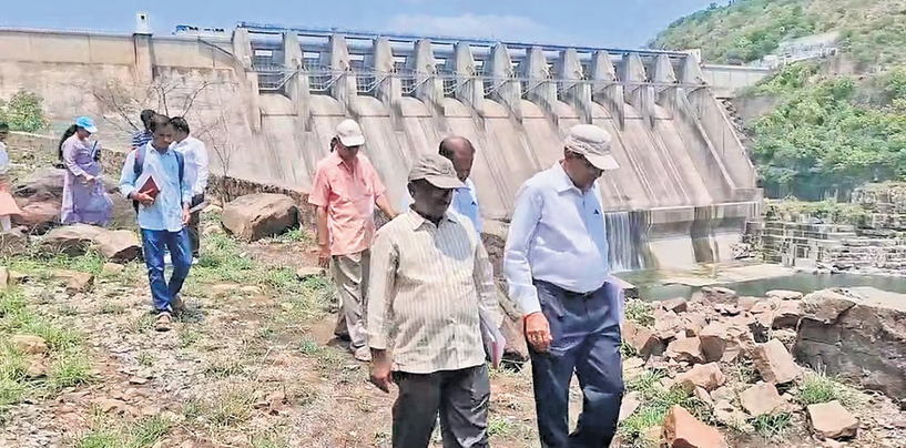
(Featue Image: A CDO team in May 2025 inspects the Srisailam Dam to assess its structural safety. Souce: TNIE)
It’s been five years since the Parliament passed the Dam Safety Act and the institutions including National and State Dam Safety committees and authorities were set up. However, how safe are our dams and how far have we achieved the Dam Safety Compliance norms? The answer to that question is unlikely to be confidence inspiring. This feeling is reinforced with a number of reports in recent weeks.
One key reason is that Central Water Commission, that was in charge of dam safety related issues before the Dam Safety Act and institutions came into existence, remains at the helm of the Dam Safety Committees and authorities. CWC also in charge of large number of functions related to dams and water issues including design of dams, sanctioning of dams, rule curve of dams, flood forecasting, financing of dams, technical approval of dams, monitoring of dams, collecting of water and river related data, seismic issues related to dams, siltation related to dams, environment clearance of dams, related policies and plans among others. These inevitably involves conflict of interest for CWC.
On top of this, the dam safety governance bodies have no independent members, no legally mandatory transparency requirements, and of course no accountability mechanisms. With each passing year, the number of old dams and dams with safety issues are only going to grow, also due to the changing rainfall patterns. One only hopes we bring credible governance change in these aspects before there is a major disaster.
NCDS Reviews Dam Safety Compliance The 12th meeting of the National Committee on Dam Safety (NCDS) was held in New Delhi under the chairmanship of the Chairman, Central Water Commission (CWC), to review the implementation of the Dam Safety Act, 2021. The committee discussed accelerating preparation of Emergency Action Plans (EAPs), Comprehensive Dam Safety Evaluations, Operation & Maintenance Manuals, and Risk Assessment Studies for specified dams, while also addressing emerging issues such as reservoir sedimentation, dam surveillance, and security.
It decided to frame new regulations on dam surveillance and security, update safety inspection procedures, prepare technical guidelines on hazard classification and risk assessment, strengthen capacity building through IITs, NITs and other institutions, and develop a framework for reporting dam failures.
The meeting also reviewed recent failures of the Luti Tank and Rajadera dams (Chhattisgarh), Teesta Stage-III Dam (Sikkim), Madhopur Barrage (Punjab), and reservoir dredging at Bisalpur Dam (Rajasthan). States were directed to complete all mandatory dam safety compliance requirements by December 2026.
Centre asks states to complete Dam Safety Evaluations by Dec, work on desiltation The central government has directed all states to complete the Comprehensive Dam Safety Evaluations by the end of 2026 and to take measures to address reservoir sedimentation.
Independent Expert Panels to Review Safety of 86 Tamil Nadu Dams The Tamil Nadu government has constituted independent Panels of Experts (PoEs) to conduct comprehensive safety assessments of 86 large dams, including the Mettur, Vaigai, Bhavanisagar and Mullaperiyar dams, in line with the Dam Safety Act, 2021. The panels will examine structural integrity, hydrological and seismic safety, operation and maintenance practices, instrumentation, emergency preparedness, and reservoir management. The first detailed safety evaluations are to be completed by December 30, 2026, after which periodic reviews will be undertaken to strengthen dam safety and ensure compliance with national standards.
Aging Meghadri Gedda Dam pose safety risk With water from the Polavaram project set to reach North Andhra soon, concerns have resurfaced whether the Meghadri Gedda reservoir, a crucial source of drinking water for Visakhapatnam, is equipped enough in receiving the Godavari River waters. Authorities of Water Resources department are particularly worried about the ageing floodgates installed nearly five decades ago at the reservoir, on Sept 27, 1977. They need to be replaced immediately. Otherwise, if Polavaram inflows increase or heavy rains occur in the catchment area, there is the fear of the gates giving way, threatening the Visakhapatnam City Airport and HPCL areas, among others. Dam gates will have to be lifted to prevent inundation of upstream villages in Visakhapatnam and Anakapalli districts. However, two of the six gates are non-functional; Gate Number 1 for 20 years and Gate Number 6 for 15 years. They can no longer be lifted using their roller mechanisms. Proposals to replace them have been repeatedly prepared. But they have remained stalled for lack of funds.
Officials, including Central Design Organisation executive engineer Vijaya Sarathi, consultant K.V. Krishna Rao, and district engineers, had recently inspected the gates. They confirmed the need for urgent repairs. Heavy rains typically cause the Meghadri Gedda, Narava Gedda, and Korramma Gedda streams, along with 60 upstream tanks, to overflow and channel water into the Meghadri Gedda reservoir. With Polavaram water expected soon, experts insist that all six gates must be operable to avoid flooding villages and parts of Visakhapatnam.
Officials had initially prepared an estimate of Rs 5.75 crore to replace the two defunct gates. However, Central Designs Organisation (CDO) subsequently carried out an inspection and recommended that all six gates be replaced, with rollers and stop-log systems, at an estimated cost of Rs 6–7 crore. The CDO underlined that the process would take six to seven months, as new gates and rollers will have to be custom built. GVMC, which relies on the reservoir for daily supply of 1.28 million cubic feet of drinking water, has accumulated dues of over ₹50 crore to the Irrigation Department. An Irrigation department official confessed that even minor works, such as painting, have not been completed due to a lack of funds.
HYDRO POWER PROJECTS
‘Halt Oju hydro project activities, disburse compensation’: Orgs The Nah Welfare Society (NWS) and the Mra Welfare Society (MWS) have jointly served an ultimatum to the government and the project implementing agency, demanding immediate halt to all ongoing activities relating to the Oju hydropower project over the Subansiri river in the Taksing-Limeking area in Upper Subansiri district until compensation is disbursed to all affected landowners. The two organisations stated that the landowners and local communities have been extending their full cooperation to the government and the project developer for the past 15 years.
Naying Hydro Project Gets Green Clearance On 14 July 2026, the EAC recommended environmental clearance for the 1,000 MW Naying Hydroelectric Project in Siang and Shi-Yomi districts, Arunachal Pradesh, near the India–China border. The run-of-the-river project, proposed by North Eastern Electric Power Corporation (NEEPCO) on the Siyom River, can now proceed to obtain other statutory approvals before construction begins. The project is expected to strengthen power generation and strategic infrastructure in the border region while raising concerns over its environmental and ecological impacts.
3rd 170 MW unit of NHPC’s Teesta V project resumes generation after 33 months NHPC’s 510 MW Teesta V project was badly damaged in Oct 2023 GLOF floods. Its third unit of 170 MW project started generation of power on July 16, almost 33 months after being damaged, with it all three units are not operating. It is not clear what is the total losses suffered by NHPC and if any investigation was done for who all were responsible for the damages to the project, since the project failed to take necessary actions.
Assam to harness SHP potential with 11 new projects: CM Participating in the general discussion on the Assam Budget 2026-27 in the Assembly, the CM on July 15 said the government will develop 11 small hydropower projects with a combined generation capacity of 137.2 MW at an estimated investment of Rs 2,617 crore.
The proposed projects will come up at Karbi Langpi Middle-I, Karbi Langpi Middle-II, Dhansiri, Lungnit, Disaidam, Bordikorai, Amring, Jenum, Klarang, Desang and Amphi, covering Karbi Anglong, Dima Hasao and other districts. To meet future energy requirements, the State Budget has proposed a Rs 77,353-crore investment roadmap spanning hydropower, solar energy, thermal generation and battery energy storage systems.
46,203 Ha Forest Land Diverted in Uttarakhand Since 2000 According to the RTI data, road projects (10,070 ha) and mining (9,290 ha) account for the largest share of forest diversion, while Dehradun district alone accounts for nearly 47% of the total diverted forest area. Citing a June 16, 2026, RTI response, Nautiyal told that road projects accounted for 10,070.03 hectares, or 22% of the diverted forest land, while mining accounted for 9,289.81 hectares. “Transmission lines used 3,005.51 hectares, power projects 2,250.08 hectares, irrigation works 456.18 hectares and drinking water schemes 294.56 hectares,” he said. Another 20,837.63 hectares, or 45% of the total, were classified as “Others”.
Norway firm to set up India’s first river kinetic energy demo plant in Arunachal The Arunachal Pradesh government’s Centre for Earth Sciences and Himalayan Studies on July 14, 2026 signed a memorandum of understanding with Norway’s Tidal Sails AS to establish India’s first kinetic energy demonstration plant. It will help the State implement a 500 kW project to demonstrate a technology to generate electricity directly from river currents without requiring major civil infrastructure.
On May 19, Council of Scientific and Industrial Research, Department of Scientific and Industrial Research, GoI Signed Five Key Agreements in Norway Covering Clean Energy, Offshore Wind, Sustainability, Geosciences and Academic Collaboration.
MoEF Clears Forest Land for 2 PSPs in Maharashtra’s ESZ The clearance covers the 2,100-MW Bhavali Pumped Storage Project in Nashik district and the 1,200-MW Bhivpuri Pumped Storage Project in Raigad district, both located partly within or near notified eco-sensitive zones around protected areas. The ministry permitted the use of several hundred hectares of forest land subject to conditions such as compensatory afforestation, wildlife management measures, catchment area treatment, and compliance with environmental safeguards. The projects are intended to support renewable energy integration and grid stability by storing surplus electricity and supplying power during peak demand. However, environmental groups have raised concerns that large-scale construction, tunnelling, transmission infrastructure and forest diversion in the Western Ghats could affect biodiversity, wildlife corridors, water sources and local ecosystems, and have sought stricter scrutiny of cumulative ecological impacts before implementation.
Sharavathi PSP This article compares the history of the Gerusoppa Hydroelectric Project with the ongoing Sharavathi Pumped Storage Project, showing how the people of Uttara Kannada have been forever battling hydropower projects, ports, river diversions, and even nuclear power installations. Perhaps it is because of this sustained public resistance that some of the district’s forests still remain. The article also provides a landscape-level assessment (including a map) of how these successive energy and infrastructure projects threaten the livelihoods, rivers, forests, and wildlife of Uttara Kannada. (Nirmala Gowda)
Karnataka Govt Defends Sharavathi PSP The Karnataka government has cited a report prepared by a National Institute of Advanced Studies (NIAS) professor to defend the proposed 2,000 MW Sharavathi Pumped Storage Power Project (PSP) in the ecologically sensitive Sharavathi Valley of the Western Ghats. The report reportedly concludes that the project can be implemented with limited ecological impact and argues that it would not pose a significant threat to the habitat of the endangered lion-tailed macaque, a key concern raised by environmentalists.
DAM SAFETY
July 2026: Two Landslide Incidents at Lakhwar Dam in Three Days The under-construction Lakhwar dam site on the Yamuna river in Dehradun district of Uttarakhand witnessed two landslide incidents within three days in July 2026. Although there was no loss of life, both incidents damaged construction machinery, exposed the risks faced by workers, and revived concerns about slope stability, construction practices and the suitability of building such a large dam in the fragile Himalayan region.
BBMB Seeks Shifting of Rail Track from Nangal Dam The Bhakra Beas Management Board (BBMB) has urged Northern Railways to relocate the railway track running over the 75-year-old Nangal Dam, citing concerns that increased train traffic and vibrations could affect the ageing structure’s safety. The track, originally built for limited freight movement, now carries around 17 trains daily, including the Vande Bharat, with traffic expected to increase further after the Amb Andaura–Talwara rail extension. BBMB has repeatedly written to the Railways seeking relocation of the line from the dam structure.
DAMS
SC asks Telangana to correct defects in Polavaram suit The Supreme Court on July 13, 2026 declined to hear Telangana’s suit challenging Andhra Pradesh’s proposal to construct the Banakacherla Cross Regulator under the Polavaram project, citing procedural defects. A bench of Justices Vikram Nath and Sandeep Mehta took note of the Supreme Court Registry’s report, which said notices had not been served on all 15 respondents named in the original suit. The court also clarified that neither the issuance of notices nor the plea for interim injunction could be considered until the petition is refiled after the defects are removed in accordance with the Supreme Court Rules. The bench then adjourned the matter and directed Telangana to rectify the objections and complete service of notices on all respondents, after which the case would be listed for hearing. The dispute relates to Andhra Pradesh’s proposal to construct the Banakacherla Cross Regulator as part of the Polavaram project, which Telangana claims will affect its share of river water.
CSMRS Clears Materials for Polavaram ECRF Dam A team from the Central Soil and Materials Research Station (CSMRS) completed a two-day quality assessment of construction materials being used for the Earth-cum-Rock Fill (ECRF) Dam component of the Polavaram Project in Andhra Pradesh. The experts tested rock, soil and sand across different sections of the dam and found that all materials met the prescribed engineering standards. The inspection is part of the project’s independent quality assurance process, with further testing scheduled to ensure construction safety and compliance.
CM N. Chandrababu Naidu said the Polavaram Multipurpose Project and the renovation of the historic Sir Arthur Cotton Barrage (Dowleswaram Barrage) will be completed before the Godavari Pushkarams in 2027. Reviewing the progress of irrigation works, he directed officials to accelerate construction and ensure timely completion of both projects.
Kaleshwaram project: Telangana HC notice to Centre, state The Telangana High Court on July 15 issued notices to the Central and State governments in a writ petition seeking a direction to the National Dam Safety Authority to inspect different barrages and pumphouses of Kaleshwaram Lift Irrigation Scheme project and submit a report on the feasibility of partial utilisation of the project.
Justice B. Vijaysen Reddy of the HC, after hearing contentions of the petitioner Srirambhatla Sharath Kumar, a practicing advocate of the HC, directed the Deputy Solicitor General to appear before the bench on July 21 when the matter would be heard again. The judge issued notices to Union Ministry of Jal Shakti’s secretary, Telangana Chief Secretary, principal secretary (irrigation and command area development) and the Telangana Retired Engineers’ Association. They were directed to file their responses by the next date of hearing.
Increasing questions as to why Kaleshwaram is not repaired and utilised so far The central question is no longer whether irregularities occurred in the construction of Kaleshwaram, but why a project built with public money remains underutilised despite experts suggesting that water can still be lifted through other components of the integrated system while investigations continue. Kaleshwaram is not just Medigadda, as it comprised an interconnected system of barrages, reservoirs, tunnels, canals and pumping stations, many of which remained intact. If one component requires repairs, the rest of the system should be utilised wherever technically feasible. Corruption should invite prosecution of those responsible, but should not become grounds to deny farmers the benefits of an existing irrigation network.
Mamallan reservoir yet to get NOC from fisheries department Amid fierce opposition against the ongoing Mamallan Reservoir project from fishermen and environmentalists, the fisheries department on Tuesday revealed that it has not accorded the mandatory no-objection certificate (NOC) to the Water Resources Department for the project. Responding to a query, fisheries officials clarified that an NOC is a prerequisite for carrying out any work close to the shore. Then chief minister MK Stalin had laid the foundation stone for the Rs 342-crore project in January. Several fishermen alleged that the reservoir project had been started illegally and demanded that the works be halted. “If the reservoir project is completed, there will be no prawns in the sea”.
Cauvery Delta Opposes Mekedatu Dam Proposal Farmers and residents in Tamil Nadu’s Cauvery delta have renewed opposition to Karnataka’s proposed Mekedatu balancing reservoir, fearing it could reduce downstream river flows and threaten irrigation, drinking water supply, fisheries, and the fragile delta ecosystem. Although Karnataka maintains that the project is intended to store surplus monsoon flows for Bengaluru’s drinking water needs and hydropower generation without affecting Tamil Nadu’s allocated share, delta stakeholders argue that additional upstream storage could alter the timing and volume of water releases, particularly during distress years.
DMK Seeks Central Tribunal for Mekedatu Dam Dispute On 17 July 2026, the DMK urged the Union Government to constitute a dedicated tribunal to permanently resolve the Mekedatu dam dispute and safeguard Tamil Nadu’s share of Cauvery River water.
NBA Demands Rehabilitation Before Development Projects On 13 July 2026, the Narmada Bachao Andolan (NBA) asserted that Madhya Pradesh’s legitimate developmental interests should not come at the cost of thousands of families displaced by Narmada Valley projects. The movement urged the state government to ensure complete rehabilitation and resettlement of all project-affected people before proceeding with further development works, in accordance with the Narmada Water Disputes Tribunal Award and Supreme Court directives. NBA alleged that many displaced families continue to await land rights, compensation and basic rehabilitation benefits, despite being affected for years.
Relevant decisions of MoEF’s Forest Advisory Committee meeting held on July 6 2026
1. Diversion of 60.276 ha forest land for the construction of Dam-4 under the Sher Irrigation Complex Project in favour of Dept of Irrigation in the Seoni dist of Madhya Pradesh: Deferred, more info sought
2. Diversion of 6.0 ha. of forest land for regularization of existing 80 MLD Water Treatment Plant which is used to supply water to Solapur City and 66 MLD Newly proposed Water Treatment Plant for enhance the water supply of Solapur City in favour of Solapur Municipal Corp at Village Pakni, Taluka North Solapur, Dist. Solapur Maharashtra: More info sought.
INTERLINKING OF RIVERS
Police and administration forcibly stop ‘pyre protests’ Local police and administration brought to an end the ‘Chita Andolan’ (pyre protests) being held since July 3, 2026, by people affected by the Ken-Betwa Link and other projects near Kupi village in the Chhatarpur district of Madhya Pradesh. At 5 am on the morning of July 19, a large number of police and administrative officials arrived at the site and took away hundreds of people—including movement leader Amit Bhatnagar—in vehicles. July 19 marked the seventeenth day of the ‘Chita Andolan’ and the fourteenth day of Amit Bhatnagar’s hunger strike.
‘Funeral Pyre Protest’ Against Ken–Betwa Project Resumes Organised by the Jai Kisan Sangathan under the slogan “Nyay Do Ya Mar Do” (Give Us Justice or Let Us Die), the protesters accuse the administration of violating land acquisition and rehabilitation laws, filing false criminal cases against activists, carrying out illegal evictions, cutting electricity, and demolishing schools and places of worship in affected villages.
SANDRP coordinator Himanshu Thakkar criticised the project for relying on outdated hydrological estimates (2003–04) despite the absence of any recent scientific assessment of water availability in the Ken basin. He said internal government correspondence itself reflects uncertainty over the annual yield at the proposed Daudhan Dam, while the Supreme Court’s Central Empowered Committee (CEC) had earlier questioned the assumption that the Ken River has “surplus” water.
Thakkar also pointed out that mandatory conditions attached to the Stage-I (2017) and Stage-II (2023) forest clearances, including fresh tree enumeration, are reportedly being violated. He argued that the project would submerge over 9,000 hectares of dense forest, including critical tiger habitat, and called for an independent evaluation of less destructive and more cost-effective alternatives, such as strengthening Bundelkhand’s existing irrigation and water conservation systems instead of pursuing a large dam and river-linking project.
Villagers have launched a “Phansi Satyagraha” (Hanging Protest) to draw attention to their concerns over displacement, inadequate rehabilitation and compensation. Protesters say the project, promoted as a solution to water scarcity and irrigation needs in Bundelkhand, has instead brought uncertainty and fear for families living in the submergence area.
The report features affected villagers living along the Biarma River, who allege that many families have neither received fair compensation nor proper rehabilitation. They also claim that land acquisition has lacked transparency and that people have not been adequately informed about their rights. Women participating in the protest demand equal recognition in compensation and rehabilitation policies, arguing that their interests are often overlooked.
Ken Betwa: allegations of gram sabha violations & corruption Leader of the Opposition in the Madhya Pradesh State Assembly alleged gram sabha violations and corruption worth crores in the distribution of compensation and in awarding contracts to companies. He also demanded independent investigation.
According to villagers, compensation amounting to around ₹11 crore was sanctioned for houses in Kharihani village. However, available documents indicate that around ₹8 crore was paid to individuals who had no connection to the village or had already left it between 1980 and 1990 and several people genuinely affected were yet to receive compensation. The protestors have identified more than 500 cases of alleged fraudulent compensation payments on the basis of documentary evidence. Residents of several villages, mostly tribals from Panna and Chhatarpur districts, have been protesting on the banks of the Barana River near Kupi village for nearly two weeks, with several demonstrators tying nooses around their necks and lying on makeshift pyres in the river in a symbolic protest.
The backlash against the Ken-Betwa river linking project and protests in Uttarakhand against infrastructure expansion are indicators of wider concerns about environmental governance in India. At the heart of all of these concerns is the EIA (Environmental Impact Assessment) framework, a legislative process designed to balance development and environmental sustainability. But it is under attack. (Anusreeta Dutta, Zahid Sultan)
River Linking Projects As Flood Solution in Bihar: Experts This report examines whether river-linking projects can provide a permanent solution to Bihar’s recurring floods. While the Centre and the Bihar government are promoting river interlinking as a major flood mitigation strategy, experts caution that the projects have significant limitations and cannot eliminate flooding in the state.
According to the report, Bihar currently has six intra-state river-linking projects proposed under the National Water Development Agency (NWDA). Among them, the Kosi–Mechi Link Project is the most advanced and is under implementation. Other proposed links include Bagmati–Adhwara, Burhi Gandak–Noon-Baya-Ganga, Kosi–Mochi, Karmanasa–Sone, and Kiul–Harohar river links. The Kosi–Mechi project involves constructing a 76-km canal to divert surplus water from the Kosi to the Mechi River, with the stated objectives of providing irrigation and reducing flood impacts in parts of north Bihar.
Bargi Diversion tunnel completed after 17 yrs India’s longest underground water conveyance tunnel was completed after 17 years on July 14 2026 after engineers achieved the final breakthrough in the 11.95-km Sleemanabad passage. The tunnel is part of the Bargi Right Bank Main canal with capacity of 227 cumecs. The larger Bargi Diversion Project is expected to provide irrigation to about 2.45 lakh ha across nearly 1,450 villages in Jabalpur, Katni, Satna, Maihar, Rewa and Panna.
Narmada water will be released into the system once the tunnel boring machine (TBM) is dismantled and pulled out. The Tunnel cuts through the Vindhya range to take Narmada water to Son Basin, Son being a southern tributary of Ganga. Incidentally, in Govt’s Interlinking of Rivers Plan, Narmada is a deficit river and Ganga a surplus river, so this project ends up transferring water from a deficit basin to a surplus basin, an example of Ulti Ganga, as they say.
INTERSTATE WATER DISPUTES
Rajasthan share of water in Gujarat’s Kadana Dam remaining unused Relief from water scarcity could reach the people of Barmer, Balotra, Sirohi, Jaisalmer and Jalore districts of Rajasthan, as a share of water belonging to these Rajasthan districts has been going to waste at Gujarat’s Kadana Dam for nearly two decades. This could finally be secured if the Gujarat and Rajasthan governments reach a joint agreement — with the water sitting just 17 kilometres from the Rajasthan border.
The Mahi Project was built in 1966, and by 1979 the dam at Gujarat’s Kadana had been completed. The site lies a mere 17 kilometres from Rajasthan. A total of 87 thousand million cubic feet (TMC) of water reached the reservoir, and under the original plan, 28 TMC of this was meant to be allocated to Rajasthan.
The project was to have canal network to deliver it to more than 650 villages and hamlets. The scheme was designed to serve both irrigation and drinking water needs. However, after completing its portion of work up to Kadana, the Gujarat government halted further progress. The remaining work was meant to proceed through a bilateral agreement between the two states, but Gujarat did not cooperate further. Of the total 337km high-level canal that was to be built, 320km was constructed — entirely within Gujarat.
Karnataka Refuses Cauvery Release Citing Poor Monsoon At the CWRC meeting on July 16, Karnataka stated that the available water was barely sufficient to meet drinking water requirements and that several parts of the state were facing drought-like conditions. Tamil Nadu sought continuous water releases for at least 15 days, citing significantly lower inflows compared to previous years. However, the CWRC acknowledged the weak monsoon and depleted reservoir levels and did not direct Karnataka to make immediate releases. Instead, it advised all basin states to prioritise drinking water, conserve available supplies and maintain minimum environmental flows, with the issue to be reviewed again at the next meeting on 28 July 2026.
Weak Monsoon Pushes Cauvery Flow to Historic Low The report states that weak rainfall in the Kodagu (Coorg) catchment—the principal source region of the Cauvery—has drastically curtailed river flows. As a result, Karnataka has struggled to release water downstream, while Tamil Nadu faces uncertainty over irrigation for the ongoing kuruvai paddy season. The situation has also affected Kerala and Puducherry, which depend on the Cauvery basin for water. Experts stress the need for improved reservoir management, efficient water use, watershed conservation and long-term climate adaptation measures to address recurring water stress.
URBAN RIVERS
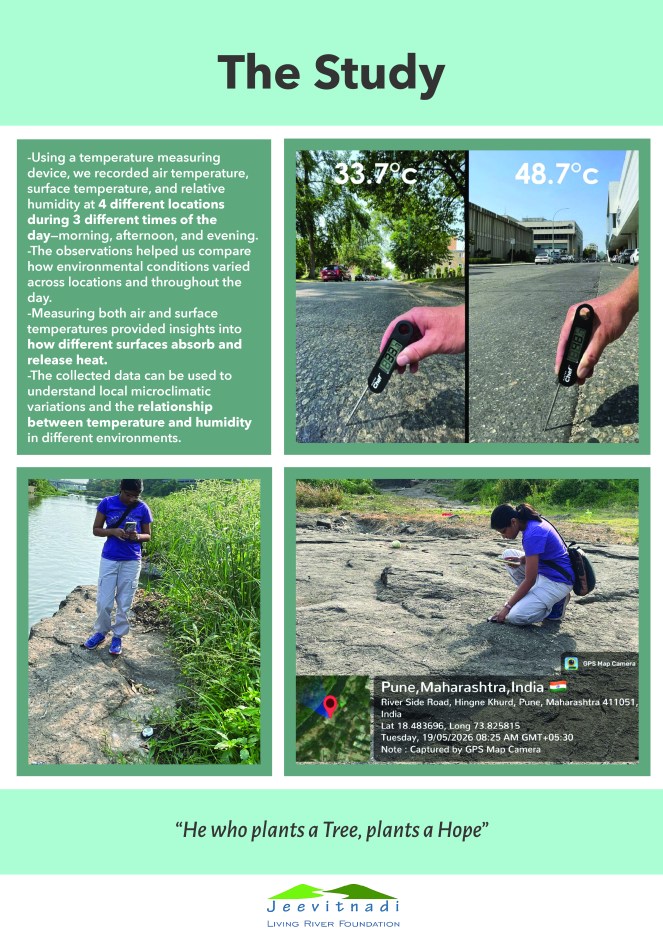
Riparian Forest 22 degrees Celsius cooler than the Riverfront Project! Tara Tanmayi writes about an interesting Citizens Science Initiative in Pune to understand a relatively unknown impact of river front development project in Pune. The initiative, from their early investigations show that at times during summer, the concrete exposed surfaces of River Front Project in Pune were upto 22 degrees Celsius hotter than some of the natural river bank locations. This is a remarkable early finding of this ongoing initiative by Jeevitnadi volunteers in Pune.
Gomti RFD: Hidden environmental price The report argues that the Gomti Riverfront Development Project in Lucknow has transformed the river into an engineered urban corridor at a significant ecological cost. Approved in March 2015 at an estimated cost of ₹656.58 crore, the project involved channelising an 8.1-km stretch of the river, constructing concrete embankments on both sides, narrowing the floodplain from about 450 metres to 240 metres, and reclaiming nearly 200 hectares of floodplain land for urban use. While the project aimed to beautify the riverfront, improve flood management, create recreational spaces and clean the river, the article argues that many of these objectives have not been achieved.
The report states that extensive concretisation has disrupted the Gomti’s natural morphology and severely degraded its ecological functions. The river’s diverse floodplain ecosystem has reportedly been reduced from eight habitat types to just two, resulting in habitat loss, reduced groundwater recharge and weakened flood buffering capacity. Despite the large investment, untreated sewage continues to enter the river through multiple drains, with studies showing that the Water Pollution Index has increased by over 170% in some stretches.
The article concludes that urban river restoration should prioritise ecological health rather than cosmetic beautification. It recommends protecting floodplains, restoring natural river processes, intercepting and treating sewage before it reaches the river and adopting nature-based approaches instead of relying primarily on concrete engineering for riverfront development.
Residents plan NGT move over Musi RFD A delegation from Madhu Park Ridge (MPR) Apartments at Bandlaguda Jagir met the Chairman of the State Environment Impact Assessment Authority (SEIAA), Telangana, in the city on July 16 and demanded reconciliation of discrepancies in the Environmental Impact Assessment (EIA) and Environmental Management Plan (EMP) reports for the Musi Riverfront Development Project. The delegation said it would approach the NGT if environmental clearance was granted without addressing the discrepancies. The MPR delegation said around 400 flats in Madhu Park Ridge would be affected as part of the Gandhi Sarovar Project linked to the Musi Riverfront Development Project.
RIVERS
Geologists got it wrong: Rivers didn’t need plants to meander Stanford researchers reveal meandering rivers existed long before plants, overturning textbook geology. Their findings suggest carbon-rich floodplains shaped climate for billions of years.
The findings offer a provocative new window into Earth’s past eons, upending the conventional picture of how rivers have sculpted continents. If indeed carbon-loaded floodplains were laid down far more extensively over history, scientists may need to revise models of major natural climate swings over time, with implications for our understanding of ongoing climate change.
While the model is simplified—it does not include full fluid dynamics, sediment heterogeneity, or flood variability—it provides a clear counterfactual experiment: no real river can evolve without cutoffs, but simulations can, revealing the mechanism behind chaotic divergence. This approach connects geomorphology with fundamental concepts from chaos theory, offering a concrete way to quantify a river’s predictability horizon.
Why does the river move sideways rather than just widening the channel? The answer lies in a phenomenon called helicoidal flow. Imagine a corkscrew-shaped movement of water within the channel. As water flows around a bend, the centrifugal force pushes the faster surface water toward the outer bank. To compensate, a secondary, slower current flows along the riverbed from the outer bank toward the inner bank.
Study Finds 20% Decline in Rainfall in Eastern Indus River Basins Since 1951 A first-of-its-kind study by Prof. Vimal Mishra and Urmin Vegad of IIT Gandhinagar has found that the catchments of the Ravi, Beas and Sutlej rivers have witnessed a 20% decline in precipitation between 1951 and 2024, while rainfall over the Indus, Jhelum and Chenab basins declined by only 6%, a change that is statistically insignificant. The study also reports significant groundwater depletion in the Sutlej and Ravi sub-basins, indicating reduced water availability in India’s eastern Indus basin. The findings are significant in the context of India’s demand to review and modify the Indus Waters Treaty, arguing that climate change, changing hydrology, population growth and rising water demand have fundamentally altered water availability since the treaty was signed in 1960. The research is expected to provide scientific evidence supporting the need for climate-informed transboundary water management.
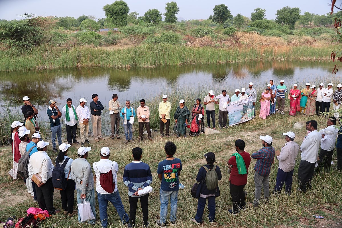
Communities Reconnect with Rivers Through Walking Rivers Initiative This report describes Walking Rivers initiative, a global movement that brought together around 500 participants across Andhra Pradesh, Maharashtra, Gujarat and Karnataka to reconnect communities with freshwater ecosystems through guided walks along the Papagni, Waghadi, Mahi and Chitravathi rivers. Organised by the Foundation for Ecological Security (FES), the initiative promoted river stewardship through biodiversity documentation, storytelling, nature journaling and discussions on catchment restoration, sustainable agriculture and water conservation. The article notes that India’s rivers face mounting pressures from urbanisation, deforestation, mining, dams, pollution and agricultural expansion, leading to declining biodiversity, deteriorating water quality and reduced groundwater recharge. By encouraging communities to view rivers as living ecosystems rather than merely water sources, the initiative seeks to strengthen public participation in conserving and restoring India’s freshwater commons.
Illegal Lotus Cultivation Threatens Thamirabarani Wetlands On 8 July 2026, The Times of India reported that illegal commercial lotus cultivation in irrigation tanks across the Thamirabarani River basin is degrading ecologically important wetlands and disrupting the region’s traditional irrigation system. Conservationists warned that farmers are converting large stretches of wetlands into lotus farms by excavating ponds, erecting bunds and using chemicals, altering natural hydrology, reducing water availability for irrigation, and damaging wetland biodiversity. The practice has affected several irrigation tanks in Tirunelveli and Thoothukudi districts, threatening aquatic habitats, fisheries and the livelihoods of communities dependent on these wetlands. Environmentalists have urged the Water Resources Department (WRD) to remove illegal lotus cultivation, restore affected wetlands and strengthen monitoring to protect the ecological integrity of the Thamirabarani river basin.
Environmentalists Oppose Narmada Path Gaman Project On 12 July 2026, environmentalists opposed the proposed Narmada Path Gaman Project, under which the Madhya Pradesh government plans to develop infrastructure such as pilgrim pathways, ghats, resting facilities and other amenities along the Narmada River to support the traditional Narmada Parikrama. Conservationists argued that the project could violate the 300-metre no-construction zone along the riverbanks prescribed by the Madhya Pradesh High Court, conflict with NGT directions protecting floodplains, and threaten the river’s biodiversity and ecological integrity.
Environmental lawyer Rashid Noor Khan said that, instead of promoting new construction, the government should focus on addressing existing issues such as sewage discharge, industrial pollution, illegal sand mining, encroachments and degradation of tributaries. He also demanded that the DPR be made public and warned that the matter would be challenged before the NGT and other judicial forums if environmental safeguards are ignored.
Dying Keleghai river Threatens Bengal’s ‘Nadya’ Dialect In a report published on 14 July 2026, Madhurima Pattanayak highlights how the gradual decline of the Keleghai River in Purba Medinipur, West Bengal, is not only degrading a freshwater ecosystem but also threatening the survival of ‘Nadya’, a unique riverine dialect spoken by traditional fishing communities. The river has been shrinking due to reduced freshwater flows, siltation, embankments, pollution and changing river morphology, leading to declining fish populations and the erosion of livelihoods dependent on the river.
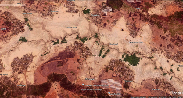
As younger generations migrate or abandon traditional occupations, the dialect, oral traditions and cultural practices closely tied to the river are also disappearing. Linguists and conservationists argue that protecting rivers is essential not only for ecological restoration but also for preserving the cultural heritage and linguistic diversity of river-dependent communities.
Namami Gange: Billions Spent, Yet Ganga Remains Polluted The report notes that while sewage treatment plants, riverfront development and other infrastructure have expanded under the program, many projects remain incomplete or underperform, allowing untreated wastewater to continue entering the river. Experts argue that the focus has been on infrastructure creation rather than ensuring effective operation, monitoring, ecological restoration and enforcement. The article stresses that restoring the Ganga requires not only pollution abatement but also maintaining environmental flows, protecting floodplains and wetlands, regulating industrial discharges, and strengthening accountability of implementing agencies.
Yamuna Manthan July 2026: River without Flows Even During Monsoon It is well known that excessive diversion of Yamuna waters at the Hathnikund Barrage (HKB) in Yamuna Nagar, Haryana over the past two-and-a-half decades has turned the perennial river into a seasonal stream in its upper reaches during the lean season. However, an analysis of the Central Water Commission’s (CWC) hourly discharge figures and hydrographs since July 1, 2026 reveals that the river is now being deprived of its essential flows even during the monsoon.
Higher monsoon inflows at Hathnikund fail to boost Yamuna’s flow Monsoon rains increased water inflows at Hathnikund Barrage over the past fortnight. However, most additional water was diverted into canals, leaving river flows unchanged. SANDRP expresses concern that this practice hinders the river’s natural ability to dilute pollutants. Environmental flows recommended by NIH for the Yamuna remain unnotified by the Ministry of Jal Shakti. Restoring adequate environmental flows upstream is critical for the Yamuna’s long-term revival.
Width–Discharge Dynamics of the Urbanised Yamuna River in Delhi Abstract: This study investigates the impact of multiple barrages built on the 50-km-long reach of the Yamuna River in Delhi. We used historical maps and satellite images to determine changes in river width and flow dynamics over the past two centuries. Results show that the Yamuna River in Delhi has narrowed by about 68%, and its discharge has reduced by about 89% from 1799 to the present day. Over the past century (1912-2024), man-made embankments have disconnected about 33% of the floodplains. These changes in river width, discharge, and land-use with increasing population have reduced the natural capacity of the river to adjust to extreme events.
Over 225 years while Delhi grew, Yamuna kept shrinking, lost 68% width, 89% flow These findings of a study by scientists from Delhi University’s Department of Geography and the Indian Institute of Science Education and Research (IISER), Bhopal, who pieced together the Yamuna river’s transformation using a map dating back to 1799, historical records and satellite imagery spanning over 2 centuries. The Yamuna flowing through Delhi has lost nearly 68 % of its average width, while the volume of water reaching the city has declined by 89 % over the past 225 years.
The construction of barrages at Tajewala, Okhla, Wazirabad and ITO diverted substantial volumes of water before it entered Delhi, reduced the river’s natural flow. As the city’s population expanded from about two lakh in the early nineteenth century to nearly 2.15 crore today, demand for land and water intensified. Floodplains were cut off by embankments and development projects, with around 45 sq kms of these natural buffers disappearing between 1912 and 2024.
“The river’s ecological features have thinned alongside it. Sandy mid-channel islands that once covered nearly 20 sq km in 1985 have shrunk to just 4 sq km by 2020, signalling the loss of habitats that helped maintain the river’s ecological balance,” the report says. The report concludes that restoring the Yamuna will require looking beyond pollution control. Protecting natural river flows, reconnecting floodplains and preserving ecological processes, it argues, are essential if Delhi is to reduce future flood risks and prevent further degradation of its lifeline.
Delhi pushed Yamuna to the brink Rapid urban expansion across the Upper Yamuna Basin is shrinking water bodies, degrading floodplains and intensifying pollution. A new study warns that unless ecological limits guide future growth, Delhi’s river system could face irreversible decline.
A recent study published in Environmental and Sustainability Indicators offers one of the most detailed assessments to date of how land use and land cover changes are reshaping the Upper Yamuna Basin and undermining river health in Delhi. The study by Neenu and Mitthan Lal Kansal, titled, ‘Multi-level intensity analysis of LULC change in the Upper Yamuna Basin and its impact on river health in the Delhi region’, examines two decades of landscape change between 2004 and 2024 and reveals how urban growth is steadily eroding the ecological foundations that sustain the river.
Water bodies in the basin shrank from 1.36 percent of the total area in 2004 to just 0.62 percent by 2024. In Delhi, they declined from 1.88 percent to 1.60 percent over the same period. Using Cellular Automata-Artificial Neural Network (CA-ANN) modelling, the researchers forecast that water bodies in the basin could decline by more than 40 percent between 2024 and 2034 alone.
The Upper Yamuna Basin is now approaching a tipping point where urban growth, hydrological stress, ecological decline, and climatic vulnerability are reinforcing one another. Unless land-use transitions are brought under ecological regulation, future river restoration investments may continue treating symptoms while the underlying drivers worsen unchecked. The Yamuna’s future will ultimately depend not only on cleaning drains or building treatment plants but also on whether India is willing to redesign urban growth around ecological limits rather than against them.
The study warns that continued encroachment and degradation of the floodplain threaten the Yamuna’s ecological health and resilience. The researchers recommend protecting and restoring floodplains, restricting further development in the river corridor, improving environmental flows and integrating river-sensitive planning into Delhi’s urban development strategy.
Experts warn that the shrinking of the Yamuna has weakened its ecological resilience, reduced groundwater recharge, increased pollution and heightened flood risks, as the river has lost much of its natural floodplain and carrying capacity. The findings underscore the urgent need to restore environmental flows, protect floodplains and integrate river-sensitive planning into Delhi’s future urban development.
Unchecked Urbanisation Threatens Yamuna’s Survival in Delhi The article highlights that shrinking floodplains, encroachments, wetland loss and increasing pollution have weakened the Yamuna’s natural ecological functions. These changes have also heightened Delhi’s vulnerability to urban flooding, heat stress and water scarcity, while further degrading river health.
The report argues that conserving the remaining floodplains and wetlands is essential for restoring the Yamuna’s ecological integrity. It calls for stronger land-use regulation, protection of floodplain ecosystems, integration of river-sensitive planning into urban development and improved governance to balance the city’s growth with the river’s long-term sustainability.
Treat the Yamuna as a Living River, Not a Drain This editorial argues that the Yamuna’s worsening condition reflects decades of fragmented governance, excessive sewage discharge, floodplain encroachment, and inadequate environmental flows. It concludes that the Yamuna’s revival demands long-term, science-based river basin management, transparent governance, and sustained political commitment, rather than piecemeal clean-up projects focused only on pollution control.
NGT Pulls Up Haryana On 17 July 2026, the NGT sharply criticised the Haryana government over the accumulation of nearly 30 lakh metric tonnes of legacy waste and the continued discharge of untreated sewage across the state. The NGT warned that continued non-compliance posed serious risks to public health, groundwater, rivers and the environment, and stressed the need for strict accountability and effective implementation of waste management measures.
Youth Clean Up Banas River close to its Source of Origin The Banas River sustains ecosystems and communities across a large stretch of Rajasthan, yet pollution had reached even its upper reaches near the river’s source. Disturbed by the growing neglect, a group of young volunteers came together to remove over 100 sacks of waste from the river and its banks, inspiring wider community participation. Their initiative, supported by local organizations, has expanded into campaigns for waste reduction and tree planting. (by Bharat Dogra)
RIVERS BIODIVERSITY
New Damselfly Species Discovered in Western Ghats Researchers have discovered a new species of damselfly, Lestes paloti, in the Western Ghats of Kerala, adding to the region’s rich biodiversity. The species was identified by a team of Indian researchers and described in the International Journal of Odonatology. Scientists noted that the discovery highlights the ecological significance of the Western Ghats and the need to conserve its freshwater streams and forest habitats, which support many endemic species. The finding also underscores the importance of continued biodiversity surveys in one of the world’s major biodiversity hotspots.
SAND MINING
Illegal mining in Baghpat, Uttar Pradesh The NGT, on July 14, 2026 expressed dissatisfaction with the report filed by the Director, Geology and Mining Directorate, Uttar Pradesh, concerning illegal mining in Baghpat district. The court pointed out that the report was not filed by way of affidavit and was not signed by the Director, Geology and Mining, Uttar Pradesh or any other duly authorized officer. The report also fails to provide complete information regarding the implementation of the court’s directions and action taken concerning incidents of illegal mining particularly in district Baghpat and the measures taken by the District Task Force Baghpat regarding these incidents.
The court directed the Director, Geology and Mining Directorate, to file a compliance report. Uttar Pradesh Pollution Control Board (UPPCB) filed a compliance affidavit on April 10, 2026 mentioning that Smart Mart Stores had deposited an EC amount of Rs 4,63,563 on November 20, 2025 and that this amount will be utilized for plantation along a 5 km stretch of the bandh between Mavikalan and village Alipur.
Rajasthan tribals challenges mining to protect river, hills The report documents the resistance of the Meena Adivasi community in Deepawas village, Neem Ka Thana (Sikar district), Rajasthan, against a proposed iron ore mining project, arguing that it threatens their forests, water sources, agricultural land and the fragile Aravalli hills. Villagers have adopted the slogan “For our river, for our hills”, describing the struggle as one to protect their environment and livelihoods rather than merely oppose mining.
The mining lease, covering about 180 hectares, includes nearly 149 hectares of forest land. Residents allege that mining would destroy hill slopes, reduce groundwater recharge, pollute local streams and affect the seasonal river on which nearby villages depend. The community also fears the loss of biodiversity and grazing land that supports their agriculture and livestock.
ED Raids in Punjab Illegal Sand Mining Probe The Enforcement Directorate (ED) conducted searches at 17 locations across Pathankot, Amritsar, and Gurdaspur in connection with a money laundering investigation linked to illegal sand mining near the India–Pakistan border. The raids included the premises of an alleged aide of a Punjab AAP minister. The agency is also examining the allotment of 92 acres of panchayat land near the international border, suspecting irregularities in land allocation and possible proceeds of crime. The investigation is based on multiple FIRs registered by the Punjab Police, and officials are probing financial transactions, mining operations, and the alleged role of individuals associated with the case.
ED Raids Regarding ₹131-Cr Bihar Illegal Sand Mining Case On 17 July 2026, the ED conducted searches at eight locations across Bihar, Delhi and Rajasthan in connection with an alleged ₹131-crore illegal sand mining and money laundering case. The raids targeted Mahadev Enclave Pvt. Ltd., controlled by the Chandak family of Sri Ganganagar, Rajasthan, following an investigation initiated on the basis of an FIR filed by Bihar’s Mines and Geology Department. According to the ED, a geospatial analysis by IIT Patna revealed large-scale unauthorised sand excavation in Banka district between 2015-16 and 2022-23, causing significant loss of government revenue. The searches covered locations in Banka and Patna (Bihar), Delhi, Jaipur, and Sri Ganganagar (Rajasthan) as part of the probe into the alleged proceeds of crime generated through illegal mining and laundering of funds.
Overloaded Sand Tractor Runs Over Biker in Himachal A 36-year-old motorcyclist was critically injured after an allegedly overloaded sand-laden tractor-trolley ran over his bike near Pir Baba Temple in Thakurdwara, Indora subdivision of Kangra district, Himachal Pradesh. According to reports, the tractor, carrying sand stacked so high that it obstructed the driver’s rear view, struck the motorcycle while taking a turn, crushing the rider’s leg under its double rear tyres. The victim was referred to DMC Ludhiana in critical condition. Police also found that the tractor had no registration number and have registered a case against the driver, seized the tractor-trolley and motorcycle, and launched further investigation.
WETLANDS, LAKES, WATER BODIES
Fishers, naturalists worry about the impacts of turning a coastal wetland into a reservoir Tamil Nadu is converting a coastal wetland in Chennai into a reservoir. Called Mamallan reservoir, it will be the city’s proposed sixth drinking water source. Naturalists and conservationists say the project’s environmental assessment raises questions about its claims on flood mitigation, groundwater recharge and ecological impacts. The site is a critical habitat for migratory birds, which will be impacted if the landscape changes. Fishing communities who depend on the wetland also worry about the project’s impact on their livelihoods. The Mamallan reservoir aims to supply 170 MLD for the city’s needs. The reservoir is designed to store 1.65 thousand million cubic feet (TMC) in a single filling and an annual storage of 2.25 TMC.
On January 19, 2026, the foundation stone was laid for the reservoir project. Since then fishing communities in the area have been opposing and protesting the move. On June 16, fishing communities from the nearby villages gathered at the Kovalam fish market to oppose the project and called for the new state government to scrap it. But the project remains underway.
Harike wetland at risk due to Sutlej Pollution Harike Pattan, home to Asia’s largest wetland, has become a stark symbol of Punjab’s river pollution crisis. At this confluence, the cleaner waters of the Beas meet the dark, contaminated flow of the Sutlej, raising alarm among environmentalists and local communities. Large volumes of untreated industrial and domestic waste, particularly from Ludhiana’s Budha Nullah and other tributaries, are polluting the Sutlej. The river water deteriorates to Class E — unfit for drinking or irrigation — after receiving effluents from the Budha Nullah.
The impact is most visible at Harike, feeding the Rajasthan Feeder and Sirhind Feeder canals. These canals supply irrigation water to thousands of villages across Punjab and Rajasthan. The contamination threatens agriculture, biodiversity and public health far downstream. 16,672 kg per day of BOD containing arsenic, chromium and other toxins are discharged into the river. Over 700 MLD of wastewater from Ludhiana and 350 MLD from Jalandhar enter the Sutlej system. Despite sewage treatment plants untreated water continues to flow into the river.
Jas Kirat Singh of Kala Pani Morcha said the issue was taken to the National Green Tribunal, which, in December 2024, directed industries to stop discharging untreated effluents. “Despite these directions, pollution remains a major concern,” he said.
AP High Court Stops Pond Excavation for Highway Project The Andhra Pradesh High Court quashed district administration orders permitting excavation of sand and gravel from the Kannamnaidu village pond in Vizianagaram for the NH-130CD project. Invoking the Public Trust Doctrine, the court observed that water is sacred across Hinduism, Islam and Christianity, and held that ponds and other water bodies are critical public assets that cannot be exploited by bypassing mining and environmental laws. The pond irrigates nearly 2,000 acres and supports groundwater recharge and local water security.
RAMSAR WETLANDS
EKW Face Growing Threat Despite legal protection under the East Kolkata Wetlands (Conservation and Management) Act, 2006, the wetland area has reportedly shrunk from around 65 sq km to about 41 sq km over the past three decades due to illegal filling and rapid urbanisation. Studies cited in the report indicate that more than half of the wetland ecosystem has undergone ecological changes in the last two decades, threatening its ecological functions and the livelihoods of thousands of people dependent on sewage-fed fisheries and farming.
The report notes that the wetlands perform multiple ecosystem services by filtering nearly all of Kolkata’s wastewater through natural processes before it reaches the river system. However, increasing pollution, real estate pressure, fragmented governance and weak enforcement of conservation laws are undermining this unique ecological infrastructure. Conservationists have called for stricter implementation of wetland protection laws, removal of encroachments and better urban planning to safeguard the internationally important wetland.
HC to Examine NGT’s Construction Ban Around Pallikaranai Marsh The petition has been filed by the Confederation of Real Estate Developers’ Associations of India (CREDAI), which argues that the restriction was imposed without a scientific study, official notification or stakeholder consultation. During the hearing, the Chief Justice’s Bench decided to examine whether the NGT’s interim restriction should continue while scientific studies to delineate the marshland’s zone of influence are underway. The case has become significant because the construction ban affects a large number of landowners and real estate projects around the ecologically sensitive wetland.
Recently, the Tamil Nadu State Wetland Authority informed the High Court that there is no fixed 1-km buffer around the Ramsar site and that the final zone of influence will be determined through an Integrated Management Plan currently under preparation.
Quicksand in Chennai’s Pallikaranai marshland The first expansion of the city of Chennai in modern times happened along its southern stretch. As the government in its wisdom decided to locate the IT corridor in south Chennai, breathless development happened over a couple of decades, right around a rich natural reserve, the Pallikaranai marshland. Today, two decades later, there’s a conflict that pits development against preservation. This report attempts to pull together the several threads that have brought this particular tapestry to the fore today
WATER OPTIONS
Watershed Development in Drought Prone Maharashtra Kiraksal, a small village in Maharashtra, has managed to achieve water sufficiency through watershed development by the collective efforts of people, government, and civil society organisations. Kiraksal is a village located approximately 75 km east of Satara headquarters in Maharashtra’s Maan taluka and covers about 18 sq km of the Deccan Plateau terrain. Watershed development, along with the construction of the Urmodi Canal, has improved agricultural output, fruit farming, milk production, and even made sugarcane farming (which is water-intensive) possible in Kiraksal.
Kiraksal now has drinking water all year round, supplied by the gram panchayat. Through water budgeting and crop management, there is water for both kharif and rabi crops, as well as cattle. Kiraksal is in a highly drought-prone region and recent rainfall data shows extreme fluctuations.
Five Water Stories from Dhanbad that can shape Jharkhand’s water future The first story comes from rural Dhanbad. Across the blocks of Baliapur, Tundi and Purbi (East) Tundi, covering seven gram panchayats and thirteen villages, groundwater assessment found what villagers had always known: groundwater is the backbone of everyday life. It supports drinking water, household needs and agriculture. Local communities possess an intimate understanding of their aquifers. They know when hand pumps begin to fail, which ponds once recharged wells, how mining has altered drainage, and how rainfall has become increasingly unpredictable.
The villagers also proposed solutions. Rainwater harvesting, aquifer recharge, the revival of traditional ponds, improved irrigation and safe drinking water emerged as their priorities. It reminds that water governance must recognise local knowledge as a valuable resource.
A very different story unfolds in Bartand, Dhanbad, inside my mother’s home, called Uttarayan. Since 2018, here rainfall has been measured every day, rainwater harvesting carefully documented, and groundwater levels in a dug well systematically monitored. During this period, nearly 5.8 million litres of rainwater have been harvested to recharge the shallow aquifer, while seasonal groundwater fluctuations have improved by almost eleven feet between May 2018 and May 2026. It demonstrates that water consciousness begins with measurement, not assumptions. When people measure rainfall, monitor groundwater and observe recharge, conservation becomes evidence-based.
The third story began with an inspiring initiative called the Gang of Twenty, a group of students from Carmel School, Dhanbad, who started engaging with local water issues. Their enthusiasm sparked wider conversations about groundwater and eventually contributed to Dhanbad being selected as one of the pilot cities under the National Institute of Urban Affairs’ Shallow Aquifer Management (SAM) programme. The experience demonstrates that even rapidly growing mining cities can improve groundwater security when urban planning begins with the shallow aquifer.
Urban groundwater cannot be protected without addressing sanitation. This is perhaps one of Dhanbad’s most important lessons. In the absence of underground sewerage systems, drains, streams and rivers frequently become carriers of sewage. Stormwater drains meant to convey rainwater gradually turn into wastewater channels, contaminating surface water and threatening groundwater quality.
The Final story is about water safety. In Gharbar Panchayat of Baliapur Block, studies found widespread fluoride contamination in groundwater. In several habitations, more than half of the drinking water sources exceeded the permissible fluoride limits. This situation persisted even after piped water supply had reached many villages because people continued to depend on groundwater for convenience, reliability and everyday needs. This reminds us that water security cannot be judged simply by counting household tap connections. Safe drinking water depends equally on water quality, continuous monitoring and informed community behaviour.
GROUNDWATER
Punjab’s Water Crisis Deepens Amid Policy Failures Navreet Kaur argues that Punjab’s worsening water crisis is the result of decades of policy neglect and weak groundwater governance. Despite repeated warnings, water conservation and pollution have remained largely absent from the state’s political agenda. The article notes that the water-intensive paddy–wheat cropping pattern, backed by free electricity, assured procurement and inadequate crop diversification, has led to excessive groundwater extraction. The author calls for strict regulation of groundwater extraction, crop diversification, improved irrigation efficiency and stronger implementation of water conservation policies to avert a deepening ecological and agrarian crisis.
Groundwater Levels Fall in 18 Telangana Districts The Telangana government has released its Vanakalam (Kharif) 2026 Agriculture Contingency Plan, warning that groundwater levels have declined in 18 districts due to a weak monsoon and the anticipated impact of El Niño. The plan projects the state’s average groundwater level to fall from 9.46 metres below ground level (mbgl) in June to 10.35 mbgl in July and 11.01 mbgl in August under a 30% rainfall deficit scenario. It also notes that most major reservoirs are near their minimum drawdown levels, with available water largely sufficient only for drinking needs. Farmers have been advised to shift from water-intensive crops such as paddy to drought-tolerant, short-duration crops and adopt water conservation measures.
URBAN LAKES, WETLANDS
HYDRAA Clears Encroachments from Pedda Cheruvu FTL On 15 July 2026, HYDRAA removed encroachments from the Full Tank Level (FTL) area of Ramanthapur Pedda Cheruvu as part of an ongoing lake restoration initiative. HYDRAA reclaimed 2,180 square yards by demolishing an under-construction G+2 commercial building (1,900 sq yd) and an auto garage (280 sq yd) built within the lake’s FTL. Officials said the 30-acre lake has lost nearly 16 acres to encroachments, including about 12 acres occupied by permanent structures. The current drive focused on clearing temporary structures to facilitate the ₹19-crore Pedda Cheruvu restoration and development project, which includes bund strengthening, expansion of the lake’s FTL, and rejuvenation works.
Over Half of Noida’s Water Bodies Beyond Recovery, NGT Told A report submitted to the NGT has revealed that more than half of the water bodies in Gautam Buddha Nagar district are beyond recovery due to extensive encroachments, urbanisation and irreversible ecological degradation. According to the district administration, only a limited number of ponds and wetlands can still be restored, while many have been completely built over or lost their hydrological character. The case is part of the tribunal’s ongoing monitoring of wetland and water body conservation in the district.
Status of waterbodies in GB Nagar The NGT directed the district magistrate of Gautam Budh Nagar, Uttar Pradesh July 14, 2026 to file a fresh report stating the status of waterbodies in the district. The report should contain information on waterbodies in tabulated form with specific reference to the three authorities, the area of each pond / waterbody and the area encroached upon and the encroachers. The counsel for the District Magistrate, Gautam Budh Nagar submits that the report would be filed within eight weeks.
MoEF Panel Seeks Action Over Illegal Forest Land Diversion at Surajkund On 17 July 2026, MoEF appointed committee recommended disciplinary action against several forest and revenue officials for the unauthorised diversion of forest land in the Surajkund area of Faridabad. The panel found that officials had allowed or failed to prevent the use of protected forest land for non-forest purposes without obtaining the mandatory approvals under the Forest (Conservation) Act, indicating serious administrative lapses. It directed the Haryana government to initiate action against the responsible officers, restore the affected forest land, and strengthen monitoring to prevent further encroachments and illegal land-use changes in the ecologically sensitive Aravalli region.
URBAN WATER
Chennai Cracks Down on Illegal Water Pumps The Chennai Metropolitan Water Supply and Sewerage Board (Metro Water) issued notices to 520 residents in Taramani after detecting the illegal installation of motor pumps on water supply pipelines. During a special enforcement drive, officials removed eight illegal pumps that were disrupting equitable drinking water distribution. The board warned that strict action would be taken against violators and said similar inspections and enforcement drives would continue across the city.
HMWSSB Fines Jubilee Hills Property Owner On 17 July 2026, the Hyderabad Metropolitan Water Supply and Sewerage Board (HMWSSB) imposed a ₹5,000 fine on a property owner on Road No. 33, Jubilee Hills, for wasting potable drinking water by using it to wash the premises. Acting under the provisions of the HMWSSB Act, 1989, officials directed the owner to pay the penalty within seven days and warned that any repeat violation would invite stricter action, including disconnection of drinking water and sewerage connections under Section 42, along with further legal proceedings.
HMWSSB Launches RWH Drive in Malkajgiri The programme involves construction of rainwater harvesting pits and public awareness campaigns to encourage households, institutions and commercial establishments to install recharge structures. Officials said the initiative is part of HMWSSB’s broader strategy to reduce dependence on groundwater and tanker water while improving groundwater levels across the Hyderabad metropolitan region. The Board urged residents to actively participate in rainwater harvesting to ensure long-term urban water security.
Delhi May Link Borewell Permits to RWH On 18 July 2026, the Delhi government announced that it is examining a proposal to make rainwater harvesting mandatory for all new borewell permissions to address the city’s rapidly declining groundwater levels. While the proposal has not yet been notified, the government said the measure would strengthen sustainable groundwater management, reduce over-extraction, and improve water security in the capital. The eligibility criteria, technical specifications and implementation timeline are yet to be finalised.
Residents flag illegal sewage dumping into stormwater drain Residents of New Palam Vihar have alleged that private septic tankers are illegally dumping untreated sewage into a stormwater drain along the Dwarka Expressway every day after creating an unauthorised access point by damaging a section of the drain near the Sector 110 entry. According to residents, dozens of tankers arrive throughout the day and empty untreated sewage directly into the drain instead of transporting it to authorised STPs, allegedly to avoid paying treatment charges. Residents have demanded that the vehicles be seized, operators booked, and environmental compensation imposed on those found responsible.
Gurugram’s forgotten neighbourhoods Scarcity and private tankers are routine at the end of Gurugram’s water network. Residents say that dwindling groundwater and tubewells are being used to make up for shortages.
JJM/ RURAL WATER SUPPLY
Centre Releases ₹486 Cr for Rajasthan’s JJM On 17 July 2026, the Centre approved the release of ₹486.04 crore to Rajasthan under Jal Jeevan Mission (JJM) 2.0, restoring the state’s access to central funding after it addressed concerns over the implementation of the scheme. The sanctioned amount includes ₹277.91 crore for the general category, ₹160.65 crore for Scheduled Caste (SC) areas, and ₹47.48 crore for Scheduled Tribe (ST) areas. The Union government has directed the state to upload details of all assets created under the scheme on the Sujalam Bharat Portal and ensure that SC/ST funds are utilised only for eligible rural drinking water projects.
Jaisalmer Builds 28-km Artificial Desert Reservoir Built under the Jal Jeevan Mission at a cost of about ₹242 crore, the reservoir stores surplus water from the Indira Gandhi Canal during periods when the canal is operational and supplies it during the annual canal shutdown (Naharbandi). To prevent seepage through the sandy desert soil, the reservoir bed has been lined with a 300-micron High-Density Polyethylene (HDPE) geomembrane covered by a protective soil layer. The reservoir has a storage capacity of about 141 crore litres and is expected to provide year-round drinking water while reducing the region’s dependence on emergency water supply arrangements. Authorities also plan three similar reservoirs in western Rajasthan to strengthen long-term water security.
Rajasthan, Madhya Pradesh Sign JJM2.0 Reform MoUs The agreements commit the states to implement 11 structural reforms aimed at improving governance, service delivery, water quality monitoring, source sustainability, digital data management, community participation, financial sustainability, and capacity building in rural drinking water systems. The reforms also mandate a Gram Panchayat-led, community-centred model for operation and maintenance of rural water supply schemes, along with adoption of digital decision-support systems and annual public water campaigns. The Centre said the extension of JJM till December 2028 focuses on ensuring functional, sustainable and accountable rural drinking water services through stronger community ownership and institutional reforms.
MONSOON 2026
We need to be perpetually prepared for extreme monsoon rainfall events Dr Roxy Mathew Koll, Scientist from IITM (Pune) speaks in detail about the impacts of particularly high magnitude of El Nino this year on various aspects of climate over the next one year. In conversation with Wire.
Dibang Valley shows no rain for nearly 50 days Arunachal Pradesh’s Dibang Valley is marked as having received no rainfall between June 1 and July 19 on the IMD website. The district normally receives 631.7 mm of rain during this period, making the zero-rainfall entry unusual. Local officials say rainfall has occurred in Dibang Valley, while the state meteorological centre says the district’s only automatic weather station is not working. The discrepancy has raised questions over weather monitoring and rainfall data gaps in remote Himalayan districts.
Punjab’s Monsoon Rainfall Deficit Worsens to 35% On 16 July 2026, the IMD reported that Punjab’s southwest monsoon rainfall deficit had widened to 35%, the highest among the northwestern states, as monsoon activity weakened further across the region. Officials warned that if the rainfall deficit continues, it could adversely affect agriculture and water resources during the peak monsoon season.
Punjab recorded the highest rainfall deficit of 35% among three states of Haryana (17%), and Himachal Pradesh (12%) from June 1 to the morning of July 16. While Punjab received 86.9mm of rain against its normal 133.3mm, Haryana got 107.1mm against a normal of 128.7mm. Himachal, on the other hand, received 193.3mm against its normal of 220.3mm.
During the first 16 days of July, Punjab recorded a 27% deficit, receiving 58.0mm of rain against the normal 79.4mm. Haryana recorded an 8% deficit during this period, receiving 68.1mm against the normal 74.0mm. Himachal recorded a 4% excess, receiving 124.1mm against a normal 119.2mm.
On 8 July 2026, the IMD reported that Punjab had recorded a 30% deficit in southwest monsoon rainfall since the start of the season, with the state receiving significantly less rain than normal.
Kinnaur Records 121% Surplus Rainfall in July On 16 July 2026, the State Meteorological Centre reported that Kinnaur emerged as the wettest district in Himachal Pradesh, recording 121% surplus rainfall during the first 15 days of July. The district received 61.9 mm of rain against the normal 28 mm, while seven districts in the state recorded surplus rainfall and five districts remained rain-deficient.
FLOOD 2026
Floods and absence of regulatory governance This article argues that recurring flood disasters are not merely hydrological events but consequences of regulatory inaction. It analyses the prolonged non-notification of a binding River Regulation Zone (RRZ) framework, the limitations of project-based environmental clearance, and need for the respective roles of courts and executive institutions to shift flood management from post-disaster response to preventive governance.
Recent flood disasters stem less from excess water than from rivers being denied the space required to function safely during high flows. Unregulated and often illegal construction on riverbeds, floodplains, and catchment areas has narrowed channels, disrupted hydrological connectivity, and converted natural buffers into zones of acute vulnerability.
An effective RRZ framework must legally define riverbeds, floodplains, and catchments using hydrological and geomorphological criteria. It should adopt differentiated zoning, designate ecologically sensitive areas as prohibited zones, and impose stricter protections for Himalayan rivers and hill streams. Activities such as tunnelling, road building, and hydropower development in fragile mountain catchments require careful regulation because their impacts are transmitted downstream through altered flows and sediment regimes.
Enforcement mechanisms must be institutionalised through dedicated authorities capable of integrating satellite- and field-based monitoring. Public participation and transparency are equally essential. Communities living along rivers should be involved in demarcation, planning, and monitoring processes to ensure legitimacy and compliance. RRZ regulation must also be integrated with urban planning, disaster management, and climate adaptation strategies. (By former IPS officer Ashok Kumar Raghav)
MLA Inspects Depi River Diversion Work to Check Erosion Arunachal Pradesh MLA Ninong Ering inspected the Depi River course diversion work at Ruksin, undertaken to control severe riverbank erosion threatening villages in the area. The diversion work, funded partly by the MLA following requests from local residents, is being carried out with the help of an earthmover engaged by villagers. Ering urged gaon buras and panchayat members to closely monitor the work and said the Water Resources Department is making efforts to implement erosion-control measures. The river’s shifting course has endangered homes, the Depi-Moli Lower Primary School, a church, a community graveyard, and part of the left abutment of an RCC bridge, while flash floods in late June also washed away standing crops in downstream areas bordering Assam.
Maharashtra Floods Damage Ganesh Idol-Making Villages Heavy floods caused by intense rainfall devastated Pen’s renowned Ganesh idol-making villages in Raigad district, Maharashtra, damaging hundreds of idols worth crores just weeks before Ganesh Chaturthi. Floodwaters rapidly inundated workshops, causing severe financial losses to artisans who depend on the festival season for their annual income. Thousands of idol makers have been affected, with many seeking government assistance and compensation.
Floods, Landslides Batter Arunachal On 14 July 2026, across multiple districts of Arunachal Pradesh, fresh floods and rain-triggered landslides disrupted normal life, affecting 97,182 people in 425 villages across all 26 districts. The disaster claimed seven lives and injured 29 people, while damaging roads, bridges, public infrastructure, agricultural land (541.75 hectares) and about 1,010 hectares of forest area. Several roads remained blocked, disrupting connectivity and relief operations as authorities continued rescue and restoration efforts.
DAM FLOOD 2026
Subansiri Dam Discharge Floods Lakhimpur On 14 July 2026, following a large-scale water release from the Lower Subansiri Hydroelectric Project, a fresh wave of flooding hit Lakhimpur district, Assam, as around 12,057 cumecs of water was discharged from the dam. The sudden rise in the Subansiri River inundated nearly 20 revenue villages, marooning hundreds of residents, damaging roads, agricultural fields and other infrastructure, and disrupting connectivity. Authorities initiated relief measures and urged people living along the riverbanks to remain alert as flood conditions persisted.
MLA Akhil Gogoi blames Arunachal Hydro for Assam Floods The Raijor Dal president and MLA Akhil Gogoi on July 8 2026 said that ongoing hydropower projects in Arunachal Pradesh are worsening Assam’s recurring floods and riverbank erosion. Speaking to reporters during the Budget Session of the Assam Legislative Assembly, Gogoi said these projects have long been opposed by his party along with several civil society organisations. He noted that sustained protests had earlier forced a halt in construction for years. However, Gogoi alleged that work resumed after the BJP assumed power, raising fresh concerns about the downstream impact on Assam. According to him, the release of water from these dams, often sudden and poorly regulated, has intensified flooding and erosion across multiple regions of the state.
HFL
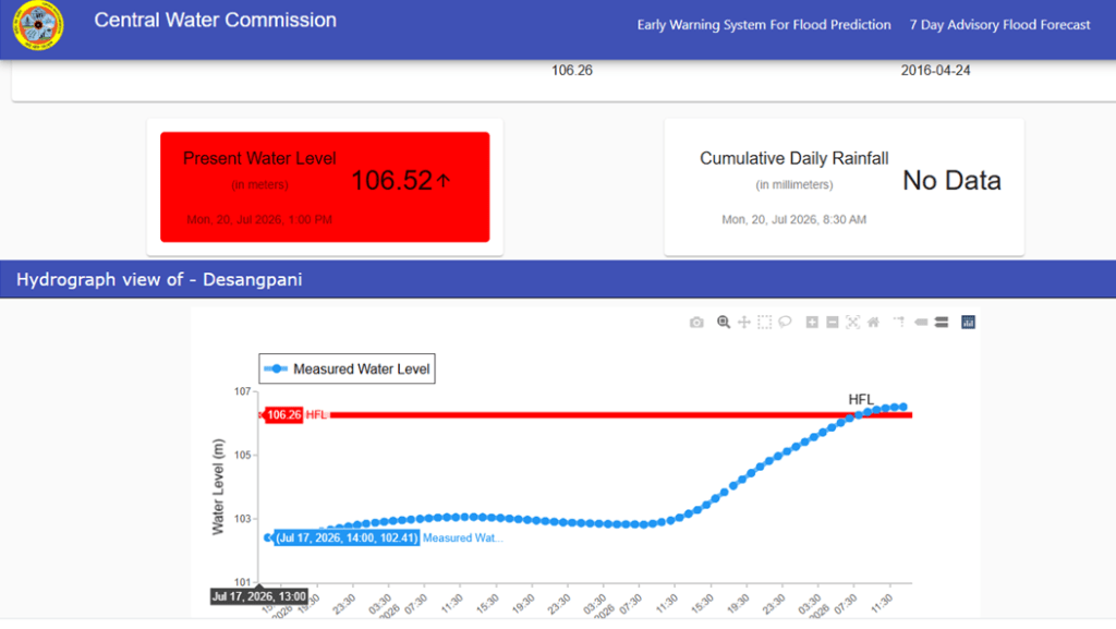
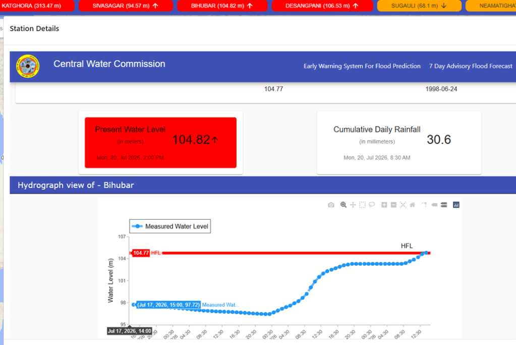
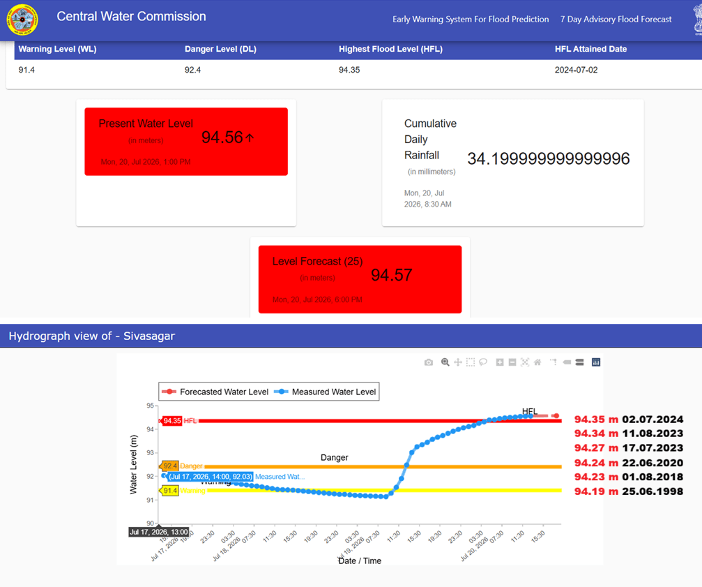
After 28 years, River Dikhow in Brahmaputra basin at Bihubar site in Sivsagar district, Assam has crossed its HFL 104.77 meter dated 24.06.1998 at 14:00 hour on 20.07.2026.
River Dikhow in Brahmaputra basin at Sivasagar site in Sivsagar district, Assam has crossed its HFL 94.34 meter dated 02.07.2024 at 05:00 hour on 20.07.2026. Present flood level is 94.56 meter and is forecasted to rise to 94.57 meter at 18:00 hour on 20.07.2026. After 2018 river has been frequently and marginally setting up new HFL at this particular site.
River Desang in Brahmaputra basin at Desangpani site in Charaideo district in Assam has breached its HFL 106.26 meter dated 24.04.2016 at 08:00 hour on 20.07.2026.
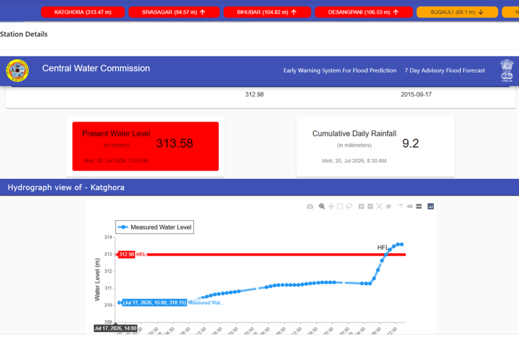
After 11 years, River Hasdeo in Mahanadi basin at Katghora site in Korba district, Chhattisgarh has breached its HFL 312.98 meter dated 17.09.2015 at 11:00 hour on 20.07.2026. Present flood level is 313.58 meter at 14:00 hour with stable trend.
URBAN FLOODS
Assam Announces ₹150 Cr Plan to End Jorabat Flooding The project, included in the Ring Road’s Detailed Project Report (DPR), will focus on improving drainage, with engineering designs to be vetted by IIT Guwahati before implementation. The announcements followed recent flash floods that inundated Jorabat, disrupted traffic on NH-27, and highlighted the need for permanent flood-management measures instead of temporary relief.
Tinsukia Opens 24×7 Control Room On 16 July 2026, the Tinsukia district administration set up a 24×7 flood control room after continuous heavy rainfall caused widespread flooding and waterlogging across the town. Several low-lying localities were inundated, disrupting road traffic, damaging homes and affecting normal life. Residents blamed the recurring urban flooding on inadequate drainage infrastructure and poor stormwater management, while authorities urged people to avoid flooded areas and report emergencies through the dedicated control room.
CLOUD BURSTS
Flash Floods Kill 11 in J&K Torrential rain triggered flash floods and landslides in Jammu & Kashmir’s Poonch and Rajouri districts, killing at least 11 people and leaving several others missing. Houses, roads and vehicles were swept away as rescue teams, the Army and disaster response agencies launched relief operations. In view of heavy rainfall and safety concerns, the Amarnath Yatra was temporarily suspended from both the Pahalgam and Baltal routes.
Cloudbursts Devastate Poonch–Rajouri Overnight cloudbursts and intense rainfall on 19–20 July 2026 triggered devastating flash floods and landslides across Poonch and Rajouri districts of Jammu & Kashmir. The disaster claimed over 20 lives, left several people missing and injured, and caused widespread destruction. Floodwaters swept away houses, vehicles, roads and bridges, damaged agricultural land and public infrastructure, and disrupted power and communication services in several areas.
Heavy Rain Hampers Rescue in Poonch–Rajouri On 20 July 2026, in Poonch and Rajouri districts, persistent heavy rainfall hampered search and rescue operations following the devastating flash floods and landslides that struck the region a day earlier. Despite adverse weather, teams from the Army, Police, SDRF, Civil Defence and local volunteers continued searching for seven missing persons, while clearing debris and assisting affected residents. At least 12 people had lost their lives in the disaster, with damaged roads, collapsed houses and disrupted connectivity complicating relief efforts and raising fears that the death toll could increase.
Cloudburst Halts Tourist Movement in Daksum A cloudburst struck the Bangidar area of Daksum on 19 July 2026, triggering a sudden rise in water levels and raising the risk of flash floods and landslides. While no casualties or property damage were reported and water levels began receding, authorities suspended tourist movement beyond Bidhard and banned trekking to Sinthantop, Choharnag, Fambar Valley and Margantop as a precaution. Officials from the civil administration, police, CRPF and line departments assessed the situation and kept vulnerable areas under close monitoring amid forecasts of heavy rainfall.
Flash Flood Blocks Kargil–Zanskar Highway On 19 July 2026, during the morning, a massive flash flood struck Batakhar Nallah on the NH-301 Kargil–Zanskar Highway in Kargil, Ladakh, sending mud, rocks and large boulders onto the road and completely blocking traffic between Kargil and Zanskar. The debris disrupted connectivity, prompting road maintenance teams to undertake clearance operations while authorities advised travellers to avoid the highway until it was reopened. The incident highlights the increasing vulnerability of Himalayan transport infrastructure to intense rainfall, flash floods and debris flows during the monsoon.
Cloudburst Damages Farmland in Kishtwar A cloudburst triggered flash floods in the Surnoo (Kiyar) area of Dachhan, damaging two cow sheds and causing extensive damage to agricultural land. No loss of human life was reported. The local administration has begun assessing the damage and deployed relief and restoration teams to the affected area.
Two cloudbursts in Anantnag district On July 11, 2026, two cloudbursts struck southern Kashmir’s Anantnag district. The cloudbursts hit the high altitudes causing intense flash floods in the low-lying areas. Residents in Shangus and Pahalgam were forced to evacuate as the Aaripath and Overa streams (nallah) overflowed with mud, silt, and debris. However, the sudden flow and force of water devastated local infrastructure.
Three Cloudbursts Hit Chamba, Lahaul Three cloudbursts struck Pangi subdivision in Chamba and Miyar Valley in Lahaul & Spiti during the early hours of 20 July 2026, triggering flash floods that washed away three bridges, including two footbridges and a temporary bridge. Roads were blocked by debris, several villages were cut off, and power and communication services were disrupted in parts of Pangi. Agricultural land, irrigation channels and other local infrastructure also suffered damage. No casualties were reported, while district authorities and the Border Roads Organisation (BRO) launched restoration and road-clearance operations.
Flash Flood Ravages ITBP Camp in Kinnaur A cloudburst on the evening of 18 July 2026 triggered a flash flood in Garge Nallah near Mastrang in Kinnaur’s Sangla Valley, causing extensive damage to the ITBP camp. Mud, boulders and debris inundated nearly two hectares of the camp, damaging stores, offices, fuel depot, officers’ mess, residential barracks, vehicles, the helipad, signal centre and about 200 metres of the camp road. Around 60 metres of the Sangla–Chitkul road under BRO was also damaged, temporarily disrupting connectivity and stranding tourists. The administration estimated losses of around ₹5 crore to ITBP, BRO and private property, while local residents assisted rescue and relief operations.
Flash Flood Closes Sangla–Chitkul Road On 18 July 2026, at around 5:00 PM, a cloudburst triggered a flash flood in Graga Nallah near Mastarang in Sangla Valley, Kinnaur district, Himachal Pradesh. The flood carried large volumes of mud and boulders onto the Sangla–Chitkul road, blocking traffic and disrupting connectivity. The debris also posed a threat to a nearby ITBP residential camp, prompting Border Roads Organisation and revenue officials to inspect the site and begin restoration work. No loss of life or damage to private property was reported.
Cloudburst Triggers Flash Flood in Kinnaur A cloudburst in Kinnaur district triggered a flash flood, sending large volumes of water, mud and debris from a local drain onto nearby roads, disrupting traffic and posing risks to residents. The sudden surge inundated road stretches with boulders and silt, affecting connectivity and prompting authorities to monitor the situation. No casualties were reported, but the incident highlighted the vulnerability of Himalayan roads and settlements to intense monsoon-induced cloudbursts and flash floods.
Flash Flood Blocks Sangla–Chitkul Road in Kinnaur A flash flood triggered by a cloudburst in the Gragae Nallah near Mastrang, Kinnaur, blocked the Sangla–Chitkul road after mud, boulders and debris were washed onto the route. Traffic was disrupted, but no casualties or major property damage were reported. The district administration advised residents and tourists to avoid travel in vulnerable areas until the road is cleared.
Flash Flood Washes Away Bridge in Kinnaur A sudden flash flood in the Tumber Khad washed away the bridge connecting Chitkul and Dumti in Himachal Pradesh’s Kinnaur district, severing road access to the strategically important border region. The bridge debris was carried into the Baspa River, disrupting connectivity for local residents as well as Army and paramilitary personnel. No casualties were reported as no one was on the bridge when the flood struck. The Border Roads Organisation (BRO) has begun assessing the damage and plans to restore the road link at the earliest.
MLA inspects flash flood-affected areas in Dari circle Local MLA Nyabi Jini Dirchi on July 10 visited the worst-affected areas in Dari circle of Leparada district to assess the extent of damages caused due to devastating flash floods triggered by a cloudburst of 28 June, and to oversee immediate relief and restoration measures. The joint survey, led by the MLA, covered the villages of Padi, Chisi, Dali, Ego Camp, Old Dari, New Dari, Zirdo, Jime and Ichi in Dari circle, all of which sustained extensive damages to residential houses, roads, public infrastructure, agricultural and horticultural lands, and other means of livelihood due to the flash floods.
DISASTERS
Himachal HC Summons Kinnaur DC Over Delay in Clearing Flood-Threatening Rivulet On 18 July 2026, the Himachal Pradesh High Court summoned the Deputy Commissioner of Kinnaur over the delay in clearing a blocked rivulet that has repeatedly threatened Lippa village with flooding. Taking suo motu cognisance of reports highlighting the formation of an artificial lake and inundation of homes due to the obstructed water channel, the court sought an explanation for the administration’s failure to undertake timely remedial measures despite the recurring risk. The High Court directed the district administration to ensure immediate restoration of the rivulet’s natural flow and submit a status report on the steps taken to safeguard the village from future flooding. The matter underscores concerns over delayed disaster mitigation and inadequate maintenance of natural drainage channels in the fragile Himalayan region.
Artificial Lake Submerges Homes in Kinnaur’s Lipa Village July 15 report mentions that the residents of Lipa village in Kinnaur district have been facing recurring flooding during the monsoon as an artificial lake forms after heavy rainfall. Floodwaters from an adjoining stream back up into the village nullah due to a blocked drainage channel, creating a temporary lake that submerges the ground floors of four to five multi-storeyed houses for several days. Residents said the water remained inside their homes for more than a week this year, causing repeated damage to property and disrupting daily life.
Western Ghats Need Climate-Sensitive Planning Citing climate scientists, the article explains that a warmer Arabian Sea, changing monsoon dynamics and the orographic effect of the Western Ghats are producing more intense short-duration rainfall events. However, the impacts are worsened by quarrying, deforestation, road cutting, hill-slope modification, hydropower projects and construction in ecologically fragile areas, which destabilise slopes and obstruct natural drainage. Experts stressed that disasters cannot be prevented by engineering solutions alone and called for climate-informed land-use planning, protection of forests and wetlands, regulation of development in high-risk zones, and stronger early warning systems to improve resilience in the Western Ghats.
LANDSLIDES
Landslides Kill 8 in Nagaland Heavy rainfall during the early hours of 20 July 2026 triggered multiple landslides in Mon district, Nagaland, burying several houses under mud and debris. The disaster claimed eight lives, including women and children, and left 12 people injured. Rescue teams recovered bodies and continued searches for possible survivors trapped under the debris. The landslides caused extensive damage to homes and disrupted normal life, prompting emergency rescue and relief operations by the district administration.
In view of the incessant rain fall across Mon District, multiple Landslide struck various parts of Mon Town on 19th July 2026. Walo ward below 42 AR Camp was severely affected and rescue operations were immediately launch, compromising of DEF Mon, SDRF Mon, 42 AR Mon, District Administration and civil societies. According to OC Mon Police station, more than 10 house were washed away and several other houses were affected, which claimed several casualties and injuries among residents.
The rescue team recovered the bodies of 4 (four) deceased, identified as Toithron, F/37 years of Chenwetnyu village; Tingyuh, M/ 16 years of Oting village; Thankhan, F/48 years of Oting village; Kenlong M/ 33 years of Pongkong village, all were residents of Defence Colony, Walo Ward. Search and rescue operations are still under way.
As per reports received as of 20th July 2026, a total of 9 houses were damaged by landslides, including 7 in Kiphire and 2 in Pungro, Retaining Walls at Tsuwong Ward, Pungro and Seyochung Village were also damage. Road Connectivity has also been affected, with road blockages along O2 Road, Pungro, Penkim – Fakim Road and road leading to Zisaji Presidency College, Kiphire.
Two Workers Killed in Rain-Triggered Landslide On 9 July 2026, two construction workers were killed and four others injured after a rain-triggered landslide struck a construction site at Lohitpur in Lohit district, Arunachal Pradesh. The landslide buried six workers under mud and debris while they were working at the site. Rescue teams from the district administration, police and disaster response agencies recovered all the trapped workers and shifted them to the Zonal General Hospital, Tezu, where Rahul Kumar (26) and Bipin Kumar (33) succumbed to their injuries, while the four injured workers were reported to be in stable condition. The incident was triggered by continuous heavy monsoon rainfall, highlighting the increasing risk of landslides at construction sites in the fragile Himalayan region during the monsoon season.
ENERGY OPTIONS
Climate Change Raises Risks for Renewable Power Systems The findings highlight the need for energy planners to integrate future climate projections into renewable energy expansion and grid planning to ensure reliable, resilient, and affordable low-carbon electricity systems.
Can India burn its way out of waste crisis? A technologically sophisticated furnace may improve combustion efficiency but it cannot solve the deeper failures that produce mixed waste in the first place. The larger danger is that India’s WTE policy is aggressively shifting from managing residual waste to formalising mixed waste disposal itself. (Shrotik Bose)
French Heatwave Shuts Nuclear Reactors A severe heatwave in France has forced the temporary shutdown or reduction of power generation at several nuclear reactors after river water temperatures rose beyond safe limits for reactor cooling. The incident has highlighted the growing vulnerability of nuclear power plants to climate change, as most reactors depend on large quantities of river water for cooling. Lower river flows and warmer water reduce cooling efficiency and increase the risk of ecological damage if heated water is discharged back into rivers.
ENVIRONMENT GOVERNANCE
CAG Flags Gaps in Chhattisgarh’s Mining Welfare Fund Spending The July 16 report highlights that a Comptroller and Auditor General (CAG) audit found serious irregularities in the utilisation of the District Mineral Foundation (DMF) funds in Chhattisgarh, which are meant for the welfare of mining-affected communities. The audit revealed that despite spending ₹4,536 crore between 2015-16 and 2022-23, 44% of mining-affected villages were excluded from DMF benefits. It also identified deficiencies in planning, project selection and implementation, with funds being diverted to works that did not directly benefit communities impacted by mining. The CAG pointed to weak monitoring, delays in project execution, poor identification of beneficiaries and non-compliance with statutory guidelines, raising concerns over transparency and accountability in the management of mining welfare funds intended to improve health, education, drinking water, livelihoods and environmental restoration in mining-affected areas.
SOUTH ASIA
Syed Akbaruddin on Indus Treaty: Pakistan’s Water Politics in full flow This article by Syed Akbaruddin, India’s former permanent representative to UN, provides a balanced perspective. It also has some right advise for Indian ministers: “Some Indian ministers have put that case more sharply, including talk of stopping flows. India should not answer Pakistan in kind. It should state its case plainly.”
China’s Medog Dam Bodes ill for India Good to see this article by Shyam Saran, former foreign secretary of India, where he does not even mention the India’s plan for Siang Upper Multipurpose project, and instead suggests that India needs to make a strong case and present it including before the UN Security Council, raising objections the way China is going forward with the dam, without basic information about the proposed dam in public domain.
Paizhen Active fault below the Medog Dam Site The recently published Chinese study identified the Paizhen Fault, which passes directly beneath the proposed construction zone. By analysing ancient lake sediments, researchers concluded that this fault has remained active since the Early Pleistocene and continued to move as recently as approximately 9,500 years ago. They also pointed to the 2017 Milin earthquake (magnitude 6.9) as evidence that the fault system remains seismically active today.
The study further observed that prolonged fault movement has left the surrounding slopes with weak cohesion and unstable geological structure. Once the reservoir is filled, these fragile slopes could become susceptible to failure, particularly if another earthquake occurs.
In the Yarlung Tsangpo region, the principal concern is not simply earthquake generation, but the cascading sequence of events that could follow. An earthquake could trigger massive landslides along the steep valley walls, temporarily blocking the river and forming natural barrier lakes. Such lakes are often unstable. Their eventual collapse can unleash catastrophic flood waves that travel rapidly downstream. Should such an event occur while the reservoir is full, the resulting flood could be significantly amplified.
An Important Paradox: Because India’s proposed SUMP would be located within the same tectonically active Himalayan belt, it too must confront many of the geological challenges now identified on the Chinese side. The lessons emerging from the Paizhen Fault study therefore apply equally to future Indian projects. In an era of increasing climate uncertainty and expanding infrastructure, regional cooperation grounded in science is no longer optional. It is essential. (By geologist Anil Kaul)
Nepal: India allows 4 Chinese companies in transmission sector In June 2026, Dept of Expenditure under Union Finance Ministry in India has granted a two-year limited period exemption to four companies with Chinese ownership or business links, allowing them to compete for Indian govt contracts related to critical electricity transmission infrastructure. The companies are TBEA Energy India, Nanjing Electric India, New Northeast Electric India and Taikai Electric (India).
India allows 550 MW additional power export from Nepal An important outcome of the 13th Meeting of the Nepal–India Joint Steering Committee (JSC) on Energy, held on 15 July 2026 in Pokhara was the decision to enhance cross-border electricity transmission capacity between Nepal and India from current 1100 MW to 1650 MW. Nepal can now export upto 1650 MW power to India. Another important decision was the increase in import (from India to Nepal) capacity from 1,000 MW to 1,400 MW through the Dhalkebar–Muzaffarpur and Dhalkebar–Sitamarhi 400 KV transmission corridors.
NHPC objects to Nepal SC ruling about free power India’s NHPC Limited is set to develop the 750 MW West Seti and the 450 MW Seti River-6 project. The NHPC Limited and Vidyut Utpadan Company Limited earlier signed a memorandum of understanding to jointly develop the 480 MW Phukot Karnali Project. But the NHPC has expressed concern over the Nepal Supreme Court’s ruling to increase the proportion of free electricity Nepal would receive from the Phukot Karnali Hydropower Project in Kalikot, dist in Karnali Province.
The government should renegotiate the agreement under which Nepal is entitled to receive only 21.9 percent free electricity from a high-return project for which Nepal had already completed preparations for construction, said the court in its ruling in the second week of May. The NHPC stated that either the government of Nepal should go for review against the court’s ruling or should provide over Rs50 billion as viable gap funding. The NHPC has warned that it will withdraw from both projects in Nepal if the government does not reconsider its request.
SANDRP
Also see: DRP 13 July 2026 & DRP 06 July 2026
Follow us on: www.facebook.com/sandrp.in; https://twitter.com/Indian_Rivers


