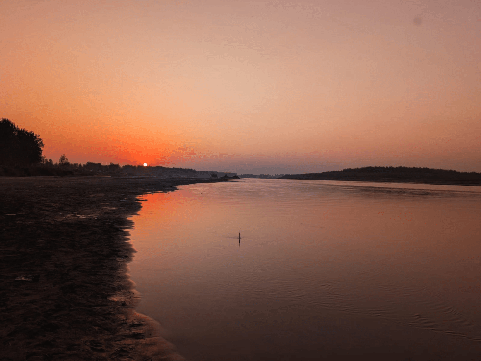
(Feature Image: River Ravi at Makora Pattan. Photo: Abhay Kanvinde)
Rivers are the most important eco-systems, providing numerous economic, environmental social and cultural benefits. And in answer to the question, who governs India’s Rivers, we are generally likely to get response blank stares. Same is the likely response about the state of India’s rivers, who monitors our Rivers and so on.
The suggestion in Punjab, of a group of experts to the state government to set up an independent River Authority for the integrated protection, restoration and management of state’s Rivers is most welcome.
The proposal seeks to improve governance of the rivers by ensuring ecological flows, regulating riverbed mining, preventing encroachments, restoring floodplains, monitoring and control pollution. The accompanying policy note warned that Punjab’s rivers face an escalating ecological crisis due to insufficient environmental flows, untreated sewage and industrial effluents, pollution from Buddha Nullah, illegal sand mining and widespread encroachments, necessitating an autonomous statutory body for sustainable river basin management.
The least it can help is trigger a debate around governance of rivers in Punjab and beyond. And possibly some initial steps towards resolving this governance vacuum around rivers.
Experts Urge Punjab Govt to Create Statutory Rivers Authority On 8 July 2026, retired Additional Chief Secretary K.B.S. Sidhu and environmental activist Col. (Retd.) Jasjit Singh Gill urged the Punjab government to enact a law establishing an independent Sutlej and Eastern Rivers Waters Authority of Punjab for the integrated protection, restoration and management of the state’s rivers. They submitted a draft legislation, “The Sutlej and Eastern Rivers Waters Authority of Punjab Bill, 2026,” to CM Bhagwant Mann, proposing a statutory authority headed by a retired Supreme Court judge or High Court Chief Justice, with experts in hydrology, ecology, water law and environmental conservation.
HYDRO POWER PROJECTS
July 2026: Flash Flood Disaster at Kwar HEP Site in Chenab Valley, J&K Though, the Kishtwar District Disaster Management Plan (DDMP) 2024-25 acknowledges the potential flood and landslide risks of hydro projects, however it appears to rely primarily on CVPPL’s Disaster Management Plan (DMP). According to the DDMP the CVPPL has its DMP ready to tackle with any disaster like situation. However, the CVPPL has yet to issue an official press release detailing the overall impact of the disaster on the project and its infrastructure.
SANDRP Flags Monitoring Gaps in Arunachal Flash Flood Disaster A report by SANDRP has attributed the severe impacts of the recent flash flood at the 600 MW Kameng Hydroelectric Project (Panyor Lower HEP) colony in Keyi Panyor district, Arunachal Pradesh, to major gaps in rainfall monitoring, flood forecasting and disaster communication. The report notes that the Central Water Commission (CWC) has only one monitoring station on the 150-km-long Panyor River, located about 40 km upstream of the project, which failed to capture the highly localised cloudburst and flash flood.
It also highlights the absence of a basin-wide early warning system, delayed public communication by district authorities, and a lack of transparency from NEEPCO regarding the incident. SANDRP further raises concerns over the project’s location in a naturally flood-prone area, the collapse of an under-construction retaining wall, and calls for an independent investigation into the engineering, ecological and disaster management aspects of the incident, with the findings made public.
Environmental Concerns Over Chenab–Beas Link Tunnel The proposed Chenab–Beas Link Tunnel Project, aimed at diverting surplus water from the Chenab basin to the Beas basin, has raised significant environmental concerns due to its location in the fragile Himalayan ecosystem. Experts warn that large-scale tunnelling through geologically unstable terrain could increase the risk of landslides, alter groundwater aquifers, affect natural springs, and disrupt riverine ecosystems. The project may also impact forests, wildlife habitats and local livelihoods while generating massive quantities of excavated debris that require safe disposal. Environmentalists have stressed the need for comprehensive geological investigations, cumulative impact assessments, and robust mitigation measures before the project proceeds, particularly given the region’s vulnerability to earthquakes and extreme weather events.
Karnataka HC Continues Stay Sharavathi PSP The Central Government informed the Karnataka High Court that a three-member expert committee constituted by the National Board for Wildlife (NBWL) and the Ministry of Environment, Forest and Climate Change (MoEFCC) has recommended against approving the proposed 2,000 MW Sharavathi Pumped Storage Project inside the Sharavathi Valley Lion-Tailed Macaque Wildlife Sanctuary.
The committee concluded that the project would fragment wildlife habitat, threaten the endangered lion-tailed macaque, require large-scale tree felling, and cause long-term ecological damage in the Western Ghats. It also found the project’s Environmental Impact Assessment (EIA) inadequate and questioned the project’s technical justification, noting that it primarily shifts electricity generation rather than creating additional power. Taking note of the report, the High Court extended its interim order restraining any on-ground project activities, while the Karnataka Power Corporation Ltd. sought time to file its objections.
The High Court observed that no work could proceed within the protected area without the approval of the NBWL. The Karnataka Power Corporation Ltd. stated that the NBWL’s final decision is still awaited, and the court continued its interim stay on project activities inside the sanctuary.
Forest clearance for dam puts white-bellied herons at risk The forest advisory committee has granted in-principle approval for a 1200- Mw Kalai II HEP in Arunachal Pradesh. The region is inhabited by the white-bellied heron, a critically endangered bird species of which only six to nine individuals are estimated to exist in Arunachal. However, the bird found no mention in the Environmental Impact Assessment prepared for the hydropower project. To compensate for the forest loss resulting from the project, the FAC approved afforestation thousands of kilometres away, in the central Indian state of Madhya Pradesh.
India’s Hydro Output sees steepest drop since Feb 2024 India’s hydropower output has dropped by more than 21% in June 2026 compared to same period last year, marking the sharpest year-on-year fall since February 2024. For the quarter ending in June, hydro generation was almost 7% down. As of July 2, reservoirs monitored by the Central Water Commission contained 47.7 billion cubic metres of water, which is 39% lower than those recorded a year earlier.
Solar now meets 24% of daytime demand, that storage could have absorbed more of it. Grid operators curtailed about 2.1 TWh of solar and wind last year to keep coal plants running — waste that roughly 10 GWh of battery storage could have averted.
DAM SAFETY
Kerala sees slow progress on Comprehensive Dam Safety Evaluation Owners of dams are required to complete the first CDSE by an independent panel of experts within five years of the commencement of the Dam Safety Act, 2021. As per this requirement, the deadline expires on December 31, 2026. But the progress in Kerala is slow.
The Kerala State Electricity Board (KSEB), which has 38 dams, has completed the CDSE on eight (as indicated by a June 25, 2026 order), while the Water Resources department, which has 22 dams, including the Aruvikkara dam managed by the Kerala Water Authority (KWA), has completed the exercise on four.
The KSEB has now sought a “detailed action plan” from its Chief Engineer (Civil-Dam Safety) within 15 days for completing the CDSE on all its dams by November 2026. The power utility is also exploring the possibility of deploying additional expert panels. In order to speed up the work, the KSEB has added two more members—an expert on hydraulic and hydrological safety and an expert on structural engineering and earthquake safety, monitoring and instrumentation—to its existing panel.
The CDSE seeks review and structural analysis of “design, construction, operation, maintenance and performance” of dams, an assessment of hydrologic and hydraulic conditions, flood control aspects and seismic safety plus an evaluation of other conditions that may threaten their structural integrity. Officials linked to the CDSE say progress on the exercise has been sluggish even at the national level. Delay by the Centre in issuing the CDSE template had caused the initial delay. Even now, there are States that have not yet started work on the evaluation, they said.
Third-Party Agency to Oversee Temghar Dam Repairs On 12 July 2026, the Maharashtra WRD announced that it will appoint an independent third-party quality-control agency to supervise repair works at Temghar Dam after persistent seepage continued despite years of remedial measures. The department floated a ₹37.5 lakh tender for the agency, which will monitor repairs on Monoliths 1–13 over a 24-month period. Officials said the dam has experienced seepage since its commissioning, with leakage increasing as reservoir levels rise. Although grouting carried out between 2017 and 2020 reduced leakage from 2,587 litres per second in 2016 to 1,252.57 litres per second in November 2025, additional repairs are required because earlier works did not fully meet technical standards in some sections.
DAMS
Expert Warns Mekedatu Project Threatens Cauvery Sanctuary Wildlife conservationist Dr. Sanjay Gubbi has warned that over 60% of the land required for the proposed Mekedatu balancing reservoir lies within the core area of the Cauvery Wildlife Sanctuary, posing a serious threat to one of southern India’s most important wildlife habitats. Speaking after the screening of his documentary Cauvery: Life in a Living River at the Mysuru Literature Festival, he said the project could permanently alter the river ecosystem, destroy habitats of rare and endangered species, and increase human–wildlife conflict by disrupting a crucial dispersal corridor for tigers and elephants between B.R. Hills and M.M. Hills. Gubbi argued that protecting the sanctuary is essential for conserving river catchments and biodiversity, and urged greater public participation in discussions on the long-term ecological impacts of the Mekedatu project.
TN Farmers Allege Karnataka Begins Mekedatu Survey The Coordination Committee of the Tamil Nadu All Farmers’ Association has alleged that Karnataka has begun survey work for the proposed Mekedatu reservoir project on the Cauvery River despite pending legal and statutory approvals. After visiting the project site near Kanakapura, the association claimed that survey markings, iron rods embedded in rocks, and newly constructed access steps indicate preparatory work for the dam. The farmers urged the Tamil Nadu government to initiate contempt proceedings against Karnataka, arguing that the project cannot proceed without approval from the Cauvery Water Management Authority (CWMA) and other statutory clearances. Karnataka, however, maintains that the project is intended to provide 4.75 tmc of drinking water to Bengaluru, generate 400 MW of hydropower, and would not adversely affect Tamil Nadu’s share of Cauvery waters.
Political Row Deepens Over Kaleshwaram Project A political confrontation has intensified in Telangana over the Kaleshwaram Lift Irrigation Project, with BRS working president K.T. Rama Rao (KTR) demanding that the Congress government immediately resume lifting Godavari water from the Kannepalli Pump House. KTR warned that deficient rainfall and El Niño conditions could trigger severe drought across much of the state and accused the government of keeping the project idle for political reasons. The Congress government rejected the allegations, stating that the Medigadda, Annaram and Sundilla barrages would remain non-operational until rehabilitation is completed and safety clearances are obtained from the National Dam Safety Authority (NDSA) and the Central Water Commission (CWC).
1. Koyna-Nivakane (Closed loop) Pumped Storage Project (2450 MW) in 312.84ha at Village Marathwadi, Tehsil Patan, Dist Satara, Mah by Adani Green Energy Ltd- Env Clearance
2. Ranavadi Pumped Storage Project (1200MW) in Pune and Raigad dist, Mah by Novarion Energy Pvt Ltd– Terms of Reference
3. Arakot Tiuni HEP (81MW) near Arakot village, Tehsil Mori, dist Uttarkashi, Uttarakhand by UJVN Limited – Terms of Reference
4. Cumulative Environmental Impact Assessment (CEIA) study reports of the Gori Ganga and Dhauliganga river basins
INTERSTATE WATER DISPUTES
Mah to get its share of water from Narmada Maharashtra will receive 10 tmcft (about 0.2295 MAF) of water from the Narmada Project following the resolution of a nearly two-decade-old inter-State issue during a meeting of four States chaired by Union Home Minister Amit Shah in New Delhi on July 7 2026. Five tmcft will come through the proposed Narmada-Tapi diversion scheme and another five tmcft will be lifted from the Ukai dam during the monsoon, when surplus water is available, to benefit North Maharashtra districts.
RIVERS

Studies Suggest Ancient Sutlej Once Fed the Saraswati River The article reviews scientific studies on the long-debated connection between the Sutlej and the ancient Saraswati River, explaining that geological, sedimentological and satellite-based research indicates the Sutlej once flowed into the Ghaggar-Hakra palaeochannel, believed by many researchers to be associated with the Vedic Saraswati. The report notes that while remote sensing, sediment dating and isotope analyses have strengthened evidence for an ancient Himalayan-fed river system, scientists continue to debate the timing, duration and exact course of the Saraswati, making it an active area of geological and archaeological research.
NGO’s Vaigai River Cleanup Halted Over Lack of Official Approval On 9 July 2026, officials of the Tamil Nadu Water Resources Department (WRD) stopped an NGO from removing water hyacinth from the Vaigai River in Madurai, stating that the organisation had begun the cleanup without obtaining prior government approval. The NGO had launched the initiative to clear the invasive aquatic weed, which has spread extensively across stretches of the river and hampers water flow, degrades water quality and affects the river ecosystem. WRD officials maintained that any desilting or vegetation removal in the river must be carried out only after official permission and technical supervision to avoid ecological and legal issues.
NGT Restrains Construction on Gomti Floodplain The NGT has directed that no construction be carried out on the riverbank or active floodplain of the Gomti River in violation of the River Ganga (Rejuvenation, Protection and Management) Authorities Order, 2016. Passing an interim order on 9 July 2026, the Tribunal issued notices to the Lucknow Development Authority (LDA) and other respondents, seeking their replies within four weeks. The order came while hearing a petition alleging that construction activities along the Gomti riverfront were proceeding without the mandatory approvals required under the 2016 Ganga protection norms. The matter has been listed for further hearing on 25 August 2026.
Haryana Plans 19 STPs to Reduce Yamuna Pollution The govt has planned the construction and upgradation of 19 STPs to curb sewage and industrial pollution. The plan includes 10 STPs with a combined treatment capacity of about 580 MLD and nine CETPs to treat industrial wastewater across multiple districts. Chief Secretary Anurag Rastogi directed officials to expedite the projects, which are estimated to cost around ₹800 crore, alongside measures such as drone mapping of drains, in-situ treatment of polluted drains, and real-time monitoring of water quality.
Cricket Match on Fly Ash Island Highlights Betwa Pollution Activists organised a symbolic cricket match on a fly ash island that has formed in the Betwa River near Parichha Thermal Power Plant in Jhansi, Uttar Pradesh, to protest the worsening pollution of the river. They alleged that fly ash discharged from the thermal power plant has accumulated in the river, creating artificial islands, degrading water quality, threatening aquatic biodiversity, and affecting farmers and communities dependent on the river. Through the unusual protest, the participants demanded immediate action to stop fly ash dumping, restore the river’s ecological health, and hold the responsible authorities accountable.
Ash Dump Threatens Parichha Dam’s Storage Capacity On 27 June 2026, Bhanu Sahay, president of the Bundelkhand State Formation Front, alleged that continuous fly ash deposition from the Parichha Thermal Power Plant has severely affected the Parichha Dam on the Betwa River, reducing its water storage capacity by nearly half. According to Sahay, the accumulation of ash has altered the river’s morphology, created large ash islands within the reservoir, and diminished the dam’s ability to store water, posing a serious threat to Bundelkhand’s future water security, irrigation and drinking water supply. He accused the thermal power plant authorities and the Irrigation Department of negligence and administrative inaction despite the worsening situation. Sahay announced that he would approach the NGT seeking accountability, action against those responsible, and restoration of the reservoir’s storage capacity.
RIVERS BIODIVERSITY
Banned Pesticide Linked to Mugger Crocodile Deaths in Rajasthan River An investigation by an NGT-appointed joint committee has found traces of the banned organochlorine pesticide Aldrin in the Chandraloi River in Kota district, Rajasthan, linking it to the deaths of mugger crocodiles. The case began in December 2024, when four protected mugger crocodiles were found dead in the river, following an earlier incident in 2022 in which around 50 crocodiles reportedly died due to industrial pollution. While the Rajasthan Forest Department acknowledged the presence of Aldrin in its response to the NGT, it denied responsibility, arguing that pesticide regulation falls under the agriculture department and pollution control agencies. The report highlights the absence of a clear investigation into the source of the banned pesticide, questions official accountability, and notes that no concrete action plan has been presented for pollution control, regular water quality monitoring or crocodile conservation. The matter is pending before the NGT.
FISH, FISHERIES, FISHERFOLKS
Fisherfolk Oppose Cuddalore Port Expansion Hearing On 7 July 2026, fisherfolk associations and environmental groups demanded the cancellation of the public hearing scheduled for the proposed Cuddalore Port expansion, alleging that the EIA was incomplete and had not been adequately shared with affected communities. They argued that the expansion project could damage coastal and marine ecosystems, alter sediment movement, intensify coastal erosion, affect mangroves and estuarine habitats, and reduce fish stocks, threatening the livelihoods of thousands of traditional fishers. Representatives of the Tamil Nadu Meenavar Peravai said the project could force fishers to venture farther into the sea, increasing operational costs and safety risks. The groups also questioned the transparency of the environmental clearance process and demanded comprehensive ecological studies and meaningful public consultation before the project proceeds.
SAND MINING
NGT Seeks Explanation for Two-Month Delay in Yamuna Illegal Mining Inspection On 7 July 2026, the NGT sought an explanation from a joint supervisory committee over a delay of more than two months in conducting an inspection into allegations of illegal sand mining along the Yamuna River in Shamli district, Uttar Pradesh. The tribunal observed that the committee had failed to comply with its earlier directions to inspect the site and submit a report within the stipulated time, raising concerns that the delay could allow continued illegal mining and further environmental degradation. The matter pertains to alleged unauthorised sand extraction from the Yamuna riverbed, which can destabilise river morphology, accelerate bank erosion, damage aquatic habitats and threaten nearby infrastructure. Expressing dissatisfaction over the lack of timely action, the NGT directed the committee to explain the reasons for the delay and proceed with the inspection and submission of its report without further postponement.
Bihar plans special force to protect officers from mining mafia As per this July 11 report, the proposal will first be discussed with Mines and Geology Minister Pramod Kumar before being submitted to the cabinet for approval. It is currently under review by the Law Department. The decision was taken at a meeting of senior department officials after several officers raised concerns over their safety and threats to their lives during operations against illegal sand mining.
More than 20 attacks on raiding teams have been reported in the last three months alone. In several instances, officers had to flee after attackers, allegedly armed with illegal weapons, opened fire during raids at unauthorised sand ghats. The official, who attended the meeting, said there had been several occasions when raiding teams did not receive adequate cooperation from local police stations, undermining special operations against illegal sand mining. The lack of adequate police support, the official said, has emboldened mining mafias, who have not hesitated to open fire on raiding teams. More than a dozen districts have been identified where illegal sand mining continues unabated.
WETLANDS, LAKES, WATER BODIES
Apex Court wading into Darbhanga Ponds Supreme Court has agreed to intervene in a case of alleged encroachment of three iconic water bodies in the Bihar town following a petition by a civil society group. The petitioners have accused the govt of posing a threat to the three water bodies – Ganga Sagar, Digghi, and Harahi, which were built by three local kings and have been around for nearly a millennium – by launching a ‘beautification’ project under the Bihar Urban Infrastructure Development Corporation (BUIDCO).
A bench of Justices Vikram Nath and Sandeep Mehta has sought an explanation from Bihar govt over the BUIDCO plan. Locals say the govt’s plan to fill parts of the ponds to construct kiosks, restaurants, and pavements is nothing but encroachment in the guise of “beautification”. Eklavya Prasad, who has worked extensively on the conservation of water bodies said “the govt is causing irreversible damage to the ponds in the name of beautification”.
Deciding to act on their concerns, a group of retired academics, environmentalists, and citizens under the banner of Talab Bachao Abhiyan (TBA) said in their plea that the filling of ponds violates orders passed by National Green Tribunal (NGT), high court, and Supreme Court itself. The petitioners want the removal of all encroachments around the ponds, and their restoration “to their original position as depicted in the maps of the years 1868 and 1960”. “Per the District Gazetteer of 1964, Darbhanga – once called the ‘city of ponds’ – had 350 ponds. The Darbhanga Nagar Nigam now puts the figure at less than 100. That means around 250 ponds have disappeared in 60 years. Now, the govt itself is filling historic ponds in violation of Wetland Rules and judicial orders. Per official records, the three ponds spread over 253 bighas, but more than 25% of the area is under encroachment,” Narayan Chaudhary, head of TBA said.
NGT Flags Severe Environmental Violations at Jhansi’s Historic Laxmi Tal On 3 July 2026, the NGT scheduled the next hearing in the case concerning the deteriorating condition of Laxmi Tal, a historic lake in Jhansi, Uttar Pradesh, after a joint committee report found serious environmental violations at the site. The committee reported untreated sewage discharge, large-scale encroachments, indiscriminate dumping of solid waste and construction debris, deterioration of water quality, and inadequate protection of the lake’s catchment area, all of which have significantly degraded the waterbody. Taking note of these findings, the NGT directed authorities to continue remedial measures and sought further progress on restoring the lake and preventing additional ecological damage. The case highlights persistent shortcomings in the conservation and management of one of Bundelkhand’s important historic urban waterbodies.
Industrial Waste Turns Shoolagiri Wetland into Toxic Dump This June 30 report mentions that the Shoolagiri wetland in Krishnagiri district has been transformed into a toxic dumping ground for industrial waste, posing a serious threat to groundwater, agriculture and the surrounding ecosystem. The report found that hazardous industrial sludge, chemical residues and solid waste have been illegally dumped across the wetland, contaminating soil and water while destroying its ecological functions. Environmentalists and local residents warned that toxic leachate from the waste could seep into groundwater aquifers, pollute nearby lakes and irrigation sources, and adversely affect agricultural lands and public health. They also criticised regulatory authorities for failing to prevent illegal dumping despite repeated complaints, and demanded immediate removal of the waste, restoration of the wetland, and strict action against those responsible for the environmental violations.
RAMSAR WETLANDS
‘Hydrology, not distance, decides Pallikaranai’s Zone of Influence’: Jayashree Vencatesan As the debate over the Zone of Influence (ZoI) around the Pallikaranai marshland intensifies, Care Earth co-founder and wetland ecologist Jayashree Vencatesan, in an interview with TNIE’s SV Krishna Chaitanya, clarified that the Integrated Management Plan never recommended a blanket one-kilometre buffer around the Ramsar site. Instead, she argues that the report called for a scientifically delineated Zone of Influence based on hydrology, drainage, biodiversity and land-use characteristics.
No Fixed 1-km Buffer Around Pallikaranai Ramsar Site, Wetland Authority Tells HC The Tamil Nadu State Wetland Authority (TNSWA) has informed the Madras High Court that there is no fixed 1-km buffer or “zone of influence” around the Pallikaranai Ramsar Site. In its affidavit, the Authority said the extent of the zone of influence cannot be uniformly prescribed and must instead be determined through a scientific assessment based on hydrology, topography, drainage patterns and surrounding land use, in accordance with the Wetlands (Conservation and Management) Rules, 2017.
It clarified that the 1-km zone shown in the draft Integrated Management Plan prepared by Care Earth Trust before the marsh received Ramsar status in 2022 was only indicative and not a final or statutory boundary. The Authority added that the National Centre for Sustainable Coastal Management is preparing a revised management plan & scientifically delineating the wetland boundary & its zone of influence. The matter to be further heard by the High Court.
CREDAI Says Ramsar Freeze Around Pallikaranai Marsh Hits One Lakh Landowners The Confederation of Real Estate Developers’ Associations of India (CREDAI), Chennai, has claimed that the Chennai Metropolitan Development Authority (CMDA)’s freeze on planning approvals within the 1-km influence zone of the Pallikaranai Marsh Ramsar Site has affected more than one lakh patta holders across South Chennai. According to CREDAI, the restrictions, imposed in October 2025 following environmental directions, have stalled housing and commercial developments, impacted real estate projects worth nearly ₹1 lakh crore, and could result in government revenue losses exceeding ₹19,000 crore. The industry body has urged the government to review the uniform buffer zone, arguing that it has created uncertainty for landowners and halted development in areas such as Velachery, Pallikaranai, Perungudi, Sholinganallur and Perumbakkam.
While developers have sought a balanced framework that protects the ecologically sensitive Ramsar wetland without disrupting livelihoods and urban growth, environmental safeguards around the marsh remain central to efforts to conserve one of Chennai’s last remaining freshwater wetlands.
Warming Loktak Lake Fish Habitat & Economy threatened Climate-driven warming and shifting monsoon patterns are projected to alter the water chemistry, threatening fish habitat and the ecological balance of Manipur’s Loktak lake. A new study finds that rohu, an indigenous carp, could lose much of its suitable habitat in Loktak Lake by the 2050s, despite a low-emissions future. The wetland, which provides over 18,000 metric tonnes of fish annually in Manipur, is also under threat from pollution, encroachment and changes to its hydrology. The study published in the journal Ecological Indicators finds that rising temperatures and shifting monsoon patterns could reduce habitat suitability for native fish species.
WATER OPTIONS
Interview with Manzoor Ahmad Wangnoo Conservationist Manzoor Ahmad Wangnoo says restoring Kashmir’s lakes and wetlands depends on partnerships between communities, government agencies and local stakeholders. Through Mission Ehsaas, Wangnoo and the Nigeen Lake Conservation Organisation have helped revive degraded water bodies, showing how community-led conservation can drive ecological restoration. Wangnoo discussed the ecological significance of Kashmir’s wetlands, the region’s beauty — and his optimism for the future.
URBAN LAKES, WETLANDS
Tamil Nadu Defends CRZ Clearance for Mamallan Reservoir The Tamil Nadu govt has defended the Coastal Regulation Zone (CRZ) clearance granted for the proposed Mamallan Reservoir Project, telling the Madras High Court that all statutory procedures were followed before approval was issued. The State argued that the project is designed to augment Chennai’s drinking water supply, improve groundwater recharge, prevent seawater intrusion and mitigate flooding, while complying with environmental safeguards. The defence came in response to petitions challenging the project on the grounds that it would damage the ecologically sensitive Kovalam–Nemmeli coastal wetland and affect biodiversity. The government maintained that the CRZ clearance was based on scientific studies and expert appraisal and sought dismissal of the petitions.
IIT Madras Finds Mamallan Reservoir Project Hydrologically Feasible On 6 July 2026, IIT Madras concluded that the proposed Mamallan (Kovalam sub-basin) Reservoir is hydrologically feasible to store 1.655 thousand million cubic feet (TMC) of rainwater, supporting the Tamil Nadu government’s plan to develop it as a new water source for the Chennai region. Spread over 17.71 sq km, the reservoir is designed to store 1.655 TMC in a single filling and provide an annual storage of 2.25 TMC. According to the study, the project could augment groundwater recharge, prevent seawater intrusion, and supply up to 170 MLD of drinking water for nearly nine months each year. The assessment, based on 31 years of rainfall data, found adequate surplus runoff to support the reservoir while maintaining environmental flows. The findings were submitted to the NGT as part of the state’s technical evaluation of the project.
Environmentalists Seek Protection for Perungulam Tank Environmentalists have urged the Tamil Nadu government to protect the biodiversity-rich Perungulam tank near Madurai, warning that the ecologically significant wetland is under increasing threat from encroachments, pollution and habitat degradation. They highlighted that the tank supports a rich diversity of resident and migratory birds, aquatic flora and fauna, and plays a vital role in groundwater recharge and local livelihoods. Conservationists called for measures such as preventing encroachments, desilting the tank scientifically, regulating waste disposal, restoring natural habitats and notifying the waterbody for stronger ecological protection to safeguard its biodiversity and ecosystem services.
URBAN WATER
Urban Water Meandering in Policy and Governance Vacuum India’s recurring urban water crises demand more than emergency responses—they require integrated policies, accountable governance, and nature-based solutions to build resilient cities for a changing climate. (Himanshu Thakkar)
How India’s Megacities Source Their Water This report examines how India’s largest cities depend on distant rivers, reservoirs and groundwater sources to meet growing urban water demand, exposing the increasing vulnerability of their water supply systems to climate change, population growth and infrastructure losses. Delhi relies mainly on the Yamuna, Ganga and Bhakra systems, with water transported hundreds of kilometres before treatment and distribution.
Mumbai receives water from a network of lakes located over 100 km away but continues to lose a significant share through leakages. Bengaluru pumps most of its water from the Cauvery River, lifting it nearly 500 metres, making it one of the world’s most energy-intensive urban water supply systems. Chennai draws water from reservoirs, desalination plants and inter-basin transfers such as the Telugu Ganga Project, while Hyderabad depends on the Krishna and Godavari rivers through long-distance pipelines.
The report highlights that despite these massive engineering systems, rapid urbanisation, declining groundwater, ageing infrastructure, high distribution losses, erratic monsoons and climate change are making water security increasingly uncertain, underscoring the need for demand management, leak reduction, wastewater reuse, rainwater harvesting and protection of water sources.
Water Pricing Is a Question of Justice, Not Economics Gurudas Nulkar argues that water pricing in India should be viewed as an issue of social justice rather than merely economics, as the country’s limited freshwater resources are under increasing stress from rapid urbanisation, population growth and climate change. Citing findings from the Jal Mulya Project, the article notes that freshwater supplied by cities is often priced far below its actual cost, making it cheaper than treating and reusing grey water. This discourages investments in water recycling and undermines the transition to a circular urban water economy. The author calls for rational water tariffs that reflect the true value of water while protecting vulnerable households through equitable pricing. He argues that appropriate pricing, coupled with incentives for wastewater reuse and conservation, is essential for ensuring sustainable and just water management in India’s increasingly water-scarce cities.
Mumbai: From drought fears to deluge within days Mumbai receives around 2,400 millimetres of rainfall annually; by no stretch of the imagination can it be called water-poor. The city’s annual swing between thirst and flooding is actually a commentary on the utilitarian imagination of water in urban India: As a resource to be extracted during the dry months and an inconvenience during the monsoon. What has virtually disappeared is the understanding of water as an integral part of ecological systems.
Mumbai’s annual cycle of scarcity and inundation is not an isolated failure but a manifestation of a planning philosophy that has come to define urbanisation across the country. Delhi faces a severe groundwater crisis, while the river Yamuna is reduced to a trickle during the dry season. Bengaluru has witnessed the destruction of hundreds of interconnected lakes even as neighbourhoods alternate between water shortages and flash floods. Chennai lurched from an acute drinking water crisis in 2019 to devastating floods within a few years.
About two decades ago, Chinese landscape architect Kongjian Yu articulated a radically different vision of urban water management — one that sought to work with nature rather than overpower it. His proposition was simple: Cities should behave like sponges rather than pipelines. Instead of treating rainwater as an inconvenience to be flushed away as quickly as possible, sponge cities seek to absorb, filter, store, and gradually release it. Parks become temporary detention basins. Wetlands are restored rather than reclaimed. Green roofs reduce runoff. Permeable pavements allow rainwater to infiltrate the ground. Urban forests slow the movement of water while improving biodiversity and reducing heat.
China’s long-term target, outlined in the 2015 Sponge City guidelines, is for more than 80 per cent of urban areas to capture and reuse at least 70 per cent of annual rainfall by 2030.
Variants of the sponge city concept exist across the world. South Korea has incorporated its principles into urban development, Singapore has integrated reservoirs, wetlands and parks into its urban fabric, while Curitiba in Brazil has preserved floodplains as public parks that safely accommodate floodwaters, breaking down the rigid divide between ecological assets and civic infrastructure. The concept of “blue-green” infrastructure is evident in Rotterdam in the Netherlands, Copenhagen in Denmark and Medellín in Colombia, while Kigali’s early efforts to strengthen groundwater resilience through flood-prevention measures have earned international recognition for Rwanda’s capital.
Places are not built apart from water; their fates are intertwined with living hydrological systems. The sooner India’s cities learn to plan with water rather than against it, the more resilient their future will be. (Kaushik Das Gupta)
Mumbai wants a copy of NYC’s Central Park. This might drown the city further
How Tokyo Built World’s Largest Underground Water Tank for Flood Protection
Mumbai Unveils ₹13,000-Cr ‘Sponge City’ Flood Mitigation Plan The Maharashtra govt has announced a ₹13,000-crore Integrated Flood Mitigation Master Plan to transform Mumbai into a “Sponge City” and reduce chronic monsoon flooding. The plan combines conventional stormwater drainage upgrades with nature-based solutions, including the restoration of wetlands, rivers and open spaces, creation of rain gardens, urban forests, permeable pavements and green infrastructure to enhance rainwater absorption and reduce surface runoff. It also proposes widening and modernising drainage networks, constructing new pumping stations, desilting rivers and drains, protecting mangroves, and improving flood forecasting and early warning systems. The initiative aims to address flooding at around 370 flood-prone locations across Mumbai while making the city more resilient to increasingly intense rainfall linked to climate change.
Mumbai asked to harvest rain to mitigate floods One hundred days’ worth of freshwater supply in volume — that’s approximately how much rainwater landed on Mumbai in the first week of July. Of the estimated 386-445 billion litres of precipitation Mumbai received within its municipal limits, an estimated 85-90% was surface runoff — between 332 and 400 billion litres washing out to sea. But only after forcing people to reckon with it on the streets first.
“Water percolation and flood prevention are two faces of the rainwater harvesting coin,” says Rashneh Pardiwala, founder-director of the Centre for Environmental Research and Education (CERE), which has installed more than two dozen RWH systems across Maharashtra, including at fire temples in Mumbai and Pune.
Every monsoon, people demand better flood management, and the govt recently came up with a Rs 13,000-crore ‘sponge city’ plan that promises to soak up rainwater through bioretention parks, detention-infiltration tanks and permeable pavements.
Delhi Plans Mandatory Water Meters on All Borewells The Delhi government is drafting a new borewell policy under which all domestic and commercial borewells will be required to install water meters. Users will be charged according to the quantity of groundwater extracted, with the data helping authorities determine future water bills and monitor groundwater use across the city. The policy is also expected to create a mechanism for regularising thousands of unauthorised borewells currently operating in Delhi. Officials said the broader objective is to address water scarcity, falling groundwater levels and weak regulation of private extraction, while linking authorised borewells to rainwater harvesting requirements as part of the city’s groundwater management strategy.
Study Finds Heavy Metal in Groundwater Near Closed Bengaluru Landfill A recent scientific study has found significant heavy metal contamination in groundwater around the closed Mavallipura landfill on the outskirts of Bengaluru, raising concerns over the long-term impacts of landfill leachate. Researchers detected elevated concentrations of lead, chromium, cadmium, nickel and iron, with several samples exceeding the permissible limits prescribed by the Bureau of Indian Standards (BIS) for drinking water. The study attributes the contamination to the continued migration of toxic leachate from the landfill despite its closure and warns of potential health risks, including kidney damage, neurological disorders and increased cancer risk. The researchers have recommended continuous groundwater monitoring, remediation measures and safe drinking water alternatives for affected communities living near the landfill.
Hyderabad tanker bookings surge Water tanker bookings through the Hyderabad Metropolitan Water Supply and Sewerage Board (HMWSSB) had risen sharply this year, with nearly 12,500 apartments using the service compared with around 4,000 apartments during the summer of last year, according to HMWSSB managing director, K Ashok Reddy. He said a high volume of tanker bookings was being recorded in certain areas even on days when it was raining.
Rapid Urban Growth Drains Groundwater in Visakhapatnam The rapid high-rise construction and urban expansion along the Yendada–Madhurawada corridor in Visakhapatnam are causing a sharp decline in groundwater levels, raising concerns over the long-term sustainability of the city’s water resources. Once known for its abundant aquifers, the corridor has witnessed an unprecedented real estate boom, with large residential townships and commercial developments increasing dependence on borewells and groundwater extraction. Residents report drying borewells, declining well yields and increasing dependence on private water tankers, while hydrogeologists warn that continued unplanned urbanisation could lead to severe water stress and even seawater intrusion into coastal aquifers.
JJM/ RURAL WATER SUPPLY
Water insecurity poses a structural risk to Viksit Bharat’s ambitions for a flourishing economy, a healthy population, and a climate-resilient nation. Water is not a future burden for India; it is a present one. Aquifers are already being exhausted. Rivers are already running low. Cities are already rationing. The 2047 horizon is just 21 years away—less time than it would take to restore depleted deep aquifers or build new inter-basin transfer infrastructure. Viksit Bharat cannot be built on empty reservoirs. The question before India’s policymakers is whether they will treat water as the strategic resource it is, and marshal the political will, institutional capacity, and financial resources to place it at the centre of national planning—or whether it will remain a ‘welfare afterthought’ until it tips into crisis. The answer will be decisive in determining whether India emerges as a water-secure nation or a water-bankrupt one. (Neeraj Singh Manhas)
El Nino & Lessons from the Meghalayan Age The Meghalayan Age is very appropriate for the time in which we are living, when human impact has resulted in drastic changes to the global climate regime. Climate change projections have indicated that dry areas will become drier and wet areas will become wetter. In other words, intensified droughts and floods are going to become more common. This will have a drastic impact on food production systems, just as it did 4,000 years ago, when the mega-drought led to the decline of ancient agrarian civilisations and heralded the birth of the Meghalayan Age.
Among the measures that the Chief Minister spoke about to tackle situations such as El Niño, he stressed the need to innovate and develop farming practices suited to Meghalaya’s unique geographical and climatic conditions. It is here that the biodiversity-rich traditional farming practices of the indigenous peoples of Meghalaya can provide a very important solution. The Chief Minister also emphasised the need for integrated measures such as water conservation, spring rejuvenation, the construction of check dams and reservoirs, and other water-retention structures to enhance long-term water security. Here, one needs to ask what has happened to the 2019 Meghalaya Water Policy. Wasn’t it designed for this very purpose? These and other questions will become increasingly important, particularly as we can expect more events like El Niño in the future. Whether the Government can tackle these challenges remains to be seen. (Bhogtoram Mawroh)
AGRICULTURE
Delay in opening Mettur water could lead to 12 lakh tonne paddy loss With uncertainty looming over the release of water from Mettur dam for taking up irrigation in delta districts, given low storage, the farmers who used to cultivate a single crop of Samba paddy, using canal water, are a worried lot, anxiously waiting for enough rain in Cauvery catchment areas for the increased inflow into Mettur dam.
The Cauvery water from Mettur dam could not be released on the customary date of June 12 this year as the storage was very low. On July 12, the water level in the dam stood at 75.83 feet (37.93 TMC) and the inflow was only 91 cusecs. Last year, on the same date, the dam was full with water level at 120 feet (93.47 TMC). Farmers solely dependent on canal water for irrigation did not take up the short-term Kuruvai crop in the hope that they could cultivate the single crop of Samba paddy. According to an estimate, around three lakh farmers take up Samba paddy cultivation in the five districts of Thanjavur, Tiruvarur, Mayiladuthurai, Nagapattinam and Tiruchy.
Distress in Tamil Nadu’s delta region All is not well in the famed ‘Granary of South India’. Between a poor southwest monsoon and lack of water in the Cauvery, crops and farmers are left high and dry. The kuruvai cultivation area in Thanjavur alone has dipped to around 89,000 acres this season from around 1,94,000 acres in the previous cultivation year. This report describes the situation on the ground.
Statistics Ministry Flags Major Gaps in India’s Agriculture Data System The Ministry of Statistics and Programme Implementation (MoSPI) has identified serious shortcomings in India’s agricultural data collection system, particularly in estimating crop acreage, production and yield. An internal review found delays, inconsistencies and inadequate field verification in data collection, raising concerns about the reliability of agricultural statistics used for policy decisions.
The report notes that weak coordination among agencies, outdated methodologies and insufficient use of technology have affected the accuracy and timeliness of data, especially at a time when policymakers need reliable information to monitor the progress of the kharif season amid uncertain monsoon conditions. The Ministry has recommended modernising data collection through greater use of digital tools, remote sensing, geospatial technologies and improved institutional coordination to strengthen evidence-based agricultural planning.
MONSOON 2026
June 2026: District wise rainfall in India’s SW Monsoon In June 2026, India received 99.5 mm rainfall, 40% below normal as per IMD. This blog provides IMD’s district wise normal and actual rainfall in June 2026.
Why Maharashtra’s Western Ghats Received Record July Rainfall The article explains that exceptionally heavy rainfall over the Western Ghats of Maharashtra between 6 and 8 July 2026 resulted from a combination of a strong offshore trough, moisture-laden westerly winds from the Arabian Sea, and the orographic effect of the Sahyadri (Western Ghats), which forced moist air to rise and produce intense rainfall. Several locations, including Lonavala, Mahabaleshwar, Tamhini, Bhira and nearby ghat areas, recorded more than 600 mm of rainfall over three consecutive 24-hour periods, with some stations logging historic July totals.
Lonavala Receives 1,290 mm Rain in 48 Hours On 8 July 2026, Lonavala recorded an extraordinary 1,290 mm of rainfall in just 48 hours, making it one of the worst-hit areas during the intense monsoon spell across Maharashtra. The torrential rain triggered landslides, flooding, overflowing streams and severe disruption to road and rail transport in the Western Ghats. Authorities closed several tourist spots, while landslides affected sections of the Mumbai–Pune railway line and disrupted traffic on the Mumbai–Pune Expressway. The report notes that the extreme rainfall has once again exposed the vulnerability of the Sahyadri region to landslides, flash floods and infrastructure disruptions, particularly during intense monsoon events, prompting authorities to urge tourists and residents to avoid high-risk areas.
India’s monsoon has weakened again after a week of good showers slashed the nationwide rainfall deficit from 40% at the end of June to 14% by July 9. The current dry phase has widened the overall nationwide shortfall to 18% on July 12, which could increase further next week.
As per this July 12 report, after a spell of widespread rain helped reduce the country’s seasonal rainfall deficit to around 14%, two consecutive days of below-normal rainfall pushed the shortfall back up to 15.8%, with weather conditions expected to remain subdued over much of the country in the coming week.
Experts Forecast Erratic but Above-Normal Northeast Monsoon for Tamil Nadu Weather experts have projected that Tamil Nadu’s 2026 northeast monsoon (October–December) is likely to be above normal but highly erratic, with rainfall expected to occur in fewer, more intense spells rather than being evenly distributed. The outlook is linked to evolving El Niño conditions, which may increase rainfall variability and the likelihood of extreme weather events, including heavy downpours and cyclones over the Bay of Bengal. Experts cautioned that while total seasonal rainfall may exceed normal levels, prolonged dry spells between intense rain events could pose challenges for agriculture, water management and flood preparedness, underscoring the need for improved reservoir operations and disaster planning.
FLOOD 2026
Heavy rain upstream boosts Yamuna levels The water levels in Yamuna stretch in Delhi rose sharply on July 12, increasing by over 2 metres, following heavy rainfall recorded in the hills upstream. This marks the first instance where the river has risen above 204m-mark after a prolonged dry period during summer months, said officials. According to officials, the river rose from 201.87m at 10pm on July 11 to 204.05m at 11am at the Old Railway Bridge — 2.18m over a 12 hour period. The Bridge at Loha Pul, near Yamuna Bazaar, acts as the standard for measuring water levels of the river in Delhi for the flood related measurements.
To be sure, these volumes of water being released from the barrage are not alarming and they just indicate the return of monsoonal flow in the river bed. Bhim Singh Rawat, coordinator of the South Asia Network on Dams, Rivers and People (SANDRP), said this is the first instance of natural flow returning to the river after the summer season. “Yamuna bed has been completely dry this summer. This will help quench the river and start the period during which Yamuna resembles a normal river. Its overexploitation in non monsoon phase just reduces it to sewage canal during the other seasons,” he said.
A Village Uprooted by Floods Starts A Forest to Prevent Floods After repeated floods forced the residents of Maanpur Khurd in Uttar Pradesh to relocate, the community has begun transforming its abandoned settlement into a heritage forest. The initiative aims to restore degraded land, improve local ecology, conserve water, and reduce future flood risks through the planting of around 1,000 trees. (Bharat Dogra)
Floodwaters Sweep Over 1,000 LPG Cylinders into Patalganga River On 9 July 2026, authorities continued a large-scale search operation after more than 1,000 LPG cylinders were swept into the Patalganga River from an HP Gas bottling plant in Rasayani MIDC, Raigad district, following intense monsoon rains. The cylinders were washed away after heavy rainfall inundated a natural drainage channel passing through the plant, allowing floodwaters to carry away a substantial number of the over 2,000 cylinders stored at the facility. The incident underscores the vulnerability of industrial facilities located in flood-prone areas to extreme monsoon events. A local gas leak expert and volunteer, Dhananjay Geedh, said, “A suspected cloudburst resulted in a flash flood within 10-15 minutes. The company premises were under 7 feet of water while floating cylinders moved through the channel and truck yard gate towards the river.”
Google Earth image showing the HP Gas Bottling Plant (yellow square) in Rasayani MIDC, Raigad, from where more than 2,000 LPG cylinders were swept into the Patalganga River through a local stream following an intense rainfall event on July 8, 2026. The resulting flash flood in the local stream also inundated the bottling plant premises. The image further marks permanent residential building complexes (yellow circles) located close to both the Patalganga River and the local stream.
HFL BREACH
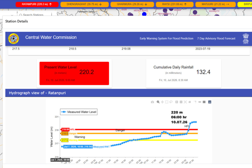
River Kali a tributary of Hindon in upper Yamuna basin has crossed its old HFL 219.08 meter dated 19.07.2023 at 06:00 hour on 10.07.2026. Present flood level is 220.2 meter at 09:00 am on 10.07.2026 with stable trend.
URBAN FLOODS
Bombay HC: Encroachments, Blocked Drains Behind Mumbai’s Waterlogging The Bombay High Court on July 07 observed that Mumbai’s recurring monsoon waterlogging is not solely the responsibility of the Brihanmumbai Municipal Corporation (BMC), but is also the result of rampant encroachments, blocked drains and misuse of public infrastructure by citizens. Hearing a case related to road widening in Mandala village on the Sion–Trombay Road, a bench of Acting Chief Justice Ravindra Ghuge and Justice Gautam Ankhad remarked that people occupy public land, clog drainage lines, convert footpaths into parking spaces and commercial stalls, and then blame civic authorities for flooding. The Court directed the Department of Atomic Energy (DAE) to decide whether it would provide the additional land required for widening the road from 30 ft to 50 ft. The matter has been posted for further hearing in the last week of July.
Why Gurugram Floods Every Monsoon The article argues that poor urban planning, not heavy rainfall alone, is the primary reason for Gurugram’s recurring floods. It explains that rapid urbanisation has replaced natural wetlands, ponds and open land with concrete surfaces, drastically reducing the city’s ability to absorb rainwater. Encroachment and blockage of natural drainage channels, inadequate stormwater drainage infrastructure, and unregulated construction in low-lying areas have further aggravated waterlogging. As a result, even moderate rainfall overwhelms the city’s drainage system, leading to inundated roads, traffic paralysis, power outages and disruption of daily life. The report stresses that restoring natural water bodies and drainage networks, along with better urban planning and drainage management, is essential to address Gurugram’s chronic flooding problem.
Gurgaon Commissions ₹105-Cr SWD On 6 July 2026, the Gurugram Metropolitan Development Authority (GMDA) announced the commissioning of the ₹105-crore, 4.3-km Leg-4 stormwater drain, designed to reduce chronic monsoon flooding in Gurugram. Running from Vatika Chowk to Sector 37D parallel to NH-48, the new drain diverts excess rainwater away from the overburdened Badshahpur drain, the city’s main stormwater channel, before rejoining it downstream. The project aims to reduce waterlogging at major flood-prone locations such as Hero Honda Chowk, Rajiv Chowk and stretches of NH-48, where intense rainfall, rapid runoff from the Aravalli foothills, rapid urbanisation, and the limited carrying capacity of existing drainage infrastructure have led to recurring flooding. The new drain, equipped with a gate-controlled diversion system, is expected to improve stormwater management, ease traffic disruptions during the monsoon, and strengthen the city’s flood resilience as part of GMDA’s broader drainage improvement strategy.
CLOUD BURSTS
Cloudburst Triggers Flash Floods in Pahalgam A cloudburst on the evening of 12 July 2026 triggered flash floods along the Overa Stream in the Awoora area of Pahalgam, inundating several hotels, tourist huts and residential buildings. The overflowing stream damaged a stretch of the Pahalgam–Awoora–Bijbehara road, disrupted electricity and drinking water supply, and affected orchards and agricultural land across nearly 11 villages. Authorities evacuated tourists to safer locations, and no casualties were reported. Restoration work was launched immediately to clear debris and repair damaged infrastructure.
Pahalgam has experienced similar extreme weather events in the past. In July 2022, a cloudburst struck the Baltal–Pahalgam route of the Amarnath Yatra, causing flash floods and highlighting the region’s vulnerability to sudden, high-intensity rainfall. The latest incident has renewed concerns over increasing cloudburst frequency and the need for stronger early warning systems and disaster preparedness in the Kashmir Himalaya.
The report highlights that hotels and tourist facilities built along the natural stream have narrowed flood channels, altered drainage patterns and encroached upon the eco-sensitive zone, increasing the destructive force of flash floods. Conservationists warned that the sanctuary forms a critical wildlife corridor for the endangered Hangul, Himalayan brown bear and musk deer, and urged stricter enforcement of land-use regulations to protect the fragile ecosystem from further degradation.
Cloudburst in Chittergul Damages Homes, Farmland A cloudburst on the evening of 12 July 2026 triggered a flash flood in Chittergul village of Anantnag district, sending torrents of water, mud and boulders through the area. Several houses were damaged, agricultural land and orchards were inundated, roads and irrigation channels were affected, and residents suffered significant property losses. There were no reports of loss of life, but many families demanded compensation and immediate restoration of damaged infrastructure. Local authorities assessed the damage and initiated relief measures.
Residents said Chittergul and nearby areas have experienced recurrent flash floods and cloudburst-related damage in recent years, with increasing frequency of extreme rainfall events causing losses to homes, roads and farmland. The latest incident has renewed demands for permanent flood protection works, improved drainage and timely compensation for affected families.
Cloudburst Triggers Flash Floods, Widespread Damage in Thathri On 8 July 2026, a cloudburst accompanied by torrential rainfall triggered devastating flash floods in Thathri town of Doda district, Jammu & Kashmir, causing widespread destruction to homes, shops, roads and public infrastructure. Preliminary reports indicated that at least 14 houses, 16 shops, one private school and around 20 vehicles were completely damaged, while several other residential and commercial buildings suffered partial damage. Floodwaters carrying mud, boulders and debris blocked roads, disrupted traffic & normal life, & damaged sections of the Doda–Kishtwar highway.
Thathri has witnessed similar devastation in the past. In 2017, a cloudburst-triggered flash flood claimed six lives and caused widespread destruction, underscoring the region’s vulnerability to extreme weather events during the monsoon season. Officials said the damage assessment is still underway and the extent of losses may be revised after the completion of field surveys.
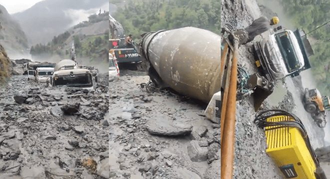
Cloudbursts Trigger Flash Floods at Kwar HEP, Block NH-244 Two cloudbursts and heavy rainfall triggered flash floods and landslides in Doda and Kishtwar districts of Jammu & Kashmir during the early hours of 6 July. Around 4 a.m., a cloudburst at Prem Nagar deposited huge quantities of mud, boulders and debris on the Batote–Doda–Kishtwar Highway (NH-244), damaging a section of the road, burying around a dozen vehicles and disrupting traffic for over eight hours. Road restoration began around 9 a.m. and the highway was reopened by 1 p.m.
In Kishtwar district, flash floods and mudslides struck the under-construction 540 MW Kwar Hydroelectric Project, inundating the tunnel area with mud and boulders. Several dumpers, dozers and other construction vehicles were buried or damaged, construction materials were washed away, & the approach road to the project site was damaged before being restored later in the day.
12 Cloudbursts in 12 Hours Raise Fresh Alarm Over Himalayan Disaster Risk in J&K A. Experts attribute the rising risk to a combination of climate change, warming temperatures, erratic monsoon behaviour, fragile Himalayan geology and increasing human interventions such as hydropower development, road expansion and hill cutting. Scientists have stressed the need for improved rainfall monitoring, early warning systems, resilient infrastructure and stricter regulation of development activities in ecologically sensitive Himalayan regions.
Flash Flood in Mandi Washes Away Bridge A cloudburst in the Janjehli area of Mandi district at around 5:00 a.m. on 10 July 2026 triggered a flash flood, causing widespread damage. The flood washed away a bridge, several houses and cowsheds, while roads and agricultural land were also damaged. Debris and floodwaters disrupted connectivity and affected normal life in the area. Rescue and restoration teams were deployed to assess the damage and clear blocked roads. The incident occurred amid continued heavy rainfall across Himachal Pradesh, with the India Meteorological Department (IMD) issuing warnings of more rain and the possibility of further flash floods and landslides over the following days.
Cloudburst Triggers Flash Flood in Kullu On 8 July 2026, a cloudburst in the upper reaches of the Garsa Shilanala area triggered a sudden flash flood in the Garsa Khad in Kullu district, Himachal Pradesh. The surge in water level washed away one to two culverts (small bridges), disrupting local connectivity and creating panic among residents living along the stream. The incident is part of a series of recurring cloudburst and flash flood events in Kullu, a region highly vulnerable to extreme rainfall, as demonstrated by similar disasters in 2024 and 2025 that caused significant damage to roads, bridges and settlements.
Cloudburst in Gadsa valley Kullu A cloudburst in the Gadsa Valley of Kullu district on the evening of 7 July 2026, coupled with continuous heavy rainfall, caused a sharp rise in the Beas River. As inflows increased, authorities opened all five spillway gates of the Pandoh Dam in Mandi district to release excess water and issued alerts to people living along the river downstream. The high sediment load and floodwaters forced the shutdown of the Dehar Power House, while authorities advised residents and tourists to stay away from the Beas River.
Flash Flood Washes Away Temporary Bridge in Samej Khad At around 4:00 a.m. on 7 July 2026, a cloudburst over the Jot hills above Naged village in Nirmand block of Kullu district triggered a flash flood in Samej Khad. The flood washed away a temporary Bailey bridge that had been installed after the devastating July 2024 disaster, once again disrupting road connectivity to Samej and nearby villages. Rising water levels and debris also damaged the approach road, while another cloudburst in the Garsa Valley caused flooding in the area. The incident has revived concerns over the recurring flash floods and cloudbursts in the Samej Khad catchment, which suffered extensive loss of life and infrastructure during the 2024 monsoon disaster.
Cloudburst Washes Away Roads in Shimla’s Barandali Khadd On 8 July 2026, a cloudburst over Barandali Khadd in the Chopal subdivision of Shimla district triggered a sudden surge of water and debris, washing away roads and severely disrupting connectivity in the area. The flash flood damaged road stretches, cut off access to several villages, and posed a threat to nearby houses and public infrastructure.
Cloudburst Triggers Flash Flood Scare in Kasheri Drain, Kullu On 8 July 2026, an early morning cloudburst in the upper catchment of the Kasheri Drain (Kasheri Nallah) in the Patlikuhal area of Kullu district triggered a sudden flash flood, causing panic among residents living along the drain. The strong surge of water and debris raised fears of damage to nearby settlements and infrastructure, prompting the local administration to issue warnings asking people to stay away from rivers, streams and low-lying areas.
Cloudburst Triggers Flash Flood in Rampur A cloudburst over Brandli Khad during the night of 5–6 Jul 2026 triggered a flash flood that caused widespread damage in Narain and Paljara panchayats of Rampur subdivision in Shimla district. The flood damaged a playground, cremation ground, footbridge, crate wall and several link roads, while large quantities of debris and silt were deposited on agricultural fields. Road connectivity to Pei, Ginchha & Shingral villages was cut off.
Third Cloudburst in a Week Hits Rampur The event marked the third cloudburst in the Rampur region within a week, highlighting the increasing frequency of extreme rainfall and flash floods in the fragile Himalayan terrain of Himachal Pradesh. The earlier two incidents were:
2 July 2026 – Saran village, Sarpara Gram Panchayat, Rampur subdivision, Shimla district: A cloudburst triggered a flash flood that washed away agricultural land, damaged irrigation channels, footpaths and rural roads, disrupting access for local residents. No casualties were reported.
3 July 2026 – Dattnagar area, Rampur subdivision, Shimla district: Another cloudburst caused a sudden surge in local streams, damaging roads, retaining walls and public infrastructure, while depositing large quantities of debris that disrupted connectivity and threatened nearby settlements. Authorities deployed teams to restore access and assess losses.
These back-to-back incidents, followed by the 5–6 July 2026 Brandli Khadd cloudburst, underscore the increasing frequency of localized extreme rainfall and flash floods in the Rampur region during the current monsoon.
Study Explains Rare Weather Pattern Behind Himachal’s 2023 Disaster A new international study has concluded that the devastating floods, cloudbursts and landslides in Himachal Pradesh during July 2023 were caused not by the southwest monsoon alone, but by a rare interaction of multiple weather systems. According to the research, after 9 July 2023, moisture supply from the Bay of Bengal weakened significantly, while an unusually strong flow of moisture from the Arabian Sea, combined with a Western Disturbance, a low-pressure system over southwest Rajasthan, and active monsoon circulation, produced record-breaking rainfall across northwest India. The study, published in the journal Meteorology and Atmospheric Physics, found that the Western Disturbance remained nearly stationary between 7 and 10 July, prolonging heavy rainfall and triggering widespread floods and landslides. Scientists say these findings can improve impact-based weather forecasting and disaster preparedness in the Himalayan region. The 2023 disaster claimed over 450 lives in Himachal Pradesh and caused losses exceeding ₹13,000 crore.
Fresh floods, landslides disrupt normal life in Arunachal Fresh floods and landslides triggered by incessant rain disrupted road connectivity and damaged public infrastructure in several districts of Arunachal Pradesh on July 13, an official statement said. The toll in the ongoing deluge in the state remained at seven, while over 97,000 people were affected, it said.
The State Emergency Operation Centre (SEOC) said heavy rainfall in the upper reaches of the Kumey River early on Monday triggered flash floods in Kurung Kumey district, causing extensive damage in Parsi-Parlo circle and Damin subdivision. In Damin subdivision, a bridge connecting Huri and Damin was washed away, snapping road connectivity. In Parsi-Parlo circle, the Inspection Bungalow was inundated, two residential houses suffered partial damage, a church was damaged and a bridge connecting Pagam village was washed away, the statement said.
The floods also caused extensive damage to St Thomas School, a prominent educational institution in the area. The entire campus was submerged, damaging buildings, classrooms, teaching materials, furniture, equipment and teachers’ quarters, it said, adding that academic activities have been halted. The flash floods severely affected transportation, public infrastructure and residential properties.
HIMALAYAN DISASTERS
Flooding Under the Scorching Sun: The Unstudied Crisis of Himalayan Nallahs Parineeta Dandekar writes on the strange phenomenon of Himalayan Nallahs flooding catastrophically in the absence of rain, snow or clouds. And when the Nallahs flow, they bring such ferocious floods with silt that roads, bridges and connectivity breaks down for hundreds of people in several villages for weeks, bringing such losses and misery for them. This has been happening for at least five years. She visited the Jahlma Nallah and people there three years ago and thought and wrote, may be this is a unique phenomenon.
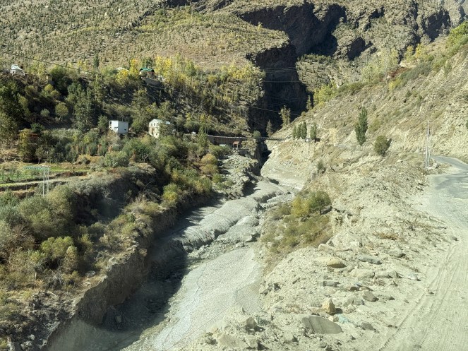
But further research and discussion with the affected people and experts at IIT and elsewhere brought to light here that this is happening at several Nallahs (Streams). But no where in the world this seems has serious as in Indian Himalayas. But this needs URGENT studies and solutions. But there seems little seriousness from the government so far. Please share if you know of more such examples.
Valley Blocking landslide in Lower Siang district, Arunachal Pradesh In this blog, David Petley writes: On Monday 29 June 2026, a valley-blocking landslide occurred on the Siji River in Lower Siang district, Arunachal Pradesh, India. The location is in the region of [27.7146, 94.69135]. Fortunately, reports indicate that the landslide has already started to release water, so this is unlikely to pose a long term risk. The trigger has been very heavy early monsoon rainfall. But the Google Earth imagery of the area also shows massive disturbance of the slopes in this area from quarrying. there has been widespread flooding and landslides across Lower Siang, reportedly affecting 3,100 people across 14 communities.
NHIDCL Targets October Bids for Two Strategic Kashmir–Chenab Valley Tunnels On 9 July 2026, the National Highways and Infrastructure Development Corporation Ltd. (NHIDCL) announced that it plans to invite bids by October 2026 for the construction of two strategic all-weather road tunnels—the 38.61-km Singhpora–Vailoo Tunnel connecting Anantnag with Kishtwar, and the 12.85-km Sudhmahadev–Dranga Tunnel linking Udhampur with Doda in the Chenab Valley. The two projects, approved by the Centre in April 2026 at an estimated cost of ₹9,779.42 crore, aim to provide year-round connectivity by bypassing snow-bound mountain passes and landslide-prone stretches on National Highway-244.
NHIDCL officials said the projects are expected to significantly reduce travel time, improve connectivity between Kashmir and the Chenab Valley, enhance disaster resilience, facilitate tourism, and strengthen strategic and economic links in the region. The Singhpora–Vailoo project had earlier been delayed after a 2024 tender was scrapped due to security clearance issues involving the lowest bidder, but the projects have now been revived and are moving towards the bidding stage.
LANDSLIDES
Kerala Halts Wayanad Twin Tunnel Project After Fatal Landslide The Kerala government has suspended construction of the ₹2,400-crore Anakkampoyil–Kalladi–Meppadi twin tunnel project following the fatal landslide at the tunnel entrance near Meppadi in Wayanad district on 7 July 2026. The incident claimed three migrant workers’ lives, while five others remained missing and rescue operations continued. The government ordered separate legal and technical investigations to examine the cause of the landslide and whether the construction company complied with environmental clearance conditions. CM V.D. Satheesan said work on the project would resume only after assessing all vulnerable factors and ensuring the safety of the site. Construction of the twin tunnels, connecting Meppadi (Wayanad) and Anakkampoyil (Kozhikode), began last year and had progressed from both ends.
Tunnel company directed to compensate victims’ families: Minister Siddique The company executing the tunnel project at Kalladi has been directed to provide immediate as well as long-term financial assistance to the families of those killed and injured in the July 7 landslide, Kerala Agriculture Minister T Siddique said on July 12. Speaking at a review meeting held at the Collectorate, Siddique said the company had also been instructed to remove the earth that collapsed during the landslide and the soil dumped at the site as part of the tunnel work within three days. The minister said an expert committee would arrive in the district to inspect the accident site. He said the panel would examine the area and submit a report on how, when, from where, and in what manner the accumulated earth should be removed, and recommend safety measures.
Emergency workers on July 12 recovered the body of the lone missing person following a devastating debris slip at a tunnel construction site at Kalladi in Wayanad’s Meppadi, taking the death toll in the disaster to eight. The deceased was identified as Bikram Singh Rana, a project manager from Himachal Pradesh.
Kerala Orders Twin Probes into Wayanad Tunnel Landslide On 9 July 2026, the Kerala government ordered two separate investigations into the fatal landslide at the under-construction Anakkampoyil–Kalladi–Meppadi twin-tunnel project in Kalladi, Wayanad district, after the disaster claimed three workers’ lives and left five others missing. The state suspended construction work until the inquiry reports are submitted. One probe will examine the technical causes of the landslide, while the other will investigate whether the executing agency complied with the environmental clearance conditions and other statutory requirements. Rescue operations continued despite persistent heavy rainfall and unstable terrain. State Agriculture Minister T. Siddique described the incident as a “man-made disaster”, alleging that unscientific dumping of excavated earth near the construction site may have contributed to the slope failure, although the construction company denied responsibility.
Contractor Rejects ‘Man-Made’ Claim The decision follows a note submitted by the project’s contractor, Dilip Buildcon, denying negligence and attributing the landslide to exceptionally heavy rainfall and the fragile terrain, while maintaining that all engineering, safety and environmental norms had been followed. Earlier, Kerala ministers had termed the incident a “man-made disaster”, alleging that unscientific dumping of excavated muck and failure to address drainage issues contributed to the landslide. The disaster claimed three lives, left five workers missing, and prompted the government to order legal and technical investigations before fixing responsibility.
Kerala HC to hear suo motu proceedings on July 2024 landslide in Wayanad The Kerala High Court will on July 10, 2026 take up for hearing the suo motu proceedings regarding the July 2024 landslide in Wayanad in which over 230 people died. The proceedings had been initiated in August 2024, when cases connected with quarrying and construction activities in Wayanad came up for hearing. The High Court had then said that the State government should first evolve a comprehensive policy on the developmental activities that could be permitted in different areas of the State.
EDIT: Wayanad Landslide Calls for Rethinking Development in Fragile Hills The editorial argues that the 7 July 2026 landslide at the Anakkampoyil–Kalladi–Meppadi twin tunnel project in Wayanad, Kerala, should be treated as a warning against pursuing large infrastructure projects in ecologically fragile mountain regions without rigorous environmental safeguards. It notes that while the exact cause of the landslide is under investigation, allegations of unscientific dumping of excavated muck, inadequate drainage management and poor compliance with environmental conditions raise serious concerns.
The editorial stresses that climate change is increasing the frequency of extreme rainfall events, making vulnerable landscapes such as the Western Ghats even more susceptible to landslides. It calls for transparent scientific investigations, strict enforcement of environmental regulations, cumulative impact assessments, and development planning that prioritises ecological stability and public safety over engineering expediency.
Warning from Western Ghats Protecting the Western Ghats does not require halting development. It requires recognising that ecological security is the foundation of sustainable growth. Scientific land-use planning, strict regulation of construction, tourism based on carrying-capacity assessments, restoration of degraded forests, and timely implementation of expert recommendations can substantially reduce the risk.
Local Biodiversity Management Committees must be empowered to play a meaningful role in landuse decisions, while infrastructure projects should adopt climate-resilient engineering practices. An empowered inter-state Western Ghats Ecology Authority could co-ordinate conservation efforts, regulate major land-use changes, and strengthen disaster preparedness across the mountain range. Karnataka cannot afford to wait for another Wayanad or another Kodagu before acting. Nature has warned us more than once; ignoring it invites an even harsher reckoning.
ENVIRONMENT GOVERNANCE
India Ranks second from lowest in the latest Environment Performance Index The Environmental Performance Index (EPI) is a biennial scorecard developed by researchers at Yale and Columbia Universities. It evaluates and numerically ranks the sustainability of countries worldwide based on environmental health, ecosystem vitality, and climate change mitigation. India has an overall EPI score of 22.46 (on a range of 0 to 100). In contrast, the best performing country, Estonia, has an EPI score of 74.79. India also had the lowest regional ranking (eight), among eight south Asian countries. The last EPI (in 2024) ranked India at 176 among 180 countries. Previously, EPI 2022 ranked India at 180, at the very bottom.
In the most recent EPI rankings (published in 2026), Estonia secured the top position, followed by Luxembourg and the United Kingdom. Conversely, India ranked 176th out of 177 countries, scoring 22.46 out of 100. India finished second from the bottom, just ahead of Laos, due to significant challenges with air pollution, coal dependence, and weak biodiversity protection.
Conservationists Challenge NBWL’s Functioning in Delhi HC A group of retired Indian Forest Service officers, conservationists and wildlife experts has filed a public interest litigation (PIL) in the Delhi High Court challenging the functioning of the National Board for Wildlife (NBWL) and its Standing Committee. The petition alleges that the statutory body, established to safeguard wildlife and protected areas, has increasingly acted as a “clearing house” by routinely approving projects in national parks, wildlife sanctuaries, tiger reserves and eco-sensitive zones without adequate scientific scrutiny or compliance with the Wild Life (Protection) Act, 1972. The petitioners have sought judicial directions to ensure transparent, science-based decision-making, proper appraisal of projects affecting wildlife habitats, and strict adherence to the Board’s statutory conservation mandate. The High Court has issued notice to the Centre and sought its response.
Four Aides to Environment Minister Removed On 7 July 2026, the MoEFCC removed four members of Union Environment Minister Bhupender Yadav’s personal staff through separate orders issued on 3 July 2026. Private Secretary Amar Singh (IRS) was repatriated to the Department of Revenue on “administrative grounds”, Assistant Private Secretary Siddharth Yadav and Additional Private Secretary Ayush Saran had their appointments terminated with immediate effect, while Additional Private Secretary Shailesh Kumar Singh was prematurely repatriated to the Department of Personnel and Training with an extended cooling-off period. The ministry did not disclose any reasons for the unprecedented simultaneous removal of four senior aides.
SOUTH ASIA
China’s Medog dam sits atop an active fault line A study by geologists affiliated with China’s state-run geological survey has found that the under-construction Medog Hydropower Station in Tibet sits atop an active fault line. According to a report by the South China Morning Post, citing a paper published in Mandarin in the journal Sedimentary Geology and Tethyan Geology under the supervision of the state-owned China Geological Survey, researchers identified the active Paizhen Fault directly beneath the Medog dam site on the Yarlung Tsangpo.
The study, which was conducted by geologists from the Chengdu University of Technology, the Civil-Military Integration Centre of the China Geological Survey, and the Middle Yarlung Zangbo River Natural Resources Observation and Research Station, has warned that this fault could significantly undermine the structural stability of the mega-dam. The researchers said the Paizhen Fault, which has remained active since the Pleistocene epoch—the geological period that began about 2.6 million years ago and included the Ice Age—poses a significant risk to the mega-dam because it continues to show signs of tectonic activity.
Researchers also noted that the Pai village area, where the Medog dam is being built, lies within one of China’s most earthquake-prone regions. Ancient lake sediments indicate the fault was active as recently as 9,500 years ago, while the magnitude 6.9 earthquake that struck Tibet in 2017 at the northern end of the fault provided further evidence of its continuing seismic potential.
The study said repeated movement along the fault has already damaged the underlying geology. “This makes the foundation bearing capacity and structural stability of nearby engineering projects more susceptible to damage,” the researchers wrote, explaining that the fault has fractured surrounding rocks and weakened their mechanical properties. In practical terms, this means the ground beneath the project is less capable of supporting the immense weight of a 60,000 MW dam and its water reservoir.
Bangladesh, China Advance Teesta River Project During Bangladesh Prime Minister Tarique Rahman’s visit to China, the two countries signed an agreement to accelerate a feasibility study for the Teesta River Comprehensive Management and Restoration Project (TRCMRP). The proposed project aims to reshape the Teesta’s catchment in Bangladesh through river engineering, embankments and other infrastructure. The development is being closely watched in India because parts of the project lie close to the strategically important Siliguri Corridor (Chicken’s Neck). The project, first proposed in 2020, had remained stalled under the previous Sheikh Hasina government amid India’s concerns over Chinese involvement. Analysts say the latest agreement reflects growing China-Bangladesh strategic cooperation and could expand Beijing’s footprint in a region of significant geopolitical sensitivity, while the long-pending India-Bangladesh Teesta water-sharing dispute remains unresolved.
Pakistan: Neelum Jhelum HEP to remain inoperative till March 2028 The over Rs 500 billion Neelum-Jhelum Hydropower Project (NJHPP), shut since a tunnel collapse on April 2, 2024, may resume power generation by March 2028, nearly four years after its closure. This was disclosed to a parliamentary committee on July 10 by Water and Power Development Authority (Wapda) Chairman retired Lt Gen Muhammad Saeed, who also reported a Rs23bn loss caused by a fake bank guarantee submitted by the defaulting contractor of the Nai Gaj Dam project in Sindh.
THE REST OF THE WORLD
NASA Uses Satellites to Track Harmful Algal Blooms in Blue Mesa Reservoir Published on 6 July 2026, NASA’s Earth Observatory highlighted how satellite observations are helping scientists monitor harmful cyanobacterial (blue-green algae) blooms in Colorado’s Blue Mesa Reservoir, one of the largest reservoirs in the United States. Research by the U.S. Geological Survey (USGS) and the National Park Service found a strong link between low reservoir water levels, warmer water temperatures, and the occurrence of harmful algal blooms, particularly during the severe drought years of 2021 and 2022, when the reservoir reached its lowest level since 1984. With drought conditions and below-average water storage persisting in 2026, scientists expect similar bloom risks.
NASA explained that satellite-based tools using Landsat and Sentinel-2 imagery, along with the WaterMAP, STREAM, and Cyanobacteria Assessment Network (CyAN) platforms, enable rapid identification of potential bloom hotspots, allowing authorities to prioritize field sampling and water quality testing. The report emphasizes that while satellites provide an efficient early-warning system, on-site monitoring remains essential to confirm the presence and toxicity of algal blooms.
SANDRP
Also see: DRP 06 July 2026 & DRP 29 June 2026
Follow us on: www.facebook.com/sandrp.in; https://twitter.com/Indian_Rivers


