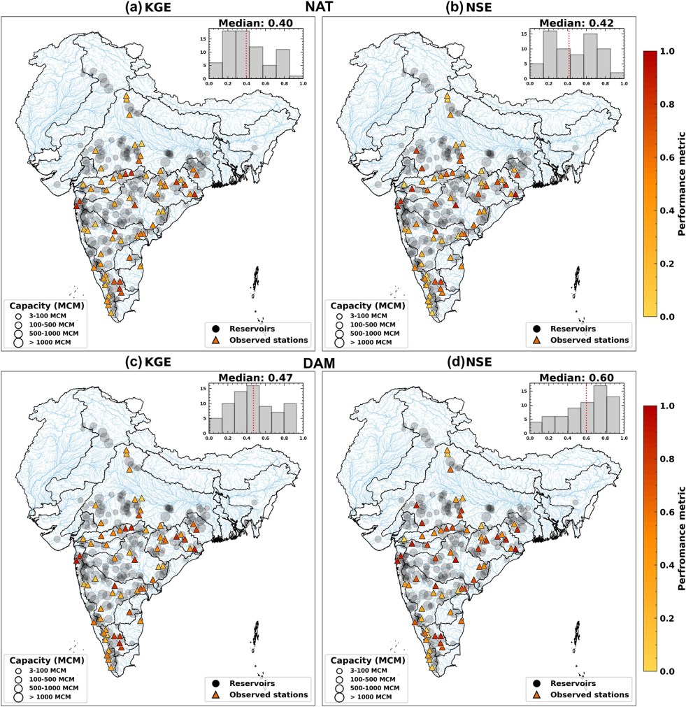
(Feature Image: Model performance computed across 71 stations (a) NAT-KGE: median 0.4 (b) NAT-NSE: median 0.42 (c) DAM-KGE: median 0.47 (d) DAM-NSE: median 0.60. Source: AGU)
A new study has again emphasized on why dam operations in India need to move from routine schedules to weather forecast based management. The study analyzed 223 dams across the country over 23 years by comparing river flows with and without the dams. Most importantly, the study has highlighted the limitations of dams in controlling successive floods. It found that about 74% of the dams were more than 90% full on the day of a high-flood event. Thus, leaving very little space to hold the next heavy rainfall spell and control resultant floods.
The study has also found that dams increased low river flows during March–May months at about 84% of the locations it studied. However, low-flow days became less frequent at more than one-third of the sites, showing that higher low-flow levels do not necessarily mean more continuous river flows.
Notably, the study has not specified the exact calendar years covered by its 23 year analysis. Its findings are based on hydrological modelling and not on the actual records of dam-operations. The researchers have used generalized operating rules rather than dam-specific practices and have not factored in irrigation withdrawals and return flows. Lack of data has limited the assessment for the two major river basins Ganga and Brahmaputra. Moreover, the study does not establish how the identified benefits and risks vary across individual dams and river basins. The limitations are indeed very significant.
The study has recommended that dams regulations must move away from volume-centric systems, towards a weather forecast-informed management especially during the monsoon. The study also signifies a need to make actual dam storage and release data publicly available to assess whether dams are reducing flood risks and supporting river flows or creating problems downstream.
Impact of Reservoirs on Streamflow Extremes in India While India has a vast network of reservoirs, we lack a clear understanding how these structures collectively alter naturalized streamflow. We induct 223 reservoirs in a combined land surface hydrologic model framework over 23 years. The study reveals that reservoirs reduce the intensity of monsoon high inflows by nearly half (46.1%) and triple (235%) the low flow magnitude during dry season. Large reservoirs (≥1000 MCM) dominate the magnitude control of extreme events. But smaller (<1000 MCM) reservoirs are the primary controllers of lag in these extreme signals (1–3 days). Most concerningly, 74% of reservoirs hit near-full capacity immediately next day after a monsoon high inflow. This leaves a vulnerable room for sequential high flow events. These findings emphasize that India must move toward weather-forecast-driven dam operations.
HYDRO POWER PROJECTS
SUMP Protest: Govt concedes to SIFF, frees four activists In what is being seen as a major concession to defuse growing public anger as well as appease the Siang Indigenous Farmers’ Forum (SIFF), the Pema Khandu government has released four prominent anti-dam activists—Adum Tayom, Omak Paron, Okut Paloh, and Oson Paron—who were detained nearly a month ago under the stringent Arunachal Pradesh Unlawful Activities (Prevention) Act (APUAPA), 2014, as the opposition to the 11,000-MW Siang Upper Multipurpose Project (SUMP) intensifies.
This happened after SIFF declined the CM’s invitation to hold talks on the SUMP. Three other prominent organizations leading the agitation also rejected CM’s fresh invitation for talks, while demanding release of those arrested by the government and withdrawal of the central forces. Before this, Adi activist and engineer Katon Moyong challenged the Centre and Arunachal Pradesh government’s national security argument for the proposed SUMP, saying indigenous communities have opposed dam proposals on the river for decades.
A central demand from residents and agitating groups is the release of those detained by the police. Meanwhile, the police action against Tongam Rina and the lawyer representing those arrested is undoubtedly an attack on press freedom and people’s right to legal representation. (Sanskrita Bharadwaj) It is extremely disturbing that a journalist who has been such a prominent voice from the region, and has spent years reporting and writing on issues affecting Arunachal Pradesh, is now facing police scrutiny in connection with public protests against an unpopular development project.
Women in Geku, Upper Siang district, have emerged as prominent voices against the proposed 11,200-MW Siang Upper Multipurpose Project. They fear the dam will submerge their ancestral land, destroy livelihoods and threaten their culture. On 23 October, women also staged a semi-nude protest at a police barricade during a bandh against the project.
The Adi Galo Welfare Society (AGWS)-led anti-dam march to the state capital, in solidarity with the ongoing anti-dam movement, reached Ruksin town in East Siang district on Nov. 06 evening and will halt here for the night. The foot march is an expression of solidarity with the ongoing movement against the proposed SUMP and in support of the public demand for the release of persons detained for protesting the proposed SUMP.
The dawn-to-dusk Itanagar Capital Region (ICR) shutdown called by the Public Rights Action Committee (PRAC) ended peacefully on Nov. 04, police said. The organisation called for the shutdown, demanding the release of those detained in connection with the October 23 protests against the SUMP in Siang, East Siang and Upper Siang districts.
The Youth for Himalaya on Nov. 02 organised an online press conference, bringing together voices from Arunachal Pradesh and across the Himalayan region to draw attention to the escalating situation in the Siang valley. Community members from the Siang valley, including SIFF spokesperson Tagori Mize and SIFF youth wing general secretary Dubit Siram came forward to share their accounts.
The SUMP protests have developed into a wider confrontation over indigenous rights, infrastructure development and democratic dissent. Police action against protesters in Pasighat on 23 October 2026, subsequent arrests and an investigation involving senior journalist Tongam Rina have brought renewed attention to a dispute spanning more than four decades.
SUMP National security is not measured merely in megawatts or reservoir capacity. It is measured by the ability to protect people, preserve rivers and prevent avoidable disasters. The Siang must not become another Himalayan blunder. But larger storage does not automatically guarantee protection. SUMP’s effectiveness would depend on available reservoir capacity when a flood arrives, incoming water volumes, warning time and release management. A sudden mountain collapse, water surge, rock and debris may overwhelm even a substantial reservoir. India cannot assume that a dam will neutralise every upstream threat.
The protests in Upper Siang and East Siang are a call for the rest of the country to understand the difference between a diversion project far upstream and a reservoir that would drown the places people call home. Hearing that call is not weakness. It is the minimum requirement for any project that claims to be in the national interest while standing on someone else’s land. (Topó Jon Pêbi Paksók)
SUMP faces many uncertainties at the outset. Despite India repeatedly raising the issue with China at the highest levels, headway has been limited to Beijing agreeing to share hydrological data on humanitarian grounds during emergencies. Planners have contemplated maintaining the SUMP reservoir at 70% to accommodate unexpected surges, but the level of protection possible if China supplies no advance warning remains unclear. This uncertainty is a thorn in the side of the government’s push against more legitimate resistance by Adi community members and civil rights groups.
In this episode of Talking with Jahnavi, The Wire’s Managing Editor Jahnavi Sen speaks to Deep Mukherjee to put the protests into perspective and examine the issues driving the movement.
FAC’s in-principle forest nod to 1,000-MW Naying HEP The FAC’s recommendation for the North Eastern Electric Power Corporation Ltd (NEEPCO) project was made during its October 23 meeting, as per the official minutes of the meeting. The Naying project’s in-principle forest clearance recommendation was for diverting 470.8 hectares of unclassed forest land for non-forest use, in an area which was categorised as “high conservation value zone” by the FAC. “The project will affect approximately 1,04,036 trees comprising 48,282 trees above 60 cm girth and 55,754 below 60 cm girth,” the FAC noted in the minutes of its meeting.
The Naying Hydroelectric Project is one among at least four hydroelectric projects planned in the Siang River Basin. The Upper Siang multipurpose project is the biggest one, while Lower Siang has a capacity of 2,700 MW. The Tato-II project, with a proposed capacity of 700 MW, on Siyom River was approved by the Cabinet Committee on Economic Affairs in August 2025. Meanwhile, the FAC directed a “comprehensive assessment” of the 1,720-MW Kamala Hydroelectric Project, which was also taken up for appraisal, after it noted that the proposed project on the Kamla River in Arunachal Pradesh involves extensive submergence, affects a substantial number of trees and raises significant ecological and socio-economic concerns.
Did Panyor Lower HEP Deliver on Its Promises? This ground examines how the project has impacted the surrounding villages, whether the people living in its vicinity have actually benefited from it, and what lessons the state government can learn from its experience to ensure that the same mistakes are not repeated while undertaking hydropower projects in other parts of Arunachal Pradesh.
Why are the people of Kamle not opposing dams? The absence of protest is not necessarily proof of consent, just as the promise of development cannot substitute for justice and safety. Ultimately, the success of the Kamala project should not be measured solely in megawatts of electricity generated, but also in how fairly the rights, livelihoods and safety of both directly affected and downstream communities are protected.
Assam: Indigenous groups oppose PSPs The protest comes amid concerns over two large off-stream, closed-loop pumped storage projects proposed by the Assam Power Distribution Company Limited (APDCL) in the hill district. The projects comprise a 1,500-MW pumped storage project at Lipgaon village in the Diphu subdivision of East Karbi Anglong and a 900-MW facility near Tharakhunchi village in the Donka subdivision of West Karbi Anglong. Community groups have been routinely raising concerns over forest diversion, displacement of indigenous families and potential threats to wildlife.
For the Lipgaon project, 441.9 hectares of proposed reserved forest land under Section 4 of the Indian Forest Act has been sought for diversion. The project involves the construction of upper and lower reservoirs, water conductor systems, pipelines and roads. Although labour camps, workshops and muck-dumping sites are proposed on non-forest land, a substantial part of the project infrastructure would be located within forest areas.
A proposed dam has set off protests in Assam, Meghalaya Residents of Ukiam, a village with 800 residents and the heart of the protest, say a dam 62 metres high would submerge most of their homes. “If the dam is built, all 10 villages will be submerged under water,” Sengjan Sangma said. “We will be left with nothing.” The Kulsi river is also a crucial habitat and breeding ground for the Gangetic river dolphin, locally known as Xihu.
Besides Chandubi, communities have identified at least 12 wetlands in the wider project area that depend on the natural flow of the Kulsi basin and face similar risk. In a memorandum to the Assam governor, the protestors pointed out that no assessment of ecological damage has been placed before the public for independent review. “This goes against the basic principle that such projects should proceed only once the risks have been properly studied and ruled out,” the statement said.
Neemuch PSP A Rs 6000 Cr, 2000 MW Pump Storage Project in Neemuch district in Madhya Pradesh is likely to start generating power in March 2027.
SC settles decade old BBMB power sharing dispute The Supreme Court on Nov. 06 directed the States of Punjab and Haryana to supply approximately 11,973 million units (MU) of electricity to Himachal Pradesh over a period of 20 years, thereby bringing to a close a decades-long dispute over the sharing of power generated from the Bhakra-Nangal and Beas hydroelectric projects.
The arrangement is in terms of the top court’s 2011 verdict settling power dues arising out of Bhakra Nangal and Beas hydro projects since 1966 in favour of Himachal Pradesh at the rate of 7.19 per cent. However, the effective implementation of the decision gave rise to further proceedings and conflict, concerning both the computation of the energy due to Himachal Pradesh and the manner in which the amounts and liabilities arising therefrom were to be worked out against the states of Punjab and Haryana.
The settlement follows differences among the states over the timeframe for clearing the outstanding dues. While Punjab initially opposed the Centre’s proposal for a 15-year payment period and later sought 30 years, Himachal Pradesh had sought settlement within 10 years. The original power entitlement calculated by the Central Electricity Authority stood at 13,066 MU.
Himachal Pradesh could save around ₹300 crore annually on electricity purchases. The estimate is based on the nearly 598 million units (MU) of electricity the state is to receive each year during the lean months, valued at an average rate of ₹5.12 per unit at which Himachal Pradesh State Electricity Board Ltd (HPSEBL) tied up short-term power purchases for the winter of 2024-25.
The actual financial benefit could be higher, depending on the market price of electricity when the power is received. The state government has put the potential annual benefit at ₹600 crore to ₹800 crore. But this is the estimated market value of the additional electricity, not necessarily the amount HPSEBL will save or earn. The final saving will depend on how much of the power replaces purchases, the cost of receiving it and whether any surplus can be sold.
DAMS
‘Don’t allow any action on Mekedatu project’: TN CM Expressing concern over a reported visit by officials from the Union Government to Mekedatu where Karnataka proposes to build a reservoir across River Cauvery, CM C Joseph Vijay on Nov. 07 urged PM Narendra Modi to defer any further administrative or technical action arising from the recent inspection. In his second letter to Modi on Mekedatu in four months, Vijay said the proposed Mekedatu reservoir, located just before the water enters Tamil Nadu, would not only obstruct flows to the state but also affect the stipulated monthly quantum of water as directed by the Supreme Court.
Karnataka CM DK Shivakumar on Nov. 08 asserted that there is “no need of permission” to build the Mekedatu reservoir across the Cauvery river, which has been at the centre of a long-standing water-sharing dispute between Karnataka and neighbouring Tamil Nadu. He sought Tamil Nadu’s cooperation for implementing the proposed Mekedatu balancing reservoir project, saying it would benefit the neighbouring state more than Karnataka.
Telangana Cabinet clears restoration of three KLIS barrages The state Cabinet has decided to restore the Medigadda, Annaram and Sundilla barrages, part of the Kaleshwaram Lift Irrigation Scheme (KLIS), by the end of December, following recommendations from Central agencies, including the Central Water Commission (CWC) and National Dam Safety Authority (NDSA).
Officials said plans had been drawn up to restore the barrages at an estimated cost of `4,193 crore. The respective contractors would bear the cost of repairs arising from construction defects, while the government would fund additional works. Revanth directed officials to take up all works simultaneously and counter the Opposition’s campaign that the government was not lifting water from Medigadda despite sufficient water in the Godavari.
INTERLINKING OF RIVERS
Divya Ahirwar: The young face of the Ken-Betwa protest The young Dalit councillor from Chhatarpur district of Madhya Pradesh, has drawn the country’s attention to the agitation of Adivasis and farmers against the Ken-Betwa river-linking project in Madhya Pradesh.
CLIMATE CRISIS
The Rains have changed: Why hasn’t India’s Flood Planning? First, urban local bodies must reassess the intensity-duration-frequency of storm events by looking into the latest rainfall patterns and revising the peak flood flow and volume data. Such assessments are usually not undertaken regularly at the city level, leading to stormwater drains being designed based on old data and making their capacity insufficient to handle heavy rain. For instance, CEEW assessment shows that Thane in Maharashtra lacked a stormwater drainage system that can manage peak flow generated from one hour of heavy rain, which has been around 64 mm/hr for the city in the last decade. A similar situation was found in the case of Navsari in Gujarat. Both Thane and Navsari Municipal Corporation took cognisance of this and made budgetary allocations to design new stormwater drains.
Second, undertake flood risk assessments to identify “hotspots” in a city. CRAVIS (Climate Resilience Analytics and Visualisation Intelligence System), an AI-powered climate intelligence platform developed by CEEW, provides such datasets on over 250 indicators, largely accessed from public sources, which can provide crucial insights on climatic patterns.
In the medium term, establishing an Urban Flood Management Cell to coordinate with different agencies in charge of developing and managing public urban infrastructure is crucial. Moreover, replacing ageing stormwater drainage infrastructure according to rainfall pattern assessments is essential, as Cuttack has done.
In the long term, rejuvenate local wetlands and water bodies, which act as sponges. The 15th Finance Commission allocated Rs 2,500 cr for urban flood-risk reduction across seven major cities: Rs 500 cr each for integrated flood-management solutions in Mumbai, Chennai and Kolkata, and Rs 250 cr each for flood-prevention measures in Bengaluru, Hyderabad, Ahmedabad & Pune. We must also explore the potential of nature-based solutions, such as integrating wetlands with the existing grey infrastructure. (By Nitin Bassi, Vishwas Chitale)
IMD study: North India is getting dryer, South India Wetter An analysis of 70 years of meteorological data by the India Meteorological Department reveals shifting climate zones across the country, with implications for agriculture, water resources and rural livelihoods. The study , titled Identifying the climate zone shifts of Indian meteorological subdivisions: insights from historical records, was published in the Mausam journal . It analyses changes in climate zones across Indian meteorological subdivisions between 1951 and 2020, using IMD gridded temperature and rainfall data. The researchers examined four broad geographical regions: Northwest India, Central India, Northeast India and Peninsular India.
The study found that dry climate conditions have expanded across Northwest India, extending from western Uttar Pradesh towards eastern Uttar Pradesh. These findings come amid concerns about rainfall variability across eastern and northeastern India. During the monsoon season referred to in the study, the region recorded the country’s largest regional rainfall deficit. The researchers also identified a longer-term decline in annual rainfall over Gangetic West Bengal and Bihar between 1981 and 2020. Central India saw modest increase in monsoon activities. Western Saurashtra and Kutch, traditionally among India’s driest regions, have shifted from an arid to a semi-arid climate between 1951–1980 and 1991–2020. The study found a substantial reduction in the hot semi-arid zone across Peninsular India. Its share of the region declined from approximately 30% to 16% between 1951–1980 and 1991–2020.
RIVERS
Ganges cleanup struggling For more than a decade, cleaning the Ganges — known in India as Ganga — has been a crucial priority for Prime Minister Narendra Modi’s government, which has allocated more than $4.5 billion for programs including the construction of hundreds of sewage treatment plants and other infrastructure. Yet much of the river remains dangerously polluted, carrying levels of sewage and industrial waste that threaten the health and livelihoods of communities in a basin that supports hundreds of millions of people and generates about 40% of the nation’s economic output.
The reason, reporting suggests, lies not in any single failure but in a combination of patchy enforcement, explosive population growth, sprawling urbanization, a reliance on state governments to turn national ambition into action, and a challenge far larger than policymakers appreciated when the program was launched.
Rishikesh-Karnaprayag Rail Project Tunnel Muck Dumping The debris dumped into the Chopra Gadhera near Jawadi village in Rudraprayag district during the construction of the Rishikesh-Karnaprayag railway project has still not been completely removed. Moreover, slope stabilisation work in the affected area has already begun before the entire debris has been cleared. This information has emerged from an affidavit filed by the Uttarakhand Forest Department before the NGT.
According to the affidavit, at a meeting of the expert committee held on Oct. 05, Rail Vikas Nigam Limited (RVNL) reported that approximately 69,000 cubic metres of debris had been removed from Chopra Gadhera. However, the committee clarified that the entire quantity of debris had not yet been removed, as required under the approved DPR. The committee also observed that slope stabilisation measures had been initiated even before the debris removal work was completed.
Hanging glacier threat to Badrinath: New study An ice avalanche triggered by the collapse of the largest of three hanging glaciers above Badrinath could damage nearly 398 buildings, 2.66 km of roads, two bridges, a helipad and a parking area in the Himalayan pilgrimage town, according to a worst-case scenario derived by a new modelling study funded by the Defence Research and Development Organisation (DRDO).
The peer-reviewed paper, published in the Landslides journal on Oct 28 assessed the vulnerability of three hanging glaciers located between 4,700 and 5,465 m above sea level and the risk they pose to Badrinath pilgrimage town if they detach from the mountains. The findings are a warning for Badrinath, located at an elevation of approximately 3,415 metres above mean sea level along the banks of the Alaknanda River, a major tributary of the Ganga. One of India’s most visited pilgrimage sites, the temple drew around 1.7 million people during the 2025 Char Dham yatra.
NHAI to use Bihar River silt for Highways The NHAI has signed an MOU with Bihar govt to use River Silt in Highway building. However, experts have warned that the silt is not waiting on Bihar Riverbeds to us used for Highway building. It is mixed with Sand, Boulders, organic matter and debris. Segregating and transporting it going to involve costs. Himanshu Thakkar said the initiative could run into economic viability question as it may involve huge transportation costs. The pilot will need to be watched closely. Aparna Roy of ORG said Not all dredged material is suitable for road construction. Fine silt often have low load bearing capacity. (By Dhruvaksh Saha)
Sabarmati-style Yamuna riverfront ‘could worsen flood risks The 18 signatories have urged the Centre and Delhi govt to reconsider the plan, citing the Yamuna’s different ecological and hydrological characteristics and the potential to aggravate flood risks in the capital. The letter argued that the Sabarmati model cannot be replicated along the Yamuna without accounting for the fundamental differences between the two rivers. The signatories have stated that the Sabarmati is a seasonal river whose urban stretch in Ahmedabad is sustained by regulated water from the Narmada canal system and impounded by the Vasna barrage. In contrast, the Yamuna is a glacier-fed Himalayan river that carries substantial silt and experiences seasonal variations in flow.
They also pointed out that most polluting drains have been diverted away from the Sabarmati riverfront stretch, an arrangement that cannot be replicated on the Yamuna, which flows through several states downstream of Delhi. The signatories warn that further construction on the Yamuna floodplain could compromise the river’s flood-carrying capacity, particularly after the floods of 2023 and 2025. The letter said that accumulated silt, encroachments, and infrastructure such as bridges, roads, and barrages had already reduced the river’s cross-sectional area, making it vulnerable to flooding at lower flows.
Yamuna flood wall risks deepening floodplain problem The available evidence points to a mismatch between upstream discharge and water levels recorded in Delhi. In Sep 2025, the Yamuna reached nearly 207.5 m at the railway bridge when discharge at Hathnikund Barrage was reported at around 3.2 lakh cusecs. During the July 2023 floods, the river reached a record 208.66 m at a reported discharge of around 3.5 lakh cusecs. The two figures do not establish a complete causal explanation, but they do show why experts are asking whether the river is carrying less water within Delhi than it did previously, or whether other changes are influencing flood levels.
Bhim Singh Rawat, SANDRP, said construction should be reconsidered until ongoing topographic and bathymetric surveys are completed. He also called for an independent investigation into the river’s carrying capacity and the cumulative impact of existing infrastructure. His position identifies two missing pieces in the current debate: updated physical information about the river channel and a system-wide assessment rather than a project-by-project review.
FISH, FISHERIES, FISHERFOLKS
Concrete barrier in Sukhnag hits livelihood of 150 fishermen families: JKCAG The Jammu and Kashmir Climate Action Group (JKCAG) on Nov. 03 staged a demonstration at Makhama in Beerwah, alleging that a concrete structure constructed across Sukhnag stream has obstructed the upstream movement of fish, affecting the livelihood of nearly 150 fishermen families from around a dozen villages. A JKCAG delegation led by its chairman Dr Raja Muzaffar Bhat visited the site and met the affected fishermen, who alleged that they had been unable to catch fish for the past two years due to the obstruction. According to the group, the Roads and Buildings (R&B) Division, Beerwah, constructed the concrete structure beneath Makhama bridge nearly two years ago to protect the bridge abutments. However, the construction has allegedly blocked the natural movement of fish upstream.
Kashmir’s Fishermen Return with Empty Nets As pollution, illegal mining and unchecked construction choke the Lidder and the Veshow, native fish are vanishing, and with them a way of life passed down through generations.
Phylogenomics of Cypriniformes, the most diverse order of freshwater fishes: consensus, challenges, and limitations Abstract: -Cypriniformes, the most species-rich order of freshwater fishes (∼5,000 species), represents a key lineage for understanding vertebrate diversification in freshwater ecosystems. This clade includes several highly miniaturized and understudied lineages whose phylogenetic placements have long remained contentious. Here, we present the first phylogenomic analysis of Cypriniformes with complete family-level representation and broad genus-level coverage, encompassing 316 species comprising ∼30% of all described genera. Our dataset integrates 257 newly assembled genomes with publicly available resources and analyzes multiple sets of genome-wide markers using both concatenation-based and coalescent-aware approaches. The general concordance among analytical frameworks indicates that the backbone topology of Cypriniformes is now established, allowing clear identification of well-supported clades and regions of persistent conflict. Our results strengthen the evolutionary relationships of several miniaturized lineages, while identifying recalcitrant relationships shaped by both biological processes and model artifacts that can yield superficially similar patterns of phylogenetic conflict. Our study substantially expands genomic representation and establishes a phylogenomic foundation for future comparative, developmental, and evolutionary research in this freshwater radiation.
SAND MINING
Himachal: Centre clears scientific river dredging in forest areas The Union Environment Ministry has issued detailed guidelines allowing the removal of silt, debris, stones and boulders accumulated in river channels following natural disasters and extreme weather events, subject to stringent environmental safeguards and monitoring. Issued under the Van (Sanrakshan Evam Samvardhan) Adhiniyam, 1980, the guidelines aim to restore natural river courses and flow, protect forest and riverine ecosystems, stabilise riverbanks and minimise flood risks.
The exemption will apply to forest areas outside protected areas where material has accumulated due to floods, landslides, cloudbursts, earthquakes and other natural disasters. However, it will not cover activities undertaken primarily for commercial extraction of minerals or riverbed material. Under the guidelines, the State Forest Department or an agency under its control will have to prepare a comprehensive dredging plan based on scientific assessment by a reputed national institute. The plan must specify the river stretch, quantity and nature of material to be removed, methodology, machinery, duration, environmental safeguards and arrangements for disposal or utilisation.
States will also be required to establish monitoring mechanisms to verify the quantity of material removed, its transportation and disposal, and utilisation of proceeds. The guidelines make it clear that states collecting royalty from the disposal of dredged material must obtain requisite approvals under the forest conservation law and other applicable legislation. Any dredging beyond the approved period or outside the permitted scope will be treated as commercial mining, inviting possible suspension of operations and legal action.
DVAC registers case against former Tamil Nadu minister The Directorate of Vigilance and Anti-Corruption (DVAC) has registered a case against former Tamil Nadu water resources minister Durai Murugan, three retired and serving officials, 14 public servants and 10 private individuals and firms over alleged irregularities in river sand mining between 2021 and 2024. DVAC officials conducted searches at 34 locations in Tamil Nadu and Puducherry on Friday and seized 825 documents, 11 electronic devices and three bank locker keys.
The case was registered based on the recommendation of the Enforcement Directorate’s Chennai office after S Tamilselvan and Jayaram Venkatesan of Arappor Iyakkam had filed complaints with the ED against the former minister and others. According to the complaints, irregularities occurred in the awarding of contracts for sand mining in 28 quarries across Tamil Nadu. The allegations included awarding contracts through limited tenders instead of open tenders, extracting sand beyond approved mining plans and fabricating vouchers in the name of permit slips to facilitate illegal transportation.
The complaints alleged that these practices caused a loss of Rs 1,427.34 crore to the govt. The amount was calculated in connection with four of the 28 quarries mentioned in the complaints. The accused included A Muthaiya and Ramamoorthi, both retired engineers-in-chief of the water resources department, along with 14 public servants of the department and private individuals and firms. DVAC agency said the investigation was continuing.
Illegal sand mining: Dalit outfit warns of stir Karnataka Dalit Sangharsha Samiti (Bhim Marg) has demanded an immediate crackdown on illegal sand mining, unauthorised sand stockyards and sales across Koppal district, warning of a district-wide protest if the authorities fail to take stringent action against those involved. A delegation led by the organisation’s state president M Narayana, and other office-bearers submitted a memorandum to the DC, the SP, and the deputy director of the department of mines and geology.
They alleged that illegal sand extraction is widespread in several parts of the district, with unauthorised stockyards and sales centres operating along riverbeds and in rural areas. The illegal trade is causing revenue losses worth crores of rupees to the govt and leading to the exploitation of natural resources. The movement of heavy vehicles transporting sand illegally is also damaging rural roads and posing a threat to public safety, they said, urging the district administration, police and mines and geology department to conduct joint raids on all unauthorised sand storage and sales centres.
WETLANDS, LAKES, WATER BODIES
Keralam’s mangrove cover increased in past decade A new study by ICAR-Central Marine Fisheries Research Institute (CMFRI) found that mangrove cover in Kerala has registered an overall increase over the past decade. The study, which was presented at the international symposium on fisheries and remote sensing hosted at CMFRI, compared satellite images from 2017 and 2026 to map changes in mangrove vegetation across Kerala’s coastal districts. It found an overall rise in mangrove cover during the period, despite the state having lost nearly 90 per cent of its mangroves over the past five decades. The findings highlight the potential of satellite-based monitoring to track mangrove recovery and support conservation efforts along Kerala’s coast.
Flagging concerns over climate-driven changes in marine ecosystems, another study presented at the symposium highlighted the increasing incidence of marine heatwaves in the Bay of Bengal. “The region experienced more than 100 marine heatwave events between 1982 and 2023, with both their frequency and cumulative intensity showing an increasing trend,” said the study. The study was presented by the Department of Oceanography of Shahjalal University of Science and Technology, Bangladesh.
Assam forest dept under fire as hills mined, waterbody filled In a glaring indictment of the Assam Forest Department’s failure to protect wildlife habitats, large-scale hill cutting and the alleged filling of an elephant watering site have been reported in the Eco-Sensitive Zone (ESZ) of Amchang Wildlife Sanctuary, barely a few metres from the protected area’s boundary and adjacent to Guwahati city.
What makes the incident particularly alarming is that the department’s own communication identifies the area as an active elephant corridor. Yet, despite the use of excavators to cut hills and dumper trucks to transport the excavated soil, forest officials allegedly allowed the activity to continue for weeks without effective intervention.
The site, located in the Amsing-Jorabat area, has reportedly witnessed extensive earth-cutting over several weeks. Local residents told Northeast Now that excavators were deployed to carve into the hills, while dumper trucks transported the excavated soil to a wetland inside the Narengi Army Cantonment, where construction-related land filling was allegedly being undertaken.
RAMSAR SITES
Fisherfolk recall the lost glory Wular lake Through the memories of three elderly fisherfolk, the story of Wular Lake reveals a world of abundance, biodiversity, traditional livelihoods and a deep connection between people and nature.
URBAN WATER
Groundwater levels in Hyderabad plummet by one metre in one month Groundwater levels in Telangana’s three Municipal Corporations, in and around Hyderabad, fell by 1.01 metre below ground level (m bgl) in one month. From 11.58 m bgl in September this year, it dropped to 12.59 m bgl in October, indicating borewells have to go deeper to tap groundwater. The deepest of 22.88 m bgl was recorded in Kukatpally and the shallowest of 2.35 m bgl in Shaikpet, as per Telangana Ground Water Department’s October report, collected through 107 Piezometers, on the levels in areas under Greater Hyderabad Municipal Corporation (GHMC), Cyberabad Municipal Corporation (CMC) and Malkajgiri Municipal Corporation (MMC).
Water tanker bookings in Hyderabad have more than doubled in a year, rising from around 87,000 in October 2025 to approximately 2.2 lakh in October 2026, indicating mounting pressure on the city’s water resources ahead of the summer months. With concerns over groundwater depletion and declining availability of surface water, civic authorities have called upon real estate developers and residential communities to increasingly use treated wastewater for construction, landscaping and other non-drinking purposes to conserve freshwater for essential domestic requirements.
DROUGHT 2026
Bombay HC seeks Maharashtra’s drought relief schemes The Bombay High Court wants “a clear idea” of the State’s relief framework first: it has asked the Maharashtra Government to place its Drought Relief Schemes on record before it hears a public interest litigation alleging that landless labourers, marginal farmers and agricultural workers have been left out of relief after drought was declared in 305 of the State’s 358 talukas.
The many sides of Maharashtra’s drought The govt has prioritised drinking water and livestock needs over irrigation, with canal water allocations for agriculture heavily restricted. Industries have been directed to recycle at least 30% of the water they consume. The Marathwada drought is forcing children in Gaur village of Dharashiv district to spend up to seven hours a day waiting for drinking water, while families miss school and work to secure a limited supply. The village’s community tap ran dry three weeks ago, and no water tankers have yet been allocated to it.
Data centre push gets a drought reality check At a time when deficient rainfall has prompted many States to declare drought and call for the judicious use of water, they are also rolling out the red carpet for water-guzzling data centres. The irony could not be starker.
MONSOON 2026
Meghalaya: 85% rainfall deficit in October Meghalaya is grappling with a deepening water crisis after an 85 % rainfall deficit in Oct left the state with just 38.3 mm of rain against the normal of 255 mm. The shortfall followed an already weak southwest monsoon. Between June and September the state received 1,077.1 mm of rainfall against the seasonal normal of 2,695.3 mm, a deficit of 60 per cent. The gap widened as the season progressed, rising from 9 per cent in July to 38 per cent in August, when the state recorded 359.7 mm against the normal of 581.6 mm.
All 11 districts registered large deficits in October, ranging from 74 to 93 per cent. South West Garo Hills recorded the highest shortfall at 93 per cent, followed by East Jaintia Hills and North Garo Hills at 92 per cent each. East Khasi Hills stood at 91 per cent, West Garo Hills at 86 per cent, and South West Khasi Hills and West Khasi Hills at 84 per cent each. East Garo Hills reported 81 per cent and West Jaintia Hills 80 per cent, while Ri-Bhoi and South Garo Hills recorded the lowest deficits at 74 per cent each.
FLOOD 2026
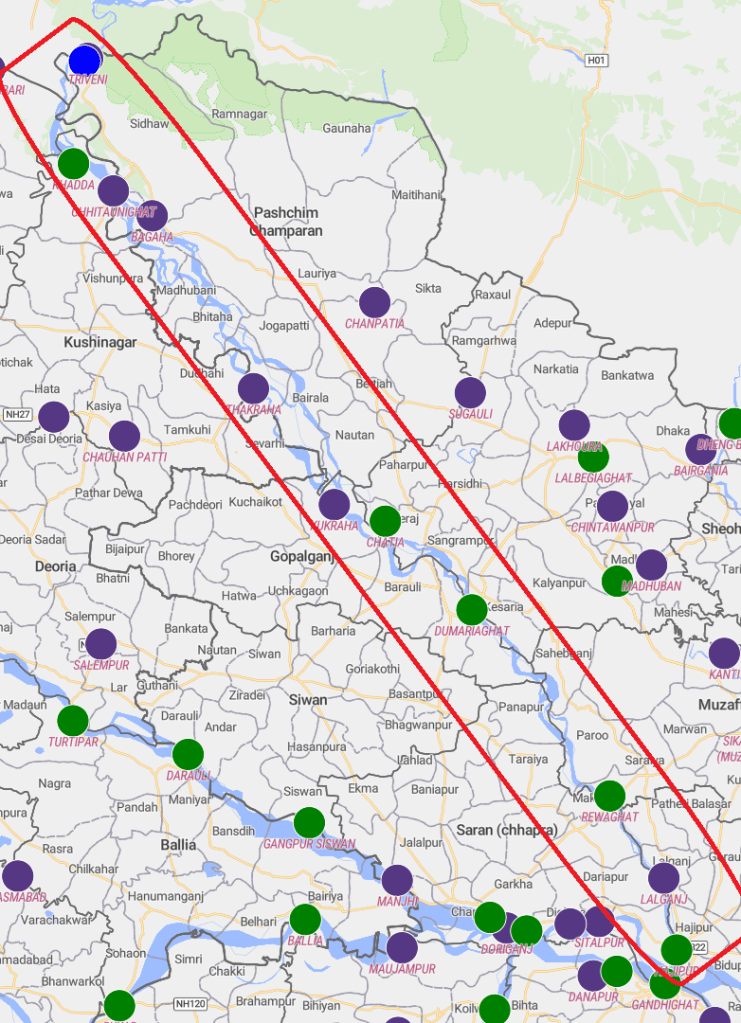
2026: Making Sense of Gandak Flood II The Gandak river faced three flood spells one each in Aug. Sept. & Oct. 2026. Two of the deluges are linked to cascading disasters in Nepal. The Sept. 2026 flood was particularly severe, recording the third-highest discharge at Gandak barrage and breaking previous HFL records at four sites. It caused widespread inundation, embankment damage and crop losses. Based on CWC data from 11 monitoring stations, this report examines the floods and raises serious questions about flood monitoring, changing river behaviour and embankment safety. Six years after SANDRP first raised these concerns, many questions have remained unanswered.
HIMALAYAN DISASTERS
Tunnels nightmare for Shimla residents, enhance precarity Cracks in the Cemetery area show what happens when we tunnel a young mountain without studying it. The fear of Chalaunthi has come back to haunt Shimla. This time it is the Cemetery area of the Shanti Vihar ward, where the same four-lane tunnelling has led to cracks in homes. Residents say that the floors and walls of at least seven buildings have developed cracks. When an administration team visited the site recently, it counted eight houses, with cracks even in retaining walls. The residents say blasting is done at night. The tunnel passes beneath 250 to 300 buildings. Tikender Singh Panwar
SOUTH ASIA
Bhutan: As of Nov 2, the temporary lake was reported to be stable, with no noticeable rise in water levels and its outflow remaining constant. Bhutanese authorities were monitoring the site, while controlled explosions were being considered to facilitate the drainage of accumulated water. However, a subsequent report by Bhutan Broadcasting Service on Nov 3 said a substantial volume of water remained in the upper lake. The possibility of another outburst had not been ruled out, although authorities were yet to verify the situation through a physical inspection. The precise trigger of the October 29 outburst also remained unconfirmed.
An almost real-time satellite-based assessment of the impact of the glacial lake outburst flood (GLOF) in Bhutan’s Gasa district on October 29 has revealed a 73% reduction in the surface area of Sintaphu Tsho, the affected Himalayan glacial lake.
Strengthen Himalayan GLOF preparedness The priority now is to establish how the event unfolded, what information was available to the authorities, and how warnings were communicated and acted upon. The central question is not simply whether potentially dangerous glacial lakes can be identified, but whether scientific assessments are translated into sustained monitoring, informed decisions and effective preparedness before the next flood occurs.
Ganga water treaty renewal in doubt The chances of the Indo-Bangladesh Ganga water Treaty getting automatically renewed next month are growing slimmer by the day, with no clarity yet on Bangladesh PM Tarique Rahman’s India visit, ET has learnt. Significant changes to the treaty terms, including a much shorter tenure, are also being considered, it is learnt. The 30-year-old treaty, signed in 1996, will lapse on December 12. India is unlikely to renew the treaty automatically without a visit by Rahman, sources indicated.
SANDRP
Also see: DRP 02 Nov 2026 & DRP 26 Oct. 2026
Follow us on: www.facebook.com/sandrp.in; https://twitter.com/Indian_Rivers


