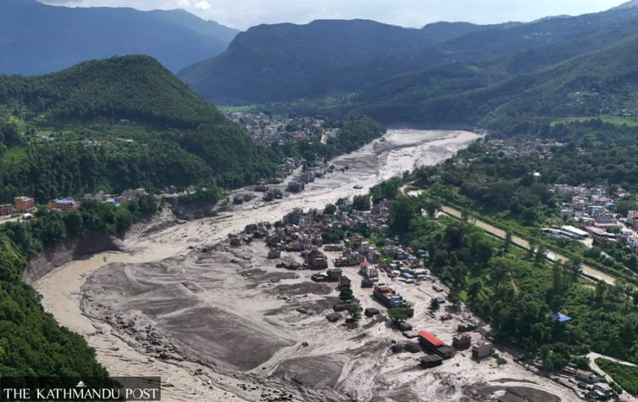
(Feature Image: Hunge Bazar in Nuwakot, damaged by the Bhotekoshi floods. Source: Angad Dhakal/TKP)
In the wake of the Aug. 26 Nepal disaster, civil society groups in India have demanded urgent measures to protect people, mountains and rivers from increasingly complex and cascading disasters across the Himalayan region. The statement issued under the umbrella of People for Himalaya rightly appeals for high-altitude and trans-Himalayan areas to be treated as no-go zones for high-risk mega infrastructure projects, including large hydropower projects.
The statement also underlines that large dams, tunnels, roads, tourism and urban expansion are already reshaping rivers, slopes and valleys across the Himalayan region. Rebuilding damaged infrastructure and new projects in the same inherently fragile, vulnerable areas can further increase exposure to future disasters and compound risks. Notably, similar demands have also been raised in past two weeks by concerned local communities and experts across the Teesta, Brahmaputra, Chenab and Sutlej basins.
The larger message of the statement is that we urgently need to move away from a project-centric development model that contributes to recurring and catastrophic disasters. The rapid, unabated expansion of projects in the Himalayas, without adequate assessment of cumulative risks, has been acting as a force multiplier for disasters. A
t present, we remain largely reactive, focusing on post-disaster response rather than preventing and reducing risks. This must be changed through risk-sensitive planning, ecosystem protection and stronger regional cooperation. The sooner we listen to Himalayan warnings and concerned voices; the lesser will be the risk and impact of disasters in future.
Make the Himalaya a ‘no-go zone’ for high-risk mega infrastructures The statement also emphasised that the safety and rights of workers, including migrant workers, employed in tunnels, hydropower projects, construction sites and other high-risk infrastructure should be protected through mandatory risk assessments, emergency preparedness, evacuation protocols, communication systems and safe working conditions.
Himalayan Floods Are a Debris Event Parineeta Dandekar here explains how Himalayan floods are dominated by debris flow rather being just a water flow. But all our dam designs, dam safety, spillway capacities, river carrying capacity and other such assessments are essentially assuming water flow. These floods are geo-morphological event rather than just a meteorological event. Are our dams even safe in that context? Are we ready for their reassessments?
SANDRP argues that the failure to grasp the true physical nature of these floods represents a systemic blind spot in South Asian engineering and environmental governance. As the youngest mountain range on Earth, the Himalayas naturally function as a massive sediment conveyor belt driven by ongoing tectonic uplift, monsoonal downpours, receding glaciers, and melting permafrost.
Highlighting what it terms regulatory complacency, SANDRP points out that authorities recently granted environmental clearances to rebuild projects like Teesta 3 on the same vulnerable footprint using original impact assessments with only modified spillways, alongside approving new projects beneath unstable glacial lakes in Himachal Pradesh and Jammu. The organization cautions that until engineering standards pivot from a purely hydrological view of water flow to a geomorphological understanding of mass debris movement, infrastructure built in high-altitude valleys will continue to exacerbate catastrophic destruction and human casualties.
Bearing witness: the making of Himalayan Disaster In this recorded webinar, Bearing Witness: The Making of Himalayan Disaster, we reflect on the recent disasters in Nepal and Tibet and examine how climate change, infrastructure development, extraction and political decisions are reshaping hazards, risks and vulnerabilities across the Himalayan region. The Himalaya is not simply a landscape of “natural disasters”. Across the region, communities are experiencing the combined impacts of a changing climate and development interventions that have transformed rivers, forests, valleys and local ecosystems.
NEHR urges CM to review hydro projects downstream of high-risk glacial lakes In a letter to the CM, NEHR chairperson Ebo Mili, while reminding the CM of an earlier representation submitted in February 2024 regarding the growing threat of GLOF in Arunachal Pradesh, said “the recent glacial lake outburst disaster in Nepal, triggered by the collapse of glacier ice, is deeply saddening and serves as a stark warning. Yet India continues to ignore the same threat on our own soil.”
Stating that Arunachal is ringed by glacial lakes, the NEHR chairperson said that the National Disaster Management Authority (NDMA) has long classified many of these lakes as high-risk under Categories A, B and C, with Category A posing an immediate threat. Several of these lakes lie barely 30-50 km from the nearest road and inhabited areas, the NEHR said. The NEHR further said that in 2024, the State Disaster Management Authority itself had conducted a survey of glacial lakes and confirmed the danger by flagging many of them as very high risk.
The district-wise figures are alarming, the NEHR said, and added that Dibang Valley district has 16 glacial lakes flagged as high risk, while Anjaw has three, Tawang six, Kurung Kumey one, and Shi-Yomi one. “Despite clear and present danger, both the state and central governments continue to aggressively push mega hydropower projects located directly downstream of these high-risk lakes,” the NEHR said.
The NEHR chairperson stated that the 3,097 mw Etalin hydroelectric project is situated only about 38 km downstream of Category A glacial lakes and the 1,200 mw Kalai-II project in Anjaw district lies just below Hawai, with Category A lakes barely 30 km away. The NEHR further said that Tato-I and Tato-II projects in Shi-Yomi district stand in close proximity to high-risk glacial lakes.
SIFFYW says Siang villagers reaffirm opposition to mega dam The Siang Indigenous Farmers’ Forum Youth Wing (SIFFYW) in Upper Siang district said that thousands of villagers opposed the proposed 11,000 MW Siang Upper Multipurpose Project (SUMP) during an “unofficial meeting” held on 27 August.
The organisation said that villagers are also deeply concerned about a glacial lake measuring approximately 8.18 hectares, classified as Category A by the National Disaster Management Authority and located about 25 km from Tuting. “The proposed 11,000 MW Siang Upper Multipurpose Project lies directly downstream of this lake. Locals describe the decision to build such a massive project in this location as reckless and deeply inconsiderate of the Adi community’s safety and future,” the organisation claimed.
It said the proposed dam site lies in seismic Zone V, a highly fragile and active earthquake zone. Villagers have expressed deep fear that constructing a massive reservoir holding billions of cubic metres of water in such a region is an invitation to catastrophe, the organisation said.
Why the Nepal disaster is a warning Arunachal Pradesh cannot ignore The Nepal disaster underscores a hard truth: infrastructure built without rigorous, cumulative risk assessment — one that accounts for climate projections, multi-hazard cascades, and ecological limits — can become a liability rather than a resilience asset. Poor maintenance, underfunded restoration, and gaps in early-warning systems only make outcomes worse.
Treating the Nepal tragedy as a wake-up call means shifting from reactive recovery to proactive risk reduction — one that prioritises ecological integrity alongside resilient, not merely expanded, infrastructure. Failing to do so only raises the probability that the next major debris flow or GLOF will strike Indian territory with comparable, or greater, human and economic cost. (Neha Desai)
Sikkim Body Urges PM to Scrap Hydro Projects The Sikkim Bhutia Lepcha Apex Committee (SIBLAC) appealed to Prime Minister Narendra Modi to freeze all new hydropower initiatives in the state and commission an independent, time-probe investigation into projects already operating there.
Tseten Taski Bhutia, SIBLAC’s convenor and also chief advisor to the Bharatiya Janata Party’s Sikkim unit underlined that the floods in Nepal suggest “a fresh assessment of development activities” is required. “The disaster in Nepal highlights the vulnerability of the Himalayan region, requiring a fresh assessment of development activities,” he said, adding that the Union government needed to rethink its plans for further hydroelectric development on Sikkim’s rivers.
Bhutia also pressed for a thorough, independent review covering the environmental, geological, seismic, social, and national security dimensions of every hydropower project in Sikkim, both existing and proposed, and asked that the government release a white paper detailing the outcomes of this assessment.
Melting glaciers in the Eastern Himalayas, large hydropower dams in Tibet, Bhutan and even locally and the growing impact of climate change has raised alarms in the ecologically sensitive Northeastern region with experts and activists calling for urgent steps to prepare for a Nepal-like disaster.
Nepal flood: Warning for J&K’s hydropower expansion Experts argue that J&K should consider a temporary pause on fresh large hydropower commitments to allow an independent cumulative reassessment of Himalayan safety. Such an assessment, they say, should go beyond the conventional project-by-project approach. A river basin is an interconnected ecological and geological system.
Experts therefore call for cumulative assessments examining what multiple dams, tunnels, access roads, blasting, slope cutting, muck disposal and transmission infrastructure together mean for a basin. Such an assessment should map glaciers and potentially dangerous glacial lakes upstream, reassess landslide and seismic vulnerability, examine extreme-flood assumptions and determine whether dam and tunnel designs remain adequate under changing climatic conditions.
Experts also stress that construction-phase risks deserve greater attention. Tunnelling, blasting, road cutting and disposal of excavated material can alter slopes and drainage patterns, potentially increasing vulnerability in already fragile terrain.
At a meeting on Sept. 01, Union Home Secretary Govind Mohan called for “continuous and proactive monitoring” of vulnerable glacial lakes and avalanche-prone areas and said warnings must be “acted upon promptly and effectively”. He also called for a shift from “response-oriented measures towards risk-informed planning, preventive mitigation and community-level preparedness.” The directions come days after a massive glacier-related disaster in Nepal damaged hydropower infrastructure and left hundreds of workers missing in the country’s Trishuli valley.
Kashmiri geoscientist Irfan Rashid is using satellite imagery of Nepal’s recent catastrophic floods to decode how massive glacier-ice collapses trigger deadly downstream events. By analysing Landsat, Planet and Sentinel data, he links this disaster to broader Himalayan risks, arguing that science-based, pre-emptive planning is vital as glacial lakes expand and climate-driven hazards intensify across Kashmir and Ladakh.
More Himalayan disasters are already being built Across the Himalayan states of India and Nepal, unregulated construction has turned river valleys and unstable slopes into death traps. The human and developmental costs of Himalayan disasters will continue to multiply unless we act. First, there is an urgent need for strictly enforced restrictions on construction in high-risk zones. Not blanket bans – those are unrealistic – but rigorous, enforceable standards backed by risk-sensitive land-use planning.
The NDMA has already emphasised that construction practices must undergo rigorous evaluation and building regulations require updating and reinforcement. That recommendation must become law, with independent oversight and penalties for violations. The other involved nations must follow.
Second, hydropower safety standards must be redesigned for catastrophic flood scenarios, not historical averages. Independent audits of all existing and planned projects are non-negotiable. Energy security depends on resilient infrastructure, not just installed capacity. The NDMA has rightly called for the environmental effects of hydro projects to be assessed cumulatively in river basins, and for standard operating procedures to be developed for disaster response at project sites.
Third, we must have a trilateral monitoring and early warning agreement between India, China and Nepal, with realtime data sharing and funding tied to compliance. ICIMOD has warned that we are trying to navigate a rapidly changing future with an incomplete map. That map must be completed, and it must be shared. (Soumya Sarkar)
The Mountains Warn, the Rivers Carry the Warning The greatest mistake now would be to treat Bhote Koshi as another natural disaster, issue condolences, announce relief, rebuild what was destroyed and wait for the next mountain to fall. The next mountain may fall in Sikkim. The next barrier lake may form somewhere else. The next flood may travel into Bangladesh. And the next cascading disaster may make Bhote Koshi look like a rehearsal.
The Himalayas have already given us the warning. The question is whether South Asia will finally understand what the river has been telling us. A disaster that begins upstream does not belong to the country where the mountain happens to collapse. The mountain has no passport. The glacier has no border. The river has no nationality. And the people downstream have no choice. So how many more warnings must the mountains send before we finally listen? (Prakash Dahal)
Why Nepal floods should worry India As permafrost degrades, glacial lake outbursts and rock-ice avalanches are expected to increase, producing faster, debris-laden floods that are harder to forecast. And more extreme events mean more landslides and sediment in rivers, raising riverbeds and reducing channel capacity on both sides of the border. They are manifestations of the same broad Himalayan hazard system. And India’s exposure is considerable. Though the role of climate change in this incident is still being debated, the science is clear: signs of climate change have shown up across the Himalaya, from shrinking glaciers to thawing permafrost.
Nepal flood is a warning that disaster planning must prepare for chains of hazards, not isolated events, say experts. Nepal, Rishiganga and Dharali are signals of a Himalayan crisis (Jay Singh Rawat) Kedarnath, Chamoli, Sikkim, Thame and Nepal have faced devastating high-altitude disasters in recent years. But their causes differ, raising a bigger question about how Himalayan risks are changing.
HYDRO POWER PROJECTS
The unseen dangers of China’s mega dam on Brahmaputra China’s Great Bend Hydropower Project on the Yarlung Tsangpo river poses a significant threat to downstream nations like India due to its construction in a geologically fragile and disaster prone region. By Himanshu Thakkar-SANDRP.
India-China water talks must look beyond hydrological data The countries should consider combined hazard monitoring as well as risk assessment, and invest more in scientific studies and research, even if these may be in contravention of the hydropower plans that both countries have for their vast water resources in vulnerable locations such as Arunachal and occupied Tibet. (Tongam Rina)
Global financial institutions ‘ignored’ warnings in Nepal’s hydropower disaster According to an extensive investigation published by the SANDRP international financiers—including the World Bank Group’s International Finance Corporation (IFC), the Asian Development Bank (ADB), the Asian Infrastructure Investment Bank (AIIB), and the Export-Import Bank of China—pushed forward major hydropower projects in disaster-prone valleys despite documented warnings, recurring historical floods, and unheeded safety recommendations.
As Dandekar and Thakkar (SANDRP), noted, a “cumulative impact assessment” of the Trishuli basin, published by the International Finance Corporation in 2020, analysed potential environmental and social impacts of hydropower across the entire the basin, but did not discuss the threats of glacial lake outburst floods and flood disasters. While it looked at the fragmentation of aquatic habitat, reduced water availability and impacts on river-based livelihoods in the basin, which has more than 36 hydropower projects, “It did not even attempt to look upstream and assess Tibetan impacts,” they wrote. “It made no cumulative disaster plan for a basin littered with hydropower projects.”
450 MW Baglihar capacity down What was announced as a one-day shutdown for desilting at the Baglihar Hydroelectric Power Project has turned into a prolonged outage, with its 450-MW Stage-I remaining non-operational for the 18th day amid heavy accumulation of silt at the gates.
The prolonged shutdown has effectively reduced generation at the 900-MW Baglihar project by half, leaving only Stage-II, with a capacity of 450 MW, in operation. Desilting and silt-flushing operations at Baglihar began on August 18. While Stage-II was restored on August 22, Stage-I has remained out of operation because of silt accumulated around its gates, according to officials familiar with the development.
The sources attributed the situation to alleged mismanagement in the handling of the desilting exercise and said an operation involving such a critical power project required much more careful planning. A senior official associated with the ongoing restoration work said the problem was now technically difficult and potentially hazardous because of the extent of the accumulated silt.
“Our gates are five metres high, but the silt is around eight metres high,” the senior official said. This means the accumulated silt has reached around three metres above the height of the gates, considerably complicating the task of clearing it.
The official said the accumulation had taken place with the passage of time during the silt-flushing process and that engineers could not attempt to clear it hastily because of the risks involved. “It is a very risky job. We have to take precautions,” the official said. He said the high water level in the Chenab was adding another layer of difficulty to the operation.
With the water level remaining high, the teams working on the project have to balance the requirement of removing the accumulated silt with the safety of personnel and equipment, making the restoration process both technically and operationally challenging. The official also clarified that the problem was not restricted to one gate, indicating that the accumulation had affected a wider portion of the flushing system. “Work is going on, but I think it will take more than 15 days,” the official said while explaining the difficulties involved in restoring the affected 450-MW capacity.
DAM SAFETY
HP: Safety gaps in 3 dams, 12 are high hazard Twelve of Himachal Pradesh’s 15 operational dams under the State Dam Safety Organization (SDSO) have been placed in Potential Hazard Category-I, while three have been classified in Category-II following the detection of deficiencies requiring continued monitoring and remedial measures. The findings are part of the Annual Report on Dam Safety–2025-26 of the State Dam Safety Organization, prepared by the Directorate of Energy under the provisions of the Dam Safety Act, 2021. The report was tabled in the Vidhan Sabha on Sep 3 2026.
The report documents annual inspections, safety reviews, evaluations and compliance with statutory requirements. While the majority of the dams were found to be functioning satisfactorily, Giri Jateon barrage and the Malana-I and Malana-II hydel projects were placed in Category-II due to deficiencies requiring sustained monitoring and timely corrective action. The deficiencies identified in these three projects include the need for structural rehabilitation, completion of spillway works, restoration of non-functional instrumentation systems and strengthening of emergency preparedness arrangements.
The report has also highlighted the need to make dam safety systems more climate-resilient in view of the increasing frequency and intensity of climate-related hazards. Himachal currently has 26 commissioned dams, besides four under construction and one under commissioning. Of these, 17 fall under the jurisdiction of the SDSO-Himachal Pradesh. Eleven of these are owned by private power producers, while six are owned and operated by government agencies.
DAMS
Polavaram: PIL in AP HC by retired IPS for review The Andhra Pradesh high court on Aug 31 adjourned the hearing of a PIL filed by retired IPS officer AB Venkateswara Rao, seeking the constitution of an independent committee of technical and structural engineering experts to examine key construction components of Polavaram project, including the diaphragm wall, ECRF dam foundation structures, design changes, and quality aspects in gap-1 and gap-2.
Rao pleaded that the authorities concerned be directed to submit all records pertaining to quality tests conducted on the diaphragm wall, daily concrete pouring details, and slurry test records to the court. He also sought a direction restraining authorities from undertaking any further construction activity in gap-2 ECRF dam foundation zone until the expert committee submits its report. He urged the court to order independent field-level investigations, including core drilling and non-destructive testing. The court adjourned the matter.
TN farmers announce 5-day statewide stir against Mekedatu dam project Tamil Nadu farmers will launch a five-day statewide agitation from September 20 against Karnataka’s proposed Mekedatu dam across the Cauvery, the Coordination Committee of All Farmers’ Associations of Tamil Nadu announced on Sept. 04. Its president, P R Pandian, announced the protest after a five-hour meeting between a delegation of farmers and Union Minister for Power Manohar Lal Khattar in Gurugram.
Pandian said the DPR had been submitted without the required consent of Tamil Nadu, Puducherry and the Cauvery Water Management Authority (CWMA). He urged the Centre not to grant environmental or forest clearances for the project, arguing that the proposed dam would adversely affect farmers in both Karnataka and Tamil Nadu.
According to Pandian, farmers in Karnataka have also acknowledged that the project would not benefit them because the proposed dam site is located deep inside a forested area downstream of the Krishnarajasagara (KRS) dam. As an alternative, Pandian suggested constructing a dam at Rasimanal in Tamil Nadu. He claimed that farmers from Tamil Nadu and Karnataka had reached a consensus on the site during a joint meeting in 2024 and urged the Centre to allow the project.
Gangavali River faces growing water stress Water pumped from a station near Honnalli in Ankola is supplied to Ankola town, Karwar city, the Kadamba Naval Base, Grasim Industries at Binaga and 13 gram panchayats. The daily requirement is 21 million litres. “Supplying drinking water from the Gangavali until February is not very difficult. After that, storing water by constructing a sandbag barrage becomes challenging for three months. In recent years, during peak summer, the water level has fallen so low that supply had to be stopped,” said an official of City Water Supply Board.
The second-phase expansion of the Kadamba Naval Base is almost complete. It currently receives eight million litres per day (MLD), but this could rise to 21 MLD within months. If an airport comes up at Alageri, supply will have to increase further. Within a few years, more than 45 MLD may have to be supplied from the Gangavali, the official added. Construction of a weir to store summer water in the Gangavali is 36% complete, said City Water Supply Board Executive Engineer Shivarama Naik.
“We aim to complete it by June next year. Stored water will be supplied to Karwar and Ankola, while the naval base will receive water through a separate pipeline,” he added. Water levels in the Gangavali remain high only during the four monsoon months and are very low for the remaining eight months. The flow will decline even before summer. If the river diversion project is implemented, it could harm the environment and leave people in Karwar, Ankola and Gokarna without adequate water, said Save Gangavali-Karavali Awareness Campaign president Ananth Hegde Ashisara.
If water from Gangavali River, the lifeline of the coastal region, is diverted to Haveri district, the reduced flow will destroy the environment and agricultural activities in riverside villages of the Ankola area. People in Karwar, Gokarna and Ankola will struggle for drinking water. Seawater will intrude deep into inland areas, causing the destruction of aquatic life and adversely affecting fishing. Hence, the voice of coastal people against river-linking projects must grow louder, he added.
India builds first rock dam in Ladakh India has built its first rock check dam across the river at Upshi in Leh. Made entirely of natural boulders and without using cement, the dam has raised the water level by nearly 10 feet, allowing farmers to irrigate fields that had long struggled for water during the spring sowing season. The new dam stores nearly 40 million litres of water and feeds dry village fields through the Igoo Phey irrigation canal.
The Ladakh administration is now working on more such check dams on the Indus River, with work underway at some locations and many more projects in the pipeline. The Ladakh Administration has submitted a proposal to the Union Ministry of Jal Shakti for the construction of 36 check dam projects in the Union Territory, in a move aimed at strengthening water security and expanding irrigation potential. The proposal includes seven Himalayan Rock Check Dams in the Leh region and 29 Check Dams or weirs in the Kargil region, at an estimated cost of over Rs 56 crore.
INTERSTATE WATER DISPUTES
Telangana’s Tumidihatti plans Telangana plans to convey the water by gravity through a combination of two canals and a tunnel linking them from Tummidihatti to the Sundilla barrage — one of the three Kaleshwaram Lift Irrigation Scheme barrages on the Godavari.
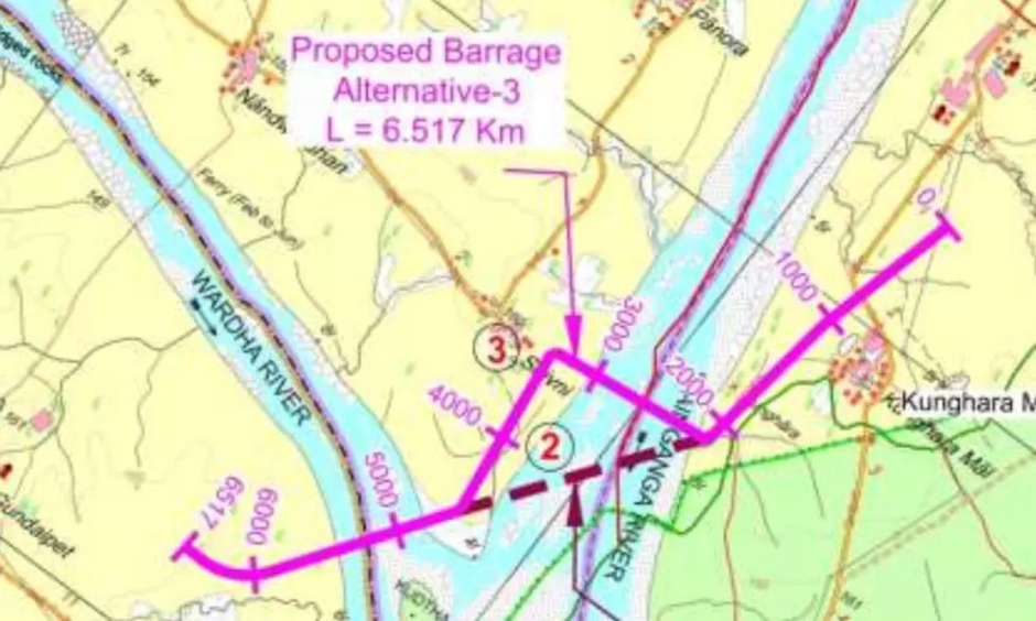
At Sept 1 meeting with Maharashtra in New Delhi, with the Central Water Commission acting as the facilitator, Telangana said that if Maharashtra agreed to a level of 152 metres, it could nearly double its annual drawal from 43 tmcft to 80 tmcft without affecting Maharashtra’s water rights. The submerged area would rise to 3,875 acres at 152 metres (from 1506 acres at 148 m). 2,156 acres of this area would be on the riverbed, while 545 acres would be land associated with the sanctuary.
Telangana’s plans include a two-pronged barrage, with one leg across the Wardha and another across the Wainganga, and both sections connected. The plan is to convey water from the barrage to Sundilla through a nearly 77-km gravity canal that will connect to a 20.9-km-long tunnel and then join another 8.25-km gravity canal. The entire project is expected to cost around Rs 12,300 crore.
Karnataka files appeal before CWMA seeking reduction in water release Ahead of the Cauvery Water Regulation Committee (CWRC) meeting scheduled on Sept. 08, Karnataka has filed an appeal before the Cauvery Water Management Authority (CWMA) seeking a reduction in water release to Tamil Nadu from 9,000 cusecs a day, as ordered by it, to 2,000 cusecs. It may be noted that the CWMA had upheld the CWRC’s August 25 direction to Karnataka, asking it to ensure flows of 9,000 cusecs a day for 15 days from August 25 to be realised at the Biligundlu water gauge on the inter-State border. According to the CWMA’s order, the releases by Karnataka would total up to 11.66 tmcft.
Bihar, Jharkhand settle 25-year Sone water row Bihar and Jharkhand Aug. 31 signed a water-sharing agreement for Sone river, resolving a 25-year-old dispute over sharing of water between the two states. Though an agreement was reached among Uttar Pradesh, Madhya Pradesh and undivided Bihar on the water sharing of Sone river and the cost of Bansagar dam in Madhya Pradesh in 1973, a dispute started in 2000 when Jharkhand was carved out of Bihar as a new state and it demanded a bigger share of water in Bansagar project as a large chunk of the catchment area came under it. Bihar, on the other hand, cited the 1973 agreement to claim water from the project.
IRRIGATION
HC halts land acquisition for Malwa canal until EIA The Punjab and Haryana high court has halted further land acquisition proceedings for the proposed 149-km Malwa canal until the environmental impact assessment (EIA) is finalised. The court heard the matter on Aug 25, with the order uploaded on Sept. 01. The petitions raised concerns over the proposed canal drawing water from Harike Barrage in Ferozepur, which receives water from Satluj and Beas rivers. The petitioners said polluted water from Ludhiana’s Buddha Nullah reached Satluj before entering the barrage.
During the Aug 17 hearing, their counsels said villagers and panchayats had opposed the project, citing the absence of a proper EIA and lack of clarity from the water resources department on the source of water to be carried through the canal. They alleged that water in Harike Barrage was highly polluted and toxic, and said using it for irrigation could affect people, animals and crops in the area.
Punjab govt had announced the canal project on Jul 27, 2024. The 149-km canal is proposed to have a carrying capacity of 2,000 cusecs and is estimated to cost Rs 2,300 crore. The govt said it would benefit 2 lakh acres of farmland in Faridkot, Ferozepur and Muktsar.
URBAN RIVERS
Unravelling Pune RFD: The Five Questions This blog presents thought provoking presentation about the Pune River Front Development Project. The amazing presentation is by well known expert Sarang Yadwadkar, who has file numerous cases in NGT and HC regarding Pune Rivers related issues. He is also an Architect & Member of the Planning Committee of the Development Plan of Pune City. Explanatory text is by Tara Tanmayi of SANDRP.
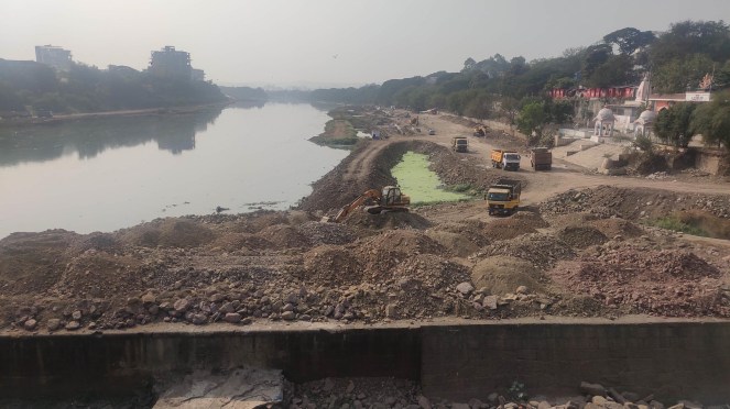
The most important question raised by SANDRP goes to the heart of the project’s flood-risk calculations: “Whether Flood Values considered are correct? Water Resources Department has certain guidelines for demarcation of flood lines.” This concern is backed by independent technical analysis. A comparative chart of flood-discharge values used in the RFD project versus those of the state Water Resources Department (WRD) reveals stark discrepancies. For the Mula-Mutha confluence, the RFD project uses a 100-year flood figure of 4,760.89 cubic metres per second (cumec), while the WRD’s figure is 12,868.80 cumec — a gap of more than 170%.
Siddapur villagers are protesting waste facility Siddapur is an important rainwater recharge zone, according to Amme Raghavender of the Save Siddapur movement. Surface runoff from the proposed site flows through several drainage routes towards nearby water bodies. Three routes eventually drain towards Himayat Sagar lake in Ranga Reddy district, while another drains towards the Dindi River. One route passes through Palmakul Cheruvu, the largest storage tank upstream in the Esi River system, before eventually reaching the Himayat Sagar reservoir, an important source of drinking water for Hyderabad.
The Esi River eventually joins the Musi River, connecting the drainage system around Siddapur to the wider Musi basin. Residents and environmental activists fear that waste or leachate from the proposed facility could contaminate surface or groundwater and affect the water bodies used to irrigate agricultural land in the area. The concerns also extend to the government’s Musi River Rejuvenation Project, which aims to restore and clean a 55-km stretch of the river from Gandipet to Gowrelli. Residents fear that contamination of water bodies connected to the Musi system could undermine these efforts.
RIVERS
Andhra Deputy CM directs APPCB to study water pollution in Godavari A State-level task force headed by the Principal Secretary to Environment and Forest and APPCB Member Secretary was constituted in May to address the pollution of the Godavari. The Collectors of the districts of East Godavari, Kakinada, Dr. B.R. Ambedkar Konaseema and West Godavari are members of the task force. The ₹100-crore fund released in May will be utilised for a comprehensive study of pollution in the Godavari River, says Deputy Chief Minister K. Pawan Kalyan.
Environmental norms violation in Belagavi village NGT took up the matter of an ethanol plant violating environmental norms in Ugar Khurd village in Belagavi district, Karnataka on August 29, 2026. NGT’s principal bench directed the matter to be listed before the southern bench on September 23, 2026. The applicant was directed to produce available material on the matter at the next hearing date.
The application stated that the ethanol factory has caused severe air pollution, water pollution, soil pollution, and noise pollution in the surrounding area; consequently, local people are facing serious health problems and environmental disturbance. The water near wells and borewells has become polluted and unfit for drinking. Agricultural lands and crops in the area are also being a adversely affected, leading to poor crop growth and reduced productivity. Untreated waste water from the factory is being released into the Krishna river, causing water contamination and environmental damage.
Jojari’s Lament Once the lifeline of the region—hundreds of villages and hamlets on its banks depended on it for their basic water needs—the 83-km-long seasonal rivulet now smells worse than a Delhi nullah, laid waste and poisonous by over two decades of incessant dumping of toxins and effluent from textile mills, steel factories and tile factories in Jodhpur, Pali, and Balotra.
The river has become a source of misery for thousands of people, particularly poor farmers living along its course. The accumulation of sludge over the last two decades has caused the embankments of the river to break, allowing polluted water to enter the farmlands, rendering the agricultural land barren, while severely affecting the wildlife and vegetation in the area.
Shravan Patel, a local climate activist questioned the political will of successive governments to address the crisis. Before the 2024 elections, a riverfront project for Jojari was announced and Rs172 crore was sanctioned. Yet, Shravan said, not even a single brick has been laid.
1,900 MT waste cleared in Poonch after NGT action In a major development the Municipal Council Poonch has finally removed around 1900 Metric Tons-MTs of legacy waste dumped near Poonch river for the last 20 years. The action, as per a statement issued, was taken by district administration and MC Poonch after environmental activist and chairman J&K Climate Action Group -JKCAG Dr Raja Muzaffar Bhat filed a case in the NGT three years back.
This was followed by the imposition of a huge penalty of Rs 2.71 crores under the Polluter Pays Principle (PPP) last year. The municipal council had deposited Rs 25 lakhs in the account of the Deputy Commissioner Poonch and for recovery of the rest of the money the NGT had directed the auctioning of assets. It is believed that the Rs 25 lakh penalty amount would be used for restoration of the site and to set up an eco-park near the erstwhile garbage dumping site.
Scientist Quits Lucknow Ganga Committee A senior scientist, Prof Venkatesh Dutta, has quit from the District Ganga Committee (DGC), Lucknow, saying he was excluded from crucial decisions related to the protection and rejuvenation of its surroundings and that he could not back “mindless” construction of embankments and highways in eco-sensitive zones.
He said in his resigation letter, sent to DGC chairman Vishak G., the Lucknow district magistrate, and member secretary of the DGC Sitanshu Pandey, that he had opposed the proposed expansion of a “green corridor project” on the Gomti River’s floodplain, but this proposal was pushed through by the rest of the committee without his knowledge.
DPCC finds waste dumping near Yamuna Delhi Pollution Control Committee (DPCC) has found substantial quantities of refuse-derived fuel (RDF), inert material, and construction and demolition (C&D) waste dumped at multiple locations along the boundary wall of NTPC Eco Park, around 2km from the Yamuna, in southeast Delhi’s Badarpur. Officials were informed that the agencies concerned had an agreement with NTPC Ltd for filling low-lying areas within the park with processed inert and C&D waste, but DPCC, while inspecting the site, flagged several deficiencies in the handling and transportation of the waste.
The inspection was conducted on July 14 on the directions of NGT, which took suo motu cognisance of a TOI report, ‘Okhla landfill waste dumped near Yamuna’. In a report dated Sept 2, which has been submitted to NGT, DPCC said the trucks transporting processed inert material and C&D waste from Okhla and Ghazipur landfills were found without green nets or tarpaulin covers, resulting in considerable dispersion of dust. “Such practice is not in conformity with prescribed dust mitigation measures,” it pointed out.
Green nod to Akshardham expansion The State Environment Impact Assessment Authority (SEIAA) has recommended environmental clearance for the expansion proposed by the Bochasanwasi Akshar Purushottam Swaminarayan Sanstha (BAPS). However, the recommendation comes with several environmental conditions. Under the proposal, 2,954.2 sq m of the existing assembly hall will be demolished and replaced with new construction covering up to 24,500 sq m in and around the existing structure. This would increase the complex’s built-up area by about 21,545.7 sq m, taking the total built-up area to approximately 90,807.5 sq m.
Environmental experts have raised concerns over the expansion. Yamuna activist Bhim Singh Rawat said the key question is whether the proposed site falls within the Yamuna floodplain or the ‘O’ Zone. He pointed out that the groundwater table in the area is only about 4.05 metres below ground level and that the expansion would add another 21,545.7 sq m of concretised area.
DJB to start 18-20 new STPs A key part of the Delhi Jal Board’s (DJB) ambitious plan to nearly double the amount of sewage it can treat in a day is to start 18-20 new STPs with a total capacity of treating 460 MGD, an official told The Hindu. Doubling of the sewage treatment capacity is an important element of the government’s plan to clean the Delhi stretch of river Yamuna. In July last year, Union Home Minister Amit Shah chaired a meeting on the river’s rejuvenation and directed the Delhi government to nearly double its sewage treatment capacity to 1,500 MGD by 2028.
DJB blames DUSIB for delay in STPs The DJB is taking all necessary and expeditious steps to ensure complete interception, diversion and treatment of sewage from all identified drains, subject to the grant of requisite permissions by the concerned authorities. This was stated in the report filed by the DJB on August 29, 2026 before the NGT. The report stated that DJB had already submitted to the tribunal that out of the 22 drains identified for trapping by DJB, the works for five drains (Pant Nagar / Lajpat Nagar) have been completed. In respect of KD1 (Hill view SPS, Vasant Vihar), the modular decentralised sewage treatment plant (DSTP) work is in progress and likely to be completed by December 31, 2026.
63 MLD sewage bypasses STPs in Gurugram In March 2024, 63 MLD of sewage was not reaching the city’s existing STPs, with the audit noting that it was apparently being released untreated into drains. Treatment capacity cannot be used if the sewer network does not collect and carry wastewater to the plants.
The city was generating 550 MLD of domestic sewage in areas under GMDA. Of this, 90 MLD was being treated and reused by colonisers within their premises, leaving 460 MLD to be treated through govt system. GMDA had an installed capacity of 415 MLD across 12 STPs, against the 460 MLD requiring treatment. Yet the average sewage reaching the plants was only 397 MLD, leaving 63 MLD outside the treatment system. CAG said this represented 14% of the sewage requiring treatment.
GMDA told CAG that it had prepared an action plan after a detailed survey of drains involving MCG, HSVP, HSIIDC, PHED and HSPCB. It said measures had been taken to increase treatment capacity to 977 MLD by Dec 2028, enough for projected sewage generation of 800 MLD as well as sewage diverted from drains. The existing gap, however, raises a question over how effectively that additional capacity can be used if sewer connectivity does not expand alongside it.
The problem is particularly evident at Jahajgarh, where GMDA approved a 20 MLD STP in March 2020. Only 5 MLD of sewage was reaching the plant because the required sewer infrastructure was incomplete. CAG said Rs 18.67 crore spent on the project remained largely idle, while the objective of treating 20 MLD remained unachieved. The audit attributed the problem to lack of coordination between GMDA and MCG. MCG manages internal sewer lines and household sewer connections, while GMDA manages master sewer lines and STPs. The Jahajgarh case therefore illustrates how gaps between the two parts of the network can leave treatment capacity unused.
At Manesar, the problem was the delayed creation of treatment capacity. GMDA approved a 25 MLD STP for Manesar and Naharpur-Kasan in March 2020. After three unsuccessful tender attempts, the work was awarded in Jan 2022 for Rs 35.7 crore, with completion scheduled for Oct 2023. CAG found that delays in tendering and construction resulted in prolonged discharge of untreated wastewater from Manesar and Naharpur-Kasan into drains and open land.
The environmental consequences are already visible. CAG found that only 12 of the city’s 16 STPs were meeting prescribed wastewater discharge norms. The audit also found problems in MCG’s decentralised sewage treatment program. Of 21 micro STPs planned under one package, only nine had been completed when auditors inspected them in Dec 2024. One had a stolen motor, three were partially functional and 12 remained incomplete after five years. CAG said Rs 11.9 crore spent on the incomplete plants remained largely idle.
HSPCB runs with 41 officials on deputation, 27 posts vacant HSPCB is functioning with 27 sanctioned posts lying vacant and 41 officials on deputation, while seven officers have been assigned additional charge alongside their regular responsibilities. The figures are part of an RTI response issued by HSPCB on Sept 2 and assume significance in light of a NGT direction issued in April 2023 on strengthening pollution control boards.
The tribunal had said key regulatory positions, including regional officers, engineers and scientists, should be full-time and incumbents should not be given any additional charge. Despite the direction, HSPCB said it had not sent any requisition to Haryana Public Service Commission (HPSC) or Haryana Staff Selection Commission (HSSC) to fill the vacant posts. It also said no requisition had been sent to the concerned departments or the govt to increase the number of sanctioned posts.
RIVERS BIODIVERSITY
Kaziranga’s Panbari wildlife corridor missing from govt documents The gazette notification “No. FRW.7/2022/Pt.V/01 – 9 (nine) animal corridors connecting Karbi Anglong Hills and Kaziranga National Park”, dated April 1, 2022, does not have any information on the Panbari corridor even as it specifically mentions nine corridors in the introductory note before giving details of the other eight corridors. Surprisingly, the notification also does not mention under which rule it had been issued.
Whether the omission of the corridor is inadvertent or deliberate, the development has triggered speculations whether it had something to do with the recent discovery of rare earth element (RRE) deposits in the Panbari-Geleki area of Karbi Anglong – very close to Kaziranga National Park.
Turtles flee poisoned waters of Kajalheri For years, the pond at Kajalheri village in Haryana’s Fatehabad was a safe haven for hundreds of rare turtles. Today, the same waters are forcing them to flee for their lives. The Shri Guru Gorakhnath Community Reserve, notified by the Haryana Government in 2019, is home to an estimated 150–200 Indian Softshell, Red-roofed and Indian Peacock turtles. But the sanctuary, where the reptiles once came to breed and lay eggs, has allegedly turned into a toxic habitat because of untreated sewage and neglect by the authorities.
FISH, FISHERIES, FISHERFOLKS
Durgam Cheruvu fish death blamed on sewage flow The HMWS&SB on Sept. 05 identified four major sewage inlets that was carrying sewerage into the Durgam Cheruvu at Jubilee Hills, resulting in the death of, according to fishermen, tonnes of fish. Officials identified four major routes through which sewage is entering the lake — the Madhapur I&D nala, Silent Valley I&D nala, Vitthal Rao Nagar box nala and the route from the TGIIC layout. They inspected the flow at the inlets and discussed measures to stop sewage from reaching the lake.
Officials said the existing STP at Durgam Cheruvu is functioning at full capacity. However, the rapid growth of residential areas and population around the lake has resulted in a significant increase in sewage generation. During the monsoon, the problem is compounded by additional flows entering along with rainwater. The team that inspected the lake decided to study the topography and hydrology of the surrounding areas and prepare a permanent action plan to prevent sewage from mixing with the lake water. The plan will include sewage diversion, treatment and other technical measures at the four identified inlets. Officials will work in coordination to implement the measures.
SAND MINING
Telangana: Kawal Tiger Reserve Affected by Illegal Sand Mining Illegal sand mining from streams and rivulets is reducing recharge and water storage capacity, thereby affecting wildlife and forest conservation in the Kawal Tiger Reserve of erstwhile Adilabad district. Forest officials say wild animals are increasingly coming out of Kawal Tiger Reserve and entering surrounding villages in search of drinking water. In the process, the animals are damaging standing crops and also attacking humans.
Officials say villagers must understand the importance of sand for water recharge in streams and rivulets, which helps conserve the ecological system. The illegal mining is leading to clashes between villagers and forest staff, when the latter obstruct illegal sand mining. The clashes are ending up acquiring a political colour. Nirmal district forest officer (DFO) Susant Sukhadev Bobade said they are trying to control illegal sand mining from streams and rivulets in the Kawal Tiger Reserve. This is resulting in decline in water storage capacity, causing shortage of drinking water for the wildlife.
The DFO said they have never stopped villagers from lifting the sand from Godavari River, which is just 25 km from the villages located in Kawal Tiger Reserve. “The sand found in streams and rivulets is very soft and high quality without a mixture of soil. There is a good demand for such sand, unlike sand excavated from the river Godavari,” observed Susant Sukhadev. This summer, most of the streams and rivulets have dried up due to a prolonged dry spell and scanty rainfall. Forest officials are thus focusing on rainwater percolation tanks to improve groundwater table to provide drinking water for wildlife.
There are allegations that supporters of political leaders are the ones involved in illegal sand mining from the streams and rivulets in Kawal Tiger Reserve. They are making a quick buck since there is a huge demand for the sand in the market. However, this is at the expense of wildlife being deprived of drinking water in the long run. Further, those lifting the sand are mostly non-tribal, who have a strong political and economic hold. They dominate the tribal people and even exploit them, for example in the villages located along Jannaram to Utnoor in Kawal Tiger Reserve. Almost all the Adivasi families living inside the forest in these areas are in a pathetic condition, without much development in their hamlets.
J&K mining sector set for digital overhaul, 20 more reforms in pipeline Among the measures already introduced are the Integrated Mining Surveillance System (IMSS), satellite-based monitoring and geo-fencing, marking a shift towards technology-driven supervision of mining operations. The government is also proposing a new Minor Mineral Policy aimed at addressing distortions and anomalies in the existing regulatory framework.
Bridge over Lohit river collapses A vital bridge over the Lohit river in Anjaw district has collapsed, cutting off connectivity to several remote villages, including Kaho near the India-China border, officials said on Sept. 01. Women and Child Development Minister Dasanglu Pul, who represents the Hayuliang Assembly constituency attributed the damage to repeated movement of overloaded vehicles despite the load-bearing capacity being clearly indicated on the bridge.
WETLANDS, LAKES, WATER BODIES
How droughts and glacial melt reshape India’s water reservoirs India has a vast number of Surface Water Bodies (SWB) distributed across different climatic zones. They are categorised into small (0.1–1 km2), medium (1–10 km2), and large (>10 km2) and are becoming increasingly vulnerable to climate extremes, particularly droughts, disrupting the balance between inflows and outflows. However, very little information is available on the impact of droughts on SWBs in India.

This open access study titled ‘Drought-driven shrinkage of surface water bodies in India’ by M Niranjannaik and Vimal Mishra, published in iScience aims at exploring the impacts of droughts and their severity on shrinkage patterns of SWBs across different climatic zones in India. The study examines Lansat satellite-derived area data on 10,476 SWBs during 1990–2017 to understand their shrinkage patterns.
RAMSAR WETLANDS
Panel to finalise full tank level of Kerwa, Kaliasot, Bhoj wetlands The NGT central bench directed the constitution of a seven-member committee on August 31, 2026, to finalise the full tank level (FTL) of Kerwa, Kaliasot and Bhoj Wetland (Bada Talab and Chota Talab) in Bhopal, Madhya Pradesh.
The committee should also ensure geo-tagging, satellite imagery, ground truthing, remote sensing and drone survey application with videography at the places where the FTL water level has exceeded the fixed point of pillars already installed during the summer season. In addition to above, the court directed the inclusion of four environmental specialists to participate in the proceedings or working of the committee formed. The court will next hear the case on September 15, 2026.
WATER OPTIONS
India’s Problem Is How We Have Governed and Managed Water Assets Himanshu Thakkar, coordinator of SANDRP, discusses India’s water crisis, why its impact hasn’t been dramatic yet, and why the situation could worsen if we don’t change course.
Managing Darjeeling’s springs in a changing Eastern Himalaya Drawing on a decade of fieldwork informed by environmental history and political ecology, we argue that this supply-demand framing obscures more than it reveals, and that the tension between commons and enclosure offers a more productive analytical lens. Through this lens, the samaj-managed springs emerge as the most socially and ecologically embedded of the three systems, constituting what we term a cosmopolitical commons, in which human obligation, ecological process, and embodied knowledge are not merely linked but mutually constitutive. The samaj-managed springs are, however, also a contested commons: the other two systems, driven by statist and commodifying logics of enclosure and extraction, are eroding the samaj’s capacity for collective stewardship even as the springs themselves deteriorate under intensifying urbanization and climatic stress. Addressing Darjeeling’s water crisis thus requires more than supply-side investment: it demands recognizing commoning as the city’s most resilient water management system, supporting it institutionally, and actively resisting the enclosures that undermine it.
Damage to Bidar’s karez water system Fresh concerns have surfaced over alleged damage to the centuries-old Naubad–Aliyabad karez (qanat) water system in Bidar, following unauthorised digging and alteration near its outlet, raising alarm among conservationists and prompting intervention by the district administration.
Deputy Commissioner Shilpa Sharma visited the site after receiving complaints about the damage and directed officials to immediately halt any unauthorised activity, initiate action against those responsible, and ensure that conservation measures are undertaken in consultation with experts familiar with the karez system, sources in the district administration said.
The Naubad–Aliyabad karez, believed to have been built in the 15th century by the Bahmani Sultanate, is an ancient underground water-harvesting system. Conservationists point out that the system holds strong potential for nomination as a UNESCO World Heritage site if conserved scientifically.
Communities ‘marrying glaciers’ to bring new water to life In the Pakistan-administered Gilgit-Baltistan – an autonomous territory in the wider disputed Kashmir region – communities are turning to the Indigenous practice of glacier grafting, known locally as Gang Khswa, to combat water scarcity and adapt in the face of climate change.
Glacier grafting is a traditional method in which local communities create new, artificial glaciers in high-altitude regions to create a reliable source of water for irrigation, livestock and daily life. The technique is often referred to as a glacier marriage, when ice is collected from so-called male and female glaciers and transported to a new grafting site, chosen by the community, to create a new glacier.
Once the new glacier is exposed to several snow cycles, it will slowly start to expand. If successful, the glacier will start to root and produce water after about ten years. After roughly another decade, the glacier will have grown into a reliable water source. Dr. Zakir highlighted two other techniques derived from glacier grafting: ice towering and avalanche harvesting.
Ice towers, also called ice stupas as their conical shape resembles a Buddhist sanctuary, act as ice reservoirs designed to melt slower as its surface area is not fully exposed to the sun. Developed in Ladakh, the technique involves passing glacier meltwater through underground pipes and spraying it into the freezing air.
Avalanche harvesting, a recent innovation, involves the installation of a mesh net in a narrow gorge to capture and store snow and ice from avalanches. Although glacier grafting was only revived in the 1990s, the ecological practice goes back centuries and is deeply rooted in local tradition, knowledge and ancestry. The history of glacier grafting is believed to date back to the 14th century.
From start to finish, the community plays a key role in the practice. No glacier can be seeded without the community’s consent first, and once the grafting is complete, locals take on the responsibility of caring for the ‘baby’ glacier. They monitor its progress, report on its development and add snow when necessary to help it grow.
GROUNDWATER
Gujarat villagers blame factories for water pollution A protest over alleged chemical contamination of drinking water has entered its 12th day in five villages of Dholka in Gujarat’s Ahmedabad district, with residents claiming that 54 people have died of cancer over the past seven years. Villagers from Bhetavada, Trasad, Nesda, Paldi and Ambareli have accused factories operating near their homes of releasing chemical-laden water into drains, which they say eventually contaminates groundwater and village borewells.
Residents claim that contaminated water frequently appears in the school’s borewell, adding to parents’ fears about sending their children to school. The protesters say people of all age groups are being affected, with even young children suffering from skin problems. The issue has also heightened fears around groundwater, with many residents now reluctant to drink water from their village borewells.
The protest has brought forward several families who say they have lost loved ones to cancer or are still struggling with the disease. Thirty-two-year-old Harshad Makwana, a resident of Bhetavada, is battling oesophageal cancer. He underwent treatment at a private hospital in Ahmedabad three months ago, at a cost of around Rs 10 lakh, and continues to undergo routine check-ups. Harshad had already lost his elder brother and mother to cancer. He said around Rs 15 lakh was spent on his brother’s treatment shortly before his death.
Nareshbhai told India Today that his 51-year-old father, Bhagwan Makwana, developed oral cancer six months ago. Two months later, Nareshbhai’s mother, Vilas Makwana, was diagnosed with a cancerous tumour in her stomach. The family said it arranged the money for both treatments by selling jewellery and mortgaging farmland. Nareshbhai’s grandfather had also suffered from laryngeal cancer and died of the disease eight years ago.
With villagers increasingly afraid to use borewell water, an RO plant has been installed at the village borewell, allowing residents to collect drinking water. However, locals Chirag Pandav and Ajay Makwana told India Today that the RO plant belongs to the private company against which they are protesting. They alleged that residents have to pay Rs 5 for hot water and Rs 10 for cold water. The system operates through a rechargeable card, and water is not dispensed if the card does not have sufficient funds. The protesters have therefore questioned why villagers have to pay for drinking water while simultaneously holding the company responsible for the alleged contamination.
The villagers said the protest would continue until September 8. One of the protesters said that if their concerns are not addressed, they plan to travel to Gandhinagar and lay siege to the Gujarat Legislative Assembly during its session. The protest has brought together a large number of residents, including women from all five villages, who say their demand is for action over the alleged contamination of their water sources and the health problems they believe are linked to it.
URBAN LAKES, WETLANDS
Construction debris piles up as Basai plant capacity nod lapses in Haryana The approval allowing processing of 1,200 tonnes of construction and demolition (C&D) waste per day at the Basai facility expired on Aug. 31, triggering uncertainty over how the city will manage the massive quantities of debris generated every day. MCG commissioner told TOI that the private operator would be asked to continue processing C&D waste at the enhanced capacity of 1,200 tonnes per day (TPD). However, representatives of the firm have taken a contrary position, making it clear that they will not operate at the enhanced capacity without a formal written approval from state govt. According to the firm, it will continue to collect and process only 300 TPD until state govt formally approves the increased capacity of 1,200 TPD. The dispute assumes significance because the city generates more than 1,500 tonnes of C&D waste every day.
URBAN WATER
Bengaluru Water Security Depends on Fixing the Whole System Bengaluru’s water strategy is consequently being tested on several fronts at once. Cauvery Stage VI and other augmentation projects address supply. Rainwater harvesting and aerators address conservation. Wastewater reuse addresses demand substitution. Leak detection, metering and action against illegal connections address efficiency and revenue. Road-restoration agreements and a common work portal address the institutional coordination needed to build and maintain the network.
The evidence supplied by BWSSB confirms the direction of policy, but not yet its outcomes. The city has project approvals, planned programmes and administrative measures. It does not yet have, in the supplied material, a published timeline for every intervention, quantified targets for reuse or leakage reduction, or a clear account of how much each measure will contribute to future demand.
That distinction will matter as Bengaluru moves beyond emergency responses to recurring water stress. The city’s water security will depend not only on bringing in more water, but on whether institutions can reduce losses, build confidence in reuse, maintain decentralised conservation systems and coordinate construction across the urban network. The next milestones to watch are the implementation of Cauvery Stage VI, the design of industrial treated-water arrangements, expansion of rainwater harvesting and the publication of measurable progress on unaccounted-for water.
The Bangalore Water Supply and Sewerage Board (BWSSB) has launched a massive plan to fit water-saving aerators on nearly 9.3 lakh taps across the city, hoping to reduce water consumption by up to 25%. BWSSB has earmarked `4.87 crore. BWSSB supplies more than 11.3 lakh water connections, and the plan targets the nearly 9.3 lakh taps that have not already received an aerator. The devices fit onto tap mouths, mix air into the stream and cut water volume without weakening flow or inconveniencing users.
A BWSSB official said, “The result could be significant across a city where millions of litres of treated drinking water are used every day. A conventional tap without an aerator can typically discharge around 10 to 15 litres a minute. A 3-litre-per-minute, or 3 LPM, aerator can bring that down to a maximum of three litres a minute. In other words, the tap continues to provide a steady, foamy stream, but considerably less water flows through it.” BWSSB first installed aerators in government offices and public places during the 2024 summer shortage. It has reportedly installed more than one lakh devices in two years.
The second phase covers government offices, industries, apartments, commercial buildings and homes. The latest phase began on July 1, and the board fitted 46,504 aerators by August 10. Officials plan rapid expansion in the coming months amid rainfall and water-reserve concerns. BWSSB officials said they would add the cost to customers’ water bills. Board chairperson Dr N Manjula said the initiative aims to reduce wastage and encourage residents to use drinking water responsibly. She urged citizens to combine aerator use with economical water-use habits.
The Bangalore Development Authority (BDA) has completed 1,441 RWH percolation wells across 77 BDA parks and residential premises, with the infrastructure estimated to recharge 184.59 million litres (18.459 crore litres) of rainwater annually.
Hyderabad’s groundwater table sinks five metres in a year The latest assessment by the ground water department puts the average groundwater depth in Hyderabad at 11.20 metres below ground level (mbgl) in Aug 2026, compared with 6.36 metres in Aug 2025. This means the groundwater table has moved nearly five metres deeper in just one year.
The deepest groundwater pockets are concentrated across northern, north-western and eastern parts of Hyderabad, besides several rapidly urbanising areas of Rangareddy. The situation is particularly worrying in Quthbullapur, Serilingampally and Kukatpally, where several monitoring points recorded substantial year-on-year declines.
The groundwater decline coincides with a weak monsoon. The city received 360 mm of rainfall against a normal 460 mm up to August, a 22% deficit. Of the 46 mandals monitored, 28 recorded deficient rainfall, 17 received normal rainfall and only one mandal — Moinabad — recorded excess rainfall.
Experts attribute the growing groundwater stress not just to deficient rainfall but also to the failure to adequately capture and recharge the rainwater the city does receive. Rapid urbanisation and extensive concretisation have steadily reduced open spaces, parks, vacant plots and other surfaces through which rainwater can seep into the soil and replenish aquifers.
CLIMATE CRISIS
MHA to Himalayan States: Step up preparedness for GLOFs The ministry of Home Affairs has asked Himalayan states and Union Territories to step up preparedness against glacial lake outburst floods (GLOFs) and snow avalanches, stressing the need to move from response-based planning to preventive mitigation and community-level readiness, an MHA spokesperson said. Union Home Secretary Govind Mohan chaired a meeting on Sept 3 to review the preparedness of Uttarakhand, Himachal Pradesh, Sikkim, Arunachal Pradesh and Jammu and Kashmir against the risks posed by GLOFs and snow avalanches.
The meeting reviewed the evolving risk of GLOFs in the Himalayan region and focused on strengthening early warning systems, monitoring of vulnerable glacial lakes and snow-covered areas, identification of high-risk locations, flow-path mapping, timely dissemination of alerts, evacuation preparedness and strengthening response mechanisms. The meeting was attended by the Chief Secretaries and state disaster management authorities of the states and UTs concerned, senior officials of the MHA, officials of National Disaster Management Authority, Central Water Commission, India Meteorological Department and Defence Geoinformatics Research Establishment.
IIT study finds 9 rapidly growing glacial lakes in Himachal Researchers from IIT Mandi have identified nine rapidly expanding glacial lakes in Himachal Pradesh, terming them ticking “water bombs”, with the alarm being sounded against the backdrop of the unprecedented devastation and loss of lives in the Nepal flash floods that were believed to have been sparked when a huge chunk of a glacier broke off and plummeted into such a lake, causing it to overflow.
These lakes could pose a serious threat to downstream communities as rising temperatures accelerate melting of glaciers across the Himalayas, IIT-Mandi researchers said. Analysis of satellite imagery and other datasets found that the number of glacial lakes in the Himalayan region has increased by nearly 30 per cent over the past decade. Their size, too, has expanded significantly.
MONSOON 2026
IMD’s district wise and cumulative rainfall figures from June 01 to Sept. 07, 2023.
IMD predicts ‘below normal’ Sept rainfall The Met department said August, which reported a deficit of more than 16% in monthly rainfall in the country despite good rains in certain parts, was the warmest August in India since 1901, recording a mean temperature of 28.01 degrees Celsius.
So far, the country as a whole reported a deficit of 14% in cumulative (June 1-Aug 31) rainfall, despite ‘normal’ rainfall in July. In June, the deficit was as high as 35%. Out of a total of 741 districts assessed for monsoon rainfall distribution, 312 districts (42%) received ‘below normal’ rainfall and 38 districts (5%) reported large deficient rainfall till Aug 31. A forecast of ‘below normal’ rainfall in Sept may lead to a deficit in overall kharif crop acreage.
Punjab bears highest monsoon deficit at 36% in region Till the morning of Aug 31, Punjab received 230.5 mm rain against the normal 362.1 mm, Haryana 283.4 mm against 349.9 mm, and Himachal Pradesh 557.1 mm against 613.8 mm, recording deficits of 36%, 19% and 9%, respectively. Up to 19% deficient or excess rainfall is considered normal.
In Aug, Punjab recorded 39% deficient rain, receiving 88.7 mm rain from Aug 1 to the morning of Aug 31 against the normal of 146.2 mm. During this period, Haryana recorded 7% deficient rain as the state received 135.4 mm rain against the normal of 146.1 mm, while Himachal recorded 16% deficient rain as it received 215.6 mm rain against the normal of 256.8 mm.
Differing Rainfall deficit of Karnataka India Meteorological Department (IMD) in its recent report said the state is facing a 26% rainfall deficit, while the Karnataka State Natural Disaster Monitoring Centre (KSNDMC) says that Karnataka’s rainfall is down by 32% compared to normal. Both have their own set of rain gauges. Experts state that both estimates differ due to the method of calculation and the data available for the total number of years, ranging from 10 to 30 years, used to calculate the normal. IMD has 419 rain gauge stations, a majority of them in coastal Karnataka. KSNDMC has 6605 rain gauges, a third of them are defunct. IMD Bengaluru head N Puviarasan said the IMD has its own network of rain gauge stations, and the normal rainfall for the state is calculated using long-term rainfall data from these stations.
17 districts in Telangana face deficit rainfall Telangana’s rainfall picture remained uneven as of Sept 1, with 17 of 33 districts recording deficient rainfall and 16 in the normal category, according to IMD data.. Despite severe shortfalls in several mandals, no district was classified as largely deficient. The sharper rainfall stress was visible at the mandal level, with 11 mandals receiving 60% or more less rainfall than normal during June 1-Sept 1.
Telangana received 473.9 mm of rainfall during the period against a normal 581.2 mm, a deficit of 18%. This placed the state’s cumulative rainfall in the normal category under the IMD’s classification. Rainfall deteriorated sharply during Aug, when the state received 134.5 mm against a normal 215.8 mm, a deficit of 38%. Sept began on an even weaker note, with the state recording just 0.1 mm on Sept 1 against 7.7 mm normal, a 99% deficit.
June rainfall was 12% below normal, while July was almost normal with a 1% deficit. The sharp deterioration in Aug has therefore emerged as a key feature of this year’s monsoon. The district-level picture masks pockets of severe rainfall deficiency, with Waddepalle in Jogulamba Gadwal recording the state’s highest deficit at 73%, followed by Kethepalle in Nalgonda at 71%.
Karnataka bets Rs 28.5 crore on cloud seeding Water resources minister N. Chaluvarayaswamy on Sept. 04, flagged off a specially equipped light aircraft from HAL airport in Bengaluru, formally launching the Rs 28.52-crore project. The government has set up two committees to oversee the programme. A monitoring committee headed by the additional chief secretary to the government and development commissioner will supervise and review its implementation. An eight-member technical advisory and evaluation committee headed by the KSNDMC director will provide technical guidance and assess the impact of the operations, with updates every two hours.
FLOOD 2026
Aug-Sep 2026: Mandakini Flood Disaster in Chitrakoot The Mandakini (Paisuni) river has witnessed a major flood event in the pilgrimage town spread across Satna and Chitrakoot districts of Madhya Pradesh and Uttar Pradesh during August 28-30, 2026. The deluge was triggered after prolonged heavy rainfall in the upper hilly catchment of river, which broke records set 23 years ago. The flood spell has killed two people and left one missing in addition to causing widespread damage to public and private properties.
The flood in the Mandakini River on August 29 caused extensive destruction in Chitrakoot. In several areas, water rose to the first floor of houses.Around 100 mud houses collapsed, while approximately 500 homes were partially damaged. The flood affected 14,000 people in 36 villages.
CM direct to remove encroachments Considering the role of natural water flow and the catchment area in causing floods, the Chief Minister directed officials to identify and remove encroachments in the Mandakini River’s catchment area. Officials were also asked to engage with elected representatives and local residents in the process. A separate action plan will also be prepared for the expansion of river ghats.
19 lakh lives impacted as Ganga breaches flood mark in Patna According to officials, flooding has affected around 19.57 lakh people in 330 gram panchayats across Patna, Bhojpur, Saran, Vaishali, Bhagalpur, Begusarai, Buxar, Samastipur, Munger, Katihar and Araria. The latest figures indicate a worsening impact compared with earlier assessments, when around 16.85 lakh people across 61 blocks and 300 gram panchayats had been reported affected. With several rivers continuing to flow above danger levels, authorities have intensified relief and rescue operations in the affected districts.
Tripura to implement 193 flood control projects: CM Manik Saha said the state has successfully built 42 dams to tackle flood issues and outlined plans for implementing 193 flood control projects aimed at mitigating river erosion across Tripura. He highlighted that all 10 major rivers in Tripura that flow into Bangladesh are facing siltation problems caused by soil erosion from deforestation in the hilly regions over recent years. The ongoing issue has resulted in the formation of low-lying areas and the occurrence of flash floods in urban locations during heavy rainfall.
‘Man-made flood’ slur on DVC water release flushed out under Suvendu Adhikari Chief minister Suvendu Adhikari on Sept. 04 made it clear that his government would neither blame the central agency nor use the “man-made flood” narrative like the earlier Trinamool dispensation. Instead, the BJP government would take up the challenge and work to tackle the situation in coordination with the DVC.
“Every system has its limitations. That is why the word ‘challenge’ exists. We have to accept the challenge and deal with it,” he added while addressing reporters at Jalasampad Bhavan in Salt Lake. Suvendu said the government was considering a permanent solution to the erosion of the Ganga’s banks in Malda’s Kaliachak, especially at Bhutni where 19 villages were affected. He said that, besides temporary relief measures, the government was planning a permanent solution by involving IIT Kanpur and coordinating with the Jharkhand and Bihar governments.
A Proposed Industrial Park in J&K Could Make Flood Worse The government designated an 11-km corridor from Pantha Chowk to Nowgam, on the outskirts of the capital of the Union Territory, as part of a flood-absorption basin in its Master Plan 2035, in 2019. Just about seven years later, it has decided to build an industrial park in the area.
Environmental groups and the Union Territory’s committee members say the 50-acre land in Nowgam, suburban Srinagar, is not the right location for an industrial park. This is because, as the official record states, the area is part of the city’s flood-control system – a spongy part of the land that can absorb excess water.
Their concerns are elevated by both the sudden change in the government’s plans and memories of the devastating 2014 floods in Srinagar, the first such disaster in recent history. Official figures placed the death toll at 44, while other estimates put the loss of life far higher, at over 460, with a million (10 lakh) people displaced. More than a third of Srinagar city and its surrounding areas were fully submerged.
2026 Assam floods From changing rainfall patterns and extreme weather to deforestation and silted riverbeds, experts say multiple factors intensified the floods, while residents caught in the sudden deluge struggled to cope.
DAM FLOOD 2026
Aug 2026: Failure to Manage Fly Ash Dams, Disposal in MP, UP & Chhattisgarh Given the proximity of these facilities to major rivers and densely settled agricultural areas, repeated leakages should not be treated merely as isolated rainfall-related incidents. They require systematic investigation, stronger regulation and preventive action before a much larger disaster occurs. It is also clear that no agency is monitoring or regulating and ensuring safety of fly ash dams in India. It is not part of dam Safety Act. Fly Ash dams are not listed in National Register of Dams, Central or State Dam Safety agencies are not looking at these dams. No agency is giving environmental or structural clearances for such dams. This regulatory gap needs to be addressed urgently.
Dams Release 10,000 Cusecs After Heavy Rain Continuous heavy rain over the past week filled the Gunta, Rasin, Barua and Ohan dams close to capacity, prompting the Irrigation Department to open their gates. Around 10,000 cusecs of water has been released into rivers from these dams. Rainwater from surrounding areas is also flowing rapidly into rivers and streams, causing water levels to rise. Authorities have alerted people in low-lying areas to stay away from rivers and streams. Dams, ponds and embankments are being monitored 24 hours a day by irrigation officials.
Barrages, embankments, and the escalating flood crisis in Bihar The floods of September 2024 were not an anomaly; they were the terrifying new normal of a state that has locked itself in a desperate and losing battle with its own rivers. Unless we break this cycle, the deluge of mismanagement will continue to drown the hopes and futures of millions. The rivers are rising, and our walls are crumbling. It is time for a new paradigm, one that embraces the wisdom of nature over the hubris of a barricade. (Aravind Yadappanavar)
HFL BREACH
The Sone River at Maner in Patna district is on the verge of crossing its historical Highest Flood Level (HFL) of 53.79 m, recorded on 18.09.1976. The flood level in river at the site stood at 53.77 m at 19:00 hour on 05.09.2026, just 0.02 m below the 1976 HFL. The forecast level of 53.78 m at 08:00 hour on 06.09.2026 would be only 0.01 m below the historical HFL. If the river rises further, it could cross the 53.79 m HFL for the first time in nearly 50 years.
Ganga river at Hathidah site in Patna is just 0.09 meter short of reaching its HFL 43.52 meter dated 16.08.2021. Present flood level in the river is 43.43 meter at 19:00 hour on 05.09.2026 and is forecasted to reach 43.51 meter at 08:00 hour on 06.09.2016. Previsous HFL at the site is 43.17 meter dated 21.08.2016.
River Ganga at Pandarak site in Patna has crossed old HFL 43.73 meter dated 16.08.2021 at 07:00 hour on 05.09.2026 and continues to be in extreme flood condition with 43.82 meter at 17:00 hour on 05.09.2026.
Its after a decade that Ganga river at Gandhighat site in Patna, Bihar has crossed its HFL 50.52 meter dated 21.08.2016 at 10:00 hour on 05.09.2026. Present flood level is 50.57 meter at 17:00 hour on 05.09.2026 with forecast to rise to 50.62 meter at 08:00 hour on 06.09.2026.
River Tons in Ganga basin at Chakghat site in Prayagraj district Uttar Pradesh has crossed its HFL 96 meter dated 18.07.2025 at 24:00 hour on 02.09.2026 and set 96.14 meter HFL at 09:00 hour on 03.09.2026. The river continues to be in extreme flood with falling trend. In July 2025, the river has breached HFL 94.7 meter dated 02.08.2021.
URBAN FLOODS
IIT study maps how Gurugram floods A new technical study has put hard numbers to what Gurugram residents have witnessed every monsoon: the city does not flood at a few isolated junctions but experiences waterlogging as an interconnected whole. The report, prepared for the Municipal Corporation of Gurugram (MCG) by IIT-Gandhinagar and AIReSQ, mapped water moving across 117 sectors through 257 separate boundary crossings during a single design storm, highlighting how flooding in one area affects the entire city.
Based on a citywide “FloodAstra” simulation of 107.3 mm of rainfall over three hours peaking at 73 mm per hour, the study estimated that 31.48 million cubic metres of water entered Gurugram over six hours: 30.98 million cubic metres from direct rainfall and about 0.50 million cubic metres from upstream inflows. The largest sector-to-sector transfer recorded was 44,237 cubic metres, flowing from Sector 1 into Sector 111.
Researchers identified 125 connected drainage areas feeding shared corridors across ward and sector lines, warning that fixing or diverting a drain at one point could shift the flooding burden elsewhere in the network rather than solving the problem.
Decoding why it floods every year in Gurugram To understand why a modern hub succumbs to rainfall every year, MG Devasahayam, former Chief Administrator of the Haryana Urban Development Authority (HUDA), broke down the structural failures rooted in the city’s early planning. He noted that the initial vision for Gurugram in the 1980s violated basic town-planning principles, citing a Tamil proverb that says, “If the first thing is wrong, everything is wrong.”
Devasahayam said urban development must align with the natural terrain and its carrying capacity. He explained that the region was suited only for “low-rise, low-density” development, but was instead built as a “high-rise, high-density” real estate model. He also pointed out the absence of natural drainage, noting that unlike historical cities built along rivers, Gurugram had no natural water sources or adequate drainage network.
Gurugram’s rain problem is really a planning problem. (Shiv Singh Rawat)
LANDSLIDE LAKES
Major landslide partially blocks Teesta, Chyakoong rivers A major landslide along the Naga–Tosa Road in the Naga Forest area of North Sikkim partially blocked the Teesta and Chyakoong rivers during the intervening night of Sept. 5 and 6, 2026, prompting the district administration to step up monitoring along the river belt.
According to the District Administrative Centre, Mangan, information about the landslide was received from the District Police and Chungthang Sub-Division Police. A substantial portion of the hillside along the new road cutting of the Naga–Tosa Road, opposite the Theng Tunnel and near the confluence of the Teesta and Chyakoong rivers, reportedly collapsed.
The landslide resulted in the partial blockage of the flow of both rivers, with the Teesta River temporarily obstructed following the incident. At present, the flow of the Teesta has returned to normal, while water has accumulated in both the Teesta and Chyakoong rivers. Both rivers, however, continue to flow partially through the affected stretch.
Landslide in Nepal’s Darchula Disrupts River Flow A massive landslide in Darchula district of Nepal has disrupted the flow of the Chaulani (Chameliya) River, prompting the Pithoragarh district administration in Uttarakhand to increase vigilance. A large amount of debris has fallen into the river and is obstructing its flow, raising concerns about a possible sudden flood. The Chameliya later joins the Mahakali River, increasing the potential risk to downstream border areas.
About 40 km upstream of the landslide site, the 30 MW Chameliya Power Project and Upper Chameliya Power Project are located on the river. Another 24 MW hydropower project is reportedly under construction on the same river. Authorities are monitoring the river level and the safety of these projects following the landslide.
There is no confirmation so far that the landslide has caused flooding in the Indian side. The immediate concern is that a complete blockage of the river could lead to rising water levels, followed by a sudden release if the debris dam fails. The Pithoragarh administration has therefore increased monitoring along the river and is alerting people living in downstream areas.
ENVIRONMENT GOVERNANCE
No provision in FRA to obtain gram sabha consent for projects, Tribal Affairs Ministry In deliberations with the Union Ministry of Power over government projects delayed due to the “critical bottleneck” of “100% gram sabha consent under the Forest Rights Act (FRA)” for forest clearance, the Union Ministry of Tribal Affairs has said that the 2006 law has “no provision for obtaining consent of the gram sabha for forest clearance”, adding that “such matters” related to gram sabha consent “do not fall under the purview of the Ministry of Tribal Affairs”.
In an official communication to the National Hydroelectric Power Corporation (NHPC) Desk of the Power Ministry on August 31, the Ministry of Tribal Affairs said, “There is no provision for obtaining consent of the Gram Sabha for forest clearance for Stage-II forest clearance in the Scheduled Tribes and Other Traditional Forest Dwellers (Recognition of Forest Rights) Act, 2006 and Rules made thereunder. Therefore, such matters do not fall under the purview of the Ministry of Tribal Affairs.”
SC Rejects Six-Month Extension For Aravalli Report The Supreme Court has rejected a request by the High-Powered Committee examining the definition and protection of the Aravalli Hills for a six-month extension to submit its report, directing the panel to complete its work and file the report by November 30, 2026. The Committee had sought time until February 28, 2027, but the Bench headed by Chief Justice of India Surya Kant declined the request and made it clear that no further extension would be granted.
The Court today directed the HPC to “work day and night”, if needed, and submit its report by November 30. No further extension will be granted, the Court said. The Committee must hear all stakeholders, including tribal communities in Rajasthan and Gujarat, and may submit issue-specific interim reports to enable the Court to resolve urgent questions separately, the Bench added. The case is listed next on December 2. CJI Kant will retire from office on February 9, 2027.
Fight to save Aravallis The need to define the Aravalli range is being questioned by some citizen-led conservation groups. Jyoti Raghavan, from the conservationist group Aravalli Bachao Citizens Movement, notes that the landscape is already widely understood and recognised. “When it is already accepted that this is what Aravallis are, why do we need to narrow down its definition?” Despite the ban on the new mining leases, the lack of resolution remains a cause for worry to those directly impacted by it. “Clean air and pure water are the necessities of life. What will happen to our future generations if we do not conserve our ecology?” says Rawat. “It is our duty.”
SOUTH ASIA
Nepal: Hydro projects in the context of Rasuwa floods The disaster is also likely to intensify scrutiny of where future projects are approved. Himanshu Thakkar, coordinator of the South Asia Network on Dams, Rivers and People (SANDRP), said environmental, social and disaster-risk assessments need to reflect the specific landscape and past hazards of each valley, backed by land-use rules and stronger accountability.
Hydropower projects can themselves become “force multipliers” when large structures, debris and altered river channels add to downstream damage, Thakkar said. He argued that Nepal should also consider more decentralized solar power as part of a broader energy mix. Thakkar said the question now is not only how fast Nepal can rebuild, but what it chooses to put back in the path of the next flood.
NEA acknowledges need to rethink Hydropower Policy Nepal Electricity Authority spokesman Rajan Dhakal acknowledges that with climate-related disasters becoming more frequent, “the time has come for a rethink of our hydropower policy”.
Himanshu Thakkar, coordinator of the SANDRP, says international lenders were “acutely aware of the extreme danger to which they were exposing thousands of labourers, officials, residents, rivers, infrastructure and landscape”. “Their own reports repeatedly highlighted it. But they did not take any preventive steps, did not demand stringent checks and balances, nor were they prepared for a calamity they knew could occur,” he says.
History has already shown the Trishuli River basin to be volatile, Thakkar says, pointing to how it had been hit by floods in the last two years. In September 2024, an unprecedented cloudburst over the Trishuli and Bhote Koshi river basins sparked flash floods in Rasuwa, Nuwakot and Dhading – settlements by the river that are also among the hardest hit from last week’s floods. Then in July 2025, a glacial lake in Tibet’s Gyirong county burst and swept down this very same stretch of river into Nepal, killing at least 11 people. That flood damaged critical infrastructure and halted trade along the busy Nepal-China corridor. The border crossing was shut for nearly six months and had only reopened on 1 January this year.
Dhakal from the Nepal Electricity Authority admits that even if climate risk assessments were carried out correctly, “the designing of the plants may not have been done accordingly”. “Clearly we will need to improve in the way we build and operate our hydropower plants,” he adds.
Private operators are already feeling the financial impact. Insurers have paid out around $40m for flood-related damage to more than 20 privately owned plants over the past three years, according to Uttam Bhlon Lama from the Independent Power Producers’ Association of Nepal. He warns insurance premiums are rising significantly and making the cost of doing business “unfeasible”.
Nepal Flood: Was World’s Most Expensive Eye In The Sky NISAR Caught Napping? NISAR satellite is the world’s most expensive civilian earth imaging satellite, it was supposed to decode the Nepal floods. Instead, it appears missing in action. What went wrong? When India and the United States launched the $1.3 billion NASA-ISRO Synthetic Aperture Radar (NISAR) mission more than a year ago, it was hailed as a revolutionary Earth observation satellite that would help humanity understand and respond to some of the planet’s biggest challenges, including monitoring glaciers, landslides and snow dynamics in the Himalayas.
For a mission built to observe Earth’s most dynamic and dangerous processes, the Nepal tragedy has become an unexpected test. The coming days may determine whether NISAR emerges as the indispensable disaster science tool it was promised to be, or whether uncomfortable questions continue to grow about why the most expensive civilian Earth imaging satellite ever built has so far had so little to say about a catastrophe unfolding in one of the very regions it was designed to watch most closely. The silence of the NISAR satellite data is louder than the roar of the falling ice in the disaster.
Manoochehr Shirzaei, a geophysicist at Virginia Tech in Blacksburg, says that satellite images from just days before the disaster suggest that a section of the glacier and the rocks it sat on top of were accelerating in the weeks before the collapse, a concerning sign of an unstable system. The precise sequence of events remains unclear. The disaster might have begun with a massive rockslide that dragged part of the glacier downhill, or the glacier might have failed first, causing rocks to destabilize into a landslide. As Shirzaei tells Nature, such an event is difficult to predict using existing monitoring techniques. What is needed are systems that can detect glacier and rock collapses that pose cascade risks and can result in landslides and downstream flooding, he says.
Bhotekoshi floods halt Nepal’s electricity exports Two hydropower projects authorised to supply to Bangladesh, the 22.1 MW Chilime Hydropower Project and the 24 MW Trishuli Hydropower Project, have been damaged. Both have stopped generating electricity since last week. Chilime had approval to sell 21.4 MW to India, while Trishuli had approval for 18.6 MW. The two projects were also authorised to supply power to Bangladesh through India. Nepal receives payment in US dollars for electricity sold to Bangladesh.
“Both projects supplying electricity to Bangladesh have been damaged, so we have asked India to allow electricity from another project to be sent as an alternative,” said Dirghayu Kumar Shrestha, acting managing director of the Nepal Electricity Authority. “At present, electricity exports to Bangladesh are effectively at zero.”
The damage has extended beyond the two projects. Since the flood, generation has stopped at 12 hydropower projects. The Nepal Electricity Authority has kept the Sanjen, Upper Sanjen and Salasungi projects in “isolated mode” because their transmission lines were damaged. That means the plants are operating outside the national grid and generating electricity only to meet demand in nearby areas.
The disruption to exports, however, is not solely the result of the floods. At a time when Nepal would normally be sending its largest volumes of electricity to India, the country is also unable to export 73.75 MW from three hydropower projects because India has yet to renew their export approvals. The export approval for the 38.8 MW Upper Chameliya Hydropower Project expired on June 31 but has not yet been renewed. Approvals for the 24.25 MW Seti River and 10.70 MW Upper Tadi Khola projects expired on July 31. Unti the approvals are renewed, the Nepal Electricity Authority cannot sell their combined 73.75 MW to India. These approvals have to be renewed every year.
What caused the Nepal flash flood in August 2026? The best available evidence indicates that a large ice-rock avalanche associated with the collapse of part of a high-altitude glacier initiated the disaster. Preliminary satellite analysis also suggests that debris temporarily blocked the Lhende river system, allowing water to accumulate before a sudden downstream release. The detailed sequence is still being investigated.
Two years, two floods The lesson from two events in 2025 and 2026 in Nepal and Tibet’s Lhende river is that infrastructure planning and early-warning systems must be for a variety of potential risks that can arise from various cryospheric processes within the same interconnected river system. Three catastrophic floods in three years have tested three administrations. What has been less tested is whether any of the previous disasters changed what the government does next time. And while it’s too early to say whether this event was caused by rising global temperatures, the trend is clear: Earth is getting warmer, and that will make disasters like this worse and more common. The rest of the world should be on notice.
Ganga Water Treaty: Bhagalpur Dialogue calls for Farakka decommissioning The demand to dismantle the Farakka Barrage has returned to the centre of a wider debate. Activists gathered in Bhagalpur over the weekend made an important distinction: removing Farakka, they said, should not mean ending the sharing of Ganga waters with Bangladesh.
The two-day national public dialogue, organised by the Ganga Mukti Andolan on August 29 and 30 in Bhagalpur, brought together river activists, environmentalists, social workers and representatives of river-dependent communities from Bihar, West Bengal, Uttar Pradesh and Jharkhand. The central position adopted at the meeting was that the Farakka Barrage should eventually be decommissioned, while the India-Bangladesh water-sharing arrangement should continue until the barrage is removed. Participants argued that the Farakka question cannot be separated from siltation, erosion, floods, declining fish populations, ecological damage, climate change and the livelihoods of communities dependent on the river.
Ganges Water Treaty: W Bengal seeks safeguards The West Bengal government has urged federal government to ensure the state’s interests in water, navigation, ports and industry are protected in any renewed Ganges water-sharing agreement with Bangladesh. Representatives of the West Bengal government raised the issue at a recent meeting of an internal committee of India’s Ministry of Jal Shakti and submitted a report outlining the state’s requirements for Ganges water, particularly for drinking and industrial purposes.
Adequate downstream flow during the dry season is particularly important for the Bhagirathi-Hooghly system. Reduced water flow in the Hooghly has affected navigability, while large areas of Malda, Murshidabad and Nadia districts, both upstream and downstream of the Farakka Barrage, face recurring river erosion. The official also said excessive silt accumulation contributes to recurring floods and affects vessel movement at Kolkata’s Syama Prasad Mookerjee Port. The West Bengal government has also raised concerns over declining groundwater levels and the risk of arsenic contamination.
THE REST OF THE WORLD
Nigerian Osun river festival threatened by gold mining Devotees in white clothing line the riverbank, praying as they carry offerings of fruit, kola nut and sacrificial animals in supplication to Osun, the Yoruba goddess of fertility, beauty and healing, whose carved form stands with arms outstretched a few metres away in the Osun River. It is the final day of Nigeria’s annual Osun Osogbo festival in honour of the African deity, in a tradition that has existed for hundreds of years and draws people from across the diaspora.
Except this year the water was once again a discoloured brown. Until 2018, the river ran clear, but then mining several miles upstream began to pollute it, introducing heavy metals and sediment into the watercourse. A crowd stands by a river’s edge, with a young African woman holding a wooden bowl in the foreground with what looks like flowers and fruit with an older woman next to her.
The river, named after the goddess, runs through the Osun-Osogbo sacred grove, a 75-hectare (185-acre) Unesco world heritage site since 2005. The water is believed to possess healing powers and women who have trouble conceiving, or people in search of promotion or prosperity, often come to pray at the riverbank; the water is drunk or used for bathing, depending on the “directions” of the goddess.
SANDRP
Also see: DRP 31 Aug 2026 & DRP 24 Aug. 2026
Follow us on: www.facebook.com/sandrp.in; https://twitter.com/Indian_Rivers


