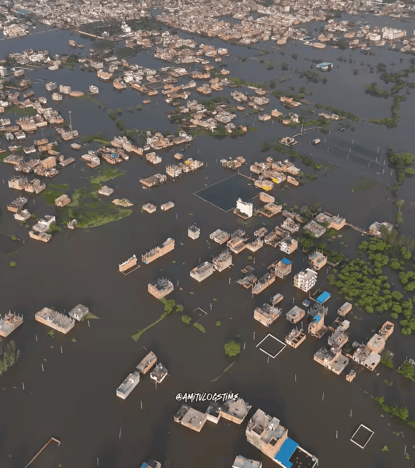
(Feature Image: A large part of residential areas witnessed severe flooding in first week of Oct. 2026 in Fazullaganj of Lucknow after heavy rains and flood in Gomti river. Source: Screenshot of FB post)
Two informative reports by Amal Chandra and Venkatesh Dutta in Down To Earth this week have once again highlighted serious gaps in India’s disaster management system. While our forecasting and response have improved in some cases, the number of disasters has also increased sharply. We often fail to understand the exact chain of events and remain reactive until the last moment. A key problem is that our system continues to focus more on response than prevention and lacks a holistic approach to disaster risk reduction.
As both reports show, decisions taken before, during and after development projects can increase disaster risks. Disaster preparedness must therefore begin with effective risk reduction measures at the planning stage across all sectors, including housing, roads and railways. The recent Gomti floods in Lucknow demonstrate how the piecemeal destruction of drainage systems, waterbodies and river floodplains can turn flooding into a serious and avoidable disaster.
There are several other reports here which raise concerns over other potential disasters which we are grossly overlooking. The dumping of construction debris into Himalayan rivers has and can aggravate the impacts of cascading disasters. The slow-onset disasters are equally concerning. The presence of chromium contamination of water sources in cities across the Godavari and Ganga basins is a serious problem that could have been prevented.
Hence, the citizen concerns and resistance against big interventions related to land, rivers, forests should be recognized as part of disaster prevention rather than dismissing them as obstacles to development.
However, it is disappointing to see that developmental agencies continue to operate in business-as-usual manner. The disaster management authorities have also failed to ensure any effective course correction. So, the question to ask here is how long will India remain trapped in a cycle of firefighting, blame and response? Can we afford to keep neglecting prevention until even bigger disasters strike?
DISASTERS
India cannot rescue its way out of disaster risk The real question is whether India can move from managing disasters efficiently to preventing its development choices from manufacturing disaster risk in the first place. A flood becomes catastrophic not simply because rain is heavy, but because wetlands have been filled, drainage channels narrowed, floodplains built over and housing pushed into unsafe land. A heatwave becomes more lethal when neighbourhoods lack trees, ventilation, drinking water and thermally suitable housing.
A landslide becomes a disaster when unstable slopes are cut without adequate geological assessment or drainage. This distinction matters. Hazards may be natural; disaster losses are heavily shaped by political, economic and planning decisions. India illustrates the problem vividly because it is simultaneously urbanising, building infrastructure and experiencing a changing climate.
If tomorrow’s housing, roads, drainage systems, power networks, hospitals and transport corridors are constructed using yesterday’s assumptions about rainfall, temperature and flooding, India will lock vulnerability into assets expected to survive for decades. Disaster risk reduction therefore cannot remain a department that enters the picture after urban planning, housing, road construction and environmental approvals have already created the risk. It has to become a test applied before investment is authorized. (Amal Chandra)
Lucknow’s floods are man-made The city must also assess the cumulative impacts of the Gomti riverfront, the Green Corridor, embankments, roads and surrounding urban expansion. No single project should be examined in isolation from the river system it modifies. The choice before Lucknow is clear: continue spending public money managing the consequences of ecologically unsound development, or restore the natural systems that have regulated water for centuries.
The problem extends beyond Lucknow. On August 7, 2026, the Ministry of Jal Shakti issued the River Ganga (Rejuvenation, Protection and Management) Authorities (Second Amendment) Order, 2026, which was published in the Gazette on August 10. The amendment introduced the category of an active floodplain, defined with reference to a one-in-five-year flood, and divided the broader floodplain into active, regulatory and warning zones extending through the 100-year flood extent. It also removed the earlier reference to a ‘construction-free zone’ from the relevant provisions.
These changes raise serious concerns about the future protection of river space and the scope for development in flood-prone areas. Removing an explicit construction-free safeguard and relying on zonal regulation creates legitimate questions about how effectively vulnerable river spaces will be protected. At a time when cities need to restore wetlands, protect drainage systems and give rivers adequate space, weakening clear safeguards against construction risks moving policy in the opposite direction.
For the Gomti, this concern is particularly significant. The river has already experienced substantial urban modification, including the restriction of parts of its floodplain through riverfront development. The priority should be to protect the remaining floodplain and restore hydrological connectivity, not create further pressure for construction. (Venkatesh Dutta)
The 2025 report of the UPSDMA also identifies inadequate drainage and encroachment on floodplains and wetlands in the Gomti basin as major factors aggravating flooding. Therefore, the next phase of flood management in Lucknow should not focus solely on building higher embankments. The city must also decide where the Gomti will be allowed to spread, which areas will be preserved as floodplains, which old ponds and waterways will be protected, and how the natural connection between the river and groundwater will be maintained. The current flooding of the Gomti reflects the changing relationship between Lucknow and its river. The growing gap between attempts to control the river and its natural behaviour becomes evident during every major flood.
HYDRO POWER PROJECTS
HRA demands dialogue on SUMP Expressing serious concern over the escalating tensions in Siang and Upper Siang districts in connection of the proposed Siang Upper Multipurpose Project (SUMP), the Human Rights of Arunachal (HRA) has appealed to the state govt to immediately withdraw the additional paramilitary forces and police personnel deployed in the project-affected areas, initiate confidence-building measures, and engage in meaningful dialogue with the affected communities.
SUMP protest continues Yingkiong, the headquarters of Upper Siang district, saw yet another protest rally against the proposed SUMP on Oct. 13 as people from several villages gathered for a peaceful rally and meeting. Seemingly bowing to public pressure, the govt granted a relaxation of the prohibitory orders under Section 163 of the BNSS, allowing a peaceful protest against the proposed SUMP to take place. The restrictions had originally been imposed in Yingkiong for 30 days starting October 11.
NHPC deploys Rs 10.9-cr PR blitz to shape Siang narrative Several questions arise regarding this PR campaign run by Concept on behalf of the NHPC. Who were the local influencers and community leaders engaged under the contract? Which NGOs and media organisations were involved, and what activities did they undertake? Were the proposed community events conducted as specified? What digital content and media engagements were produced?
What exactly did the separately identified engagement with prominent national journalists involve? How much money was paid to journalists and social media influencers to develop positive content related to the SUMP? How much of the original Rs 8.73-crore contract was paid out? What payments were made under the extension, and what supporting records were certified by the NHPC officials? In 2007, the state government took a Rs 225 crore loan from the National Hydroelectric Power Corporation (NHPC) to revive the Apex Bank. While the bank has not seen much improvement, the loan is yet to be returned.
CIAL’s Arippara success ignites calls to revive 122 small HEPs Since its commissioning in October 2021, Cochin International Airport Ltd (CIAL)’s small hydel project in Arippara has generated nearly 65 million units of electricity. This highlights the potential of small hydel projects in Keralam, where 122 such projects with a combined capacity of 664 MW have remained stalled for years. If they are revived and entrusted to district panchayats, district cooperative banks and private players, the projects could add hundreds of megawatts to the state’s generation capacity within two to three years, pointed out Jacob Jose, a former project manager of the Pallivasal Extension Scheme. He has also called for redesigning small hydel projects to combine them with solar power to improve viability.
Arippara offers a working example of the contribution such projects can make to state’s internal power generation. The project’s performance comes at a time when Keralam continues to depend heavily on electricity purchased from other states to meet its demand. He dismissed Kerala State Electricity Board (KSEB) officials’ contention that small hydel projects have a low return on investment. Among the stalled projects are Mankulam and Pambar, each with a proposed capacity of 40 MW, Achankovil (30 MW), Bhoothathankettu and Chinnar (24 MW each), and Kakkadampoyil-I (20 MW). Though a short-term agreement with the Himachal Pradesh Electricity Board for 600 MW during peak hours has helped the KSEB withdraw power cuts, depleting dam storage and the threat of El Nino continue to raise concerns.
Lower Sileru set to become AP’s second-largest HEP The expansion, taken up at an estimated cost of ₹536 crore, will increase the project’s installed capacity from 460 MW to 690 MW, bringing it closer to the 770-MW Srisailam Right Bank Hydroelectric Station, which currently ranks first in the state. AP Genco director (hydel) Sujay Kumar said power generation from the fifth unit was scheduled to begin in Nov, while the sixth unit was expected to be commissioned in March. Once both units become operational, Lower Sileru will emerge as a major contributor to the state’s hydropower capacity.
DAMS
Can damming tributaries revive the river? In fact, the Kishau project is part of a wider pattern of dam-building across the Yamuna basin. The 204 m tall Lakhwar dam is already under construction on Yamuna in upper basin. The other major tributaries in lower basin including the Chambal, Betwa, Ken are also under threats from extensive dam development projects. The relentless dam-building spree across the basin is bound to have serious repercussions for the Yamuna’s ecological integrity and undermine efforts to revive or ‘clean’ the river.
If Yamuna rejuvenation is the genuine objective, the focus must shift to demand-side water management issues. Rainwater harvesting, protecting & harnessing local water resources, adequately treating & reusing sewage, adopting water-efficient cropping patterns & improving irrigation efficiency are far more sustainable and viable options. These measures must be given priority over further damming of the Yamuna and its tributaries.
INTERLINKING OF RIVERS
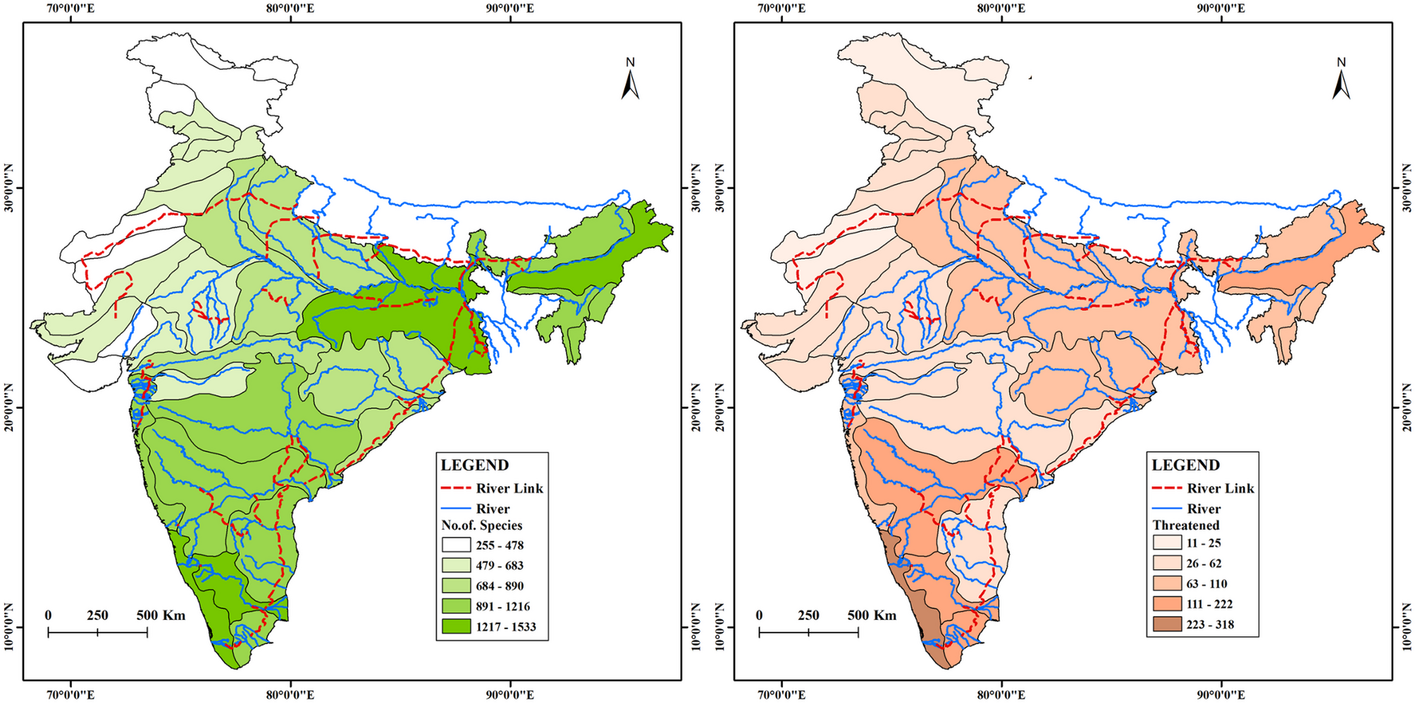
River interlinking may cause biodiversity may take a new turn India’s river linking proposals seek to address water distribution, agricultural productivity and flood and drought risks. However, the study argues that changes in hydrological connectivity could also affect the movement of invasive species and the survival of native freshwater life. This could negatively affect the health and ecological balance of freshwater ecosystems and threaten livelihoods, the very objectives that the plans aim at achieving. The article argues that river linking must be assessed beyond engineering promises, with greater attention to ecology, river health, livelihoods and long-term consequences. (Shreya Sarkar, Padmini Pani)
RIVERS
Chromium in Nashik water ahead of Kumbh Nashik-based environmental activist Rajesh Pandit Pandit said he and Parineeta Dandekar of the SANDRP visited the area and collected water samples for testing at an accredited laboratory. The samples were collected from the Nandini river system, which flows into the Godavari, near the Ambad industrial area in Nashik. The findings have raised concerns about the possible spread of industrial pollution into a river that will see a large influx of devotees during the Kumbh Mela. The festival centres around ritual bathing in the Godavari.
On Oct. 08, state minister Girish Mahajan, who is overseeing preparations for the Kumbh Mela, visited the area and spoke to Environment and Climate Change Minister Pankaja Munde about the findings. An official from Munde’s office said she had directed Maharashtra Pollution Control Board officials to take immediate and appropriate action against industries found to be polluting the area.
The findings have raised concerns about the impact of industrial discharge on the Nandini river and the Godavari. Several ghats along the Godavari are expected to receive large numbers of devotees during the Kumbh Mela, making water quality an important concern ahead of the event.
Toxic chromium in Nashik The Nashik Municipal Corporation (NMC) has screened 248 people suspected of having health problems linked to exposure to contaminated water. Of these, 109 were diagnosed with skin conditions or allergies. Residents of Dattanagar, in Nashik’s Ambad industrial area, have complained for nearly a month about yellow-coloured water coming from their borewells. An independent laboratory analysis commissioned by the SANDRP found hexavalent chromium concentrations nearly 1,000 times the permissible drinking water limit. The contamination has prompted the Maharashtra Pollution Control Board (MPCB) to order the closure of 17 electroplating units in the area, while authorities have prohibited residents from using groundwater.
According to SANDRP’s Oct. 8 report on this issue, the hexavalent chromium levels in Ambad’s groundwater are equal to one of the world’s worst contamination cases, exceeding even the levels in the infamous 1996 Erin Broncovich case.
The Nashik MIDC is home to 80 chrome-plating, zinc-plating, and powder-coating industries, which are factories that release chromium through discharge. According to a map prepared by SANDRP, the discharge is released into nalas in Ambad, which then join the Nandini River, a tributary of the Godavari. “This is a public health emergency, and it’s not just one company—there are many industries responsible for this pollution,” said Parineeta Dandekar, an associate coordinator with SANDRP. “Around 20,000 people live here, exposed to this groundwater, and millions more will arrive for the Kumbh Mela too.”
SANDRP’s report also demanded that the municipal authorities should deploy health camps, conduct forensic inspections of all MIDC units, and test the Nandini and Godavari Rivers for contamination.
SANDRP, which arranged the groundwater testing, said the contaminated water was also entering the Godavari through a local drain. The organisation called for tests of the Nandini tributary and the Godavari downstream of the contamination point to establish how far the pollution had spread. The extent of contamination in the river system therefore remains to be established.
A special health check-up camp organised by the NMC in Dattanagar, adjoining the Ambad MIDC area on the city outskirts, has found 90 residents suffering from skin-related ailments amid concerns over groundwater contamination in the locality. The camp was held at Tuljabhavani Temple in Dattanagar on Wednesday, where a total of 149 residents underwent medical examination. Out of the 90 patients diagnosed with skin ailments, 62 were found to have moderately severe symptoms, 26 had mild symptoms and two were identified with severe skin conditions. All patients were provided medicines and treatment free of cost.
With the identification of these 90 additional patients, the total number of people found to be suffering from skin ailments has gone up to 407. This includes 109 cases detected during OPD services at NMC’s Urban Primary Health Centre in Dattanagar and another 208 patients identified during a recent health survey conducted by the civic body’s health department.
A survey by NMC launched after complaints of discoloured groundwater and health problems, covered 8,887 households and 34,399 residents. Of the 229 borewells mapped in the area, 45 were found to be discharging yellowish contaminated water. The findings come amid alarming evidence of chemical contamination. Groundwater samples collected by Maharashtra Pollution Control Board (MPCB) detected chromium concentrations of 45 ppm in two samples, nearly 900 times higher than the permissible drinking water limit of 0.05 ppm.
Tamirabharani or Porunai river is now a ‘legal person’ The Madurai Bench of the Madras High Court has declared Tamil Nadu’s Tamirabharani (Porunai) river a deity, thereby granting it legal personhood to curb pollution from funeral rites and waste dumping. This ruling, which imposes protective conditions on state officials, marks a significant revival of India’s eco-centric Earth Jurisprudence after earlier judicial setbacks. (Manjeri Subin Sunder Raj)
Discussion on dry land rivers Amid climate change, increasing human activities and growing water demand, researchers, scientists, policymakers and other experts from across the country will gather in Bhopal to understand dryland rivers and explore measures for their conservation. The Indian Institute of Science Education and Research (IISER), Bhopal, will host XeroFluvia: A Conference on Dryland Rivers from December 14 to 16, 2026.
Organised by the Department of Earth and Environmental Sciences at IISER Bhopal, the conference will provide a common platform for researchers, river experts, practitioners, policymakers and students. Its objective is to develop new approaches to understanding, monitoring and managing dryland rivers amid changing climatic, environmental and socioeconomic conditions.
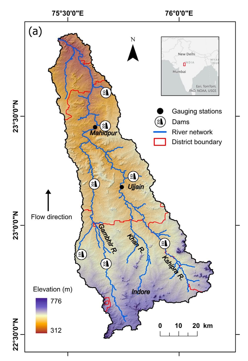
Dynamics of Hydrological (Dis-)connectivity As per this study, the once-perennial Kshipra river has experienced a major decline in hydrological connectivity with longitudinal connectivity falling from about 95% in the 1960s to nearly half by the early 2000s. It finds the dams, urbanisation, catchment land-use changes, groundwater fluctuations and climate factors as main reasons for disrupting river flows, floodplain connections and groundwater contributions leading to increased dryness and loss of riparian vegetation.
Sikkim HC bans muck dumping in Teesta Teesta River Muck Dumping linked to the Sevoke-Rangpo Railway Project has been prohibited by the High Court of Sikkim, which has directed IRCON and its contractors to stop disposing of excavated soil, mud and construction debris into the river. The court has also instructed the Namchi District Collector to investigate whether such dumping has affected the Teesta’s natural flow.
Beyond preventing further dumping, the High Court has sought an examination of whether the disposal of construction waste has already altered the Teesta’s natural flow. The District Collector must investigate the matter and, if any disturbance is established, identify measures necessary to address its effects. The High Court has fixed November 17, 2026, as the next date of hearing, when the District Collector’s findings on the alleged dumping and its impact on the Teesta are expected to come under consideration.
4 factories shut in Bidar over river pollution The district administration has ordered the closure of four factories in the Humnabad industrial area following directions from rural development and panchayat raj minister and Bidar district in-charge Eshwar Khandre over allegations of river pollution. Khandre had directed immediate action after sustained public protests against industries allegedly discharging chemical effluents into the Guruganga and Manjra rivers.
According to the minister, toxic chemical waste released from certain factories in the Humnabad industrial area into the Manikanagar stream and subsequently into the Guruganga and Manjra rivers polluted water sources and created a foul stench. Residents alleged that the contamination had adversely affected both human and livestock health. The issue triggered rallies, meetings, protests and awareness campaigns under the banner of “Save Guruganga”.
Commercial infrastructure on Balason riverbed The NGT on Oct. 06, directed the constitution of a joint committee to examine allegations of unauthorised and illegal structures, buildings, embankments and camping facilities allegedly erected by Balason Blues Resort and Camping at Damfetar, Dudhia, in Kurseong circle of Darjeeling district, West Bengal. The committee has been directed to submit its report within two months. The tribunal will next take up the matter on December 8, 2026.
The applicant submitted that the Balason river basin at Dudhia is a highly dynamic, ecologically fragile and geomorphologically vulnerable ecosystem that cannot withstand permanent concrete construction, riverbed excavation and channel constriction without triggering serious hydrological failures.
Microplastics in J&K’s waterbodies Plastic pollution is now visibly entering the region’s lakes, rivers and food chain. Microplastics in Dal, Anchar, Wular, Mansar, the Jhelum, Basantar, Ujh and Chenab show that J&K’s freshwater systems are already carrying the consequences of careless plastic use. If the government waits until microplastics are routinely found in every fish sold in local markets, it will be responding to a crisis that has been visible for years in choked drains, plastic-lined riverbanks and unmanaged municipal waste. (Anuj Kumar Verma)
Villagers protest Ghaggar pollution Villagers and farmers from around a dozen villages staged a protest outside the SDM office on Oct. 13 against the discharge of untreated sewage and allegedly chemical-contaminated water into the Ghaggar River. They submitted a memorandum to SDM Aditi Singhania, demanding an immediate halt to the discharge, 100% wastewater treatment at the STP and a permanent solution to the pollution problem.
The villagers alleged that untreated sewage has been polluting the river for a long time, causing foul smells and raising concerns about serious health risks, including cancer, jaundice and respiratory diseases. They demanded a thorough investigation and accountability for the officials responsible. They warned that farmer organisations would intensify their protests if the administration failed to act promptly.
NGT takes note of The Hindu report on toxic Chromium laden water The NGT has taken suo motu congnizance of The Hindu report on groundwater contaminated by the hexavalent chromium and gaps in the effort in Uttar Pradesh. In an order of Oct 5, based on The Hindu report “Groundwater that grows yellow-green”, NGT has issued notices to 14 authorities including UP Chief Secretary, NMCG, AIIMS among others. Even after years, the clean up of toxic waste has remained slow and inadequate. Many areas with contaminated groundwater are not even part of the affected areas identified in the petition, showing that the problem could be larger.
Villagers Resist NTPC’s Proposed Nuclear Plant in UP In a letter sent on October 17, 2026, to Ujjwal Raman Singh, Prayagraj MP, local resident Ram Chandra, writing on behalf of the (NMKS), seeks his support for their demands of the government: Relocate the nuclear power plant to a less densely populated area. Conduct public stakeholder consultations. Commission an independent, third-party environmental audit. Assess the impact and risks to the River Ganga and Prayagraj city. Conduct a socioeconomic and spiritual impact assessment of the project. Ensure that the local police do not use violence against residents.
Examining State Accountability for Industrial Pollution of the Ganga This study examines whether the State can be held responsible for failing to meet its constitutional and legal duty to protect the Ganga from industrial pollution based on Article 21, which provides the right to live with dignity that includes the right to a clean and healthy environment and Article 48A, which imposes a duty on the State to protect and improve the environment.
The study also analyses the State’s duty to regulate industries, monitor industrial waste discharge, and effectively implement environmental standards and laws. This study maintains that the State has a primary constitutional and legal duty to prevent and control industrial pollution of the Ganga and any failure to regulate pollutant discharge constitutes a breach of constitutional duty.
SC flags floodplain definition in Yamuna clean-up plan Supreme Court on Oct. 14 said a Yamuna clean-up plan, drawn up by a high-powered committee headed by the Union home secretary, leaves the definition of its floodplain unsettled and offers no rehabilitation scheme for those living on it. A bench comprising Justices Manoj Mishra and Manmohan raised the concerns during a presentation by the court-appointed committee to draw up a comprehensive action plan for the river.
The judges asked why the definition of active floodplains used in River Ganga (Rejuvenation, Protection and Management) Authorities Order, 2016, was different from Delhi Master Plan 2041 and said such categorisation could open the door to fresh litigation. They also asked why the plan contained no relocation and rehabilitation scheme for unauthorised structures built in critical zones along the river.
SC seeks clarity on Yamuna plan A bench of justices Manoj Misra and Manmohan, in an order dated September 22, noted that a committee had prepared the Yamuna Action Plan following the court’s August 12 order and submitted it for consideration. The court noted that the status report accompanying the plan said there was no proposal to remove or relocate encroachments and unauthorised structures on riverbeds, floodplains or drains in Delhi.
The plan states that 1,799 unauthorised colonies have been identified and an integrated sewerage system is being developed for them. “About 73% of the work has been completed, while the rest is at various stages,” the order stated. The bench, however, sought details on how many of these colonies are located on floodplains to assess whether the action plan would achieve its stated objective. The court also sought an explanation on the classification of floodplains under the Master Plan for Delhi-2047.
The bench also directed a representative of the Ministry of Home Affairs to make a presentation on the Yamuna Action Plan and the steps proposed under it. The presentation will be held on October 7 at 4pm, the court said. The matter has been listed for further hearing on November 4, 2026. The court directed that a report or affidavit addressing the issues raised be filed before the next meeting.
Delhi govt to conduct surveys of 48-km Yamuna stretch The Delhi government will undertake topographic and bathymetric surveys of the entire 48-km Yamuna stretch from Palla at the Delhi-Haryana border to Jaitpur at the Delhi-Uttar Pradesh border to map the riverbed, identify clogged sections and assess changes in the river’s course, senior government officials said.
The Irrigation and Flood Control (I&FC) department invited bids on October 1 to undertake two types of surveys of the river from Palla to Jaitpur. The Yamuna surveys are likely to cost around ₹80 lakh, and the agency will be given eight months to complete the exercise. Last year, the Delhi government had stated that it intended to undertake the first dredging of the Yamuna riverbed, for which it would approach the NGT. The proposal was aimed at reviving the river’s natural flow, easing pressure on regulator drains and enhancing flood resilience in low-lying neighbourhoods along its banks. Dredging is an exercise usually done for smaller water bodies such as canals and lakes and involves the excavation of accumulated silt, sludge and solid waste from the riverbed.
CPCB finds solid waste, untreated sewage in major drains Central Pollution Control Board (CPCB), which assessed the pollution in the Yamuna in Delhi between May 2025 and April 2026, found solid waste at 32 locations, while tapping arrangements in 11 drains were either inadequate or not functioning for several months.The joint monitoring was initiated under NMCG, in coordination with CPCB, DPCC and DJB.
The report identified inadequate tapping arrangements in 11 drains. In seven, the systems were not working. In one drain, the arrangement was not operating and in three, the systems were functional but overflowing. Eight of these drains were on the Sahibi network and three in the Shahdara drain network.
The report recommended restoring non-functional tapping systems, ensuring regular cleaning of drains, preventing solid waste dumping and scientifically relocating desilted material from drain banks to dedicated sites. The report said UP and Haryana should carry out a survey for identification of pollution sources of drains in their jurisdiction and implement remedial measures for abatement of pollution of the Yamuna.
Dark flows Yamuna While promises to clean the river keep flowing downstream, including a deadline set this June to restore the river’s health by 2027, its water tells a murky tale. Even after years of planning, there is no capacity to process about 30 percent of the capital’s sewage. That damning planning failure is made worse by periodic outage of some of the city’s 37 sewage treatment plants. The least the government can do is put out clear advisories for people not to bathe or fish in the polluted river.
Delhi’s dense urban landscape extends along the banks of Yamuna Acquired on 10 September 2026 by one of the Copernicus Sentinel-2 satellites, this false-colour image shows built-up areas in purple and magenta tones and vegetation in bright green. The dark waters of the Yamuna River run through the image from north to south-east, and the runways of the Indira Gandhi International Airport are visible in the south-west of the image.
Floodplain in Noida bears dangerous levels of nitrate contamination In at least two samples of the underground water tested by Central Ground Water Board in 2025, these levels were almost double the permissible limits. Data released by the Lucknow office of CGWB reveals that nitrate levels have often breached the safe limits in different parts of the district over the years. Responding to an RTI application filed by environmentalist Amit Gupta, the CGWB office has released the report of tests conducted at 13 sites in GB Nagar during 2025, while the study for the current year is in progress.
According to the data released for the years 2019, 2021, 2022, 2023, 2024 and 2025, the tests were conducted at different numbers of sites in the district–the maximum being 13–and only twice–in the years 2023 and 2025–were samples tested from all these sites. At both the sites where the nitrate levels breached safe limits in the 2025 study, even higher concentrations were reported during the 2023 study, and they were found to be 160 in Choroli, Jewar and 72 in Dadri.
FISH, FISHERIES, FISHERFOLKS
Climate warming accelerated freshwater habitat fragmentation Abstract: Here, using weekly water temperature data (1976–2099), we assess the vulnerability of 9,809 freshwater species to short- and long-term thermal extremes and show that gradual warming can trigger abrupt thermal exposure. Tropical regions experience a high proportion of species at risk, whereas non-tropical regions face severe thermal extremes. We introduce the concept of thermal fragmentation exposure to understand how heterogeneous warming fragments freshwater habitat, thereby amplifying local extinction risks. Around 63% of riverine fish will experience more persistent thermal barriers under a high-emissions scenario, with thermal fragmentation accelerating over time. These findings underscore the urgent need for targeted conservation strategies to safeguard freshwater fish biodiversity.
New freshwater fish species discovered in Western Ghats A new species of freshwater fish has been described from a tributary of the Krishna River in Maharashtra’s Western Ghats, while a second species, originally discovered by British ichthyologist Francis Day in 1869 and forgotten for over a century, has been brought back to attention. The newly described species, Opsarius geminus, was collected by Balaji from the upper reaches of the Koyna River, a major Krishna River tributary in Satara district. Its name, geminus — Latin for “twin” — reflects its striking resemblance to Opsarius barna, a related species found in the Ganges-Brahmaputra river system.
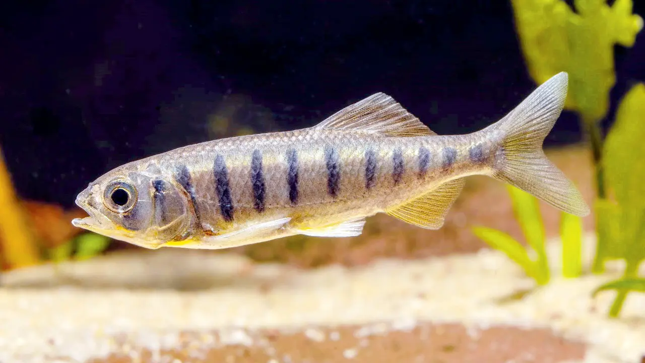
The authors said fish previously identified as Opsarius barna in surveys of the Krishna River in Maharashtra are most likely misidentified specimens of the newly recognised species, highlighting how closely related fish can be confused in the field. The team also revalidated Barilius papillatus, first described in 1869 from the Cossye River in Odisha. Long misclassified as Opsarius barna, researchers used fresh samples from the Mahanadi River and historical specimens from Sydney’s Australian Museum to confirm its distinct identity.
Maharashtra’s floating-solar push leaves fishing communities uncertain At Omkareshwar in Madhya Pradesh, India’s largest floating-solar project, fisherfolk say they lost access to traditional fishing grounds after the project came up, affecting livelihoods. At Ujani, that experience has become part of what fisherfolk fear: not opposition to renewable energy in the abstract, but loss of access without adequate protection or compensation.
Ujani fisherfolk do not appear to have strong legal rights over the waters themselves. Access to fishing is largely governed through cooperatives and a licensing system, making their position vulnerable to changes in how the reservoir is managed. That vulnerability has sharpened with the proposed privatisation of fishing contracts.
More argues that Ujani should not repeat the problems reported at Omkareshwar. He calls for clear boat lanes and protection of fishing rights before construction begins. The question, then, is not whether Maharashtra should choose fishing or clean energy. It is whether it can design projects that recognise the reservoir’s existing users before adding a new, large-scale use.
Introduced fish thrive in Kashmir Native fish in the lakes and rivers of India’s Kashmir Valley are under increasing pressure from pollution, habitat loss, dam construction and other human activities, a recent review finds. These same threats are also likely giving exotic fish introduced to these freshwater habitats an edge, researchers say.
Mass fish death in Yamuna’s Wildlife enthusiast and conservationist Hemant Garg, who spotted the dead fish on Oct. 14 night, said thousands had been seen upstream, extending to Shank numbers 10, 11 and 12. Boatman Ranjan Mukhia said the water had developed a strong smell and the deaths were not confined to one stretch. Other boatmen upstream had also reported dead fish, he said, adding that carcasses had to be removed to prevent further deterioration in water quality.
Bhim Singh Rawat, a Yamuna activist and member of the SANDRP, said mass fish deaths are usually reported in summer, when high temperatures reduce dissolved oxygen in water. “I can’t recall the last such episode in winter months. The possibility in this case could be untreated industrial effluents,” Rawat said, pointing to Drain 2 from Panipat, Drain 8 and a drain in Burari as possible sources of industrial discharge. He also said raw water flow in the river had remained low despite the monsoon.
Yamuna activist Pankaj Kumar said he had written to the Delhi Pollution Control Committee, seeking urgent intervention. Mass fish mortality is a critical indicator of ecological stress, he said, citing low dissolved oxygen, high biochemical oxygen demand (BOD) and toxic industrial effluents as possible causes. If toxic substances are present in quantities sufficient to kill fish, the water being drawn downstream at Wazirabad for drinking could pose a public health risk, Kumar said.
Bhim Singh Rawat, SANDRP, said the recurring mass mortality of fish in this stretch was concerning. “This latest incident, occurring just after the monsoon season, is particularly unusual and poses a serious threat to the river’s remaining aquatic biodiversity,” he said. Several drains in Haryana carry wastewater from industrial and urban areas into the Yamuna. These include the Dhanaura drain and drains No. 2 and 8, which receive wastewater from areas including Karnal, Panipat and Sonipat.
Bhim Singh Rawat, SANDRP said the recurring deaths in a “relatively cleaner stretch” were deeply concerning. “If this is from pollution, then adverse effect may impact Delhi’s potable water as well,” he said, calling for an investigation to find the exact cause. Rawat flagged restricted environmental flows and untreated discharges from drains, including Drain no. 2 in Panipat and Dhanaura drain in Haryana, as possible contributors. He said industrial pollution could also be a factor.
A similar incident was reported near Burari in May last year, when visuals showed thousands of dead fish floating in the river. At the time, locals had attributed the deaths to chemical waste allegedly discharged from Haryana, while reports pointed to high pollution levels. In May this year, hundreds of fish also died at Sanjay Lake in East Delhi amid a heatwave and falling water levels.
Bhim Singh Rawat of SANDRP expressed concern, saying that the incident was surprising as it occurred just after the monsoon in the stretch of the Yamuna upstream of Wazirabad. He pointed out that despite water releases from Haryana’s Hathnikund Barrage, the Yamuna does not maintain an adequate minimum flow. Meanwhile, untreated chemical waste from drains in Karnal and Panipat continues to flow directly into the river.
The New Delhi Nature Society shared videos of the incident on social media and referred to local claims that chemical waste was being discharged from Haryana. Experts have warned that thousands of devotees will take a dip in the Yamuna during the upcoming Chhath festival, potentially exposing them to health risks.
Bhim Singh Rawat, SANDRP called for stricter pollution control and adequate environmental flows, questioning the effectiveness of multi-crore river-cleaning efforts by the Delhi and Haryana governments. The incident has also raised concerns ahead of Chhath, when thousands of devotees are expected to visit the river. Contact with polluted water could pose health risks to those entering it. He also identified industrial pollution as a possible cause of the fish deaths. However, the pollutants responsible and their sources can be identified only after an investigation.
The fishermen have been witnessing such fish deaths for the past three years, sometimes every two or three months, and sometimes more frequently, every two weeks. They claim that the water flows down from Panipat, Sonipat, and often they even get calls from fishermen upstream to warn them that fishes in their area have already begun dying out. Activists are particularly alarmed because such incidents come against the backdrop of the Delhi government’s claims that the Yamuna had been cleaned enough that people could sip its water during rituals of Chhatt Puja.
Mass fish death in Yamuna in Baghpat A mass fish death incident has occurred in Yamuna river in Baghpat on Oct. 13 night, reportedly due to polluted water. Their bodies were found along the riverbanks on Oct. 14 morning. After learning about the incident, hundreds of people from Eidgah Colony and Islamnagar Colony reached the site and collected the dead fish in sacks to take them away. Local residents alleged that fish had died in the past as well because chemically contaminated water was discharged into the Yamuna. They demanded that the drains discharging into the river be closed.
Mass fish death in Doddagubbi Lake in eastern Bengaluru The Doddagubbi Lake in eastern Bengaluru’s Mahadevpura constituency became a graveyard on Oct. 03 with thousands of fish found dead across the 125-acre water body. No official reason has been given for fish death, while an activist’s suspicion of sewage dumping remains unverified. The activist, KC Mahesh, a regular walker at the lake, said, “I suspect that since this is a long weekend, some unscrupulous builders have taken advantage because officials will not be there, and let raw sewage into the lake.”
Doddagubbi Lake full of maggots Nearly a week after mass fish-kill, Doddagubbi Lake is stinking because civic officials failed to dispose of the dead fish; as a result, the decaying fish have become a breeding ground for maggots and causing a bad odour in the surrounding area.
Raghunandan, JP, a resident and KRS Party functionary, said that last week, following heavy rainfall, leachate from Mitganahalli yard flowed down into the lake and caused contamination, and still no one came and cleared it. The activist also stated that under Shubra Bengaluru, a fund of Rs 11crore was also allocated for lake development, and now, Greater Bengaluru Authority officials claim they have written to the minor irrigation (MI) department to take over the lake as it is the original custodian of the lake, but it is reluctant.
The Bengaluru Urban Fisheries Department Deputy Director Chikkanna stated that, due to pollution, almost all the fish have died and a cooperative society to help poor local fishermen community has suffered a loss. Anand Babu from Yellammadevi Mahila Meenugarara Sahakara Kshema Abhivrudhi Sangha, that has 82 members, said poor families were dependent on the fish catch of tipalia, katla and rohu, and the fish weighed from 500gm to 1.5kg, and entire aquatic life has been destroyed. “We have lost around Rs 20lakh due to mass fish kill,” said Babu.
Poor waterflow kills tonnes of fish in channel near Korattur More than a tonne of tilapia was found dead in a channel near Korattur Lake on Sept. 09, less than a month after an estimated four to six tonnes of fish washed up dead in the Kosasthalaiyar River near Ennore. Fisheries Department officials suspect the Korattur fish died after being trapped in stagnant water with low dissolved oxygen levels.
According to an official, the sluice gate of Korattur Lake was opened on Sept 7 as part of monsoon preparedness, allowing water and several fish to move into a channel which eventually leads to Retteri Lake. The gate was closed soon afterwards because of ongoing metro waterworks nearby. With the flow cut off, the fish remained trapped in the channel for a prolonged period, and officials suspect oxygen levels in the stagnant water fell. “If the sluice had remained open, the water would have continued to flow, and the fish could have reached Retteri Lake,” the official said.
SAND MINING
DSRs of Basti and Shamle cancelled In a significant order, the NGT on Oct. 09, directed that the District Survey Reports for Basti and Shamli districts in Uttar Pradesh be set aside. The tribunal noted that, in the case of Basti district, no replenishment study had admittedly been conducted before the District Survey Report was prepared.
In the case of Shamli district, although a replenishment study had been conducted, it was admittedly not placed before the State Level Expert Appraisal Committee and the State Environment Impact Assessment Authority, Uttar Pradesh, when the District Survey Report was approved in a meeting held on August 1, 2024.
The SEIAA, Uttar Pradesh, had “mechanically approved” the District Survey Reports of Shamli and Basti without ascertaining whether a replenishment study had been conducted before the reports were prepared, and whether the reports were based on material gathered and recorded in the replenishment study, the NGT order stated.
NGT to assess illegal mining in Betwa river The NGT central bench Bhopal directed the constitution of a three-member Joint Committee to assess allegations of illegal sand mining activities at the River Betwa located in District Vidisha. The court directed the Committee to visit the site and submit the factual and action taken report within six weeks. The State PCB was appointed as nodal agency for coordination and logistic support. The Tribunal further issued notice to the respondents and directed the applicant to take necessary steps for service to the respondents. The matter was accordingly listed for December 9.
The application was filed by a senior citizen who was interested in the protection and conservation of the environment within the meaning of the National Green Tribunal Act, 2010. It was claimed that the applicant has been pursuing this matter since August 21, 2024. Per the application, the illegal activities are taking place in Village Jonakhedi, Tehsil Kurwai, District Vidisha.
Desilting of Punjab rivers Due to floods in Punjab in 2025, a large quantity of silt was deposited in the state’s rivers, requiring desilting to prevent future flooding. The National Framework for Sedimentation Management, issued by the Union Ministry of Jal Shakti (water resources) July 12, 2023 provides that water bodies including rivers need to be desilted periodically after following the standard operating procedure.
The Department of Water Resources, Punjab, conducted a detailed exercise to identify sites where deposited silt obstructed the smooth flow of the flood waters. On October 15, 2025, the authority issued a notification identifying 85 sites for desilting. This was stated in the reply by Punjab Pollution Control Board before the NGT, October 6, 2026.
WETLANDS, LAKES, WATER BODIES
Illegal use of forest land and waterbody in Nayagarh The NGT on Oct. 06 directed the Principal Chief Conservator of Forests and Head of Forest Force, Odisha, to submit a response to a complaint concerning alleged unauthorised and illegal construction of a park and resort at Kotagada village in Nayagarh district, Odisha. The committee was directed to visit the site, examine the applicant’s grievances, involve the applicant and the representative of the project proponent, verify the factual position and suggest appropriate remedial action. The application alleged that the project proponent had cut trees over more than 1.5 acres of forest land. It also alleged that a waterbody measuring more than two acres had been illegally encroached upon.
Rajasthan’s Badopal Wetland Faces Conflict A wetland comprising 18 large water bodies in Badopal village of Hanumangarh district has become a source of conflict between conservation and agricultural livelihoods. Created nearly six decades ago when floodwater from the seasonal Ghaggar River was diverted into low-lying areas through the Ghaggar Diversion Channel, the wetland now supports fish, aquatic vegetation and more than 250 reported bird species.
However, water accumulation has caused severe waterlogging, locally known as sem, damaging farmland and affecting village infrastructure. Reduced rainfall, water retention at Haryana’s Ottu Headworks and the shrinking of the Ghaggar’s traditional flow area have also reduced water reaching the wetland.
In 2024, Rajasthan’s Forest Department initiated a process to classify 2,062.255 hectares of Irrigation Department land in Badopal Barani as deemed forest, following Supreme Court directions. Farmers fear that the proposed status could restrict cultivation and access to their fields, while the Irrigation Department has raised concerns about its implications for flood-control work.
RAMSAR WETLANDS
India adds two more Ramsar Wetlands India has added Sukhna Wetland and Sauj Jheel to the List of Wetlands of International Importance, bringing its total number of “Ramsar Sites” to 103. Located at the edge of the city of Chandigarh and at the base of the Outer Himalayas, Sukhna Wetland (Site no. 2602 on the “Ramsar List”) is a peri-urban reservoir that plays an important role in regulating sediment and water flows from the surrounding catchment. The wetland experiences seasonal fluctuations in water levels and supports a range of habitats, from open water to littoral vegetation, scrub and forest, providing habitat for diverse species.
-Sauj Jheel in the state of Uttar Pradesh (Site no. 2603) is a shallow lake surrounded by farmland in the floodplain of the Ganga River. It forms part of a larger network of wetlands, contributing to ecological connectivity in the wider landscape, and is close to Saman Bird Sanctuary (Ramsar Site no. 2413). The lake supports diverse wetland-associated vegetation, including the sacred lotus (Nelumbo nucifera) and the wild sugarcane (Saccharum spontaneum). These habitats provide nesting and breeding sites, as well as shelter and food resources, for a variety of animal species. Proposed management actions include a seasonal ban on fishing, restrictions on the use of fine-mesh fishing nets, and control of the access of cattle to the Site.
Sukhna lake faces challenges from sediment inflow and invasive plant species. Its management plan includes soil and moisture conservation to curb erosion, reduce sediment loads and periodically remove invasive vegetation.
Keoladeo’s water lifeline is running into trouble Spread across 28.73 square km in Rajasthan’s Bharatpur district, Keoladeo is one of India’s most important habitats for birds. It was declared a Ramsar site and a national park in 1981, and UNESCO declared it a World Heritage Site in 1985. But the wetlands that make the park an important habitat depend heavily on a steady supply of water brought from outside. A large part of the water supplied to Keoladeo comes from the Panchana Dam. Farmers in the surrounding areas also depend on the same water for agriculture, creating a conflict over its use. The park therefore faces a difficult situation: it needs water to sustain its ecosystem, while people living around the same river and dam depend on it for agriculture.
According to Assistant Conservator of Forests Bharatlal Sharma, Keoladeo National Park requires about 550 million cubic feet of water each year. But the park has little natural water of its own. “There are small rivers here and their catchment areas are also small,” said Chetan Kumar BV, Deputy Conservator of Forests at the park. The Chambal supplies about 62 million cubic feet – roughly one-tenth of the park’s annual requirement. “But it isn’t enough,” Sharma said. Most of the park’s water therefore reaches it through the nearby Ajan Dam, which is fed by Panchana.
When Panchana does not supply enough water, the park turns to the Govardhan Drain near the Haryana-Uttar Pradesh border. But this is not considered a suitable alternative: the drain passes through agricultural areas where pesticides are used extensively, and Kumar BV said the water could carry these pollutants into the park. Kumar BV said the capacity of Panchana Dam was tripled in 2003-04, allowing it to hold and regulate much more water. The park has since become more dependent on how water is stored and released from the dam.
Pallikaranai buffer zone shrunk by 96% The State Wetlands Authority has drastically reduced the proposed interim Zone of Influence (ZoI) around the Pallikaranai Ramsar wetland from 3,358 hectares to 128.19 hectares, a contraction of about 96%, raising questions over whether the revised boundary adequately accounts for the marsh’s wider hydrological connections. Madras high court will pronounce its verdict in the case on Oct. 14.
The authority said the revised interim zone covers parcels across 36 survey numbers that could potentially affect the hydrology of the Ramsar site. The exercise followed representations from landowners, developers and others, as well as a review of historical satellite imagery, drainage pathways, land use, infrastructure and hydrological connectivity. The proposed zone is an interim arrangement and not the final delineation, the authority clarified. The final boundary will be determined after scientific and cadastral exercises and ground-truthing under the Wetlands (Conservation and Management) Rules, 2017.
The Madras High Court on Oct 14 adjourned to Nov. 11, 2026 a batch of cases filed against a construction ban imposed by the NGT on a 1 km radius around the boundaries of the Pallikaranai marshland, a Ramsar site, in Chennai. First Division Bench of Chief Justice Sushrut Arvind Dharmadhikari and Justice G. Arul Murugan said, in the meantime, they would go through a report filed by State Wetlands Authority for declaring 36 survey numbers covering 128.19 hectares as an interim Zone of Influence (ZoI).
Large quantities of seaweed, dead fish wash ashore along Gulf of Mannar The beaching of a large amount of seaweed and dead fish along the Gulf of Mannar coast has raised concerns among fishermen, who have sought an immediate study to determine whether unusual marine conditions. Experts state that the phenomenon occurs usually during monsoon season but this year started earlier.
Large quantities of Padina seaweed, locally known as fan-shaped algae, have been washing ashore along the Pamban-Kundhukal-Mandapam stretch near Rameswaram. The accumulation has also caused a foul smell along parts of the coast, while patches of seawater have turned muddy in the shallow areas of the sea.
Salt bunds in CRZ area of Kachchh being demolished The process of demolition of salt bunds of Whitevibe Salt Private Limited which are in existence in coastal regulation zone (CRZ), Lakhpat taluka, Kachchh district, Gujarat area has stated, the NGT was informed, October 12, 2026. The project proponent started the demolition work of the bunds which will take around eight weeks because the area is very large.
In its report dated October 8, 2026, the Gujarat Coastal Zone Management Authority (GCZMA) stated that the unit has demolished 100-110 feet in length of the bund at three locations. Further, demolition work on the bund is ongoing at another location. The counsel for the applicant has also expressed satisfaction with the work of demolition of illegal bunds which is in progress and the same would be completed very soon. The tribunal stated that the project proponent must adhere to the timeline it set for clearing the entire bund.
Solid waste dumping in Upper Lake, Bhopal Bhopal Municipal Corporation (BMC) was directed by the NGT on Oct 12 to ensure that no soil, earth, construction debris or other solid material is deposited/dumped within the full tank level (FTL) area of the Upper Lake affecting the storage and ecological character of the wetland.
Water hyacinth and silt removed from the Upper Lake should be completely dewatered and promptly transported from the bank to a designated site for appropriate disposal, ensuring that the removed biomass is not allowed to reenter the waterbody or accumulate along the lake edge and there should not be any encroachment within the wetland or prohibited zone or no constructions zones and the Wetland Rules, 2017 must be strictly complied with directed the bench of Justice Sheo Kumar Singh.
WATER OPTIONS
How bugs confirm the health of Uttarakhand’s Rawasan stream A first of its kind study uses stoneflies, caddisflies and mayflies as natural bioindicators to show that Uttarakhand’s Rawasan stream remains clean, resilient and ecologically healthy overall despite minor stress.

Reviving mountain springs in Uttarakhand A district workshop in Almora highlighted how community capacity building and local knowledge can secure Himalayan water resources, as demonstrated by a young woman who mastered hydrogeology to restore her village spring.
NIT-Rourkela team uses peel of jackfruit to remove groundwater fluoride The research team comprises Prof Susmita Mishra of the Chemical Engineering department and research graduate Pratima Minz. Prof Mishra said, “The key idea behind this technology is to use an agricultural waste material as a resource for water purification. We prepared activated carbon from discarded jackfruit peel and modified it with zirconium to improve its ability to capture fluoride from water. The material showed promising results in fluoride removal in laboratory tests.”
The research team recorded removal efficiencies exceeding 90-97 per cent in 10-20 minutes under test conditions. About real-world applications of the technology, Prof Mishra said, “In the long term, the technology could contribute to decentralised water treatment solutions for communities in fluoride-affected regions, subject to further testing and validation.” The research team plans to developing a physical prototype next and assess practical deployment, long-term performance and operational costs of the developed material.
GROUNDWATER
The unintended consequences of Punjab’s groundwater Act Punjab’s groundwater level has been declining at an average rate of 0.43 metres per year over the past two decades, posing severe water table challenges for the state. This is due to the Green Revolution, which replaced crop combinations with wheat and rice because of technological innovations, higher profits through MSPs and irrigation incentives. These water-intensive crops led to a huge depletion of the water table and soil fertility.
URBAN LAKES, WETLANDS
Mumbai’s mangroves, wetlands suffer Mangroves and wetlands face mounting conservation concerns as meetings of Bombay High Court-mandated committees are separated by months, thousands of hectares of mangroves await transfer to the Forest Department, and complaints of destruction remain unresolved. NatConnect Foundation has now approached Chief Minister Devendra Fadnavis, seeking urgent intervention to ensure that judicial directions translate into effective action on the ground. The environmental watchdog has pointed to prolonged gaps between meetings of the Mangrove Conservation Committee and the Konkan Wetland Conservation Committee, questioning the pace of oversight and compliance with conservation directions. The concerns arise even as the Chief Minister has repeatedly spoken of protecting Maharashtra’s mangroves and wetlands.
Can Mumbai afford to lose its mangroves? Though the Supreme Court has cleared the Rs 18,000-crore Versova-Bhayandar Coastal Road project, citizens’ groups, fishing communities, naturalists and environmentalists have been raising alarm.
Plastic waste chokes estuarine zones While beach clean-up drives are being undertaken to create awareness about environmental conservation, hundreds of tonnes of plastic waste accumulating in the ecologically sensitive estuarine zones and mangrove forests spread across river islands in Karwar remain largely unattended. A large share of the plastic waste and other garbage entering the sea is carried downstream through rivers. Driven by strong waves, the waste reaches and hits the shores. Much of it gets trapped among roots of mangroves in the estuaries, resulting in extensive accumulation on river islands. The Kalimata island in Karwar and several smaller islands in its vicinity have witnessed widespread waste accumulation. Locals say a similar situation exists in the estuaries of the Gangavali, Aghanashini and Sharavathi rivers.
Hebbal Lake NGT stops Karnataka from felling trees The NGT which was hearing a case pertaining to the felling of 1,128 trees for the project, issued orders restraining the state govt from felling trees. The orders are not limited to Hebbal Lake and surrounding areas, but also to the entire stretch of the proposed tunnel road project, till the original application is disposed of. The trees to be felled belong to over 70 species. The next hearing is on December 15.
Migratory birds set to arrive but ‘drying’ Najafgarh wetland not in shape to host them Major parts of Najafgarh wetland, spread across Delhi and Haryana, are almost dry. Most of it “could dry up within a month”, potentially affecting the diversity and numbers of birds that depend on it, ecologist and ornithologist TK Roy has warned.
Roy’s observations during a field visit to the wetland on Oct 7 come amid concerns over the loss of feeding grounds and habitat just as the winter migration season begins. The wetland — a key wintering ground for migratory waterbirds in Delhi NCR —was fully covered with water in Aug following good rainfall. However, large-scale illegal fishing was taking place at the time, disturbing waterbirds and prompting greater flamingos to leave the area. As water levels receded, villagers began cultivating the dried-up portions and large-scale fishing stopped.
URBAN WATER
‘70% of Hyd’s annual groundwater reserve used’ The Core Urban Region (CURE) is faced with a severe water crisis, with nearly 70% of its annual groundwater resources already extracted, according to the latest India-Groundwater Resource Estimation System (IN-GRES) assessment for 2025-26. IN-GRES is a platform developed by the Central Ground Water Board (CGWB) that analyses key groundwater metrics at the state and central level
Hyderabad faces a reported water deficit of 150 MGD as groundwater levels decline and monsoon rainfall remains deficient. HMWSSB supplies 585 MGD against a projected demand of 735 MGD, prompting plans for infrastructure upgrades and long-term supply projects. The HMWSSB plans to cut water supply to IITH, BHEL, Ordnance Factory and BDL amid falling levels in Singur reservoir. With storage at 3.70 TMCft, officials have also restricted supplies to beverage firms and stopped deliveries to chemical companies recently. With daily water tanker bookings in Hyderabad rising from the usual 3,500 in October last year to around 7,000 this year, the Telangana govt has urged households to reduce water consumption by at least 20% and conserve electricity amid concerns over El Nino and adverse weather conditions.
Mumbai’s groundwater under threat amid drought With parts of Maharashtra facing drought-like conditions, a Central Ground Water Board (CGWB) study has found that nearly 35 per cent of Mumbai’s area is highly vulnerable to seawater intrusion into freshwater aquifers, raising concerns about the quality and future usability of groundwater. The study identified Fort, Shivaji Park in Dadar, Mulund East and Mahim among the areas where saline groundwater was encountered. It warned that excessive pumping could lower freshwater pressure and allow seawater to enter aquifers, making groundwater unusable even in areas where extraction levels are considered safe.
The findings are part of the CGWB’s 2025 Aquifer Management Plan, presented earlier this year by the Union Ministry of Jal Shakti’s Department of Water Resources, River Development and Ganga Rejuvenation. The assessment mapped aquifers across 603 sq km covering Mumbai city and suburban districts. The study found that shallow aquifers along the western and southern coasts are particularly vulnerable to saline intrusion. In the eastern zone, deeper aquifers near creeks face a higher risk. Saline intrusion was observed particularly during the pre-monsoon period.
DJB begins work to augment water supply in North Delhi The DJB has begun work on a medium-term project to augment Delhi’s water supply by developing a series of water extraction points along the Munak canal in north Delhi, officials said on Oct. 06. The move comes amid a demand-supply gap of 250 MGD, as per the 2025-26 economic survey, and with three upstream dam projects unlikely to be completed anytime soon. The conveyance system will cost ₹9.3 crore and will be developed over the next five months, a senior government official said. Officials said IIT Roorkee has been hired to assess the water potential.
According to the 2025-26 economic survey tabled in the Delhi assembly, DJB estimates the city’s water demand at 1,250 MGD, leaving a gap of 250 MGD. Daily water supply in Delhi has remained constant at around 1,000 MGD in 2024, 2025 and 2026. This includes 1,133 cusecs (612.5 MGD) from the Yamuna, DSB and CLC canals; 470 cusecs (254.08 MGD) from the Ganga; and around 135 MGD from groundwater sources — tube wells and ranney wells. DJB operates more than 6,000 tube wells in high water table areas to augment supply.
A second DJB official said the issue has been discussed with the irrigation department of Haryana. DJB currently operates hundreds of tube wells in the Yamuna floodplains for water extraction as sub-surface aquifers get replenished. Haryana’s irrigation department had earlier raised an in-principle objection to additional tube wells being installed along the Yamuna and Munak canal system, arguing that it alters water sharing via the canal.
Gurugram: MCG to shut 94 tubewells by Jan 2027 The Municipal Corporation of Gurugram (MCG) has prepared a draft groundwater action plan proposing the closure of 94 of its 581 tubewells within 90 days, by January 2027, as the Punjab and Haryana High Court presses for measures to arrest the city’s falling water table. The draft plan was sent by the MCG Commissioner to the CEO of the Gurugram Metropolitan Development Authority (GMDA) on October 6, in compliance with directions in CWP-20032-2008, a petition filed in 2008 over groundwater extraction that has since expanded into a wider case concerning water governance in Gurugram. Gurugram regularly battles severe waterlogging during the monsoon, yet its groundwater levels continue to decline. The city draws more than 100 million litres of groundwater a day, while the water table in Gurugram city and surrounding areas fell by an average of seven centimetres annually between 2023 and 2026.
INDUSTRIAL WATER MANAGEMENT
Question over use of reservoir water for data centres Water conservationist Rajendra Singh, on Oct. 15 said that no water from the Mudasarlova and Gambheeram Gedda reservoirs should be used for data centres. He expressed concern over the project’s likely impact on the city’s hills and catchment. Mr. Singh and Jal Biradari national convener Bolisetty Satyanarayana offered prayers at the Sri Varaha Lakshmi Narasimha Swamy temple at Simhachalam in the morning. They then met I. Kasi Viswanadha Raju, Chief Conservator of Forests, Visakhapatnam and asked him to examine the ground situation and act within his authority. As the Divisional Forest Officer was unavailable, they left a copy of a representation addressed to the Principal Secretary, Forest Department.
At a press conference in the city later in the day, Mr. Singh said land belonging to the Devasthanam had been allotted to private companies for the project. He said cutting hills and clearing vegetation could cause soil erosion and lead to a reduction in Mudasarlova’s storage capacity. Citing the High Court’s directions and observations on responsibility for environmental damage in Writ Petition (PIL) No. 137 of 2026, he said field-level observations raised questions about compliance with safeguards. He urged the authorities to inspect the site and act against violations, if established.
DROUGHT 2026
Drought hits Andhra, Karnataka IMD data shows that Karnataka saw a 30% rain deficit while Andhra Pradesh received 25% less rain than normal between June 1 and September 30, 2026. The rain deficits for both states meant that they missed out on nearly a third of their monsoon rainfall. The shortfall has been particularly damaging in drought-prone parts of interior Karnataka and Andhra Pradesh’s Rayalaseema region, where farming and household water supplies depend heavily on seasonal rain. Karnataka has declared 217 of its 240 sub-districts drought-hit. Meanwhile, in Andhra Pradesh, 388 of 688 subdistricts across 21 districts have been declared drought-affected for the 2026 kharif season. Of these, 283 are classified as severely affected and 105 as moderately affected. The crisis has raised concerns about drinking water, crop losses and the ability of reservoirs and groundwater reserves to meet demand in the coming months.
79% irrigation tanks in Tamil Nadu almost dry With 79% of Tamil Nadu’s irrigation tanks either dry or holding water at less than a quarter of their capacity, the northeast monsoon commenced on October 15 amid concerns over replenishing water sources and uncertainty brought in by El Nino conditions. The Regional Meteorological Centre (RMC), Chennai, has forecast widespread rain, with heavy to very heavy rain likely in several districts.
As per Water Resources Department data, 4,734 of the state’s 14,141 irrigation tanks were dry on Thursday, while another 6,385 held just 1% to 25% of their capacity. Storage in the state’s 90 reservoirs stood at 60.756 thousand million cubic feet (TMC), just 27.1% of their combined capacity. The situation is particularly stark in Madurai, where 1,148 of 1,340 tanks were dry, and Thanjavur, which had 535 dry tanks out of 641. In Tiruvallur, 295 of 578 tanks were dry, while another 160 held only 1% to 25% of capacity. In contrast, Kanniyakumari had 411 full tanks.
Karnataka reservoir storage down 30% The state faces a 30% monsoon rainfall deficit, with 226 of its 240 taluks declared drought-hit, even as TN presses for the release of 11tmcft of pending Cauvery water. Data from the Karnataka Water Resources Information System on Oct 15 showed storage in 23 reservoirs stood at 297tmcft, against 425tmcft on the same date last year. Concern over water scarcity usually surfaces in Jan, but this time, the situation has become precarious well before the turn of the year.
The Cauvery basin, which supplies Bengaluru, Mysuru, Mandya and other towns, is worse off. Its four reservoirs held 38.3 tmcft of live storage, against 61.6 tmcft last year – a fall of nearly 38%. Krishna basin, serving northern Karnataka, is relatively better-placed this time, though its 17 reservoirs held 258 tmcft – down 23% from 334 tmcft. KRS, a key source for Cauvery command area and Bengaluru, stood around 100.6 feet Thursday against its full level of 124.8 feet. Its storage of about 23.5 tmcft is less than half its capacity of 49.5 tmcft.
Telangana CM urges farmers to drop one crop cycle Telangana Chief Minister Revanth Reddy has appealed to farmers to defer one crop cycle, particularly water-intensive paddy cultivation, warning that an unprecedented El Nino-related water crisis could threaten the state’s drinking water supply over the next eight to 10 months. Citing reservoir data, the Chief Minister said Telangana had approximately 200 thousand million cubic feet (TMC) of water across its reservoirs, against the usual 462 TMC for this time of year. Water availability in Krishna basin reservoirs was 72 per cent lower than a year ago, while Godavari basin reservoirs recorded a 42 per cent decline, he said.
Rabi cultivation could fall from the usual 1.3 crore acres to around 70 lakh acres. Rainfall was 27.82 per cent below normal as of October 14, while electricity demand hit a record 20,003 MW on October 15, intensifying concerns over standing crops, irrigation and drinking water supplies.
Telangana Drought conditions in 315 out of 621 mandals Drought conditions are prevailing across 315 out of 621 mandals in the Telangana and different sections are awaiting relief measures from the Centre, Minister for Agriculture Tummala Nageswara Rao has said. He has requested the Centre to provide wage employment work to farmworkers and water conservation works widely under the VB-G RAM G program.
MONSOON 2026
Chennai’s 360-mm deluge exposes limits of forecasting Chennai’s northeast monsoon debut has delivered an extraordinary burst of rainfall, with North Chennai recording more than 300 mm in 24 hours at individual rain gauges, raising questions about the limits of weather forecasting and the ability of disaster management agencies to prepare for hyperlocal extreme events.
The heaviest rainfall was concentrated around Parrys, Kathivakkam, Sathangadu, Ennore and Kargil Nagar on Saturday evening and night. The Greater Chennai Corporation’s rainfall dashboard recorded 361.9 mm at its Zone 5 Parrys gauge. The event was particularly northworthy because the downpour was not uniformly distributed across the city. Some North Chennai locations received several times the rainfall recorded at official IMD observatories elsewhere in the metropolitan area.
477% excess rain in 24 hrs in Punjab Punjab recorded 477% excess rainfall in 24 hours from 8:30 am on Oct. 10 receiving 2.3 mm of rain against the normal of 0.4 mm. Fazilka district topped the list with 28 mm, followed by Faridkot (9 mm), Muktsar (7.7 mm), Pathankot (3.9 mm), Ferozepur (2.4 mm) and Bathinda (1.3 mm). This spike comes after a dry southwest monsoon (June–Sept), during which the state faced a 40% rainfall deficit. As of Oct 10, only 12% of the paddy crop had been harvested. The unseasonal rainfall across Punjab has damaged paddy and cotton crops, submerging grain markets and disrupting procurement just as the harvest season gets underway.
Deficient rainfall in Punjab, Haryana & HP Punjab was the worst sufferer as the state recorded 41% deficient rainfall. Haryana recorded 23% deficient rainfall, and Himachal Pradesh recorded 10% deficient rainfall. Up to 19% deficient or excess rainfall is treated as normal.
Punjab received 258.7 mm of rain against the normal of 439.8 mm, while Haryana recorded 333 mm of rainfall against a normal of 430.7 mm. Himachal Pradesh recorded 662.1 mm of rain against a normal of 734.4 mm. The lack of rainfall meant that both paddy growing states, Punjab and Haryana had to depend more on surface and groundwater for irrigation. The dry spell in Punjab supplemented the power demand in the state.
FLOOD 2026
Bengal govt sets up panel to assess flood disaster risk in the Hills Amid recurring floods in the region, Bengal govt has formed an expert committee to assess disaster risk in the Darjeeling hills, Terai and Dooars. The committee is expected to submit its draft assessment and major policy directions within a year, said its chairman Eklavya Sharma. The panel, set up by the urban affairs department, will combine local ground-level insights with a broader regional analysis to strengthen disaster preparedness and guide safe expansion of urban centres like Darjeeling, Kurseong and Kalimpong.
SOUTH ASIA
Oct. 2026: Budhi Gandaki Flashflood Affects Four Hydro Projects in Nepal The Budhi Gandaki river corridor in Nepal’s Gorkha district has witnessed a flash flood disaster causing extensive damage to public and private property. The flood reportedly began around 4:00 am on October 11, 2026, following the sudden breach of a landslide dam in a tributary of the Budhi Gandaki. As per the reports, a massive dry landslide blocked the Ungilung stream, a tributary of the Syarkhola river, between Lokpa and Chumling in Chumnubri-6. The sudden breach released the impounded water into the Syarkhola, which overflowed its banks and in turn caused significant rise in Budhi Gandaki flood level.
Second major Himalayan flood in 7 weeks Published in Understanding the Gyirong–Rasuwa disaster of 26 August 2026: A preliminary synthesis, the analysis found significant ground deformation at the collapse site before an estimated 132 million cubic metres of rock and glacier ice detached from the northern face of Langtang Lirung and plunged into the Lhende Khola valley.
The findings have implications beyond one mountain valley. The Gyirong-Rasuwa corridor has experienced two catastrophic transboundary disasters in just 13 months. In July 2025, a rapidly draining supraglacial lake triggered a destructive flood through the same river system. In August 2026, a massive rock and ice collapse devastated the same corridor through an entirely different hazard mechanism. Combined with the recent Budhi Gandaki event, researchers say these disasters underscore the need to better understand how climate change, cryospheric change and geological instability are reshaping risks across the Hindu Kush Himalaya.
In situation report 3, the NDRRMA has described the event as a cascading disaster involving a snow and rock avalanche, major landslides, temporary river blockages and multiple flood surges. According to the report, at around 4:20 a.m., a snow avalanche occurred at approximately 6,000 metres above sea level, followed by a major landslide involving glacier ice and debris at around 5,500 metres in the upper Ungdilung Khola valley in Chumnubri Rural Municipality–6, Gorkha district. The area is made up of relatively weak rocks of the Tibetan Tethys Himalaya. The report links this to the soil-rich, layered rocks and debris in the source area. A particularly striking finding is that the landslide released energy equivalent to a magnitude 3.5 earthquake.
Can Nepal’s hydropower boom withstand a changing Himalaya? Rasuwagadhi has become a stark example of Nepal’s cascading and compounding disasters. Three floods hit the plant in 15 months. The first was a glacier lake outburst flood (GLOF) in July 2025, then a sediment-laden flood in July 2026. In August 2026, a rock-ice avalanche on Langtang Lirung triggered another flood. The disaster killed or left more than 6,700 people missing and damaged 12 operating hydropower projects, 15 under-construction projects, and transmission lines. Losses are estimated at Rs150 billion, more than 90 percent of Nepal Electricity Authority’s revenue last fiscal year.
The cycle of development, destruction, and rebuilding has put Nepal in a quandary, especially when it comes to hydropower. Himanshu Thakkar, coordinator of the SANDRP, says the choice is not between a lot of hydropower or none. “We need a nuanced position that recognizes the value of human life, learns from the past and minimizes future harm,” he said. He called for an independent panel of experts to investigate what happened, identify what went wrong, and ensure that lessons are implemented. “Project developers and financiers must be held accountable for making hydropower projects safer,” he said.
Experts also suggested halting construction during the monsoon, when the risk of floods and landslides is highest. The failure to release even the mandatory 10 percent flow “points not only to poor compliance but to deeper problems of a regulatory system with no teeth to enforce and monitor its own rules,” said Thakkar. “If a project is required to have a functioning early warning system and it doesn’t, but no one checks and there are no consequences, of course there will be downstream disasters.”
How safe are Nepal’s HEP ambitions? Nepal’s goal of generating 30,000 MW of electricity by 2035, as floods and landslides expose the weaknesses of hydropower projects, raises serious questions about security, sustainability, and who ultimately benefits from the country’s rivers.
Early warning signs of Aug 26 deadly flood Researchers note that the two disasters, occurring within seven weeks of each other, highlight the increasing challenge posed by cascading mountain hazards across the Himalayas. A new analysis of satellite images sheds light on the deadly flash flood in Nepal on August 26, which resulted in over thousands dead and more missing. The analysis reveals that the collapse of massive glaciers and rock did not happen overnight; instead, it showed measurable slope movements leading up to the failure over the course of over a month.
A preliminary synthesis report indicates that significant ground deformation was observed at the collapse site between July 7 and August 24, prior to the catastrophic detachment of an estimated 132 million cubic meters of rock and glacier ice from the northern face of Langtang Lirung, which then plunged into the LhendeKhola valley. This collapse generated a substantial tremor and triggered a fast-moving debris flood that swept through the Nepal-China border corridor within minutes.
What it means to live with the disaster paradox With recurrent floods and landslides across Nepal, farmers watch the same rivers that irrigate their fields wash away their harvests during the monsoon occasionally. Floods of varying scale and severity strike the valleys and plains, while the hills and mountains endure landslides of different magnitudes. In the aftermath of such events, attention typically centres on the dead, the injured, and the loss of physical assets. Far less is said about those who lose their farmland.
Once farmlands are damaged, the consequences extend far beyond the lost land itself, piling on top of each other. The immediate impact is that families are forced out of self-employed farming and into precarious searches for other income sources. This erodes their resilience to future disaster-related shocks. Vulnerable populations are at a heightened risk of exploitation. At the aggregate level, cumulative land loss erodes the country’s food production base and increases reliance on imports.
Nepal’s valleys and plains are fertile precisely because they flood, while hill settlements sit on colluvial deposits created by past slope failures—the same geological processes that can destroy them again. This is the ‘disaster paradox’ of living with both the benefits and recurring threats of these natural forces. (Madhukar Upadhya)
The growing risks in Bhutan’s hydropower ties with India -A GLOF from the lake complex, which includes Thorthormi and Raphstreng lake right below it, could threaten two major hydropower projects. Punatsangchhu-II is a 1-gigawatt (GW) project that began operating in December 2024, while the 1.2 GW Punatsangchhu-I is still under construction.
-For years, Bhutan has been working on ways to protect its population and key hydropower projects from potential GLOFs in Lunana. Apart from attempts to drain glacial lakes, Bhutan has also been upgrading its early-warning system, moving from flood detection towards forecasting that could offer more time to respond.
-Its efforts are facing renewed urgency and public attention in the wake of the devastating floods in neighbouring Nepal and China on 26 August. The disaster has left a trail of destruction: alongside a death toll reaching nearly 1,500, at least 15 hydropower plants and transmission infrastructure were damaged, disrupting generation and exports, and prompting Nepal to seek additional electricity from India.
Renewed concerns over Ganga water sharing arise As the Ganga Water Sharing Treaty with Bangladesh nears renewal, Bihar wants to resolve its demand for a fixed share of Ganga water during the lean period first. Experts do not buy Bihar’s claim that the treaty burdens the state. They say the real issue is siltation caused by the Farakka barrage. Experts suggest Bihar made a stakeholder and that its concerns over water availability, siltation and erosion can be addressed through a basin-wide approach.
SANDRP
Also see: DRP 12 Oct. 2026 & DRP 05 Oct. 2026
Follow us on: www.facebook.com/sandrp.in; https://twitter.com/Indian_Rivers


