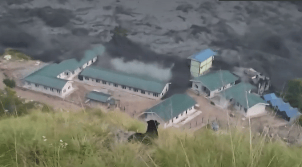
(Feature Image: Screengrab of BBC video report showing flood surge in Budhi Gandaki river damaging construction camp of 341 MW Budhigandaki HEP at Salleri in Gorkha district, Nepal in morning hours of Oct. 11, 2026)
The Budhi Gandaki river corridor in Nepal’s Gorkha district has witnessed a flash flood disaster causing extensive damage to public and private property. The flood reportedly began around 4:00 am on October 11, 2026, following the sudden breach of a landslide dam in a tributary of the Budhi Gandaki.
As per the reports, a massive dry landslide blocked the Ungilung stream, a tributary of the Syarkhola river, between Lokpa and Chumling in Chumnubri-6. The sudden breach released the impounded water into the Syarkhola, which overflowed its banks and in turn caused significant rise in Budhi Gandaki flood level.
The Syarkhola as a major left bank tributary joins Budhi Gandaki about 6km upstream Philim in Chumnubri Rural Municipality in Gorkha district. The deluge has destroyed scores of riverside settlements and river-based infrastructures including houses, bridges, drinking water lines in Lokpa, Jagat, Dobhan, Arughat and Benighat. At least four under construction hydro-electric projects (HEPs) have also been affected by the flood spell.
Preliminary official reports have confirmed that the devastating flood spell has occurred without any significant rainfall in the catchment area of Budhi Gandaki in the affected region. Based on available information and satellite imageries, the experts have attributed the deluge to a sudden breach in landslide dam in Unglilung stream.
Viral videos of the disaster show the Budhi Gandaki surging with huge volumes of dark sediment, debris and logs and even giant boulders possibly increasing the force and destructive power of the flood.
Flood Rise & Estimated Volume: According to the Flood Forecasting Division’s report, the information about a sudden rise in the Syarkhola’s water level near Tumje was received around 6:00 am on Oct. 11. Preliminary information indicated that a landslide had blocked the river, creating a temporary obstruction. The flood followed the sudden release of the impounded water. The report stated that further examination was needed to establish the precise cause and that the analysis was ongoing.
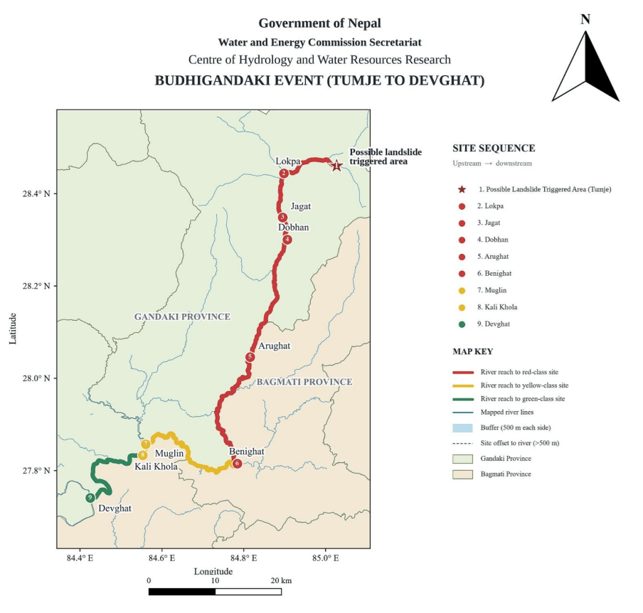
The report suggests the flood spell has affected the Gandaki corridor lying between Tumjhe to Benighat placing the flood levels were in Red class between Tumjhe to Benighat and in Yellow class upto Kali Khola in the river.
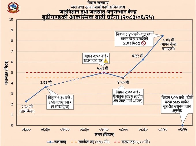
Sharing details of rise in flood level at the Arughat measurement site, the report shows a rise of about 6.16 meter (from 2.27 m to 8.43 m) between 6:00 am and 8:40 am on Oct. 11 at the site. The station along with the bridge on which it was establish were subsequently swept away disabling further readings at that location.
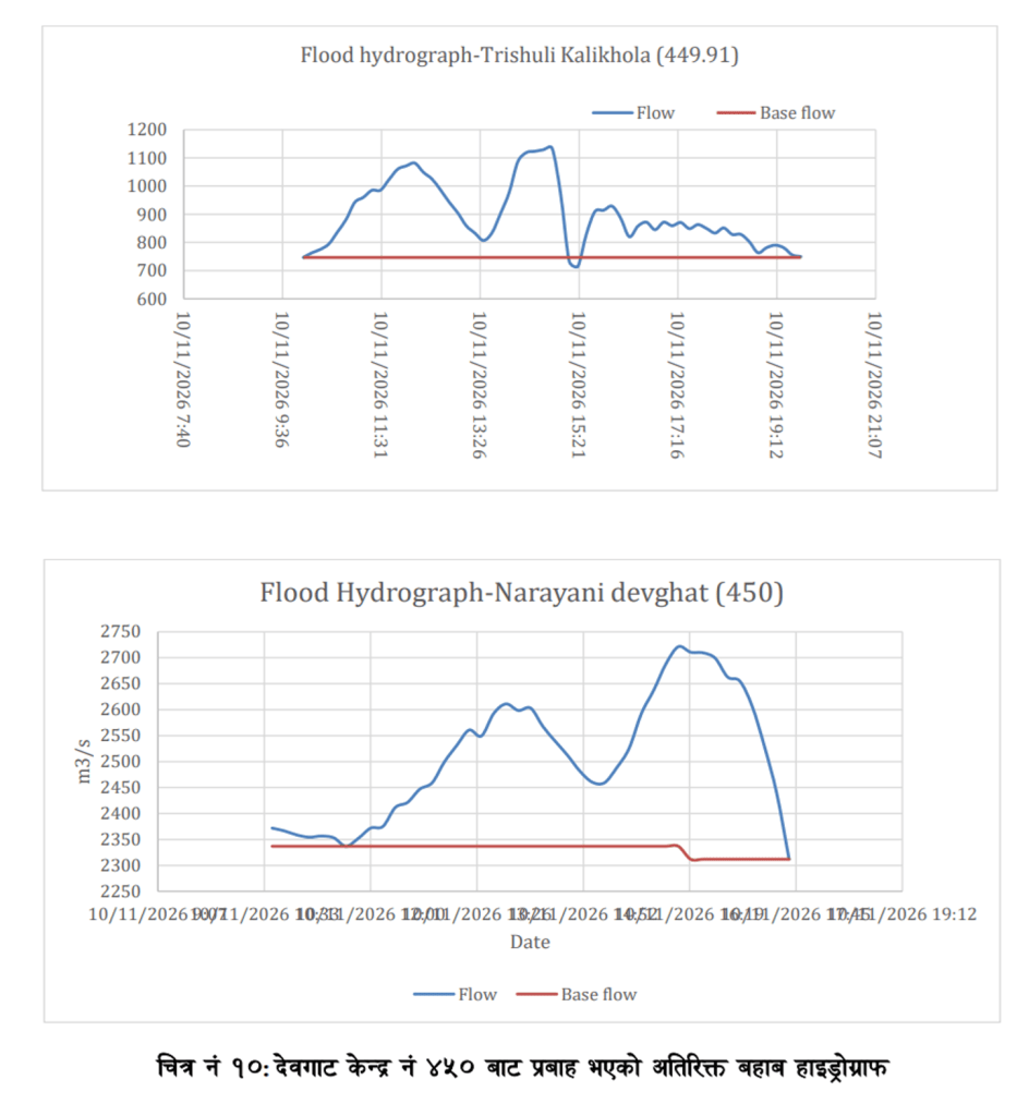
An analysis of hydrographs from the Kalikhola and Devghat hydrometric sites by the agency has estimated that the flood carried an additional water volume of approximately 5.29 million cubic metres past Kalikhola and 4.97 million cubic metres past Devghat. The report has described the deluge as substantial in magnitude. As per the report, the figures are estimates based on hydrograph analysis and not direct measurements of flood discharge.
Flood Impact: The Nepal’s National Disaster Risk Reduction and Management Authority (NDRRMA) Situation Report 1 based on information available upto 10:00 pm, Oct. 12, has mentioned that the flood spell had displaced at least 654 people in Ungilung, Chumchet and Ward 6 of Chumnubri Rural Municipality. As per the report, 5 people have remained missing after the disaster, about 95 people including 9 foreign nationals have been rescued by Nepal Army from the affected areas using four helicopters.
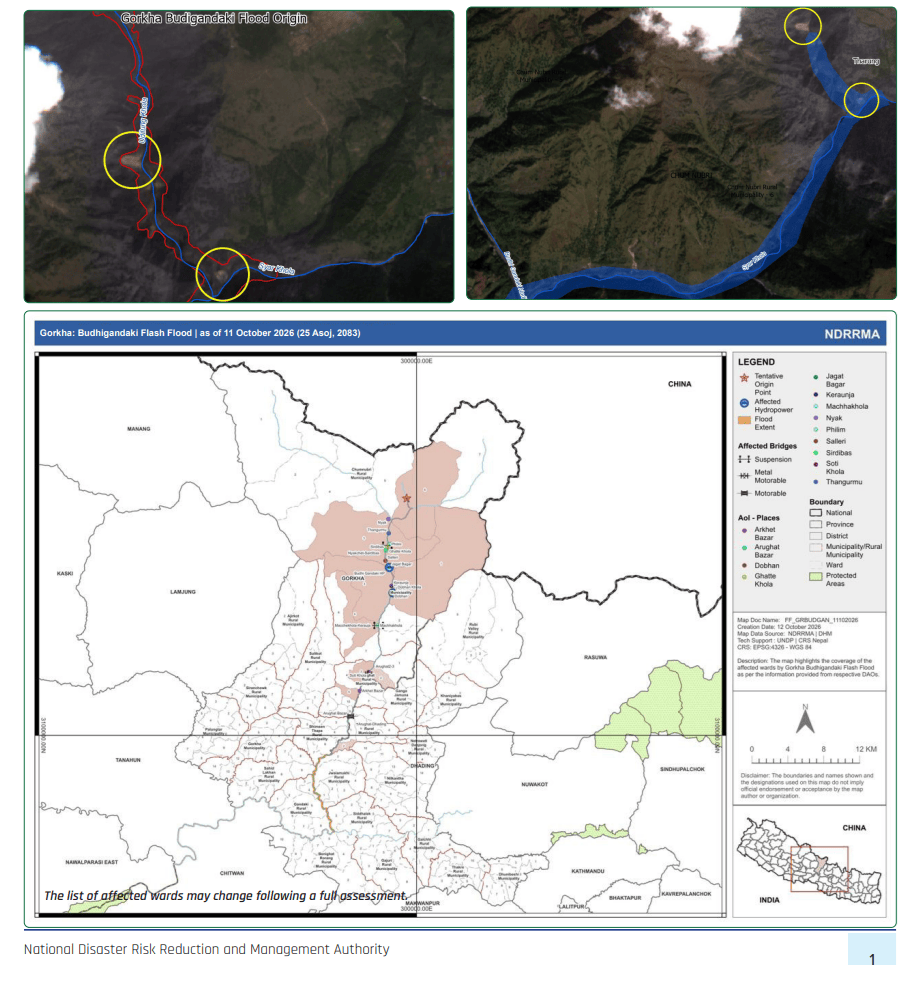
The deluge has severely damaged at least 204 houses, 10 drinking water supply schemes and a school building apart from sweeping away 05 bridges, 16 cattle sheds and 05 vehicles along the Budhi Gandaki corridor.
The collapse of bridges has disrupted road connectivity between Gorkha and Dhading and access between settlements along the river. The destruction has also affected Jagat Bazaar, an important access point for trekkers entering the Manaslu region. The full extent of the damage and the circumstances of the missing persons were still being assessed.
Impact on HEPs: The disaster has also affected four under construction HEP projects with a combined planned capacity of 412.09 MW. The damages included washing away of construction camps, equipment, materials and access bridges and roads.
The 341 MW Budhi Gandaki HEP has faced major damage as the deluge has washed away its main construction camp along with some construction equipment at Salleri in Chumnubri Rural Municipality-3. The project’s estimated construction cost is around Rs 70 billion. The company has not yet disclosed the total financial losses.
The 24.5 MW Dobhan Khola HEP has also suffered damage to its camp facilities and a Bailey bridge. At the 30.59 MW Yaru Khola HEP, a Bailey bridge has been damaged, while construction materials and equipment have reportedly been swept away. Similarly, the 16 MW Machha Khola HEP has sustained damage to its access road and the bridge connecting the project site.
Damage to access infrastructure could hamper the movement of workers, equipment and construction materials and delay construction. The full extent of the losses is yet to be known. The details of the affected HEPs can be seen in table below. (Source: Urja Khabar)
| SN | Project | Promoter | Damages |
| 1 | Budhigandaki (341 MW) | Times Energy Pvt. Ltd. | -Washed away main camp area -Swept few construction equipment |
| 2 | Dobhan Khola (24.5 MW) | Dobhan Khola Hydropower Ltd. | -Damaged few residents of camp area -Swept bailey bridge |
| 3 | Yaru Khola (30.49 MW) | Yaru Hydro-power Pvt. Ltd. | -Damaged bailey bridge -Swept few construction equipment |
| 4 | Machha Khola (16 MW) | Water Energy Development Pvt. Ltd. | -Damaged access road and bridge that connects the project site |
Impact on Micro HEP: The flood also disrupted electricity supply from the Sirdibas-Uhiya Micro HEP by washing away its 12 electricity poles, a transmission tower and transmission wires. The damage cut off power to 971 households in Chumnubri Rural Municipality. The project’s main powerhouse has remained intact.
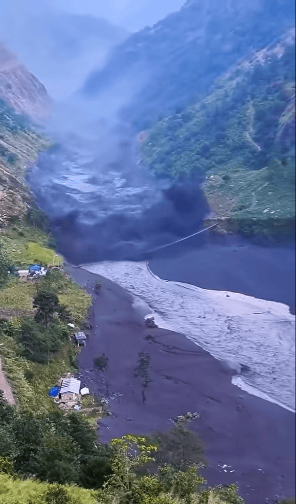
Past Flood Events: The same river valley has witnessed a catastrophic flood event in April 2024 after a huge ice avalanche from the snout of the Manaslu Glacier plunged into Birendra Tal. Together, these events clearly underline vulnerability Budhi Gandaki basin to geo-hydrological hazards.
Cascading Flood Event? Available information also suggests sharp fluctuations in river flood levels during this spell. There is possibility of more than one landslide blockages and subsequent breaches or some glacier related event in the upper river corridor intensifying the flood in scale and impact.
Examining satellite images from Oct. 1–11, 2026, Sudan Bikas, a GIS analyst at ICIMOD, noted the possibility of a rock avalanche originating from Shringi Himal, at approximately 6,500 metres above sea level most likely on Oct. 5. He shared his initial observations in a LinkedIn post on Oct. 12.
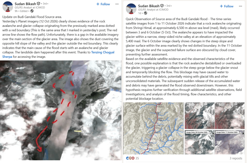
In a second post on Oct .13, Bikas reported that satellite imagery from Oct. 12 showed clear evidence of a rock avalanche and glacier collapse in the area. His observations suggest that the flood may have originated from the avalanche and glacier collapse. As per him, the landslide dam happened after this event.
This report also suggests that the flood may have involved a large slope failure, similar to the August 2026 Rasuwa disaster. A massive rock avalanche, possibly involving glacial ice, may have blocked the river temporarily with the subsequent breach releasing a destructive surge of water, sediment and debris downstream.
However, there is no official confirmation yet of whether the flood was triggered primarily by the breach of a landslide dam, the rock avalanche & glacier collapse or a combination of these events. Thus, the Oct. 2026 Budhi Gandaki flood spell may require further scientific investigation to establish the sequence of events and understand the causes and progression of the disaster.
Situation in India: The Budhi Gandaki flows south through Gorkha and joins the Trishuli river, which combines with other rivers to form the Narayani (Gandaki) river in Nepal. The Narayani enters West Champaran district of Bihar where it is known as the Gandak river. It joins the Ganga near Patna.
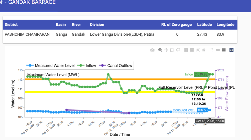
So far, the flood has not affected India. However, after gradual decline in inflows over past three days, the Gandak barrage hydrograph shows sudden rise in inflows from 1172.8 cumecs at 12:00 hour to 2019.83 cumces at 16:00 hour on Oct. 13, 2026. It seems the flood spell has taken about 54 hours to reach the barrage. The volume of inflows and operation of barrage will determine the flood impacts in coming days along the Gandak river.
SANDRP


