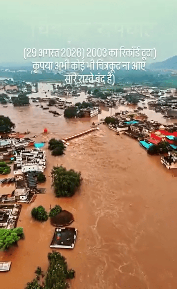
(Feature Image: Screengrab of drone video capturing severe flood spell in Mandakini river in Chitrakoot town, Satna on Aug. 29, 2026. Source: Hindustan Samachar)
The Mandakini (Paisuni) river has witnessed a major flood event in the pilgrimage town spread across Satna and Chitrakoot districts of Madhya Pradesh and Uttar Pradesh during August 28-30, 2026. The deluge was triggered after prolonged heavy rainfall in the upper hilly catchment of river, which broke records set 23 years ago. The flood spell has killed two people and left one missing in addition to causing widespread damage to public and private properties.
Impact in Chitrakoot: The flood severely inundated large stretches of Mandakini riverfront in Chitrakoot including ghats, temples, monasteries and other religious and pilgrimage facilities. Ramghat was among the worst-affected areas, with around 400 shops in and around the ghat flooded.
Floodwater also entered homes, hotels, dharamshalas and other buildings, forcing residents to move to rooftops or safer locations. Goods, household belongings, documents and other materials were damaged or buried under mud, silt and debris. Several vehicles parked along the ghats were swept away. The flooding caused extensive damage to homes, businesses, personal property and local livelihoods.
The situation was so critical that ten teams of NDRF, SDRF and PAC were deployed for relief and rescue operations while additional teams were summoned to strengthen the response.
Loss of Lives: The flood has caused death of two people while one elderly woman remains missing. Kamla Sharan, 65, from Sunaini in Arwal district, Bihar, was staying with around 50 pilgrims at Shivhare Dharamshala in the Nayagaon police-station area. When floodwater suddenly entered the dharamshala, three people were trapped. Two were rescued, but Kamla Sharan drowned.
The second victim, Sant Surdas, a priest at Ramdham Temple, drowned after floodwater suddenly entered his room as he tried to escape. In another incident, 95-year-old Patiniya Devi of Khatkana locality in Nayagaon was swept away and remains missing.
Impact on Transportation: The deluge swept away about 300-metre-long Ramghat–Hanuman Dhara bridge. The bridge was nearly 41 years old and its destruction disrupted an important local connection. The approach road to a bridge on the Karwi–Bedi Puliya route was damaged, while the Chitrakoot–Satna road became difficult to use.
Floodwater flowed over bridges, submerged several roads and low-lying routes restricting vehicular movement in the region for several hours. Rail connectivity was also badly affected as floodwater submerged parts of the Satna–Manikpur railway track, disrupting train operations. Around 44 trains were affected.
Impact on Power Infrastructure: The flood caused extensive damage to electricity infrastructure. Dozens of electricity poles reportedly fell between Ramghat and Sitapur with broken wires and transformers submerged. Several areas of the pilgrimage town remained without electricity for around 48 hours.
Impact in Rural Areas: The impact extended beyond the pilgrimage centre, affecting numerous villages and low-lying settlements in both districts along the swollen Mandakini and its tributaries. In Chitrakoot district, more than 400 people were evacuated from 16 affected villages. In Satna, Nagod, Birsinghpur, Majhgawan, Kothi and other low-lying areas faced severe flooding and waterlogging. On August 29, army helicopter was deployed to airlift people trapped in 12 villages in the district.
Prolonged Rainfall: The flood followed a prolonged spell of intense rainfall across the Mandakini catchment in Satna and Chitrakoot districts. India Meteorological Department (IMD) district-wise rainfall data show that both districts received large to large excess rainfall during the seven-day period from August 26 to September 1, 2026.
| Chitrakoot | Satna | |||||
| Date | Actual | Normal | Dep% | Actual | Normal | Dep% |
| 26.08.2026 | 19.3 | 10.2 | 89% | 12.5 | 7.2 | 73% |
| 27.08.2026 | 20.3 | 9.3 | 118% | 14.8 | 6.8 | 118% |
| 28.08.2026 | 23 | 4.9 | 369% | 6.6 | 5.7 | 13% |
| 29.08.2026 | 31 | 6.2 | 400% | 73.6 | 6.6 | 1015% |
| 30.08.2026 | 13.8 | 3.6 | 282% | 22 | 7 | 214% |
| 31.08.2026 | 47.8 | 5.7 | 738% | 23.8 | 5.9 | 304% |
| 01.08.2026 | 54.3 | 8.1 | 571% | 60.4 | 11.1 | 444% |
| 209.5 | 48 | 436% | 213.7 | 50.3 | 425% | |
Rainfall figure source: IMD
Cumulatively, Chitrakoot has received 1,049.5 mm of rainfall against the normal 637.2 mm, a 65% excess, while Satna has received 1,094.1 mm against the normal 766.7 mm, a 43% excess so far this monsoon season.
Record Flood Levels: The Mandakini surpassed its previous major flood level recorded in 2003 on Aug. 29, 2026. The Central Water Commission (CWC) operates three flood-monitoring stations on the river under its Lower Yamuna Division. This includes the Chitrakoot site in Satna district and Karwi and Sardhua in Chitrakoot district. While, the Karwi site is inactive since June 22, 2026 for unknown reasons, the river reached extreme flood conditions at the other two monitoring sites.
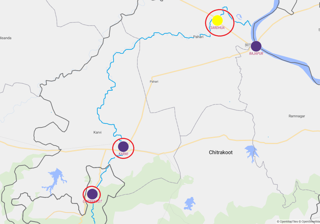
| Sites | WL/ DL | Old HFL/ Date | New HFL/ Date | Rise | Duration |
| Chitrakoot | 140.5m / 141.5 m | 142.65 m/ (2003) | 145.6 m/ 13:00 hr/ 29.08.2026 | 2.95 m | ~06 hrs |
| Karwi | NA | 139.93 m / 03.10.2019 | NA | NA | NA |
| Karwi (UP Irrigation Dept.) | 123.50 m/ 126.50 m | 134.50 m/ 2003 | 135.20 m/ 29.08.2026 | 0.70 m | NA |
| Sardhua | 88 m/ 89 m | 91.42 m/ 28.08.2022 | 91.50 m/ 15:00 hr/ 30.08.2026 | 0.08 m | ~08 hrs |
| 90.07/ 21.09.2019 |
Chitrakoot: The date of the previous HFL of 142.65 m at Chitrakoot is not known. According to Vasantha Kumar, Director, Flood Forecast, CWC, the exact date is unavailable because the monitoring site was shifted from Karwi to Chitrakoot in 2024. He further clarified that the 2003 HFL attributed to the Chitrakoot site was determined based on interactions with local residents, rather than from an available historical gauge record.
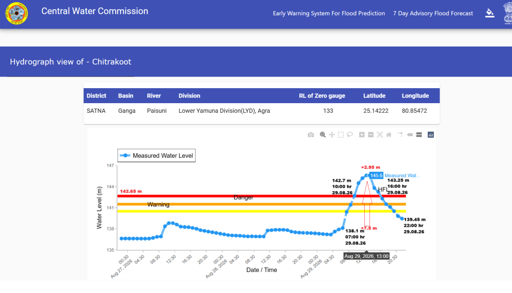
The new HFL of 145.60 m attained on August 29, 2026 at Chitrakoot site is 2.95 m higher than the previous HFL and about 5.1 m and 4.1 m above the warning and danger levels, respectively.
The flood level in the river increased sharply by 7.5 m in just six hours, from 138.10 m at 7 hrs to 145.60 m at 13 hrs on Aug 29, 2026. It then fell by 6.15 m over the next nine hours, reaching 139.45 m by 22:00 hrs same day. This rapid rise and fall points towards speedy runoff from intense rains in river catchment or sudden releases from some upstream storage projects.
Karwi: CWC established the Karwi monitoring site in 2019 and shifted it to Chitrakoot in 2024, leaving the site inactive during the peak monsoon season. However, readings from the UP Irrigation Department, cited in media reports, indicate that the Mandakini flood level at Karwi exceeded the 2003 HFL of 134.50 m (date unavailable) by 0.70 m, reaching a new HFL of 135.20 m on August 29, 2026.
There is a significant 5.43 m difference between the old HFL marked by the CWC 139.93 m dated 03.10.2019 and that recorded by the UP Irrigation Department (134.50 m in 2003).
Sardhua: The Mandakini had already set a new HFL of 93.00 m at Sardhua on Aug 3, 2025, surpassing the previous HFL of 91.42 m recorded on August 28, 2022. However, the CWC did not update its records to reflect the 2025 HFL and instead listed the 91.50 m peak recorded on August 30, 2026 as the new HFL.
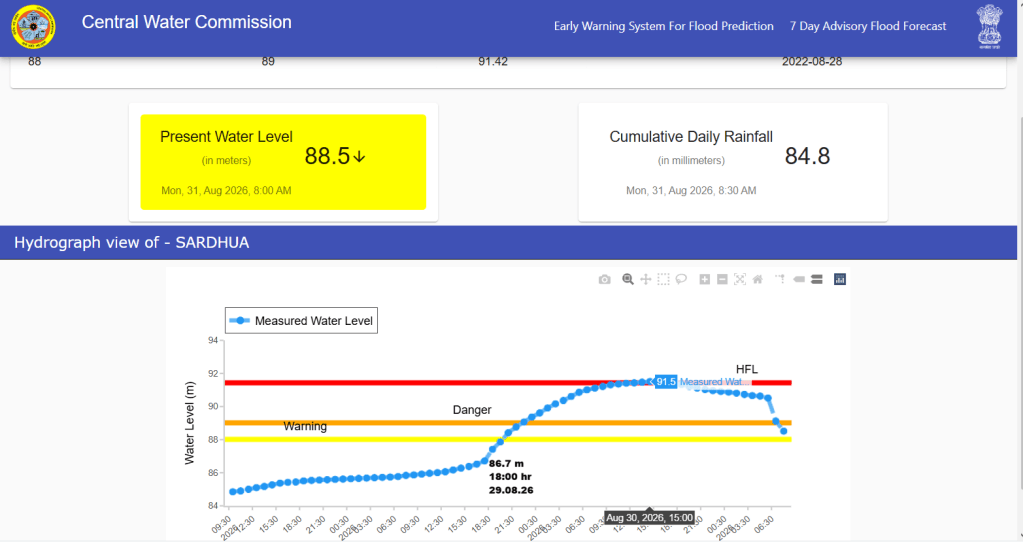
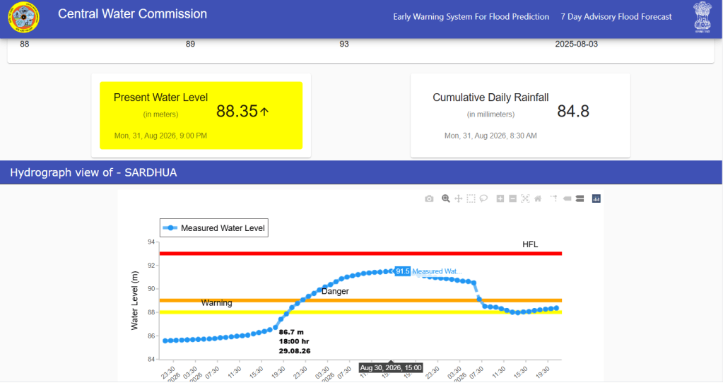
After SANDRP raised the matter, the CWC updated the 2025 HFL for the site. Overall, the available data indicates a significant increase in Mandakini flood levels at all the three monitoring sites, highlighting the severity of the August 2026 flood spell.
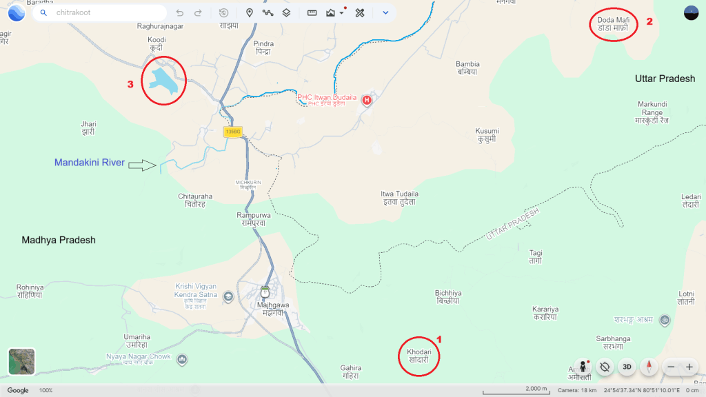
Breach in Dams? One of the most concerning and poorly documented aspects of the Mandakini flood is the reported breach of two small dams in the river’s upper catchment. Such breaches may have intensified downstream flooding but the available information is limited and requires verification.
Gorgi Dam located near Khodari village in Majhgawan tehsil of Satna reportedly beached on August 29, 2026, worsening flooding in surrounding low-lying areas and prompting emergency evacuations, relief operations. The breach has also been linked to the washing away of the Ramghat bridge. However there no official information regarding the breach and the extent of its contribution to the downstream flooding.
Doda Mafi Dam in Manikpur tehsil of Chitrakoot district reportedly came close to failure after one of its two gates became jammed and the dam began to overflow. Erosion and leakage alongside the gate further raised concerns about its structural safety.
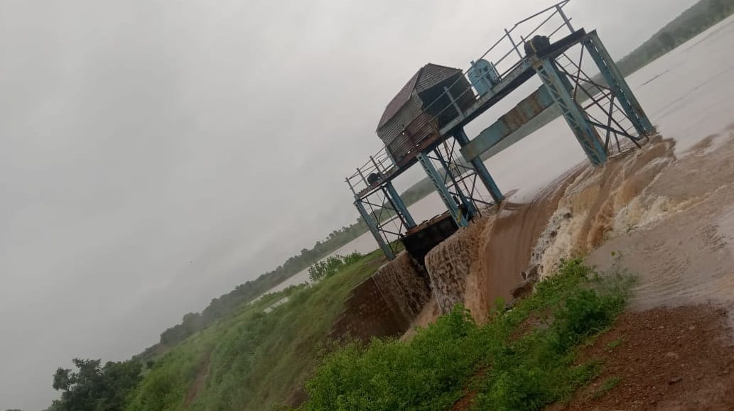
The villages of Doda, Cheriha, Jaromafi and Kalyanpur were severely affected by overtopping of dam. In Cheriha village, floodwater entered the settlement and around half a dozen houses collapsed, leaving several families without shelter. Residents of Kalyanpur said that 2–3 feet of water entered their homes, damaging stored rations, grain, clothes and household belongings.
Locals had reportedly complained about faults in both gates around 15 days earlier, but only one gate was repaired by the Irrigation Department. The situation caused panic among villagers who reportedly left their homes and moved to safer locations as a precaution.
The only official statement on the dam’s status was made public on Sept 2 by the District Magistrate, Chitrakoot when he posted some information and a video about it on X handle. As per the text the Executive Engineer, Irrigation Division-I, Karwi had informed about heavy rainfall in Satna on August 27–28 generated an inflow of about 6,500 cusecs into the dam. As the reservoir level rose, both spillway gates were opened on August 29 to release excess water and maintain dam safety.
The DM further stated that the reservoir level was below the Full Reservoir Level (FRL) and the dam was safe. Both gates were open and being monitored by Irrigation Department officials. He also reported that repair work on the damaged section was underway and directed that it be completed on priority to restore water storage for agriculture and other needs.
However, there is no reliable official information on the storage capacity of both dams, the exact extent of the breach or damage, or the timing and volume of water released. In the absence of these details, it is not possible to quantify the contribution of the reported dam breaches or releases to the severity of the Mandakini flood.
Moreover, the location of these dams is difficult to trace on Google Earth, making it challenging to establish their exact drainage and connectivity with the Mandakini River. The only dam of notable size identified in the area is the Pindra Dam on the Pindra river, near Koodi village in Majhgawan block of Satna district. Releases from the dam reportedly inundated nearby houses and roads. However, there is no conclusive information on the volume or timing of releases or their contribution to the Mandakini flood.
Renewed Flood Threat: The flood emergency did not end with the first spell. The Mandakini began rising again on the morning of August 31, sending water back towards shops and other low-lying areas around Ramghat. Following overnight rainfall in Satna and Chitrakoot, the river level rose again on September 1, inundating Ramghat and submerging shops, houses, ashrams and hotels along the riverfront.
Roads connecting Ramghat with Kamta Nath, Arogyadham and Janki Kund were also flooded. With more rainfall forecast, the Satna district administration issued a seven-day flood alert and ordered the closure of educational institutions until September 1 which was then extended until September 03.
CM Seeks Report: MP Chief Minister Mohan Yadav visited Chitrakoot on August 30 and described the next two to three days as critical. He directed senior officials to camp in the area and closely monitor the situation. He also sought a detailed report on whether encroachments, construction and other human interventions had worsened the flooding. So far, there is no information on any similar assessment being ordered or done in UP side of Chitrakoot.
About Mandakini: The river is about 130 km long and has a catchment area of around 1,956 sq km. It originates in the Khillora hills near Pindra village in Majhgawan block of Satna district, MP flows through Chitrakoot and joins the Yamuna near Rajapur, UP. Known as Paisuni in survey maps and official records, the river is central to Chitrakoot’s religious and ecological landscape and key source of numerous livelihoods associated with pilgrimage and tourism.
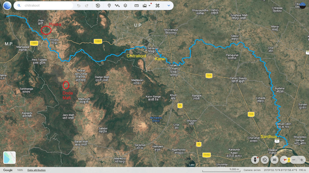
About 59 km of the river lies in Satna district, while the remaining 71 km flows through Chitrakoot district. The river is largely seasonal along its first 39 km, with most of its flow occurring during the monsoon. It becomes perennial around Sati Anusuiya, where numerous springs contribute to and sustain its flow.
There are over a dozen seasonal streams and drains including Jhuri, Semrawal, Mau, Amravati, Kali Barah, Sharbhanga, Valmiki, Gedua, Ohan and Piprawal join the Mandakini along its course and influence its flow and flood response.
Pollution: The river is a lifeline for Chitrakoot and the surrounding areas, with nearly 70% of residents reportedly dependent on its waters for drinking and household needs. However, years of untreated sewage discharge and solid-waste dumping have severely degraded its water quality and ecosystem.
In 2020, the river was identified as one of the most polluted rivers in Madhya Pradesh. To revive the river with Narmada water through Bargi canal, CM Shivraj Singh Chouhan had announced a ₹244-crore dam on the Payaswini (Paisuni) river at Pindra in Aprill 2022.
Encroachment and concretisation are also major threats to the river particularly around Chitrakoot. Hotels, temples and other structures have come up close to the riverbank, while construction has reportedly blocked springs and reduced natural recharge. The encroachment and concretisation of the riverbank and flood zone may also have reduced the river’s natural flood carrying and absorption capacity, potentially worsening the impact of floods in the area.
Despite NGT 2014 & 2021 directions to restrict construction in 100 meters of riverbank and demarcate the river area, illegal construction remains unchecked. Therefore, protecting recharge zone, removing encroachments and preventing further concretisation are imperative steps to restore the Mandakini’s flow and ecological health.
Summary: The devastating August 2026 flood along the Mandakini in the Satna–Chitrakoot region appears to have been primarily driven by extreme rainfall. The reported breaches at Gorgi and Doda Mafi dams may have aggravated flooding locally, but credible information on is needed to establish their actual contribution to the record Mandakini flood.
However, the deluge raises serious concerns about riverbank construction, encroachment, loss of floodplain areas and obstruction of natural drainage. Thus, the record flood provides a strong basis for a comprehensive catchment-to-floodplain assessment of the Mandakini in Chitrakoot region. This should include restoring natural drainage and floodplain spaces and strictly regulating further construction and encroachment along Mandakini and its tributaries.
SANDRP


