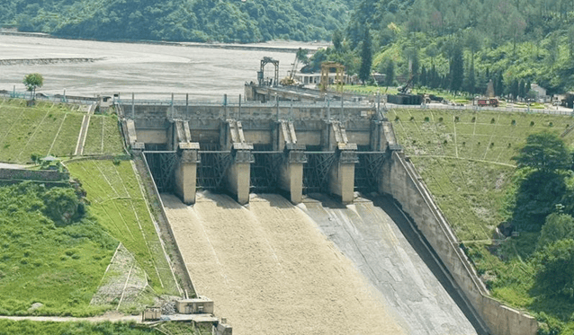
(Feature Image: The Tribune’s file photo of Pandoh dam)
The Central Electricity Authority has said in its report that there have been some serious operational and maintenance issues at BBMB’s Pandoh project, part of Beas Sutlej Link Project. In a separate development, Punjab government affidavit in the NGT has said that due to mismanagement at Bhakra-Pong dams, there has been avoidable flood disasters in Punjab in several years. Both developments confirm what we have said about role of BBMB projects in 2023 and 2025 floods in Punjab.
The CEA report also mentions mismanagement of dredging operations, leading to loss in generation at the Dehar Power Station of the Pandoh Dam, as alleged by the Punjab government earlier. This also has serious implications for the safety of the project. The report unfortunately does not seem to go into the reasons for faster siltation of the Beas Sutlej Link project. The dumping of muck into the river by various hydropower, highways and other infrastructure projects has majorly contributed to this. An independent assessment would help bring all such factors to light.
The Punjab government affidavit in a case being heard by the National Green Tribunal regarding mismanagement of BBMB dams during floods also mentions the flaws in the rule curves of the Bhakra and Pong dams as proposed by Central Water Commission. The CWC proposals also ignored low lying areas of Punjab and downstream river carrying capacity. All this again needs an independent assessment as we have been underlining the poor performance of CWC in flood forecasting and flood management by dams. One hopes NGT will indeed go into depth of these issues and order an independent assessment, though the NGT’s orders so far this year seems to suggest that this hope may be misplaced.
CEA: Lapses in BBMB’s Pandoh Power House The CEA has flagged serious operational & maintenance issues at the Bhakra Beas Management Board’s (BBMB) Beas Sutlej Link (BSL) Project & Dehar power house in Himachal’s Mandi district. The report has flagged declining generation, heavy silt accumulation, inadequate desilting & ageing machinery.
The report was prepared by member, CEA, after a visit to the BSL project from March 26 to 27, 2026. It says that the 990-MW Dehar power house has been facing persistent difficulties, with silt identified as a major factor affecting the performance of the generating units. The report also examined allegations made by Punjab regarding operational lapses, including alleged violation of a Technical Committee decision, improper removal of silt and poor maintenance of power house equipment. The report says correspondence on these issues had been exchanged between Punjab’s Water Resources Department and BBMB.
A calculation based on market replacement power prices put the loss at Rs 129.88 cr, while another calculation based on the BBMB tariff reduced it to Rs 31.75 cr. The report states that attributing the entire claimed loss of around Rs 460 cr to alleged BBMB mismanagement would be inappropriate, as the generating units are old and face operational difficulties, particularly when silt-related problems arise.
The report said there had been a quantum jump in silt accumulation in the Sundernagar Balancing Reservoir after the 2023 monsoon. Although dredging was being undertaken, it found the efforts were not sufficiently organised, focused or target driven.
The CEA report said that the first Dehar unit was commissioned in November 1977 and the last in November 1983. The electro mechanical machinery had crossed its original design life, and the units had effectively completed their life cycle in 2018 under applicable regulations. For the longer term, the report recommends a detailed renovation and modernisation proposal covering all components of the project.
The report recommends focused attention to the safety and operation of Pandoh Dam and continued efforts to check the inflow of high silt into the reservoir. Questions were raised regarding privatisation of desilting process of balancing reservoir of the project that allegedly led to major damage of turbines at Dehra project and loss of generation. Punjab water resources department had pegged loss of generation from project at Rs 460 crore.
Punjab Govt flags lapses in Bhakra Pong dam operations The Punjab government has flagged multiple gaps in the operations of the Bhakra Beas Management Board (BBMB), which manages the Bhakra and Pong dams, and called for a flexible and technology-driven approach to deal with changing monsoon patterns and sudden high inflows. The state government flagged these points in an affidavit filed recently before the NGT, which is hearing a petition alleging mismanagement of the twin dams.
The Punjab government said the state suffered severe flood damage in 1988, 2019 and again during 2023 and 2025, when water levels reached near 1,680 feet at the Bhakra dam and crossed 1,390 feet at the Pong dam. It added that the Sutlej and Beas carry massive floodwater, which affects the state’s livelihood. The Bhakra dam is built on the Sutlej and the Pong dam on the Beas.
“It is further submitted that the state of Punjab had raised some observations in the new rule curve submitted by the Central Water Commission (CWC) as it had some flaws and the rule curves have not yet been formally approved by the BBMB.” The CWC has proposed enhancing the FRL of the Pong dam to 1,400 feet, which the Punjab government objected to, citing that the proposal ignored the state’s various low-lying districts. The proposal is pending before the BBMB.
“Moreover, the downstream carrying capacity of the rivers was not considered while preparing these rule curves; hence, these rule curves need to be revised,” the Punjab government said. Following the 1988 floods, the BBMB had decided to maintain maximum storage levels of 1,680 feet at Bhakra and 1,390 feet at Pong. The inflows received at the Pong and Bhakra dams were higher in 2023 and 2025 compared to 1998, the state govt said.
The state also called for “advanced technological tools for inflow prediction, real-time reservoir monitoring, and scientific planning of reservoir operations, so as to enable timely, informed, and proactive decision-making, particularly during flood situations”.
HYDRO POWER PROJECTS
SUMP: Villagers stage protests against PFR activities Villagers from Komkar and villages in and around Uggeng staged protests at two separate locations across Upper Siang and Siang districts on Sept. 14, opposing the proposed conduct of pre-feasibility report (PFR) activities in Uggeng, one of the proposed dam sites of the Siang Upper Multipurpose Project (SUMP). The government is expected to begin the PFR activities in October, following the signing of an MoU for the PFR earlier. The villagers maintained that their concerns should be addressed and clarity provided regarding the MoU, the proposed project, and the planned PFR and drilling activities before such activities are taken forward.
ABK-U opposes PFR survey Expressing serious concern over the alleged forcible conduct of pre-feasibility survey by the National Hydropower Power Corporation (NHPC) and deployment of paramilitary forces at Komkar, ABK-U president Thomas Borang urged CM Pema Khandu to stop drilling and other machinery activities at the proposed project site. On Sept. 14, the govt deployed a huge contingent of paramilitary forces at Ugeng village in Upper Siang, but the security forces faced protest from the villages of the project-affected area. The local villagers are rigid on their stand that they are opposing any mega dam project which would destroy their fertile land and other resources.
Activist booked by CBI The Central Bureau of Investigation has filed a case against Arunachal Pradesh-based lawyer and environmental activist Bhanu Tatak for allegedly receiving funds from abroad during 2022-‘25 in violation of the Foreign Contribution Regulation Act. Tatak is a legal adviser to the Siang Indigenous Farmers’ Forum and the coordinator of Dibang Resistance group.
The state’s refusal to acknowledge the people who are fighting to save their land, and to take their fear and apprehension into account, continues while the state weaves a narrative in the name of countering a powerful neighbour’s attempt to control the river, flood control, strategic interests, and national security.
One fails to understand how the government talks about the security of the nation while uprooting the people living there. Displacement of an entire community in the name of national security is logic-defying, but it’s a tactic used by oppressive govts each time, where the rights of indigenous communities are too often sacrificed in the interest of the nation and its security. (Tongam Rina)
CLIMATE CRISIS
Sikkim HC initiates PIL on ‘climate justice’ The High Court of Sikkim has initiated a suo motu public interest litigation (PIL) after taking note of the “severe hardship and impact” caused by the recent flash floods in neighbouring Nepal. An order in this regard was issued on Sept. 17 by a division bench of Chief Justice A Muhamed Mustaque and Justice Bhaskar Raj Pradhan. The court appointed three lawyers as amici curiae in the matter. Next hearing on October 6.
The Court further widened the scope of the case by impleading four additional respondents: the Sikkim State Disaster Management Authority, the Power Department of the Government of Sikkim, the Ministry of Railways and the National Highways & Infrastructure Development Corporation Limited (NHIDCL). Notice was issued to all impleaded parties. The SSLSA has additionally been tasked with assisting the Amici Curiae in gathering local inputs and information from various regions of the state, while the Registry has been directed to carry out all necessary procedural compliance.
Nearly 200 Scientists sign an urgent Call to Action for the upcoming Super El Niño The 2026/27 El Niño is predicted to be the most extreme such event in 100 years. It is likely to bring exceptional climatic conditions to marine, freshwater, and terrestrial ecosystems in India. There is an urgent need to document and understand the effects of such an event on the natural world and connected social systems. Recognising this, a group of close to 200 ecological researchers and practitioners have put out a call to fellow ecologists in India to respond by strengthening and expanding our research and monitoring efforts in order to better understand the effects of extreme climate events.
El Niño & global heating pushes water vapour in atmosphere to record levels in Aug The planet’s atmosphere held more water vapour in August than any other month on record, further increasing the risk of extreme heat and rainfall around the world, according to Europe’s climate change service. Climate scientists said global heating was a contributor to the record because a warmer atmosphere can hold more water, and the historic El Niño in the Pacific Ocean was also likely pushing water vapour levels up.
According to the Copernicus Climate Change Service (C3S), the amount of water vapour in the atmosphere through August was 27.35 kg per square metre, beating the previous record from July 2024 by 0.04 kg m². The value describes how much water vapour is in a column of air sitting above a square metre of the Earth’s surface, extending up through the atmosphere. The 0.04 kg m² increase on the previous record, one climate scientist calculated, was the equivalent of about 20 trillion litres of additional water, or 20 cubes of water, each a kilometre wide, high and deep.
23 Uttarakhand glaciers melting rapidly: Study Twenty-three major glaciers in Uttarakhand are melting rapidly, with rising temperatures and the geographical characteristics of individual glaciers contributing to their retreat, according to a study by scientists at the Wadia Institute of Himalayan Geology.
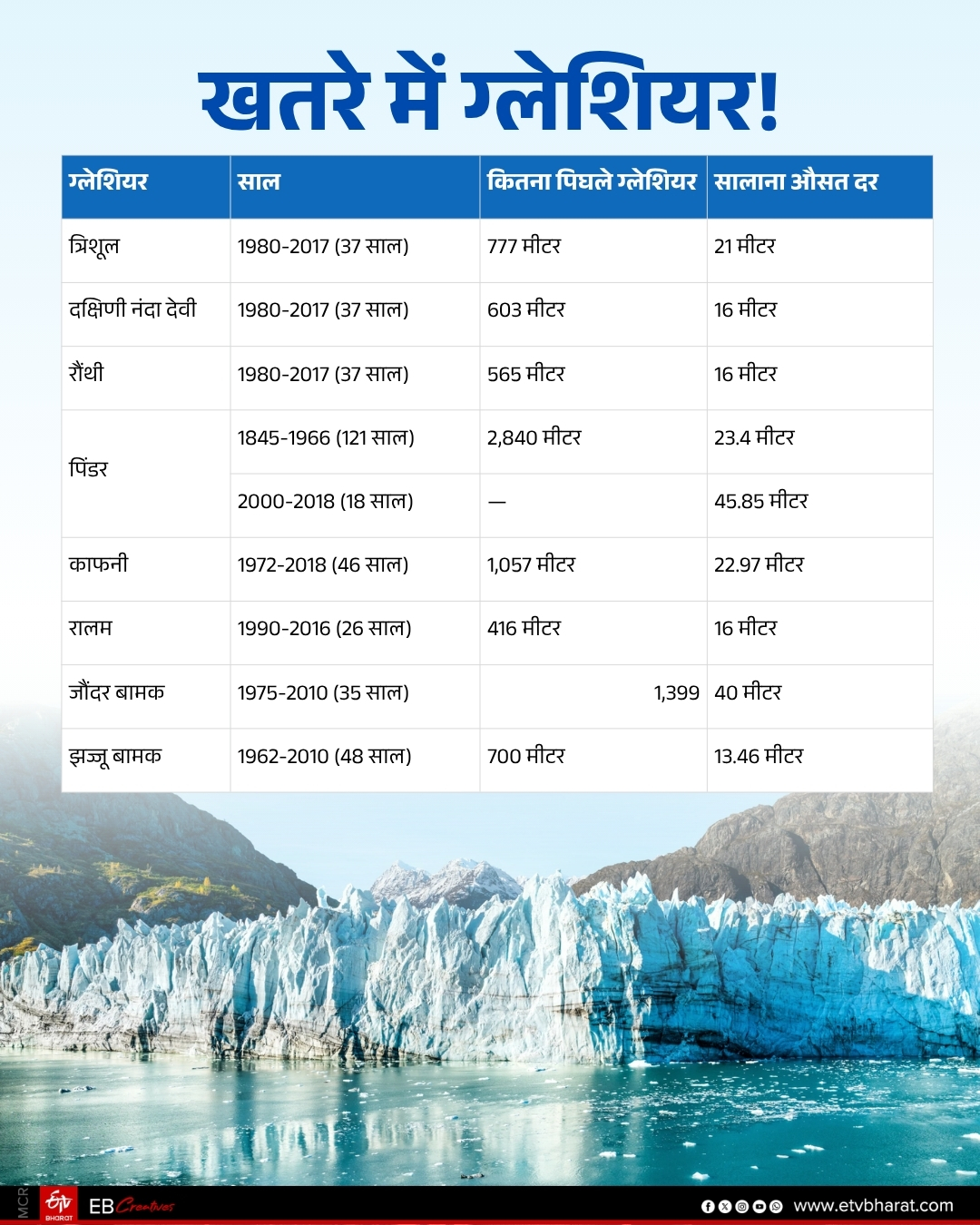
The historical records of all these glaciers were studied, and it was found that debris-covered glaciers are melting at a few metres a year, while clean-ice glaciers are melting much faster. If glaciers continue to melt at this rate, there is a risk of rising sea levels eventually. The risk of natural disasters, such as glacial lake outburst floods (GLOFs), avalanches and debris flowing down from higher altitudes, has also increased.

The rate of glacier melt has risen sharply since 2000. One reason for the melting is rainfall at altitudes of up to 4,000 m, where snow used to fall but now it rains. The summer season has also lengthened, winter snowfall has declined sharply, and the snow that does fall does not get time to consolidate.
The study, “Time-dependent assessment of glacier recession in the Indian Central Himalaya”, which is based on observations and satellite imagery from 1990 to 2024, also found that the equilibrium line altitude has risen by nearly 500 metres in some regions since 2000.The researchers said the findings have major implications for regional hydrology, natural hazard management and long-term water security. The Ganga basin supports around 800 million people, making changes in the Himalayan region particularly significant for downstream populations.
Himalayan glaciers losing mass 65% faster than they did in the previous decade, increasing risks to water supplies and mountain communities, according to a new report. The report, Prosperous and Resilient Himalayas, says retreating glaciers are leaving behind unstable lakes, while melting permafrost and unstable mountain slopes are increasing the risk of cascading disasters.
7 high-risk glacial lakes identified in Tawang: APSDMA Arunachal Pradesh State Disaster Management Authority (APSDMA) Deputy Director Dorjee Khandu informed that seven high-risk glacial lakes have been identified in the Mago area in Tawang district, of which six share a common downstream drainage system passing through several villages, including Duri.
Khandu informed this during the launch of an awareness campaign on glacial lake outburst flood (GLOF) risks which commenced at Mago village, with special focus on vulnerable downstream habitations, including Duri village, as well as the Indian Army camp situated in the area.
The SDMA DD stressed the need to establish locally suitable and effective early-warning mechanisms, so that alerts can reach every resident on time. He also emphasised on prompt dissemination of warnings to downstream settlements in the event of a GLOF, particularly as Duri village would be among the first settlements likely to experience the impact of floodwaters.
DAM SAFETY
NDSA Reviews Dam Safety Preparedness in Jharkhand NDSA emphasised the need for expeditious constitution of the Independent Panel of Experts (IPoE), timely completion of dam visits and submission of CDSE reports to the Authority. The State was also requested to prepare and furnish a dam-wise action plan for completion of CDSE within the prescribed timeline.
The meeting also reviewed the status of Emergency Action Plans (EAPs) and Operation & Maintenance (O&M) Manuals. Instructions were issued for their timely preparation and subsequent uploading on the DHARMA Portal. The inspection status of Category-II dams was also reviewed and a time bound action plan for rehabilitation of such dams was sought.
NDSA emphasised strengthening of the State’s institutional framework for dam safety, including reconstitution of the SDSO as a dedicated organisation rather than a committee-based arrangement. The need for operationalisation of a separate budget head for dam safety and appropriate allocation and utilisation of funds was also emphasised.
The dam owner of Nalkari Dam (Patratu), under the Energy Department, was specifically directed to constitute a Dam Safety Unit (DSU) and undertake pre-monsoon and post-monsoon inspections in accordance with the applicable dam safety regulations.
As part of the field level review, the NDSA team visited Nalkari Dam on Sept. 8, 2026 and Latratu Dam, a Category-II dam under the Water Resources Department. Necessary instructions were issued to the concerned dam in-charges for rectification of deficiencies observed during the visits.
TN awaits WAPCOS report on desilting dams The Tamil Nadu government is keen to desilt major reservoirs, including Mettur, Vaigai, Amaravathi and Pechiparai, once the Water and Power Consultancy Services Limited (Wapcos) submits its feasibility report on the same. The DMK government in 2024 entrusted Wapcos with obtaining statutory approvals from various agencies, including clearance from the Union Ministry of Environment, Forest and Climate Change, preparing a DPR, and conducting a feasibility study.
According to Water Resources Department (WRD) officials, Wapcos is expected to submit the report by December. Officials said several advanced technologies, including underwater robotic crawlers and modern dredgers, could enable desilting in active reservoirs without disrupting water flow. However, funding and finding space to store dredged material remain major hurdles. “When desilting is taken up in major reservoirs, a massive area is required to store different types of dredged material,” a senior WRD official said.
According to a Central Water Commission (CWC) assessment, the Mettur reservoir has lost nearly 18 tmcft of its capacity due to sedimentation since it was commissioned in 1934.
Umiam dam to undergo fresh seismic study; MePGCL floats tender The Meghalaya Power Generation Corporation Limited (MePGCL) has floated a tender for a fresh site-specific seismic study of the Umiam Stage-I dam, one of the state’s oldest and most important hydropower projects. The latest tender does not state that the dam has developed a safety problem. Instead, it calls for a site-specific seismic investigation, which will provide technical information about the ground and site conditions needed for assessing the structure in relation to earthquake forces.
MePGCL will need to clarify when the previous comprehensive seismic assessment of Umiam Stage-I was carried out, whether the latest investigation is part of a routine dam-safety exercise and whether any strengthening or rehabilitation work could follow its findings. The outcome of the assessment will indicate whether any additional technical or structural measures are required to ensure the continued safe operation of the ageing project.
DAMS
6 states signed Kishau Multipurpose Project agreement Union Home Minister Shri Amit Shah said that first, in August 2018, the dispute over the Lakhwar Multipurpose Project was resolved. In 2019, the dispute over the Renukaji Multipurpose Dam Project in the Upper Yamuna Basin was resolved. In 2021, Madhya Pradesh and Uttar Pradesh reached an agreement on the Ken-Betwa Link Project, benefiting the water-stressed region of Bundelkhand. The revised Parbati-Kalisindh-Chambal River Link project moved forward in 2024. The scheme for transferring water from Hathinikund to the Yamuna through an underground pipeline was approved in February 2024.
Union Home Minister Shri Amit Shah said that with regard to the Kishau Multipurpose Project, an agreement was reached on 12 May 1994 that separate agreements would be entered into for each storage project coming up in the basin. Without that arrangement, this would not have been possible. Subsequently, after the disputes concerning the Lakhwar and Renukaji projects were resolved in 2019, work on Kishau moved forward. Formal agreement on the project was reached on 16 June this year.
Union Home Minister said that when the waters of the Yamuna were allocated, there was a serious lapse on the part of policymakers. The environmental flow of the Yamuna was not calculated at all and all the available water was distributed among the states. No water was left for the river itself. He said that 25 per cent of the water will become available through the Kishau Multipurpose Project Agreement, which will prove extremely beneficial for both Delhi and the Yamuna. It will also contribute to environmental conservation.
The Kishau Dam was one of three storage projects planned in the upper reaches of the Yamuna and its tributaries following a MoU signed on May 12, 1994 by the Yamuna basin regarding the allocation of Yamuna water. The other two projects were Lakhwar and Renukaji, for which the MoUs have already been signed and are under implementation. As per the 1994 MoU, an interim seasonal allocation of the annual utilisable flow of river Yamuna was made among these five states.
Of the total 11.983 billion cubic metres (BCM) of annual utilisable water of the Yamuna, a maximum allocation of 5.730 BCM was made to Haryana, followed by 4.032 BCM to Uttar Pradesh, 1.119 to Rajasthan, 0.724 BCM to Delhi and 0.378 BCM to Himachal Pradesh. When Uttarakhand was created in 2000, the 4.032 BCM share of water of undivided Uttar Pradesh was allocated to UP and Uttarakhand as 3.721 BCM and 0.311 BCM respectively. Earlier this year, a DPR of the Kishau project was circulated among the states concerned but it is yet to be finalised.
The Yamuna will receive additional freshwater under the Kishau project, with Delhi and Rajasthan agreeing to fund the project’s power component in return for a share of the water, Union jal shakti minister CR Patil said on Sept. 16. Patil said Delhi and Rajasthan had offered to make the capital investment required for the power component in exchange for a share of the water. “Delhi’s chief minister and Rajasthan’s chief minister said that we will make the capital investment for the power project, but we will take the water. So 75% of the water will come into the Yamuna. 25% will go to Rajasthan,” he said.
The Home Minister expressed confidence that we will be able to achieve the goal of a clean Yamuna by 2029. CM Nayab Singh Saini said Haryana’s share in Yamuna’s water was 48 per cent and so the state will directly benefit from the increased water from the project.
Experts raise concerns Himanshu Thakkar, a water expert with the SANDRP said the Himalayan region was unstable and highly seismic. “This multipurpose project is actually dangerous because the entire Himalayan region falls in an unstable and highly seismic zone”.
He said the project could increase risks already emerging from climate change. Thakkar also called the government’s claims on Yamuna cleaning and water supply misleading. “The claim that this dam will clean the Yamuna River is misleading. A separate, dedicated programme is needed for cleaning and rejuvenating the Yamuna, not simply trying to dilute the pollution by blocking the river’s water,” he said. He argued that the concerned states should focus more on rainwater harvesting to meet their water needs.
Mansi Ashar, a researcher with Himdhara Environmental Research and Action Collective, said a 2014 field study indicated that the impact of the Kishau dam would not be limited to the submergence area. She said the project would affect agriculture, animal husbandry, forests, fisheries and local livelihoods in the Tons River valley. Ginger and tomato cultivation, in particular, would be badly affected, she said.
Kishau agreement sparks protest in Uttarakhand villages Fear of losing their ancestral homes and land brought residents of Kwanu and neighbouring villages in Uttarakhand onto the streets on Wednesday, a day after the Centre and six Yamuna basin states signed an agreement to move ahead with the long-pending Kishau Multipurpose Project. The Kishau Bandh Sangharsh Samiti staged a protest at Kwanu in the Jaunsar-Bawar region of Uttarakhand in the presence of local MLA Pritam Singh Chauhan. Protesters burned effigies of the Central Government and the state government and raised slogans against the proposed dam.
For families living in the project-affected area, the Kishau project is not simply about a dam or water and power generation. It is about the possibility of being uprooted from land where their families have lived for generations. “Why are people living in the hills being displaced to meet the water and electricity requirements of the plains?” residents asked during the protest, questioning why communities settled in the mountains should have to sacrifice their homes and land for the benefit of areas downstream.
Kishau Bandh Sangharsh Samiti patron Munna Singh Rana, president Surya Pratap Singh and vice-president Narendra Singh Rana said the people of the affected area shared an ancestral and emotional bond with the mountains. The Samiti leaders said compensation could not fully address the loss of ancestral land, homes and the traditional way of life of the affected families. “We may accept death, but we will not leave our soil,” they said, asserting that the affected communities would continue to oppose displacement.
INTERLINKING OF RIVERS
Chenab-Beas link project triggers disaster alarms The National Hydroelectric Power Corporation (NHPC) project entails constructing a 19-metre concrete barrage near Koksar on Chandra river at an altitude of around 3,140 metres. An 8.7-km tunnel through the Pir Panjal range would divert water into the upper Beas basin around Dhundi, Palchan or Solang near Manali to boost downstream power generation by up to 4,000 MW. Environmentalists argue the project threatens both basins, which are increasingly vulnerable to glacial lake outburst floods (GLOFs), flash floods, avalanches and landslides following recent climate-linked disasters in the Himalayas.
“It’s the worst possible site for building a barrage and a tunnel,” said environmentalist Himanshu Thakkar, of SANDRP. Koksar sits in the headwaters of Chandra river and has expanding glacial lakes, including Samudra Tapu and Ghepan lake that pose a GLOF threat and a number of glaciers, including Bara Shigri glacier, the largest in Himachal. The number of glacial lakes in Chandra basin rose from 23 to 73 between 2016 and 2022. And in Chenab basin, the lakes rose from 133 to 399 during the same period, a 200% increase. Environmentalists argue that building a barrage, along with the blasting, tunnelling and muck disposal the project requires, will require permanent infrastructure on an already ecologically fragile terrain.
The proposed discharge zone — around Dhundi, Palchan or Solang in the upper Beas basin — is itself a disaster-prone corridor repeatedly hit by flash floods, landslides and avalanches. The 2024 cloudburst and flash floods damaged Palchan bridge and severed Leh-Manali highway, while the 2025 monsoon caused further damage and kept access to Atal Tunnel disrupted.
Brigadier Khushal Thakur (retd), a Kargil war veteran, said Beas river hasn’t recovered from the last three years of flooding, and questioned how much protection a project’s emergency plan — shutting the barrage gates — would actually offer. “Beas cannot even handle its own water,” Thakur said. B S Rana, president of Save Lahaul Spiti Society, said any credible assessment has to start on the ground, not from a desk. “You cannot decide the environmental fate of a place from an AC room in Delhi using satellite imagery,” Rana said. Shamsher Singh, a Lahaul-Spiti resident now living in Kullu, said the simplest solution is to leave the river alone.
INTERSTATE WATER DISPUTES
Punjab to challenge Kishau Multipurpose Project in SC Punjab’s contention is that the project cannot be finalised on the basis of the existing Yamuna water-sharing arrangement as the state itself was excluded from the 1994 agreement governing allocation of the river’s surface flow. “The 1972 Irrigation Commission Report states that Punjab falls within the Yamuna basin. Since 1992, Punjab has been requesting the Central Government to include it in all discussions on Yamuna water allocation,” said an official in the WRD on condition of anonymity. The state government contends that the May 12, 1994, Yamuna water-sharing MoU, signed between 5 states does not include Punjab.
“In 1954, Punjab was entitled to two-thirds of the Yamuna waters but under the 1994 arrangement, the state was completely ignored. This MoU cannot be treated as an exhaustive or final settlement, particularly as Clause 8 provides for a review after 2025. Therefore, the allocation should now be reviewed and Punjab should get its legitimate share,” said the official.
Punjab’s larger argument is that the Yamuna, like the Ravi and the Beas, was part of the erstwhile Punjab’s river system before the state’s reorganisation in 1966. “If Haryana, despite not being a riparian state of the Ravi and the Beas, can receive their waters as a successor state, Punjab should similarly be considered a successor state for the purpose of the Yamuna waters,” the official said.
The state is expected to rely on the March 12, 1954, agreement between Punjab (before its reorganisation) and Uttar Pradesh, under which Punjab was entitled to a two-thirds of the Yamuna waters. It argued that reorganisation of Punjab could not automatically extinguish that entitlement. Punjab had already lodged a complaint with the Centre under Section 3 of the Inter-State River Water Disputes Act, 1957, on April 25 last year, seeking the constitution of a tribunal to adjudicate its claim to the Yamuna waters. With no action having been taken on the complaint, the state is now considering judicial intervention.
Why is Punjab’s Yamuna claim not one of them? The reason lies in the Punjab Reorganisation Act, which came into force on 1 November 1966 and trifurcated the state. Haryana was carved out, the hill areas went to Himachal Pradesh, and Chandigarh became a Union Territory. Undivided Punjab’s eastern edge ran along the Yamuna, from the Jagadhri tehsil of Ambala district, where Yamunanagar now stands, downstream. All of it went to Haryana.
Parliament took care to parcel out undivided Punjab’s rights in the Bhakra and Beas projects between the successor states, and the Centre’s March 1976 notification gave Haryana 3.5 million acre-feet of Ravi-Beas waters, though reorganised Haryana has never been riparian to either river. Nobody parcelled out undivided Punjab’s Yamuna link. That silence has since been read as extinction.
The settled practice of the Union is that when a state is divided, river assets and the seats that govern them follow both heirs. The only reorganisation read the other way is Punjab’s. If successor states keep their standing in basins they once shared, Punjab belongs on the Upper Yamuna River Board. If present geography alone decides, Haryana has no footing for its existing or future demands on the Ravi-Beas system, including on the western river waters expected to be diverted into it now that the Indus Waters Treaty is held in abeyance. The rule must bind both heirs. (KBS Sidhu)
URBAN RIVERS
Cooum Check dams could help track and tackle pollution: study Check dams across the Cooum basin could serve as strategic points to monitor and tackle pollution, a study into one of its tributaries has found.Researchers said the structures trapped organic matter, nutrients, salts and plastics, while diatoms (algae) shifted from types that thrive in cleaner water to pollution-tolerant types, as water slowed down in these spots, allowing material to settle in sediment.
Environmental activist G Sundarrajan said pollution must be stopped at source. “Around 10 years ago, a march along the Cooum identified about 880 sewage inflow points. The first priority must be to stop sewage from entering the river. We have spent thousands of crores on making Chennai beautiful, but we are still not getting the results. We need delivery on the ground, not more projects on paper.”
Crores spent, pollution persists in Buddha Nullah At least six illegal discharge points continue to pour untreated sewage and dairy waste into the Buddha Nullah, exposing gaps in enforcement even more than five years after the launch of the Rs 650-crore rejuvenation project launched in Jan. 2021. The development comes despite repeated directions of the NGT and identification of pollution sources by various government agencies. It also raises questions over the monitoring of illegal connections by the Municipal Corporation and other agencies involved in the rejuvenation of the nullah.
Despite ongoing efforts to rejuvenate the Buddha Dariya, several pollution points remain a concern, with treated and inadequately treated wastewater from sewer and effluent treatment systems continuing to enter the watercourse. This video report investigates the growing concerns over contaminated water in Ludhiana.
The Ludhiana Municipal Corporation’s Finance and Contracts Committee (F&CC) is set to meet again on Sept. 21. An important proposal before the committee will be related to maintaining a continuous flow of 200 cusecs of fresh water into the Buddha Nullah. The civic body is considering seeking financial assistance from the World Bank for the project.
Under the proposal, water would be lifted from the Sirhind Canal to Neelon through surface pumps so that the required flow can be maintained in the nullah, particularly during the lean period when canal discharge falls. A DPR has been prepared. The estimated cost of the core project, including five years of operation and maintenance, is Rs 22.77 crore.
RIVERS
State of Global Water Resources 2025 The WMO State of Global Water Resources Report shows a continuation of the long-term decline in Earth’s freshwater storage & in glacier retreat. The water cycle has become more erratic & unpredictable, swinging from too little to too much.
Rivers across the globe in 2025 had one of the driest years in more than three decades. The past seven years have seen the fewest rivers with “normal” flows since 1991. Asia and Africa together accounted for at least half of all recorded water-related extreme events and more than 80% of reported associated deaths over the past five years, it says.
The report provides a comprehensive, science-based assessment of the entire water cycle loop, including river discharge, groundwater, evapotranspiration, land water storage, and snow and ice, as well as high-impact events. The WMO press release can be seen here and full report here.
According to the WMO analysis, groundwater trends indicate cumulative depletion and a multi-year drying pattern. Northern India also reported below-normal terrestrial water storage in 2025, as in many other major regions. “We are depleting that savings account,” WMO Secretary-General Celeste Saulo said, referring to global terrestrial water storage.
Baripada fossil reveals deep secrets of prehistoric sea At first glance, they may appear to be nothing more than rocks scattered across the bed of the Budhabalanga river in Mayurbhanj district. Look closer, however, and the rocks reveal something far more fascinating – fossils of shark teeth, rays, crabs, crocodilians, fish, molluscs and microscopic marine life, all preserved for millions of years.
Locally known as Asura Hada, or the ‘Bones of a Demon’, the site is scientifically known as the Baripada Fossil Beds, or the Miocene Baripada Beds. The fossils tell a story very different from the landscape visible today. They suggest that much of the area around present-day Baripada was once covered by a shallow sea.
About Sankh river The river starts 1,000 metres above sea level in the Lupungpat village in Gumla district in Jharkhand and flows 67.5 kms in the state before entering Chhattisgarh. It runs a distance of about 50 kms in Chhattisgarh and enters Jharkhand again to flow for another 78 kms. The river finally enters Odisha and travels another 45 kms before merging with the Koel. The South Koel enters Odisha and joins the Sankh River at Vedavyas near Rourkela, from where it is called the Brahmani. A major feature along its course is the 60-metre-high Sadni Falls located at the edge of the Ranchi plateau, known as a scarp or knick-line waterfall.
Sewage overflow from Panjapur STP raises concern Farmers have raised concerns over the alleged discharge of untreated sewage from the existing STP at Panjapur into Koraiyar River, which joins the Cauvery, and have sought measures to prevent contamination of water sources downstream. They alleged that sewage had overflowed from the treatment facility and accumulated in low-lying areas near the plant before entering the Koraiyar through a pipeline. The stagnant sewage was also causing foul odour and inconvenience to residents and passengers travelling to and from the Panjapur bus stand, they said.
The magical river with natural dyes! According to the official website of the Dhar district of Madhya Pradesh, Bagh prints have historic roots related to the Khatri community, who brought their tradition from Sindh. By 1962, they came upon the Baghini river in Madhya Pradesh and discovered its copper-rich water, which kept dyes bright and lasting without a single chemical fixer. These prints include famous motifs inspired by regional natural landscapes and centuries-old artistic heritage.
The future of Bagh prints, like many traditional crafts is dependent on natural resources, faces challenges as rivers run dry or get polluted. The continued availability of the Baghini River’s unique water quality is crucial not only for preserving this heritage but also for sustaining the ecological wisdom embedded in the craft.
Aquifer recharge project in the Ganges-Yamuna doab The UP govt has stepped up scientific efforts to boost groundwater conservation and ensure long-term water security across the state. As part of this initiative, a Managed Aquifer Recharge (MAR) project valued at Rs 1.65 crore has been launched in the Ganges-Yamuna Doab region. The three-year scheme aims to direct rainwater into underground aquifers to replenish depleted reserves.
Funded by the NMCG and implemented by the UP Ground Water Department, the project will run for three years. Six pilot sites have been chosen for the initial phase, where recharge structures will be built and monitored to evaluate water absorption and table recovery. Scientists will monitor the six pilot sites to determine which recharge methods work best for different soil and aquifer conditions. Once proven successful, the framework will be expanded to other suitable locations across the Ganges-Yamuna Doab.
Monsoon flush dilutes Yamuna’s pollution load River Yamuna appears to have received some of the monsoon cleansing that was due in early July. In Aug, the river showed a substantial reduction in sewage contamination at some downstream stretches compared to July as well as the same time last year. Despite the improvement, though, organic pollution is still high, and a large stretch of the river is still not fit for bathing.
According to Bhim Singh Rawat of SANDRP, the timing of the sampling matters. He said the floods this season had been erratic and the river had not crossed even the warning level. He also pointed out that the maximum discharge the river received this year from the Hathnikund barrage was 63,109 cusecs on Aug 4, the day before the sampling.
Since 2014, the river had breached warning levels each year, barring 2024, when it was 204.38 m, against the warning level of 204.50 m. This year, the maximum it reached was 204.09 m on Aug 8, which is the lowest since Aug 2004 (203.73 m) and July 2014 (204 m). Rawat also pointed to increased diversion into East and West UP canals at Hathnikund. During the 2023 Delhi floods, the diversion to the canals was stopped once upstream water influx breached 50,000 cusecs and all was released to the main river.
“However, the threshold for when water must be released into the main river was raised from 60,000 cusecs to 70,000 cusecs and subsequently to 1 lakh cusecs from 2024. With flows crossing 60,000 cusecs only once or twice this season, he said, canal operations were not meaningfully curtailed, delaying the additional water that could have provided Yamuna a much-needed monsoon flush,” Rawat said.
DPCC order ban on idol immersion in Yamuna Delhi Pollution Control Committee (DPCC) has issued directions barring idol immersions in the Yamuna and other waterbodies. Violators would have to pay an environmental compensation of Rs 50,000.“No idol immersion shall be allowed in the river Yamuna and other waterbodies, except in designated places identified by local bodies/authorities,” DPCC said. The directive was released keeping in mind the ongoing Ganesh Puja and upcoming Durga Puja.
The direction, dated Sept 9, was issued under the Water (Prevention & Control of Pollution) Act, 1974. Under this, plaster of Paris (POP) idols should be immersed only at designated sites identified by local bodies or authorities. DPCC, however, has said that the bar is for all idol immersions. The DPCC has directed idol makers to use natural clay, biodegradable materials and natural colours. District magistrates have been tasked with enforcing the NMCG directive. DPCC said it will do water-quality assessments before idol immersion, during immersion and after immersion.
But a rule is only as effective as the alternatives made available to the people expected to follow it. Artificial ponds must be easy to locate, adequate for the size and number of idols, safely managed and supported by clear public communication. Devotees, organisers, idol makers and civic authorities all have a role in making the transition work, particularly when environmental responsibility is being built into longstanding cultural practices.
CM inaugurates ₹7.52 cr bathing ghat in Haripur The bathing ghat, developed by the Mussoorie-Dehradun Development Authority (MDDA), is located on the right bank of the Yamuna. The project includes two reinforced concrete safety walls, each 170 metres long and five metres high, along the river-facing side. Two platforms covering approximately 2,000 square metres have been constructed using reinforced concrete and red sandstone. Steps provide access to the river, while four dedicated aarti sites have been developed for religious ceremonies.
The ghat also features 25 solar lights, 12 benches with shelters, renovated toilets and changing rooms for male and female devotees, and water spouts for drinking water. Approximately 300 metres of stainless-steel railings and chains have been installed along the riverbank to improve safety during bathing and religious events. The CM also unveiled an idol of Maa Yamuna and inaugurated Harighat at Haripur Kalsi, according to a state government release. He also laid the foundation stone for the Maa Yamuna Krishna temple.
FISH, FISHERIES, FISHERFOLKS
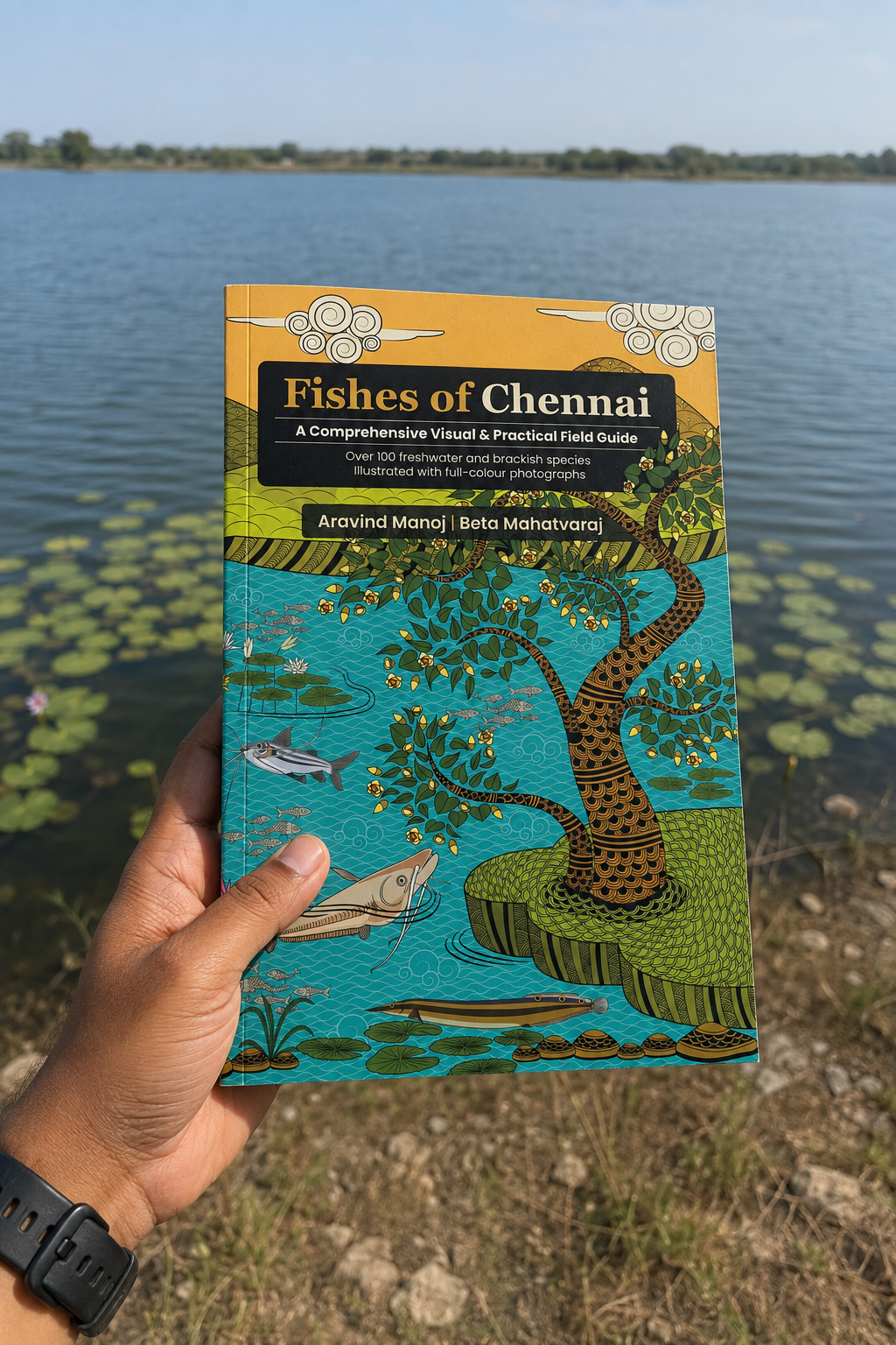
A Field Guide to Chennai’s Fishes Fishes of Chennai, written by Aravind Manoj and Beta Mahatvaraj, is the first field guide to bring together the freshwater and brackish fishes of the Chennai Metropolitan Area and its surroundings, documenting more than 100 species, from the carps and catfish you see at any market to native fish barely recorded anywhere else. The book explores each fish along with its natural history, ecology, and cultural significance, including references to fish in the ancient Tamil Sangam texts.
Fishermen Raise Concern Over Mass Idol Immersion in North Chennai The Tamil Nadu Fishermen Trade Union Federation has submitted a representation to the Chennai district collector, raising severe concerns over potential ecological damage and livelihood loss caused by the mass immersion of Vinayagar idols along the Kasimedu and Ennore coasts. The federation, in its memorandum, highlighted that a recent NGT ban on idol immersions at Pattinapakkam and Neelankarai beaches — aimed at protecting turtle nesting sites and coastal ecosystems — threatens to redirect thousands of idols directly to beaches in north Chennai.
Disappearing songs as Pulicat’s fishing life changes From traditional fishing knowledge to community rituals, a way of life is being eroded by declining catches, mechanisation, industrialisation and migration. (Joymala Bagchi)
Hyderabad doctors caution against fish fed with chicken waste A month after the Cyberabad Police seized 100 tonne of chicken waste being trucked out of the city to be fed to fish, doctors in Hyderabad are warning that the practice carries risks that go well beyond the plate – from antibiotic resistance to food-borne infection.
SAND MINING
Tripura Forest Department Shifts Sand Mining Administration The Tripura government has introduced a new administrative framework for sand mining in the state, shifting the primary responsibility for regulating and managing the activity from the Forest Department to the Industries & Commerce Department with effect from Sept. 1, 2026.
With the revised arrangement now in place, the Industries & Commerce Department and its Directorate will deal with various aspects of sand mining, including applications for mining, renewal or extension of permissions, approval of mining plans and execution of mining leases and related deeds. Regulatory and administrative matters concerning the operation of sand mining activities will also come under the new system.
The notification makes it clear that the Forest Department will no longer serve as the competent authority for routine permissions and approvals concerning sand mining under the new arrangement. However, matters that fall specifically within the Forest Department’s statutory jurisdiction or those separately assigned by the state government, will continue to remain under its purview.
Mining threatens Kataka’s groundwater, infrastructure Unregulated sand mining from the Mahanadi and Kathajodi rivers could worsen Kataka’s groundwater crisis, with the city’s water table showing a declining trend in recent years, according to research by the Department of Geology at Ravenshaw University.
Researchers studying the riverbeds said excessive removal of sand is reducing the amount of sand available in the riverbeds, which may be affecting the natural recharge of groundwater. If the trend continues, Kataka could face a severe water shortage in the coming years, they warned.
The researchers said their findings are based on satellite imagery and ground-level data collected during a four-year study of the Mahanadi and Kathajodi riverbeds. According to the study, the groundwater level remained above the standard line between 2017 and 2019 but began declining from January 2021. The researchers attributed the trend, at least in part, to the reduction of sand deposits caused by excessive extraction.
Illegal sand mining in Budhabalanga river bed The grant of a mining lease or short-term permit for sand is governed by the Odisha Minor Mineral Concession Rules, 2016 (OMMC Rules, 2016) and neither the Tental nor the Pandupal sand bed has been settled or leased under these rules; thus, any extraction would be considered illegal mining. This was stated in the report, September 7, 2026 filed by the Mining Officer, Mayurbhanj on behalf of the Additional Chief Secretary, Odisha; Steel and Mines Department, Bhubaneswar; Collector and District Magistrate, Mayurbhanj and the Deputy Director of Mines, Bhadrak.
The matter concerns illegal mining and sand lifting from the Tental and Pandupal sand beds in the Budhabalanga river, both located under the Badasahi tahasil of Mayurbhanj district. The applicant had alleged in the application filed before the NGT that the miners were extracting more than 500,000 cubic metres of sand from each site over an area exceeding 15 acres, coupled with allegations of illegal stocking of sand and cutting of river embankments.
Jajpur sand quarry under scanner On Sept. 11, 2026, NGT’s eastern bench took up the case concerning alleged violations of environmental norms in the operation of Pankapal-II sand quarry in Pankapal village, Jajpur district, Odisha. Grievance of the applicant are the illegalities and environmental norm violations by the private respondent Daitari Dhal, the lessee of Pankapal-II Sand Quarry over an area of 12.30 acres or 4.978 hectares in village Pankapal under Danagadi tahasil. The court will next take up the case on November 5, 2026.
Illegal mining plagues Ravi riverbed Illegal sand mining along the Ravi riverbed in the Ajnala-Ramdass belt has once again come under intense scrutiny, prompting the police to register multiple cases amid allegations of heavy mechanised excavation. The issue took a political turn on Sept. 18 when former Punjab minister and Shiromani Akali Dal leader Bikram Singh Majithia alleged that the Ravi was being plundered in broad daylight at Malakpur, sharing photographic evidence of Poclain machines being used to dig up sand.
‘Stop Filing Affidavits and Start Acting’: SC Reaffirming the importance of environmental flows, biodiversity conservation, and institutional accountability, the Supreme Court stressed that environmental protection requires sustained and time-bound action on the ground rather than mere administrative assurances or delayed compliance.
Illegal mining in Banda has been a long-standing issue. In this interview, Mohan Sahu talks about how he says illegal mining operates in the region, and alleges that journalists and activists who speak about the issue face arrests and pressure.
Indian sand-mining story heading to Venice Ahead of the world premiere of ‘Our Share of Sand’ at Venice Critics’ Week, the Chilean-Indian filmmaker discusses growing up between two cultures, the human cost of India’s development boom and the moral compromises that come with privilege.
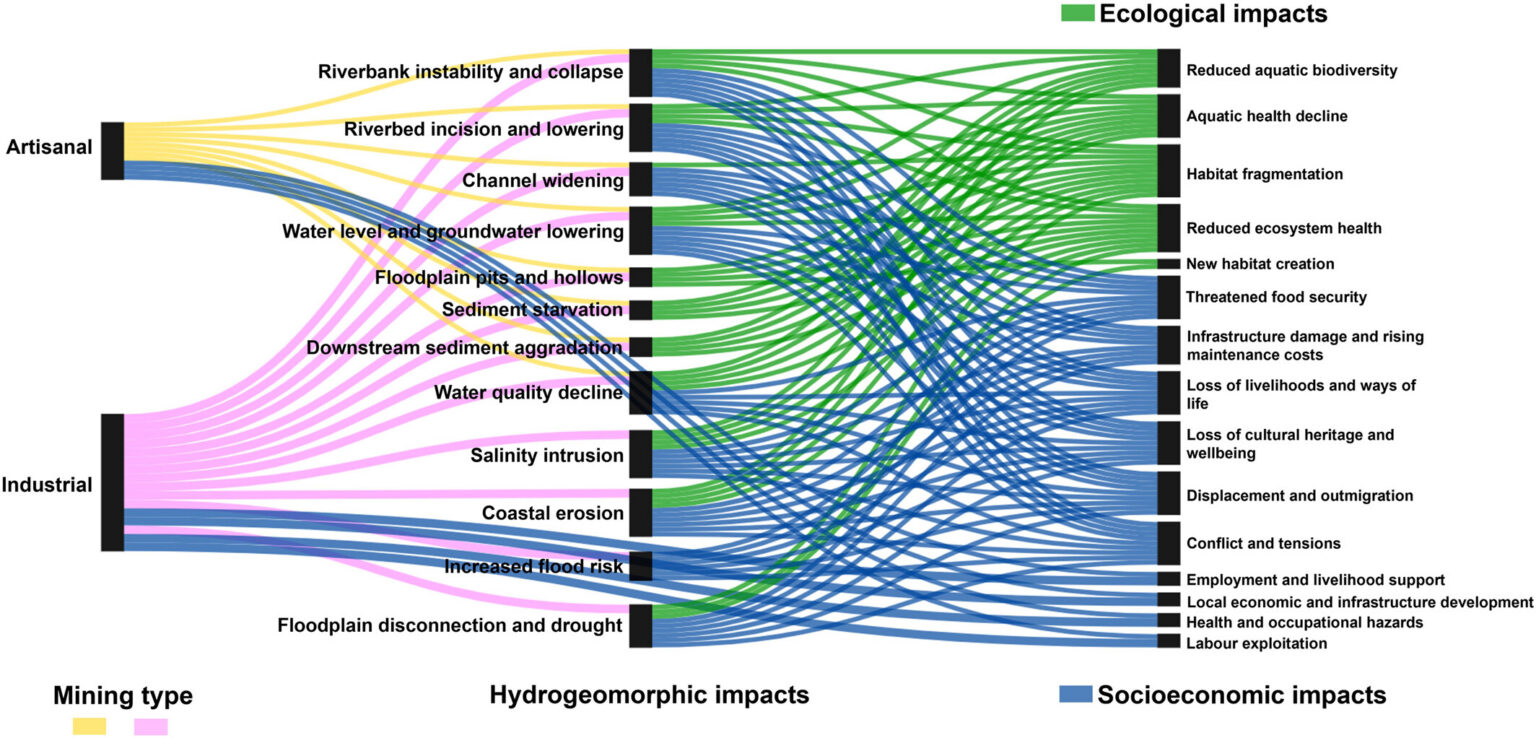
Hidden Costs of Mining River Sand A new article in Reviews of Geophysics examines where and how much sand and gravel are mined across the world, and the environmental and societal impacts. Here, we asked the authors to give an overview of sand and gravel mining, the challenges of studying the impacts, and what questions remain.
Stone crushers, quarry owners announce indefinite strike over royalty collection The stone quarry and stone crusher owners’ associations of Dakshina Kannada and Udupi have decided to commence an indefinite strike from Sept. 18, demanding the immediate withdrawal of the existing dual system of royalty collection and the implementation of a clear and uniform single policy in royalty collection. During the strike, quarrying, crushing and related supply activities will remain suspended.
Heat, silica dust wearing down workers in Jodhpur’s sandstone mines As temperatures soar across western Rajasthan, sandstone miners in Jodhpur continue working through extreme heat, silica dust exposure and chronic neglect, with little access to water, safety gear, healthcare or compensation. (Joymala Bagchi)
ARAVALLIS PROTECTION
Mining in Aravallis causes contaminated reserves With their natural cracks and fissures, the Aravalli hills have the potential to put two million litres of water per hectare into the ground every year, according to experts. This makes the range a critical water recharge zone for several areas in north-west India, where the Aravallis stretch from Delhi to Gujarat.
But decades-long mining of sedimentary rocks, such as limestone and marble, in the range has allegedly resulted in the setting up of numerous stone quarries and stone crushers near or on riverbeds and water bodies. This imperils the water security that the Aravallis once provided.
The SC-appointed panel’s report can change this by establishing ecological boundaries in the range, helping to curb mining operations. To the people impacted by mining activities, however, this looks like a distant dream, as committee members did not even visit some of the worst-affected areas.
WETLANDS, LAKES, WATER BODIES
Conservation of Champak lake The NGT Sept. 11, 2026 directed the District Wetland Conservation Committee headed by the Collector of Pachmarhi, Narmadapuram, Madhya Pradesh to scientifically demarcate Champak lake. This demarcation must consider the lake’s original area, water spread area, catchment area and buffer zone, using proper identification and mapping through geo-tagging including drone survey.
After reviewing reports from authorities, including the joint committee report, the bench of Justice Sheo Kumar Singh noted a discrepancy. The Special Authority Development Area, Pachmarhi, communicated in a letter dated December 30, 2025, that the total area of the Champak lake Pachmarhi is 43.400 hectares, while the Joint Committee Report stated the notified wetland area is approximately 23.12 hectares. The State Wetland Authority was further directed to verify and correct the area and ensure the wetland is protected.
RAMSAR WETLANDS
JK Assembly admits resolution on Hokersar wetland The Legislative Assembly has admitted a Private Member’s Resolution moved by Budgam MLA Aga Syed Muntazir Mehdi concerning Hokersar Wetland, allowing the matter to proceed towards consideration in the House. The resolution calls for an examination of the present and historical extent of Hokersar Wetland and its adjoining residential and agricultural areas, with the stated aim of clarifying boundaries and protecting the rights of affected landowners.
It also seeks a review of the operation of flood gates and the management of water levels in and around the wetland, particularly in relation to recurring inundation of residential areas and farmland. Another demand is for an assessment of the impact of water-level management on homes, agricultural crops and the daily lives of people living around the wetland.
Bridge to replace part of road on Pallikaranai marshland In the near future, there will be a time when a 2-km stretch of Pallavaram-Thoraipakkam Radial Road from Chennai One to Kamakshi Hospital junction will cease to exist. The Pallikaranai marshland will take over the seven hectares of space earlier occupied by the road, and flood waters will be able to flow without any hindrance. An elevated bridge running to a length of 2 km will be constructed in its place. The DPR for the project is getting its final touches. The proposal is to construct a six-lane elevated facility that will take off ahead of Chennai One on the Thoraipakkam side and land 100 metres ahead of the flyover at Kamakshi Hospital junction, said sources in the Highways department.
WATER OPTIONS
Ladakh: The water that could bring Tso Kar back to life Ladakh is restoring the shrinking Tso Kar Lake by redirecting glacier meltwater through natural depressions and simple, low-energy infrastructure to revive wetlands, wildlife, grazing lands, and water security.
Tso Kar, one of Ladakh’s iconic high-altitude glacial lakes, once covered nearly 11,000 acres but has now reduced to around 3,200 acres. The shrinking water body has also affected its ecosystem, with a sharp decline in migratory birds, including the famed Black-necked Crane.
The project was conceived after LG Saxena visited Tso Kar on August 10, 2026, where local villagers and the Nambardar informed him about the lake’s rapid decline and the resulting reduction in bird populations and grazing land.
Under the Tso Kar revival plan, water from the Rupsho Kharnak stream will be diverted through a series of three natural depressions located along its route towards the lake. The first depression covers around 270 acres, the second 24 acres and the third around 10 acres.
The Rupsho Kharnak stream originates at an altitude of around 18,000 feet, approximately 11 km from Tso Kar. At present, a substantial volume of its glacier meltwater flows unused into the Sindhu River. The administration expects that diverting the water could help restore the lake significantly within a year.
Kapurthala farmer replaces urea with dairy slurry in paddy fields Sukhjinder Singh of Mahabalipur village in Sultanpur Lodhi, who cultivates around 12 acres, has stopped using urea on a significant portion of his paddy crop this season and instead relied on slurry generated from the dairy farm he owns. A progressive farmer, Singh says the results have encouraged him to continue with the practice. He also runs a dairy farm with around 50 cattle. The farm has a ‘gobar’ gas plant, which generates energy used to meet the electricity requirements of his home and farm.
From temple waste to Rs 200-crore ‘Phool’ How two friends turned Ganga pollution problem into a business
URBAN LAKES, WETLANDS
No Ganesh Idol Immersion in Water Bodies From 2027: Tamil Nadu to NGT The Tamil Nadu govt has assured the NGT that Ganesh idol immersion will not be permitted at Chennai’s Foreshore Estate and Neelankarai beaches from next year. The govt has also assured the tribunal that it will aim to stop idol immersion in natural water bodies from 2027, while following directions and rules issued by the Supreme Court, Madras High Court and the NGT.
The exact scope of the statewide measure is expected to be clarified in an affidavit to be filed before the tribunal. The assurance came during the hearing of a petition seeking directions to prevent Ganesh idol immersion in water bodies because of the environmental damage caused by the practice.
The NGT on Sept. 17, again questioned the Tamil Nadu govt about its preparedness for the Vinayaka Chathurthi festival, pointing out that the State had a full year to act on the directions on idol immersion. The Madras High Court has refused to entertain a plea seeking directions to the State to take strict and time-bound measures and ensure that the guidelines with respect to idol immersion issued by the Central Pollution Control Board are followed during the Vinayaga Chaturthi celebrations.
In Hyderabad Despite an official ban on idol immersion at Tank Bund and posters by the city police, an Instagram reel has surfaced showing people scaling fences to throw idols into Hussain Sagar. The ban applies only to Tank Bund, not Hussain Sagar as a whole, with Necklace Road, NTR Marg and People’s Plaza serving as the approved immersion points instead.
URBAN WATER
High nitrate, fluoride levels in Hyderabad GW Groundwater in several parts of Hyderabad has elevated levels of nitrate and fluoride, with children facing higher potential non-carcinogenic health risks, according to a recent study. The study analyzed 44 groundwater samples collected during the pre-monsoon and post-monsoon seasons of 2023. Researchers attributed nitrate contamination largely to fertilizer use, sewage infiltration, septic-tank leakage and urban wastewater. Monsoon rainfall can also carry nitrogen compounds from the soil into groundwater, the study noted.
Dip in groundwater level, rising use strain Vizag IT hills A decline in groundwater yield, coupled with the prevailing El Niño conditions and a steady rise in consumption, has put pressure on water supply to IT and industrial establishments at APIIC’s Hill No. 2 and Hill No. 3 in Visakhapatnam.
APIIC is currently drawing around 5 to 5.2 million litres a month against the normal supply capacity of 6.5 ML. According to sources, APIIC has issued a notice to companies operating from the two hills, asking them to use water judiciously, restrict consumption to essential requirements and avoid unnecessary use until the supply situation improves.
Amid a worsening water shortage, govt is planning a series of measures to secure drinking and industrial water supplies. One of the proposals under consideration is increasing water supply from Yeleru reservoir to Kanithi balancing reservoir from 300 cusecs to 350 cusecs. Authorities are also preparing motors and pumps to draw water from Yeleru’s dead storage during emergencies if reservoir levels fall below gravity-flow requirements.
Alternative water sources are also being explored for Raiwada reservoir. Govt is examining the feasibility of lifting water from Polavaram Left Main Canal to Raiwada. Efforts are also under way to supply 100 cusecs of water from the canal to Meghadrigedda. Officials are also planning optimal utilisation of available water in Tatapudi reservoir.
As a long-term solution, govt plans to complete Polavaram Left Main Canal works and divert 17,500 cusecs of Godavari water to north coastal Andhra Pradesh from 2027. Projects such as Uttarandhra Sujala Sravanthi are also being considered to strengthen the region’s long-term water security.
DJB Jal Manthan charts roadmap for water security Delhi Jal Board’s two-day Jal Manthan 2026 concluded Sept. 16 with experts and officials focusing on improving the city’s water security and accelerating the rejuvenation of the Yamuna. Six key areas were 24×7 quality water supply, circular water economy, future-ready workforce, digital DJB, financial sustainability and Yamuna rejuvenation. The discussions focused on practical and technology-driven solutions for Delhi’s water and wastewater systems. Greater use of treated wastewater for non-potable purposes was another key area. Experts examined reclaimed-water utilisation and recovery of resources from wastewater and sludge.
MONSOON 2026
India on track for its driest monsoon in 17 years Cumulative rainfall during the June to September monsoon season is 15% below the long-term average so far, according to the India Meteorological Department. If the deficit persists, it would be the weakest monsoon since 2009, when precipitation was 18% below normal. The weather office had forecast a 10% shortfall for this season back in May.
IMD’s district wise daily 21 Sept. 2026 and cumulative 01 June to 21 Sept. 2026 Rainfall figures.
Punjab faces 39% monsoon deficit The deficit is the highest in the northern region. The latest IMD data shows that state recorded 254.2 mm of rainfall between June 1 and September 19, compared to the normal average of 417 mm. The rainfall deficit has widened despite the state recording some rainfall in September. Between September 1 and 19, Punjab received 23.6 mm of rainfall against the normal of 54.9 mm, marking a deficiency of 57%. The September shortfall has added to the seasonal deficit after below-normal rainfall in June and July, when the state received 29.5 mm and 119.3 mm, respectively.
In June, rainfall was 46% below the normal precipitation of 54.5 mm, while July recorded a 26% deficit against the monthly normal of 161.4 mm. The cumulative rainfall figures underline the contrast with last year, when Punjab received 621 mm of rainfall during the southwest monsoon season, from June 1 to September 30, against the long-period average (LPA) of 439.8 mm — an excess of 41%. The 2025 monsoon rainfall was Punjab’s highest since 1995 and the ninth-highest since 1901.
Haryana records 24% rainfall deficit Haryana has recorded 24 per cent less rainfall than normal during the current monsoon season, as per data issued by the IMD on Sept. 17. The cumulative rainfall for the state this monsoon season stands at 313.8 mm against the normal 411.6 mm, reflecting a deficit. In September, the state recorded 34.8 mm of rainfall against the normal of 58.1 mm.
Ambala has recorded a 49 per cent deficit, while the shortfall is 57 per cent in Jind, 48 per cent in Kaithal, 45 per cent in Karnal, 46 per cent in Rohtak and 53 per cent in Sirsa, the data states. Hisar witnessed a deficit of 20 per cent, Jhajjar 16 per cent, Panipat 27 per cent, Sonepat 31 per cent and Yamunanagar 18 per cent. Gurugram has recorded 1 per cent above normal rainfall. It has witnessed 477.6 mm of rainfall against the normal of 473.2 mm.
From June 1 to Sept 19, Haryana recorded a 22% rainfall deficit and Himachal Pradesh at 9%. Punjab received 254.2mm rainfall against the normal 417mm, while Haryana recorded 317.5mm against the normal 409.7mm. Himachal Pradesh received 636.4mm against the normal 701.7mm.
As many as 14 states, including Bihar, Punjab, Haryana and all five peninsular states, have reported a rain deficit of more than 20% so far. More than 30 districts across Haryana, Punjab, Rajasthan, Himachal Pradesh and western Uttar Pradesh have recorded significant rainfall deficits this season as per Sept. 17 report.
Among the southern states, Andhra Pradesh fared the worst with a 43 per cent shortage, followed by Karnataka (31 per cent), Kerala (28 per cent), Tamil Nadu (22 per cent) and Telangana (21 per cent). Some of the other states with major rainfall deficiencies are Punjab (39 per cent), Bihar (36 per cent), Haryana (22 per cent) and Rajasthan (21 per cent). The east and northeast region currently has a 26 per cent rainfall shortage compared with the region’s average, with Meghalaya (59 per cent), Manipur (43 per cent), Arunachal Pradesh (41 per cent) and Assam (26 per cent) being the worst-affected states.
Arunachal faces 41% deficit rainfall As per a report, the state received 900.4 mm rainfall against the normal rainfall of 1,535.6 mm during 1 June to 16 September, showing a 41% rainfall deficit. The average rainfall received during 1-16 September was 87.3 mm, against the normal 196.1 mm, which also indicates a 55% deficit. Last year too, the region witnessed severe rainfall deficit in the monsoon season and post-monsoon period. The drought-like situation in the Siang belt and other parts of central Arunachal invited contingency crop plans, including cultivation of cash crops and weather-resilient cereal crops to bring a little respite for the rural farmers.
For third year, Tamhini Ghat crosses 9,000 mm rainfall mark According to SD Sanap, Scientist at IMD’s Climate Research and Services in Pune, Tamhini Ghat recorded 9,018 mm rainfall as of 18 September. This makes Tamhini Ghat the wettest place in Maharashtra. The Tamhini Ghat received 5,000 to 6,500 mm rainfall on average; however, in 2024, 2025 and 2026, it crossed the 9,000-mm mark back-to-back.
The Tamhini Ghat, situated in the crest of Western Ghats ranges received 575 mm rainfall. The 15-km-long ghat section has scenic waterfalls, lakes and dense woods. From the Tamhini Ghat, one can access the Mulshi Dam backwaters. “July was the real game-changer, contributing a staggering 5,710 mm by itself, followed by another 2,602 mm during August. Even with the relatively lower rainfall during June and now even in September so far, the seasonal total has now crossed the 9,000 mm threshold. This makes Tamhini the first station in the Sahyadri Ghats region—and, based on the available observations, the first in India to cross the 9,000 mm seasonal mark during the 2026 monsoon,” added Modak.
DROUGHT 2026
Southern India drying fastest: Study A new study examining the country’s weather from 1971 to 2022 has revealed that southern India is drying the fastest, with the most persistent drought hotspots along the eastern coast. It also says that the northwest has emerged as India’s heat epicentre, with the strongest trends in daytime temperature, humid heat and heatwave severity. The study, “Evolution of Climate Extremes Over the Indian Subcontinent Using a Revised CEI”, was published in the peer-reviewed International Journal of Climatology and made public on Sept. 18. The study also reveals northwest India as the country’s heat epicentre, recording the strongest upward trends in daytime temperatures, humid heat and the intensity of heatwaves.

Tamil Nadu’s coconut belt reels under acute water scarcity If the situation persists and the North-east Monsoon fails to deliver adequate rainfall, farmers warn of a severe coconut shortage across South India by early 2027, with yields already coming down to less than 50%. Residents of the Thalavadi hills in Tamil Nadu are grappling with an escalating water crisis as drought conditions persist in the region. The scarcity is particularly acute in larger villages, which now require multiple daily tanker deliveries to meet basic needs.
FLOOD 2026
Floods affect millions in Bihar despite deficit monsoon Floods have affected around 5 million people across 15 districts of Bihar, even as the state records a 35% rainfall deficit. Experts say intense rainfall later in the monsoon, saturated soils and degraded catchments can contribute to flooding even when seasonal rainfall is below normal. Farmers have lost crops and homes, with repeated flooding also pushing young people to migrate for work.
Himanshu Thakkar of SANDRP, explains, “Initially the monsoon rainfall was very low in U.P. and Bihar. In July and parts of August, rainfall was considerably higher, particularly on different days. It is showing its impact now. In the initial monsoon period, the soil is also generally dry. So a lot of the moisture gets absorbed into the soil. But by the later part of the monsoon, the soil becomes saturated. So, whatever additional rainfall there is, it adds up as flood,” he adds.
Thakkar argues, “Catchment is degrading, which means visible deforestation, destruction of local water bodies. All of this reduces the catchment capacity to hold water. So because of the high deterioration of catchments, the rainfall is converting into runoff very fast. So, these are the reasons why you are seeing it particularly in Bihar.”
Thakkar adds that the flood situation immediately depends on the Farakka situation. Once Farakka gets filled and backwater is there, then the water from the river finds it very difficult to drain out. That creates a flood situation even when the rainfall is not very high, particularly along the Ganga and its main tributaries. Then, debris, soil, silt and sedimentation accumulate. So, this situation is going on particularly in Bihar, and this happens particularly in the second half of the monsoon, when Farakka’s situation is full.”
A Historical Understanding of Assam’s Floods In the case of the Assam floods, one must accept that flood is predetermined, which has always already occurred. The Indian government must acknowledge its ‘failure’ to understand the river’s rhythm by recognising the flood as a ‘national disaster’. The government’s need to own such failure suggests that it is only in failing that we establish a new possibility. (Jyoti Bania)
CLOUD BURSTS
Flash flood destroys fishponds, animal farms Flash flood caused by a cloudburst wreaked havoc in Ledum village and downstream Niglok and Linka villages of Pasighat West area in East Siang district on June 28, 2026 leaving several farm families affected and their lives in turmoil. The flood also washed away standing crops, livestock and household properties in Adi Leku village bordering Assam. The strong currents of the Ledum river submerged and devastated fishponds, animal farms and horticulture gardens on its left bank, causing heavy losses to the farmers of Ledum and Linka villages.
HIMALAYAN DISASTERS
Shimla residents seek independent probe into 4-lane tunnel alignment Residents of Shanti Vihar ward in Shimla, where about 10 buildings have developed cracks, have urged the Centre and the state government to order an independent investigation into the four-lane tunnel alignment between Chalounthi and Bhattakufar. They have also sought an immediate halt to tunnelling and blasting in the area.
The residents have also demanded the constitution of a committee comprising independent geologists, geotechnical engineers, structural engineers and tunnel experts to examine the entire alignment and its impact on existing houses. They have sought disclosure of the original and revised alignments, geological and geotechnical reports, reasons for changing the alignment, approvals and other relevant technical documents for affected residents.
60% of Solan-Shimla highway faces high risk: Study Landslide susceptibility mapping (LSM) undertaken by geologists along the Solan-Shimla highway in Himachal Pradesh has revealed that about 60 per cent of the 45-km stretch falls under the moderate to very high-risk category. The LSM showed that 12.83 per cent of the study area falls under the very high susceptibility category, 21.97 per cent under high susceptibility and 26.58 per cent under moderate susceptibility. About 24 per cent of the stretch falls under low susceptibility and 14.57 per cent under very low susceptibility.
ENVIRONMENT GOVERNANCE
Former bureaucrats question forest diversion & post-facto clearances In an open letter dated September 17, the Constitutional Conduct Group, comprising former members of the All India and Central Services, said large-scale diversion of forestland for development projects was causing increasing ecological risks. The group said it was non-partisan and committed to impartiality, neutrality and the Constitution of India.
According to figures cited in the letter from a July 2026 parliamentary reply, government approval was given for the diversion of about 215,943 hectares of forestland for non-forest use between 2014-15 and 2025-26. Nearly 62% of the diverted land was reportedly allocated to mining, hydropower, irrigation and road projects. The letter also noted that forest diversion increased from 74,705.68 hectares during 2014-15 to 2018-19 to 96,112.90 hectares during 2019-20 to 2023-24.
The former officials expressed particular concern over the Himalayan and northeastern states, while also pointing to proposals involving large areas of the Great Nicobar rainforest. They questioned the effectiveness of compensatory afforestation and cited the example of compensatory plantations proposed in Haryana for rainforest diversion in Great Nicobar.
The letter further highlighted the diversion of land within National Parks, Wildlife Sanctuaries and Eco-Sensitive Zones. It claimed that 97% of diversion proposals placed before the Standing Committee of the National Board for Wildlife since 2014 had been cleared. The group said 5,824 hectares inside Protected Areas and Eco-Sensitive Zones were cleared for non-forest uses during four meetings in 2024 and 2025.
Who wins at the Green Tribunal? This report presents a consolidated, all-India analysis of every appeal decided across the National Green Tribunal’s five benches — Western, Central, Principal, Southern and Eastern — between January and June 2026. Of the 119 appeals resolved in this window, it separates those dismissed on purely procedural grounds (limitation, maintainability, jurisdiction, or withdrawal) from those decided on their merits, and tracks each outcome by which side — environmental/public-interest parties or industry/proponent parties — brought the appeal. Bench-by-bench breakdowns are provided throughout. The analysis that follows sets out what the six-month docket shows.
The analysis from SAREL examined the 119 appeals filed at the five benches of the NGT between January and June. While environmental or public-interest parties filed 16 of the 119 merit appeals, the project proponent, property owner, or industry side filed 51 such appeals. More than 50 appeals were dismissed on technicalities or procedural issues and never reached a merits ruling. The report flagged dismissals on technical grounds as a major filter, as 44 per cent of all appeals were dismissed on limitation, jurisdiction, maintainability or withdrawal without any merits ruling.
The findings contrast with what the CJI said on Sept. 19 at the inauguration of the NGT’s two-day international conference on “The Future of Environment and Climate Dynamics” in New Delhi. “At present, the question before our courts is no longer conservation versus development, but rather how the two can be harmonized and sustained together,” the CJI said in his address.
SOUTH ASIA
Rapid Damage and Needs Assessment (RDNA) Rasuwa-Bhotekoshi Flood 2026 –Total damage to energy infrastructure is estimated at NPR 13,469.76 crore (USD 889.21 million), inclusive of replacement costs. Reported economic losses total NPR 1,634.69 crore (USD 107.91 million), bringing total damage and losses to NPR 15,104.45 crore (USD 997.13 million).
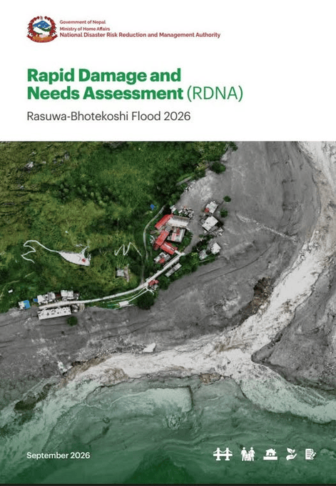
The assessed sector includes hydropower and solar projects, a substation, transmission lines, a switchyard, and distribution infrastructure. Household and community renewable-energy technologies are assessed separately in the following subsection.
Affected portfolio and pre-disaster status: – The inventory records 13 hydropower projects with a combined capacity of 759.025 MW. Seven projects, representing 250.400 MW, were operating before the disaster; six projects, representing 508.625 MW, were under construction. Five operating solar plants add a further 24.360 MW.
Approximately 67.0% of the assessed hydropower capacity was under construction. Damage therefore affects both existing electricity supply and the development of future generation. Construction-stage capacity cannot be treated as electricity generation already lost; any commissioning-delay effects require comparison with planned completion dates.
Damage profile: -Hydropower accounts for NPR 11,995.56 crore, or 89.1% of total energy damage. The remaining damage concerns solar plants and the infrastructure needed to transmit, switch, and distribute electricity. https://ndrrma.gov.np/np/study-report/416
29 bodies recovered from hydropower tunnels Twenty-nine bodies have been recovered from tunnels at two hydropower projects in Nepal, more than three weeks after devastating floods blocked the entrances, as the official death toll from the disaster rose to 1,451 and nearly 5,800 people remained unaccounted for.
Rescue teams recovered 24 bodies from the Trishuli-1 Hydroelectric Project over two days on September 17 and 18, after drilling into tunnels where workers were believed to have been trapped. Five more bodies were recovered from the Chilime hydropower project on September 16. Most of the victims have yet to be identified. Their bodies were airlifted to Nuwakot by a Nepal Army helicopter on Sept 19.
A total of three workers — two Nepali and one Chinese — were pulled alive from inside hydropower tunnels ten days after the disaster. The rescue of the three workers had raised hopes among relatives that others trapped underground might also be found alive. Those hopes have since given way to the recovery of bodies from the flooded tunnels.
Climate change likely intensified Nepal’s cascading flood disaster: WWA World Weather Attribution scientists say fossil fuel-driven warming played a role in the occurrence and intensity of Nepal’s August 26 cascading flood disaster. Researchers said climate change acted as a destabilising factor on a slope already weakened by geology, the 2015 Nepal earthquake, glacier retreat and thawing permafrost. The study said the event was beyond the design and predictive limits of existing risk-reduction measures, highlighting the limits of adaptation in rapidly warming mountain regions.
The WWA study analysed the disaster as a combination of factors, rather than as a single extreme weather event. The humongous volume of water in the flood came from several sources. The first was water released from the melting of glacial ice that fell from the mountain at an elevation of 5,150 metres above mean sea level onto the valley floor at about 3,750 m. This water was then carried forward by the river. When the rock and ice fell onto the valley floor, it generated enormous energy, producing seismic waves that were recorded as an earthquake-like signal by detectors. The mechanical energy of the moving debris melted glacial ice, which became the primary source of water in the flood.
A second source was water stored beneath the glacier. A third was water from thawing permafrost. A fourth came from the melting of buried ice on the valley floor, while a fifth came from the pressure wave generated by displaced river water ahead of the debris flood. The combination of ice, rock, water and sediment travelled about 35 km downstream, causing widespread destruction.
Nepal’s Rasuwa flood disaster is an alert to Southasia and the world Human-induced change to natural systems has hit the Himalaya and it is from here that the global alarm must be raised – but Southasia’s ability to respond has been compromised by its geopolitical divisions (By Kanak Mani Dixit)
India exports 500 tonnes of hilsa to Bangladesh in rare trade reversal Traders said hilsa from Gujarat has relatively limited demand in the Indian market because of its high roe content. However, this has made it attractive to buyers in Bangladesh, especially in Chattogram and Sylhet, where roe-filled hilsa is in high demand.
India has exported around 500 tonnes of hilsa to Bangladesh over the past two months, fish traders said, marking a reversal of the usual trade in the prized fish between the neighbouring countries. Traders said another 150-200 tonnes is expected to be sent from India in the next few weeks. The exports have come amid reports of lower hilsa production in Bangladesh this year, leading traders there to source the fish from India to meet domestic demand. Bangladesh is traditionally one of the world’s largest hilsa-producing countries, and the fish holds strong culinary and cultural importance on both sides of the border.
According to traders, the consignments have been sourced mainly from Gujarat and shipped through Bharuch port, while some supplies have also moved through the Howrah wholesale fish market in West Bengal. “Bangladesh has been importing hilsa from India for the first time. We usually send fish such as boal, rohu, parse and tangra to Bangladesh. This year there is a shortage of hilsa there,” said Syed Anwar Maqsood, secretary of the Howrah Wholesale Fish Importers’ Association.
Changing environment, mainly during the monsoon when nutrient-rich water flows into the sea, is one of the reasons. Additionally, the ideal mixing of fresh and salt water in the estuary near Bharuch along the lower stretch of the Narmada has created perfect conditions for the fish to shift towards Gujarat. “Hilsa is an anadromous migratory fish that spends most of its life in the sea but migrates towards the freshwater of rivers for breeding,” explained RB Vala and AM Parmar, assistant professors at the College of Fisheries Science, Kamdhenu University, Gandhinagar.
“The Ganga-Hooghly river system of Bangladesh and West Bengal was previously among the primary breeding grounds for hilsa. However, over time, conditions such as the Farakka Barrage, increasing construction on rivers, changes in river depth, pollution, and climate change have affected the traditional migration and breeding areas of hilsa,” the experts noted. Total hilsa production in the western state reached 14,587.72 tonnes in 2025-26, breaking a four-year record.
“In 2022-23, the state recorded a production of 14,198.98 tonnes of hilsa. Following that, it declined to 8,209.48 tonnes in 2023-24 and stood at 8,535.75 tonnes in 2024-25,” said Gujarat Fisheries Industry commissioner Vijay Kharadi. Production sharply increased in 2025-26. Inland hilsa production surged from a mere 123.62 tonnes in 2024-25 to 4,645.99 tonnes in 2025-26.
In 2025-26, Bharuch recorded a total hilsa production of 7,410.09 tons, comprising 2,949.76 tons of marine hilsa and 4,460.33 tons of inland hilsa. The district accounted for nearly 51 % of the state’s total hilsa production.
India should guarantee minimum flow in renewed GWT: Bangladesh minister India should include the 1977 “guarantee clause” in a renewed Ganga Water Treaty, thus assuring minimum flow of water downstream, Bangladesh Minister of Water Resources Shahid Uddin Chowdhury Anee has told ThePrint in an exclusive interview.
The 1996 Ganga Water Treaty is set to expire this December, and both countries are gearing up for discussions on renewing it. The guarantee clause assured a fixed minimum flow of water to the downstream country, in this case Bangladesh, during the river’s leanest part of the dry season—from 21 April 21 to 31 May.
Anee said that the clause was part of the 1977 agreement that his country signed with India, but was omitted from the 1996 treaty. “One of the things that we want when the treaty is renewed is the guarantee clause. It’s a high priority for us. The renegotiated treaty should consider the interest of both the countries,” Anee said.
Indus Waters Treaty needs modernisation Experts argue the 1960 treaty needs modernising to reflect realities it wasn’t built for: unaccounted groundwater use, climate-driven river volatility, and population growth that could nearly double demand on both sides by century’s end.
THE REST OF THE WORLD
Microplastics in soil pose global threat Microplastics act like a “Trojan horse” delivering pollutants, pesticides and bacteria through the soil, a five-year multinational research project has found. The EU-funded project, which has so far resulted in 22 peer-reviewed studies, found microplastics in the soil of all 227 agricultural fields it tested across 11 European countries. The researchers said this poses a global threat, with healthy soils essential for life on Earth. In many cases, this contamination reflected current farming practices as well as historical land use, demonstrating that plastic pollution can persist for many years.
The world’s rivers are at breaking point The Guardian launches a year-long project, Our Rivers, to take stock of the issues facing waterways around the world.
Amazon Forgotten Fishes Celebrating Amazonian fish biodiversity and its vital relationship with people and rivers.
Indigenous fisherwoman finds ‘lost’ spinach pipefish, not seen by science in 40 years.The spinach pipefish is a freshwater relative of seahorses and seadragons. It grows to about 15 centimeters (6 inches) and uses its elongated snout to catch small prey. Its coloring helps conceal it among water lilies and other plants along the banks of the Sepik, Papua New Guinea’s longest river.
SANDRP
Also see: DRP 14 Sept. 2026 & DRP 07 Sept. 2026
Follow us on: www.facebook.com/sandrp.in; https://twitter.com/Indian_Rivers


