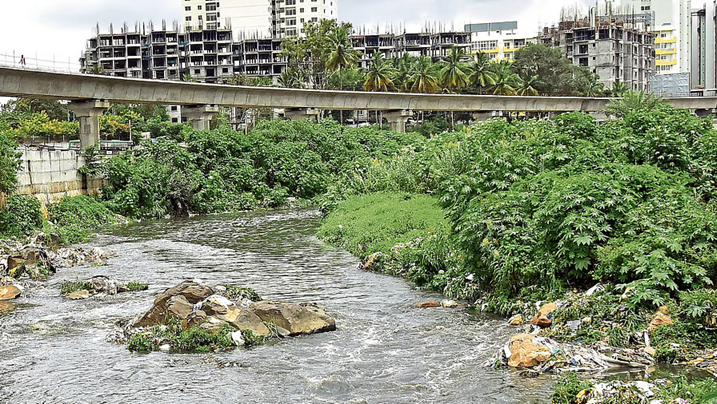
(Feature Image: Vrishabhavathi river in Bengaluru. Credit: Deccan Herald)
Despite sustaining cities with water supply, groundwater recharge, flood moderation, biodiversity, livelihoods and cultural services, India’s urban rivers continue to deteriorate, as highlighted by several reports this week. The Yamuna in Delhi remains the starkest example – ecologically dead across long stretches due to unchecked sewage inflows, shrinking flows and relentless floodplain encroachment. Similar stories are unfolding across the country, with Mumbai’s Mithi, Hyderabad’s Musi, Chennai’s Cooum, Bengaluru’s Vrishabhavathi, Ahmedabad’s Sabarmati, Vadodara’s Vishwamitri, Jaipur’s Dravyawati, Nasik’s Godvarai, Pune’s Mula-Mutha amd several other urban rivers increasingly reduced to sewage drains or heavily degraded waterways.
This decline comes despite decades of restoration programmes and thousands of crores spent under schemes such as Namami Gange, the Yamuna Action Plan, the National River Conservation Plan, and numerous riverfront development projects. Most interventions have prioritised engineering works, beautification and concretisation over ecological restoration. Untreated sewage continues to enter rivers, environmental flows remain compromised by excessive upstream diversions, floodplains are steadily encroached upon or converted into commercial and infrastructure projects, while riverfront schemes replace natural riverbanks with concrete embankments, further disconnecting rivers from their floodplains.
The continuing failure reflects non-existent river governance, lack of Urban River Policy, fragmented institutional responsibilities, poor enforcement of environmental laws, inadequate sewage infrastructure and the absence of basin-scale planning. Reviving urban rivers requires treating them as living ecosystems rather than urban real estate—by protecting floodplains and wetlands, ensuring adequate environmental flows, intercepting and treating all sewage & industrial effluents, preventing solid waste dumping and encroachments, regulating sand mining, abandoning ecologically damaging riverfront “beautification” projects, and adopting integrated river basin governance with meaningful public participation. Without these fundamental shifts, India’s urban rivers will continue to decline despite ever-increasing public expenditure.
URBAN RIVERS
How our cities are choking their lifelines From Delhi to Mumbai, Chennai to Hyderabad and Bengaluru, India’s urban rivers tell similar stories. They have been straightened, narrowed, encroached upon and increasingly turned into conduits for the waste generated by constantly expanding cities. Rivers that once shaped settlements now survive by carrying sewage. Yet every river has paid a different price.
Governments have invested thousands of crores in programs such as Namami Gange, the Yamuna Action Plan, the National River Conservation Plan and city-specific restoration projects. New sewage treatment plants, riverfronts and desilting drives are important interventions. But almost every official report arrives at the same conclusion: rivers cannot be revived by engineering alone. Unless untreated sewage is intercepted, floodplains are protected, encroachments are prevented, and ecological flows are maintained, India’s rivers will continue to shrink-even if they appear cleaner on the surface. The question is no longer whether India’s cities need rivers. They always will. The real question is whether India’s cities can continue to grow without taking away the very space that allows rivers to remain alive.
Hooghly Riverfront Needs Public-Centric Revival In an interview published on July 16, 2026, Jaismita Alexander quoted Ambuja Neotia Group Chairman Harshavardhan Neotia advocating for a people-centric revival of Kolkata’s Hooghly riverfront. He said the city’s historic relationship with the river weakened as ports, railways and trade infrastructure restricted public access. With commercial river traffic declining, Neotia argued that Kolkata now has an opportunity to reclaim and open up its waterfront for citizens while respecting the river’s natural character. Drawing on the group’s experience in developing Raichak on Ganges, he stressed that riverfront projects should celebrate rather than reshape the river. He also called for coordinated efforts among the Centre, the West Bengal government, railways and port authorities to reorganise riverfront land, including old industrial sites where feasible, to improve public access while preserving heritage. Although he noted improvements in the Hooghly’s cleanliness due to better waste management, he emphasised that the river’s greatest value lies beyond development and should be protected.
Farmers Seek Restoration of Kondalampatti Check Dam On July 25, 2026, farmers in Salem urged the Tamil Nadu government to restore the partially damaged check dam on the Kondalampatti anaicut stretch of the Thirumanimutharu River, alleging that damage caused during the Thirumanimutharu River Beautification Project has disrupted water diversion to Kottanathan Lake and the downstream Poolavari Lake, leaving both water bodies dry despite heavy rainfall. They said the damaged structure no longer retains water for diversion through the Neikkarapatti head sluice, while overgrown supply channels and untreated effluent discharge have further reduced water flow and quality.
Himachal HC Pulls Up Officials Over Riverbank Waste Dumping Hearing a batch of public interest petitions, a Division Bench led by Chief Justice G.S. Sandhawalia observed that dumping waste near rivers and ecologically sensitive areas violates the Solid Waste Management Rules, 2016 and poses a major pollution risk, especially during the monsoon when waste is washed into water bodies. Reports submitted by District Legal Services Authorities revealed illegal dumping along the Beas, Ravi, and Sutlej rivers, as well as in several khads and drains.
The Court directed the immediate relocation of a solid waste management plant located dangerously close to the Sutlej River at Sunni, ordered a fresh feasibility assessment for a new Material Recovery Facility (MRF) site in Rampur after the previous facility was damaged by fire, and instructed Deputy Commissioners of Shimla, Chamba, Bilaspur, Kangra, and Kullu to clear identified waste hotspots and submit compliance reports.
The Court also ordered the prompt recovery of outstanding garbage user charges, noting that only a small fraction of the dues had been collected.
NGT Questions Ganga Floodplain Demarcation in Varanasi On July 22, 2026, the NGT directed the National Mission for Clean Ganga (NMCG) to clarify the basis for using 1-in-5-year and 1-in-25-year flood return periods to demarcate the Ganga floodplain in Varanasi, observing that this appears inconsistent with the River Ganga (Rejuvenation, Protection and Management) Authorities Order, 2016, which defines the floodplain based on the 1-in-100-year highest flood level.
The order came during the hearing of a case alleging illegal construction by M/s Sri Wari Chemicals Pvt. Ltd. within the active floodplain at Ramghat, Varanasi. The NMCG informed the tribunal that it had asked the Uttar Pradesh government to undertake hydrological and technical studies in line with the Central Water Commission’s July 2025 guidelines, but the NGT noted that these guidelines were not placed on record and granted four weeks to produce them. The tribunal also allowed the Ministry of Jal Shakti and the Central Water Commission to be impleaded as parties. The next hearing is scheduled for September 21, 2026.
Supreme Court Stops Vrindavan RFD The Supreme Court on 21 July 2026 ordered a status quo on all construction activities along the Yamuna river in Vrindavan, expressing concern that ongoing works could reduce the river’s channel width and affect its ecological flow. A Division Bench of Justice J.B. Pardiwala and Justice K.V. Viswanathan termed the situation “very serious” and emphasized the need to protect the natural flow of the Yamuna.
The order was passed while hearing Ashok Kumar Sinha v. Union of India & Ors. (Civil Appeal No. 3367/2020), after two interlocutory applications highlighted construction activities near the Yamuna that could lead to river channel shrinkage. The Court directed that a detailed report on the issues raised must be submitted before the next hearing scheduled for 23 September 2026. The Court’s status quo order prevents any further construction in the affected area until further directions. The matter relates to concerns over possible encroachment and alteration of the Yamuna river space in Vrindavan.
NGT Examines Vrindavan RFD Violations The NGT on 10 June 2026 took cognizance of allegations that the ongoing Yamuna riverfront development project at Keshi Ghat, Vrindavan was being carried out beyond the environmental permissions granted by authorities.
The petition alleged that construction by the Uttar Pradesh Irrigation and Water Resources Department exceeded the approved scope, with works reportedly extending into the Yamuna river channel. The applicant argued that permissions from the NMCG and Taj Trapezium Zone (TTZ) Authority were limited to restoration and beautification of the existing ghat and did not allow additional construction inside the river area.
The NGT observed that the matter involved significant questions related to environmental compliance and issued notices to concerned authorities. It directed the department to strictly follow the conditions of existing approvals and sought replies from the respondents. The case will examine whether the Vrindavan Yamuna riverfront works comply with ecological safeguards and permissions intended to protect the river ecosystem and floodplain.
CPCB Finds Garbage Dumped at 33 Yamuna Riverbank Sites A Central Pollution Control Board (CPCB) report submitted to the NGT on July 22, 2026, revealed that solid waste was found at 33 of 52 monitored locations along the Yamuna River, Sahibi River (Najafgarh Drain), Shahdara Drain, and their tributary drains between May 2025 and April 2026. The monitoring, carried out jointly by CPCB, the Delhi Pollution Control Committee (DPCC), and the Delhi Jal Board (DJB), highlights continued illegal dumping despite ongoing Yamuna clean-up efforts.
Following the findings, CPCB and DPCC directed multiple civic agencies to remove waste, prevent further dumping, and submit action-taken reports. The matter came under NGT scrutiny after a media report alleged that waste from the Okhla landfill was being dumped along the Yamuna floodplain. The CPCB also reported that, despite extensive biomining, 109.37 lakh metric tonnes of legacy waste remained at Delhi’s Bhalswa, Ghazipur, and Okhla landfill sites as of May 31, 2026, underscoring the city’s continuing solid waste management challenge.
Delhi’s Yamuna biologically dead A comparison of Delhi Pollution Control Committee (DPCC) water quality reports from May 2025 and May 2026, published this month, shows that while pollution indicators have improved marginally at a few locations, the river remains biologically dead across much of Delhi.
The deterioration comes weeks after CM launched the ‘Clean Delhi with CM’ campaign at Chilla village, calling the Yamuna a river revered by millions and promising its scientific and sustainable rejuvenation. The government has announced plans to modernise sewage treatment plants, expand sewer networks and tap drains carrying untreated wastewater into the river in a phased manner. Yet the latest DPCC data suggests these measures have not yet translated into meaningful improvements in water quality.
RIVERS
NMCG framework for small rivers conservation The Small rivers need distinct conservation strategy, says NMCG draft framework. The framework prioritises natural connectivity, catchment restoration, local water storage and nature-based solutions tailored to local ecosystems. NMCG DG Rajiv Kumar Mital said the Namami Gange framework, built around the pillars of “Nirmal Ganga” and “Aviral Ganga”, cannot be directly applied to small rivers. While uninterrupted flow may be a priority for urban small rivers, the focus in rural areas should be on restoring natural connectivity, catchment treatment and local water storage.
Mital said community participation has to go beyond awareness and translate into direct responsibility, as small rivers are closely linked to the everyday lives of local communities. He said sustaining the revival of small rivers over the long term is a greater challenge than restoring them initially and stressed that the framework addresses issues such as connectivity restoration, geomorphological correction, pollution and climate-related interventions.
Energy-positive wastewater management in urbanizing tropical cities Abstract: Urban wastewater and organic waste management are critical challenges in rapidly urbanizing regions, particularly in tropical developing countries such as Kanpur and India. Conventional treatment methods, such as the activated sludge process (ASP), face limitations, including high energy demands, low efficiency in industrial contaminant removal, and excessive sludge production. This study proposes an integrated system that combines direct membrane filtration (DMF) with anaerobic digestion (AD) to address these issues.
The DMF+AD system concentrates wastewater organics for codigestion with food waste, enhancing biogas production while reducing pollutant discharge. The results indicate a 58 % COD recovery rate, an 83 % reduction in contaminant discharge into the Ganges River, and significant improvements in effluent quality compared to those of the ASP. Additionally, economic assessments reveal that biogas energy production offsets operational energy requirements and costs, making this approach both sustainable and cost effective. This innovative system has potential as a scalable solution for urban waste management in fast-growing tropical cities, contributing to environmental protection and renewable energy generation.
The study devotes considerable attention to impacts on the Ganges River, particularly during low-flow summer periods when pollutant concentrations become most severe. During monsoon conditions, river discharge volumes dilute wastewater impacts substantially. But in summer, untreated sewage dramatically increases COD, suspended solids, and nutrient concentrations.
What makes this study particularly important is that it does not merely propose another incremental upgrade to wastewater treatment. It suggests a fundamentally different philosophy. The central insight of the study is difficult to ignore: cities are currently paying to destroy energy-rich organic matter through inefficient sewage systems while simultaneously struggling with energy shortages, landfill overflows, and river pollution.
If sewage can become fuel rather than waste, urban infrastructure economics could change dramatically. Kanpur — long associated with some of the worst industrial pollution in India — may unexpectedly offer a glimpse of what the next generation of sustainable Indian cities could look like.
Sutlej’s Declining Flows Turn River into a Chemical Channel In this commentary, environmentalist Col. Jasjit Singh Gill (Retd.) argues that the Sutlej River has become ecologically dead due to decades of flow regulation, excessive water diversion, and unchecked pollution. He notes that during the lean season, the river carries only about 640 cusecs of ecological flow instead of its natural flow of around 4,000 cusecs, leaving it unable to dilute untreated sewage, industrial effluents, and agricultural runoff. As a result, the river has effectively turned into a “chemical cocktail” of pollutants, threatening aquatic ecosystems and downstream water quality. The author contends that restoring adequate environmental flows, curbing pollution at source, and revisiting inter-state water allocation and river management policies are essential to revive the Sutlej’s ecological health and ensure sustainable water security.
SC Seeks Rajasthan’s Reply on Industrial Pollution On July 24, 2026, the Supreme Court expressed serious concern over widespread industrial pollution in Rajasthan and directed the state government to file comprehensive affidavits addressing allegations of untreated industrial effluents contaminating rivers, groundwater, agricultural land and wildlife habitats. Hearing the suo motu case on pollution in the Jojari River, a bench of Justice Vikram Nath and Justice Sandeep Mehta observed that the reported environmental degradation indicated a possible systemic failure in enforcing environmental laws. The Court directed the state to explain why stricter provisions under the Bharatiya Nyaya Sanhita (BNS), 2023 and the Prevention of Damage to Public Property Act, 1984 had not been invoked against polluting industries and ordered immediate action in pending and future prosecutions.
It also directed that the Common Effluent Treatment Plant (CETP) at Sangariya and associated industries should not resume operations without prior court approval, except for supervised treatment and disposal of accumulated effluents. The Court accepted recommendations to transfer identified land in Jodhpur to the Forest Department for ecological restoration, allowed genuinely zero-discharge “White Category” industries to seek de-sealing after inspection, and held the Chief Secretary of Rajasthan personally responsible for ensuring compliance with its directions. The next hearing is scheduled for August 4, 2026.
NGT Raises Concern Over Pouring of 11,000 Litres Milk into Narmada A joint committee report submitted by MPPCB stated that available studies did not show a measurable adverse impact on Narmada’s water quality due to its flowing nature, high dilution capacity, natural assimilation and continuous reaeration. However, it noted that milk is an organic biodegradable substance with oxygen demand, and releasing such large quantities directly into water bodies is environmentally undesirable, especially in stagnant or low-flow systems.
The committee recommended that religious gatherings along the Narmada should be organised only with prior permission, at designated ghats, and follow the 2024 Standard Operating Procedure for river-sensitive gatherings. Event organisers should coordinate waste management, sanitation, crowd control and environmental protection measures. The NGT observed that there is currently no law prohibiting milk offerings during rituals, but emphasized that dumping large quantities of milk into rivers should be avoided, particularly in areas where water flow is limited and pollution risks are higher.
SC Gives Bihar Six Weeks to Clear Ganga Encroachments The Supreme Court has directed the Bihar government to remove all unauthorized structures and encroachments along the stretch between Nauzar Ghat and Nurpur Ghat in Patna within six weeks. The bench said the matter required immediate attention after being informed that no effective steps had been taken despite earlier directions.
The bench of Justice J.B. Pardiwala and Justice K.V. Viswanathan expressed concern over the continued inaction. Referring to the record, the bench observed, “We are informed that till this date, no steps have been taken to remove the encroachments.” It further directed that “Any laxity in this regard will be viewed strictly.”
The Court also granted the Union one final opportunity to collect complete information from all States, warning that Chief Secretaries could be summoned if the required details were not furnished.
The court sought a compliance report “by a competent authority by the next date of hearing” and warned that “any laxity in this regard will be viewed strictly”. The court was hearing an appeal filed by one Ashok Kumar Sinha, through Advocate Akash Vashishtha, challenging the June 20, 2020 judgment of the National Green Tribunal dismissing his plea for action against the encroachments along the stretch of the river. Vashishtha highlighted that in 2023, 213 encroachments were identified on the stretch between Digha Ghat and Nauzar Ghat. Next likely on September 23, 2026.
HYDRO POWER PROJECTS
Sikkim: 25 Workers Killed in NHPC Teesta-VI HEP Tunnel Disaster NHPC’s Teesta Stage-VI tunnel disaster has become one of the deadliest accidents in India’s hydropower construction sector and another stark reminder of the multiple hazards associated with large infrastructure development in the fragile Himalayan region.
Beyond the tragic loss of 25 lives, the latest disaster highlights the urgent need for stronger geological investigations, continuous hazard monitoring, real-time gas detection, robust ventilation systems, independent safety audits and specialised underground rescue preparedness at major tunnelling projects.
ACT Begins Four-Day Teesta Protection March On July 24, 2026, the Affected Citizens of Teesta (ACT) began a four-day foot march from Phidang in Dzongu to Melli to mark 19 years of its movement against hydropower development and in support of protecting the Teesta River under the theme “Teesta Matters to Me.” After a traditional Lepcha ritual, activists, local residents and supporters set out to raise awareness about the environmental and social impacts of dams in Sikkim. ACT General Secretary Gyatso Lepcha said the movement represented all citizens of Sikkim, alleging that hydropower projects have led to land subsidence, environmental degradation and increased risks in the fragile Himalayan region.

Referring to the recent methane gas explosion during tunnel excavation at the Teesta Stage VI Hydropower Project, he said the incident highlighted the hazards associated with large-scale hydropower construction and reiterated the demand to allow the Teesta to flow in its natural course. Participants also highlighted the continuing hardships faced by communities after the 2023 Teesta GLOF, including damaged connectivity, inadequate accountability and unresolved compensation issues. The march will conclude at Melli, where ACT plans to submit a memorandum to the Governor and CM outlining its demands.
July 2026: Recurring Artificial Lake Floods Lippa in Sutlej Basin The recurring formation of an artificial lake at Lippa in Sutlej basin highlights the increasingly dangerous interaction between extreme rainfall, the fragile Himalayan landscape and hydropower project. While the immediate trigger has been intense monsoon-induced flash floods, the repeated impoundment of water points to deeper issues of inadequate drainage, poor muck disposal and the cumulative impacts of hydropower development in the basin.
Unless these underlying causes are addressed through comprehensive management, scientific muck disposal, restoration of natural drainage channels and continuous monitoring of vulnerable mountain streams, Lippa is likely to remain exposed to recurring artificial lakes, placing homes, public infrastructure and local livelihoods at risk every monsoon.
Alert Issued Over Expanding Landslide Lake in Sainj Valley The Kullu district administration has intensified monitoring of an expanding landslide-dammed lake near Sharan village in the Jiva Nala, Sainj Valley, Himachal Pradesh, after fresh monsoon-triggered landslides further blocked the natural flow of water. The lake, formed in 2023 following a major hillside collapse, has continued to grow each year. A 12-member State Disaster Management Authority (SDMA) team inspected the site, documenting conditions and evaluating technical measures to reduce the risk of a potential breach. Although some water is escaping from one side of the lake, a large volume remains impounded, raising fears of sudden flash flooding that could threaten downstream villages along the Jiva Nala and Pin Parvati rivers. The administration said it is assessing the level of risk and will take appropriate preventive measures as the monsoon progresses.
Sharan Landslide Continues, Lake Risk Grows Continuous landslides near Sharan in the Sainj Valley have increased concerns over the expanding landslide-dammed lake that has been forming over the past three years. For the last two days, rocks and debris have been falling from the hillside, raising fears that further debris could completely block the stream, causing the lake to expand further. Local residents warned that if a flash flood occurs in the nallah, the impounded water could breach the natural dam and trigger downstream flooding. They have urged the administration to take timely preventive measures to reduce the risk to downstream settlements.
SDRF Inspects Landslide-Dammed Lake A 12-member State Disaster Response Force (SDRF) team inspected the landslide-dammed lake near Sharan village in the Jeeva Nallah, Sainj Valley, on July 24, 2026, after trekking nearly four hours to assess the potential risk. The team documented the site through photographs and videography, examined possible technical measures to reduce the hazard, and prepared a report for the Kullu district administration. The lake, formed after a major landslide in 2023, has continued to expand each monsoon due to recurring slope failures.
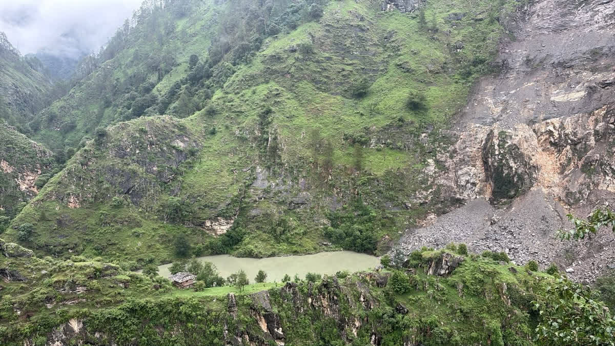
Landslide Raises Risk at Sharan Lake Local residents warned that continued rainfall or a flash flood in the nallah could breach the lake, posing a threat to settlements along the Jeeva Nallah and Parvati River, including Nadahara Bihali, Siund, Soti, Sainj, Bakshahal, Kharatla, Tarehda, Talada, Sapangni, Bihali, and Larji. While water is currently seeping through one side of the lake, the administration said it has been informed of the situation and, for now, does not consider it an immediate major threat.
Following the June 25, 2025 cloudburst in Jeeva Nallah, the Parvati River rose by as much as 10 metres at several locations, posing a serious threat to downstream settlements and hydropower infrastructure in Himachal Pradesh. The 800 MW Parbati-II Hydroelectric Project (NHPC) and the 100 MW Sainj Hydroelectric Project (HPPCL) were severely affected by debris flows. Debris blocked the tailrace channel of the Sainj project, shutting the powerhouse outlet, while boulders accumulated outside the Parbati-II powerhouse, disrupting power generation for several days. The 520 MW Parbati-III Project also witnessed heavy silt and debris accumulation in its reservoir. The 126 MW Larji Hydroelectric Project faced a dual impact from high sediment loads in the Beas and Parvati rivers.
Further downstream, the Bhakra Beas Management Board (BBMB)’s Pandoh Dam received large volumes of debris from the Beas River and Bakhli Khad, affecting the Sundernagar Balancing Reservoir and the 990 MW Dehar Power House. Silt deposits raised the balancing reservoir bed by about 13 feet, disrupting electricity generation during the monsoon. Sedimentation is also reducing the storage capacity of the Pong Dam due to silt carried by the Beas and Uhl rivers.
Landslide Near Chamera-III Dam Site Injures 3 Workers On July 25, 2026, a major landslide triggered by continuous heavy rainfall struck near Kharamukh on the Pathankot–Bharmour National Highway in Himachal Pradesh’s Chamba district, narrowly averting a serious disaster at the NHPC Chamera-III Hydropower Project dam site. Large rocks and debris suddenly fell from a hillside while around 25 workers were engaged in routine work, forcing them to flee to safety. Three workers sustained minor injuries and received first aid, while no serious casualties were reported. NHPC General Manager Tikeshwar Prasad confirmed the incident, stating that the workers’ quick response prevented a major tragedy and that all the injured are in stable condition.
Heavy Rain Damages Chanju-3 Hydropower Project On July 19, 2026, heavy rainfall in the Churah area of Chamba district, Himachal Pradesh, caused the river to swell, resulting in significant damage at the under-construction Chanju-3 Hydropower Project. The rising river washed away large quantities of construction materials, while additional materials were buried under debris. According to a preliminary revenue department report, steel reinforcement bars, aggregates, river sand, crusher sand, wire crates used for protection works, tin sheds and other temporary structures were damaged. Ground subsidence beneath the tin sheds also caused structural cracks. The district administration has begun assessing the losses and is preparing a report for relief and further action, while monitoring safety at the project site.
Last year, on July 22, 2025, a landslide triggered by heavy overnight rainfall caused extensive damage at the under-construction 48 MW Chanju-3 Hydropower Project. Machinery belonging to the construction contractor was buried under debris, while the project’s store and office buildings were damaged by falling rocks. The damage was discovered by workers the following morning. The company estimated losses at around ₹32 lakh. No casualties were reported, but the incident disrupted construction activities and heightened concerns over increasing landslide risks in the area amid continuous heavy rainfall.
Ratle HEP Cofferdam Damaged by Rising Chenab On July 23, 2026, continuous heavy rainfall across Jammu and Kashmir caused a sharp rise in the Chenab River, damaging the temporary cofferdam at the under-construction 850 MW Ratle Hydroelectric Power Project in Kishtwar district. The cofferdam, built to divert river flow during construction of the main dam, was affected by increased discharge from the upper catchment.
Project authorities deployed technical teams to assess the damage, strengthen safety measures and evaluate any impact on construction timelines. No casualties or injuries were reported. Earlier the same day, gates of the upstream 540 MW Kwar Hydroelectric Project were opened due to rising water levels, further increasing the Chenab’s discharge downstream. The report noted that this is not the first time the Ratle project’s temporary cofferdam has been damaged by high river flows.
DAMS
How dams are influencing plankton blooms along India’s coasts A new study links increasing sea sparkle blooms in Indian coastal waters to declining river borne silica caused by dams, revealing how altered sediment flows are reshaping marine ecosystems and fisheries.
Telangana seeks Centre’s technical guidance on KLIP barrages Despite the National Dam Safety Authority (NDSA) making it clear that the decision on pumping water from the Annaram and Sundilla barrages rested with the State government, the Congress government has decided to seek technical guidance on the future operation of the three barrages. Irrigation Minister N Uttam Kumar Reddy on Friday directed officials to immediately write to the Union Ministry of Jal Shakti and the NDSA seeking technical advice.
At a review meeting with senior irrigation officials, the Minister reiterated that the Telangana government had been maintaining the barrages in free-flow condition in accordance with the NDSA’s recommendations to address safety concerns.
Interestingly, officials also informed the Minister that recent statements by the Union Minister for Jal Shakti and the Ministry’s correspondence had reiterated the general policy that operational decisions on barrages rested with State governments. However, they said the communications did not specifically address the NDSA’s recommendation to maintain the structures in free-flow condition.
Chief Engineer Inspects Mullaperiyar Dam On July 25, 2026, Tamil Nadu Water Resources Department Chief Engineer S. Sivakumar inspected the Mullaperiyar Dam and its associated structures, including the main dam, baby dam, earthen dam, spillways and gallery sections, as part of a routine safety assessment. Officials stated that the visit was a routine exercise to assess the condition of the dam’s infrastructure and monitoring systems.
Ganol Dam drill sparks viral rumours of breach On July 24, 2026, a mock disaster management exercise at the Ganol Dam in Meghalaya’s West Garo Hills was disrupted after false social media messages claiming that the dam had breached spread rapidly, triggering panic among residents in the Tura region. The drill, organised by the Meghalaya Power Generation Corporation Limited (MePGCL) and the District Disaster Management Authority (DDMA), was meant to test flood preparedness and evacuation procedures in downstream villages. As misinformation spread during the exercise, authorities issued urgent clarifications confirming that the dam was safe and appealed to the public to ignore unverified social media posts and rely only on official advisories.
Agenda of MoEF’s Expert Appraisal Committee on River Valley Projects to be held on July 30 2026
1. 240 MW (1 x 120 + 2 x 60 MW) Tilari Pumped Storage Project Located at Kodali Village, Chandgad Taluka, District Kolhapur– Terms of References
2. Gandikota Pumped Storage Project (1800 MW), Andhra Pradesh by Adani Renewable Energy Fifty One Limited- Terms of References
3. Nar Par Girna River Link Project, Taluka Surgana, Dist: Nashik, Mah – Terms of References
4. Kalu Patti PSP is a pumped storage scheme 1000 MW, Uttar Pradesh by Renew Hydro Power Pvt Ltd – Terms of References
5. PEN Off-Stream Closed Loop Pumped Storage Project, Maharashtra – by Torrent Energy Storage Solutions Private Limited – Terms of References
6. Bilaspur Closed Loop Pumped Storage Project (1000 MW) in Bilaspur Dist, Chhattisgarh by Jindal Green PSP 1 Pvt Ltd – Amendment in TOR
7. Basania multi-purpose project (CCA 8780 and 100MW) in 7203.95 Ha Village Odhari, Tehsil Ghugari, Dist Mandla, (Madhya Pradesh) by NVDA – Amendment in TOR
INTERLINKING OF RIVERS
Ken-Betwa: Protest ends but questions remain There is another fundamental contradiction. The project is presented as a solution to water scarcity, yet it involves the destruction of around three million trees. If the projected benefits of the Ken-Betwa Link Project prove uncertain, an obvious question arises: could its estimated budget of ₹45,000 crore produce better results if invested differently?
Bundelkhand possesses a rich heritage of traditional water tanks, ponds and other community-managed water bodies built over several centuries. These structures embody the accumulated wisdom and engineering skills of generations of local communities. Restoring and modernizing them offers a highly cost-effective means of enhancing water security.
Having worked as a journalist and author in more than 100 villages across Bundelkhand, I believe there is considerable evidence that the same financial resources could achieve better and more sustainable outcomes in irrigation, drinking water supply and renewable energy through decentralized, locally adapted approaches. Such alternatives could be implemented more quickly while avoiding the massive ecological and social costs associated with the Ken-Betwa Link Project, including the felling of approximately three million trees. These trees can still be saved. They should be. (Bharat Dogra)
Bhatnagar ends fast after 18 days Activist Amit Bhatnagar suspended his fast on July 23, 2026 after the government’s assurance to include the people left out of the rehabilitation process. After breaking his fast, Mr. Bhatnagar said that he took the decision as several tribal women who had been part of the protest had also stopped eating since July 19 when the police forcibly took him to a hospital and dismantled the demonstration site on the banks of Barana river in Kupi village of Madhya Pradesh’s Chhatarpur district. He had been in the Chhatarpur district hospital since then and continued his fast.
Ken Betwa Protests On July 19 the police dispersed a peaceful protest against the Ken-Betwa Link Project in Chhatarpur district of Madhya Pradesh, while the protest movement’s leader Amit Bhatnagar, who has been on an indefinite fast close to two weeks, was moved to a hospital. As reported on July 20, he stated soon after being taken to hospital that his fast will continue. (By Bharat Dogra) Amit Bhatnagar, who had been leading the agitation, claimed the agitation was disrupted as he was about to expose corruption in the Ken-Betwa link project. Bhatnagar had been arrested in May by the Panna police and later secured bail. From rehabilitation and compensation to environmental concerns, here’s what is driving the protests against the Ken-Betwa river-linking project.
IRRIGATION
Karnataka Urges Farmers Not to Use Canal Water On July 25, 2026, the Karnataka government appealed to farmers in the Cauvery command area not to use water being released through irrigation canals for agricultural purposes, clarifying that the limited release from the Krishna Raja Sagar (KRS) reservoir was meant exclusively to meet drinking water needs by replenishing tanks and lakes. The appeal comes amid a severe rainfall deficit, declining reservoir storage and widespread groundwater depletion, prompting the state to prioritise drinking water supply. However, farmer representatives demanded separate releases for irrigation, saying standing crops, particularly sugarcane, are at risk without adequate water.
RIVERS BIODIVERSITY
Pregnant Gangetic Dolphin Rescued in UP On July 22, 2026, the National Mission for Clean Ganga (NMCG) announced the successful rescue of a pregnant Gangetic dolphin that had been trapped for three days in a canal at Partawal in Maharajganj district, Uttar Pradesh. The 7.2-foot-long, 147-kg dolphin was rescued through a coordinated operation involving the Uttar Pradesh Forest Department, Gorakhpur Zoo, TSA Foundation, the Irrigation Department and the police. A 20-km green corridor was created to enable the Ganga Dolphin Rescue Ambulance to transport the animal 52 km for its safe release into the Rapti River. NMCG described the Gangetic dolphin as a key indicator of the Ganga’s ecological health and noted that the rescue ambulance, introduced under the Namami Gange program, had also been used successfully in a similar dolphin rescue in Gonda district earlier this year.
Dolphin Trapped in Canal to Be Rescued A Gangetic dolphin became trapped in fishermen’s net in the Deoria Branch Canal near Ahirauli village in Maharajganj district, Uttar Pradesh, on July 18, 2026. The fishermen carefully freed the dolphin without injuring it and released it back into the canal. After inspecting the site, the Forest Department decided to rescue the dolphin from the shallow canal and relocate it safely to the Rapti River. A Turtle Survival Alliance (TSA) team was scheduled to assess the situation and assist in the rescue operation. Forest officials said the dolphin had strayed into a low-water stretch of the canal, prompting the relocation decision.
FISH, FISHERIES, FISHERFOLKS
Mass Fish Death Reported in Yamuna at Gausganj On July 22, thousands of dead fish were found floating along a 5-km stretch of the Yamuna River from Nayapurwa to Manki Ghat in Gausganj, Kanpur Dehat, Uttar Pradesh, alarming local residents. According to the Fisheries Department, the fish kill may have been caused by polluted or chemical-laden water flowing from upstream, which likely increased the biochemical oxygen demand (BOD) and reduced dissolved oxygen levels in the river.
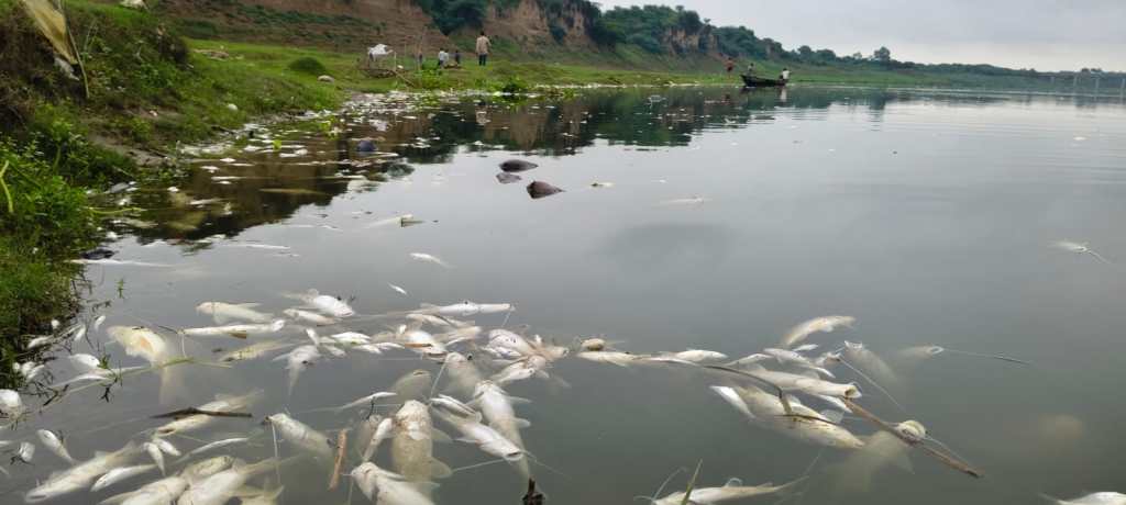
Officials from the Fisheries Department and the Pollution Control Board collected water samples and launched an investigation. They noted that there are no nearby industrial units, indicating that polluted runoff, silt, and waste carried from upstream areas may be responsible. The exact cause will be determined after laboratory analysis.
The large-scale fish mortality during the breeding season has raised concerns about the survival of fish species. The Fisheries Department has begun an investigation to determine the exact cause of the deaths. To protect fish populations during their breeding season, fishing and riverbed mining are completely prohibited from June 1 to August 31 every year.
Regional Pollution Control Officer Manoj Chaurasia said that during the monsoon, silt and various types of waste are washed into the river, adversely affecting aquatic life. He noted that there are no industrial units near the site where the fish died, suggesting that polluted water may have flowed in from upstream areas. He added that low water levels and stagnant conditions along the riverbanks may have increased the concentration and impact of harmful substances, leading to the mass fish deaths.
SAND MINING
River Sand and Gravel Mining: Global Drivers, Impacts, and Pathways for Sustainable Management We reviewed 411 scientific studies published since 1974 to examine where sand mining occurs, how much is extracted, and what environmental and social impacts it causes worldwide. We show that most mining now occurs in rapidly developing parts of Asia and Africa, yet reliable data on how much material is removed are scarce and often under-reported. Where measurements exist, extraction typically exceeds natural sediment supply several-fold, triggering river-bed incision, bank collapse, declining groundwater tables, deteriorating water quality, and coastal salt intrusion. These physical changes cascade into ecological losses, damaged infrastructure and livelihood insecurity for river-dependent communities. Research effort itself is uneven: 69% of studies document impacts, but only 27% map where and how much is mined, and just 24% investigate the socioeconomic drivers of demand. Most studies focus on physical and hydrological impacts, while socio-ecological implications receive less attention. Robust monitoring, harmonized trade statistics and management approaches that tie extraction to river replenishment rates are urgently needed to support sustainable sand and gravel mining.
The study analysed 411 scientific publications spanning five decades. The study cites examples from the Mayurakshi, Gaula, Sutlej, Ajay, Cauvery, and Kollidam rivers, where excessive mining has altered river morphology, destabilised channels, and increased flood risks. It also highlights that illegal mining continues despite regulations, with many countries lacking reliable data on extraction volumes. Researchers recommend river basin-scale mining management, continuous monitoring using satellites, drones, sonar surveys, limits based on natural sediment replenishment, stricter enforcement against illegal mining, and greater use of recycled construction materials and alternatives to reduce pressure on rivers.
Tractor Swept Away During Mining in Flash Flood at Gaj Khad On July 25, a tractor engaged in riverbed mining was swept away after a sudden rise in the water level of Gaj Khad at Nagrota Surian in Kangra district following heavy rainfall in the upper catchment. Four labourers working on the tractor managed to escape to safety just in time, preventing a major tragedy. The vehicle became trapped in the fast-flowing stream and was later retrieved with the help of a JCB machine after considerable effort. The incident has raised serious concerns about the safety of mining activities in seasonal streams during the monsoon and the adequacy of administrative measures to regulate such operations under flood-prone conditions.
Illegal mining in Kosi in Uttarakhand According to local residents, JCB machines were allegedly used to extract riverbed material from the Kosi near Ladua, with claims that it was being transported for resort construction. Forest officials have said they were not aware of the alleged activity and have assured that the matter will be investigated.
If these allegations are found to be true, they raise uncomfortable questions. How do heavy machines reach ecologically sensitive riverbeds without anyone noticing? How can such activities continue in areas that are supposed to be under regular monitoring? Illegal mining is not just about the theft of minerals. It alters river channels, weakens riverbanks, damages wildlife habitats and increases the risk of erosion and flooding. Over time, the environmental cost is paid by everyone.
ED Raids in Illegal Sand Mining Cases On July 24, 2026, the Enforcement Directorate (ED) conducted searches at multiple locations across Delhi, Uttar Pradesh, Punjab, Bihar and Rajasthan in two separate investigations under the Prevention of Money Laundering Act (PMLA). In one case, the ED’s Lucknow Zonal Office searched premises linked to Santosh Overseas Ltd., its promoters and associates in connection with an alleged ₹450 crore bank fraud being investigated by the CBI. The probe alleges diversion of bank loans through shell companies, fake invoices and circular financial transactions. Separately, the ED’s Patna Zonal Office carried out raids in the Mahadev Enclave Pvt. Ltd. illegal sand mining case, alleging large-scale unreported mining operations in Bihar linked to the Chandak family of Sri Ganganagar, Rajasthan. Investigations in both cases are ongoing.
SC Upholds Stamp Duty Based on Anticipated Mining Royalty On July 24, 2026, the Supreme Court ruled that stamp duty on mining lease agreements executed in the statutory Form K must be calculated on the basis of anticipated royalty, rather than dead rent, dismissing an appeal by M/s Birla Corporation Ltd. against the State of Madhya Pradesh. The Court held that since the actual value of a mining lease cannot be determined at the time of execution, the Indian Stamp Act, 1899 permits computation of stamp duty using anticipated royalty to safeguard state revenue.
It observed that dead rent is only a minimum guaranteed payment, whereas royalty reflects the actual economic value of mineral extraction. The bench of Justice Sanjay Karol and Justice Augustine George Masih also noted that statutory Form K explicitly prescribes anticipated royalty as the basis for stamp duty, rejecting the company’s challenge to the state’s demand and affirming the Madhya Pradesh High Court’s decision.
WETLANDS, LAKES, WATER BODIES
Sundarbans Mangroves Under Severe Ecological Stress A report published on World Mangrove Day warns that the Sundarbans mangrove ecosystem is under severe stress from rising salinity, freshwater scarcity, riverbank erosion, sea-level rise, cyclones and human activities such as dredging, deforestation, aquaculture and tourism-related construction. Researchers from Jadavpur University caution that increasing salinity is reducing mangrove diversity, weakening the forest’s role as a natural storm barrier, threatening fisheries and livelihoods, and diminishing its globally significant blue carbon storage capacity. Experts advocate restoring freshwater and sediment flows, prioritising natural regeneration over large-scale plantation drives, strengthening scientific monitoring, and involving local communities through carbon-credit incentives to protect the ecosystem.
Shrinking Wetlands Push Sarus Crane Towards Local Extinction in Bihar The Sarus crane, the world’s tallest flying bird and an important indicator of healthy wetlands, is rapidly disappearing from West Champaran, Bihar, due to the degradation of wetlands and changing agricultural practices. Conservationists report that wetlands such as Daruabari Tal and Hardiya Chanti Chaur, once home to several breeding pairs near the Valmiki Tiger Reserve, have largely been converted into agricultural land, particularly sugarcane fields, making them unsuitable for the species.
According to the Wildlife Trust of India, the decline has been driven by wetland loss, habitat conversion, egg theft, and pesticide use, while the reduction in paddy fields—preferred breeding habitats when natural wetlands are unavailable—has further worsened the situation. Historical surveys indicate that the Sarus crane, once widely distributed in Bihar, has declined to negligible numbers. Experts stress that restoring wetlands, protecting breeding habitats, and reducing human disturbances are essential for the species’ recovery.
Andhra Clears First Conservation Reserve for Kondakarla Ava Wetland On July 25, 2026, the Andhra Pradesh government approved the notification of Kondakarla Ava Wetland in Anakapalli district as the state’s first Conservation Reserve under the Wildlife (Protection) Act, 1972. The decision follows a No Objection Certificate (NOC) from the Water Resources Department, with safeguards to protect irrigation interests.
The reserve aims to strengthen protection against poaching and encroachments while promoting regulated eco-tourism. The government clarified that the Water Resources Department will retain full control over the lake, reservoir operations, irrigation infrastructure, flood management and drinking water supply.
Any development affecting the lake’s hydraulic system will require prior approval. Fed by the Sarada River and Anakapalle Ava, the wetland is Andhra Pradesh’s second-largest natural freshwater lake, supporting over 123 bird species, 24 aquatic plant species, inland fisheries and the livelihoods of more than 100 fishing households.
RAMSAR WETLANDS
Brigade Challenges EC Revocation for Pallikaranai Project On July 25, 2026, Brigade Enterprises Ltd. approached the Madras High Court challenging the Tamil Nadu State Environment Impact Assessment Authority’s (SEIAA) decision to revoke the environmental clearance granted for its residential project near the Pallikaranai marshland. The company argued that the revocation was arbitrary, claiming it had obtained all necessary statutory approvals and that the project site is private patta land.
The environmental clearance was cancelled after the Tamil Nadu State Wetland Authority reported that construction had commenced without obtaining its mandatory prior approval, a specific condition of the clearance.
Brigade sought an interim stay on the revocation order and requested the court to allow the project to proceed while the matter is adjudicated. The dispute is part of the wider controversy over development in the ecologically sensitive Pallikaranai Ramsar wetland, with environmental groups arguing that large-scale construction could adversely affect flood mitigation, groundwater recharge and biodiversity.
WATER OPTIONS
Hyderabad Colony Becomes RWH Model On July 24, 2026, the Hyderabad Water Board show cased Co-op Bank Colony in Nagole as a model for rainwater harvesting and groundwater conservation during an awareness programme organised with the Residents Welfare Association (RWA) and SEED NGO. Following technical guidance provided by the Water Board in 2012, nearly 80% of the colony’s 400 houses have installed rooftop rainwater harvesting systems that channel rainwater into recharge structures, significantly improving borewell water availability after the monsoon. Residents have also voluntarily agreed not to drill new borewells beyond 60 metres to prevent groundwater overexploitation. Water Board officials urged other residential colonies to adopt similar measures to conserve groundwater and strengthen long-term water security.

Chile Community Watershed Conservation Initiative A rural community in Catruman on Chile’s Chiloé Island overcame years of drought and dependence on emergency water tankers by restoring its watershed instead of relying solely on water infrastructure. Working with researchers and landowners, residents protected a perennial stream, mapped 36 micro-catchments, planted over 500 native trees, and constructed infiltration trenches to improve groundwater recharge and sustain streamflow during dry periods. They then built a gravity-fed community water supply system that delivers reliable drinking water without electricity while maintaining sufficient environmental flows.
To safeguard water quality, the project also established a constructed wetland to treat household wastewater before it re-entered the environment. Much of the work was carried out through traditional community “mingas,” with residents trained to operate and maintain the system. The initiative demonstrates that restoring watersheds, improving soil health, protecting native forests, and involving local communities can provide a sustainable solution to rural water scarcity and strengthen climate resilience.
GROUNDWATER
HC Orders Fresh GW Testing Near Union Carbide Site On July 24, 2026, the Madhya Pradesh High Court directed the Madhya Pradesh Pollution Control Board (MPPCB) to assess the current status of groundwater contamination in 42 colonies surrounding the abandoned Union Carbide plant in Bhopal. The order came while hearing a PIL filed by NGOs representing Bhopal gas tragedy survivors, which alleged that toxic chemicals buried at the factory premises and solar evaporation ponds continue to spread through soil and groundwater into nearby residential areas. Referring to earlier contamination findings by the Indian Institute of Toxicological Research (IITR), Lucknow, the court instructed the petitioner NGO, Bhopal Group for Information & Action (BGIA), to assist MPPCB officials in collecting water samples from four affected wards—J.P. Nagar, Chhola, Rusalli Nagar and Karond. The court also directed the MPPCB to conduct testing and submit a report on the present status of groundwater contamination.
Groundwater Crisis Hits Cauvery Delta Kuruvai Farmers On July 24, 2026, farmers in Tamil Nadu’s Cauvery delta reported that declining groundwater levels, rising groundwater salinity, delayed release of Cauvery water from the Mettur Dam, and the reduction of free power supply for irrigation pumps from 18 hours to 14 hours have severely affected kuruvai paddy cultivation. Around one lakh acres in Thanjavur district are being irrigated using groundwater after the customary June 12 release from Mettur could not take place due to low reservoir storage. Farmers in Papanasam, Tiruvaiyaru and nearby villages said prolonged dry conditions, high evaporation and increasing salinity have made irrigation difficult, while the reduced electricity supply has worsened the crisis. Experts noted that with Mettur holding only about 35 tmcft against its full capacity of 93.47 tmcft, water release is unlikely before September, forcing farmers to rely on groundwater and consider direct sowing of medium-duration samba paddy if monsoon conditions improve.
Experts Advocate Conjunctive Water Use in Bihar On July 25, 2026, geoscientists and hydrologists at a dialogue-cum-workshop on groundwater utilisation organised by the Central Ground Water Board (CGWB) in Patna called for the conjunctive use of surface water and groundwater to ensure sustainable and integrated water resources management in Bihar. Participants stressed that coordinated and scientific use of both resources would improve water availability, balance groundwater extraction and strengthen long-term water security, while urging closer technical collaboration between Central and state agencies.
URBAN LAKES, WETLANDS
NGT Reviews Ashoknagar Pond Encroachment, Pollution Case In an affidavit submitted by the Collector, Ashoknagar, and Chief Municipal Officer dated February 12, 2026 (filed on July 16, 2026), authorities stated that the proposed STP was designed according to required technical standards. Until the plant becomes operational, the municipality claimed that interim measures had been taken and the discharge of untreated wastewater into the pond had been stopped.
The authorities informed the tribunal that the pond boundary had been demarcated, with permanent boundary pillars installed by the WRD on April 17, 2026, along with warning signboards to prevent further encroachment. A total of 65 encroachments were identified; notices were issued to 58 occupants by the Water Resources Department and 7 by the Revenue Department, while the removal process is underway.
The state government informed the NGT that eviction of encroachments may take four to five months due to the monsoon season. Three municipal shops identified as encroachments have been ordered for demolition. The applicant, however, stated that a joint committee report had identified 22 shops and one public toilet as encroachments. The NGT directed the applicant to submit a rejoinder within two weeks and scheduled the next hearing for August 24, 2026.
₹25 Cr Restoration for Shillong’s Ward’s Lake The Meghalaya government has launched a ₹25-crore restoration program for Ward’s Lake (Nan Polok) in Shillong to improve its ecological health while preserving its heritage character. The project includes desilting, water quality improvement, installation of a Lamella Clarifier, nano-bubble aeration technology, reconstruction of the iconic Japanese-style wooden bridge, upgraded walkways, landscaping, lighting, signage, and visitor amenities. While officials say the initiative will balance ecological restoration and heritage conservation, residents have raised concerns over increasing commercialisation, pollution, deteriorating infrastructure, and recent alterations affecting the lake’s historic ambience.
URBAN WATER
NGT Reviews MP HC Action on Indore Water Contamination Hearing applications on drinking water contamination in Indore and other parts of Madhya Pradesh, the NGT acknowledged the High Court’s directions to ensure safe drinking water through regular water quality monitoring, adequate chlorination, replacement of damaged pipelines, cleaning of storage facilities, identification of leakages and sewage contamination, strengthening sewerage infrastructure and fixing accountability for lapses.
The tribunal also noted the High Court’s decision to constitute a judicial commission to identify officials prima facie responsible for the incident. While observing that Indore-specific issues are sub judice before the High Court, the NGT agreed to examine broader concerns related to drinking water quality across Madhya Pradesh. It directed the Madhya Pradesh Pollution Control Board (MPPCB) to share its report with other parties and allowed three weeks for responses. The next hearing is scheduled for September 16, 2026.
Khammam Residents Blame Check Dam Demolition for Water Crisis On July 25, 2026, residents of Khammam’s III Town area in Telangana blamed the demolition of the Munneru check dam at Prakash Nagar for severe groundwater depletion and drinking water shortages. The check dam, constructed in 2021 during the BRS government at a cost of ₹7.45 crore, was designed to store around six million cubic feet of water and improve groundwater levels within a five-kilometre radius. The government demolished the structure in 2025, citing its role in worsening floods during the 2023 monsoon.
Study Finds Household Storage Contaminates Hyderabad’s Water A new study, Source to Glass: Water Quality Risks in Hyderabad’s Low-Income Settlements, found that drinking water supplied through Hyderabad’s municipal network is generally safe at the point of supply but often becomes contaminated during household storage. Researchers detected faecal coliform bacteria and opportunistic pathogens, including Pseudomonas aeruginosa and Staphylococcus aureus, in stored household water, indicating that contamination primarily occurs after water is collected.
Telangana Plans 50-Year Water Supply Strategy for Hyderabad The CM has directed officials to prepare a comprehensive 50-year drinking water master plan for Hyderabad’s Core Urban Region (CURE) in response to concerns over deficient monsoon rainfall linked to El Niño. The plan will assess future water demand and develop an integrated water supply network by linking multiple drinking water sources around Hyderabad, allowing water to be sourced from alternative reservoirs during shortages.
The CM also directed that ongoing water supply projects and STPs be completed within the stipulated timelines, with monthly progress reports submitted to his office. Additionally, he instructed officials to frame rules promoting the use of greywater for construction activities and industrial purposes to reduce dependence on freshwater. The initiative aims to strengthen Hyderabad’s long-term urban water security and improve wastewater management.
Power outage at WTPs halts water supply across Vasai-Virar Water supply across Vasai-Virar remained completely suspended on July 23 after heavy rain and gusty winds disrupted power supply to all three major water supply schemes serving the city. The disruption was caused by widespread power failures at key water treatment and pumping facilities following incessant rainfall over the past two days. The civic body said water supply will remain suspended until electricity is restored and pumping operations resume.
According to the Vasai-Virar Municipal Corporation (VVMC), power supply to the Suryanagar Water Treatment Plant and Kavdasa Pumping Station was snapped around 6 am on Wednesday due to strong winds and heavy rain. Later the same night, electricity supply was also disrupted at the Maswan Pumping Station on the Surya dam-based old and new water supply schemes, as well as the Dhuktan Water Treatment Plant. The affected schemes together supply nearly 370 million litres of water per day (MLD) to the city. With all major pumping stations rendered non-operational due to the power outage, the city’s water distribution network came to a complete halt.
NGT Directs DJB to Act Against Paharganj Hotels The NGT on July 17, 2026, expressed concern over the slow progress by the Delhi Jal Board (DJB) in regulating groundwater extraction by hotels and guest houses in Delhi’s Paharganj area. The tribunal noted that only 162 out of 555 establishments had installed piezometers or digital water meters in the past three months, while 393 establishments continued extracting groundwater without proper measurement systems.
The NGT criticized DJB for failing to take timely action against defaulting establishments and observed that only one notice had been submitted despite claims of action against violators. The tribunal rejected DJB’s earlier reference to a voluntary disclosure scheme, stating that piezometers were essential to measure groundwater extraction and regulate usage.
DJB informed the tribunal that notices had been issued to remaining establishments on July 7, 2026, directing them to install digital meters or piezometers within seven days, failing which legal action would be initiated. The tribunal had earlier, on April 1, 2026, ordered installation of monitoring devices to assess groundwater extraction and enable regulation and recovery of charges. DJB has been asked to submit a compliance report.
MONSOON 2026
Shifting Monsoon Demands Better Decision Support for Rainfed Farmers In this analysis, Deepanjana Saha, Prasanna N. S., and G. Ravikanth argue that increasing monsoon variability driven by climate change and El Niño is making sowing decisions far more uncertain for India’s rainfed farmers. They note that while the India Meteorological Department (IMD) forecast the 2026 southwest monsoon to be 90% of the Long Period Average (±4% model error), June ended 40% below normal, becoming the fifth-driest June since 1901, before rainfall revived in July.
The article highlights that the national seasonal forecast masks severe regional disparities, with 315 districts identified as vulnerable to El Niño-linked stress, including 111 districts with less than 25% irrigation coverage. As of 10 July, kharif sowing was 16% below last year’s level, with the sharpest declines in pulses (23.3%), coarse cereals (22.5%), and oilseeds (21%), which are predominantly cultivated in rainfed areas.
The authors argue that traditional local knowledge used to guide sowing has become less reliable under changing climate conditions, while existing weather advisories and crop insurance mechanisms remain inadequate. They call for real-time, block-level decision-support systems, dynamic weather advisories, and improved resowing support that translate evolving climate information into timely field-level guidance, stressing that such adaptive tools are now as important as weather forecasts for safeguarding smallholder agriculture.
Exceptionally Heavy Rainfall event over Valsad District, Gujarat, with 24-hour cumulative rainfall exceeding 100 Cm on 23rd July 2026
Valsad district and adjoining areas recorded exceptionally heavy rainfall, with the Umergam recording a 24-hour cumulative rainfall of 1064 mm at 0830 hours IST of today, the 23rd July 2026.
It is the third-highest daily rainfall ever recorded in the country after Sohra (1563.3 mm on 16th June 1995) and Aminidivi (1168.5 mm on 6th May 2004).
Valsad district recorded exceptionally heavy rainfall consecutively for the past 2 days, with realised rainfall of 417 mm over Kaprada on 22nd July 2026.
Ahmedabad received 294.6 mm of rainfall in the last 24 hours ending 8 am on July 24, the fourth highest rainfall recorded in Gujarat’s largest city so far. The highest 24-rain rainfall recorded in Ahmedabad was in July 1927, when the city recorded 414.8 mm downpour.
Reasi gets highest rainfall in Jammu and Kashmir during the six-day wet spell, which lasted from July 18 midnight to July 24 afternoon, while Kulgam topped the charts in Kashmir. According to Meteorological Department data, Reasi received 473.2 mm, followed by Udhampur (417.2 mm), Rajouri (349.9 mm), Ramban (293.4 mm), Poonch (290 mm), Kathua (270.4 mm), Jammu (262.6 mm), Samba (213 mm), Doda (120 mm), and Kishtwar (77 mm). Kulgam received 201.1 mm, ahead of Shopian (145.2 mm), Srinagar (144.7 mm), Pulwama (136.8 mm), Anantnag (130.8 mm), Baramulla (119.7 mm), Kupwara and Ganderbal (115.9 mm each), Bandipora (63.7 mm), and Budgam (37.3 mm).
FLOOD 2026
Experts Link Assam Flood Devastation to Mining, Deforestation Experts have attributed the devastating floods that struck Assam’s eastern districts of Sivasagar, Charaideo and Jorhat between July 21–24, 2026, killing over 60 people and affecting more than 7 lakh residents, not only to extreme rainfall but also to years of unscientific coal mining, deforestation, wetland loss and landscape alterations. Geologist Sarat Phukan (Gauhati University) and Nayan Sharma (IIT Roorkie) said mining and forest degradation in Nagaland and adjoining Assam have increased erosion and sediment loads, reducing the carrying capacity of rivers such as the Dikhow, Disang and Janji, making them overflow more rapidly. They also highlighted weakened natural drainage due to embankments, wetland encroachment and infrastructure development, inadequate location-specific flood warnings, and the erosion of traditional community-based flood preparedness as factors that worsened the disaster.
The IMD has clarified that no cloudbursts occurred in Assam or Nagaland during the recent floods, stating that although some areas experienced very heavy rainfall, the intensity did not meet the meteorological definition of a cloudburst (100 mm or more in one hour). IMD officials noted that rainfall events such as 190 mm at Sonari and 137 mm at Aboi (Nagaland), while significant, are not uncommon in the Northeast and cannot alone explain the unprecedented flooding.
Experts instead attributed the disaster to a combination of poorly maintained embankments, unscientific road construction, and degradation of wetlands and floodplains, which have reduced the region’s natural drainage capacity and flood resilience.
Between April and July, 18 embankment breaches and 25 embankment damages were reported, with six additional breaches in Jorhat since July 17. The Assam State Disaster Management Authority also reported 58 road breaches during the recent flood spell.
Researchers highlighted the shrinking of wetlands, including the Panidihing Bird Sanctuary, where hydrological connectivity has significantly declined due to wetland loss. The report underscores the need for climate-resilient infrastructure, scientific land-use planning, and restoration of wetlands to reduce future flood risks.
As 12 districts across Assam continue to grapple with floodwaters, widespread destruction and disrupted connectivity, the All Assam Students’ Union (AASU), on July 26, renewed its long-standing demand for the state’s flood and erosion crisis to be declared a national issue.
DAM FLOOD
Doyang Dam Releases Water as Flood Threat Intensifies in Golaghat The Golaghat district administration in Assam issued a high alert after the Doyang Hydroelectric Project released around 53 cumecs of water as the reservoir level rose to 322.25 metres, close to its full reservoir level of 324 metres. Authorities advised residents in low-lying areas along the Doyang and Dhansiri rivers to avoid riverbanks, bridges, and flood-prone areas. At the same time, the Dhansiri, Gelabil, and Kakdonga rivers were flowing above their danger levels, while the Brahmaputra, Doyang, and Difalu rivers remained close to critical levels, raising concerns over further flooding. The recent floods have affected 25,791 people in Golaghat district, causing extensive damage to agriculture, livestock, and livelihoods.
HFL BREACH
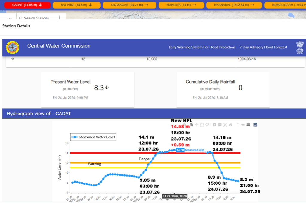
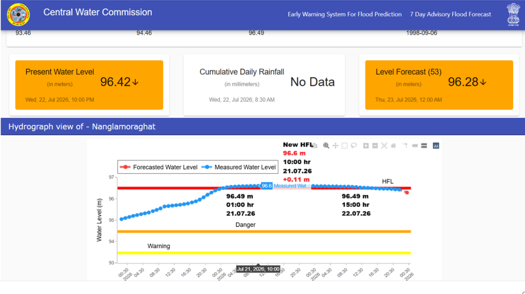
After 32 years, river Ambika at Gadat site in Surat, Gujarat has crossed it HFL 13.985 meter (16.06.1994) at 12:00 hour on 23.07.2026. The flood level in the river has increased by 9.45 meter in 3 days (72 hours) from 5.13 meter on 21:00 hour on 20.07.2026 to 14.58 meter at 19:00 hour on 23.7.2026.
River Desang in Brahmaputra basin at Nanglamoraghat site in Sivsagar district of Assam has crossed its HFL 96.49 meter dated 06.09.1998 at 01:00 hour on 21.07.2026. Present flood level is 49.96 meter and forecasted to come down to 96.58 meter at 12:00 hour.
URBAN FLOODS
IMD Data Blames Local Rainfall for Guwahati Floods The report mentions that IMD data challenged the long-held claim that heavy rainfall in neighbouring Meghalaya is the primary cause of flooding in Guwahati. During the July 24 deluge, the IMD station at Umtrewdam in Meghalaya’s Ri Bhoi district recorded only 18 mm of rainfall, while parts of Guwahati experienced intense, highly localized downpours. Areas including Khanapara, Sarusajai and Kalakshetra received nearly 90 mm of rainfall within two to three hours, with several other parts of the city recording 60–70 mm, whereas Borjhar received just 9 mm during the same period.
The report said the rainfall pattern indicates that the recent flooding was driven largely by extreme rainfall within Guwahati itself, exposing shortcomings in the city’s urban planning, drainage infrastructure and flood management rather than upstream runoff from Meghalaya.
Srinagar Flooding Exposes Governance Failures In an article published on July 22, 2026, Dr. Fiaz Maqbool Fazili argued that the flooding caused by just two hours of rainfall on July 20 exposed serious shortcomings in Srinagar’s urban governance rather than being merely an engineering failure. He highlighted how inundated roads, submerged hospitals and disrupted emergency services revealed deficiencies in stormwater drainage design, poor maintenance, inadequate engineering supervision, blocked drains, weak inter-departmental coordination and unchecked solid waste disposal.
CLOUD BURSTS
July Rain Fury Kills 28 in J&K During the first three weeks of July 2026, Jammu & Kashmir witnessed one of its worst monsoon-related disasters in recent years, as repeated cloudbursts, flash floods and landslides claimed at least 28 lives and caused widespread destruction across the Union Territory. The disasters severely damaged roads, bridges, power infrastructure, drinking water supply schemes, agricultural land and residential areas, while several people were injured and rescue teams conducted evacuation and relief operations in multiple districts. Meteorological officials reported 15–16 cloudbursts during the first half of July alone, with continued heavy rainfall triggering additional flash floods and landslides in the following days, underscoring the growing impact of extreme weather in the Himalayan region.
J&K Records Over 20 Cloudbursts in 20 Days On July 21, 2026, reports indicated that Jammu & Kashmir had experienced more than 20 cloudbursts during the first 20 days of July 2026, triggering widespread flash floods, landslides and mudslides across the Union Territory. The worst-affected areas included Gurez and Tulail Valley in north Kashmir, Thathri and Bhalesa in Doda district, Chasoti in Kishtwar, Kathua, and the Pir Panjal districts of Poonch and Rajouri. The disasters caused multiple fatalities, left several people missing, damaged over 100 houses, washed away bridges and disrupted roads, including stretches of the Jammu–Pathankot National Highway.
J&K Sees 15 Cloudbursts in Two Weeks On July 14, 2026, reports said Jammu & Kashmir recorded at least 15 cloudburst incidents during the first 14 days of July, triggering flash floods, mudslides and landslides across several districts. The extreme weather damaged roads, bridges, public infrastructure, agricultural land and residential properties, while disrupting road connectivity and normal life. Major incidents included Bhalesa and Thathri (Doda district), where flash floods blocked roads, damaged shops and vehicles, and disrupted traffic on the Doda–Kishtwar National Highway. Earlier, Gurez and Tulail Valley witnessed multiple cloudbursts damaging roads and bridges, while two cloudbursts in Awoora and Dehwathu (Anantnag) on July 11 caused flash floods that inundated parts of Pahalgam, including several hotels. The report highlighted scientific studies linking the increasing frequency of cloudbursts in the western Himalayas to climate change and called for improved hazard mapping, weather monitoring, land-use planning and early warning systems.
Will We Listen Before The Next Cloudburst Strikes? The recent cloudburst disasters should serve as a wake-up call for adopting a new development paradigm in the Himalayas. Citizens must recognise that rivers, streams, wetlands and floodplains are not vacant land awaiting development but essential components of Kashmir’s natural safety system. Preventing encroachments, protecting forests and wetlands, and maintaining local drainage channels are shared responsibilities. The mountains are sending increasingly frequent warnings—whether these hazards become disasters depends largely on the choices we make today. (Pir Rayees Ahmad, Senior Scientist (Hydrogeologist) CGWB)
Boniyar Cloudburst Disrupts Roads and Water Supply A cloudburst struck the upper reaches of Mayan village in Boniyar tehsil, Baramulla district, Jammu & Kashmir, on July 23, 2026, triggering flash floods that washed away four culverts, disrupted road connectivity, and severely affected electricity and drinking water supply. The floods damaged the Neela Nag water source and raw water transmission pipelines, interrupting water supply to several villages. During the emergency, a woman trapped in her house in the Lachipora–Bijhama area was safely rescued by the Jammu & Kashmir Police and civil administration. Restoration work on roads, power, and water infrastructure was launched, while authorities advised residents to remain alert and avoid flood-prone areas.
Following the cloudburst, vulnerable residents were asked to immediately shift to safer places as a precautionary measure. Authorities in Baramulla on July 23 rescued a woman who was trapped inside her house following a cloudburst in the Mayan area of Lachipora, Bijhama. The biggest concern is that debris brought down by the cloudburst has completely blocked the main stream. As a result, water is accumulating near the culvert, leading to waterlogging in the area. If the blockage is not cleared immediately, the accumulated water could overflow into nearby residential areas, causing even greater damage. Local residents are therefore demanding the immediate deployment of earth-moving equipment and heavy excavators (JCBs) to remove the debris and restore the stream’s flow as quickly as possible.
Beerwah Flash Flood Kills One, Damages Infrastructure On July 21, 2026, flash floods triggered by intense rainfall in the upper catchment of the Sukhnag River swept through Beerwah and adjoining areas in Budgam district, Jammu & Kashmir, killing one person. The victim, Shabir Ahmad Poswal of Drang in Khag, was swept away while attempting to cross a flooded nallah. Heavy rainfall, exceeding 100 mm in the TosaMaidan catchment, caused a sudden surge in the Sukhnag River, inundating residential and commercial areas. The floods damaged several shops, including the Municipal Shopping Complex near the Beerwah bus stand, breached embankments, washed away the Sukhnag diversion, and damaged a newly constructed bridge. Officials said the rapid rise in water level indicated a possible cloudburst or highly localized extreme rainfall event, and damage assessment was underway.
Cloudburst Triggers Flash Flood Threat in Uri On the afternoon of July 24, 2026, a cloudburst struck Maya village in the Uri sector of Baramulla district, Jammu & Kashmir, causing a sudden rise in the water level of the Maya stream and triggering a flash flood threat. As a precaution, the administration evacuated residents from vulnerable areas to safer locations with assistance from the J&K Police, tehsil administration, Army and Health Department. Emergency teams monitored the situation, while police used public address systems to warn people living near the stream. No loss of life, injuries or property damage was reported, and the water level began receding after the initial surge. Authorities advised residents to remain alert as intermittent rainfall continued across the region.
Flash Floods Displace Families in Udhampur During the early hours of July 25, 2026, flash floods, suspected to have been triggered by a cloudburst, struck the Barkuanda area of Bupp in Udhampur district, Jammu & Kashmir. The floods affected several households, prompting the local administration to evacuate three families as a precaution and relocate them to the Government Middle School, Barkuanda, where temporary shelter arrangements were made. No casualties were reported. The administration has initiated an assessment of the damage caused by the flash floods and continues to monitor the situation in the affected area.
Four Cloudbursts Trigger Floods in Gurez and Budgam On July 22, 2026, four cloudbursts struck the Gurez–Tulail region of Bandipora district amid incessant heavy rainfall in Jammu & Kashmir, triggering flash floods, landslides and widespread disruption. In Budgam, flooding in the Sukhnag Nallah washed away several shops, while waterlogging inundated residential areas and markets in Srinagar and other urban centres. The cloudbursts disrupted road connectivity in Gurez, damaged BSNL telecom towers, and landslides blocked two roads. Owing to the continuing severe weather, the government extended the closure of all schools across the Union Territory until July 26, 2026. Heavy rainfall also affected the Poonch–Jammu Highway and temporarily disrupted the Amarnath and Vaishno Devi pilgrimages.
Cloudbursts Cause Heavy Damage in Gurez–Tulail On July 22, 2026, persistent heavy rainfall for the third consecutive day triggered four cloudbursts in the Gurez–Tulail region of Bandipora district, causing flash floods, landslides and widespread damage. One cloudburst occurred in Chorwan and three in Tulail, damaging agricultural land, affecting BSNL telecom towers, disrupting road connectivity and blocking two roads, one of which was later reopened. In Budgam, the Sukhnag Nallah rose to its highest level since the 2014 floods, submerging the Beerwah diversion and halting traffic, while authorities warned that rising water levels could inundate low-lying villages. In Srinagar, heavy rain caused extensive waterlogging, flooding roads, residential areas and markets, with several shops suffering damage. District authorities launched restoration works, implemented safety protocols along the Kishanganga River for tourists, and advised residents and visitors to avoid vulnerable areas and monitor weather advisories.
Cloudbursts Trigger Flash Floods Across J&K On July 19, 2026, multiple cloudbursts triggered flash floods in Kishtwar, Daksum in Anantnag district, and Dawar in Gurez Valley, Bandipora district, amid heavy rainfall across Jammu & Kashmir. In Kishtwar, flash floods damaged roads, disrupted connectivity and deposited debris, prompting restoration and assessment by district authorities. In Daksum, a sudden surge in local streams damaged infrastructure and disrupted movement, while residents near water channels were advised to remain alert. In Dawar, Gurez, a cloudburst damaged a cowshed, trapped two cattle and household belongings, washed away part of a link road, and stranded residents on either side of the damaged stretch. The Border Roads Organisation (BRO) and Jammu & Kashmir Police launched restoration work. No casualties were reported. Authorities maintained a high alert as continued rainfall kept rivers and streams swollen, highlighting the region’s increasing vulnerability to extreme weather events.
Cloudburst Damages Road and Cowshed in Gurez On the morning of July 19, 2026, a cloudburst struck Dawar in the Gurez area of Bandipora district, Jammu & Kashmir, triggering a flash flood that caused a sudden rise in the water level of a local nallah. The flood damaged a cowshed, trapping two cows and household belongings, and washed away a section of the link road connecting Dawar with the Mousum area, disrupting local connectivity and leaving several people stranded on either side of the road. Personnel from the Jammu & Kashmir Police and the Border Roads Organisation (BRO) launched restoration work to clear debris and restore access. No casualties or injuries were reported, and authorities advised residents to avoid overflowing streams and vulnerable areas until weather conditions improved.
Cloudburst and Landslide Kill Seven in Poonch On July 20, 2026, heavy overnight rainfall and a cloudburst triggered a major landslide in Loran village of Poonch district, Jammu & Kashmir, burying a mud house and killing seven members of a family, including four women. Rescue operations were launched to recover victims from the debris. Earlier on Sunday morning, cloudbursts in Bafliaz and other parts of Surankote tehsil triggered flash floods, causing widespread destruction across the area. The report also noted that severe rainfall had claimed lives in Rajouri district, while a separate landslide on the Batote–Kishtwar National Highway in Doda district killed two people and injured five others after vehicles waiting on the highway were struck by falling boulders.
Search Continues for Missing Victims After Surankote Flash Floods Rescue teams continued searching for eight people missing after devastating flash floods triggered by cloudbursts in the Surankote area of Poonch district, Jammu & Kashmir, with no bodies recovered for the third consecutive day. Heavy rainfall also caused widespread disruption across the Jammu region, triggering landslides that blocked the Jammu–Poonch National Highway for several hours and washing away sections of the Old Samba–Kathua road. In Poonch district, flash floods damaged electricity poles, transmission towers, and transformers, leaving large areas without power and disrupting drinking water supply to Poonch town, Mandi, Mendhar, Surankote, and surrounding areas since 19 July. The incident highlights the severe impacts of extreme rainfall on transport infrastructure, power supply, and essential services in the Pir Panjal region.
Cloudburst and Flash Floods Hit Ganderbal and Kargil On July 20, 2026, a cloudburst struck Sheikh Mohalla in Safapora, Ganderbal district, sending torrents of water and debris into residential areas, disrupting normal life and damaging local property. On the same day, flash floods caused widespread destruction in Kargil, damaging several houses, agricultural land, orchards and fields, while uprooting numerous trees. The floods severely affected farming communities, threatening livelihoods by destroying crops and cultivable land. The administration and relief agencies began damage assessment and initiated relief measures to support affected families and restore damaged infrastructure.
Officials said that continuous cloudbursts on July 20 evening in Jedgai and Achhura villages of the Gurez and Tulail valleys in Bandipora district triggered flash floods. The floods, carrying trees and boulders, caused significant damage to several houses and standing crops.
In addition, flooding in the Kariki Chu and Badgam areas of Kargil also damaged residential properties, vehicles, and agricultural crops. However, no casualties have been reported from these areas. As the Kishanganga River water level rose, the administration directed tourists and owners of tent colonies to vacate areas along the riverbank as a precautionary measure.
A cloudburst hit the Chittergul area of Anantnag on July 12, triggering severe flash floods that wreaked havoc on the region. Agricultural fields and residential homes suffered extensive damage, with reports of water flooding homes and obliterating crops and trees. Numerous families were forced to evacuate as the waters rose. The local administration is now assessing the destruction and coordinating relief support for affected residents.
Cloudbursts Trigger Flash Floods Across J&K On July 2, 2026, an active western disturbance triggered cloudbursts, flash floods and landslides across parts of Jammu & Kashmir. In Tulail Valley of Gurez (Bandipora district) and Kalaroos and Lolab areas of Kupwara district, cloudbursts caused flash floods that inundated houses, damaged standing crops, washed away roads and temporarily disrupted connectivity. Earlier, successive cloudbursts also struck Kalalgisar and Seru villages in the Bhalessa region of Doda district, where flash floods deposited debris on roads, cut off access to several villages and heightened the risk of further landslides. Authorities continued monitoring the situation as the IMD warned of more heavy rain and thunderstorms.
Monsoon Triggers Flash Floods and Cloudbursts in J&K On July 1, 2026, the first major spell of the southwest monsoon triggered flash floods and cloudbursts across parts of Jammu & Kashmir. In Guridraman village, Larnoo (Anantnag district), a flash flood followed heavy afternoon rain, prompting villagers to safely evacuate students from a local school before police, SDRF and civil administration teams reached the site.
In Tulail Valley, Gurez (Bandipora district), a cloudburst over Zadigay Nallah damaged the Kilshay–Zadigay road, disrupted connectivity and caused a sharp rise in the Kishanganga Nallah. Meanwhile, two cloudbursts struck Kalalgisar village in Bhalessa, Doda district, following intense rainfall. No casualties were reported, but authorities monitored the affected areas and warned of further heavy rainfall and possible weather-related incidents.
On July 1, 2026, a cloudburst near Zadigey Nallah in the Tulail Valley of Gurez, Bandipora district, Jammu & Kashmir, triggered a sudden flash flood. The flood caused extensive damage to the Kilshey–Zadigey road and led to a rapid rise in the water level of the Kishanganga Nallah.
Cloudburst Causes Flash Floods in Tulail Valley On June 17, 2026, a cloudburst struck Tartei Kilo village in Tulail Valley, Bandipora district, near the Line of Control, triggering flash floods that sent torrential rain and debris-laden waters through the area. The flood damaged several residential houses and submerged large stretches of agricultural land, though no loss of life was reported. The report noted that this was the fifth cloudburst in Jammu & Kashmir within a few days, following four cloudbursts on June 16 in Doda, Kishtwar and Poonch districts, which caused flash floods, inundated houses, and blocked roads but did not result in casualties.
Cloudbursts Trigger Deadly Floods Across J&K and Himalayas On July 20, 2026, heavy rainfall since Saturday night and six cloudbursts caused widespread flash floods, landslides and infrastructure damage across Jammu & Kashmir, with Rajouri and Poonch emerging as the worst-hit districts. The disasters claimed 12 lives, left around 12 people missing, swept away several vehicles, damaged hundreds of government buildings, shops and houses, and washed away roads, cutting off connectivity to several district headquarters. In Kargil, Ladakh, a cloudburst triggered flash floods that deposited debris on roads, damaged sections of the Kargil–Zanskar National Highway (NH-301), and affected private property and livestock. In Pangi subdivision of Chamba district, Himachal Pradesh, a cloudburst around 9:30 AM damaged cash and seasonal crops, while landslides blocked roads, including the Chamba–Bharmour National Highway, disrupting connectivity.
Himachal Pradesh Cloudburst Damages Homes in Kangra Valley On July 22, 2026, a cloudburst in the upper reaches of Boh Valley in Shahpur subdivision of Kangra district, Himachal Pradesh, triggered flash floods and landslides, injuring three people and damaging 18 houses in Speda and Garghoon villages. The floods also destroyed nine cowsheds, killed eight cattle, and damaged a primary school building. No fatalities were reported. Rescue teams from the National Disaster Response Force (NDRF) and State Disaster Response Force (SDRF) were deployed, while the district administration shifted affected families to temporary shelters and initiated a damage assessment. Officials also identified Lam village as being at risk from the continuing heavy rainfall.
A cloudburst has caused massive devastation in the Garhgun and Spada villages of the Boh Valley in Kangra district. Twenty-five houses were completely destroyed in the disaster, while many others sustained damage. The Deputy Commissioner reported that a total of 38 families-comprising approximately 200 people-have been affected. In Garhgun village, 12 families lost their homes entirely, while 13 houses were completely destroyed in Spada village. Additionally, nine houses were partially damaged, and 12 others remain at risk. Several cowsheds were buried under debris, resulting in the loss of livestock. Household belongings, rations, and clothing belonging to the affected families were also buried in the debris.
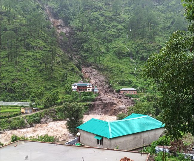
Local residents reported hearing a loud explosion-like sound from the hills, and within moments, a torrent of water, mud, and large boulders rushed downhill. Officials said that landslides also occurred in the Dibba and Maned Nala areas, making it difficult for rescue teams and administrative officials to reach the disaster-affected locations.
It is reported that residents ran for safety to save their lives. After a loud explosive-like sound was heard from the hillside, a sudden flash flood carrying debris rushed down, sweeping away houses and cattle sheds. The flood has left local residents frightened. Families living in houses close to the hillside have evacuated their homes and are staying outside, as they are too afraid to return due to fears of further landslides and flooding.
A woman named Rano Devi saved the lives of residents in Garghoon village, Boh Valley, by recognizing the early signs of an impending flash flood. Noticing the stream suddenly turning muddy, she recalled the devastating 2022 cloudburst that killed 10 people and immediately ran through the village warning everyone to evacuate. Minutes later, a massive torrent of water and debris swept away houses, cattle sheds, livestock, and buried agricultural fields. Although many homes were destroyed, residents credit her timely warning with saving the lives of people from around 12 households.
Cloudbursts Trigger Flash Floods Across Himachal Heavy rainfall triggered multiple cloudbursts and flash floods across Himachal Pradesh on July 20, 2026. Around 5:50 PM, a cloudburst near Shalkhar in Kinnaur district caused a flash flood that blocked the Kinnaur–Spiti road, halting traffic while the Border Roads Organisation (BRO) began restoration work. In Lahaul-Spiti, rising water levels in the Chandrabhaga River overflowed the Jobrang Bridge, while a flash flood washed away the temporary crossing over the Jahalma Nallah, disrupting local transport. In Pangi Valley, Chamba district, a cloudburst at Udin Nallah damaged access routes, leaving about 20 workers stranded across the ravine before they were safely rescued. Authorities advised the public to avoid affected routes until restoration work is completed.
Flash flood in Purthi nallah in Chamba on July 23, 2026.
Flash Flood Threatens Nyangal Village Homes On July 21, 2026, flash floods caused by the diversion of a seasonal stream following a landslide devastated Nyangal village in the Kotla area of Kangra district, Himachal Pradesh. Floodwaters entered residential areas and farmlands, leaving 15 houses under threat and washing away agricultural fields. Residents said the village had suffered a similar disaster two years earlier when a hillside collapsed, damaging several homes. They alleged that despite repeated appeals, no permanent protective measures had been taken and urged the government to construct a retaining wall to restore the stream’s course and prevent future flooding.
Cloudburst Washes Away Temporary Bridge in Lahaul A cloudburst in Mayar Valley of Lahaul-Spiti district, Himachal Pradesh, triggered flash floods that washed away the temporary bridge over Dhondhal Nala, severely disrupting connectivity for local residents. Although the road was later restored, vehicles were forced to cross the stream through flowing water, posing significant safety risks. The Public Works Department deployed machinery at the site and installed a temporary ropeway to facilitate movement. Local MLA Anuradha Rana said that eight to ten temporary and permanent bridges have been washed away at Dhondhal Nala over the years, while repeated flash floods since June 2026 have continued to affect streams across the valley. She said construction of a permanent bridge at the site is expected to begin this year.
Cloudburst Washes Away Three Bridges in Lahaul On August 13, 2025 also, authorities reported that a series of cloudbursts around 7:00 PM the previous evening triggered flash floods across Mayar Valley in Lahaul-Spiti district, Himachal Pradesh. The floods washed away three bridges over the Karpat, Changut and Udgos nallas, while the main bridge over the Mayar Nala was submerged. The disaster disrupted connectivity for six villages, damaged houses located along the streams, affected mobile communication, and caused extensive losses to agricultural fields and standing crops. Residents fled their homes to safety, and the administration launched relief operations and began assessing the damage.
Cloudburst Traps Three Workers in Chamba On July 21, 2026, a cloudburst in Kalah Nallah in the Holi area of Bharmour, Chamba district, Himachal Pradesh, triggered a sudden flash flood that rapidly raised the water level in the stream. Three workers engaged in work along the nallah were stranded in the middle of the stream as the strong current prevented them from reaching safety. Local residents rushed to the site and monitored the situation. After the water level receded, the workers were safely rescued without any injuries or casualties.
Pangi Cloudburst Strands 20 Workers A cloudburst struck Udin Nallah and Hillu Nallah in Pangi Valley, Chamba district, Himachal Pradesh, on the afternoon of July 20, 2026, triggering flash floods that brought water and debris onto roads. The floods blocked the main link road connecting Udin and Hillu villages, damaged several road sections, and disrupted transport. Around 20 workers engaged under the VB-G RAM G project were stranded by the sudden flooding but were safely rescued by local residents during a prompt rescue operation, preventing any casualties.
Cloudburst Triggers Flash Flood in Chamba On July 21, 2026, a cloudburst triggered flash floods in Pangi Valley of Chamba district, Himachal Pradesh, disrupting normal life and causing panic in the area. Several workers were stranded by the sudden floodwaters but were rescued safely by authorities. No casualties were reported. Officials continued to monitor the situation as the flash floods affected local movement and raised concerns over further weather-related risks.
Mandi: Cloudburst on July 25 in Odhadhara of Rains Panchayat Triggers Flash Flood in Rainsnallah.
LANDSLIDES LAKE
9 Killed in Rain-Triggered Landslides Across Nagaland At least nine people were killed and five injured after intense rainfall triggered landslides at multiple locations in Mon district, Nagaland. According to the Nagaland State Disaster Management Authority (NSDMA), the disaster affected more than 10 locations, forcing the establishment of temporary relief camps while many displaced families took shelter with relatives. The IMD reported 137 mm of rainfall in Mon district, attributing the extreme weather to an upper cyclonic circulation over central Assam and adjoining Nagaland.
ENVIRONMENT GOVERNANCE
SC Panel Invites Public Suggestions for Aravali Protection A Supreme Court-appointed high-powered committee has invited public suggestions, representations and documentary evidence on the protection of the Aravali hills, with its report due to the Supreme Court by 31 August 2026. The Union Environment Ministry has asked stakeholders from Haryana, Rajasthan, Delhi, Gujarat and other Aravali states to submit inputs within 21 days through email or a dedicated portal.
The committee’s recommendations are expected to shape future legal and policy measures for conserving the 700-km-long mountain range, which faces increasing threats from mining, urbanisation, infrastructure projects and encroachments.
NGT Rebukes MoEF&CC Over Raisina Aravalis Case The NGT has reprimanded the Ministry of Environment, Forest and Climate Change (MoEF&CC) for failing to appear in proceedings concerning environmental violations in the ecologically sensitive Raisina Aravalis despite being served notice. The Tribunal directed the Ministry to appear at the next hearing or appoint legal representation and file its response to an intervention application within two weeks.
A forest department survey has identified at least 500 illegal farmhouses in Gurugram’s Aravali region, while environmentalists have criticised delays in enforcement, noting that construction has continued despite repeated tribunal directives. The next hearing is scheduled for 1 September 2026.
Abandoned Coal Mines Leave Jharkhand Communities at Risk An investigative report by Tapasya reveals that abandoned coal mines in Jharkhand, particularly in Dhanbad’s Jharia coalfields, continue to pose severe risks despite government commitments to scientific mine closure. Toxic gas leaks, land subsidence, underground fires, and unsafe abandoned mines have caused at least 20 deaths in seven incidents over the past year, while affected communities remain exposed to long-term environmental and health hazards. The report highlights that closure plans for 147 mines overlook community rehabilitation and socio-economic impacts, with many mines left unsealed due to commercial interests. Residents complain of inadequate compensation, poor rehabilitation, lack of consultation, and continuing threats from gas emissions and collapsing ground.
SANDRP
Also see: DRP 20 July 2026 & DRP 13 July 2026
Follow us on: www.facebook.com/sandrp.in; https://twitter.com/Indian_Rivers


