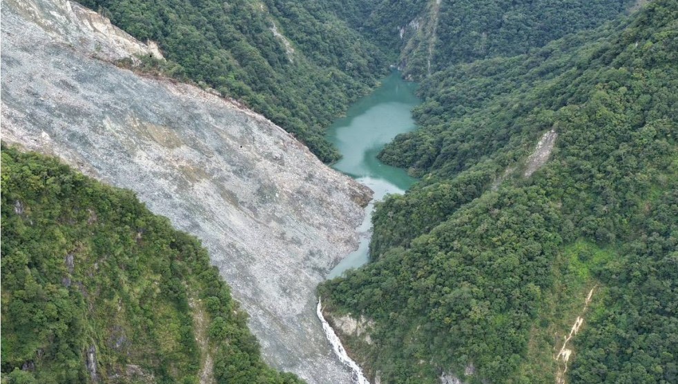
(Feature Image: Aerial image of the Wanlixi landslide and lake as of 30 July 2026. Credit: Forestry & Nature Conservation Agency, Taiwan, Source: EOS.Org)
While writing about the landslide dam breach in Taiwan last year leading to 24 deaths, Dave Petley remarked: As always, the focus should be on vulnerability and resilience rather than only early warning systems (EWS). This is indeed worth emphasizing, underlining, highlighting. While early warning systems can be important and must be used wherever possible, it is not a magic bullet. It is one of the many other instruments in disaster management.
As Petley said, focus should always be on vulnerability and resilience, both inherent and man-made. If we do not focus on these factors, EWS won’t be helpful. As Petley writes, Taiwan case was one with a known hazard, a fully understood trigger event (the typhoon) and a very well-developed emergency management system, but that did not stop serious losses. Operating a system that is providing surveillance over a massively larger area for an event that might have no clearly defined trigger; with the flood impacting a much greater distance; and in a country with lower development of its emergency management system, is no guarantee for preventing disaster or losses. If the development process in such a place is built to reduce vulnerability and increase resilience, it would help much more than EWS.
Even in cases where EWS is in place and it works, if the disaster management system (DMS) is not able to use that information provided by a formal EWS, EWS won’t help. This was indeed the situation in Uttarakhand in June 2013 and Sikkim in Oct 2023, among others. And sometimes even informal EWS can save numerous lives as was seen in case of a village woman’s early action saved 15-20 lives in Chamoli in Feb 2021. An alert DMS can use information from formal or informal EWS and save lives and losses, while a lethargic, unprepared and unaccountable DMS won’t be able to use the information and EWS won’t help, formal or informal.
Taiwan Breach of a Landslide dam killed 24 people in Sept 2025 According to a new blog by Dave Petley on Sept 24, 2026, on 23 September 2025, a large landslide dam (located at [23.715, 121.299]) on the Matai’an River in Hualien County in Taiwan catastrophically breached, releasing a flood that left 24 people killed or missing, with a further 156 people injured. A new, open access paper has been published in the journal Landslides (He et al. 2026) that describes both the landslide and the resultant flood.
The main failure that generated this landslide occurred during Tropical Storm Wipha, which brought 573 mm of rainfall in three days (this is not a particularly exceptional level of rainfall for Taiwan). The landslide on the Matai’an River was very large – He et al. (2025) have calculated the voume as 285.90 million m3, forming a dam in the valley below that was 200 m high. The analysis by He et al. (2025) suggests that the breach generated two peak flow events. The first occurred 15:38 on 23 September 2025, reaching 6,612 m3, followed by a second, larger peak flow at at 16:24 at 9,309 m3. This is a massive flood event for a catchment of this scale.
Even in a scenario with a known hazard, a fully understood trigger event (the typhoon) and a very well-developed emergency management system, losses still occur. Operating a system that is providing surveillance over a massively larger area for an event that might have no clearly defined trigger; with the flood impacting a much greater distance; and in a country with lower development of its emergency management system, is infinitely harder. As always, the focus should be on vulnerability and resilience rather than on magic bullet called early warning systems.
HYDRO POWER PROJECTS
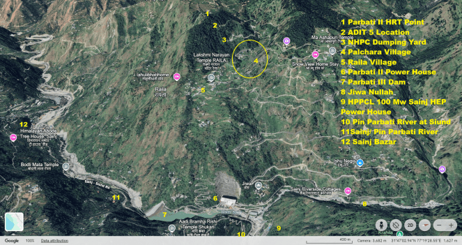
Sept. 2026: NHPC’s Parbati-II HEP Tunnel Leakage in Himachal Given the repeated tunnel leakage and seepage incidents over the years, the project indeed requires an independent technical and geological investigation by experts who are not associated with NHPC or the project. The investigation should examine the cumulative safety record of the project, the causes and consequences of earlier incidents, the adequacy of repairs and maintenance and the safety of downstream settlements. This is particularly important in view of concerns raised over NHPC’s record of accountability and transparency in responding to project-related incidents and public concerns. The findings should be made public along with clear recommendations and a time-bound action plan to prevent recurrence in future.
Uttarakhand invokes force Majure clause due to lower hydro generation even during monsoon In an unprecedented move, Uttarakhand Power Corporation Ltd (UPCL) invoked force majeure and imposed power cuts ranging from 35 minutes to 15 hours after deficient monsoon rainfall reduced river flows and hydropower generation. Heavy industries in Kumaon and Garhwal faced the longest outages on Sept 21-22, while Haldwani recorded the shortest cut of 35 minutes. Last Sept, UJVNL generation during peak hours was 1,094MW, which has come down to 912MW this year.
Landowners in 7 villages reject NEEPCO’s Naying HEP The landowners in 7 villages of Shi Yomi and West Siang districts in Arunachal Pradesh on Sept 23 2026 rejected NEEPCO’s 1000 MW Naying HEP on Siyom River.
Adi Body urges Arunachal Govt to Scrap SUMP The Adi Bane Kebang-United (the apex body of Adi community) has on Sept 22 2026 urged Arunachal Pradesh to immediately scrap the proposed 11000 MW Siang Upper Multipurpose Project, citing concerns about displacement, ecology, ancestral and cultural aspects. The consultative meeting of the Adi community held at Geku on Sept 16 adopted a four point resolution. The resolution demanded scrapping of the project, cancellation of the agreements for Pre-Feasibility Report, withdrawal of the security forces and reinstatements of the village heads removed for opposing the project.
CM orders action against officials opposing SUMP CM Pema Khandu on Sep 21 has directed the Chief Secretary to take action against govt employees and officials allegedly attempting to create disturbances or oppose the project. Khandu said the govt would intensify its awareness efforts and that he would soon visit Siang and Upper Siang to interact with local employees and residents. On the deployment of security forces in Siang and Upper Siang amid the ongoing row, Khandu said the people of the region, as owners of the land, had to be taken on board.
SUMP: State Vs Indigenous people Once again, the Siang valley, particularly Upper Siang and Siang, has flared up as the administration and the indigenous Adi community have come face to face over sharply differing positions. The community is opposing the pre-feasibility report (PFR) activities for the proposed Siang Upper Multipurpose Project (SUMP), pegged between 11,000 mw and 12,500 mw. The state’s refusal to acknowledge the people who are fighting to save their land, and to take their fear and apprehension into account, continues while the state weaves a narrative in the name of countering a powerful neighbour’s attempt to control the river, flood control, strategic interests, and national security. The author also provides timeline of the Siang proposals and changing statements of the politicians. (Tongam Rina)
Submerging dissent True development cannot be coerced at gunpoint or secured through administrative silencing. If mega-dams are to be justified in the national interest, the state must first prove its case to the people whose land and lives hang in the balance. Drop the punitive cases against community leaders, withdraw paramilitary garrisons from the villages, and recognize that indigenous voices have an equal, inviolable right to determine the future of their own homeland. (Lohit Sharma)
The National Alliance of People’s Movements (NAPM), National Alliance for Climate and Ecological Justice (NACEJ) and All-India Rivers’ Forum (AIRF) have demanded: An immediate end to all oppressive measures against the local communities, SIFF, Bhanu Tatak, Ebo Mili and other community leaders and activists, including by misuse of the FCRA law against Bhanu Tatak.
Immediate withdrawal of all armed forces / military personnel from the indigenous villages, de-militarization and restoration of space for democratic participation by communities in Government decisions that affect their livelihoods, ecology and futures. Free, fair and transparent public consultations at the village level must be held in the presence of neutral observers. Revocation of all clearances and permissions granted to the hydro-electric and power projects in the region, in violation of law and democratic processes.
Can Himalayan rivers withstand more infrastructure? As Himalayan dams multiply, rising climate and geological risks are exposing the limits of assessing projects one at a time. Experts believe it is important to examine the larger impact of infrastructure on a mountain system.
DAM SAFETY
Jharkhand to set up expert panels for safety review of 59 key dams The Jharkhand water resources department has initiated the official process to establish two Independent Panels of Experts (IPoE) for conducting a comprehensive dam safety evaluation of 59 key dams situated across the state under the department’s direct jurisdiction. Each panel will feature a multidisciplinary team of eight domain specialists. The panel composition includes dedicated experts in dam safety, structural design, construction supervision, geology, hydrology, hydromechanics, instrumentation, and seismology. A chairperson, chosen directly from among the appointed members, will lead each respective panel.
Moti Lal Pingua, engineer-in-chief of the department, confirmed that the panels are being constituted under the mandate of Section 38 of the Dam Safety Act, 2021. “The panels will be formally set up and the on-ground work for the dam safety evaluation will commence within the next three months in strict accordance with the provisions and guidelines of the Act,” he said.
Telangana: KLIS rehabilitation from mid-Nov, monsoon 2027 deadline Irrigation Minister N Uttam Kumar Reddy said the government had finalised the designs to restore the safety and operational reliability of all three barrages. The rehabilitation plan has been drawn up taking into account concerns raised by the National Dam Safety Authority and other expert bodies over the safety of the barrages, Uttam said. The designs are now being validated through computational fluid dynamics modelling at the Central Water and Power Research Station, Pune. The designs will be placed before the Technical Oversight Committee under the Central Water Commission in New Delhi on October 5 for expert examination and recommendations.
Challenge to Ranjit Sagar Dam Safety The major concern is that during dry season, water levels in reservoir drop to the lowest point, hampering power generation and reducing dam’s efficiency. In contrast, the rainy season brings excess inflow to the reservoir, often surpassing the reservoir’s maximum capacity and triggering downstream flooding, consequently has adverse impact on socio-economic well-being of downstream communities. The research also warns of additional risks to dam safety, including erosion of sedimentary rock formations, the dam’s location in a tectonically active zone with presence of strike-slip fault, high seismic activity, and the threat of landslides which may aggravate the risks to dam safety. These findings underscore the urgent need for stronger safety measures and sustainable management practices to protect both communities and infrastructure. (Nidhi Jasrotia)
DAMS
Dodhan dam project oustees protest The agitation by people affected by the Majhgawan dam project in Madhya Pradesh’s Panna district entered its 16th day on Sept. 27, as the protesters staged a ‘satyagraha’ despite rain and waterlogging. Several houses in villages affected by the project have been inundated, with two to three feet of water entering some homes and damaging grain, clothes, and household articles, the protesters claimed.
Maharashtra: Poshir dam project sparks protest The proposed Poshir dam in Raigad’s Karjat taluka will alter that landscape, submerge more than 2000 acres of biodiversity-rich forest land and displace tribal community members. The survey for the Poshir dam has been set in motion as a result of the state government’s plans to meet the growing water requirements of Mumbai, Thane and Navi Mumbai. The project will require acquisition of 5,416 acres, including around 2,400 acres of forest land and 3,017 acres of private land, according to project-related details shared by a local activist. Villagers and environmental groups fear the loss of forest, wildlife habitat, agricultural land and homes.
Local people are opposing the Kishau Dam project raising concerns over its impacts on villages, livelihoods.
Siltation in Hirakud Dam The Odisha CM, who also holds water resources portfolio, said in the assembly that Hirakud dam had 1.82 MAF (Million Acre Feet) silt by 2000. Initially in 1957, the dam’s dead storage, live storage and total storage capacities were 1.88 MAF, 4.72 MAF and 6.60 MAF, respectively. The 2000 assessment estimated the reservoir’s dead storage, live storage and total storage capacities at 0.87 million acre-feet, 3.91 million acre-feet and 4.78 million acre-feet, respectively. The figures show that the dead storage capacity has declined by 1.01 million acre-feet, while the live storage capacity has fallen by 0.81 million acre-feet.
INTERSTATE WATER DISPUTES
Karnataka agrees to release Krishna water for Jurala Project Telangana Irrigation officials on Sept 23 2026 morning released water from the Jurala project for farmers after Karnataka DM DK Shivakumar assured the Telangana government on Sept 22 night that Karnataka would release water from the Krishna River. A delegation of Telangana Ministers on Tuesday met DK Shivakumar and requested him to release Krishna water (from Narayanpur project) to Telangana to protect standing crops in the erstwhile Mahabubnagar district.
The Telangana delegation requested Karnataka to release 5,000 cusecs of water per day continuously for 30 days so that the Telangana government could protect standing crops across 5.5 lakh acres under Jurala, Bhima, Nettempadu and Koilsagar projects.
IRRIGATION
No progress on Peddavagu project revival after 2 years It has been close to two years since the Peddavagu project, a joint irrigation project located on the border of Telangana and Andhra Pradesh, remained defunct after it was breached in July 2024, yet there are no signs of its revival. The governments of both the States are yet to come to an understanding on rebuilding the medium irrigation project at Gummadavalli in Aswaraopet mandal in the district, as it is assumed that carrying out repairs would yield no result.
Private firm damages Chola-Era dam in Coimbatore Environmental activists have urged the immediate cancellation of the contract awarded to a private company to dredge the 800-year-old Chola-era check dam built on the Noyyal River in Tamil Nadu’s Coimbatore. While dredging the Kuniyamuthur check dam near Perur, the private firm broke down and removed the old check dam. After learning about this, environmental activists went to the area and argued with the representatives of the organisation. Following this, allegations have also been raised that the stones taken from the breach of the check dam were hastily buried in river soil and covered.
URBAN RIVERS
Pollution reshapes Mula-Mutha river life despite monsoon flows: Study Researchers from Agharkar Research Institute have found that chronic urban pollution is overpowering the monsoon’s natural flushing power, permanently altering microscopic life in one of the world’s most biodiverse regions. Over two years, researchers studied tiny aquatic algae called diatoms in the Mula-Mutha River Basin in Pune’s Western Ghats. They found that human-made chemical footprints shape the river’s health far more than dramatic seasonal floods. The study, spanning three hydrological seasons in 2022 and 2023, shows that maintaining natural river flow is fundamentally inadequate to protect aquatic biodiversity unless water pollution is tackled.
The researchers concluded that strong seasonal changes in water chemistry did not result in equally strong seasonal changes in the diatom communities, particularly in the midstream and downstream sections. They attributed this to the influence of chronic urban pollution and sewage. “Without adequate water quality, hydrological flow alone may not sustain native and endemic biodiversity,” the authors said. The study, therefore, pointed to water quality as an important factor alongside maintaining river flows. The authors stated that long-term nutrient loading and pollution could override natural seasonal dynamics in monsoon-fed tropical rivers.
For decades, river conservation strategies in monsoon-fed regions have focused on maintaining minimum water flows, assuming that keeping the water moving is enough to sustain river health. This study challenges that assumption, showing that flow alone cannot protect native aquatic life if the water running through the riverbed remains heavily polluted. By demonstrating that long-term nutrient loading and urban sewage easily override the natural dynamics of a tropical river, this work serves as an urgent wake-up call for city planners and environmental policymakers. It highlights that upgrading urban sewage treatment and strictly enforcing water quality standards are critical steps required to preserve the ecological uniqueness of our rivers and protect the freshwater resources that millions of people depend on for their survival.
Heavy metals continue to poison Arkavathy River More than 20 locations along the Arkavathy River stretch have emerged as pollution hotspots, including heavy-metal pollution. The river also continues to carry a range of other harmful chemical compounds that could pose risks to human and environmental health, according to a detailed water-quality analysis conducted by the researchers from the Paani Earth Foundation, Azim Premji Foundation and International Centre for Clean Water at IIT Madras Research Park. Researchers collected water and sediment samples from 22 and 21 sites, respectively, in March 2025. The analysis showed that the river is carrying a heavy metal burden, with mercury exceeding the irrigation guideline at every one of the 22 water sites tested. Mercury concentrations reached as high as 43.9µg/L, while another heavy metal, cadmium, crossed the applicable threshold at 17 of the 22 sites. The study is an extension of the first phase of water contamination analysis of Arkavathy conducted in 2024 by Paani Earth Foundation.
In most parts of Bengaluru, Cauvery water undrinkable The Karnataka State Pollution Control Board (KSPCB) Water Quality Classification of Polluted River Stretches in Karnataka for August 2026 stated that Cauvery water fell under E category in Sarjapur and Mahadevapura. In Chamarajanagar, Mandya and Ramanagara, it is under C and D categories, respectively. A senior KSPCB official, seeking anonymity, said, “Nearly all water bodies (lakes and rivers) in Karnataka fall under D category. That is water not fit for consumption without proper treatment. It is a sad state of affairs. If all the installed sewage treatment plants at all water bodies work at full capacity and if the polluting sources are shut down, even then, it will take a long time to revive and fully improve their water quality.”
The August report showed Arkavathi river at Rajarajeshwari Nagar in Bengaluru Urban and in Ramanagara ranked E. It was also listed as the worst polluted. In the reports, the quality of water of all sources at all locations was C category or below.
Urban rivers as conduits of AMR spread and exposure Based on seasonal (pre-monsoon, monsoon and post-monsoon) and multilocational samplings in 2019, Bagra’s mentor Gargi Singh, Associate Professor, IIT-Roorkee, recently reported that throughout the sampling stretches, the Rispana and Bindal rivers showed widespread faecal and anthropogenic pollution. Monsoon rainfall was also associated with a surge in antibiotic resistance genes (ARG) in both of these rivers. The river sediments were found to contain an elevated level of the ARGs (particularly sulphonamide sul1, sul2, macrolide ermF and tetracycline tetW), even post-monsoon.

“While much has been done for sanitation and sewerage in our country, sewage, seepage from septic tanks, and solid waste still end up in the local rivers that traverse our cities. This is why it was so important for us to follow the urban rivers,” says Gargi.
Study flags cancer risk from Yamuna vegetables A new study published in Energy Nexus has raised public health concerns over vegetables cultivated along the Yamuna floodplains in Delhi, flagging high levels of heavy metal contamination and associated cancer risks for consumers. The research, led by Professor Dinabandhu Sahoo of the Department of Botany, examined commonly consumed vegetables grown using untreated Yamuna wastewater.
The study found toxic metals, including nickel, chromium, cadmium and lead, accumulating in vegetables at levels exceeding safety limits prescribed by the FAO. Spinach and onions recorded nickel concentrations up to 97 and 65 times higher than permissible levels, respectively, while chromium levels were 22 times higher in mustard. The researchers called for regular monitoring of soil and crops, stricter pollution control and cultivation of crops that absorb fewer heavy metals.
RIVERS
Madras HC: Rivers cannot be polluted in the name of religion On July 23, noting that “rivers can’t be polluted in the name of religion”, the Madras High Court recognised the rights of the Tamirabarani River as a juristic person – a non-human legal entity that has the capacity to hold rights and duties just like a human being. This is the sixth pronouncement in India to grant legal personhood to a natural element, including Ganga, Yamuna, Sukhna lake and animals in general.
Researchers such as Himanshu Thakkar, SANDRP have further argued that river rights need to include a right to space – including the areas occupied by 25- and 100-year flood events. Such a right could provide a basis for addressing encroachments, damming and interlinking of rivers. The catchment, flora and fauna, geological formations and other elements of the river ecosystem would need to be considered in relation to the health and integrity of the river as a whole.
There is a further crucial issue in the Madras judgement. At one point, the judges “recognise the personhood of Tamirabarani not because it is a river but because she is a deity.” This suggests that the river does not actually have rights as a river, but only because humans have considered her to be a deity. Next, the judgement says, “She is hereby recognised for her own intrinsic value.” This is contradictory. If the river is considered to have intrinsic value, it would not matter whether it is considered holy by humans.
A transformative Rights of Nature framework must connect ecological protection with direct democracy, local and bioregional economies, cultural diversity, human wellbeing and ecological resilience. Without this intersectional and holistic imagination, Rights of Nature itself risks being appropriated by the very systems of centralised governance, extractivism, greenwashing and technocratic environmental management that have contributed to the ecological crisis. (By Shrishtee Bajpai & Ashish Kothari)
“Human-affected weird rivers dominate the global riverscape” By simultaneously measuring the water levels and breadth of rivers around the world, the Surface Water and Ocean Topography (SWOT) satellite is exposing the true complexity of those blue lines on a map. They are dammed, braided, frozen, or drained—with behaviors that hydrologic models struggle to capture, says Colin Gleason, a hydrologist at the University of Massachusetts Amherst who led a study, published last month in Geophysical Research Letters, which found that the vast majority of rivers are not simple, idealized channels. “Human-affected weird rivers dominate the global riverscape.”
Before SWOT’s launch in late 2022, scientists had no way to routinely monitor the planet’s rivers. Gauges measure depth in real time at particular locations, but they are sparse, especially in less developed countries. Satellites could observe a river’s width or water level, but not both at the same time. Researchers relied on models, make simple assumptions about the shape of its channel and how much water reaches it.
SWOT is poised to revolutionize these models. The $1.2 billion satellite revisits most spots on Earth at 11-day intervals, mapping rivers and lakes as small as 30 meters wide, viewing the same patch of water from slightly different angles. SWOT determines the elevation of the water surface while also mapping its extent. Its accuracy and resolution have exceeded expectations, says Tamlin Pavelsky, a hydrologist at the University of North Carolina at Chapel Hill and co-lead of SWOT’s freshwater science team.
The new study examined some 68,000 rivers, comparing SWOT data with existing hydrologic models. They found the models struggle to capture the behavior of many rivers, especially in China, the Arctic, and in arid regions. “This gives us an atlas of where our basic knowledge of rivers may be lacking,” Gleason says. “SWOT is a catalyst for rebuilding global hydrology from the ground up,” Gleason says. One early use of SWOT has been to improve the global flood models that insurance companies and policymakers rely on to project hazards.
SWOT is also revealing flow waves: long-lived surges of water that propagate downstream, generating flash floods, although the processing needed means it cannot provide real-time warnings. “People are seeing a lot more how river waves work,” Hana Thurman of VirginiaTech says. She now hopes to probe why some rivers are prone to these dangerous waves and others aren’t—a topic that is all the more relevant after the river flooding disasters last year in Texas.
The satellite can also see waves moving in the opposite direction, upstream, pushed by the ocean’s tides. In a study published earlier this year, Michael Hart-Davis, an oceanographer at the Technical University of Munich, and his colleagues used SWOT to look at more than 51,000 river branches. They identified more than 165,000 kilometers of rivers where tides intruded, exposing local ecosystems to brackish water. “It’s a crazy tree how far up the tides go.”
The same measurements are opening a window on lakes and wetlands, including Florida’s Everglades and even wetlands beneath dense tropical forests, Pavelsky says. Jida Wang, a limnologist at the University of Illinois Urbana-Champaign, is using SWOT to do a comprehensive study of more than 5 million lakes. His unpublished analysis shows the amount of water they store varies by up to 70% more than previously thought.
India’s rivers had higher flows in 2025, but groundwater crisis deepened: WMO Report Among India’s major river systems, the Ganges, Godavari, Krishna and Indus recorded above-normal to much-above-normal discharge in 2025. The report also found above- to much-above-normal reservoir inflows across India, while soil moisture was above or much above normal during both the December-February and June-August assessment periods. However, the higher river flows did not translate into a broad recovery of India’s deeper water reserves.
The WMO found persistent groundwater deficits in India during 2022-2025, with widespread below-normal to much-below-normal groundwater levels particularly in northwestern India. The report said the pattern points to cumulative depletion and a multi-year drying trend. India also recorded below-normal terrestrial water storage in 2025, particularly in north India. Terrestrial water storage includes water held in groundwater, soil, rivers, reservoirs, snow and ice.
The report highlights a longer-term concern for India’s water security. The Ganges-Indus headwaters have repeatedly experienced below-normal terrestrial water storage during 2021-25. Thus, India’s 2025 water picture was marked by a sharp contrast: more water moving through rivers and soils but continued depletion of some of the country’s critical long-term water reserves.
Microplastic pollution leading to heightened ecological risk in the HKH This meta-analysis synthesizes emerging evidence of microplastic (MP) pollution across high-altitude environments, documenting their presence in glaciers, snow, freshwater systems, and soils. These pollutants originate from local socioeconomic activities, tourism, rampant littering, and long-range atmospheric transport. The HKH’s unique topography and climate create complex transport pathways, with glaciers acting as both sinks and sources through meltwater release. Ecological impacts include degradation of freshwater ecosystems, potential acute toxicity, bioaccumulation in endemic vertebrates, and altered glacial melt rates due to reduced albedo. These threats pose significant downstream risks to the ten mega-river basins that supply water to nearly 2 Bn people.
While earlier efforts looked at single lakes or localised mountain slopes, this new study delivers the first integrated mountain-river-ocean continuum framework, successfully connecting microplastic movement across cryospheric, atmospheric, hydrological, terrestrial, and biological systems with broader climate change and policy implications. Despite its scope, the authors note several knowledge gaps in the literature. Chief among these are inconsistent methodologies and a lack of standardised sampling protocols across high-altitude environments, which hinder direct comparisons between studies.
4 in 10 Delhi households still without sewage connections Data submitted by DJB to the NGT showed that more than 1.65 million – 41.3%– households are not connected to the sewage network. Sewage from the remaining 2.35 million households is currently being carried through the network.
Delhi lists 81 artificial ponds for Ganesh Visarjan The arrangements follow fresh directions issued by the Delhi Pollution Control Committee (DPCC) on September 9, barring idol immersion in the Yamuna and other water bodies except at locations identified by local authorities.
RIVERS BIODIVERSITY
747 plant species documented along Ganga: WII study A basin-wide assessment of riparian vegetation along Ganga, from Gangotri in Uttarakhand to Diamond Harbour in West Bengal, has documented 747 plant species, according to a WII study. The study covered nearly 2,500 km of the river corridor. West Bengal recorded the highest plant diversity, while Uttarakhand had the lowest, according to the findings presented at WII’s 37th Annual Research Seminar in Dehradun.
FISH, FISHERIES, FISHERFOLKS
Reasons behind mackerel deaths in Godavari estuary A sudden influx of freshwater, sharp drop in salinity and increased ammonia toxicity likely caused the mass mortality of Indian mackerel in the lower Godavari estuary in July 2024, according to a scientific study.
Heavy rainfall in the upstream catchment on July 4 & 5 brought a strong surge of freshwater into the estuary, sharply diluting the water. The resulting fall in salinity is believed to have subjected the predominantly marine fish to osmotic stress. At the same time, the relatively high pH increased the proportion of toxic un-ionised ammonia, adding to the physiological stress on the fish.
SAND MINING
Why sand mining enforcement breaks down in India The Supreme Court has assigned responsibility; the harder challenge is making authority, information and consequences work together on the ground. Separating mining regulation more clearly from revenue-maximisation pressures remains a longer-term institutional question. Chambal presents a more immediate test: whether an accountability architecture containing many of the usual proposed safeguards can work in practice.
The Chambal experiment therefore offers a broader administrative test: can responsibility be traced from information, to authority, to action and ultimately to consequence? The Court has made that chain more visible. Chambal should now be measured by whether that chain produces sustained enforcement on the ground. (Janvi Singhi)
SC seeks Raj govt response on forest ranger’s death Supreme Court on Sep 23 took urgent note of the death of a forest ranger in Pratapgarh dist & sought the state govt’s response by Oct 6. A bench of Justice Vikram Nath and Justice Sandeep Mehta listed the matter after senior advocate Nikhil Goel, amicus curiae in the suo motu illegal sand mining case concerning National Chambal Gharial Sanctuary, flagged a news report on the incident. Goel said the report had been shared with Rajasthan’s Additional Advocate General Shiv Mangal Sharma.
According to police, Pratap Singh Chundawat (40) died after being run over by a dumper truck and dragged with his motorcycle in Pratapgarh district’s Chhoti Sadri area late on Sept 21 while trying to stop illegal soil excavation. AAG Sharma told the apex court that the incident was not connected to NCGS and did not involve illegal sand mining. He said he had spoken to Rajasthan director general of police (DGP) and that action in the matter had been initiated. A detailed action taken report would be filed before the court, he submitted.
Sand extraction from the Chambal has started again in Morena, Madhya Pradesh. Around 20 tractor-trolleys loaded with sand fled at high speed after spotting the police. In Rathore Colony on Tanch Road, a tractor hit a car, sending it into a drain.
According to information, the incident took place at around 5:30 a.m. on Sept. 27. The fleeing tractors also broke a wooden counter and a water pipeline at a house. Two CCTV videos of the incident have emerged. According to local residents, police personnel and police vehicles were also following the tractors.
WETLANDS, LAKES, WATER BODIES
Assam: Rs 797-cr wetland projects The Assam Cabinet on Sept. 24 approved a Rs 796.88-crore Asian Development Bank-backed project to restore community wetlands. The CM announced the decisions after chairing the Cabinet meeting at Lok Sewa Bhawan in Dispur. Under the Assam Sustainable Wetland and Integrated Fisheries Transformation (SWIFT) Project, the government will restore and rehabilitate at least 102 derelict community beels. The project has an estimated cost of Rs 796.88 crore, of which Rs 637.504 crore will come through an ADB loan and Rs 159.376 crore will be the state government’s share. The project aims to strengthen community-based wetland management and improve fishing communities’ livelihoods.
GROUNDWATER
Human signatures in global terrestrial water storage trends Herein, we have identified trends that we attribute to human activities in 40 regions around the world. Anthropogenic land and water use was significantly associated with strong TWS trends in every nonpolar continent except Australia, and groundwater depletion linked to agriculture was particularly severe.
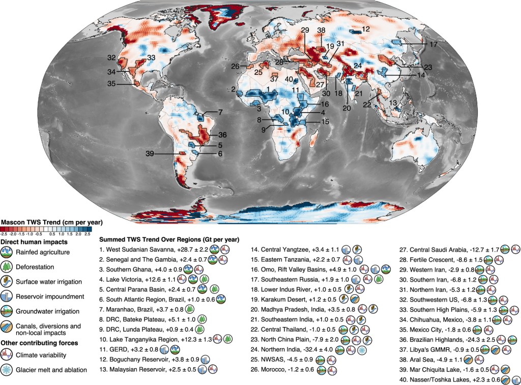
Human activities are known to affect the water cycle and the distribution of water resources, but measuring these impacts from space is difficult. Using raw satellite data, this study mapped changes in water storage across the world at a much finer scale. It identified human-driven water storage changes in 40 regions. Land and water use were strongly linked to these changes in all nonpolar continents except Australia, with agriculture-driven groundwater depletion being particularly severe.
URBAN LAKES, WETLANDS
Citizens seek environmental assessment of Hebbal tunnel project A delegation of citizens met Forest, Ecology and Environment Minister Ramalinga Reddy and submitted a petition with over 21,000 signatures, seeking an assessment of the environmental impact of the proposed Hebbal short tunnel project. In a letter to the minister, the citizens cited the Supreme Court’s recognition of water bodies as public-trust natural resources and the state’s duty to prevent environmental degradation. The delegation also called for the project’s impact on biodiversity, groundwater, lake hydrology and flood risk to be assessed together, rather than treating the trees and lake as isolated elements. It urged the Environment Department to ensure that independent ecological, wildlife, tree, hydrological and groundwater assessments are completed and less damaging alternatives examined before tree felling or further ecological intervention.
Sewage stains Chennai’s Chembarambakkam The Tamil Nadu Pollution Control Board (TNPCB) has directed the Metro Water to plug unauthorised stormwater drains and wastewater canals leading to Chembarambakkam Lake – the major drinking water source for Chennai and its suburbs – after water samples from channels feeding the reservoir showed high levels of organic pollution and faecal contamination.
The TNPCB proceeding was issued recently under Section 33A of the Water (Prevention and Control of Pollution) Act, 1974, following an inspection of 16 sampling points around the lake a few days ago. The Board had collected samples on May 22 and May 27 from canals and lake-border locations and found that several parameters did not conform to prescribed standards.
URBAN WATER
HC calls for ‘aggressive measures’ to tackle Gurugram water crisis In an order passed on September 22, a bench comprising Chief Justice Ashwani Kumar Mishra and Justice Rohit Kapoor observed that the city’s proximity to the National Capital has made rapid urbanisation and population influx inevitable, yet basic water resource governance has lagged dangerously behind.
The HC noted that indiscriminate extraction through private borewells over several decades has triggered a steep drop in the GW table across municipal limits. Concurrently, natural catchment systems have collapsed. “Further, the existing natural water bodies have substantially diminished, while the channels that sustained these water bodies remain largely blocked,” the bench said.
It observed that while Gurugram witnesses severe waterlogging every monsoon, the accumulated runoff is not being channelled into replenishing the underground aquifers. The judges raised concerns regarding the inadequate treatment and reuse of wastewater, pointing out that sewage treatment plants are not being operated to their optimum capacity to offset freshwater demand.
The HC directed that the Chief Engineer of Municipal Corporation of Gurugram (MCG), Gurugram deputy commissioner, officers in-charge of Haryana Shehri Vikas Pradhikaran as well as officials of Gurugram Metropolitan Development Authority to appear before it via videoconferencing on October 1, the next date of hearing.
The bench had in August called upon the Central Ground Water Authority, under the Union Ministry of Water Resources, to submit a comprehensive affidavit assessing the current depletion rates and water tables within Gurugram’s municipal boundaries.
Earlier this month, the Haryana Human Rights Commission (HHRC) had initiated suo motu proceedings following heavy rain on August 24 that submerged arterial stretches, stranded school buses, and caused a major road cave-in near IFFCO Chowk.
In an order passed on September 8, the HHRC said the seasonal chaos is an institutional lapse attributable to neglect and lack of preventive measures and called for a thorough technical audit apart from GIS-based mapping to clear encroachments choke-holding natural storm drains and child-commuter safety protocols during inundations.
Mumbai’s ₹13K cr. flood control plan The Brihanmumbai Municipal Corporation (BMC) has prepared an integrated flood-control action plan estimated at about Rs 13,000 crore to address recurring monsoon waterlogging, with measures covering drainage capacity, pumping systems, nullah improvements, the Mithi River and nature-based interventions.
The BMC has invited tenders to appoint a consultant for the project. The consultant is expected to prepare a DPR within 9 months and will receive a fee of Rs 110 crore, according to a report by Loksatta. The report does not state the full implementation schedule or the funding breakdown for the proposed plan. The civic body plans to stop up to 90% of such waste from reaching the nullahs during the 2028 monsoon, the report said.
Pouring ₹13K cr. down the drain The dire social and environmental costs of the degradation of rivers and lakes, shrinking of green spaces and wetlands, and loss of coastal habitats and livelihoods, arising out of the city’s planning make it obvious that Mumbai’s development model values its land over – and often at the cost of – its water.
The growth of such value demands an ever-increasing appetite for concretising more land, which in turn reduces its capacity to soak water. Hence, it is not really lack of planning or corruption that shapes Mumbai’s uneven, real-estate driven urban development, as is popularly argued, but rather this specific kind of planning. Planning tools such as zoning, building regulations and bylaws are meticulously designed and modified to achieve the highest price from land.
Similarly, to propose solutions to Mumbai’s drainage problems, there needs to be a thorough understanding of what causes them in the first place. But the last official analysis of Mumbai’s drainage was conducted over two decades ago by the Chitale Committee in 2006. For a city where redevelopment outpaces development, such studies should have ideally been conducted annually at best or every five years at least.
It is, thus, not incidental that a city thirsting for water is transformed, in a matter of a few hours of intense rainfall, into one that’s drowning in water. When considering the “sponge-city” based integrated masterplan, it is worth asking if it has been proposed without any critical assessment of the city’s ecology. Are solutions being planned before analysing the problem?
Mumbai’s consultants and planners are quick to pick “best practices” for flood mitigation from other cities, but leave out the more important aspects of planning and governance underlying their implementation. In fact, the 2006 Chitale Committee report had recommended setting up a Mumbai Watershed Council for efficient stormwater management. But this, like most of its other recommendations, was completely ignored.
We must dismantle the notion that engineers & planners know Mumbai’s drainage best. The resolution of the problem demands expertise from hydrologists, geologists, geographers, sociologists, landscape architects, botanists, conservationists & more importantly, citizens. Public funds ought to be used through public participation, deliberation and debate. (Lekha Samant)
HMWSSB launches ₹550cr. Manjeera water system overhaul The Manjeera transmission network has been serving Hyderabad for nearly five decades. Built with cement pipelines in the early 1970s, the system has become prone to failures. HMWSSB has invited bids for the works. The project is expected to be completed within 24 months.
Under the project, HMWSSB will set up a 232 MLD water treatment plant at Kalabgoor. The works will also include a new intake well, pump house and transmission facilities to connect the plant with Patancheru and other areas of Hyderabad. A six-million-gallon clear water reservoir, a clear water pumping station and an electrical substation are part of the project.
Villagers oppose STP in Ranipet Villagers, mostly farmers and traders, staged a protest on Arakkonam – Sholinghur Main Road, on Friday against setting up a new STP in Udayarpalayam hamlet by Sholinghur municipality due to fear of pollution of ground water in surrounding farming villages and Palar River. Residents said Udayarpalayam hamlet forms part of Pandiyanallur village panchayat that comes under Sholinghur panchayat union in the district. The hamlet has around 1,500 residents, who are mostly farmers and petty traders.
MONSOON 2026
IMD’s daily (28.09.2026) and Cumulative (01.06.2026 to 28.09.2026) distict wise rainfall figures.
Mah CM says drought this year could be worse than 1972 drought Maharashtra is heading for a severe drought which is likely to be worse than that of 1972 (considered worst ever in the state’s recorded past), Chief Minister Devendra Fadnavis said on Sept 23, adding the government would issue a notification shortly. Describing the situation in Latur and Dharashiv in Marathwada region as “extremely serious”, the CM said that the two districts received only half the normal rainfall this year, and promised all possible assistance to the affected farmers. Along with Marathwada region, several other districts in Mah are reeling under severe rain deficit, CM said.
The long gap between two rains after sowing — stretching up to 36 days — led to crop failure. In some talukas, the intense rain in shortest duration led to soil erosion, damanging the kharif crop. absence of return rain has compounded the crisis for farmers as they will not only fail to salvage their kharif crop on 147 lakh hectares but also stare at an uncertain rabi season beginning November across 61 lakh hectares of land.
Maharashtra declares drought in 75% of state The declaration comes as the state enters the final days of the monsoon with a significant rainfall deficit. From June 1 to September 26, Maharashtra has received 798.2 mm of rainfall against a normal 970.9 mm, a deficit of 18%. Except for five districts, the state has recorded deficient rainfall during the period. The situation is particularly acute in Marathwada, where the eight districts together have recorded a 38% deficit. It ranges from 16% in Chhatrapati Sambhajinagar to 48% in Hingoli.
The government’s declaration does not immediately determine the crop compensation individual farmers will receive. District administrations will first conduct panchnamas and document the condition of crops with the help of photographs and GPS coordinates. The reports will be submitted through the Agriculture Commissioner, following which the government will issue a separate order on financial assistance.
The declaration comes despite some rainfall activity towards the end of the monsoon. A depression over the Bay of Bengal brought moderate to heavy showers to parts of Kolhapur, Satara and Gadchiroli, but the rainfall was not sufficient to bridge the deficit accumulated across much of the state. There are only five districts in the state that have recorded surplus rain — Mumbai City, Mumbai Suburban, Pune, Nashik and Satara.
DAM FLOOD 2026
All 14 gates of Gangrel Dam opened Official data released at 8 am on Sept. 25 showed that Murumsilli reservoir was at 100% capacity, while Gangrel stood at 98.14%, Dudhawa at 97.21%, and Sondur at 88.18%. Water management authorities have begun releasing water from various reservoirs to manage the incoming flow and ensure safety.
The inflow at Gangrel reservoir reached 64,117 cusecs, forcing officials to open 10 gates to discharge 54,950 cusecs of water. Of this, 6,000 cusecs is being routed into the canal system through Rudri barrage, while 48,950 cusecs is being directed into Mahanadi. Officials noted that water discharge is being carried out as a precautionary measure to handle the rising inflows.
Similarly, Murumsilli reservoir recorded an inflow of 7,465 cusecs against a discharge of 7,286 cusecs into the river. Dudhawa reservoir logged an inflow of 18,724 cusecs and a discharge of 16,606 cusecs. Sondur reservoir saw an inflow of 16,624 cusecs, with 16,402 cusecs being released into the river through five gates. Authorities added that discharge rates may be increased if water levels continue to rise.
Following the massive release of water into Mahanadi and its tributaries, the district administration has issued an alert to all villages situated along the riverbanks to guard against potential flooding. Local authorities have urged residents to exercise caution and take necessary safety precautions.
FLOOD 2026
“What a 1-in-100 flood really means? Return periods: understanding probability. One of the most common sources of confusion in disaster risk comes from expressions such as “a 1-in-100-year flood” or “a 1-in-200-year earthquake.” These phrases are widely used in disaster risk reduction, yet they are often misunderstood.
A 1-in-100 flood does not mean once every 100 years or that they are safe for 99 years. It means a flood with a 1% chance of being exceeded in any given year. Instead, it is a way of describing chance, not timing. Specifically, a 1-in-100-year event has a 1% probability of being exceeded in any given year. That same flood can happen this year, next year, or several times in a lifetime.
This distinction is subtle, crucial. Probability does not work like a calendar. Each year is a new roll of the dice. That it happened recently does not reduce the chance of it happening again soon.
HFL BREACH
1 River Chandrawal at Kaithi site in Hamirpur district, Uttar Pradesh has crossed its HFL 101.99 meter dated 27.08.2022 at 22:00 hour on 26.09.2026.
2 River Gandak at Bagaha site in Pashchim Champaran has crossed its HFL 90.9 meter dated 19.09.2024 at 07:00 hour on 28.09.2026.
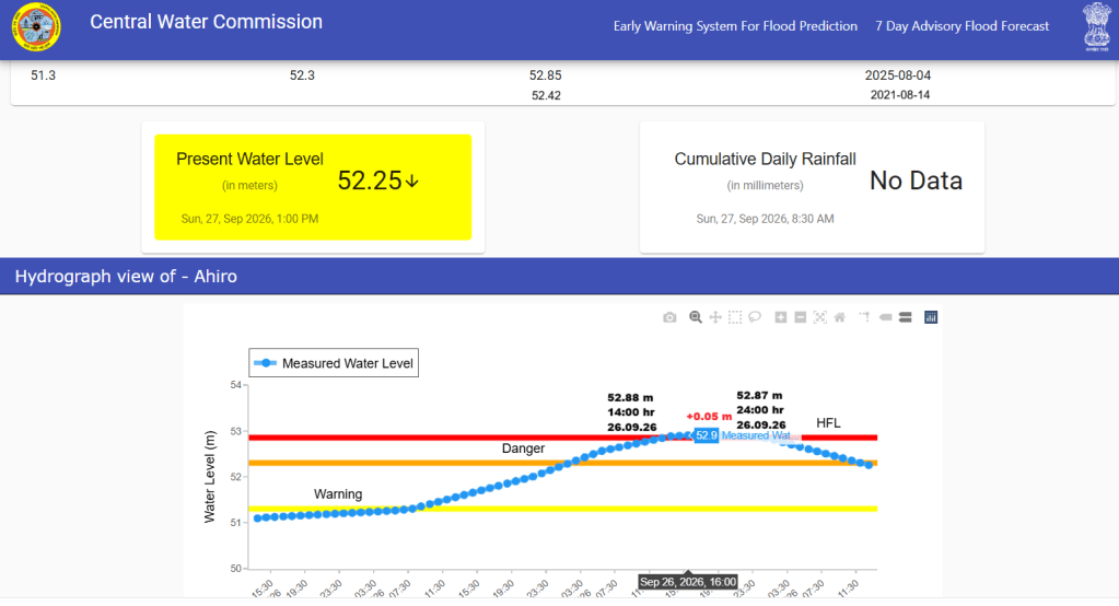
3 Gerua river at Ahiro site in Banka district has crossed its HFL 53.85 meter dated 04.08.2025 at 14:00 hour and has set a new HFL 52.9 meter at 16:00 hour on 26.09.2026.
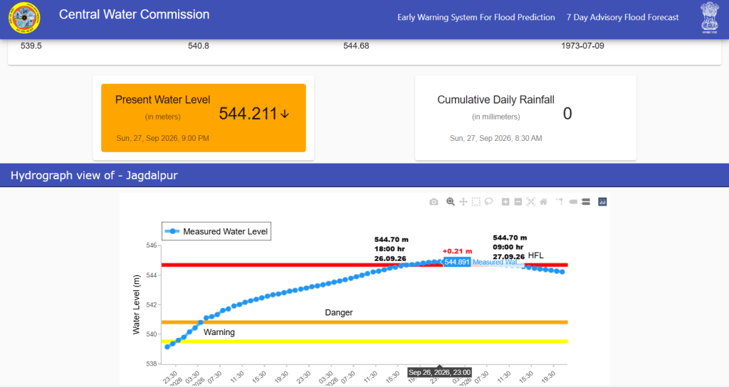
4 It’s after 53 years that river Indravathi at Jagdalpur site in Bastar district, Chhattisgarh has crossed its HFL 544.68 meter dated 09.07.1973. The Flood level in river is forecasted to reach 545.05 meter at 02:00 hour on 27.09.2026.
5 River Baitarani at Bhadrak site in Bhadrak district has breached HFL second time in this monsoon season. The river crossed HFL 13.93 meter dated 31.07.2026 at 13:00 hour on 26.09.2026.
6 River Narangi at Sonarpal site in Bastar district, Chhattisgarh has crossed its HFL 543.2 meter dated 21.08.2020 at 22:00 hour on 25.09.2026 and has set 543.43 meter as new HFL at 04:00 hour on 26.09.2026. The new HFL is 0.23 meter higher than the old HFL.
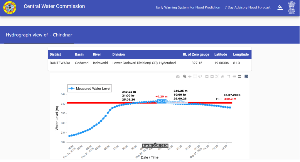
7 After 20 years, River Indravathi at Chindnar site in Dantewada district, Chhattisgarh has crossed its HFL 340.2 meter dated 05.07.2006 21:00 hour on 25.09.2026 and set 340.49 meter as new HFL at 05:00 hour on 26.09.2026. The new HFL is 0.29 meter higher than the old HFL.
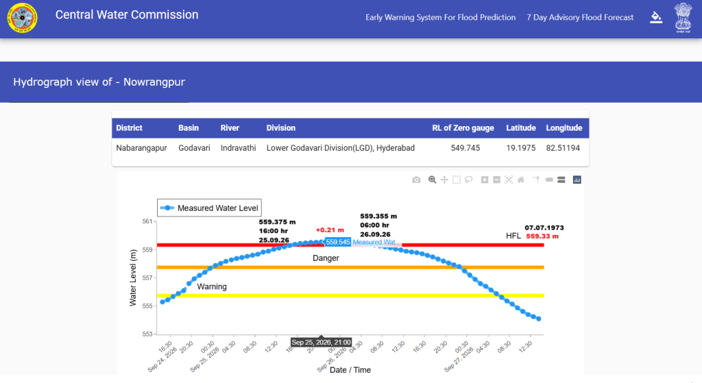
8 It’s after 53 years that River Indravathi at Nowrangpur site in Nabarangapur district Odisha has crossed its HFL 559.33 meter dated 07.07.1973 at 16:00 hour on 25.09.2026.
9 River Journala at Ghatakusumi site in Nabrangapur district Odisha has again crossed it HFL 547.37 meter dated 24.08.2026 at 14:00 hour on 25.09.2026.
10 River Sabari in Godavari basin at Talnar site in Sukma district Chhattisgarh has crossed it HFL 211.28 meter dated 08.08.2022 at 10:00 hour on 25.09.2026.
11 River Baitarani at Bhejdih site in Mayurbhanj district Odisha has again crossed its HFL 293.41 meter dated 14.09.2021 at 03:00 hour on 25.09.2026.
12 River Baitarani at Keshdihi site in Mayurbhanj district has again crossed its HFL 317.79 meter dated 26.08.2020 at 06:00 hour on 25.09.2026.
13 River Nagavali at Janjhavati site in Vizianagaram district has crossed its HFL 119.22 meter dated 24.10.2019 at 18:00 hour on 24.09.2026 and set 120.38 meter as new HFL at 02:00 hour on 25.09.2026. The new HFL is is 1.16 meter higher than the old HFL. The flood level at the site increased by 2.76 meter in just one hour from 116.74 meter at 17:00 hour to 119.5 meter at 18:00 hour on 24.09.2026.
14 River Pamuleru at Valamuru site in East Godavari district, Andhra Pradesh has crossed its HFL 395.82 meter dated 26.07.2023 at 03:00 hour on 24.09.2026. After HFL breach at the site the CWC has changed the HFL details of Pamuleru river at Valamuru site in East Godavari District, Andhra Pradesh from 395.82 meter dated 26.07.2023 to 398.145 meter dated 07.08.2019. This means the river has not breached the HFL as was shared by the CWC early in the morning.
15 River Godahada at Kurula site in Ganjam district, Odisha has crossed its HFL 32.1 meter dated 29.10.2025 at 07:00 hour on 24.09.2026
SOUTH ASIA
NEPAL DISASTER What went wrong and what’s next? This Frontline Webinar examines the region’s disaster management frameworks, resources and policies. In the latest edition of the Frontline webinar, Vedaant Lakhera speaks with Vinod Kumar Gaur, Honorary Emeritus Scientist at CSIR-National Institute of Data Science & AI, Bengaluru; Himanshu Thakkar, Coordinator of SANDRP; and Rishika Pardikar, environment and climate reporter. The discussion looked at the science behind the Nepal floods, the state of disaster preparedness across South Asia, and the need for stronger regional cooperation.

Is Nepal’s flood a harbinger of what’s to come in the Himalayas? “Why did it have to happen in the first place?” asked Parineeta Dandekar, an expert on rivers who has written critically about these projects for the South Asia Network on Dams, Rivers and People (SANDRP). Dandekar accuses the World Bank of producing a flawed risk assessment report for the project from the get-go. Its many omissions, Dandekar says, included ignoring “the cumulative disaster risk that can happen after having so many projects across the same river.” Experts say the Trishuli river basin has 36 hydro power projects — including the dozen now under the mud.
Dandekar says the constant blasting of mountains to build these projects, including for miles-long tunnels, has its own impact. It’s a region where earthquakes and landslides are common, and where climate change is causing its glaciers to melt more rapidly, making them — and their slopes — more unstable. Initial analysis suggests global warming exacerbated the melting of the glacier that snapped off in August, triggering flash floods.
Dipak Gyawali and other experts said developers were not seriously investigating the risk caused by so many projects built in the same zone. “These risks have to be properly studied and assessed. Unfortunately, they have not been,” Gyawali said. Retired Indian ambassador Shyam Saran, who served as the Indian prime minister’s special envoy for climate change, says developers typically look at risks that could be triggered by their project, alongside environmental risks to it, and they appear safe. “But if you do actually a cumulative environmental impact assessment of the whole river system,” he says, “then a different picture emerges.”
“If something happens, it is going to be a monumental disaster,” says retired ambassador Saran regarding the Great Bend Project China is developing in the same Himalayan region. He says Chinese authorities have assured their neighbors that the hydro project is safe. “But as we see,” he says, “those precautions which supposedly had been taken don’t mean very much when you have nature’s fury to deal with.” (By Mamita Bhandari, Diaa Hadid)
Precursory deformation before the Rasuwa Disaster According to Dave Petley blog dated Sept 16, 2026, a new paper (Wang et al. 2026) suggests that the bedrock failure that initiated the Nepal landslide disaster may have displayed measurable precursory deformation. The authors of the paper have compared movement of the main glacier from 2018 to now, which was not involved in the landslide, and of the hanging glacier under which the landslide occurred. Until the early part of 2026, the two glaciers moved at a linear rate, although the main glacier moved at a much higher rate than the hanging glacier. But, from late 2025 or early 2026, the hanging glacier started to move faster, and from that point onwards showed a dramatically accelerating trend to failure.
Presumably, this is the development of failure in the underlying bedrock being transmitted through to the ice. By the end, the movement rate had increased from about 7.4 m/year to about 55 m/ year. This however does not mean that the disaster could have been predicted.
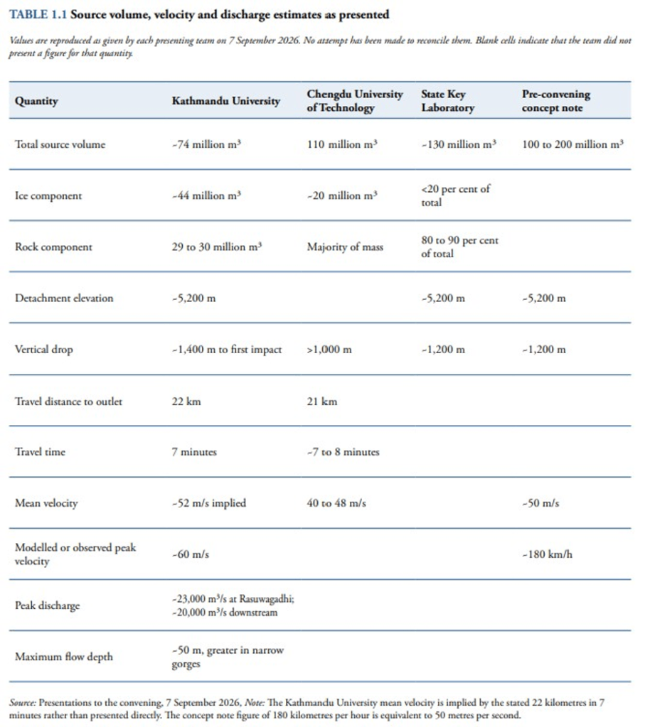
Range of parameters in Rasuwa Disaster As per Dave Petley blog of Sept 15, 2026, the Youth Innovation Lab in Nepal has posted a very interesting review of the event – the document is here as a PDF. This reports on a workshop convened a couple of weeks after the event by the Youth Innovation Lab with the Red Cross Red Crescent Climate Centre, Kathmandu University and the University of Twente, with the Ministry of Energy, Water Resources and Irrigation. It included local and international experts and it examines the event itself, the response and early lessons learnt. For example, it provides an initial analysis of the range of parameters involved in the landslide, debris flow and debris flood provided by different analyses:-
In an earlier blog dated Sept 7, 2026, Dave Petley highlighted that the landslide was very large. The source zone is about 2,000 metres long and the elevations are about 5,140 metres at the crown and 3,990 metres at the toe, so about 1,150 metres. This is a very steep slope. The volume is about 100 Million Cubic Meters considering the seismic impact of the fall. The imagery clearly shows that the shear surface was in bedrock, not within the ice or at the ice-rock boundary. At the crown, the interface between the glacier and the bedrock is clear, confirming that this was primarily a bedrock landslide.
This has now left a very steep slope, albeit one without overhangs, so the potential for further collapses should be considered. The geomorphology of this area & the slopes along the channel downstream, are now going to evolve. This could involve further collapses in the coming years.
The scale of the landslide is not unprecedented. Three much larger landslides and debris flows are recorded in valley fills in the Pokhara area of Nepal. These events are related to earthquakes that occurred in ∼1100, 1255, and 1344 AD – i.e. in the medieval period. These three events generated about 5 km3 of sediment. The potential for even larger landslides must be considered when proposals to mitigate these hazards through the construction of even larger dams are made.
Petley also says: “I am uncertain as to whether this particular event has a climate change signature. It is entirely possible that this was a progressive failure in a slope that was both oversteepened and deteriorating.”
Over 800 people remain missing from hydropower projects: Energy Minister Biraj Bhakta Shrestha told Parliament on Sept. 23: – More than 800 people working at hydropower projects and related facilities remain unaccounted for nearly a month after the Bhotekoshi floods. Of those missing, 47 are employees of the Nepal Electricity Authority.
-The largest number of missing people are linked to the 216-MW Upper Trishuli-1 project. Of the 1,433 people working there before the flood, 955 were rescued or later made contact themselves, while 439 remain unaccounted for, according to the minister. A Chinese national was rescued alive from the project on the 12th day after the flood. Thirty-nine bodies have so far been recovered from the project’s tunnel.
-At the Upper Trishuli-3A project, 39 people remain unaccounted for. Two employees, Sanjay Sah and Kabir Maharjan, were rescued alive on the 10th day of the disaster. One body was recovered from the project.
– 178 people remain unaccounted for at Upper Trishuli-3B, 93 at Rasuwagadhi Hydropower Project, 7 at Mailung Khola Hydropower Project and 3 at Rasuwa-Bhotekoshi Hydropower Project. At Langtang Khola Hydropower Project, 39 people are still missing. 19 people were rescued and 2 bodies were recovered, he said.
– Five Nepal Electricity Authority employees were found dead during search and rescue operations at the powerhouse of Chilime Hydropower Station. One employee remains unaccounted for.
-Two people are missing from the Madhya Trishuli Ganga Hydropower Project and three from the Trishuli Hydropower Station. Employees are also missing from the Devighat Hydropower Station, the Trishuli-3B hub, the Rasuwa Distribution Centre and the Chilime-Trishuli transmission line, although the minister did not give separate figures for those sites.
Hydropower Tunnel maze that trapped hundreds of workers This Reuters feature with maps and photos explain how hundreds of hydropower workers got trapped in the maze of tunnels of about 12 hydropower projects during the Rasuwa disaster starting from Aug 26 2026.
Ganga Water Treaty Bihar looks beyond Farakka The State’s future water security depends on a much larger framework—Himalayan catchments, Nepal, upstream abstraction, tributary flows, sediment management, groundwater, floodplain management, navigation and ecological sustainability. The challenge before Bihar is therefore to move from episodic political demands towards a long-term basin strategy backed by credible data and scientific evidence.
The December review of the Ganga water-sharing arrangement should not become merely another contest between competing claims. It could instead provide an opportunity to build a more transparent and cooperative institutional framework for the Ganga basin. For Bihar, the larger demand is not simply for more water. It is for a meaningful voice in decisions that determine the quantity, timing, quality and ecological health of the river on which much of its economy and society depend. (Kumar Krishnan)
WORLD
USA Economic value of wetlands in reducing riverine flood losses Abstract: Here we address this challenge by quantifying the effects of wetlands in reducing riverine flood losses across the USA using flood insurance claims data and annually observed changes in wetland area between 1985 and 2023. We find that claim amounts for individual properties increase by 0.01–0.03% per hectare of upstream wetland loss. Based on these effects, we estimate that wetland loss since 1985 has increased flood insurance claims by a total of US$10.1 billion or 9.0%. We also calculate the marginal value of wetlands in reducing riverine flood losses for each subwatershed in the USA. In 16% of subwatersheds, the marginal benefits of flood mitigation outweigh the marginal costs of land conservation. Policymakers can use this information for conducting regulatory impact assessments, designing land-use policies & pricing flood insurance.
SANDRP
Also see: DRP 21 Sept. 2026 & DRP 14 Sept. 2026
Follow us on: www.facebook.com/sandrp.in; https://twitter.com/Indian_Rivers


