
Flood forecasting is an important activity during monsoon, considering the huge and increasing flood prone area, flood frequency, extent and flood damages. Accurate and timely flood forecasting can hugely help reduce the damages due to floods. Central Water Commission (CWC) is the only agency responsible for flood forecasting in India. To understand the CWC’s flood forecasting better, we have compiled the list of the various flood, inflow forecasting sites and flood monitoring sites in India.
In this compilation, we have given state wise list of CWC’s flood forecasting, flood monitoring and inflow forecasting sites, along with available details like rivers, sub basin, river basin, Warning level, Danger Level, High Flood Level, Full Reservoir Level, Maximum Water Level. As we see below, there are many gaps in this basic information for the sites that are part of CWC’s list.
JAMMU AND KASHMIR There are 3 flood forecasting and 1 level monitoring site in Jammu & Kashmir. There is no inflow monitoring site in the state. HFL details for Khanabal site on Jhelum are not given where the hydrograph for the site is active.
List of Flood Forecasting Sites
| SN | Site | River | Sub-Basin / Basin | District | WL, M | DL, M | HFL, M | HFL Date |
| 1 | Sangam | Jhelum | Jhelum/ Indus | Anantnag | 1590.3 | 1591.2 | 1595.7 | 09-06-2014 |
| 2 | Rammanushi bagh | Jhelum | Jhelum/ Indus | Srinagar | 1585.53 | 1586.45 | 1589.65 | 08-09-2014 |
| 3 | Safapora | Jhelum | Jhelum/ Indus | Baramula | 1580.0 | 1580.5 | 1581.05 | 26-06-2015 |
Warning Level – WL; Danger Level – DL; High Flood Level – HFL; Meters – M
List of Level Monitoring Sites
| SN | Site | River | Sub-Basin / Basin | District | HFL (M) | HFL Date |
| 1 | Khanabal | Jhelum | Jhelum/ Indus | Anantnag | NA | NA |
HIMACHAL PRADESH There are 1 flood forecasting and 16 level monitoring stations in Himachal Pradesh. Out of 16 level monitoring sites 6 are inactive. The Hanuman Chetty site shown in Chamba district is actually in Uttarkashi district of Uttarakhand. The HFL details for 10 level monitoring sites are not provided.
List Flood Forecasting Sites
| SN | Site | River | Sub-Basin / Basin | District | WL | DL | HFL, M | HFL Date |
| 1 | Paonta | Yamuna | Upper Yamuna/ Ganga | Sirmaur | 383.5 | 384.5 | 384.6 | 05-09-1995 |
List of Level Monitoring Sites
| SN | Site | River | Sub-Basin / Basin | District | HFL, M | HFL Date |
| 1 | Hanuman Chetty[I] | Yamuna | Upper Yamuna/ Ganga | Chamba | NA | NA |
| 2 | Khab | Satluj | Satluj/ Indus | Kinnaur | NA | NA |
| 3 | MOORANG | Satluj | Satluj/ Indus | Kinnaur | NA | NA |
| 4 | TITANG | Satluj | Satluj/ Indus | Kinnaur | 2460.0 | 03-08-2005 |
| 5 | POWARI | Satluj | Satluj/ Indus | Kinnaur | 1945.0 | 03-08-2005 |
| 6 | NATHPA | Satluj | Satluj/ Indus | Kinnaur | 1451.0 | 03-08-2005 |
| 7 | RAMPUR | Satluj | Satluj/ Indus | Shimla | 933.0 | 03-08-2005 |
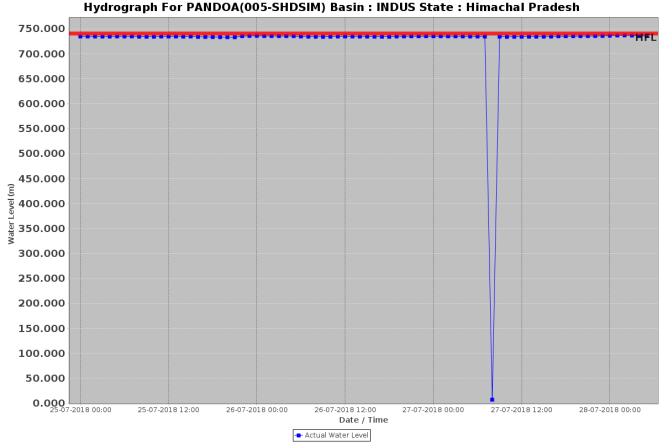
| 8 | PANDOA | Satluj | Satluj/ Indus | Shimla | 740.6 | 03-08-2005 |
| 9 | Ropa | Ropakhad | Satluj/ Indus | Kinnaur | NA | NA |
| 10 | Sangla | Baspa | Satluj/ Indus | Kinnaur | NA | NA |
| 11 | Shalkhar | Spiti | Satluj/ Indus | Kinnaur | NA | NA |
| 12 | Ghaluwal | Swan | Satluj/ Indus | Una | NA | NA |
| 13 | Barshani | Beas | Beas/ Indus | Kullu | NA | NA |
| 14 | KOTHI | Beas | Beas/ Indus | Kullu | NA | NA |
| 15 | Jateon Barrage[II] | Giri | Upper Yamuna/ Ganga | Sirmaur | NA | NA |
| 16 | Yaswant Nagar | Giri | Upper Yamuna/ Ganga | Sirmaur | 902.9 | 05-09-1995 |
UTTRAKHAND The state has 28 flood monitoring sites including 4 flood forecasting, 23 level monitoring and 1 inflow monitoring site. There is one inactive site in the state which is Harshil on Ganga river in Uttarkashi district.
List Flood Forecasting Sites
| SN | Site | River | Sub Basin/ Basin | District | WL | DL | HFL, M | HFL Date |
| 1 | Ganga Nagar | Mandakani | Alaknanda/ Ganga | Chamoli | 803.0 | 804.0 | 808.0 | 16-06-2013 |
| 2 | Rishikesh | Ganga | U Ganga/ Ganga | Dehradun | 339.5 | 340.5 | 341.72 | 05-09-1995 |
| 3 | Haridwar | Ganga | U Ganga/ Ganga | Haridwar | 293.0 | 294.0 | 296. 3 | 17-06-2013 |
| 4 | Srinagar | Alaknanda | Alaknanda/ Ganga | Garhwal | 535.0 | 536.0 | 537.9 | 17-06-2013 |
List of Level Monitoring Sites
| SN | Site | River | Sub Basin/ Basin | District | HFL, M | HFL Date |
| 1 | Bhikiasen | Ramganga | Ramganga/ Ganga | Almora | 791.2 | 17-09-2010 |
| 2 | Kalagarh | Ramganga | Ramganga/ Ganga | Garhwal | 263.67 | 19-09-2010 |
| 3 | Badrinath | Alaknanada | Alaknanda / Ganga | Chamoli | 3112.7 | 01-08-2007 |
| 4 | Joshimath | Alaknanda | Alaknanda / Ganga | Chamoli | 1385.54 | 28-06-2013 |
| 5 | Rudraprayag (A) | Alaknanda | Alaknanda / Ganga | Rudraprayag | 634.85 | 17-06-2013 |
| 6 | Rudraprayag (Conf) | Alaknanda | Alaknanda / Ganga | Rudraprayag | 633.0 | 17-06-2013 |
| 7 | Uttarkashi | Bhagirathi-1 | Bhagirathi / Ganga | Uttarkashi | 1124.13 | 06-08-1978 |
| 8 | Deoprayag (B) | Bhagirathi-1 | Bhagirathi / Ganga | Tehri-Garhwal | 474.5 | 17-06-2013 |
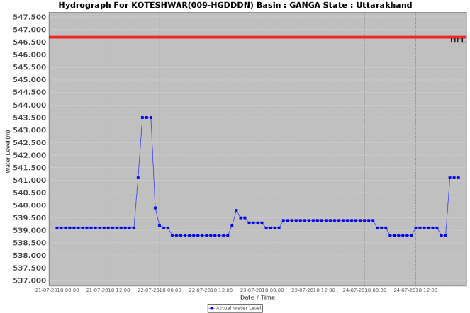
| 9 | Koteshwar | Bhagirathi-1 | Bhagirathi / Ganga | Tehri-Garhwal | 546.7 | 15-08-2013 |
| 10 | Harshil | Bhagirathi-1 | Bhagirathi / Ganga | Uttarkashi | NA | NA |
| 11 | Marora | Nyar | Ramganga/ Ganga | Chamoli | 556.6 | 12-09-1993 |
| 12 | Nandkeshri | Pinder | Alaknanda / Ganga | Chamoli | 1267.4 | 17-06-2013 |
| 13 | Karnaprayag | Pinder | Alaknanda / Ganga | Chamoli | 774.05 | 17-06-2013 |
| 14 | Jouljibi | Sarda | Ghagra/ Ganga | Pithoragarh | 607.6 | 17-06-2013 |
| 15 | GHAT | Sarda | Ghagra/ Ganga | Pithoragarh | 472.0 | 16-08-2011 |
| 16 | Pancheshwar | Sarda | Ghagra/ Ganga | Champawat | 432.5 | 16-08-2011 |
| 17 | Rudraprayag (M) | Mandakani | Alaknanda / Ganga | Rudraprayag | 634.0 | 17-06-2013 |
| 18 | Haripur | Tons South | Upper Yamuna/ Ganga | Dehradun | 482.48 | 25-09-1988 |
| 19 | Tuini (Pabar) | Pabar | Upper Yamuna/ Ganga | Dehradun | 931.88 | 25-09-1988 |
| 20 | Tuini (Tons) | Tons | Upper Yamuna / Ganga | Dehradun | 904.0 | 24-09-1988 |
| 21 | Deoprayag (G) | Ganga | U Ganga / Ganga | Garhwal | 472.5 | 17-06-2013 |
| 22 | Kanjyoti | Dhuilganga | Ghagra / Ganga | Pithoragarh | NA | NA |
| 23 | Naugaon | Yamuna | Upper Yamuna/ Ganga | Uttarkashi | 1060.4 | 11-09-2010 |
List of Inflow Monitoring Sites
| SN | Site | River | Sub-Basin/ Basin | District | FRL | MWL |
| 1 | Banbasa | Sarda | Ghagara / Ganga | Champawat | NA | NA[III] |
PUNJAB, Chandigarh No flood forecasting, level monitoring and inflow monitoring sites are there from Punjab or Chandigarh.
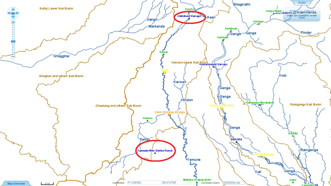
HARYANA There are 1 flood forecasting, 3 level monitoring and 1 inflow site in the state. Tajewala Wier site (Hathinikund) is also mentioned in CWC list but the site is inactive and on CWC, Data Flow Map link it is shown far away from the actual location. The weir has been completely destroyed by the 2010 floods in River Yamuna.
List of Flood Forecasting Sites
| SN | Site | River | Sub-Basin/ Basin | District | WL | DL | HFL, M | HFL Date |
| 1 | Karnal | Yamuna | Upper Yamuna/ Ganga | Karnal | 248.8 M | 249.5 M | 250.07 | 17-06-2013 |
The CWC’s Standard Operating Procedure document for flood forecasting for 2018[IV], however, gives the HFL as 250.01m, crossed on19.09.2010.
List of Level Monitoring Sites
| SN | Site | River | Sub-Basin/ Basin | District | HFL (M) | HFL Date |
| 1 | Mohna | Yamuna | Middle Yamuna/ Ganga | Faridabad | 193.13 M | 06-09-1978 |
| 2 | Masani | Yamuna | Middle Yamuna/ Ganga | Rewari | 242.58 M | NA |
| 3 | Dadri | Sahibi | Upper Yamuna/ Ganga | Jhajjar | 214.98 M | 26-08-2008 |
List of Inflow Monitoring sites
| SN | Sites | River | Sub-Basin/ Basin | District | FRL | MWL |
| 1 | Hathinikund Barrage | Yamuna | Upper Yamuna/ Ganga | Yamuna Nagar | NA | NA[V] |
DELHI- Delhi has 3 sites including 2 flood forecasting and 1 level monitoring.
List of Flood Forecasting Sites
| SN | Site | River | Sub-Basin/ Basin | District | WL | DL | HFL, M | HFL Date |
| 1 | Delhi Railway Bridge | Yamuna | Upper Yamuna/ Ganga | North | 204.0 | 204.83 | 207.49 | 06-09-1978 |
| 2 | Dhansa | Sahibi | Upper Yamuna/ Ganga | South West | 211.44 | 212.44 | 213.58 | 06-08-1977 |
List of Level Monitoring Sites
| SN | Site | River | Sub-Basin/ Basin | District | HFL (M) | HFL Date |
| 1 | Palla | Yamuna | Upper Yamuna/ Ganga | North West | 212.275 M | 00-09-1988[VI] |
UTTAR PRADESH- There are 37 flood forecasting, 47 level monitoring and 3 inflowing monitoring sites in Uttar Pradesh. 4 of level monitoring are not active and 1 of inflow monitoring sites are not fully active in the state.
List of Flood Forecasting Sites
| SN | Site | River | Sub-Basin/ Basin | District | WL | DL | HFL (M) | HFL Date |
| 1 | Mawi | Yamuna | Upper Yamuna/ Ganga | Muzzafar Nagar | 230.0 | 230.85 | 232.75 | 18-06-2013 |
| 2 | Mathura (Prayag Ghat) | Yamuna | Middle Yamuna/ Ganga | Mathura | 165.2 | 166.0 | 169.73 | 08-09-1978 |
| 3 | Agra (J.B.) | Yamuna | Middle Yamuna/ Ganga | Agra | 151.4 | 152.4 | 154.76 | 09-09-1978 |
| 4 | Etawah | Yamuna | Middle Yamuna/ Ganga | Etawah | 120.92 | 121.92 | 126.13 | 11-09-1978 |
| 5 | Auraiya | Yamuna | Lower Yamuna/ Ganga | Auraiya | 112.0 | 113.0 | 118.19 | 25-08-1996 |
| 6 | KALPI | Yamuna | Lower Yamuna/ Ganga | Jalaun | 107.0 | 108.0 | 112.98 | 25-08-1996 |
| 7 | SHAHIJINA | Yamuna | Lower Yamuna/ Ganga | Hamirpur | 103.54 | 104.54 | 108.67 | NA |
| 8 | HAMIRPUR | Yamuna | Lower Yamuna/ Ganga | Hamirpur | 102.63 | 103.63 | 108.59 | 12-09-1983 |
| 9 | CHILLAGHAT | Yamuna | Lower Yamuna/ Ganga | Banda | 99.0 | 100.0 | 105.16 | 06-09-1978 |
| 10 | NAINI | Yamuna | Lower Yamuna/ Ganga | Allahabad | 83.74 | 84.73 | 87.99 | 08-09-1978 |
| 11 | MOHANA | Betwa | Lower Yamuna/ Ganga | Jalaun | 121.66 | 122.66 | 133.35 | 11-09-1983 |
| 12 | BANDA | Ken | Lower Yamuna/ Ganga | Banda | 103.0 | 104.0 | 113.29 | 07-07-2005 |
| 13 | Garhmukteshwar | Ganga | Above Ramganga Confluence/ Ganga | Gaziabad | 198.33 | 199.33 | 199.9 | 23-09-2010 |
| 14 | Kachhlabridge | Ganga | Above Ramganga Confluence/ Ganga | Badaun | 161.0 | 162.0 | 162.79 | 24-09-2010 |
| 15 | Fatehgarh | Ganga | Above Ramganga Confluence/ Ganga | Farrukhabad | 136.6 M | 137.6 | 138.14 | 26-09-2010 |
| 16 | Kannauj | Ganga | Upstream of Gomti confluence to Muzaffarnagar (UGCM)/ Ganga | Kannauj | 124.97 | 125.97 | 126.78 | 27-09-2010 |
| 17 | Ankinghat | Ganga | UGCM/ Ganga | Kanpur | 123.0 | 124.0 | 124.49 | 28-09-2010 |
| 18 | Kanpur | Ganga | UGCM/ Ganga | Kanpur (Urban) | 112.0[VII] | 114.0 | 114.08 | 29-09-2010 |
| 19 | Dalmau | Ganga | Gomati/ Ganga | Raibareli | 98.36 | 99.36 | 99.84 | 03-08-1973 |
| 20 | Ayodhya | Ganga | Ghagara/ Ganga | Faizabad | 91.73 | 92.73 | 94.01 | 11-10-2009 |
| 21 | PHAPHAMAU[VIII] | Ganga | UGCM/ Ganga | Allahabad | 83.734 | 84.734 | 87.98 | 08-09-1978 |
| 22 | MIRZAPUR | Ganga | UGCM/ Ganga | Mirzapur | 76.724 | 77.724 | 80.34 | 09-09-1978 |
| 23 | VARANASI | Ganga | Ghaghara Confluence to Gomti confluence/ Ganga | Varanasi | 70.262 | 71.262 | 73.901 | 09-09-1978 |
| 24 | GHAZIPUR | Ganga | Ghaghara Confluence to Gomti confluence/ Ganga | Ghazipur | 62.105 | 63.102 | 65.22 | 09-09-1978 |
| 25 | BALLIA | Ganga | Ghagara/ Ganga | Ballia | 56.615 | 57.615 | 60.39 | 25-08-2016 |
| 26 | Khadda | Gandak | Ghagara/ Ganga | Kushinagar | 95.0 | 96.0 | 97.5 | 23-07-2002 |
| 27 | Lucknow (Hanuman Setu) | Gomti | Gomati/ Ganga | Lucknow | 108.5 | 109.5 | 110.85 | 11-09-1971 |
| 28 | JAUNPUR | Gomti | Gomati/ Ganga | Jaunpur | 73.066 | 74.066 | 77.738 | 22-09-1971 |
| 29 | Elginbridge | Ghagra | Ghagara/ Ganga | Bara Banki | 105.07 | 106.07 | 107.616 | 16-08-2014 |
| 30 | Turtipar | Ghagra | Ghagara/ Ganga | Ballia | 63.01 | 64.01 | 66.0 | 28-08-1998 |
| 31 | Balrampur | Rapti | Ghagara/ Ganga | Balrampur | 103.62 | 104.62 | 105.54 | 15-08-2017 |
| 32 | Bansi | Rapti | Ghagara/ Ganga | Sidharthnagar | 83.9 | 84.9 | 85.88 | 20-08-2017 |
| 33 | Birdghat | Rapti | Ghagara/ Ganga | Gorakhpur | 73.98 | 74.98 | 77.54 | 23-08-1998 |
| 34 | Bareilly | Ramganga | Ramganga/ Ganga | Bareilly | 162.07 | 163.07 | 162.881 | 06-08-1978 |
| 35 | Ramganga Moradabad[IX] | Ramganga | Ramganga/ Ganga | Moradabad | 189.6 | 190.6 | 192.88 | 21-09-2010 |
| 36 | Dabri | Ramganga | Ramganga/ Ganga | Sahajahanpur | 136.3 | 137.3 | 139.695 | 28-09-1983 |
| 37 | Rae Bareli[X] | Sai | Gomati/ Ganga | Rae Bareli | 100.0 | 101.0 | 104.81 M | 17-09-1982 |

List of Level Monitoring Sites
| SN | Site | River | Sub-Basin/ Basin | District | HFL,M | HFL Date |
| 1 | Kalanaur | Yamuna | Upper Yamuna/ Ganga | Saharanpur | 268.66 | 08-09-2010 |
| 2 | PRATAPPUR | Yamuna | Lower Yamuna/ Ganga | Allahabad | 90.1 | 08-09-1978 |
| 3 | Baghpat | Yamuna | Upper Yamuna/ Ganga | Baghpat | 217.18 | 27-08-1988 |
| 4 | RAJAPUR | Yamuna | Lower Yamuna/ Ganga | Chitrakoot | 96.37 | 07-09-1978 |
| 5 | Mathura (Gokul Barrage) | Yamuna | Middle Yamuna/ Ganga | Mathura | 166.17 | 26-09-2010 |
| 6 | Galeta | Hindon | Upper Yamuna/ Ganga | Baghpat | 217.72 | 04-09-1978 |
| 7 | UDI | Chambal | Lower Yamuna/ Ganga | Etawah | 128.4 | 24-08-1996 |
| 8 | NAUTGHAT | Betwa | Lower Yamuna/ Ganga | Jhansi | 207.99 | 01-09-1983 |
| 9 | Matatila | Betwa | Lower Yamuna/ Ganga | Lalitpur | NA | NA |
| 10 | AKBARPUR | Choti Saryu | Ghagara/ Ganga | Ambedkar Nagar | 86.35 | 15-09-2000 |
| 11 | AZAMGARH | Choti Saryu | Ghaghara Confluence to Gomti confluence/ Ganga | Azamgarh | 75.0 | 25-08-2005 |
| 12 | B.K.Ghat | Ghagra | Ghagara/ Ganga | Bahraich | 137.44 | 22-08-1963 |
| 13 | Gaighat | Sarju (Babal) | Ghagara/ Ganga | Bahraich | 132.45 | NA |
| 14 | Colonelganj | Sarju (Babal) | Ghagara/ Ganga | Gonda | 105.28 | 15-09-1982 |
| 15 | Kakardhari | Rapti | Ghagara/ Ganga | Bahraich | 132.37 | 15-08-2014 |
| 16 | Regauli | Rapti | Ghagara/ Ganga | Gorakhpur | 82.12 | 16-09-2000 |
| 17 | Bhinga | Rapti | Ghagara/ Ganga | Shrawasti | 120.3 | 15-08-2014 |
| 18 | Kakrahi | Burhi Rapti | Ghagara/ Ganga | Sidharthnagar | 88.97 | 22-08-1998 |
| 19 | Uskabazar | Burhi Rapti | Ghagara/ Ganga | Sigharthnagar | 85.62 | 21-08-1998 |
| 20 | Basti | Kwano | Ghagara/ Ganga | Basti | 84.62 | 23-08-1998 |
| 21 | Chandradeepghat | Kwano | Ghagara/ Ganga | Gonda | 92.04 | 16-07-1989 |
| 22 | Mukhlispur | Kwano | Ghagara/ Ganga | Sant Kabir Nagar | 79.84 | 27-08-1998 |
| 23 | Narora Down Stream | Ganga | UGCM/ Ganga | Bulandshahr | 180.01 | 23-09-2010 |
| 24 | Bhitaura | Ganga | UGCM/ Ganga | Fatehpur | NA | NA |
| 25 | SHAHJADPUR | Ganga | UGCM/ Ganga | Kaushambi | 90.42 | 09-09-1978 |
| 26 | SITAMARHI | Ganga | UGCM/ Ganga | Sant Ravidas Nagar | 81.2 | 26-08-2013 |
| 27 | MEJA ROAD | Tons | UGCM/ Ganga | Allahabad | 88.18 | 07-09-1978 |
| 28 | NARHAN | Karmanasa | Ghaghara Confluence to Gomti confluence/ Ganga | Chandauli | 75.73 | 25-09-2011 |
| 29 | Hetimpur | Little Gandak | Ghagara/ Ganga | Deoria | 79.64 | 06-09-2001 |
| 30 | Salempur | Little Gandak | Ghagara/ Ganga | Deoria | 67.55 | 23-09-1994 |
| 31 | Trimohinighat | Rohin | Ghagara/ Ganga | Maharajganj | 85.48 | 15-08-2017 |
| 32 | Maniram | Rohin | Ghagara/ Ganga | Gorakhpur | 78.16 | 19-08-2017 |
| 33 | Bani | Sai | Gomati/ Ganga | Lucknow | 116.5 | 26-09-1985 |
| 34 | PARTAPGARH | Sai | Gomati/ Ganga | Pratapgarh | 85.23 | 16-09-1986 |
| 35 | JALALPUR | Sai | Gomati/ Ganga | Jaunpur | 76.23 | 31-08-1980 |
| 36 | Neemsar | Gomti | Gomati/ Ganga | Sitapur | 129.08 | 21-09-1958 |
| 37 | Bhatpurwaghat | Gomti | Gomati/ Ganga | Sitapur | 115.55 | 20-09-1960 |
| 38 | SULTANPUR | Gomti | Gomati/ Ganga | Sultanpur | 89.455 | 18-09-1971 |
| 39 | MAIGHAT | Gomti | Gomati/ Ganga | Jaunpur | 74.96 | 01-09-1980 |
| 40 | Paliakalan | Sarda | Ghagara/ Ganga | Kheri | 155.32 | 21-07-2014 |
| 41 | Motipur | Sarda | Ghagara/ Ganga | Kheri | 141.42 | 29-07-1984 |
| 42 | Sardanagar | Sarda | Ghagara/ Ganga | Kheri | 136.55 | 16-09-1993 |
| 43 | KAIMAHA | Urmil | Lower Yamuna/ Ganga | Mahoba | 215.2 | 16-08-2008 |
| 44 | Bewar | Kali | UGCM/ Ganga | Mainpuri | NA | NA |
| 45 | Rampur | Kosi | Ramganga/ Ganga | Rampur | NA | NA |
| 46 | CHOPAN | Son | Son/ Ganga | Sonbhadra | 175.61 | 22-08-1975 |
| 47 | DUDHHI | Kanhar | Son/ Ganga | Sonbhadra | 210.54 | 13-08-2016 |
List of Inflow Monitoring Sites
| SN | Site | River | Sub Basin/ Basin | District | FRL | MWL |
| 1 | Dharamnagari Barrage | Ganga | Above Ramganga Confluence/ Ganga | Bijnor | NA | NA |
| 2 | NARORA[XI] | Ganga | Above Ramganga Confluence/ Ganga | Bulandshahr | 178.42 | 178.42 |
| 3 | Rihand Dam[XII] | Rihand | Son/ Ganga | Sonbhadra | 268.22 | 268.75 |
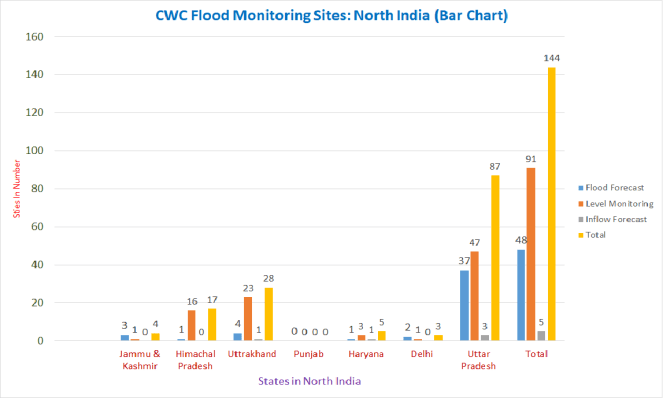
Summary:- Overall there are 144 CWC sites in 7 states of North India comprising of 48 Level forecasting, 91 level monitoring and 6 inflow measuring sites. Out of 144 sites 13 sites are inactive including 11 level monitoring and 2 inflow monitoring. With 87, Uttar Pradesh state has highest number of sites followed by Uttrakhand (28) and Himachal Pradesh (17). There is no CWC station in Punjab whereas Delhi has 3, Jammu & Kashmir has 4 and Haryana state has 5 such sites. Of 11 inactive level monitoring sites 6 are in Himachal, 1 in Uttarakhand and 4 in Uttar Pradesh.
In most of the inflow forecast sites, the full information including level, inflow, outflow through canal, outflow through river is not given. It is also unclear at what stage the inflow forecast is triggered. Even the CWC’s Standard Operating Procedure of flood forecasting this year does not throw light on this, except vaguely stating that this is triggered by threshold values, not mentioning what are the threshold values for different cases.
Table of Level Forecasting, Level Monitoring and Inflow Forecast Sites in North Indian States
| States | Flood Forecast
Sites |
Level Monitoring
Sites |
Inflow Forecast
Sites |
Total | |||
| Active | Inactive | Active | Inactive | Active | Inactive | ||
| Jammu & Kashmir | 3 | 0 | 1 | 0 | 0 | 0 | 4 |
| Himachal Pradesh | 1 | 0 | 10 | 6 | 0 | 0 | 17 |
| Uttrakhand | 4 | 0 | 22 | 1 | 1 | 0 | 28 |
| Punjab | 0 | 0 | 0 | 0 | 0 | 0 | 0 |
| Haryana | 1 | 0 | 3 | 0 | 1 | 0 | 5 |
| Delhi | 2 | 0 | 1 | 0 | 0 | 0 | 3 |
| Uttar Pradesh | 37 | 0 | 43 | 4 | 3 | 0 | 87 |
| Total | 48 | 0 | 80 | 11 | 5 | 0 | 144 |
| Grand Total | 48 | 91 | 5 | 144 | |||
MAJOR GAPS There are major gaps that we can see in CWC’s flood forecasting in North India.
- For example, CWC has no sites in Punjab and Chandigarh.
- In whole of Chenab basin that spans across Himachal Pradesh and J&K, CWC has no sites.
- Even in Sujlej, Ravi and Beas basins, CWC has no flood forecasting sites.
- In Sutlej and Beas basins, it has some flood monitoring sites, but in Ravi Basin, CWC does not have a single monitoring site.
- In whole of Uttarakhand, CWC has no flood forecasting sites in Bhagirathi, Ramganga, Sharda or Yamuna basins. The only Level Forecasting sites it has, are two on Ganga and one each on Alaknanda and Mandakini sub basins.
- In whole of Ghaggar Basin, spanning from Himachal Pradesh through Chandigarh, Punjab, Haryana, and then beyond North India, CWC has no sites at all. This basin suffered huge floods less than a decade ago.
There are many other issues with respect to the actual flood forecasting and monitoring by CWC and its website, which are not dealt here.
A SANDRP analysis (ht.sandrp@gmail.com)
To see such zone wise overviews of CWC Flood Forecasting Sites, kindly visit
Overview of CWC’s Flood Forecasting Sites 2018: North East India
Overview of CWC Flood Forecasting Sites 2018: East India
Overview of CWC Flood Forecasting Sites 2018: West India
Overview of CWC Flood Forecasting Sites 2018: South India
Overview of CWC Flood Monitoring Sites 2018: India
End Notes:
- The sites shown with RED colour are inactive and the sites which have no WL, DL, HFL data but have active Hydro Graph are mention with GREEN colour.
- Abbreviations List:
Warning Level- WL
Danger Level- DL
Full Reservoir Level- FRL
Maximum Water Level –MWL
High Flood Level- HFL
Meters- M
[I] This site is in Uttarkashi on Hamuman Ganga.
[II] Only current water level is showing in Hydrograph.
[III] 222.3 M is mentioned as WL & 223.3 M as DL, HFL on 18-06-2013.
[IV] http://cwc.gov.in/main/downloads/SOP_Flood_Forecasting_April2018.pdf
[V] 338.9 M is mentioned as HFL on 17-06-2013 in data flow map
[VI] Taken from Palla flood monitoring station of Delhi Govt.
[VII] The SOP document gives warning level for Kanpur at 113, but the FF site gives it as 112 m.
[VIII] There are 3 more sites Phaphamau, Allahabad (Chhatang), ALLAHABAD with same WL, DL, HFL in Allahabad
[IX] There is on more site Moradabad with same WL, DL, HFL on Ramganga. It is inactive.
[X] There is one more site Rae Bareli Duplicate with same WL, DL, HFL detail. It is shown on Ganga river and is inactive.
[XI] Hydrograph is not showing Inflow Outflow.
[XII] Inflow is shown and not the outflow.
