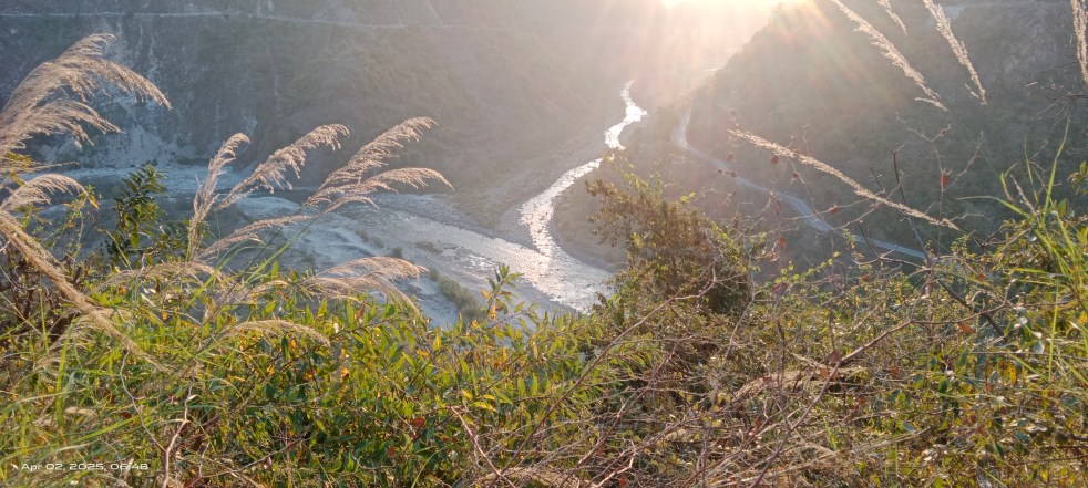
Dams · Hydro Disaster

Uttarakhand 2021: Cloud Bursts around Vyasi HEP

On August 25-27, 2021 the most of hilly districts in Uttarakhand witnessed intense rainfall events causing widespread destruction. Media reports and local people suggest at least seven cloud burst incidents occurring in quick succession over Binhar range in Pacchawadoon and Mussoorie hills dividing Ganga and Yamuna basins in Dehradun district. The resultant deluge has also affected the under construction Vyasi Hydro Electric Project (HEP) areas in Vikas Nagar tehsil highlighting that the project is unprepared to cope with existing & emerging disasters.

Continue reading “Uttarakhand 2021: Cloud Bursts around Vyasi HEP”
Dams · Landslide

JAJRED perennial landslide in Yamuna basin, Uttarakhand

Banner image Jajred landslide zone which just reactivated with commencement of monsoon rains. (Nishant Panwar, July 07, 2020) 

Come monsoon and the Jajred mountain in Kalsi tehsil, Dehradun district in Uttarakhand starts falling apart. Located about 11 km away from Kalsi town, the landslide site near Amraha village blocks the vehicular movement on Kalsi-Chakrata state highway running through the zone for weeks sometimes for months.

This is a routine affair during monsoon for past many years damaging about 250 metre road stretch frequently thus cutting off the hundreds of villages in Jonsar-Bawar area from tehsil and state capital.

Continue reading “JAJRED perennial landslide in Yamuna basin, Uttarakhand”

Dams · Sand Mining

Himachal Pradesh sand mining 2020: No Replenishment study, district foundation

Himachal Pradesh is a hilly state where large scale, mechanized mining of riverbed minerals has been going on for past many years. The damaging impacts on rivers, streams and dependent communities are evident and on the rise. However the state government has failed to bring any change in the scenario as can be seen in this overview covering the related developments during 2019-20.

Continue reading “Himachal Pradesh sand mining 2020: No Replenishment study, district foundation”

CWC - Central Water Commission

WEST INDIA: Overview of CWC Flood Forecasting Sites 2019

Central Water Commission (CWC) is the only agency doing flood forecasting in India. This article attempts to present an overview of CWC’s flood forecasting and monitoring sites in West India. It includes state wise list of CWC’s Level Forecasting, Inflow Forecasting and level monitoring sites in 5 States in West India: Rajasthan, Gujarat, Maharashtra, Madhya Pradesh, Goa. Similar report has been published for North India[i] and North East India[ii] and East India[iii]. A similar effort was made last year which can be seen here: Overview of CWC Flood Forecasting Sites 2018: WEST INDIA. 

Continue reading “WEST INDIA: Overview of CWC Flood Forecasting Sites 2019”

Sand Mining

Illegal Sand Mining Violence 2018: at least 28 People died across India

Across the country, many government officials were killed while taking action against illegal sand extraction in 2018. So were the lethal attacks on reporters and citizens for exposing illegalities and objecting to illegal mining activities. Many innocent people lost lives in accidents related to illegal sand mining related incidents which could have been avoided. This compilation of sand mining related incidents also highlights how illegal sand mining was damaging the infrastructure providing essential services.

NORTH INDIA

Uttrakhand A 115 years old British era bridge on Tons river in Birpur, Dehradun collapsed on Dec. 28 reportedly due to overloaded sand trucks. Two people were killed[1] in the accident. The single lane bridge was damaged during 2013 floods and opened for public after repair. 

Continue reading “Illegal Sand Mining Violence 2018: at least 28 People died across India”

Dams · Floods

Overview of CWC Flood Forecasting Sites 2018: North India

Flood forecasting is an important activity during monsoon, considering the huge and increasing flood prone area, flood frequency, extent and flood damages. Accurate and timely flood forecasting can hugely help reduce the damages due to floods. Central Water Commission (CWC) is the only agency responsible for flood forecasting in India. To understand the CWC’s flood forecasting better, we have compiled the list of the various flood, inflow forecasting sites and flood monitoring sites in India.

In this compilation, we have given state wise list of CWC’s flood forecasting, flood monitoring and inflow forecasting sites, along with available details like rivers, sub basin, river basin, Warning level, Danger Level, High Flood Level, Full Reservoir Level, Maximum Water Level. As we see below, there are many gaps in this basic information for the sites that are part of CWC’s list.

Continue reading “Overview of CWC Flood Forecasting Sites 2018: North India”

Dams

Madhya Pradesh Rivers Profile

About Madhya Pradesh

The state of Madhya Pradesh (MP) was bifurcated in the year 2000.  The total area of MP state is 3,08,245 sq. km. The state has been divided into 50 districts and 342 sub districts. The total human population of the state is 725.97 million. (2011 census) with a decadal growth rate of 20.3%. Key centres of growth are around the urban centres of Gwalior, Indore, Bhopal and Jabalpur.

Climate

It has a subtropical climate. Hot dry summer extends from April to June followed by monsoon from July to September and winter months (November to February) are cool and relatively dry. The average rainfall is about 1,370 mm and it decreases from east to west. Summer mean maximum temperature rises to about 42.5 deg C in northern parts and the average temperature during winters is as low as 10 Deg C again in the north while it varies from 10 – 15 deg C in the south. (Source: Gosain et al in Climate Change in Madhya Pradesh: A Compendium of Expert Views – II)

Continue reading “Madhya Pradesh Rivers Profile”

Dams

Himachal Pradesh Rivers Profile


About Himachal Pradesh  

5 river basins; Total Area: 55,000 square kms.; Total Population: 68.65 lakhs; Total Catchment Area of 5 rivers; Total Catchment Area: 53311 sq.kms

Himachal is a relatively small state and in 2011 its population stood at 68.65 lakhs. It is only 9% urbanised and most of Himachal lives in its villages. Of the total land geographical area only 10% is under agriculture while close to 70% in under the category of ‘Forest land’. And yet agriculture is the main source of livelihood in Himachal with over 93% of the population dependent on it. As in most mountain areas agriculture and forest dependence is interwoven.

Agriculture is made possible due to the irrigation from river channels or natural springs. The health of the forests directly determines the health of the surface and ground water systems which in turn determines the viability of agriculture and horticulture. Horticulture and cash based agriculture was pushed by the government in the late 70s and 80s. Today the state has massive apple cultivation, apart from commercial vegetable cultivation, which is an important source of income for the farmers.

Continue reading “Himachal Pradesh Rivers Profile”

Dams

Uttarakhand Rivers Profile

About Uttarakhand 

Geographical Location- North India largely mountainous with two plains and two partly mountain districts in  the south; Area- 53483 sqkm; Population- 10.12 million; River basins- 4 River basins (R. Ganga‘s basin is subdivided in the map below into R. Bhagirathi, R, Alaknanda and R. Ganga sub-basins); Districts-13; Climate- Sub-tropical to tundra 

About Uttarakhand Rivers

Uttarakhand_Drainage_map

The water quality of Uttarakhand‘s rivers is basically good, especially in the upper reaches. Downstream of some large settlements and in the lower reaches in the Himalayan foot hills the water quality suffers due to the release of untreated sewage and industrial effluents. But the state‘s ambitious program to build 450 hydro power projects threatens the survival of the river ecosystems and the lives and livelihoods of people who live  in these river valleys.

Continue reading “Uttarakhand Rivers Profile”