Maharashtra

Vijay Pandhare’s letter to Dr. Chitale: “Please fix responsibility of the irregularities”

It has been reported that the Special Investigation Team under the Chairpersonship of Dr. Madhavrao Chitale has submitted its 1300+ pages report on the Dam Scam and practically no increase in irrigated area in Maharashtra, to the Chief Minister.

Dr. Chitale has reportedly said that no political person has been named in the report, supposedly because it was not the mandate of his committee. In his words: “There was no question of mentioning the name of any minister or bureaucrat for the wrongdoings in irrigation sector as it was not permissible under the given guidelines. At the very beginning, it was made clear that findings will be very impersonal. The objective of the committee was never to engage in fault finding of any individual (politicians or bureaucrats) but rather larger concerns related to the systemic lapses that resulted in the cost overruns and allowed manipulation of rules,” 

This, though expected from Dr. Chitale, is entirely incorrect as the TORs to the SIT by the GOM, dated 31st Dec 2012 clearly mention 2.9: “If irregularity is found in investigations, the committee will fix responsibility and suggest further action.” in addition, the systemic lapses that have occured in Maharshtra have been sytematically abetted by many for personal gains. Not even attempting to fix the responsibility,is akin to giving a clean chit to the strong perpetrators.

The SIT report is not in the open domain as yet, but if it has indeed shied away from specifically naming guilty politicians, bureaucrats and engineers, then it is hugely problematic. The links between politicians, bureaucrats and engineers have been made clear by a number of whistle blowers of the irrigation scam at grave personal risks. The SIT had all the resources, the mandate, the time and the opportunity to investigate charges and radically influence Maharashtra’s irrigation sector. But right from the beginning, the SIT refused to look into matters of corruption, clearly indicating that it will not ‘dirty its hands’ and will go with the status quo, which suited the ruling government. Supporting Status Quo at such important juncture comes at a huge social cost. SIT’s composition as well as its stand was challenged by many, including SANDRP. (SANDRPs Press Release, Piece by Pradeep Purandare, New Reports, Pani Dhoran Manch PR)

One of the most significant whistle blowers of the Dam Scam, Vijay Pandhare, who was then the Chief Engineer of Irrigation Dept had written a scathing letter to Dr. Chitale in March 2013, when Chitale refused to investigate any evidence given by leader of opposition Vinod Tawde about corruption in the Irrigation sector.

This letter ( obtained and translated from Marathi into English by SANDRP) indicates Pandhare’s impassioned appeal to Dr. Chitale to investigate charges and fix responsibility as per the mandate of the committee.  Pandhare in fact says that: “If the SIT is going to be escapist about the issue of corruption, then it is better that you resign, listening to your inner voice, because such escapism would not be in the interest of the state.” He produces many evidences of wrong doings in the WRD. The scale of the problem described in the letter is staggering. We look forward to how these matters have been treated by the SIT Report.

Parineeta Dandekar, SANDRP

VIJAY PANDHARE WRITES TO DR. MADHAV CHITALE, MARCH 2013

 From: 

Vijay Balawant Pandhare

Chief Engineer,

Maharashtra Engineering Research Institute, Nashik, and

Member, State Technical Advisory Committee,

Nashik- 422004


Dt- 16th March 2013

To,

Shri. Madhavrav Chitale,

Chairman,

Special Investigation Team,

WALMI, Aurangabad

Subject- About inquiry into technical and financial discrepancies in Water Resources Department of Maharashtra


Respected Sir,

Regarding the subject sited above, it is learned through news reports of 6th March 2013 and through the broadcasts of Marathi news channels that, you have wrote to the Leader of Opposition Mr. Vinod Tawade stating your committee is not empowered to inquire officers and political representatives.[1]

In fact, while determining the mandate of your committee TORs explicitly mention “fixing the responsibility against any discrepancy and suggesting suitable action against it”.[2] The government has clearly mentioned in your mandate that “fix the responsibility against the discrepancy”. So, your stand that the Special Investigation Team (SIT) doesn’t have any investigating power is against this mandate. It is like Lord Ram deciding that he will not attack the evil spirit or will not oppose it. If you are not going to unmask these corrupt spirits through the special investigation team, would we have the moral right to seek respite from Lord Ram? Moderate and honest people like you are required to lead the bandwagon against such corrupt people and dishonest mentality. Such an opportunity is created because of the constitution of SIT. We believe that you would capitalize on it. ( Emphasis added, throughout the letter) The anarchy created in Water Resources Department is because of the non-functional office-bearers. If the officers would have been alert and selfless, such a catastrophic situation would have never come, however, it has been difficult in our times to see good officers rising through the ranks. It seems that picture would be very gloomy from here on. Therefore, it is your first responsibility to identify people who are responsible for such a situation, those who have created discrepancies and fix the responsibilities. After outlining the mandate, the state government has thrown a ball in your (SIT) court. Therefore, it will not be acceptable to adopt a stand which turns a blind eye towards all of these malpractices. The government has nowhere said that the committee has not investigative powers. The very name of the committee itself is a “Special”. Isn’t it contradictory to take up such a stand when the committee itself is called “Special Investigation Team” then? On the other hand, the committee should ask for complaints from all the people and investigate them all. But your stand seems to be something else altogether. Please don’t continue with that. (Emphasis added). There is no prohibition on any committee for accepting complaints from the people and collecting sufficient information pertaining to the investigation. If the committees like Vadnere, Kolwale, Mendhegiri etc. can determine the responsibilities on the defaulters, why can’t the SIT under Mr. Chitale?[3]

Earlier officers never took a firm stand against such malpractices which eventually culminated to degradation of Irrigation department. The responsibility of improving the situation has been entrusted with your team, otherwise, history will never forgive us. If the committee is going to be escapist about the issue of corruption, then it is better that you resign , listening to your inner voice, because such escapism would not be in the interest of the state. I can understand (although don’t justify) the attitude of political representatives about the scam, but honorable people like you need to take a strong stand to make the department disciplined. Im sure that escaping from this duty and saying that Pseical investigation team does not have the power to investigate is not something that your conscience would agree with. Despite that, your statement regarding Tawade’s letteris a clear indication that the team would shy away from such investigation. To improve the situation in Irrigation department, some surgical measures should be taken otherwise the financial crisis of the state would persist in the foreseeable future. I want to remind you that around 14-15 years back we personally met in Aurangabad and I had told you how pathetic and corrupt the administration has become. That time too, you had said that the political representatives have taken charge of everything and you were resigned in saying that it’s difficult to change the situation. But now the destiny has entrusted you with the responsibility to end these malpractices. We request you to please carry it out with the help of Mr. Ranade. It would be very unfortunate for Maharashtra if you are not going to fix the responsibilities against the observed malpractices, something which is clearly in the mandate of your team. If the projects are not getting completed even after 25-30 years, isn’t it a serious blunder by the policy makers? Shouldn’t we fix the responsibility ? Is it not sinful to float tenders, make payments against inflated costs, financially weaken the state and push people into drought situations? If you’re not going to prevent such practices, then who will? I was extremely surprised to learn about your stand. If you really want to serve for the betterment of Maharashtra, then taking a strong stand against such practices so that nobody would dare to tread this path is very much expected from you. If we all decide, then we will have “Ram-rajya” in our country. But if we are moving away from Lord Ram’s ideals, we have no turn to him for the help. (Emphasis added)

I’m enlisting the discrepancies that I observed while working in Water Resources Department. Kindly investigate them and fix the responsibilities against the defaulters so that nobody would ever dare to indulge in such practices.

Discrepancy No. 1-

Without investigating or envisaging properly, irrigation development corporations have approved budgets with inflated costs and have granted tenders at higher price to the contractors. This has resulted in wastage of billions of rupees of public funds. We request you to thoroughly investigate all the discrepancies and fix the responsibilities. So that, no political representative or contractor or engineer would ever indulge into it.  If no inquiry is conducted, these people would keep looting the state as well as nation with boosted confidence. That’s why the honest and selfless people should try to prevent such malpractices otherwise it is beyond doubt that our coming generations, our nation and the democracy will have a dark future.

For example, please note the projects in Tapi Irrigation Development Corporation-

  1. A.      Sulwade Lift Irrigation Scheme (Cost ₹ 2100 Cr)
  2. B.      Bodwad Lift Irrigation Scheme ( Cost ₹ 2200 Cr)
  3. C.      Prakasha-Burai Lift Irrigation Scheme (Cost ₹ 700 Cr)
  4. D.      Varangaon-talwel Lift Irrigation Scheme
  5. E.       Padmalay Lift Irrigation Scheme
  6. F.       Kurha-vadoda Lift Irrigation Scheme

Like these, thousands of tenders have been awarded. It is requested to permanently stop such cases.

Discrepancy No. 2

The projects that have been approved by respective development corporations have always witnessed increase in their scopes. You can find many such projects. White paper enlists such modifications under each scheme. Such modifications/ increments have been approved without giving proper thought to their impacts and hence these projects are bound to fail. Because, the projects which have been approved at inflated costs get less funds allocations and eventually results in the projects remaining incomplete for more than three decades and there is no way these projects would be complete in next 30 years either. Therefore, the officers and politicians who approved such changes should be held responsible for these discrepancies.

Discrepancy No.3-

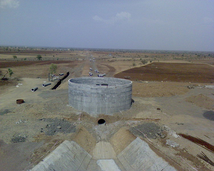
The way in which each development corporation has cited their cost break-up would stun anyone. It is clear that the interests and the benefits of the contractors have been secured by employing multiple tricks. It has been a very common trend in Konkan and Vidarbh Irrigation Development Corporations. Other corporations are not an exception either. The episode of the inflated costs paid against the steel pipes in Jigaon Project Lift Irrigation Scheme is indeed well-known. Vidarbh Irrigation Development Corporation itself has cancelled ₹ 2900 Cr tenders because those were based on such inflated costs. We request the SIT to investigate such discrepancies in the budget of the said projects. To prevent such incidences from happening again, such incidences should be thoroughly investigated and defaulters must be brought to the book. Please investigate the cost sheets of following items-

  1. 1.       Hearting and casing items
  2. 2.       Pitching items
  3. 3.       Rising main and steel pipe items in lift irrigation schemes
  4. 4.       Radial gate fabrication rates
  5. 5.       Dewatering items, excessive dewatering
  6. 6.       Concrete and masonry items

The SIT should also probe the various reasons cited for increasing the costs.

Discrepancy No-4

There have been humongous discrepancies in the “C” grade tenders. In most of the cases, despite being “C” level tender, “EIRL”s of hundreds of thousands of rupees have been passed and even the claims have been settled too. Therefore, it is necessary to investigate all the EIRLs and claims against them from all the development corporations. The SIT should ask for information in a tabular form about all the EIRLs and respective settled claims from all the irrigation development corporations, and probe the serious cases. Otherwise there would be no check on such malpractices.  For example, I’m referring to the Nardawe project EIRL here. Despite being a “C” tender, KIDC (Kokan irrigation Development Corporation) has granted EIRLs worth ₹ 30-40 Cr. Moreover, it has also settled the claims for machinery idle charges without taking due permission from the state government. Due to less availability of funds, the contractors have made it a trend to show that their machinery have been idle on paper and have been receiving the idling charges. Big projects have been approved with administrative approvals and now idling charges are being paid citing the unavailability/ insufficiency of funds. Projects are incomplete for years because of unavailability of funds and according to price escalation clause of the tenders, hundreds of thousands of crores are being paid to the contractors. The situation is so grim that the actual expense incurred on work is marginal and that on price the escalation is multifold. For example, let’s see the Sulwade Lift Irrigation Scheme of Tapi Irrigation Development Corporation. Work order was granted 14 years ago. Because of unavailability of funds, ₹ 15 Cr have been spent on the actual work. However, during the same period, the price escalation has been of ₹ 700 Cr! There are many such projects which have not begun in last 14 years. The responsibilities of such agonizing planning must be fixed on responsible people.

Discrepancy No. 5-

The earthen dams which are being constructed under B-1 tender, exhibit “excessive” cross-sections while the works under “C” tender have “under-sized” cross sections. Engineers from Central Design Organisation:  MERI must have had a hand in this. This is commonly known but nobody talks about it. The best example of how these engineers from the mentioned organizations have given wrong design is of Radial gates. The variations made for the same sized radial gates are worth visiting. The radial gates size of Gosi-khurd, Shelgaon barrage, and Lower Tapti projects are same. In fact, their weights should have been more or less identical. But, their weightages have been absolutely irrational. Weightage of Lower Tapti is 208 MT/Gate but that of Gosikhurd has 159 MT/ gate weightage. This one example is sufficient. The weight of steel has been increased by around 1000 folds. To stop such things, SIT should give special emphasis on such practices and prevent their repetition.  Against this backdrop, Konkan, Krishna valley, Tapti, Godavari and Vidarbha Irrigation Development Corporations should be thoroughly investigated. Nardawe project of KIDC has two Cut of trench (COT). Such technical irregularities have been followed which must be stopped. The investigation of Balganga project would yield many shocking cases. It would be interesting to check how much cement grouting and expenses have been incurred to stop the leakage of Bhatsa project.

Discrepancy No.6.-

There have been numerous attempts in Maharashtra to raise the height of the dam wall. The existing dams do not get completely filled in the first place. Despite that, the department has consented to raise the dam wall height in hundreds of dams. Raising height has always been an expensive affair which has resulted in increased expenses. It has been a norm with Maharashtra’s Irrigation Department that anybody would ask for raising the height and the department would float the tender.  Considering the availability of funds with the state, contemplative policy makers would not have indulged in such things. But the unwise leadership has encouraged such attempts and dealt a permanent damage to all of us. It is clear that receiving cuts (percentages) against floating tenders has been a common norm here. If you would enlist the projects which witnessed such height raising, the SIT would understand the irregularities.

Discrepancy No. 7-

Many high cost and unviable projects have been undertaken/ are proposed to be undertaken under the name of increasing irrigation. When there has been no feasibility on the site, is there a case for floating high cost budget? While we have shortage of funds, such expensive affairs would not have been advisable. But some political representatives and engineers have made us bankrupt. I’m enlisting few projects here, the SIT should probe into them-

  1. 1.       Manjarpada Project Phase 1, Nashik
  2. 2.       Nerdhamne Project- Akola
  3. 3.       Shahapur Project- Akola
  4. 4.       Waghadi Project- Amaravati
  5. 5.       Chandrabhaga Project- Amaravati
  6. 6.       Kawatha Project- Amaravati

Despite the financial crunch in the state, nobody has bothered to talk sense into the cost estimates. How could we ever adopt the projects worth ₹ 15, 10, 5, 4, 3, and 2 thousand crores? The SIT must probe into this. It shows the prevalent mentality of satisfying political agendas from public funds and siphoning it off as much as possible. It is our responsibility to uproot such mentalities. Otherwise the democracy will not survive. We will see selfish anarchy rising in our country. We have come a long way from selfless leaders like Gandhi- Nehru to our current tender-floater leadership.

Discrepancy No-8

There is an urgent need to probe the tunnel works being done in Krishna river valley. There have been many tunneling works undertaken in Krishna valley without any rational basis. If one checks the rate analysis of all the excavation work, the rates would appear to have been inflated. There have been many big tunnels undertaken instead of small ones. It is a common practice to float the tender with small sized tunnels and increasing the size of the tunnel later on. SIT should probe into the works undertaken for all the tunnels so that such mistakes won’t be repeated. If the team would investigate the tunnel works in Manjarpada-1 project, such practices would be unmasked.

Discrepancy No.-9

Many projects have been granted water availability certificates from the जलविज्ञान कार्यालय (Hydrology Project) of the government as a special case, which are violations of law. The SIT should make a list of all such cases and probe them to avoid repetitions. Despite the lack of water, projects are undertaken and then they never fill up for years together. Painaganga valley has seen several such examples and still, the water availability certificates have been granted 1.5 times more than the actual water availability on ground. We request you to investigate them all.

Discrepancy No 10-

There has been no master plan for any of the irrigation development corporation approved at the government level. In absence of approved master plan, the projects have been pushed forward. We would not have been in such an unfortunate situation if the state government would have prepared a master plan and then adopted the projects accordingly. Policy makers and secretary level bureaucrats are responsible for not approving such a master plan. There is a need to fix the responsibility of this irregularity and the government must plan its irrigation-related works according to a master plan. But some political leaders don’t let this happen because they want to earn unfair profits out of it. Kindly suggest a measure which would permanently do away with this malpractice.

Discrepancy No 11-

There has been an unfortunate trend in Maharashtra of showing a new project as a part of old project on the papers and floating the tenders without taking administrative approval. Hundreds of projects have been undertaken in such a fashion. SIT should ask for the information from all the development corporations and fix the responsibility of respective irregularity. 12 barrages of Godavari, Manjarpada 1 project could be cited for example. Therefore, we request you to suggest a permanent solution against this malpractice.

Discrepancy No. 12-

It is such a shame that the projects are not being completed for 20-40 years. It reflects our poor thinking and planning. We need to put a cap on the budgets of the projects. The planning should be such that any project must be completed within 5 years. We should stop the costs of projects running as high as ₹ 5, 10, 15 thousand crores. If the political leaders from the areas of Takari, Mhaisal, Tembhu lift irrigation schemes have not been able to complete these projects despite being in power, when would the projects of other areas be completed? The team must contemplate on this and create a work discipline in Maharashtra. Kindly fix the responsibility for taking so many lift irrigation schemes when not even 1% of the 300 schemes undertaken by the irrigation department are operational. Kindly suggest the measures for future so as to prevent the wastage of public funds.

Discrepancy No. 13-

There have been many irregularities in Mechanical department (यांत्रिकी विभाग) of Water Resources Department. Vigilance cell has received many complaints. Executive engineer, vigilance team, Pune has submitted the report to the government saying there have been humungous irregularities in the Mechanical wing. I request to inquire into it so that there would be a discipline within the mechanical wing. Nobody is paying attention to irregularities in that division.

Discrepancy No. 14-

There has been no provision for technical audit in the department. Therefore, there has never been a verification of technical matters. To prohibit people from indulging in technically flawed work, it is requested to start a technical audit on the basis of AG. Therefore, there would be check on technically flawed decisions. All planning has collapsed because of the wrong estimates.

Discrepancy No 15-

Currently the state government doesn’t supply the cement for the project works, contractors buy it on their own. Therefore, the department has lost control on cement usage. There has been a tremendous corruption in cement related matters. The main reason behind stopping the supply of cement has been that the contractors find it difficult of sell the cement after the work is done. However, no irrigation development corporation has ever undertaken the thorough check up of delivery challan and excise gate passes as per the tender conditions. Therefore, there is a huge corruption in cement usage. SIT can easily prove it. There would be a shocking revelation- and it should come out- if once checks the used cement, verified delivery challans and gate passes. Every engineer knows it but they prefer to keep quiet. But, SIT should probe this and fix the responsibilities. 23 km long lining of Gosikhurd Left Bank Canal has been completely taken out because of the poor quality. The reports of executive engineers of Maharashtra Engineering Research Institute (MERI), exposing the poor quality of work done in Lower Tapi and Tarali have been suppressed. Please at least stop this corruption by supplying cement to contractors. People would be grateful to you if you could do that.

Discrepancy No. 16-

There have been too many irregularities in the irrigation department under the name of Arbitration. A closer look at all the cases of arbitration would surface these irregularities and malpractices. Especially in Marathwada, Pune, Konkan divisions and more so, in Koyana project, the corruption has been many folds. The arbitration has been the best example of how the officials indulge in corruption instead of taking the decisions in the best interest of the country. Therefore, there is a need to re-audit all the arbitration cases. Please suggest strong measures to prevent such things from happening again.

Discrepancy No. 17-

Right now, the IPI circles are almost equal to none in the water resources department. Therefore, the contractors themselves prepare the budget estimates. They prepare the estimates as they please, get them approved using political pressures and siphon off the public funds. That’s a norm! This has to stop immediately and the department must newly create IPI circles in each regional department. Isn’t it obvious to the government? To the political representatives? But they all have deliberately made those mistakes. I request to find the defaulters in those cases.

Discrepancy No 18-

Earlier the state also used to provide steel to the contractors. But now contractors themselves buy the steel. Like cement, the department has lost its control on steel usage and the risk of re-rolling steel being used in the work has increased. This is indeed serious. Therefore, it is requested that the steel should be supplied under Schedule-A like before. People who have taken such wrong decisions must be identified along with their faults.

Discrepancy No. 19-

I also request you to probe into all the steel gate fabrication works done by contractors for the rates of fabrication. In Jigaon Lift Irrigation Scheme, the fabrication rates- like the steel pipe rates- have been divorced from reality. If you would check the gates on Tapi, you can realize how the costs have been inflated. If all the irrigation development corporations are asked to submit the steel fabrication rates, irregularities of crores of rupees would be exposed.

Discrepancy No 20-

There has been a tremendous corruption in all the corporations under the clause 38 and claims. Therefore, it is requested that all the clause 38 and claims cases of all the corporations be investigated. One would be surprised by the subsequent revelation of how the costs and respective works are inflated. It is worth investigating how the officers and politicians have joined hands to commit “mistakes”. Engineers know the kind of pressure and tensions faced by the good officers who were opposing these decisions. Everybody knows how the people opposing it were insulted. These incidences are common in KIDC and so also in other corporations. Those should be investigated.

Discrepancy No. 21-

Cost of many items has been inflated beyond comprehension in all the corporations. It would be really an eye-opener exercise to check how the revised administrative approvals have been granted year-wise. For example, if you would compare the earlier tenders with the budget estimates in the Tapi Irrigation Development Corporation, you would easily find the irregularities. They have been happening all over. The rates have been inflated tremendously. Comparing the rate analysis method that was adopted before 1980 and the one in effect now would prove it. By use of machines, the rates should have actually gone down but they have been raised by deploying various tricks. Investigating in such cost escalation and finding the defaulters is the need of the hour so that nobody would ever dare to indulge in such malpractices.

Discrepancy No 22-

The tenders have been awarded with high costs across all the corporations. If the true competitive bidding would have taken place, the tenders would have been awarded with 25-30% lesser rates and the works would have also been done because the rates of the rate index were higher as well. Instead of that the tenders are awarded with the higher percentage. Everyone knows how the tenders are floated at the government level. SIT should probe into all the tenders which have been awarded above percentage. The 3 large bridges which were built by Tapti Irrigation Development Corporation in the submergence area are higher than the current rate index by 60%, 70% and 80%. This is a serious irregularity. Probing into such high cost tenders awarded by all the corporations would yield the serious corruption in public expenditure. That’s why ₹ 2900 Cr tenders had to be cancelled in one go. Such a shame!

The costs of barrages built on Godavari, are raised by constructing a large dam without any reason. This is a shameful waste of money when there has been a financial crisis. Everybody has fallen prey to such hideous plans. All of these actions should be investigated into and the defaulters must be brought to the book.

Discrepancy No. 23-

Some of the irregularities have been brought to your notice. Apart from these, it is requested to you to suggest strong measures to prevent ground level and foundation level scams. Please assign at least three people to cross check such activities. It saddens me to think how much state is losing in all of such scams. But everyone seems to have become insensitive. Those who oppose it are transferred. Politicians don’t even know about technical sins. We need to stop all such mismanagement and misuse of power. The crimes pertaining to such adjustments would be exposed by checking the earlier Cement delivery chalan and gate passes of RA-bills.

Discrepancy No 24-

All the corporations have been routinely floating the tenders for a project based on the designs of other project and later on escalating the costs by several folds based actual design. It is requested that such information be collected from all the corporations and identifying the responsible people so that these irregularities would never occur.

Discrepancy No 25-

The high cost tenders are floated just to siphon off public funds. What can you call this practice- of preparing a budget estimate with hundreds of thousand crores, awarding the tender, spending around ₹ 10-15 Cr only in the beginning against the advance, and then for next 14 years, the project doesn’t get any money while the cost of the project rises from ₹ 600 Cr to ₹ 2100 Cr!

Do you think these projects would ever be complete? The worst cases in this regards are Sulwadi, Jamphal Lift Irrigation Scheme, Prakasha-Burai Lift Irrigation schemes etc. The tenders of hundreds of thousands of rupees of the projects on which less than 25 % of funds have been spent must be cancelled with immediate effect. Instead, the works costing less than ₹ 100 Cr should be undertaken otherwise the state would never come out of the financial crunch.

Discrepancy No 26-

There needs to be a thorough investigation into Takari, Tembhu, Mhaisal Lift Irrigation Schemes. Despite spending crores of rupees in last 25 years, the farmers are not getting water. The responsible people must be unmasked after thorough investigation. The machinery installed 20-25 years ago has its days numbered. Isn’t the expenditure totally wasted? What is the use of the projects which can’t even irrigate 10-15 % of the promised irrigated area? It is requested that kindly compile the information from respective departments and probe into them. Please suggest strict measures about Lift Irrigation Schemes as well. (It is also requested that please investigate Krishna Marathwada Lift Irrigation Schemes, Khuntefal storage lake, Kurha- Vadoda Lift Irrigation Schemes as well).

Discrepancy No 27-

Granting the advance money while there is no provision in the tender has also been one of the unfortunate norms. It is requested to collect the information from the respective corporations and identify the defaulters. For example- Five lift irrigation schemes of the Tapi Irrigation Development Corporation.

Discrepancy No. 28-

All the irrigation development corporations have indulged in floating and awarding the tenders without legitimate surveys and optimum designs. I request you to seek the information on all such cases and find the defaulters. All the “C” Tenders awarded in the state fall under this irregularity. Therefore, please fix the responsibility of such “C” Tenders after conducting due investigations, especially in case of “C” tenders awarded under Krishna valley, Tapti and Kokan irrigation development corporation.

Discrepancy No. 29-

We have many projects in Maharashtra which have violated the I. S. Code norms and received approvals. 12 barrages on Godavari are the best examples of such violations. I would not be surprised if sooner or later these barrages would create some or the other kind of problem. Not taking flood design into account as per I. S. Code, especially in case of river like Godavari, is a serious blunder. I request you to investigate all such cases from respective corporations and fix the responsibilities.

Discrepancy No 30-

All the corporations have been floating and awarding the tenders without completing land-acquisition and rehabilitation of the affected families and obviously projects keep lagging for years together in absence of such important formalities. It is requested to find the responsible people and fix their responsibility

Discrepancy No 31-

It’s an open secret why the files are sent back to cabinet minister for “Liability Sanction” after completing all the due procedures of awarding the tender. The truth would come out if the data-wise investigations are carried in all such cases of liability sanction. Such kind of hegemony never takes place in any of the states in India. Please look into the matter and suggest preventive measures.

Discrepancy No 32-

In most of the estimates about the projects of Konkan and Vidarbha, though the excavation works have been done with the help of machinery, lift schemes are proposed in the rate analysis. So also in cases of pit filling works done using the machinery of hearting. Please summon the respective corporations over such irregularities, ask for the detailed reports and fix the responsibilities on defaulters.

Discrepancy No 33-

The budgets and estimates prepared by all the corporations are never checked/ cross-checked properly and are directly submitted to the state technical advisory committee. All the irrigation development corporations have been indulging into this. Nobody has so far been suspended no matter how many blunders the person committed. So, everyone has become fearless of law and the politicians have become god fathers of such corrupt people. Kindly investigate into all such matters and find the defaulters so that such activities would stop.

I’ve highlighted some of the major irregularities happening in the department. I request the SIT to come out with the measures which would prevent repetition of such things. It is further requested to take away powers to transfer the officers from politicians. The situation would be much different if the politicians are kept out of these transfer mechanisms.

Also, there should be no involvement of politicians as far as tender processes are concerned. The unfathomable corruption in tender processes would stop only if the politicians are kept at bay. Kindly recommend robust measures for that.

Lastly, I beg you for recommending the government to move away from constructing large dams, big canals, huge lift schemes, and budgets spanning over millions of rupees etc. otherwise the situation would never improve.

There is a need to revisit the fundamentals of irrigation schemes and adopt small dams, water conservation measures like Shirpur patterns etc. Large dams should be taken up only in exceptional cases. The situation seems pretty grim considering the large dams, canals, and distribution networks that we have undertaken in last 50 years. We need to check if the area which was supposed to be irrigated, has really been benefited. There is no point in digging wells for the purpose of percolation either. What has happened to the commitment that we had made in the beginning? Its review would prove that our total irrigation efficiency doesn’t even exceed 15%. So please review and revisit our irrigation policies. The state would have had much better irrigation had the Shirpur of such small, appropriate technology patterns had been adopted. Unfortunately the state has suffered the most because of the people with insatiable greed for power and money- be it engineers, or politicians or contractors. The political leaders have stripped the state of all its possessions. Therefore, I beg you to drastically change the irrigation policy. I pray to the ultimate creator that you would change the situation for the betterment of Maharashtra.

It does not matter if the team would need an extension, or if an additional investigation team would be composed, but, please create an order in the state.

Yours,

Vijay Pandhare

Chief Engineer META and

Member, State Technical Advisory Committee

Nashik 4

Attached:

Letter dates 20.02.12 ( 9 pages)

Letter dated 5.5.12 (15 Pages)

Letter dated 12.10.12 ( 4 pages)

Copy to:

Hon. Governor, GOM, Mumbai for appropriate instructions

Hon. Chief Minister, GOM, Mumbai for appropriate instructions

Hon. Chief. Secy, GOM, Mumbia for appropriate action

Hon. Principal Secy, Irrigation Department, GOM, Mumbai

Shri. V. M. Ranade, Retd. Secy and Member, SIT

Translated from Marathi to English by Damodar Pujari


[2] From SANDRP: TORs of SIT , GOM, 31 December 2012, Point No. 2.9 States: If irregularity found in the investigation, it should be investigated, responsibility should be fixed and action to be taken should be suggested.

[3] We have shifted the placing to this para

Arunachal Pradesh · Expert Appraisal Committee

Hydromania in Arunachal Pradesh: Massive 1850 MW Dam Planned Without Any Basic Data, Not even Water Flow Data…

‘MoU Virus’ was the term used by former environment minister Jairam Ramesh in May 2008 to describe the speed at which the Memorandum of Understanding or MoUs for hydropower projects were signed by Arunachal Pradesh government. Five years after that virus attack, the ill-effects are clearly visible. The construction of Lower Subansiri hydropower project has been stopped for 26 months now. Environment and Forest clearances are yet to be accorded to 3000 MW Dibang Multipurpose dam, even though the foundation stone for this dam was laid by none other than the Prime Minister Dr. Manmohan Singh on 31st January 2008. Lower Siang hydropower project public hearing was vehemently opposed by people. But learning no lesson from these, the government of Arunachal Pradesh and the center is going ahead with its gigantic plan to make Arunachal Pradesh the ‘future powerhouse’ of the country. In doing so scientific studies and ground realities have been blatantly neglected.

Oju hydropower project in the Subansiri river basin with a proposed installed capacity of 1850 MW is the latest example of the hydromania, which has gripped the government of Arunachal Pradesh and the center. Oju HEP is the upper most project proposed on the Subansiri river in the Upper Subansiri district with a catchment area of 9827 sq. km. up to the dam site. The project was considered for Terms of Reference (TOR) or first stage of environmental clearance by the Expert Appraisal Committee on River Valley and Hydroelectric projects (EAC) in its 72nd meeting held on 20th and 21st February this year. But there is little information available about the actual situation of the project area.  Before going any further, consider the following situations –

Any scientific study is yet to be done at the dam site. Water flow data which is a prerequisite for construction of a hydropower dam is not available for the proposed dam site. No gauge and discharge measurement site at the project site or anywhere in the catchment of the dam.

The project area is totally under forest cover. It holds rich biodiversity which is yet to be explored.

* There is no road to reach the project area. The distance between the dam site of Oju hydropower project and Limeking town, the last point of motarable road is 60 km. From Daporijo, the headquarters of Upper Subansiri district, the dam site is 210 km away. 

Tentative Road Network to Project Site Source: Oju PFR
Tentative Road Network to Project Site
Source: Oju PFR

A small hydropower project is proposed to be constructed in a nearby stream in order to fulfill the electricity requirement during the construction of the project.  

SNC-Lavalin, the consultants hired for preparation of detailed project report, is known to be one of most corrupt engineering firms in the world.

All the situations mentioned above are drawn from the project documents submitted to MoEF. It was shocking to find that without any environmental baseline assessment, the Pre Feasibility Report and Form I made all kinds of sweeping assertions. This hydromania is leading to nothing but ignorant, unscientific and corrupt decision making. 

SANDRP after reviewing the project documents, made a detailed submission to EAC on February 13th pointing out the critical issues related with Oju HEP. We asked the EAC not to consider the project for TOR clearance. We also demanded that the project proponent should  be  asked  to  get  at  least  five  years’  daily  water  flow, gauge, rainfall and sediment data at the project site before applying for TOR clearance. The critical issues mentioned in SANDRP’s submission on Oju HEP to EAC are listed below.

Critical Issues of Oju HEP

No More Projects Should be Cleared in Subansiri basin before Completion of Basin Study From 20007 to 2013, four projects in Subansiri basin has been considered by EAC along with one sub-basin study. All the four projects have been given TOR clearance. Subansiri Upper HEP has been given TOR extension on 6th June 2013. The total installed capacity of these projects are 4960 MW. It is also important to note that 2000 MW Lower Subansiri project is in under construction phase. This implies that nearly 6960 MW of capacity has already been given clearance by EAC without any cumulative impacts assessment study of Subansiri basin being completed through a participatory process. This capacity is in addition to the small hydropower projects in the basin.

The Subansiri sub-basin study was discussed for the first time in 68th EAC meeting in 2013. In that meeting the EAC had stated that “optimal number and locations of HEPs and similar projects to be planned in the basin conforming strictly to ecological and environmental sustainability is to be clearly delineated.” This can only be known once the basin study is completed.

In this situation, no more projects in Subansiri basin should be given any clearance till the cumulative study is being completed. Besides, the EAC must take into account the fact that cumulative impact assessment study of the basin is major demand of the organizations whose agitation has stopped the construction work of Lower Subansiri with the support of the people of Assam. Therefore it is very essential that a through and detailed cumulative impact assessment study is done for Subansiri in participation with all the people of the basin. Without this, clearances given to projects would face the same fate as the Lower Subansiri project is now facing: Work stopped for 26 months till now.

A list of projects cleared by EAC in Subansiri basin is given below.

Sl. No Project State Sub-Basin Ins Cap Status Meeting date Total Area Req. ha Forest Land, ha
1. Subansiri Lower AP Subansiri 2000 Under construction EC on 16-07-03 4111 4039.9
2. Subansiri Middle AP Kamla 1600 TOR Approved 25-09-10 3180 1333
3. Nalo HEP AP Subansiri 360 TOR Approved 11-12-11 662.94
4. Naba AP Subansiri 1000 TOR Approved 03-05-13 658
5. Subansiri Upper AP Subansiri 2000 TOR Ext Granted 06-06-13 3155 2170

Premature application Reading the PFR and Form I on the EAC website shows that project has come rather prematurely for TOR clearance. There is no gauge and discharge measurement site at the project site or anywhere in the catchment, the nearest site is at Upper Subansiri dam site with catchment area about 50% higher than that of Oju HEP. Even for this site, the flow measurement observations are available only for 6 years. How can optimum parameters of a massive project with 1850 MW capacity be formulated without any flow measurements, which is the most important parameter for hydropower project. Even now the flow measurements do not seem to have begun. There are no roads to the project area. It should be remembered that this is a virgin site, and there have been no environmental baseline assessments and yet the PFR and Form I are making all kind of sweeping assertions. The PP should be asked to get back with such an application only after they have at least five years of observation data of water flow and other parameters. That the application is premature is also apparent from the drastic changes the project capacity has gone through so far, as described in PFR. 

Oju HEP's nearest gauge is located in Menga, also the site for Subansiri Upper HEP. But there are four hydropower projects planned between Oju and Subansiri Upper.  Source: Form I of Oju HEP
Oju HEP’s nearest gauge station is located at Menga which the site for Subansiri Upper HEP. But there are four hydropower projects planned between Oju and Subansiri Upper. Source: Form I of Oju HEP

This premature-ness of the proposal is further confirmed when we see contradictory figures in the submitted documents about basic project parameters. For example dam height is given as 110 m (sec 8) at one place and 115 m at another place. Live Storage capacity is given as 2.065 MCM at some place, 3.3 MCM elsewhere (e.g. sec 4.4 of PFR). Power intake design discharge is given as 327.4 cumecs at some places and 333.39 cumecs elsewhere (e.g. sec 2.2 of Form 1).

Proposal in contradiction with Cumulative Impact Assessment This proposal before EAC for a 1850 MW Oju project is in contradiction with what is given in the Cumulative Impact Assessment (CIA) commissioned by the CWC and which was discussed in the 68th meeting of  EAC. The CIA says (see para 3 of Ex Summary) that there are two Oju projects: “Oju – I (1925 MW), Oju – II (2580 MW)”. However, the proposal now before the EAC is one project with capacity lower than any single project! However, Table on page 15 of CIA says Oju I has 700 MW and Oju II has 1000 MW capacity! The CIA says the submergence area of Oju I is 72.3 ha, though the proposal now before EAC for the same dam says the dam has submergence area of 42.3 ha! CIA says design flood is 10500 cumecs for Oju I (same dam as Oju now before EAC), but the proposal before EAC says PMF is much lower at 5983. This shocking series of numbers show that both the reports of Oju project before EAC and the CIA are misleading and do not seem to know what they are talking about. This is not an exhaustive list of contradictions, there are many more, this is only for illustration. 

Map of Subansiri RIver Basin  Source: https://sandrp.in/basin_maps/Subansiri_River_Basin.pdf
Map of Subansiri RIver Basin
Source: https://sandrp.in/basin_maps/Subansiri_River_Basin.pdf

Proposal different than allotment The PP was allotted two separate projects Oju I and II by Arunachal Pradesh government, but they have decided to club the two, but there is no agreement between Arunachal Pradesh and PP for the new parameters in the project proposed before EAC. Without such an agreement, EAC consideration of the project would be vacuous.

Huge Land Requirement The Form I of Oju project states that the area which will come under submergence due to the formation of the reservoir excluding the river bed is 34.3 ha. Including the river bed the total submergence is 43.2 ha. But the total land requirement is 760 ha implying that the required for dam, water conductor system, power house and other project appurtenances is about 727 ha. It is not clear why 760 ha of land is required for the project when reservoir submergence is 43.2 ha.

Contradictory figures about Land Requirement The Form I in the table providing basin information about the project states that “The total land to be acquired for the project is 760 ha.” But the PFR in section 12.2 in page 15 states “It is estimated that about 790 Ha of land would be required for development of the Project.” This shows that the project proponent is not clear about the land requirement for the project. 

Threat to Huge Forest area The construction of Oju HEP will be a threat to a huge forest area. Page 17 the Form I states “…760 ha of land with forest cover is to be acquired for the project. Forest cover is also observed within the project as well as area within 15 km from the project site.” But the PFR does not specify how much forest area will be actually diverted. 

River Subansiri flowing through its lush green valley

Installed Capacity is more than 1850 MW The installed capacity of Oju project is more than 1850 MW since a dam toe power house of 28 MW is also planned. This makes the total installed capacity in 1878 MW. The documents in most of the places mentioned installed capacity of the project as 1850 MW. The EAC therefore should ask the project proponent to apply for fresh TOR clearance with renewed installed capacity.

Oju Project Proponent aims to Construct Three Projects in the Name of One: Small Hydro project to Power the Construction Work The EAC should take a note that project proponent of Oju, is aiming to construct three hydro power projects in the name of one. We have already mentioned about the first two. Now in section 10.7 of page 10-7, the PFR documents states “The power requirement for construction activities is estimated to about 25.0 MVA taking into consideration the capacity of electric driven equipments which are to work during the construction period and lighting. The possibility of constructing small hydro power plants on streams in the vicinity of the project would also be explored at DPR stage.”

The Form I also mentioned about small HEP in page 10 -“The estimated peak requirement of power is about 25MW required for construction activity of major works such as tunnels, adits, barrage area and power house complex. Construction power requirement is proposed to be met by DG Sets/Small HEP.” Full details including impact assessment of this small HEP should be included in the TOR.

Stretch of Free Flowing River between Two Projects on Subansiri It is not clear how much flowing river stretch is available between Oju and downstream Nare HEP. According to the minimalist norms followed by EAC the free flowing stretch between two projects should be minimum one kilometer. But the PFR of Oju HEP have not clearly mentioned this distance anywhere. The Cascade development figure given in the PFR says that the elevation difference between TWL of Oju (1300 m) and FRL of Nare (1280 m) is just 20 m. If we look at the average slop at the site, this translates to about half a km. The PP should be asked to change the parameters to increase this to more than a km at least.

It is also important to specify this distance between two projects because of the cumulative impacts of the project. The Siang basin study in its recent version, which will be discussed in the same 72nd EAC meeting has asked to change the FRL and TWL of some of the projects because they have not kept minimum distance of one kilometer between projects. The basin study report in section 12.1.3 stated “…..it is recommended that FRL of three projects viz. Tato II, Naying and Siyom Middle should be slightly reduced so that free flowing river stretches of 1 Km can be maintained between FRL and TWL of these four projects in cascade.”

Therefore Oju HEP PFR should clearly mention the distance between its TWL and FRL of the downstream project. EAC also should make this compulsory for all the projects in other river basins.

Form I and PFR contradictory about the Generating Units The Form I of Oju HEP in page 20 states that the installed capacity of 1850 MW will be generated through eight units of 231.25 MW each. But PFR on the other hand, in section 9 of page 8 states “The underground powerhouse, housing eight units of 225 MW each, is proposed on the right bank of the river Subansiri.” It is surprising to find such contradictions in the Form I and PFR of Oju project.

The PFR in page 13 again states “As mentioned earlier, project’s installed capacity has been fixed at 1850 MW and correspondingly, eight generating units of 231.25 MW, each, are proposed in the powerhouse.”

Huge Diversion of the River The Oju HEP will divert a huge length of the river. Page 1 of the PFR states, “The dam site is located at about 60 km upstream of Limeking and powerhouse site is located at about 40 km upstream of Limeking on the right bank of Subansiri river.” This implies that the river has been diverted for 20 km between the dam site and the power house (The head race length is 14.82 km). . This is a huge diversion of the river Subansiri which will have disastrous impacts on the health and ecosystem of the river. But neither the Form I nor the PFR provide what is the length of the river to be diverted for the project.

Subansiri carries significant amount of sediment The PFR report of Oju project in section 7.5.2 states “Since Subansiri River is expected to carry some amount of sediment during monsoons, effective management of sediment removal from the reservoir should be ensured.” Stating that the river carries some sediment is not correct since this river system is known for high sedimentation due to its location in the young Himalayan mountain range.

Reference to this can be found in the January-March, 2003 issue Ecologist Asia (page 12) which was focused on dams in northeast “The catchments of the Brahmaputra and its tributaries show significantly high rates of basin denudation especially after the great earthquake of 1950. The catchments of the Subansiri, Jia Bharali and the Manas along with the Dihang (Siang) are estimated to have experienced an average denudation of 73-157 cm./1000 years over just 24 years (1955-79). The increasing amounts of sediment and water yields downstream indicate an increase in sediment yield by a whopping 240% accompanied by an equally significant rise of nearly 120% in water yield during the period 1971-1979 between Tsela D’Zong (China) and Ranaghat (India).

Therefore first the sediment flow should be properly assessed.

Detailed and Thorough Options Assessment A detailed and through options assessment should be done for Oju project. There can be several other cost effective options for power generation in this area and options assessment should look into all such options. The options assessment should also look at whether the local people or the state needs such a huge capacity hydropower project.

It is important here to note that successful sub-megawatt capacity hydropower projects (Less than 1 MW) are currently under operation in Anjaw district of Arunachal Pradesh. (see – Anjaw shines in hydro power sector).

The TOR for the project does not include the following key aspects:

1. Issues related to cumulative impact assessment due to various components of the project and various projects in the basin.

2. The disaster vulnerability of the area on various aspects like landslides, earthquakes, floods, etc and how these will change with changing climate and how the project will change the disaster vulnerability of the area. There should be a separate chapter in EIA on this.

3. The project should do actual environment flow assessment and not just take the EAC norms as given. There should be separate chapter in EIA on this. The statement in Form 1 section 1.24 “Environmental Flows as per MOEF norms shall be released” is thus clearly premature and unwarranted. Eflows should be on daily changing basis and not seasonal averages.

4. Full Downstream social and environmental Impact Assessment

5. Impacts Peaking Power Operations

6. Assessment of impact of reservoir operation and mechanism to achieve transparent, accountable reservoir operation.

7. Impacts of Silt Management operations at various points of time and space.

8. Impacts of Tunneling and Blasting

9. Impacts of Mining of materials for the project.

10. Impacts of Backwater Effects of the reservoir in flood season

11. Impacts of Climate Change on dam

12. Impacts of the project on the adaptation capacity of the people in view of changing climate

13. Impact of peaking operation of the project on downstream areas and communities

No de-sanding chambers proposed in Silt Laden River The PFR in section 7.5.2 in page 7-5 states that “In this regard, it may be noted that no de-sanding chambers are proposed in the project in view of a relatively high dam with reservoir extending to almost 3.13 km.” Keeping no provision of de-sanding or de-silting chamber in the dam could have serious impacts on reservoir operations.

Form 1 undertaking not signed Page 2 of Form 1 is supposed to be an undertaking about the accuracy of information in Form 1, but there is no name, place or date for the signatory, all places are blank.

Poor reputation of consultants The PP has hired SNC Lavalin as consultant for DPR. However, SNC Lavalin has poor reputation in their country of origin (Canada[1]), globally[2] and even in Indian state of Kerala[3]. How dependable would the work of such an agency be is a big question mark.

Parag Jyoti Saikia (with inputs from Himanshu Thakkar)


[1] Out of  over 250 companies on World Bank’s current black listed from bidding on its global projects under its fraud and corruption policy, 115 are from SNC Lavalin and its affiliates, see: http://business.financialpost.com/2013/09/18/canada-now-dominates-world-bank-corruption-list-thanks-to-snc-lavalin/

[2] See: http://www.huffingtonpost.ca/daniel-tencer/snc-lavalin_b_4110591.html, the company has been banned by the World Bank due to corruption issues: “SNC-Lavalin, the engineering giant based out of Montreal that has now pretty much become a national (and international) embarrassment.” Its CEO has been arrested more than once for corruption charges.

[3] See: http://en.wikipedia.org/wiki/SNC_Lavalin_scandal, there was a CBI inquiry in relation to hydropower projects related work and several politicians have been charge sheeted.

Mumbai · Narmada · Western Ghats

Crisis in India’s Urban Water Sector

More than 50 people including tribal groups, social activists, water experts, ecologists and wildlife experts, academics came together for a brainstorming workshop about Dams coming up for Mumbai Region. The meeting was organized by South Asia Network on Dams, Rivers and People, Shramik Mukti Sangathana, and Jalbiradari.

Meeting on Dams round Mumbai Photo: SANDRP
Seetaram Shelar of YUVA at Meeting on Dams round Mumbai Photo: SANDRP

About 12 dams are planned or are under construction to satisfy the increasing thirst of the Mumbai Metropolitan Region (MMR). All of these dams fall in eco-sensitive region of the Western Ghats. They will together submerge more than 22,000 hectares of land, including nearly 7000 hectares of forests, lakhs of trees and more than 750 hectares of Tansa Sanctuary. They will affect a minimum of 100,000 tribals who depend on the forests and their ancestral lands for livelihoods. These dams include Kalu, Shai, Balganga, Susari, Khargihill, Bhugad, Pinjal, Gargai, Middle Vaitarna, Barvi and Poshir, among others. These are in addition to the dams already constructed for MMR water supply.

Tribals and other affected groups of Thane and Raigad region have been strongly opposing these projects. Most people in Mumbai seem unaware of their struggles or impacts of these projects.

Most of these dams are escaping the social and environmental impact assessments and management plans, environment clearance requirements, environmental monitoring or public consultations due to blunders in environmental impact assessment notification of Sept 2006, which excludes domestic and industrial water supply projects from environmental clearance process. It signifies the environmental illiteracy of the officials and ministers at the Union Ministry of Environment and Forests. In spite of repeated letters, and acknowledging that this makes no sense, they have refused to change it.

Local protest against Pinjal Dam near Jawhar which can submereg 11 villages and 2000 hectares fo forests Photo: SANDRP
Local protest against Pinjal Dam near Jawhar which can submereg 11 villages and 2000 hectares of forests Photo: SANDRP

MMR has not done any sort of options assessment before pushing these projects and cursory review show that many options exist. At the city or Region level, there is no shortfall in water supply currently and the existing problems are due to inequitable, non-transparent, non-participatory and wasteful water governance in MMR. Municipal corporations under the MMR which are pushing new dams do not treat even 15% of their sewage. Bhiwandi Nizampur & Vasai Virar Corp do not treat ANY of their sewage. The Mumbai Region has no estimate of its rainwater harvesting potential, and there is little effective action in this direction despite high rainfall. Water supply and distribution losses are over 30%. Local water sources like rivers, lakes and wells are being destroyed by pollution and encroachments. There is no interest in democratizing governance of MMR water sector.

The meeting resolution urged the MMR region to address these issues first, which would lead to sustainable water supply to the city and suburbs. Konkan Irrigation Department which is constructing most of these projects has violated several laws related to tribal and forest rights, environment, forests and resettlement and has been mostly favoring a single contractor, illegally.

The meeting also strongly urged the MMRDA, MCGM, Municipal Corporations of MMR, Maharashtra government, Union Ministry of environment and forests, Maharashtra Forest Department, National Board of Wildlife and all others concerned to ensure that following steps are taken up urgently and in a credible way:

Þ     Undertake thorough options assessment for Mumbai’s (and also for other cities of MMR) water needs which includes groundwater recharge and sustainable use, protect and use local water sources, rainwater harvesting, sewage treatment and reuse, plug leakages, improve water supply efficiency, take up systematic demand side management measures etc.;

Þ     Undertake Environmental and Social impact assessments for all the dams coming up for Mumbai Region;

Þ     Take immediate action against KIDC for violating multiple laws while bulldozing ahead with projects and MMRDA for funding projects in the absence of clearances;

Þ     Respect people’s protests and Gram Sabha resolutions against displacement, deforestation and their refusal to give permission for these projects;

Þ     Take strong penal action against the officers and the contractors who have displaced Adivasis illegally;

Þ     Not resume any work or planning for any project before the above is done, stop work on projects in the meantime;

Þ     Change the EIA notification to ensure that all large dams are included for environment clearance, public hearings and EIA requirements;

Þ     Immediately institute a credible Cumulative Impact Assessment of the projects already constructed and advanced in implementation;

Þ     Institutionalize decentralized, democratic governance of water sector in MMR from bottom to top.

Forests in the Western Ghats are Mumbai’s and MMR’s lungs. They are the watersheds of rivers and water sources like Tansa and Bhatsa and naturally purify Mumbai’s & MMR’s drinking water. Rich tribal culture of Thane and Raigad is a shared heritage of Mumbai and we have no right to displace the tribals or destroy their livelihoods. This destruction in Mumbai’s backyard must be stopped.

Submergence of Gargai Dam Photo: SANDRP

However, Mumbai and MMR are not the only urban areas guilty of destroying the environment, forests, biodiversity and livelihoods of lakhs of poor people. Delhi, already having more per capita water than European cities like Paris, Amsterdam or Bonn, is asking for Renuka, Lakhwar and Kishau dams in upstream Yamuna basin, while destroying the YamunaRiver for all downstream areas. Ahmedabad is using water from the Sardar Sarovar Narmada dam that was meant for the people of Kutch and Saurashtra and which has led to displacement of over two lakh people. Jaipur is taking water from Bisalpur dam. Farmers for whom it was made are not getting the water and some lost their lives in police firing, while demanding that water. Massive diversion of Nethrawathi water is proposed for Bangalore and other areas, destroying the pristine Western Ghats forests. 3 farmers died in police firing near Pune when a huge farmers rally was protesting against diversion of water from Pawna Dam to the Corporation of Pimpri-Chinchwad.

Headwaters of Netravathi and Gundia threatened by Yettinahole Diversion Photo: Parineeta Dandekar, SANDRP

As Planning Commission member Dr Mihir Shah recently wrote, the 12th Five Year Plan proposes paradigm shift in Urban sector sector: “Each city must consider, as the first source of supply, its local waterbodies. Therefore, cities must only get funds for water projects, when they have accounted for the water supply from local waterbodies and have protected these waterbodies and their catchments. This precondition will force protection and build the infrastructure, which will supply locally and then take back sewage also locally.”

The trouble with this urban water sector reform agenda is that close to two years into the 12th Plan, we still do not see it being implemented anywhere. We do not see any roadmap for its implementation. And yet the UPA government continues to fund solutions catering to only long distance supply-side measures like big dam projects for urban areas under the Jawaharlal Nehru National Urban Renewal Mission. In fact, of the first Rs 60 000 crores sanctioned for JNNURM, about 70% was for urban water sector, but do we see any progress in democratisation or even improvement of Urban Water Governance?

The hope lies with clean, transparent and participatory governance. Let us hope we see some change in this direction.

Himanshu Thakkar (ht.sandrp@gmail.com), Parineeta Dandekar (parineeta.dandekar@gmail.com), SANDRP

A slightly edited version of this has appeared in Civil Society http://www.civilsocietyonline.com/pages/Details.aspx?480

Sikkim

Mockery of ESAs in Sikkim: When Governments Collude to Violate Laws

In a clever move initiated by the MOEF and assisted by Arunachal Pradesh Government, aimed at bypassing the need of the compulsory clearance from the National Board of Wildlife (NBWL), the Environment Ministry has slashed the protective zone around the hill State’s national parks and sanctuaries from the existing 10 km radius to an insignificant 25-meters in most cases (200 mts is for a very small stretch of Khanchengdzonga National Park).

This shocking move underlines Union Minister Veerappa Moily’s penchant for hydropower projects as he has chosen to override the report of the National Board of Wildlife, a constituent of the MOEF, in a bid to let at least six hydropower projects operating in Sikkim in gross violation of the NBWL clearance and orders of the Hon’ble Supreme Court of India. In October 2013, SANDRP’s published a blog titled “Hydro Power Projects Violating SC order in the Greenest State of India” on the report by NBWL members and its significance.  Sikkim_nbw_blog_26 feb 14

The notification has drawn tremendous ire of environmentalists and social activists from Sikkim, opposing major dams. “We have been demanding earmarking of the ‘eco-sensitive zone’ up to 10 kilometers radius from the protected areas under Supreme Court order, if the government itself ridicules NBWL’s warning report, manipulates its own laws, what can a citizen of democratic India say?”, said Tseten Tashi Bhutia, convener Sikkim Bhutia Lepcha Apex Committee (SIBLAC), which is fighting a legal battle against the Tashiding project in Sikkim High Court.“We strongly protest this notification of the MOEF and would respond officially as per the protocol, they can’t bulldoze their vested interest, damaging our fragile environment. Already a lot of damage has been done, we might take appropriate legal recourse after consultations, if the notification is not altered or withdrawn”, added Bhutia, speaking exclusively to this correspondent.

Projects within 10 kms boundary of Protected Areas in Sikkim From NBWL SC Members Report

SIBLAC along with another apolitical group Save Sikkim on September 28th, 2013 filed FIRs against Shiga Energy Private Ltd, developer of the 97 MW Tashiding hydro power project for alleged cheating, distortion of facts and violation of environmental norms and the SC order. This is in addition to an ongoing PIL at the Sikkim High Court. The proposed site is about 5 Km away from the buffer zone of the Khangchendzonga Biosphere Reserve, the project also falls within 10 Kms from the Fambongla Wildlife Sanctuary, as such; NBWL clearance needs to be obtained.

Several attempts by this correspondent, to contact the PCCF –cum-Secretary of the Forest and Wildlife Department of Sikkim Mr. Arvind Kumar to get the Sikkim government‘s official version on the controversy, remained unanswered. Under the orders of the Supreme Court(in the Goa foundation case of 2006), any project falling within 10 km radius of a national park or a wildlife sanctuary has to be endorsed by the standing committee of the NBWL unless a different site-specific protection ring is declared for each of these national parks and sanctuaries.

The members of the standing committee of the board had earlier submitted a report in August 2013, to the Ministry warning that at least six dams in the State were coming up without the mandatory clearance and Sikkim faced a Goa-like situation with rampant and illegal development of these dams likely to cause devastation just as unlawful mining had done in the coastal State.

 Construction of the Teesta III project at Chungthang on the edge of  Khangchendzonga National Park proceeding without SC-NBWL clearances. Note the  extensive forest cover and large landslides at the construction site.  From: SC NBWL Members Report
Construction of the Teesta III project at Chungthang on the edge of
Khangchendzonga National Park proceeding without SC-NBWL clearances. Note the
extensive forest cover and large landslides at the construction site. From: SC NBWL Members Report

The report had said that the proposed Teesta V, and the ongoing Teesta III, DikChu, Panan, and the Tashiding hydroelectric projects were coming up without the statutory NBWL clearance.

Other hydropower projects of Sikkim that are being considered by the MoEF for clearances, and are operating in abeyance of the NBWL clearance, and are also close to the protected areas include: 63 MW Rolep HEP on Rangpo river in East Sikkim (5-6 km from Pangolakha and Kyongnosla WLS), 126 MW Ralong HEP (4.05 km from Kangchendzonga Biosphere Reserve and 1.8 km from Maenam Wildlife Sanctuary), 96 MW Chakung Chu HEP in North Sikkim (1.8 km from Kangchendzonga Biosphere Reserve), 71 MW Sada Mangder, 40 MW Suntaley Tar HEP, within 10 kms from Pangolakha Sanctuary) and 60 MW Rangit III.

Shockingly, the Ministry has now come up with a way to bypass the wildlife board by sticking to the apex court orders merely technically but not in real terms. The court order has said the 10 km protective zone (technically called the Ecosensitive Zone) would be enforced unless the Centre and the State government notified a different perimeter based on scientific assessment. The MOEF has discreetly put out draft notification to reduce these protective zones around four sanctuaries and Sikkim’s lone national park from the existing 10 km to a negligible 25-200 metres, to be effective from April 2014.

Protests against dams in sacred Dzongu region, which is excluded from the ESA Notifications Photo: http://savedzongu.wordpress.com/background/

The ministry of environment and forest sought public opinion on this move within 60 days so that the ministry can look into suggestions and complaints, if any, relating to extent of the eco-sensitive zone during the period. The proposed ban under the order will come into force after expiry of the 60-day deadline.

“Moves like this makes one wonder as to what would become the fate of the law abiding citizens of this country; when the government elected by the people are resorting to such blatant violations of the existing laws of the land, and are circumventing them to serve vested interests, it is a shame at the least”, reacted Affected Citizens of Teesta(ACT) president Tseten Lepcha, while speaking to this correspondent exclusively. The ACT had created a stir by sitting on a relay-hunger strike during 2005-6, for over a year protesting against the onslaught of numerous hydropower projects operating in Sikkim in blatant violation of all laws. We will take up the issue officially, reiterated Lepcha.

“In a letter dated April 13th 2011, the then Sikkim additional principal chief conservator of forests- cum the chief wild life warden, Mr. N T Bhutia had written to the DG Forests MOEF, reiterating the states’s commitment to announce the 6 ESZ around sanctuaries and the lone NP in Sikkim. That it would comply with the MOEF dictated revision of the perimeter of the ESZ, as is now evident was not mentioned. An RTI query to this effect is pending with the forest department.”

Soumik Dutta (duttauni@gmail.com)

Inputs from SANDRP:
This shameful attempt at regularisation is a complete mockery of Wildlife Clearance as well as  ESA zonation process. The Draft notifications do not elucidate upon any justifications behind the extent of ESA or the process through which this was arrived at. This is clearly unacceptable and will not stand legal scrutiny

This shameful regularisation indicates that the MoEF is shielding the guilty projects which have violated EPA (1986) and WPA (1972), colluding with these projects, furthering environmental and cultural destruction in Sikkim.

This is entirely shocking and unacceptable. We urge the MoEF to:
• Take back these draft notifications and take strict action against Government of Sikkim and projects which have violated SC orders
• Disclose the process through which ESA for Sikkim was arrived at.
• Disclose the justification used behind specific buffer zones around specific protected areas
• Ensure that violators of the past will in any case be penalised.

Following the SC Orders and considering that:
• Sikkim is the most species-rich state in India.
• Sikkim falls in geologically fragile and seismically active zone
• Communities of Sikkim have strong cultural and religious bonds with forests and region like Dzongu which is surrounding Khangchengdzonga BR,

MoEF should recommend that Sikkim undertakes a participatory process to identify ESA regions around PAs.
Not only should the local population have a say in area of the ESA, but also activities allowed in the PA. Unless such a participatory process is devised, Sikkim should respect SC Orders of 10 kms buffer zone of ESA around PAs.

Excerpts from NBWL member Report, August 2013:

“…based on an examination of available information on legal compliances required for the above projects in the Teesta basin, we conclude that, with the notable exception of the Teesta IV project (which has currently approached the Standing Committee of the NBWL for clearance), none of the other projects listed above appear to have sought/obtained this compulsory SC-NBWL clearance, as mandated by the Honourable Supreme Court in the Goa Foundation vs. Union of India case of December 2006.

While we are fully aware that there are many more proposed/ongoing hydroelectric projects situated within the Supreme Court mandated 10-km eco-sensitive zone of wildlife sanctuaries and national parks in Sikkim, we have not been able to ascertain whether Supreme Court stipulations in their regard are being followed, or being violated, and if latter be the case, the MoEF should take due cognizance of the same urgently.

We further recommend that the Standing Committee direct the MoEF to write to the Government of Sikkim asking them to immediately investigate and submit a detailed report listing hydroelectric projects in Sikkim that are being constructed prima facie in violation of Honourable Supreme Court’s order of 12/2006. Based on the list provided by the Government of Sikkim, if it is indeed ascertained that the projects are proceeding in violation of the said Supreme Court ruling, we further recommend that the MoEF initiate action by asking the State Government to suspend ongoing work on those projects immediately and to direct user agencies to formally seek clearance for these projects from the Standing Committee of the National Board for Wildlife.” (Emphasis added)

“Independently, we recommend that the MoEF and the Government of Sikkim thoroughly investigate the circumstances under which the seemingly widespread bypassing of Supreme Court orders in the construction of dams within the 10-km eco-sensitive zone of Sikkim has taken place, fix responsibility for the transgressions and violations, and punish the guilty.” (Emphasis added)

“Finally, we base our recommendations by drawing a parallel between hydroelectric dams in the eco-sensitive zones of Sikkim and iron ore mines in the eco-sensitive zones of Goa. The coastal state, which is just half the size of Sikkim, had heavily pivoted its economy on iron ore mines, just as Sikkim has done with hydroelectric power. The landmark Justice Shah Commission Report observed in the case of iron ore mining in Goa that, “approvals have been granted in many cases… in the eco-sensitive zones without placing the project proposals before the Standing Committee of the National Board for Wildlife (p 190)”. The report went on to say that, “all mining activities should be stopped with immediate effect including transportation of ore for all mining leases where there is no approval or clearance of the Standing Committee of the NBWL and are falling with 10 km of eco-sensitive buffer zone (p 191)” We believe that much of the Summary and Recommendations section of Justice Shah’s report (pp. 189-200) is extremely relevant to the case of the hydroelectric dams in Sikkim, and request that any committee constituted to examine hydroelectric dams in the eco-sensitive areas of Sikkim, pay close attention to this report.” (Emphasis added)

Madhya Pradesh

Hype vs Reality of Narmada Kshipra Pipeline Project

Bahut kathin hai dagar chunav ki; kyo bhar lau pipe-link se ye mataki….

Hype vs Reality of Narmada Kshipra Pipeline Project

The Narmada Kshipra Simhastha Project is to be dedicated to the people of Malwa by former deputy Prime Minister L K Advani on Feb 25, 2014. Significantly, it is happening in absence of BJP’s Prime Ministerial candidate Narendra Modi.

The full page advertisement (going on daily during Feb 23-25, 2014 at huge public expense) and the hype that is being created by the Madhya Pradesh’s BJP government around pumping of around 5000 litres of Narmada water per second from a small Sisalia tank through 47 km long pipeline involving four stage pumping and releasing in the bed of dry KshipraRiver needs to be put in correct perspective. Madhya Pradesh government calls it river linking that too “the first-ever river linking project of the country” (see Madhya Pradesh Govt press release dated: Jan 9, 2013[1]).  Such claims are not only a fraudulent presentation, possibly aimed to create a hype in view of the upcoming elections, but are factually wrong in many ways. In MP itself, Indore and Bhopal [both outside Narmada basin] have been getting water from Narmada river through such pipeline schemes for many years, Indore is now getting water through third phase of the scheme). More importantly, the project will not be able to deliver most of the benefits it claims. 

Dewas district collector Umakant Umarao explaining in Jal Khet film how RWH is the best option for the region and showed this on ground

The hype The Madhya Pradesh government claims this is “Making possible what seemed impossible”. It is not clear since when has pumping 5 cumecs water through piple-line become impossible in India. It is claimed to be “Realizing the dream of former Prime Minister Shri Atal Bihari Bajpeyi” (wrong spellings in the official MP govt advertisements). It is not clear when did Mr Vajpayee say that it was his dream to achieve pumping of some water through 47 km long pipeline. The project achievement, the advertisement claims: “First phase of restoring Malwa’s legendary prosperity successful”. This claim actually takes the cake and much more! What happened to Malwa’s legendary prosperity? Did they need piped water from another basin for that? How can such a limited quantity of water from another basin at huge cost achieve that? 

Some over-enthusiastic MP government officials are claiming (see press statement dated Nov 27, 2012) that this project will also link Narmada with Ganga and some water from the project will go right upto Allahabad! It is just god’s grace that they did not claim it will also help Bangladesh in achieving greater food production!

A farmer of Malwa describing the problem and solution, the result can be seen in the background, from film Jal Khet

The reality But first let us understand what this project is about. The water that will be pumped from Sisalia tank will reach there from NarmadaRiver: through one of the right bank canals of Omkareshwar dam. So the path of the water will be: Narmada river – Omkareshwar dam – common water carrier canal – right bank canal – Rising main of Omkareshwar project Phase IV – Sisalia tank – pump station (PS)-1 – Rising Main (RS pipe) 1 – BP Tank 1 – Gravity Main (GM) 1 – PS-2 – RM-2 – PS 3 – RM 3 – BPT 2 – GM 2 – PS 4 – RM 4 – tank – (Ujjaini village) Kshipra river. Secondly, how much of the water that is released from the dam will reach the consumers? There are no assessment of this in public domain, but considering the long path of the water even after reaching the Kshipra riverbed and considering huge evaporation losses and seepages into the dry riverbed and aquifers below, only a small fraction, less than a quarter of the water pumped, would reach the consumers.

The project claims it will provide drinking water to Dewas and Ujjain cities, over 250 villages along Kshipra river, supply water to Ujjain, Dewas and Pithampur and also recharge groundwater! Showing true intentions, agreements have already been signed with Delhi Mumbai Industrial Corridor for providing 90 MLD (or 25% of the 362 MLD water to be pumped in this scheme) water from this project to Pitampur industrial area in Malwa at the rate of Rs 26 per KL. That will leave very little water for other claimed objectives. Who will get how much water is a matter of assessments which are not in public domain. Moreover, in absence of credible  wastewater treatment system and governance in place, more water for industry would mean more untreated industrial effluents into the Kshipra river, worsening the problems for the river and the people. (See: http://www.patrika.com/news/narmada-shipra-river-link-to-pithampur-sanctioned-by-dmic/958548http://daily.bhaskar.com/article/MP-IND-special-purpose-vehicle-proposed-for-rs-200-cr-pithampur-water-supply-plan-4236793-NOR.html

)

An engineer explains that ponds in Malwa would certainly fill up even at 400 mm rainfall, from film Jal Khet

Unaffordable cost of water Thirdly, this pipeline project involves pumping through 47 km long pipes that would raise the elevation of water by about 348 m from Sisliya (228 m) to Ujjaini (576 m) through pipelines of 1.8 m diameter. This involves use of at least 27.5 MW of power. The power bill of this project would be Rs 118.92 crores per year as per the MP Govt Public Relations Officer (PRO), power cost would be Rs 9 per KL for the pumping of 362 MLD (Million Liters per day). Even if 35% (very optimistic assessment) of the water were to reach the consumers, just the power cost of the raw water reaching the consumer would come to Rs 24 per KL (kiloliter). If we add the cost of maintenance, replacement cost, staff costs for the Narmada Kshipra Pipe Project (NKPP) and also the cost of treatment, distribution of the water to the consumers, the cost of the water that would reach consumer will multiply, would surely go much above Rs 50 per KL. Compare this to the water rate of Rs 5-10 per KL that average urban consumer in India is paying. Which of the rural or even urban consumer is going pay this kind of water bill? Here it may be added that the Rs 432 crores of the project cost is not even included in this water rate. More importantly, do we need this project for drinking water needs of Malwa? Such high head pumping schemes have proved unviable elsewhere too.

It maybe added here that Kshipra river is today in highly polluted state[2]. About 4 lakh liters of polluted water is entering the Kshipra river from Dewas city and industries, affecting villages of Ujjain, Dewas and Indore, and also Hirli dam and even groundwater. The Madhya Pradesh government has completely failed to ensure that such illegal dumping of polluted water is stopped. Now pouring this pipeline water to the polluted Kshipra water would only mean more quantity of polluted water. 

4500 ponds constructed in just four years, storing 100 MCM water, more water than what Narmada Kshipra pipeline will bring here at much higher expenses: Jal Khet film

Inappropriate use of Omkareshwar Project’s water and funds The administrative approval for the project dated Oct 19, 2012 says the cost of the project will be taken from Omkareshwar Project Unit II (Canals). Now this raises many questions. Firstly, it is clearly wrong to include the cost of the NKPP in the Omkareshwar canal cost. Secondly, this component was not included in the Omkareshwar project as approved by the Union Ministry of Environment and Forests, Central Water Commission or the Planning Commission. Adding this component to the Omkareshwar project would change the scope of the project and which should entail a fresh clearance from all these authorities. Thirdly, the Omkareshwar project canals get significant funding from Union of India under AIBP (Accelerated Irrigation Benefits Programme) and using that project money for such completely new component is clearly wrong, also from audit and accounts point of view. We are sure CAG will take due note of this and disallow such practices. 

Similarly, diversion of water from Omkareshwar canal has angered the farmers and they have filed an Interlocutory Application in Indore bench of Madhya Pradesh High Court, asking for stay on inauguration of the project. While the HC has not provided a stay, it has remarked that command area of the project cannot be changed. As Rehmat of Manthan Adhyayan Kendra said, these projects are also creating new conflicts, which also happened in case of Veda dam in NarmadaValley. More conflicts are likely to come up in future.

A farmer in film Jal Khet explains how Malwa villages could prosper without the Narmada waters

No Impact Assessments, no participatory process There has been no social or environmental impact assessment for this project at any stage. The project also escaped need for environmental clearance using the loophole (which has been questioned for years now) that drinking water projects do not need environmental clearances and hence environmental or social impact assessment or management plans or monitoring or public consultations. In fact, since the project was funded from Omkareshwar project fund, use of that loophole itself is fraudulent. From the statements of the Madhya Pradesh Chief Minister Shri Shivraj Singh Chouhan, and former deputy Prime Minister L K Advani and others, they seemed quite sure about the project being beneficial. Why then they did not have any participatory processes and impact assessments? Incidentally, Mr Advani laid the foundation stone for the project on Nov 29, 2012, strangely at Ujjaini, where no significant work of the project was to happen, leave aside starting of the work where normally, foundation is laid! Did the project have inappropriate foundation? 

A screenshot from film Jal Khet showing a rainwater harvesting structure in a village in Dewas district in Malwa

That the project had adverse impacts was apparent even from Govt of MP Press statement of March 21, 2013, which said: “Families who are growing water melons for generations at Kshipra river’s originating point[3] Sisliya reservoir urged Shri Agrawal to give them assistance since they will no more be able to grow water melons due to all-weather filling of Sisliya reservoir due to the project and their livelihood will be affected. Shri Agrawal assured to consider these families’ demands sympathetically.” It is not clear, what decision, Mr K L Agrawal, then chairman of NVDA, took about these and other affected people, it has not been brought out in public domain. There was also forest land affected in construction of the pipeline. There will also be issue of huge energy footprint and hence carbon foot-print of this water. These are only a few of the environmental issues related to the project. 

The farm pond movement also led to reduction in electricity consumption, reducing carbon footprint, but the govt scheme is actually going to increase it manifold!

The project was in fact approval through a hurried process without any involvement of either the people of the NarmadaValley or the people of the Malwa. The introductory note[4] of Govt of Madhya Pradesh’s Narmada Valley Development Authority claims: “The Malwa region of M.P. had been reeling under acute water scarcity since about 3 decades. The ground water was plummeting at fast pace and experts had opined that if such conditions prevails, the whole Malwa region shall transform into a desert. The life line of M.P.-Narmada was the only option to feed the water to Malwa…” Similarly, MP Information Department Press Release[5] says: “…the Chief Minister concluded that the crisis can be solved only through Narmada water.” Amazing claims, since there are areas within Malwa that are even today have no water shortage, as can be seen from the screenshots from the film on water harvesting work done in Malwa. However, more importantly, is there anything to substantiate this standard “only option” theory? Why did the government not have a participatory process for arriving at such a conclusion? Also, if Malwa was once prosperous, without needing water from outside, why has it come to this stage now? Why not tackle those reasons? Why did Kshipra, a perennial, sada nira River became, seasonal, polluted River?

As Planning Commission member Dr Mihir Shah recently wrote, the 12th Five Year Plan proposes paradigm shift in Urban sector sector: “Each city must consider, as the first source of supply, its local waterbodies. Therefore, cities must only get funds for water projects, when they have accounted for the water supply from local waterbodies and have protected these waterbodies and their catchments. This precondition will force protection and build the infrastructure, which will supply locally and then take back sewage also locally.” The NKPP clearly violates this norm.

The chief minister, through full page advts is now projecting himself as Bhagirath, but the Malwa communities already got it from UN in 2012, from film Jal Khet

Story of proven alternative: Jal Khet However, this conclusion of There Is No Alternative (TINA for short) is typical phrase used by authorities to shut down any questions or debate. There are many Options for the Malwa region, but to see something that has been proven by the people of Malwa on ground, see a 25 minute film Jal Khet by Anjali Nayar[6], done for the International Water Management Institute, the film synopsis says: “In this awe-inspiring tale of innovation and courage, watch how the district administration joined forces with the villagers to bring water to this arid land. Soon the entire district would come under the throes of change in a massive effort to resolve its own problems, and many other fascinating and unforeseen changes would be discovered to have accrued. The perseverance of these people is a testimony to the enormous human capacity for resourcefulness and resilience.” Note that the district administration and the state were involved in this effort! Even the United Nations recognised this Bhagirath Krishak Abhiyan as best practice of water conservation for food security, as recently as in 2012. There should be no doubt that there are better alternatives than the Narmada Kshipra pipeline project.

The Bhagirath Krishak Abhiyan work was simple: create farm ponds in Dewas district villages in Malwa that will harvest rainwater and provide source for groundwater recharge, irrigation and drinking water. The scheme started on a slow note, but has picked up over the years and has led to construction of over 4500 ponds, recharging groundwater, increasing water and food security and making the people so confident that they say they will never have water shortage. The biodiversity in the area has increased, with lots of birds and some wild animals too coming to the area. While there could be some questions about the claims of the district collector and other government officials, there is little doubt that if such works are implemented with honesty and participation, they can bring significant change.

People started celebrating birthdays of talab and death ceremony of the tubewells in Malwa, from film Jal khet, but MP govt seems hell bent on imposing the pumps on the people

Is this Interlinking of Rivers? Is this part of ILR? The whole hype bringing in Vajpayee dreams etc seems designed to imply that the NKPP is part of the controversial and discredited interlinking of Rivers proposal. This is clearly far fetched and a major stretch on the credulity of all concerned, considering the scale, manner and cost of the ILR compared to a water pipeline project like NKPP. While it does involve transfer of some water from one basin to another for drinking water and the NKPP, like the ILR itself is of seriously doubtful justification, optimality, desirability and sustainability, there can be no comparison of NKPP with the ILR. Moreover, in ILR scheme of things, Kshipra, being part of Ganga basin, is surplus basin, and Narmada, claimed to be a deficit basin, is supposed to get water from Par and Tapi rivers! It seems we are seeing a case of Ulti Ganga here too, compared to ILR! 

Watch the confidence of the people: No drinking water shortage EVER! (Jal Khet film)

But than MP is not new to working at cross purposes with the ILR project. It already did that in case of Mohanpura[7] and Kundalia major irrigation projects in Chambal basin in recent months. Both projects are part of PKC (Parbati-Kalisindh-Chambal, one of the five prioritized links of ILR) link of the ILR project, but MP is going ahead with the projects independently, jeopardizing the ILR link. And the Central Water Commission is in fact supporting MP in these machinations. 

Model of sangam tirth from NVDA website

Next phase of Narmada Malwa link? The Madhya Pradesh government is saying that the NKPP is only phase 1 of a larger programme. In next phases, they hope to transfer water from NarmadaRiver to other tributaries of ChambalRiver like the Kali Sindh, Parbati and Gambhir. Those phases will involve much bigger transfer, much bigger impacts, costs and implications. However, the MP govt on Sept 27, 2013, gave in principle approval to full Narmada Malwa link at the cost of Rs 2375 crores and asked the NVDA to prepare Detailed Project Reports for these phases. The next phase is making impossible sounding claims of achieving irrigation to 17 lakh ha, drinking water to 3000 villages and 75 towns, in addition to water for industries! 

The whole farm pond movement has led to change in heart of some govt officials, from Jal Khet filmThe whole farm pond movement has led to change in heart of some govt officials, from Jal Khet film

No information is available as to how much water is to be transferred (earlier estimates said 3 Million Acre Feet of water is to be transferred, requiring over 550 MW of power), in what manner and with what impacts. MP govt is clearly most undemocratic, non transparent and non participatory. There is an interesting clause in the administrative in principle approval, however. It says the project operation and maintenance expenses must be recovered from the farmers! Rehmat of Manthan Adhyayan Kendra based in Badwani suspects this is because the project is part of the application to the World Bank. Going by the first phase costs, the O&M (Operation and Maintenance) costs of next phase are going to be only higher! But farmers have no clue what they are going to be asked to pay! In no state of India are the farmers charged to completely recover the O and M expenses. In this project, it would clearly be impossible, considering the much larger O&M costs of this project compared to standard gravity fed canals. Is this than a ploy to create a water source of urban and industrial areas? 

Photo from NVDA, showing part of the pipeline

However, besides requiring the statutory impact assessments and clearances, the next phase will also have serious inter state implications for the downstream Gujarat state (even NKPP will transfer 158 MCM of water). Gujarat sees NarmadaRiver and the Sardar Sarovar Project on it as its lifeline. The large no of projects that MP is building and planning to build on Narmada[8] is going to have serious implications for Gujarat. With hydrological basis of the Narmada Water Disputes Tribunal, on basis of which Sardar Sarovar has been designed, already in doubt, Gujarat would be wary of this. Now with these Madhya Pradesh plans of transferring water outside the basin, Gujarat would be very worried! And so would Modi! But as recent Madhya Pradesh decisions have shown[9], Madhya Pradesh is least bothered about downstream states. 

Another screenshot from Jal Khet showing why the govt official changed his views

In fact, while the discredited ILR is included in Modi’s Lok Sabha elections agenda, he seems to be missing from the scene at this major ILR moment (Modi also completely forgot about it during his trip to North East, it seems, but that is another story!). May be, Gujarat’s worries at Madhya Pradesh schemes are somewhere a reason for this? It is clear, to paraphrase the words of famous qawalli of yester-years (with apologies to poet Sahir Ludhianwi), Bahut kathin hai dagar panghat ki… Full page advertisements at public expenses, making unfounded claims about river linking are much easier!

Himanshu Thakkar, SANDRP [We would like to acknowledge the useful comments provided by Shripad Dharmadhikary and Rehmat from Manthan Adhyayan Kendra and Parineeta Dandekar from SANDRP on an earlier draft of this note.]

Annexure 1:

Time line of Kshipra Narmada Pipeline Project

April 8, 2007     A global call floated by NVDA to invite EoI for selecting a consultant for DPR

Aug 8 2012        The approval of project was given by the CM, to be completed in one year

Aug 27, 2012    Tenders invited

Oct 12 2012      Official sanction for Rs. 432 Crore was accorded

Oct 19 2012      Approval letter issued

Nov 5, 2012      Contracts signed (not clear who are the contractors)

Nov 29 2012      Mr. L K Advani laid the foundation stone

Feb 25 2014      Project to be dedicated to the nation after time over run of 25%

END NOTES:


[2] 4 lakh litre chemical water being released to Kshipra 4 lakh litre chemical water being released to Kshipra 

[3] Govt of MP press statement here was clearly wrong, Sisliya is not where Kshripa river originates.

Madhya Pradesh · Narmada

Chinki Major Irrigation Project on Narmada: Yet another evidence of MP’s obsession with Large Irrigation Dams & WAPCOS’s shoddy reports

In recent years Madhya Pradesh has been on a Major Irrigation project spree. Some such projects at various stages of Environmental and forest clearance from MP recently include the Kundaliya Major Irrigation Project which will submerge nearly 8000 hectares of land and displace more than 8000 people, Kalisindh Major Irrigation project which will submerge nearly 5000 hectares of land and displace more than 2000 people, Mohanpura Major Irrigation project which will submerge more than  7000 hectares of land and displace more than 10,000 people and  Bansujara Multipurpose project on Dhasan river (Betwa/Yamuna basin) which will submerge more than 5200 hectares (though the EMP of the project also done by WAPCOS (Water and Power Consultancy Services) then says that submergence will be 7476 hectares!) and displace at least 25,000 people .[i],[ii]

Projects in Narmada Basin Photo: NVDA

It is significant to note that Madhya Pradesh has one of the worst records of dealing with rehabilitation and resettlement of affected population. The state is struggling with several serious issues including mining (including illegal mining), sand mining, deforestation, alienation of tribals from their lands and rights, etc.

Affected tribal population of the Kharak Dam in Khargone District who were brutalised by police force for peacefully protesting against the dam Photo: The Hindu

It is also significant that it was at the behest of Madhya Pradesh Chief Minister Shivraj Chouhan that the clause of Social impact Assessment for Irrigation Projects and land for land compensation for affected population was deliberately removed from the new Land Acquisition Act 2013 (The Right to Fair Compensation and Transparency in Land Acquisition, Rehabilitation and Resettlement Act, 2013).[iii] How the Union government agreed to this blackmail is another question.

Chinki Project Latest addition to the long list of irrigation projects in MP is the Chinki Major irrigation Project in Narsinghpur District, proposed by the Narmada Valley Development Authority (NVDA). The project envisages irrigation for 89,029 ha of gross command area in Narsinghpur and Raisen Districts and 15 MW of hydro power generation. This project will affect more than 8000 hectares of land and affect a whopping 49 villages in Narsinghpur and Jabalpur according to its preliminary estimate. The project was awarded Terms of Reference Clearance by the EAC of the MoEF in its 58th meeting in June 2012. Recommending TORs (Terms of Reference, which is the first stage clearance) implies that the pre-feasibility study has been done thoroughly and the same is appraised in detail by the MoEF’s (Ministry of Environment and Forests) EAC (Expert Appraisal Committee) for River Valley Projects.

Narsinghpur in Madhya Pradesh
Chinki Irrigation Project Plan

Shattering all these assumptions, we see that Chinki Multipurpose project has applied for TORs again and is on agenda for the 72nd EAC meeting being held on Feb 20-21, 2014 for strange reasons.  A perusal of the new PFR (Pre Feasibility Report) exposes that the initial PFR and assumptions were flawed beyond imagination! The initial PFR was done by WAPCOS, which is under the Ministry of Water Resources of India. WAPCOS has been routinely churning out studies of substandard quality and seems to have a strong bias AGAINST environment and people. At the same time, this incidence raises a question mark over the so called “detailed scrutiny” that is done by the EAC of the MoEF while appraising a project. SANDRP studied the new proposal in detail and sent comments to the EAC, MoEF. Excerpts from the submission are given here.

Vast difference between two PFRs! The EAC had issued TORs to Chinki Project in its 58th meeting in June 2012 9PFR by WAPCOS). It is shocking to see the drastic changes between the two PFRs, considering that the dam site and command is staying exactly the same. Comparison of original project features with revised features reveals that the changes in project features include-

  • Catchment area decreased by more than half the original from 8,802 sq.  km to 4,377 Sq. km
  • Dam height decreased from 35.5 m to 30 m.
  • Submergence increased more than twice from 3,250 Ha to 6,995 Ha
  • Land to be acquired nearly doubled from 4,150 Ha to 7,895 Ha
  • FRL decreased from 348 m to 340 m.

So with lesser catchment area, same dam location, lower dam height, the submergence area has more than doubled!!

These facts highlights how shoddy and unreliable the initial PFR done by WAPCOS and put forward to the EAC was, which was cleared by the EAC. This is a clear case of providing factually wrong reports to the EAC and MOEF and EAC and MoEF should take a clear stand on this instance and suggest necessary punitive steps against the Project Proponent and WAPCOS. This is yet another instance of shoddy work of WAPCOS.

It is high time that the EAC and MoEF blacklist WAPCOS for its conflict of interest and poor quality work. The EAC should not award a new TOR for this scheme, but should ask the MP government to change its EIA consultant, enquire into the reasons and persons responsible for this fraud and undertake necessary steps, including points raised below.

Cumulative Impact Assessment of Projects on Narmada should be mandatory before considering any more projects: The 58th Meeting itself noted the severe over-development of NarmadaBasin in Madhya Pradesh and beyond. The Chinki Multipurpose Project on the Narmada is sixth project after the Upper Narmada, Raghavpur, Rosara, Basania and Bargi Projects, amongst the schemes proposed in the upstream of this site on river Narmada. There are 7 existing projects in the Narmada Basin namely, Karjan (Karjan River), Sukta (Sukta River), Tawa (Tawa River), Barna (Barna River), Bargi (Narmada River) and Matiyari Major (Matiyari River). There are 7 on- going projects namely; Sardar Sarover on Narmada River, Jobat (Hathni River), Man (Man River), Upper Beda (Beda River), Maheshwar, Omkareshwar and Narmada Sagar on Narmada River. Besides these projects, there are 17 projects proposed in the basin!

Jal Satyagraha at Omkareshwar Dam Photo: The Hindu

Most of these projects are fraught with serious issues related to massive displacement, forest submergence, poor rehabilitation and resettlement, tribal issues and forest rights, reservoir fishing leases, legal and procedural issues, questionable benefits, lack of assessments or appraisals, etc. Considering these issues and also MoEF’s Office Memorandum of May 28, 2013, a cumulative impact assessment of all projects in Narmada, including the carrying capacity study should be carried out. This was recommended by the EAC also in its 58th meeting. However, this study should not be conducted by MP Govt or NVDA or WAPCOS, as this is a clear conflict of interest. The study should be carried out involving a multidisciplinary team of experts & local participation after TORs of the study are discussed in public domain. Only after such a study has been approved through a participatory process should other projects be considered. Looking at the severe impact of ongoing projects on Narmada and its people, this is needed to uphold the principle of sustainable development.

Madhya Pradesh’s extremely poor track record of rehabilitation & resettlement For almost three decades now agitations have been going on against MP Govt’s poor R&R. In one of the latest episodes, in Aug 2012, several affected people from Omakareshwar and Indira Sagar Dam undertook a Jal Satyagrah for 17 days together against absence of rehabilitation by MP Govt. The Supreme Court issued a show cause notice to MP Govt and again in 2013, the SC passed strictures against MP Govt when the latter tried to demand an undertaking from farmers affected by the Omkareshwar dam to the effect that they will not demand compensatory land under the rehabilitation policy[iv]. The MP Government has indulged in a number of unfair and unjust practices about rehabilitation and resettlement.  It is to be noted here that at least 5 villages submerged by the Omkareshwar dam were not even envisaged to be submerged, indicating the blunders in planning, as well as insensitivity to the displaced population. Affected population of Omkareshwar had to risk their lives while protesting against the unjust ways of MP Government. MP govt’s injustice to SSP affected people is well known, the govt just refused to provide land to the displaced people. MP govt has also shown least concern of the impacts of such projects on the downstream states[v].

bargi

Again last year, oustees from Omkareshwar, Indira Sagar, Maheshwar, Maan and Upper Beda all protested together[vi] in Bhopal. The EAC should be aware of the past performance of MP govt in this regard, it should not give TOR clearance for Chinki project which will submerge nearly 8000 ha of land.

Narmada

WAPCOS’s poor track record: Time and again WAPCOS reports have proved to be of poor quality, aimed only at pushing projects and not concerned at all with any objective or rigorous analysis of the impacts. We have pointed this out to the EAC several times, latest related to Kundaliya, Bansujara[vii] and Mohanpura[viii] Irrigation Projects in MP, and Kangtangshiri HEP in Arunachal Pradesh, but the EAC and MoEF do not seem to be bothered by these serious problems. NGT has indicated that problematic EIA agents need to be blacklisted, but MoEF is not ready to blacklist WAPCOS. Even the Forest Advisory Committee, a statutory body, has passed strictures against WAPCOS.

Plagiarisation: In Chinki Project too, section on wildlife and forests is in fact a description of Kanha National Park, which is far away from the project site. The section says: “At times one is surprised that wild life has survived so well despite the decades of senseless slaughter indulged in by the so called big-game hunters.” This seems unrelated to the project site and is plagiarized from a MP tourist website![ix]

No mention of cumulative impacts: The PFR makes no mention of evident cumulative impacts. The entire section on environmental impacts is superficial.

Discrepancies: The EAC had specifically noted the impact of 2 kms tunnel on forest land. At page 6 and 24, PFR mentions length of tunnel to be 66 meters. At page VII-4, the length of the same tunnel becomes 2.025 kms and at VII- 49, it becomes 2.5 kms!

Form I: In the section 9 on Cumulative impacts, the Form I says there are no cumulative impacts! This is absolutely incorrect when the hydrology, sociology and ecology of the Narmada basin is being changed by several existing, planned and u/construction dams in the basin.

Rainfall in command is nearly 1200 mm! Options Assessment needed: The PFR states:The purpose is to develop irrigation to about 74273 ha culturable command area spread over the Narsinghpur and Raisen Districts to improve the irrigation system by supplementing limited and erratic rainfall.” (Emphasis added.) Now the average rainfall of Raisen and Narsinghpur Districts is 1200 and 1192 mm each! This is by no means limited. The taluks to be services by the project: Kareli, Tendukheda, Barely and Udaipura have good groundwater irrigation. Barely is the biggest Gud Mandi in India and also has a good network of canal irrigation. In such a situation, rainwater harvesting, groundwater recharge & watershed management should be the first options rather than large dams.

In fact, looking at the dependence on groundwater and the groundwater potential of the region, the Central Groundwater Board recommends creation of several percolation tanks.[xi]

Considering all these issues, we have requested the EAC not to award TORs to Chinki Irrigation Project unless Cumulative Impact Assessment is completed, thorough options assessment is done and a holistic view of human and ecological development in NarmadaBasin in Madhya Pradesh is adopted. We also expect the EAC to recommend action against the Project Proponent and WAPCOS for submitted factually wrong reports to EAC and MoEF.

Amruta Pradhan, Parineeta Dandekar

END NOTES:


[ii] Other recent projects include Pancham Nagar Multipurpose project in Ken River Basin requiring 2260 ha of land, Pawai irrigation project on Ken River in Panna district, Runjh irrigation project in Panna district, Datuni irrigation project in Dewas district, Sip Kolar River link project, Upper Ghogra irrigation project in Sehore district in Narmada basin and Tori Tank project in Badwani district.

Arunachal Pradesh · brahmaputra · Cumulative Impact Assessment · Ministry of Environment and Forests · Siang

Cumulative Impact Assessment Study of Siang Basin in Arunachal Pradesh: Serious shortcomings; pro large hydro bias

Most of the major rivers in the North East India are largely free-flowing till date, which is a rarity in India and the world. Their basins are home to unbelievable ecological and cultural diversity. Main rivers in Arunachal Pradesh which form the mighty Brahmaputra are the Siang (the Yarlung Tsang Po), Dibang and Lohit, which meet at the trijunction to form Brahmaputra.

Massive hydropower projects are planned on these rivers in cascade. They will have irreversible destructive impacts on the society, forests, rivers, biodiversity, ecosystems, cultural identity and downstream Assam.

Hydropower Flood in Arunachal Pradesh Map: Neeraj Vagholikar, Sanctuary Asia
Hydropower Flood in Arunachal Pradesh
Map: Neeraj Vagholikar, Sanctuary Asia

Siang River alone has 44 dams planned along its entire length.

Yes, 44 dams. You have read it correctly. At least 44 dams in one sub basin of Brahmaputra River Basin. This is what was meant by MOU virus as Jairam Ramesh described it.

Siang River Basin The Siang river originates in the Chemayungdung mountain ranges which nearly sixty miles south-east of Mansarovar lake in the Mount Kailash range in Southern Tibet at an elevation of 5300 m. A spring called Tamchok Khambab spills from the glaciers which later gather breath and volume to become the Tsangpo, the highest river in world.  Tsangpo river flows 1625 km in Tibet parallel to the main range of Himalayas before entering India through Arunachal Pradesh.

Before entering India, the river passes Pi (Pe) in Tibet and suddenly turns to the north and northeast and cuts a course through a succession of great narrow gorges between the mountain Gyala Peri and Namjabarwa (Namcha Barwa) in a series of rapids and cascades. The river then turns south and southwest and flows through a deep gorge across the eastern extremity of the Himalayas with canyon walls that extends upward for 16,500 feet (5,000 meters) and more on each side.

The river enters Arunachal Pradesh near Gelling from where it is known as Siang. The total length of Siang River is 294 km till its point of confluence with Dibang and Lohit River. After entering India the river traverses approximately 197.0 km to join the Siyom river. From there the length of the river till Assam border is 86.3 km. Flowing further 10.6 km in Assam the river joins the confluence of Lohit and Dibang. From this point forward it flows as Brahmaputra river in Assam and traverses a distance of about 195 km up to the confluence of Subansiri river on its right bank. Further downstream it is joined by Kameng at Jamugurihat near Tezpur, after another 123 km.  From  here  it  travels  for  another  134  km  up  to Guwahati.

River Siang Photo from: Global Descents

The elevation of Siang river catchment area ranges from 90 m to around 5800 m. The total catchment area of Siang river from its origin to its confluence with Lohit and Dibang rivers is 251,521 sq km. Out of this 236555.7 sq km area lies in Tibet. The total catchment area of Siang river in India upto its confluence with Lohit and Dibang rivers is 14965.30 sq km.    

A question arises here, what will be the condition of the 294 km long Siang river if the proposed 44 dams are being built on the river. The Siang river basin study has the answer for this which is actually alarming “Only 85.5 km (29%) of free flowing water regime of Siang river will be left out of its total course in India i.e.  294 km of lotic ecosystem will be converted into 208.5 km of lentic ecosystem altering the entire Siang river aquatic system which will adversely impact the aquatic biodiversity and seriously affecting fish populations and their migration behaviour.”(page 11.23)

Three dams on the main Siang will convert the free flowing river into a three-stepped reservoir, without ANY flowing length of the river! These dams alone will affect more than 18,000 hectares of forests! If all the dams are built, water level fluctuations in the downstream D’Ering Sanctuary will be more than 23 feet every single day in the winter and other non monsoon seasons!

82.26% of the Siang basin is under forest cover (more than 15,000 sq kms), it is rich in orchids (more than 100 species!), holds 16 species of rhododendrons, 14 species of Bamboos and 14 species of canes and overall 27 RET species and 46 endemic plant species. 25 (18%) mammalian species found are Schedule I of WPA (Wildlife Protection Act), while 26 are under Schedule II! There are 447 species of birds, of which 31 are Schedule I species. The single basin consists of 5 Important Bird Areas !!(IBAs)

Formation of River Siyom, which will have multiple dams in a cascade Photo from: Team BHP

This information has been collated by the CIA (Cumulative Impact Assessment)/ CCS (Carrying Capacity Study) of the Siang Basin, which was an attempt to look at the scale and cumulative impacts of projects in Siang holistically.

Has the CIA commissioned by Central water Commission and done by RS Envirolink Technologies done an objective, scientific, independent assessment?

SANDRP sent comments about this 2-volume study  with over 1500 pages to the Expert Appraisal Committee, Ministry of Environment and Forests which will be considering this basin study in its upcoming meeting on Feb 20-21, 2014. Submission below highlights that the study has very serious short comings and bias. The recommendation of dropping 15 (mostly small ones, all below 90 MW installed capacity) HEPs and re-configuring some others is welcome, but far from sufficient. The study itself is disappointing:

Projects planned in the Siang Basin Phot from CIA/ CCS of Siang Basin


Time Line of Siang Basin Study

Feb 2010 Ministry of Water Resources constituted an Inter-Ministerial Group on the directions of Prime Minister’s Office with a view to evolve a suitable framework to guide and accelerate the development of hydropower in the North East and also to assess the impact of the massive hydropower development in Arunachal Pradesh on downstream areas in Assam
Nov 2010 EAC discussed TOR for the Siang Basin CIA
Dec 23, 2010 MoEF issues TORs for the Siang Basin CIA
April 2011 EAC discusses sampling locations for the CIA on request of CWC
Dec 2011 Work of CIA for Siang awarded to RSET Pvt Ltd
May 2012 RSET says draft interim report discussed by TAC, but there is no meeting of TAC in May 2012, minutes of March and July TAC meetings (the ones before and after May 2012) on CWC website also do not mention any such discussion.
Nov 2012 EAC discusses Draft Interim report
Aug 2013 Draft Final report submitted to CWC
Sept 2013 RSET says Draft final report discussed by TAC, but the minutes of the Sept 2013 meeting of the TAC obtained under RTI donot contain any reference to the Siang basin study
DEC 2013 Draft Final Report submitted to MoEF
Feb 17, 2014 Critique of the Draft Final report submitted by SANDRP to EAC
Feb 20, 2014 MoEF’s EAC to  discuss the Draft Final report

To,

Chairperson and Members,

Expert appraisal Committee

Ministry of Environment and Forests

Delhi

Subject: Serious inadequacies of Cumulative Impact Assessment (CIA) and Carrying Capacity Study (CCS) of Siang Sub-basin including Downstream Impacts

Respected Chairperson and Members,

We see from the agenda uploaded on the MoEF Website that Final Report of the Siang CIA/CCS Study commissioned by CWC and conducted by RS Envirolink Technologies Pvt Ltd will be discussed in the 72nd EAC Meeting to be held on 20-21 February 2014.

SANDRP has been analysing basin studies in the Western Himalayas and Brahmaputra Basin for some time now. Looking at the aggressive cascade hydropower development and its far reaching cumulative impacts, CIA/ CCS and Basin Studies should form the backbone of informed decision making by MoEF. Unfortunately, most studies being considered by the EAC are of a sub-standard quality and are shying away from addressing the cumulative impacts [1]. EAC itself is delinking appraisal of individual projects from basin studies, rendering the crucial process meaningless which is in violation of EIA notification of Sept 2006, wherein Form 1 Section 9 actually asks for cumulative impact assessment. Some of the recent orders of National Green Tribunal also make it CIA mandatory, thus making such delinking legally untenable.

Looking at the scale of ecological and social impacts of these projects and the significance of MoEF’s and EAC’s role, we urge the EAC to consider CIA/ CCS/ Basin Studies more seriously.

Main issues with Siang Basin Study include: (These are elaborated with reasons below)

1. No mention of social and cultural impacts!

2. Downstream impacts on Assam not studied in detail

3. Cumulative Disaster vulnerability, impact of projects on such vulnerabilities, Dam Safety Assessment, risk assessment not done

4. “Cumulative” Impacts not assessed on several aspects

5. Non-compliance with critical recommendations by the EAC:

a. Study is not compatible with similar studies done worldwide

b. No suggestions about ramping to reduce downstream impacts

c. No recommendation on free flowing length between two projects

d. No mention of cumulative impact on sediment regime

e. No mention of impact of road construction

f. BBM for eflows not used, despite agreeing to use it before EAC

g. Impact of Sand mining, boulder mining not conducted

h. Impact of specific projects not clearly studied

6. Eflows, one of the most significant issues, handled erroneously: NO ACTUAL ASSESSMENT OF E-FLOWS REQUIREMENTS AS REQUIRED BY TORs

7. No mention of Climate Change, reservoir emissions vis-à-vis cumulative impacts of such massive scale, how the projects would affect the adaptation capacity of the communities and region in the context of climate change

8. No stand taken on three mega projects on Siang Main Stem and other big hydro projects

9. No conclusion about how much length of the river is to be compromised

10. Number of sampling locations: TOR not followed

11. Source of information not given

12. Inconsistency, contradictions in listing of flora-fauna

13. Unsubstantiated advocacy: going beyond the TOR & mandate

14. Other inadequacies of CIA

15. Study should not be finalised without credible Public consultation across the basin.

Division of the Siang Basin into sub basins Phot from : CIA/ CCS Report of the Siang Basin

DETAILED CRITIQUE

1. No mention of social and cultural impacts! In the entire basin study, there is no mention of social and cultural impacts by these 44 projects which will together submerge more than 21,000 hectares of forests and affect the entire Siang Basin adversely. Needless to say, local communities depend heavily on the basin resources like fish, medicinal and food plants, timber varieties for their livelihoods. For example, more than 2000 hectares of multi-cropped, irrigated rice fields will be submerged by Lower Siang Project alone.

Adi Community that will be affected by the dams on Siang Photo with thanks from : Kaushik Shil

The CIA/CCS study needs to be re-conducted, in which social and cultural cumulative impacts are assessed with participation of local communities and downstream communities from Arunachal Pradesh and Assam. It may be remembered that Public Hearing of Lower Siang (in the latest instance, slated to be held on 31st January 2014) had to be cancelled due to a number of procedural issues, and also opposition from local residents [2]. It is incomprehensible how the CIA Study has no assessment of impacts on communities!

2. Downstream impacts on Assam not studied in detail The study assesses impacts specifically on Dibrugarh, Bokaghat (Kaziranga) and Guwahati. However, there are several villages, settlements, tea estates, agriculture, forests etc., on the Right Bank of Siang in Assam after Pasighat. This includes a major part of Dhemaji District of Assam. Impact on this region needs to be assessed. There has been opposition to Siang Dams from places like Jonai from Dhemaji, which have been ignored.[3] 

Meeting protesting against Public Hearing of 2700 MW Lower Siang HEP Photo: Echo of Arunachal

According to the model used, the chainage for assessing impacts at D’Ering Sanctuary is between 20-33 kms from Lower Siang Dam. The next chainage is at 102 kms at Dibrugarh. Impacts on the stretch between D’Ering and Dibrugarh, for nearly 70 kilometres are simply not assessed! What can be reason behind this?

Level fluctuations at D’Ering Sanctuary, with Lower Siang, Middle Siyom and Upper Siang Projects is to the tune of 7.2 meters (23.66 feet!!) in lean season. This highlights the need to study impacts on the intermediate zone in Assam between Dering Sanctuary and Dibrugarh. The Study should not be accepted without these assessments.

3. Cumulative Disaster vulnerability, impact of projects on such vulnerabilities, Dam Safety Assessment, risk assessment not done

Upper Siang Stage I, Stage II and Lower Siang are huge projects with direct impact on downstream state. Even as issues of dam safety and risk assessment have gained high significance in Assam as can be seen in Lower Subansiri protests, the basin study/CIA does not include a word on dam safety, cumulative risk assessment, risk of landslips and landslides, seismic zones of projects, past earthquakes in the region, possible mitigation measures, disaster management, etc. There is no assessment of baseline situation about disaster vulnerability of the region and how the projects will change that. By its nature, a CIA/CCS/ basin study is best placed to assess these impacts.

Lanslides are a common feature of this region. Pic shows Yinkiong in Siang II Sub basin where several projects are planned. Photo: Team BHP

These points have been raised by KMSS, Assam and others. The Uttarakhand disaster of June 2013 underlines this and even the Supreme Court of India has asked for an assessment of how hydropower projects contributed to disaster in Uttarakhand. Looking at Uttarakhand Disaster as well as protests from downstream Assam where dam safety is a major issue, dam safety needs to be addressed in the CIA/ CCS. In the absence of all this, projects will not be allowed by communities, as can be seen with Lower Subansiri and Lower Siang.

4. Cumulative impacts not assessed on several aspects The study has a sketchy section (Chapter 11) on Cumulative impact assessment.

The minutes of 62nd EAC meeting noted, “The main objective of the study is to bring out the impact of dams being planned on the main Siang River and its seven tributaries on terrestrial and aquatic ecology, plant and animal biodiversity, including wild life, hydrology of the basin, etc.” (Emphasis is as in original.) However, the study has not placed emphasis on assessing these impacts.

Yar Gyap Chu: a River and basin which holds high religious significance for the Buddhists Photo: Kaushik Shil

Moreover, the study does not attempt to assess cumulative impacts of all the projects due to:

  • Blasting and Tunnelling: This is not mentioned even once in the entire study! When the disastrous impacts of blasting, tunnelling and related activities are fresh in our minds w.r.t Uttrakhand and Himachal Disasters, it is incomprehensible to see that this section is not mentioned at all in the basin study!
  • Community resources: No mention on loss of agricultural lands, homesteads, displacement, loss of forest rights, etc.
  • Infrastructure development: No mention of the impact of workers colonies, buildings on the society, landscape and cultural aspects, etc.
  • Greenhouse gas Emissions: Considering submergence of more than 20,000 hectares of dense to very dense forests and building of a large number of reservoirs in tropical climate, cumulative impacts on green house gas emissions should have been assessed.
  • Biodiversity, RET Species, Deforestation: While the report deals with these issues very sketchily, there is no statement as to what will be the cumulative impact of 44 projects on the above issues.

5. Non-compliance with critical recommendations by the EAC Interim basin study was discussed in the 62nd EAC meeting in November 2012. The EAC had given some important recommendations at that stage to be included in the study. However, most of the recommendations have not been complied with, these include:

  • Study is not compatible with similar studies done worldwide: EAC had specifically recommended compatibility with global studies. However, Siang CIA is not compatible with any global Basin and Cumulative impact Assessment Study. A Cumulative Impact Assessment is a multi-stake – holder process that assesses the cumulative and indirect impacts as well as impact interactions of the proposed dam or set of dams, as well as existing and planned projects from other sectors, on ecosystems, communities, and identified Valuable Ecosystem Components (VECs) within a specific spatial and temporal boundary. [4]
  • No suggestions about ramping to reduce downstream impact: EAC had specifically asked for ramping study with reference to downstream impacts. However, ramping studies are not done at all, although downstream impacts of the projects in isolation as well as together are huge. 
  • No recommendation on free flowing length between two projects Although Upper Siang I, Upper Siang II and Lower Siang have no free flowing stretch between each other, the study refrains doing any assessments or from making any recommendations in this regard, contrary to EAC’s recommendation. 
  • No mention of cumulative impact on sediment regime 44 projects with several mega reservoirs will have a profound impact on the sediment regime of the rivers as well as downstream impacts thereof. EAC had specifically asked to include sediment balance and impact, which is not discussed in the report. 

The minutes of 62nd meeting of EAC says: “The Consultants were also asked to study and recommend on silt management considering “no dam” and “with dam” scenario as silt substantially impact the ecology and cause sedimentation particularly when its velocity is affected d/s due to construction of dam.” No such study has been conducted. In fact globally, sediment balance on cascade projects is a crucial element of study, which is completely left out in the present study. 

  • No mention of impact of road construction Roads and related activities like deforestation, slope destabilisation, blasting, mining, muck dumping, all the cumulative impacts of peaking operation (needs to be done comprehensively, including the limitations that such operation of upstream projects will impose on downstream projects), etc have a critical impact on fragile geology. Role of roads for hydel projects was significant in Uttarakhand Tragedy in June 2013. EAC had specifically asked for “Impacts due to construction of approach roads”. This point is not touched upon in the report. 
  • BBM for eflows not useddespite agreeing to use it in front of EAC Although the consultant agreed in the 62nd meeting that BBM will be used to assess eflows regime,[5] at the insistence of the EAC, in reality BBM has not been used in the study. The reasons given [6] that BBM is a “prescriptive approach”, “it takes too much time” and “only stakeholder in the basin is river and fish” is wrong, shocking and unacceptable.

The study forgets about the people, biodiversity and other stakeholders. Requirements of BBM were known at the time consultant agreed to use this methodology before the EAC. Is fluvial geomorphology, cultural practices, hydrological requirements and sediment balance not important blocks of BBM study? 

  • Impact of Sand mining, boulder mining not conducted EAC had specifically asked for this study. This is critical as mining of sand and boulders from river bed has severe impact on riverine ecology, bed stability, erosion, flow velocity, etc. However, the study has not even mentioned this issue. 
Yargyap Chu or teh Medicinal RIver Photo: Team BHP
Yargyap Chu or the Medicinal RIver Photo: Team BHP
  • Cumulative Impacts of projects on biodiversity in sub-basins not clearly studied While the study has done impressive job in inventorysing ecological attributes of 11 sub basins, it has fallen woefully short in clearly communicating the individual and cumulative impacts of projects on Valued Ecosystem Components (VECs). This reduces practical application of the report. EAC had brought this up during the 62nd meeting. 
  • Length of rivers to be assessed for downstream studies As per the minutes of the 43rd meeting of EAC held in Nov 2010 the report was to recommend: “What may be criteria for downstream impact study in terms of length of the river downstream to the tail water discharge point and what may be the parameters of such a study”.

The same EAC meeting recommended: “If the states do not change their policy of allotting elevation-wise river reaches for hydropower development, what criteria the EAC may adopt in restricting the river reach for hydropower development. Alternatively, what should be the clear river length of uninterrupted flow between the reservoir tip at FRL of a downstream project and the tail water discharge point of the immediate upstream project.”

“For peaking stations, what extent of diurnal flow variation may be considered safe for the aquatic life. There are examples where the release is drastically reduced during the long time for reservoir filling and huge discharge flows through the river during the few hours of peak power generation. This is detrimental to the aquatic environment of the downstream stretch of the river.”

“For muck disposal, what may be minimum distance that must be maintained between the outer boundary of the muck disposal sites and the river bank.”

6. Eflows, one of the most significant issues handled erroneously: NO ASSESSMENT OF E-FLOWS REQUIREMENTS The CIA has not done assessment of e-flows requirements at various locations keeping in mind the upstream projects. The very crude assumption it has made is by dividing the entire basin in Mahseer and Trout Zone and assuming certain water depths for these fish in lean, monsoon and non-lean, non-monsoon months. Several fisheries scientists do not support this classification or accept these two species alone as representing the ecosystem. The study assumes 50 cms water depth for Mahseer and 40 cms depth for Trout in lean season.[7] Then flows for maintaining that particular depth are calculated and recommended. Added criteria is that depth should not be less that 50% pre-project river depth. 

Luxuriant Biodiversity of the Siang basin Photo: Team BHP

Here it is worth quoting the minutes of 62nd meeting of EAC:

“The EAC asked the Consultants to take comprehensive view of the environmental flow assessment and make final recommendations for each stretch. Committee asked to study international literature available on the subject and use the best suitable methodology for this exercise suiting to Indian conditions. The Consultants said that most appropriate method such as Building Block Methodology would be used by them. Detailed habitat simulation modelling for the entire year needs to be considered so that flow release requirement can be established not only for lean season but also for monsoon season and other months… The Consultants while submitted that public hearing as such is not a part of the study as per ToR, informed that BBM entails expert and stakeholder‟s consultations and would be followed.”

This has clearly not been done.

This approach is incorrect on various counts:

  • The habitat requirements of Mahseer and Snow Trout are higher than the assumed 0.5 m and 0.4 m. This has been confirmed by several fisheries scientists. The WII study on Upper Ganga Projects recommends a minimum of water depth of 1 meter for adult Mahseer (Tor species) (Table 7.6, Page 148) and at least more than 50 cms for Trouts (Schizothorax sps) (Table 7.8, Page 150). Incidentally these tables from WII Cumulative Impact Assessment have been used in the report without stating the source or credit. SANDRP has interacted with several fisheries experts who claim that 0.5 meters is a completely inadequate depth for adult Mahseer.
  • This faulty assumption has led to low eflows recommendations of 15% of average flows in non-lean non-monsoon months for Heo and Tato I Projects, this is lower even that EACs norms. This assessment and recommendations are clearly unacceptable.
  • The criteria of 50% water depth wrt pre-project depth is arbitrary and without any scientific justification. For Himalayan rivers with a stable hydrograph like Siang, 50% depth reduction is very high. As can be seen from Eflows chapter, after 50% depth reduction, most river stretches have less than 100 cms depth, which is just about the minimum depth required for an adult Mahseer or a spawning snow trout. However, Mahseer and trouts are abundant in these rivers. This just indicates the problems behind 50% water depth criteria. This should not be accepted.
  • The entire eflows discourse is not based on assessment of environment flows for various objectives and ignores most critical requirements.

    Division of the Basin into Trout and Mahseer Zones Photo: From CIA/ CCS Report of Siang Basin
    Division of the Basin into Trout and Mahseer Zones Photo: From CIA/ CCS Report of Siang Basin

7. No mention of Climate change In the entire study, there is no mention of climate change, how changing climate would affect the rivers and projects and how project construction would add to climate change impacts and how they will reduce the adaptation capacity of the people and environment to cope with the changing climate. Deforestation to the scale of 21000 hectares of thick forests and complete loss of a biodiversity rich free flowing river has strong impacts in the context of climate change and these need to be assessed.

8. No stand taken on three mega projects on Siang Main Stem and other big hydro projects Three mega projects on Siang Main stem, namely the 6000 MW Upper Siang I, 3750 MW Upper Siang Stage II and 2700 MW Lower Siang will have a huge destructive impact on the entire ecology and society of the region. These three projects together will submerge 18,100 hectares of dense forest area and will convert entire river length between these projects: 208.5 kilometers, into unbroken sequence of reservoir-dam-reservoir-dam-reservoir-dam, with no flowing river between two consecutive projects. The study has not even attempted assessment of length of flowing river required between the projects and eflows allocation for this stretch.

L Section of the Siang River with 3 mega projects which do not leave any flowing river between them. Photo from: CIA/ CCS Report of the Siang Basin


Oppsition to Public Hearing of 2700 MW Lower Siang Project Photo: Echo of Arunachal

These projects in a cascade, destroying a complete flowing river are against the principle of sustainable development and even EAC’s minimalist norm of 1 km of flowing river between projects. A CIA/ CCS study should have raised this issue strongly as these projects are undoing most of the other recommendations. However, the study refuses to take an independent stand against these projects and fails its mandate of being an independent study. 

Yamne Basin, claimed to host highest biodiversity in Siang is planned to have 4 projects back to back! Photo: Abor Country Travels

Similarly the study does not take stand on other big hydropower projects proposed in the basin. Most of the projects it has recommended to be dropped are relatively smaller projects, none are big ones. This shows bias of the consultants. The report is also not in consistent in its recommendations. 

Positive suggestions: The study recommends dropping 15 projects and keeping some tributaries free from any hydel development. It also calls for including small hydel projects under the ambit of EIA. These suggestions are important and should be accepted. EAC should immediately ask MoEF to recommend changes in the EIA notifications to include all hydro projects above 1 MW. 

The study has also asked for change in parameters of Tato II, Hirong, Naying and Siang Middle HEPs so that at least 1 km of river is left flowing between them. This is welcome and EAC should accordingly ask for changes in these projects. But the report has not done any study in this regard. 

9. No conclusion about how much length of the river is to be compromised One of the TORs of the study include, as per the minutes of the 43rd meeting of EAC held in Nov 2010: “Considering the total length of the main river in the basin and the HEPs already existing and planned for future development, how many more HEPs may be allowed to come up. In other words, how much of the total length of the river that may be tunneled inclusive of the tunnelling requirement of all the projects that have been planned for development so that the integrity of the river is not grossly undermined.” (Emphasis added.) The report does not do an assessment on this. The B K Chaturvedi committee had recommended that not more than 50% of the river can be compromised. However, this report was to study this aspect, but has neither studied this, nor done analysis or reached any conclusion. 

10. Number of sampling locations The minutes of 49th meeting of EAC held in April 2011 concluded that the number of sampling locations will be decided based on this criteria: 3 sites for project with over 1000 MW installed capacity, 2 sites for projects with 500-1000 MW installed capacity and one site for projects below 500 MW installed capacity. In addition 2-3 locations will be selected in the downstream areas. 

Menchuka_Team BHP

If we go by this criteria, and considering 44 planned projects listed in the CIA, there should have been 15 locations for 5 projects with capacity 1000 MW or above, 4 for two projects with 500-1000 MW capacity and 37 for projects below 500 MW capacity, in addition to the locations in downstream areas. The CIA has not followed these directions from EAC, else sampling locations would have been about 60 and not 49 as included in the report. 

11. Source of information not given Several annexures in Vol II (this too should have been put up on EAC website, but has not been, we got it from other sources), including Annex I says that it is prepared from “PREPARED FROM SECONDARY DATA & FIELD SURVEYS”, but which information has been obtained from field surveys and which information is obtained from which secondary source is not given. In absence of this it is difficult to verify the claims. 

12. Inconsistency, contradictions in listing of flora-fauna

– In volume II, Annex I titled “LIST OF PLANT SPECIES REPORTED FROM SIANG BASIN”, which is supposed to include data from secondary sources and field surveys lists 1249 angiosperms and 11 gymnosperms. However, the pteridophytes listed in Annex II titled “LIST OF PLANT SPECIES RECORDED FROM DIFFERENT SUB BASINS OF SIANG DURING FIELD SAMPLING” do not find mention in Annex I or Annex III a/b/c.

Out of 11 Gymnosperms listed in Annex I, only two figure in Annex II, rest do not get listed in any of the sub basins.

– The species Dicliptera bupleuroides and Phlogacanthus thyrsiflorus listed in Annex 1 Angiosperms do not get listed in any of the sub basins.

Section 4.1.4 says Paphiopedilum fairrieanum is an endangered and Cymbidium eburneum is an endemic and vulnerable orchid species in Siang basin, however, these species do not get listed in any sub-basins in Annexure II or in any season in Annexure III. Same is the case with endemic orchid species of Siang basin, namely Calanthe densifloraDendrobium cathcartiiD hookerianumGaleola falconeriLiparis plantaginea and Paphiopedilum fairrieanum.

– Similarly among the Rhododendron species, threatened species like Rhododendron boothii, threatened species like Rhododendron falconeri, newly discovered and critically endangered species like Rhododendron mechukae (even though it was found in Yargyap Chhu sub basin), Rare species like Rhododendron arizelumRhododendron dalhousieaevar. rhabdotum,Rhododendron kenderickii, and R edgeworthii are not found in Annex II or III.

Rhododendron Species of Siang Basin Photo: Abor Country Travels

Endemic cane species Calamus leptospadix also do not figure in Annex II or III.

– The CIA says, “The Siang basin as discussed above is also very rich in floristic resources and there are still number of areas in the basin which are either under-explored or yet to be explored”, however, a CIA is supposed to make recommendation how to ensure that such areas are explored before any more projects are taken up, but this report makes no recommendation in this regard.

– The CIA says that 17 Near Threatened (regional level) medicinal plants, 46 endemic species and additional 55 endemic species are reported in Siang basin, but CIA neither gives list of them, nor locations, how these will be affected by hydropower projects or recommendations to conserve them.

– The scope of study given in Annex 1, Vol. I says: “Preparation of comprehensive checklist of flora (Angiosperms, Gymnosperms, Lichens, Pteridophytes, Bryophytes, Fungi, Algae etc.) with Botanical and local name.” However, we do not find the local names listed.

The situation with respect to fauna species is no different, with similar inconsistencies, lack of specific sub-basin wise situations and recommendations to conserve them. This is true in case of mammals, birds, butterflies, amphibians, reptiles, inspects as also aquatic biodiversity. While the report makes some impressive general statements, but is found to be lacking in specifics mentioned above.

This sample list of inconsistencies and gaps shows that there are serious problems in these lists and the consultant should be asked to remove all these inadequacies. There is also need to get these lists peer reviewed by credible independent experts like those from WII.

13. Unsubstantiated advocacy: going beyond the TOR & mandate The CIA says in last para in section 12.3 titled “Downstream Impacts”, “Keeping the substantial storage requirement in Siang, storage projects in Siang needs to be re-configured, which may lead to merging of Siang Upper Stage I and II into single project to create storage.” There are several other such sentences in this section and elsewhere. This is uncritical acceptance of CWC assertions and is an advocacy for more storage projects in the name of flood moderation. This is clearly uncalled for in a CIA report and such uncritical acceptance of CWC assertions is also not what is expected from a CIA. In any case, this is also beyond the mandate of the CIA.

14. Other inadequacies of CIA

– The CIA does not contain the TOR, the scope of the study given Annex 1 of Vol I is not the TOR.

– 49th EAC meeting had asked for inclusion of Assam Experts in the study, but the study does not mention this.

– The 43rd EAC meeting held in Nov 2010 had asked for inclusion of assessment of the impacts of the projects on wetlands, floodplains, river morphology, sediment transport/ erosion/ deposits, impact on human activities and livelihoods and recommend necessary measures in these regard. The report mentions all these aspects, but fails to assess these impacts and make necessary recommendations.

– The Preface of the CIA claims that the TAC reviewed the draft interim report in May 2012 and draft final report in Sept 2013. We have checked the minutes of the TAC meetings and find that in May 2012 there was no TAC meeting. The 114th TAC meeting happened in March 2012 and 115th TAC meeting happened in July 2012, neither of the minutes include any mention of Siang basin study.

– The Sept 2013 meeting also did not include this report in its agenda. The report seems to be making false claims in this regard, they should be asked to provide minutes of the TAC meeting where this was discussed and what were the outcomes.

15. Study should not be finalised without credible Public consultation across the basin A comprehensive Siang Basin Study will give a cumulative picture of impacts on basin and on basin residents, including downstream population in Assam. The study is supposed to include important findings, which are separate from individual EIA reports. Even MoEF’s Strategic 12th Five Year Plan notes: 

Paddy feilds in Siang Basin. Agriculture finds no place in the CIA Photo: Kaushik Shil

“Of late, the limitations of project-level EIA are being realized internationally. Project EIAs react to development proposals rather than anticipate them, so they cannot steer development towards environmentally “robust” areas or away from environmentally sensitive sites. Project EIAs do not adequately consider the cumulative impacts caused by several projects or even by one project’s subcomponents or ancillary developments. The new trend is to address environmental issues earlier in planning and policy making processes. This could be done through cumulative impact assessment.” 

However, such a study cannot be complete without consultations held across the basin in a credible way with full information to the communities in the language and manner they can understand. The study should not be accepted without a credible process of Public hearing [8].

CONCLUSION We would like to urge the EAC NOT TO CONSIDER INDIVIDUAL PROJECTS UNLESS THE CIA/CCS Study is APPROVED through a participatory process. In Siang basin, the EAC has already granted EC to 2 projects, Scoping clearance to 16 projects (of which PH has been held for 8 projects) and nine projects will not need EC as they are below 25 MW. This renders the whole exercise of CIA/CCS meaningless!

We urge the EAC to consider all projects from Siang Basin only after CIA-CCS is finalised and keep the scoping and environmental clearances of projects in abeyance till then. 

Prayer Flags in Siang basin Photo: Team BHP

Looking forward to you point-wise response,

Yours Sincerely,

Parineeta Dandekar, Himanshu Thakkar SANDRP

(with inputs from Parag Jyoti Saikia)

END NOTES:
[1] SANDRPs assessment of Lohit Basin Study, Bichom Basin Study, Subansiri Basin Study and Upper Ganga Cumulative Impact Assessment.
[2] – This news was covered widely in the media – Arunachal Pradesh Groups Ask MoEF to Cancel Illegal Public Hearing of Lower Siang 2,700 mw Lower Siang Hydro Electric project runs into rough weather ,  GreenTalk: Activists to protest public hearing for dam on Arunachal’s Lower Siang river,  Protests against Siang dam,  Anti-dam stir hits Arunachal too, AASU,  TMPK oppose move on Lower Siang project,  Public hearing for Lower Siang project opposed,  Several organisations demand scrapping of Lower Siang project.
[3] Jonai meet opposes Arunachal dams
[4] Some such relevant benchmark norms include:
The World Commission on Dams Report, Nov 2000
International Rivers, Dam Standards: A Rights Based Approach, January 2014
The European Commission’s Guidelines for the Assessment of Indirect and Cumulative Impacts as well as Impact Interactions (1999)
The U.S. NEPA Analysis Guidance Manual (2007)
The Canadian Environmental Assessment Agency’s Cumulative Effects Assessment Practitioners Guide (1999)
– International Finance Corp’s (The World Bank Group) “Good Practice Note on Cumulative Impact Assessment and Management”, Jan 2013
– The World Bank’s “Sample Guidelines: Cumulative Environmental Impact Assessment for Hydropower Projects in Turkey”, Dec 2012
[5] “It was informed that BBM would be applied in addition to other applicable methodologies for working out EFR. The Consultants while submitted that public hearing as such is not a part of the study as per ToR, informed that BBM entails expert and stakeholder’s consultations and would be followed.” 62nd EAC Meeting, November 2012
[6] Section 9.9 of the CIA CCs Report
[7]“ To assess the minimum environment flow requirement in lean season a criteria has been defined that projects in the Mahseer zone needs to provide a minimum 0.5 m average depth in the initial reach studied, and for projects in the trout zone this depth is considered as 0.4m.” (Section 9.6.1 Environmental Flows Assessment in Lean Season)
[8] Himachal Pradesh Government had conducted such a Public Hearing on Satluj Basin Study recently
 

Post Script:

A good report on the Siang Basin CIA: Damn that river Author: Karthik Teegalapalli Posted on: 13 Oct, 2014: http://www.downtoearth.org.in/content/damn-river

Maharashtra · Mumbai · Western Ghats

Pathetic state of rehabilitation at the “State-of-the-Art” Middle Vaitarna Dam

Middle Vaitarna Dam across the west flowing Vaitarna River near Mumbai is supposed to be a state-of-the-art technological feat. It’s a 102 meters tall concrete dam, the second tallest in Maharashtra. It was built with an what is claimed to be innovative mix of cement and fly ash from Eklahere Thermal Power Plant. The dam is also claimed to be completed in a record time. Additional Commissioner, Municipal Corporation of Greater Mumbai (MCGM), Mr. Jalota claims that Middle Vaitarna was completed in 15.5 months out of the total project duration of 42 months.  This speed is supposed to be ninth fastest globally for RCC Dams[i].

Middle Vaitarna Project Photo with thanks from mmmhydropower.blogspot.com

The project was partly funded by the Jawarharlal Nehru National Urban Renewal Mission (JNNURM). When fully functional, the dam will be supplying 455 MLD (Million Liters per Day) water to MCGM (Municipal Corporation of Greater Mumbai), one of the biggest Municipal Corporations of the world.

So many exceptional performances claimed for one dam!

One would expect the similar concern for efficiency and speed while dealing with rehabilitation and resettlement of project affected population.

The project submerged over 3473 hectares of land (8581 acres land) including over 634 hectares forests (1566 acres forest). It also affected about 8 villages and several adivasi padas in the region. Of these, only 35 families who lost their homes were rehabilitated in a colony near the project site of Kochale village.

A visit to the rehabilitation colony in 2012 and in January 2014 where the project affected families moved in last year reveals:

Extremely poor construction quality. Just one year after families moved in, roofs of one of the houses collapsed. Human injury was narrowly avoided.

Resettlement Colony of the Middle Vaitarna Dam. Photo: Amit Tillu

Almost all of the homes are chronically leaking.

There is no drinking water supply to this colony. The main supply tank does not get water. So no taps are working.

Middle Vaitarna Colony Photo: Amit Tillu
  • There is no water in the toilets. Site-in-charge and contractor orders a tanker when they feel like.
  • Common electric connections are defunct: Contractor took away the meters. No electricity at Hospital, Temple and Community Hall.
  • No Doctor has been appointed at the hospital. It’s an empty building.
Middle Vaitarna resettlement colony Photo: Amit Tillu

Completely disillusioned by these houses, many affected people have built separate mud and thatch houses next to the ‘Sarkari’ homes.

Middle Vaitarna Resettlement Colony Photo: Amit Tillu

What is the state of other Project affected people?

The affected people from Kochale, Karegaon, Vihigaon have received paltry compensation sums at Rs. 28000 per hectare for cultivated land. This is much lower than per hectare compensation given to the Forest Department for trees lost.

Smr Sangeeta Vare from Kochale village, struggling to get a project affected certificate Photo: Parineeta Dandekar
Smt. Sangeeta Vare from Kochale village, struggling to get a project affected certificate Photo: Parineeta Dandekar

Project affected were told that one member from each affected family will get a government job. Land acquisition for Middle Vaitarna has been done under the article 52 A of the Maharashtra Land Acquisition Act, which includes provisions for ‘Urgent’ land acquisition. Special Land Acquisition officer promised that action will be taken about securing some jobs. After a long follow up, none of the project affected have received jobs. Requests for recommendations for temporary jobs at the dam site have also been denied.

Regarding “Project Affected” Certificate (Government Resolution 21 Jan 1980):  According to the Maharashtra Project Affected Persons Rehabilitation Act 1999, it is the duty of the Collector “to issue a certificate to a person who is nominated by the project affected person for being employed against the quota reserved for the nominees of the affected persons”.

None of the PAs from Middle Vaitarna have received these Certificates, even after repeated and expensive follow up with a number of agencies.

When they contacted the Tahasildar, they were given a list of 12 documents that they have to compile in order to get this Certificate.

These documents include certificates from 4 other officials.

Considering the fact that all the Project affected persons of Middle Vaitarna Project are financially vulnerable tribals, with minimum education and considering that this small number of population is bearing the brunt of displacement and loss of livelihood for a mega city, they could have been helped with in this task.

In the case of Bhatsa Dam near Middle Vaitarna, the same conditions prevails for over 35 years. Project affected have not received full compensation, have not been given project affected certificates or any jobs.

The state of rehabilitation and resettlement for the claimed state of art dam seems dismal to say the least. More than 12 dams are coming up around Mumbai Metropolitan Region for drinking water supply. These will together affect more than one lakh tribals and over 7000 hectares of forest.

(https://sandrp.wordpress.com/2013/12/20/dams-in-tribal-areas-of-western-ghats-for-water-supply-to-mumbai-why-are-they-unjustified/)

Rehabilitation and resettlement at Middle Vaitarna is a sign of how these issues will be treated in these dams. We hope this is proved wrong.

– Parineeta Dandekar (parineeta.dandekar@gmail.com) and Amit Tillu (amittillu@gmail.com), Nashik

Women fetching water from far off sources even as Middle Vaitarna is close by. Photo: Parineeta Dandekar
Himalayas · Nepal

Explained: Seti River floods in May 2012, Nepal- A chain of events, starting at 25,000 feet!

In late April and early May 2012, what was usually a roaring Seti river in Northwestern Nepal had slowed to a trickle. The milky-white turbid water had turned blue and clear. And then suddenly on May 5, 2012, the flooded river laden with slurry of sediment, rock, and water surged through the Seti valley in the Kaski district, obliterating dozens of homes and sweeping 72 people to their deaths. The floods waters were upto 30 m high at places. It reminded of the sequence of events leading to Tsunami. Questions swirled about where the water had come from and how it arrived with so little warning and that too in a non-monsoon season.

nepal1

 NASA Earth Observatory (acquired October 7, 2013)

The abstract of the paper by Shreekamal Dwivedi and Yojana Neupane of Department of Water Induced Disaster Prevention of Government of Nepal (presented in a conference in Nov 2012 and published in Nepal Geological Society (2013, Vol. 46)) provided some details of what happened in the floods: “Comparative Analysis of the Landsat ETM satellite images of 20th April, 2012 and 6th May, 2012 revealed that the area of about 32000 square meter of the southern ridge 1.5 kilometer away from the Annapurna IV peak failed in the north western direction. The impact of descending mass of the failed mountain from 6850 meters to 4500 meters almost vertically pulverized the ice, sediment and rock. The impact even triggered seismicity at 9:09.56 AM. local time which was recorded all over the 21 stations of National Seismological Centre. The closest seismic station at Dansing which is 32 km. south west from the area recorded the high signals for 70 minutes which corresponds to the duration of the debris flow. (The seismicity was equivalent to magnitude 3.8-4 in Richter Scale.) Lab analysis of the flood water sample revealed the density of the flow as 1.88 gm/cc. Analysis of the satellite based hourly rainfall GSMaP NRT from the period form 20th April -6th May 2012 revealed that there were just 4 occurrences of rainfall which amounted less than 1 mm/hour in the source area of the avalanche. The rainfall > 6mm/hour which occurred in the Kharapani area on 4 May was localized rainfall which did not extend to the avalanche area. Lack of systematic disaster preparedness caused huge loss of life and property even though the early warning message was received from the Ultralight pilot who was flying close to the area. The avalanche triggered high intensity floods which have similar characteristics to glacier lake outburst floods (GLOFs) have emerged as a new hazard in the Himalaya.”

Now, twenty months after the disaster, experts like Dr Jeffrey Kargel, hydrologist at University of Arizona, are in a position to throw more light what happened. Dr. Kargel has concluded that it was not just one event but a series of event that combined to produce the devastation.

NASA Earth Observatory site describes the affected landscape as: “The landscape in this part of Nepal is shaped by a cycle of landslides and subsequent erosion. As the tectonic collision of India with Asia pushes the Himalaya upward, ice, water, and gravity, assisted by sporadic earthquakes, combine to grind the mountains down. The channel of the SetiRiver itself is cut into the remnants of a much larger debris flow, perhaps 1,000 times as big. 60 to 100 meters (200–330 feet) thick, the landslide deposits are composed of the same limestone as the peaks to the north. Likewise, the May 2012 flow left behind jagged fragments of limestone, carried from the crest of the Himalaya to the foothills in a single event.”

‘Seti’ in local languages means white, and Seti is the ‘White River’, its water is glacial white, turbid and laden with sediment.

The high intensity floods in May 2012 came in waves, and the first wave alone had around a quarter of a million cubic meters of water in just a few minutes. There were about 27 waves in all over the next hours, according to eyewitnesses, so several million cubic meters of water flowed overall. As Dwivedi et al note, “The huge mass of debris along with ice chunks rushed down the river as a debris flow for 20 kilometres downstream at Kharapani in just 28 minutes (almost 12 meters/second). The flood arrived at Kharapani, where most of casualties occurred, at 9:38 AM and reached the dam of the Seti irrigation system at 10:35 AM… The high-water level at the dam weir at Pokhara was 2.15 meters. The discharge estimation based on the water mark revealed the peak as 935 m3/s (B. Poudel, personal communication). The eye-witnesses in Kharapani area reported huge ice blocks floating in the flood. They felt vibrating ground and heard very loud sound similar to flying of several helicopter together. The smell of the flood water was muddy… Kharapani was a popular spot for picnic and natural hot spring bath… Most of the causalities occurred in this area as the warning message from the Pokhara Airport tower could not reach this area”.

It is heart warming to see that many lives were saved, as Dwivedi et all write, “Capt. Alexander Maximov, the pilot of ultra-light plane of Avia Club Nepal in the morning of May 5 was in a regular sightseeing flight close to the Mountain Machhapuchhre. He noticed a huge dark cloud in the high-mountain depression (Fig. 9) and immediately turned back. He sent a message to the tower of Pokhara Airport. His quick understanding of the unusual event and timely response has saved hundreds of lives during the Seti flood of 5th May 2012. He informed the tower at 9:16 AM and the message was broadcasted through FM radio; police forces evacuated hundreds of people living and working in the bank of the Seti River. Some eye- witnesses in the field said that information about the flood was also received in Kharapani bazar by mobile calls from the people who saw the flooding in the upstream area. This message has helped many people to run to safety. However there was no organized approach of the warning dissemination in the ground.”

Video shot by Capt. Maximov from his aircraft, as the event was was happening:

Nepal2

NASA Earth Observatory image (acquired Dec 22 2013)

However, the series of event started weeks before the flood with a series of rockfalls that sent debris tumbling into the SetiRiver, backing water up in the extremely deep and narrow gorge. The last of these landslides occurred just a week or so before the flood. The situation grew dire on May 5, 2012, when an unusually powerful ice avalanche and rockfall tumbled down a vertical cliff on a ridge just south of Annapurna IV Mountain peak. The total drop from the Annapurna IV ridgeline to the bed of the Seti below Pokhara is about 6,100 meters (20,000 feet) spread over a distance of only 40 kilometers. The distance between the landslide dam and sight of worst floods was about 29 km.

Prof Jeffrey Kargel, writes (http://earthobservatory.nasa.gov/blogs/fromthefield/2014/01/24/setiriverclues/), “A flash flood—what geologists call a hyper concentrated slurry because it was thick with suspended silt—had torn through some villages along the Seti River, in north-central Nepal, just north of the country’s second largest city, Pokhara. It was immediately recognized as a very deadly event, but the death toll—and a tally of those who remain missing but were clearly also killed—was not known exactly for several months. 72 souls lost. Though not large on the scale of global disasters, this event was terrifying for the fact that it seemed to come from nowhere—literally from beneath a blue sky.”

Neapl3

 AFTER IMAGE: shows the area on May 6, 2012, roughly 25 hours after the landslide

 nepal4

BEFORE IMAGE: the same area on April 20.  The diagonal lines are gaps in the data, due to a partial failure of the satellite.

One scenario (see: http://earthobservatory.nasa.gov/IOTD/view.php?id=78070&eocn=image&eoci=related_image) estimates that roughly 22 million cubic meters of rock broke off the slope of Annapurna IV. Colin Stark at Lamont-Doherty Earth Observatory at ColumbiaUniversity said: “There’s a drop of about 2,000 meters into the canyon, so we’re talking an enormous gain in momentum. Then I think the debris ran down the canyon at speeds upwards of 30 meters per second—a guess but what we see for the landslide itself.” Stark estimated that events unfolded in a matter of minutes with no time for a temporary dam to form.

This flood appeared to behave like a glacier lake outburst flood, and the news media can be pardoned for having assumed that it was. Prof Kargel adds: “Seeing that the disaster occurred at the foot of the AnnapurnaRange, within the Greater Himalaya, probably every expert’s first thought was “glacial lake outburst flood” (GLOF), because these were common in Nepal’s Himalaya, and the news accounts of the disaster event resembled accounts of GLOFs”. However, available satellite images showed there were no such lakes. “It was, however, clearly a disaster that had its source in a high Himalayan amphitheatre-like bowl, a glacially-carved structure called the Sabche Cirque. This structure was rimmed by some of Nepal’s most famous, picturesque mountain peaks, including the storied, holy Machapuchare ( “fishtail” peak) & Annapurna IV, a 24,688 ft” mountain.

Nepal5

Annotated photo from Dr. Kargel

Thanks to video from winged camera of a 2 seater plane incidentally flying over the area at the time of the event, the disaster’s trigger was sourced on a ridgeline near Annapurna IV.  Apparently part of this ridge—probably initially the glacier ice— collapsed, dropping ice and rock over 3000 m almost vertically onto unconsolidated rock debris (glacial moraines and ancient glacial lake silts and gravels) resting unstably in the deep bowl of the Sabche Cirque.  Some of that loose debris was also swept up by the avalanche, and the mass flowed and dropped through an additional 1,500 m into the SetiRiver gorge. Indeed, the conversion of gravitational potential energy to heat could have melted roughly a tenth of the falling snow and ice by the time it reached the SetiRiver.

nepal6

A view of the gorges and also the distant peaks of the Sabche Cirque and the ancient glacial deposits in between. The avalanche entered the gorge from the upper right corner of the scene. (Photo: Dr. Kargel)

One source seemed to be definitely involved, and that was a rockslide-dammed reservoir in the gorge. This was definitely not a GLOF, but was caused by a rockslide into the SetiRiver gorge, formation of an impoundment reservoir over a several week period due to damming of spring snow and ice melt, and then the final triggering event of the mighty rock and ice avalanche off Annapurna IV.

Nepal7

The source area for the avalanche of May 5, 2012. Annapurna IV is just off image to the upper left. (Photo: Dr. Kargel)

Warning: More such events could occur As Dwivedi et al have noted, “The southern slopes of Annapurna range have been experiencing avalanche-triggered high intensity floods also in the past. On August 15, 2003, the Madi River had experienced an unprecedented flash flood which destroyed the recently built rural road and triggered many landslides along its course and killed 5 people”.

“There are good reasons to be concerned,” Jeffrey says, “Something like this will happen again. It’s inevitable.” The Seti River Gorge is unusually prone to dangerous blockages because of how narrow and deep it is. And the same processes that triggered the spring 2012 rockfalls and avalanche are still at work. “The only question is whether future events will be as destructive or whether people in the SetiRiverValley will have absorbed the lessons of 2012 and found ways to move their homes out of the flood plain.” India should not forget that we are downstream country in Seti basin and what happens there will flow down here too.

In an earlier excellent paper on this event, Jorg Hanisch et al recommends that this event requires deep investigations and “Marsyangdi Khola, Madi Khola, Modi Khola and Kali Gandaki, all with apparent origin in the high-mountain environment of Annapurna Range (Hormann 1974; Yamanaka and Iwata 1982) should be included in the investigations… A new catastrophe of similar size would have an apocalyptic impact: about half a million people live in the valley today. A detailed investigation of the circumstances of the disaster on May 5th, especially the possible influence of global warming on the trigger of the disaster, and a reliable forecast of a potential recurrence of similar events or of even much greater scope, are urgently required. For this, the thorough understanding of the conditions, triggers and mechanisms of the huge flows in the past to compare it with the recent flood is indispensable as well.”

The proposal for a 140 MW Tanahu Seti storage project downstream of this flood event & supported by the Asian Development Bank, Japan International Cooperation Agency, European Investment Bank and Abu Dhabi Fund is questionable, says Ratan Bhandari of Nepal. Considering that the Seti River Basin is prone to such events in future, the proposal seems disastrous.

More significantly, this whole episode raises the question as to how much do we really know about the Himalayas. Uttarakhand disaster of June 2013 was a wake up call to understand the Himalayan ecosystem and its implications for future well being of the people and environment of India. However, in stead of learning any lessons, our governments in Uttarakhand (as also in Himachal Pradesh, Kashmir and North East) and at the Centre, with environmentally-challenged Mr Veerappa Moily as the environment minister, are playing into the hands of short sighted vested interests. This is also apparent in the recent decision to sanction the massive Lakhwar dam on YamunaRiver in Uttarakhand without so much as an Environmental Impact Assessment!

We still do not have full explanation for the Uttarakhand disaster of June 2013. This explanation of the Seti River Disaster in the same Himalayas, which happened just a year before the Uttarakhand disaster highlights the urgent need for more serious studies and applying precautionary principle while dealing with the Himalayas, its  rivers and flood plains.

Compiled by SANDRP

Sources:

1. http://earthobservatory.nasa.gov/NaturalHazards/view.php?id=82937&src=nha dated January 25, 2014

2. http://earthobservatory.nasa.gov/blogs/fromthefield/2014/01/24/setiriverclues/ This entry was posted on Friday, January 24th, 2014 at 10:34 am. See the absolutely amazing photos on the site that gives an insight into the situation in the head reaches of Seti River… possibly indicates how little we know about the catchments of our Himalayan Rivers.

3. http://earthobservatory.nasa.gov/IOTD/view.php?id=78070&eocn=image&eoci=related_image dated May 6, 2012

4. http://earthobservatory.nasa.gov/NaturalHazards/view.php?id=78117&eocn=image&eoci=morenh dated May 23, 2012

5. http://blogs.agu.org/landslideblog/2012/05/23/understanding-the-seti-river-landslide-in-nepal/, dated May 23, 2012

6. http://www.icimod.org/?q=7377, dated June 25, 2012

7. “Cause and mechanism of the Seti River flood, 5th May 2012, western Nepal” by Shreekamal Dwivedi and Yojana Neupane, Department of Water Induced Disaster Prevention, Pulchwok, Lalitpur, Nepal (shreekamal @gmail.com), published in Journal of Nepal Geological Society, 2013, Vol. 46, pp. 11-18

8. Famous movie clip of the area, http://www.youtube.com/watch?v=Uk82ggshSKs&feature=related   you can see landslide in the clip at 56-57 seconds of the movie. At this time the avalanche had not occurred yet. After taking one round the aircraft pilot has noticed the dark grey brown cloud formed by the avalanche (see the movie at 2 minute 7 seconds). This is thanks to Shreekamal Dwivedi

9. “The Pokhara May 5th fl ood disaster: A last warning sign sent by nature?” by Jörg Hanisch, Achyuata Koirala and Netra P. Bhandary, Journal of Nepal Geological Society, 2013, Vol. 46, pp. 1-10

Arunachal Pradesh

Arunachal Pradesh Groups Ask MoEF to Cancel Illegal Public Hearing of Lower Siang

22nd January 22, 2014

Dr. V. Rajgopalan

Secretary,

Ministry of Environment and Forests,

New Delhi.

Sub: 2700 MW Lower Siang project – Cancel Illegal Public Hearings proposed for January 31st 2014.

Dear Dr. Rajgopalan,

We write to you on behalf of the Forum for Siang Dialogue (FSD), Siang Peoples’ Forum (SPF) Sirit-Siyom Banggo Dam Affected peoples’ Forum (SSBDAPF), Siang Bachao Andolan (SBF), Nyiko Bachao  Forum (NBF) to seek cancellation of the Three public hearings proposed to be held for the 2700 MW Lower Siang hydroelectric project in the East Siang, West Siang and Upper Siang districts of Arunachal Pradesh  on January 31, 2014.

Through a notification dated 30th December 2013 published in the Arunachal Times dated 31st December 2013 the Arunachal Pradesh State Pollution Control Board (APSPCB) has announced the conduct of public hearings for the 2700 MW Lower Siang project in three districts of Arunachal Pradesh. A scanned copy of the notice is attached for reference (Annexure 1).

There are a number of legal reasons due to which the public hearings need to be cancelled, here are a few of them:

1)      Public hearing on the same day and time in the West Siang, East Siang and Upper Siang districts of Arunachal Pradesh 

There are a number of local persons/clans/local communities who have land directly affected by the Lower Siang project cross-cutting the district boundaries. Such persons/clans/local communities will not be able to exercise their legal right to participate in all the public hearings in the districts where their ancestral lands are affected, since they are being held on the same day, at the same time. This is a gross violation of the letter and spirit of the EIA notification 2006 as well as the article 14 of Right to equality and article 19, the freedom of Speech under the Constitution of India.  

It is crucial that the public hearings are held in the three districts with sufficient days in between to enable the affected persons to participate in the public hearings wherever their ancestral lands are affected.

It cannot be argued that they should put their viewpoints in one of the public hearings in one of the districts. It is their legal right to participate in the public hearings wherever their lands are affected. This is a clear ground for cancellation of the public hearings and re-announcement  by keeping sufficient days in between hearings being held in different districts.

2)      Location of public hearing venue more than 100 km. away from 11 villages

The public hearing venue fixed for the East Siang district is Pasighat, the district headquarters, in the downstream-affected area of the project. While the APSPCB is welcome to organise a separate public hearing for the downstream-affected area, this is an extremely inconvenient location for the upstream-affected villagers in the East Siang district who are directly affected. And Pasighat town is nowhere listed as an affected village/area/circle in the EIA,EMP and Social Impact Assessment report of the Project Proponent. (Attached is the list of the affected villages as prepared by WAPCOS for the project.

The Public Hearing for Upper Siang District is also fixed at Katan which is 40 Kms away from Geku villages, which is encompassing the majority of the villages to be affected by the dam and above all there are not even a single Govt/Public or Private transport plying/ operating there. And the only village which is going to be completely submerged happens to be Pongging village under Upper Siang district, and the people have to walk on foot covering a distance of 17 kilometers to reach Katan as there is no Public/Private/Govt Transport system plying there.

Out of the 25 villages directly affected in East Siang district, at least 11 are more than 100 kms. away from the public hearing venue! In fact Riga village, one of the severely affected village under East Siang District is 172 km. away from Pasighat. A further nine villages are 60 – 100 km. away. Please note that 6 (Six) villages have to walk for up to 12 km. even before reaching the motor able road.

It is clear that the public hearing venue in East Siang district has been decided in order to disallow active participation of directly affected villages. This is completely unacceptable as per the letter and spirit of the EIA notification 2006 and various court orders/judgements on the need for proximity of the public hearing venue to the affected area. Public hearings cannot be located as per convenience of government officials who do not want to travel to affected areas and stay in the district headquarters. This another strong ground why the public hearings announced for 31st January 2014 have to be cancelled immediately.

And Chapter II U/s 5 of The Right to Fair Compensation and Transparent Land Acquisition Relief and Resettlement Act 2013 also clearly states that Public Hearing should be held in the Affected area and not otherwise.

3)      Siang river basin cumulative impact assessment study is not complete and placed in the public domain at designated places before public hearing

Section 9.4 of Form I of the EIA notification requires that cumulative impacts of a project are examined during the EC process. Further the Ministry of Environment and Forests (MoEF) has issued an OM dated 28th May 2013 stating that it will consider hydropower projects based on cumulative impact assessment and carrying capacity studies. The OM is attached as Annexure 2.

The OM states that:

“While  the first project in a basin could come up without insisting on cumulative study for all subsequent hydro-power projects in the basin it should be incumbent on the developer’ of the second/other project(s) to incorporate all possible and potential impact of other project(s) in the basin to get a cumulative impact assessment done.”

An important aspect of Appraisal done by EAC/MoEF is detailed scrutiny done of all documents including public consultation proceedings. As per the EIA notification 2006 (section 9.4 of Form I) and the MoEF’s OM dated 28th May 2013 if cumulative impacts studies have to be the basis for decision-making, then such studies have to placed in the public domain at designated places 30 days prior to the public hearing.

However, the Siang river basin cumulative impact assessment is neither complete nor placed in the public domain at the designated places prior to the public hearing. Please note that this study currently underway is looking at all projects in the Siang river basin (Siang and its tributaries).

Although we disagree with the logic that the first project could come up without ‘insisting’ on a cumulative impact assessment study (since that project could be the most ecologically and socially destructive), in this case Lower Siang is NOT even the first project in the river basin for which either a public hearing is being held or being considered for environmental clearance. A number of public hearings have been held for other projects in Siang river basin and projects have also been already considered for Appraisal by EAC/MoEF. In fact 1000 MW Siyom and 700 MW Tato II project in the Siang river basin have already received final environmental clearance from the MoEF.

By no stretch of imagination is the 2700 MW Lower Siang project the first project being considered in the Siang river basin. Therefore as per the MoEF’s own OM dated 28th May 2013, Siang river basin cumulative impact assessment will first have to be completed. Public hearing should only be held after this is completed and these reports are placed in the public domain at least 30 days before the hearing.

Keeping all this in mind we strongly urge the MoEF to direct the APSPCB to cancel the Illegally notified public hearings proposed for the 2700 MW Lower Siang project on 31st January 2014.

Thanking you,

Sincerely,

Vijay Taram  Oyar Gao   Tayek Mize  Tasong Mibang    Takar Komut   Kento Jini  Reken Ingo

Forum for Siang Dialogue, Siang Peoples’ Forum, Sirit Siyom Banggo Dam Affected Peoples’ Forum, Siang Bachao Andolan, Nyiko Bachao Forum

Cc:

1) EAC on River Valley & Hydroelectric projects

2) Chairperson, Arunachal Pradesh State Pollution Control Board

3) Member Secretary, Arunachal Pradesh State Pollution Control Board