In late April and early May 2012, what was usually a roaring Seti river in Northwestern Nepal had slowed to a trickle. The milky-white turbid water had turned blue and clear. And then suddenly on May 5, 2012, the flooded river laden with slurry of sediment, rock, and water surged through the Seti valley in the Kaski district, obliterating dozens of homes and sweeping 72 people to their deaths. The floods waters were upto 30 m high at places. It reminded of the sequence of events leading to Tsunami. Questions swirled about where the water had come from and how it arrived with so little warning and that too in a non-monsoon season.
NASA Earth Observatory (acquired October 7, 2013)
The abstract of the paper by Shreekamal Dwivedi and Yojana Neupane of Department of Water Induced Disaster Prevention of Government of Nepal (presented in a conference in Nov 2012 and published in Nepal Geological Society (2013, Vol. 46)) provided some details of what happened in the floods: “Comparative Analysis of the Landsat ETM satellite images of 20th April, 2012 and 6th May, 2012 revealed that the area of about 32000 square meter of the southern ridge 1.5 kilometer away from the Annapurna IV peak failed in the north western direction. The impact of descending mass of the failed mountain from 6850 meters to 4500 meters almost vertically pulverized the ice, sediment and rock. The impact even triggered seismicity at 9:09.56 AM. local time which was recorded all over the 21 stations of National Seismological Centre. The closest seismic station at Dansing which is 32 km. south west from the area recorded the high signals for 70 minutes which corresponds to the duration of the debris flow. (The seismicity was equivalent to magnitude 3.8-4 in Richter Scale.) Lab analysis of the flood water sample revealed the density of the flow as 1.88 gm/cc. Analysis of the satellite based hourly rainfall GSMaP NRT from the period form 20th April -6th May 2012 revealed that there were just 4 occurrences of rainfall which amounted less than 1 mm/hour in the source area of the avalanche. The rainfall > 6mm/hour which occurred in the Kharapani area on 4 May was localized rainfall which did not extend to the avalanche area. Lack of systematic disaster preparedness caused huge loss of life and property even though the early warning message was received from the Ultralight pilot who was flying close to the area. The avalanche triggered high intensity floods which have similar characteristics to glacier lake outburst floods (GLOFs) have emerged as a new hazard in the Himalaya.”
Now, twenty months after the disaster, experts like Dr Jeffrey Kargel, hydrologist at University of Arizona, are in a position to throw more light what happened. Dr. Kargel has concluded that it was not just one event but a series of event that combined to produce the devastation.
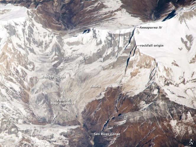
NASA Earth Observatory site describes the affected landscape as: “The landscape in this part of Nepal is shaped by a cycle of landslides and subsequent erosion. As the tectonic collision of India with Asia pushes the Himalaya upward, ice, water, and gravity, assisted by sporadic earthquakes, combine to grind the mountains down. The channel of the SetiRiver itself is cut into the remnants of a much larger debris flow, perhaps 1,000 times as big. 60 to 100 meters (200–330 feet) thick, the landslide deposits are composed of the same limestone as the peaks to the north. Likewise, the May 2012 flow left behind jagged fragments of limestone, carried from the crest of the Himalaya to the foothills in a single event.”
‘Seti’ in local languages means white, and Seti is the ‘White River’, its water is glacial white, turbid and laden with sediment.
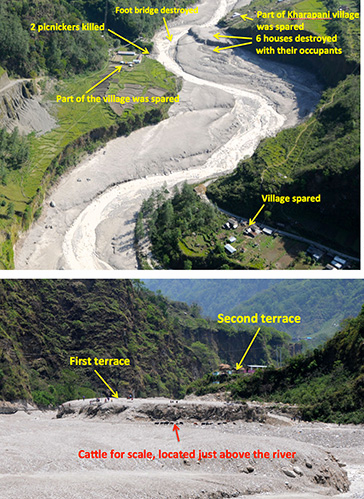
The high intensity floods in May 2012 came in waves, and the first wave alone had around a quarter of a million cubic meters of water in just a few minutes. There were about 27 waves in all over the next hours, according to eyewitnesses, so several million cubic meters of water flowed overall. As Dwivedi et al note, “The huge mass of debris along with ice chunks rushed down the river as a debris flow for 20 kilometres downstream at Kharapani in just 28 minutes (almost 12 meters/second). The flood arrived at Kharapani, where most of casualties occurred, at 9:38 AM and reached the dam of the Seti irrigation system at 10:35 AM… The high-water level at the dam weir at Pokhara was 2.15 meters. The discharge estimation based on the water mark revealed the peak as 935 m3/s (B. Poudel, personal communication). The eye-witnesses in Kharapani area reported huge ice blocks floating in the flood. They felt vibrating ground and heard very loud sound similar to flying of several helicopter together. The smell of the flood water was muddy… Kharapani was a popular spot for picnic and natural hot spring bath… Most of the causalities occurred in this area as the warning message from the Pokhara Airport tower could not reach this area”.
It is heart warming to see that many lives were saved, as Dwivedi et all write, “Capt. Alexander Maximov, the pilot of ultra-light plane of Avia Club Nepal in the morning of May 5 was in a regular sightseeing flight close to the Mountain Machhapuchhre. He noticed a huge dark cloud in the high-mountain depression (Fig. 9) and immediately turned back. He sent a message to the tower of Pokhara Airport. His quick understanding of the unusual event and timely response has saved hundreds of lives during the Seti flood of 5th May 2012. He informed the tower at 9:16 AM and the message was broadcasted through FM radio; police forces evacuated hundreds of people living and working in the bank of the Seti River. Some eye- witnesses in the field said that information about the flood was also received in Kharapani bazar by mobile calls from the people who saw the flooding in the upstream area. This message has helped many people to run to safety. However there was no organized approach of the warning dissemination in the ground.”
Video shot by Capt. Maximov from his aircraft, as the event was was happening:
NASA Earth Observatory image (acquired Dec 22 2013)
However, the series of event started weeks before the flood with a series of rockfalls that sent debris tumbling into the SetiRiver, backing water up in the extremely deep and narrow gorge. The last of these landslides occurred just a week or so before the flood. The situation grew dire on May 5, 2012, when an unusually powerful ice avalanche and rockfall tumbled down a vertical cliff on a ridge just south of Annapurna IV Mountain peak. The total drop from the Annapurna IV ridgeline to the bed of the Seti below Pokhara is about 6,100 meters (20,000 feet) spread over a distance of only 40 kilometers. The distance between the landslide dam and sight of worst floods was about 29 km.
Prof Jeffrey Kargel, writes (http://earthobservatory.nasa.gov/blogs/fromthefield/2014/01/24/setiriverclues/), “A flash flood—what geologists call a hyper concentrated slurry because it was thick with suspended silt—had torn through some villages along the Seti River, in north-central Nepal, just north of the country’s second largest city, Pokhara. It was immediately recognized as a very deadly event, but the death toll—and a tally of those who remain missing but were clearly also killed—was not known exactly for several months. 72 souls lost. Though not large on the scale of global disasters, this event was terrifying for the fact that it seemed to come from nowhere—literally from beneath a blue sky.”
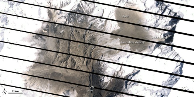
AFTER IMAGE: shows the area on May 6, 2012, roughly 25 hours after the landslide
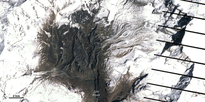
BEFORE IMAGE: the same area on April 20. The diagonal lines are gaps in the data, due to a partial failure of the satellite.
One scenario (see: http://earthobservatory.nasa.gov/IOTD/view.php?id=78070&eocn=image&eoci=related_image) estimates that roughly 22 million cubic meters of rock broke off the slope of Annapurna IV. Colin Stark at Lamont-Doherty Earth Observatory at ColumbiaUniversity said: “There’s a drop of about 2,000 meters into the canyon, so we’re talking an enormous gain in momentum. Then I think the debris ran down the canyon at speeds upwards of 30 meters per second—a guess but what we see for the landslide itself.” Stark estimated that events unfolded in a matter of minutes with no time for a temporary dam to form.
This flood appeared to behave like a glacier lake outburst flood, and the news media can be pardoned for having assumed that it was. Prof Kargel adds: “Seeing that the disaster occurred at the foot of the AnnapurnaRange, within the Greater Himalaya, probably every expert’s first thought was “glacial lake outburst flood” (GLOF), because these were common in Nepal’s Himalaya, and the news accounts of the disaster event resembled accounts of GLOFs”. However, available satellite images showed there were no such lakes. “It was, however, clearly a disaster that had its source in a high Himalayan amphitheatre-like bowl, a glacially-carved structure called the Sabche Cirque. This structure was rimmed by some of Nepal’s most famous, picturesque mountain peaks, including the storied, holy Machapuchare ( “fishtail” peak) & Annapurna IV, a 24,688 ft” mountain.
Annotated photo from Dr. Kargel
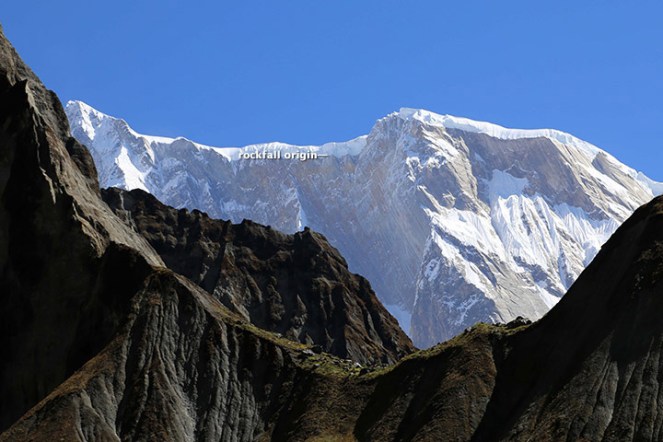
Thanks to video from winged camera of a 2 seater plane incidentally flying over the area at the time of the event, the disaster’s trigger was sourced on a ridgeline near Annapurna IV. Apparently part of this ridge—probably initially the glacier ice— collapsed, dropping ice and rock over 3000 m almost vertically onto unconsolidated rock debris (glacial moraines and ancient glacial lake silts and gravels) resting unstably in the deep bowl of the Sabche Cirque. Some of that loose debris was also swept up by the avalanche, and the mass flowed and dropped through an additional 1,500 m into the SetiRiver gorge. Indeed, the conversion of gravitational potential energy to heat could have melted roughly a tenth of the falling snow and ice by the time it reached the SetiRiver.

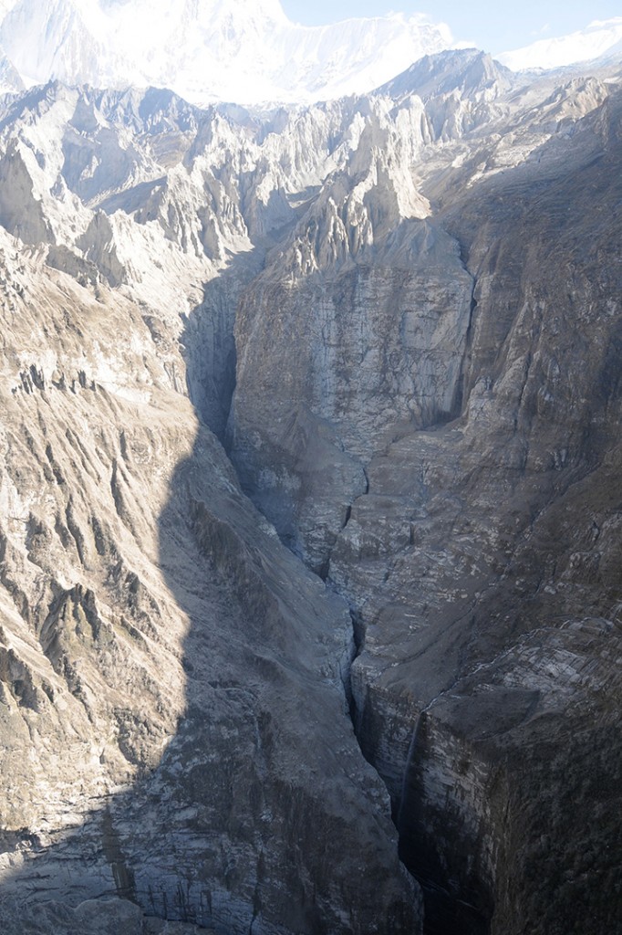
A view of the gorges and also the distant peaks of the Sabche Cirque and the ancient glacial deposits in between. The avalanche entered the gorge from the upper right corner of the scene. (Photo: Dr. Kargel)
One source seemed to be definitely involved, and that was a rockslide-dammed reservoir in the gorge. This was definitely not a GLOF, but was caused by a rockslide into the SetiRiver gorge, formation of an impoundment reservoir over a several week period due to damming of spring snow and ice melt, and then the final triggering event of the mighty rock and ice avalanche off Annapurna IV.
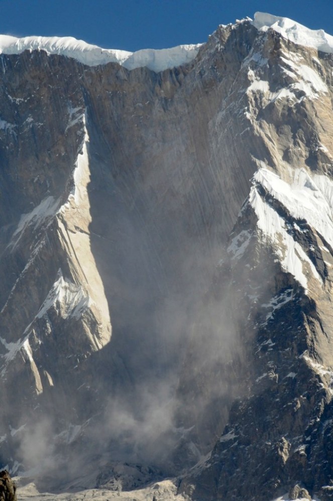
The source area for the avalanche of May 5, 2012. Annapurna IV is just off image to the upper left. (Photo: Dr. Kargel)
Warning: More such events could occur As Dwivedi et al have noted, “The southern slopes of Annapurna range have been experiencing avalanche-triggered high intensity floods also in the past. On August 15, 2003, the Madi River had experienced an unprecedented flash flood which destroyed the recently built rural road and triggered many landslides along its course and killed 5 people”.
“There are good reasons to be concerned,” Jeffrey says, “Something like this will happen again. It’s inevitable.” The Seti River Gorge is unusually prone to dangerous blockages because of how narrow and deep it is. And the same processes that triggered the spring 2012 rockfalls and avalanche are still at work. “The only question is whether future events will be as destructive or whether people in the SetiRiverValley will have absorbed the lessons of 2012 and found ways to move their homes out of the flood plain.” India should not forget that we are downstream country in Seti basin and what happens there will flow down here too.
In an earlier excellent paper on this event, Jorg Hanisch et al recommends that this event requires deep investigations and “Marsyangdi Khola, Madi Khola, Modi Khola and Kali Gandaki, all with apparent origin in the high-mountain environment of Annapurna Range (Hormann 1974; Yamanaka and Iwata 1982) should be included in the investigations… A new catastrophe of similar size would have an apocalyptic impact: about half a million people live in the valley today. A detailed investigation of the circumstances of the disaster on May 5th, especially the possible influence of global warming on the trigger of the disaster, and a reliable forecast of a potential recurrence of similar events or of even much greater scope, are urgently required. For this, the thorough understanding of the conditions, triggers and mechanisms of the huge flows in the past to compare it with the recent flood is indispensable as well.”
The proposal for a 140 MW Tanahu Seti storage project downstream of this flood event & supported by the Asian Development Bank, Japan International Cooperation Agency, European Investment Bank and Abu Dhabi Fund is questionable, says Ratan Bhandari of Nepal. Considering that the Seti River Basin is prone to such events in future, the proposal seems disastrous.
More significantly, this whole episode raises the question as to how much do we really know about the Himalayas. Uttarakhand disaster of June 2013 was a wake up call to understand the Himalayan ecosystem and its implications for future well being of the people and environment of India. However, in stead of learning any lessons, our governments in Uttarakhand (as also in Himachal Pradesh, Kashmir and North East) and at the Centre, with environmentally-challenged Mr Veerappa Moily as the environment minister, are playing into the hands of short sighted vested interests. This is also apparent in the recent decision to sanction the massive Lakhwar dam on YamunaRiver in Uttarakhand without so much as an Environmental Impact Assessment!
We still do not have full explanation for the Uttarakhand disaster of June 2013. This explanation of the Seti River Disaster in the same Himalayas, which happened just a year before the Uttarakhand disaster highlights the urgent need for more serious studies and applying precautionary principle while dealing with the Himalayas, its rivers and flood plains.
Compiled by SANDRP
Sources:
1. http://earthobservatory.nasa.gov/NaturalHazards/view.php?id=82937&src=nha dated January 25, 2014
2. http://earthobservatory.nasa.gov/blogs/fromthefield/2014/01/24/setiriverclues/ This entry was posted on Friday, January 24th, 2014 at 10:34 am. See the absolutely amazing photos on the site that gives an insight into the situation in the head reaches of Seti River… possibly indicates how little we know about the catchments of our Himalayan Rivers.
3. http://earthobservatory.nasa.gov/IOTD/view.php?id=78070&eocn=image&eoci=related_image dated May 6, 2012
4. http://earthobservatory.nasa.gov/NaturalHazards/view.php?id=78117&eocn=image&eoci=morenh dated May 23, 2012
5. http://blogs.agu.org/landslideblog/2012/05/23/understanding-the-seti-river-landslide-in-nepal/, dated May 23, 2012
6. http://www.icimod.org/?q=7377, dated June 25, 2012
7. “Cause and mechanism of the Seti River flood, 5th May 2012, western Nepal” by Shreekamal Dwivedi and Yojana Neupane, Department of Water Induced Disaster Prevention, Pulchwok, Lalitpur, Nepal (shreekamal @gmail.com), published in Journal of Nepal Geological Society, 2013, Vol. 46, pp. 11-18
8. Famous movie clip of the area, http://www.youtube.com/watch?v=Uk82ggshSKs&feature=related you can see landslide in the clip at 56-57 seconds of the movie. At this time the avalanche had not occurred yet. After taking one round the aircraft pilot has noticed the dark grey brown cloud formed by the avalanche (see the movie at 2 minute 7 seconds). This is thanks to Shreekamal Dwivedi
9. “The Pokhara May 5th fl ood disaster: A last warning sign sent by nature?” by Jörg Hanisch, Achyuata Koirala and Netra P. Bhandary, Journal of Nepal Geological Society, 2013, Vol. 46, pp. 1-10

Reason of SETI flood by damming due to avalanches/ slides . This paper also need support from water level recorded before 15 days of flooding. As informed by the people living on the bank that water level -river level were shown sign of falling, which definitely support that there were events before a week or more. JAGAT (bhusaljagat@yahoo.com)
LikeLike
Reblogged this on GEOMATIC'S ENTHUSIAST and commented:
Causes of the Deadly Seti River Flash Flood……..published by Jeffrey Kargel ;hydrologist at the University of Arizona and for the Global Land Ice Measurements from Space project. This was his account of the research he did during the aftermath of a deadly flash flood in Nepal’s Seti River Valley to determine its cause
LikeLike
This reference of the “Cause and mechanism of the Seti River flood, 5th May 2012, western Nepal” is available online in https://www.nepjol.info/index.php/JNGS/article/view/31576 ,
LikeLike