“At the ground level people are really interested and they want to get involved and our report if nothing else, seem to have served the purpose of triggering such kind of an interest” said Dr Madhav Gadgil while delivering a lecture on “Democracy and ecology in contemporary India” in Delhi in July 2013. He was referring to the 2010-11 report of the Western Ghats Ecology Expert Panel (WGEEP), which he chaired and which was one of the major contributions of Dr Gadgil to India’s environmental governance. One of us accompanied him during some of his travels which mainly consisted of back to back and often heated meetings in some of the remotest corners of the Western Ghats. The meetings were not only about plants, trees and rivers, but about what the villagers feel about development and how it should happen. No one had asked such questions before. It was democratisation of Environmental Governance at its messiest and the most beautiful. Something that was rarely attempted before. Or since.
Continue reading “MADHAV GADGIL’s unflinching faith in Community led Natural Resource Governance”Category: Western Ghats
Dabhil Mauli: Stories and Struggles of a Small River in the Western Ghats
At the window of his new house, in a crowded suburb of Pune sits Aba Gawas. He looks out at the traffic and talks of his river Dabhil, more than 400 kms away from him. For years, Aba has fought hard to protect the river. He calls it Dabhil Mauli, a term of endearment reserved for mothers and deities. He is not keeping very well and longs to return to Dabhil Mauli. I realize with a sudden pang, rivers are home.
Continue reading “Dabhil Mauli: Stories and Struggles of a Small River in the Western Ghats”
Letter to the EAC: No justification for Adani Dams in the Western Ghats
28.11.24
To,
The Chairperson and Members,
Expert Appraisal Committee, River Valley Projects,
Ministry of Environment, Forests and Climate Change
New Delhi
Subject: Submission against 1500 MW Warasgaon Warangi Pumped Storage Project by Adani Green Energy to be discussed in the 19th EAC meeting for TORs
Respected Sirs,
We see that Adani Green Energy’s 1500 MW Warasgaon-Warangi Pumped Storage Project is being considered for fresh TORs in the upcoming meeting of the EAC. We have gone through the documents uploaded by the proponent (AGEL) on MoEF CC’s Parivesh Website.[1]
Continue reading “Letter to the EAC: No justification for Adani Dams in the Western Ghats”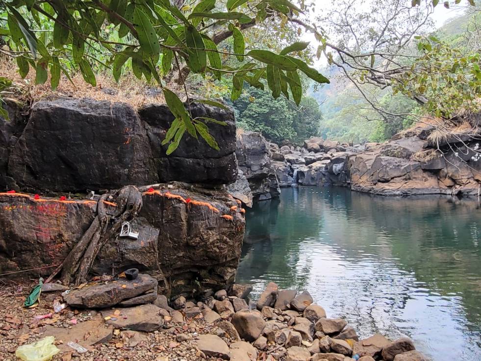 MoEF Committee Rejects the Adani Application and asks to apply afresh for Warasgaon-Warangi Project!
MoEF Committee Rejects the Adani Application and asks to apply afresh for Warasgaon-Warangi Project!
In a respite to forest dwelling communities, fragile biodiversity and community conservation areas in the Western Ghats, Expert Appraisal Committee (EAC) of the Union MoEF (Ministry of Environment and Forests) rejected Adani Energy’s application for 1500 MW Warasgaon-Warangi Pump Storage Project. The committee has asked the proponent to apply afresh for Stage I Clearance, adding several conditions to assessment.
Continue reading “MoEF Committee Rejects the Adani Application and asks to apply afresh for Warasgaon-Warangi Project!”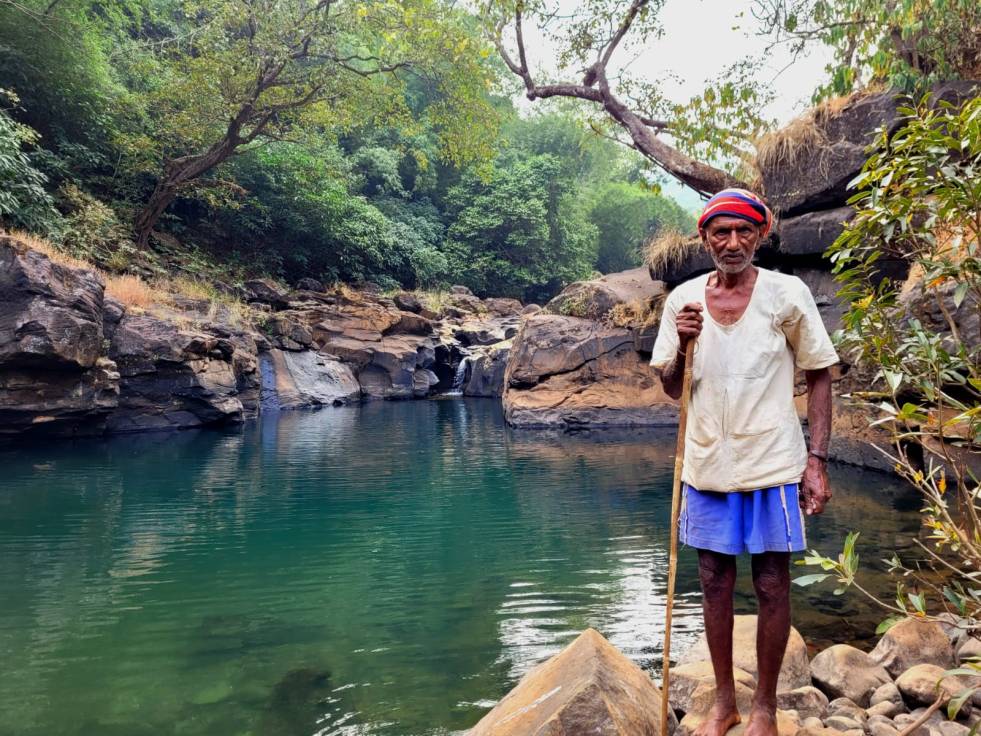
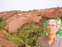
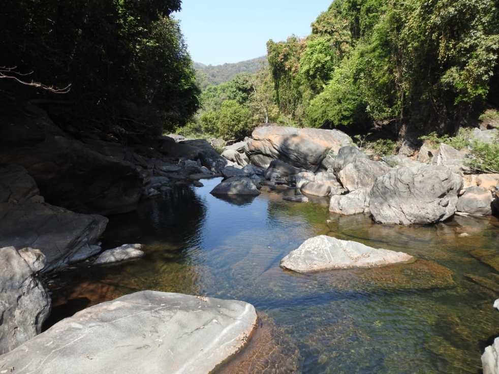
Adani Pump Storage Dams: Defiling sacred pools and fish sanctuaries in the Western Ghats
Adani Energy proposes to build two large dams in the heart of Western Ghats as a part of Warangi-Warasgaon Pumped Storage Project. One of the dams will be located in Tekpowale Village, about 65 kms from Pune.
I actually could not believe my eyes when I read the name Tekpowale.
Continue reading “Adani Pump Storage Dams: Defiling sacred pools and fish sanctuaries in the Western Ghats”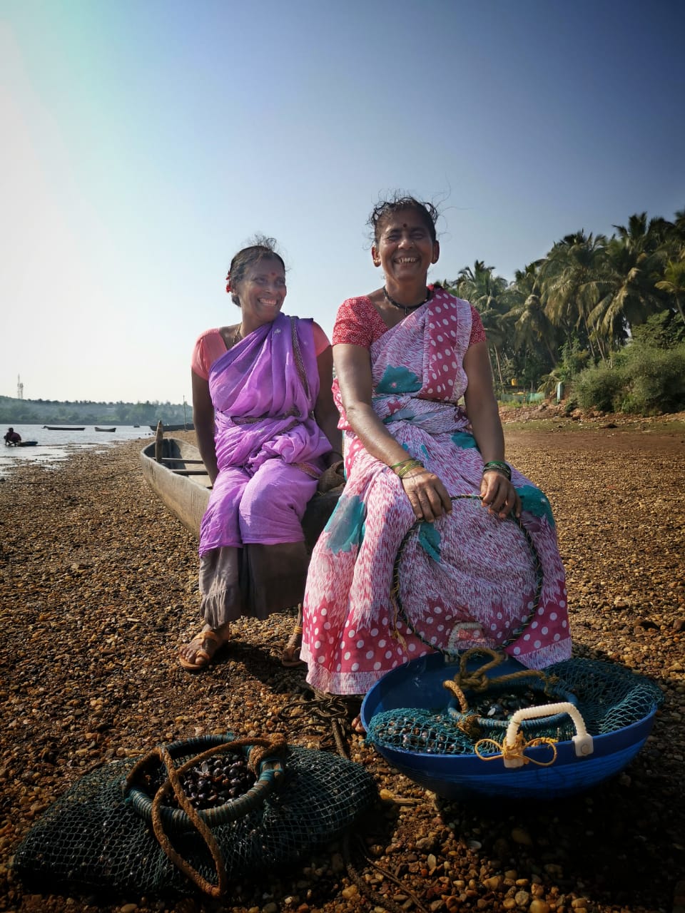
People of the free-flowing Aghanashini
“I don’t know my age. But I know that I have been coming to this river since I was a child everyday to collect bivalves.” Janaki Amma told us while wading waist-deep in the Aghanashini estuary. Janaki Amma is at least 70 years old and has the agility of a ballet dancer as she plunges inside the limpid water one more time, and comes up with a new haul of bivalves in a wicker basket tied to her waist.
On the banks of the river, Thulasi and Sumitra sit laughing on an old wooden boat, as only old friends can. They collect bivalves too. They have never seen the river not having the shiny, black bivalves. Throughout Aghanashini Estuary, we hear this again and again: fisherfolk and rice farmers, priests and devotees, older women and solid middle-aged men: all echoing the sentiment: “Our lives are entwined with the river.” Continue reading “People of the free-flowing Aghanashini”
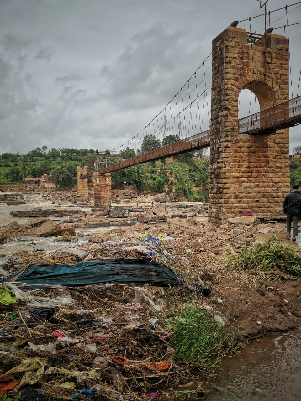
Breaching Historic Flood Levels many times over: Aftermath of Ghataprabha Floods 2019
Photo-blog 2
On the 8th August 2019, Krishna River itself and several of its tributaries in Maharashtra as well as Karnataka crossed their Highest Flood Levels at multiple places to set new records. Nowhere is it more stark than in Gokak Falls on the River Ghataprabha in Belgaum District of Karnataka. At Gokak Falls, the Highest Flood Level of the river was more than 553 meters and exceeded the earlier record by more than 5 meters! (For More Details: https://sandrp.in/2019/08/12/krishna-basin-floods-in-karnataka-the-role-of-dams/)
Abhay Kanvinde visited Gokak Falls, Hidkal Dam and villages along the Ghataprabha and Hiranyakeshi Rivers in Karnataka to understand and photo-document the impact of raging water levels on communities and ecosystems. Some interesting facts were thrown up in this trip. Mainly that 2019 Flood levels exceeded not only the 2005 and 2006 levels, but even the historic 1914 Flood levels, which are carefully marked by the British at Gokak Hydropower Station. Continue reading “Breaching Historic Flood Levels many times over: Aftermath of Ghataprabha Floods 2019”
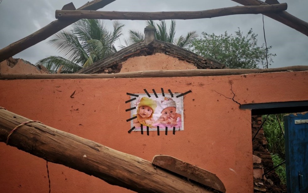
Homes in Deluge: Aftermath of Maharashtra Floods 2019
Photo-blog 1
August 2019 Floods in Sangli and Kolhapur districts of Maharashtra have been historic. River levels washed away all past records many times over. New High Flood Levels (HFL) were reached multiple times at multiple places both in Sangli and Kolhapur. These districts, which form the fertile Black Cotton Soil belt of Maharashtra, are the floodplains of mighty rivers of the Krishna Basin: Krishna, Koyna, Warna, Panchaganga, Tarli, Urmodi, Dudhganga, Hiranyakeshi etc.
On the 8th August, Krishna breached its HFL: Highest Flood Level at two places in Maharashtra (Kurundwad and Arjunwad). On the same day, Warna and Panchaganga too crossed their HFLs at two places: Samdoli and Terwad (Kolhapur). Continue reading “Homes in Deluge: Aftermath of Maharashtra Floods 2019”

Remembering Latha
It took some time to write. Latha chechi and me talked just 4 days before she passed away on Nov 16, 2017. As usual, it was about when we will meet next and go to Athirappilly Falls and travel to the river together. Her voice was light, it had a surreal gentleness. We agreed on everything, which was rare. After just a few minutes, Unni gently took the phone from her and told me she needed to sleep. It just didn’t feel right.
We first met virtually about 10 years back, discussing rivers and forests and then, through her initiative, came together to organize the first civil society workshop on Environmental Flows in January 2009 with SANDRP. Since then, Latha Chechi has been a bubbling, enthusiastic and wise constant. We worked on several submissions together, discussed strategies and ideas, eating each other’s heads about what worked and what can work and always, I was always taken aback by her unmatched way of linking issues.
She told me, “You need one particular river. Work on all the rivers of world, but have that one river to go back to.” Continue reading “Remembering Latha”

The state of the Aghanashini River Estuary
-Guest Blog by Vidyadhar Atkore
Aghanashini –is a small village situated on the southern bank of Aghanashini River in the Kumta taluka of Uttar Kannada district in Karnataka state. River Aghanashini draws its name from this village, it is also known as Tadri river as Tadri village is situated on the river mouth on the north bank. Vast estuary and open sea at the village makes you humble. A drive along the bank of estuary is pleasant experience in the hot summer. On one side, big coconut trees and on other side, isolated, stunted mangrove patches draw your attention. Continue reading “The state of the Aghanashini River Estuary”
