Last week, a note was in circulation, which listed few border related conflicts between India (Bihar) and Nepal (Parsa). Of the nine points mentioned in the note, seven were directly or indirectly related to either a river, or access to water, or flood protection works. Out of the seven, one issue was with regard to an old concern involving River Pandai, which has witnessed different dimension of cooperation and discord between communities across the Indo-Nepal border in Pashchim (West) Champaran and Parsa districts respectively. However, the note highlight the conflict as a recent one with a specific intent and that was explained as ‘नेपालकीकरतूत : पानीरोकलिया, ताकिएसएसबीकेजवानपरेशानहों‘(Nepal’s handiwork : They stopped the water to trouble the Sashastra Seema Bal (SSB) jawans). After having read the note, I decided to write this piece based on my own understanding and learnings (through direct interactions and personal communication in the past and references) about River Pandai and Bhikhna Thori, to provide a comprehensive perspective.
“Bolo Jai Jai Baba Bhole”, the Prime Minister Narendrabhai Modi, while speaking at Kedarnath in Uttarakhand in Oct 2017[i], asked the people in audience to chant with him. Indian deity Mahadev, the presiding deity at Kedarnath on the banks of Mandakini river is possibly the closest to rivers and nature among all the deities, as is also clear from his attire. Baba Bhole is one of the many names of this deity. Incidentally, the massive, controversial Pancheshwar Dam a pet project of Mr Modi will also submerge the Pancheshwar Mahadev Temple, where too, the presiding deity is same Bhole Baba. But we will come back to Bhole Baba. Continue reading “Who exactly needs the Pancheshwar Dam?”→
(Above: Protest outside MoEF on Oct 24, 2017 when EAC met to consider EC for Pancheshwar Project)
Oct 23, 2017
To
Chairman and Members, Expert Appraisal Committee (River Valley Projects), Union Ministry of Environment and Forests, Jor Bagh, New Delhi
Respected Chairman and Members,
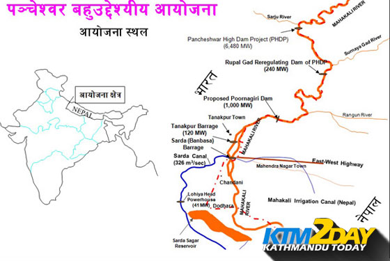
The agenda of the EAC (for RVP) to be held on Oct 24, 2017, put up on the EC website only on Oct 18, 2017, just six days before the EAC meeting includes the 5040 MW Pancheshwar Multipurpose project (PMP), India’s largest proposed hydropower projects. The agenda should be available at least ten days before the meeting, and this should also be a reason for not considering the Pancheshwar project by EAC for its meeting on Oct 24. Moreover agenda mentions 5600 MW Pancheshwar project, where as the capacity as per EIA is 5040 MW. Is MoEF just callous in mentioning wrong installed capacity or has the capacity gone up? In either case, the 5040 MW Pancheshwar project should not be on EAC agenda. Continue reading “Letter to MoEF’s Expert Committee: Why Pancheshwar Project should not be considered for Environment Clearance”→
COPY to: 1. IA Division (River Valley Projects) MoEF, Delhi
2. Chairman and Members of Expert Appraisal Committee on River Valley Projects
Respected Members of Public Hearing Panel for Pancheshwar Dam,
The public hearing now being conducted for the massive Pancheshwar Dam at Pithoragarh today, as part of the requirement under the EIA notification of Sept 2006 is being held in complete violation of letter and spirit of many norms of the EIA notification. Hence these public hearings should be cancelled. They should be rescheduled after appropriate conditions are achieved for the public hearing. Some of the key reasons for this are listed below, but these are not exhaustive reasons, but only a list of key indicative reasons. Continue reading “Cancel Pancheshwar Dam Public Hearings: It involves too many violations and illegalities”→
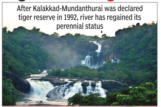
Tamirabarani teaches: Saving tiger is saving riverAfter Kalakkad-Mundanthurai was declared tiger reserve in 1992, Tamirabarani river has regained its perennial status. Though shorter than Cauvery and Vaigai, Tamirabarani has always held a special place in the state. It started turning dry for four months every year. People of Tirunelveli and Tuticorin thought their river too was going the way of other state rivers. But a move to save the tiger inadvertently became a save the-river policy. The Union ministry of environment and forests declared the Kalakkad – Mundanthurai area as a tiger reserve in 1992. In three years, there was a noticeable change. A study on water inflow into the Karayar river, a tributary, inside the reserve was taken up. Records show that from 1946 till 1990, the river received only 13,000 cubic feet of water annually. After the area was declared as a tiger reserve, the inflow increased to 23,000 cubic feet.
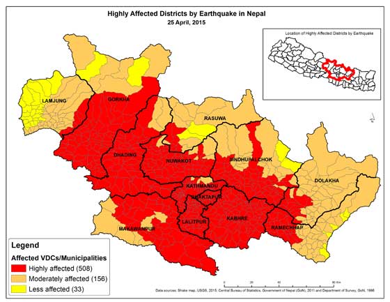
The massive Nepal earthquake of 7.9 intensity (Richter scale) on April 25, 2015 with epicenter 77 km north-west of Kathmandu in Nepal is a major noteworthy event in the Himalayas which also has warnings for what is in store for future. The earthquake left a major trail of destruction affecting over 20 districts of Nepal, of which 8 million live in 11 severely affected districts. Besides, it affected areas of India (Bihar, UP, W Bengal, Sikkim, Assam), Bangladesh, Tibet. The earthquake has now been given the official name of Gorkha Earthquake.
Attempt to blast the dam starts; 8 killed, many more at missing, at risk;
Google map of the location, the landslide location seems just upstream of the dam
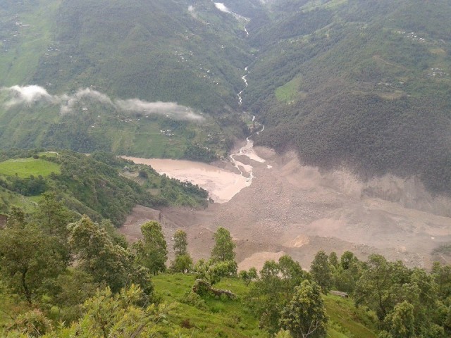
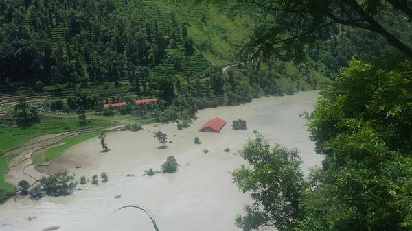
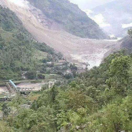
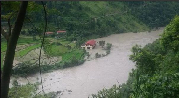
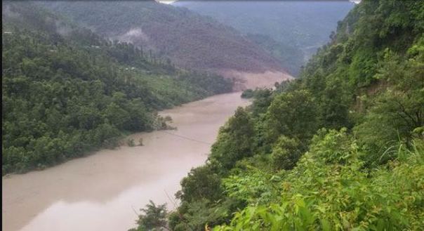
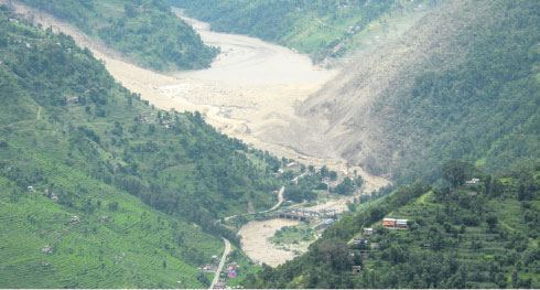
A massive landslide at around 2.30 am on Aug 2, 2014 has blocked the flow of the river Sunkoshi in Nepal. Twelve hours later and after first failed attempt by the Nepali army to blast the artificial dam, the reservoir behind the dam continues to swell. Already eight people have been confirmed dead, over 300 are reported missing[1]. Many more are at risk in the downstream Nepal and further downstream India. Sunami Power house has already been inundated. The Landslide seems close to an existing dam on the river. If this is true, when the landslide dam bursts either due to the army efforts or due to the water pressure, it is likely to take the dam with it and this could increase the downstream impacts.
A view of the landslide dam photo courtesy Setopati.com
Prof David Petley wrote to SANDRP about this: “It is very dangerous indeed. I know this site very well as we have been working in that valley for a decade or so. I suspect that the breach will happen quite quickly and will be very damaging.”
“Bishyari much more devastating than GLOFs” Former Water Resources Minister and well known water expert Dipak Gyawali told SANDRP: “Bishyari is the Nepali word for this kind of a “landslide dammed lake outburst flood” much more devastating than the GLOFs . This is a geo-hydrological phenomenon and as the pictures show, brings down entire mountains with thick forests on them. This one was on an old landslide still active but exacerbated by the recent spate of hydropower as well as road blasting.” Jayanta Bandyopadhyay and Dipak Gyawali were the first to put the word ‘bishyari’ in English, in a 1994 much-quoted article in Mountain Research and Development.
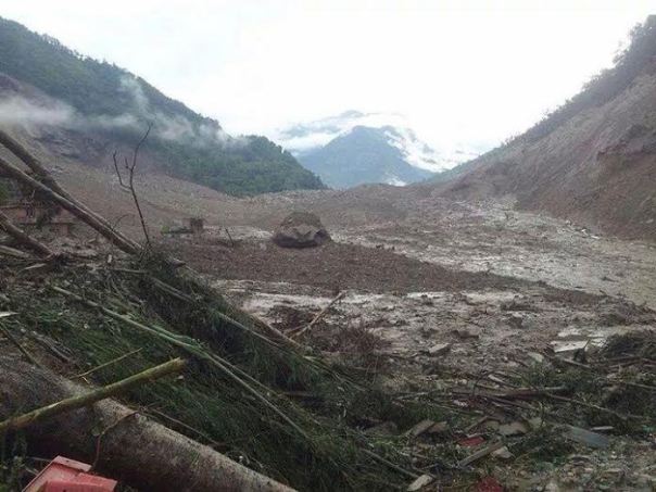
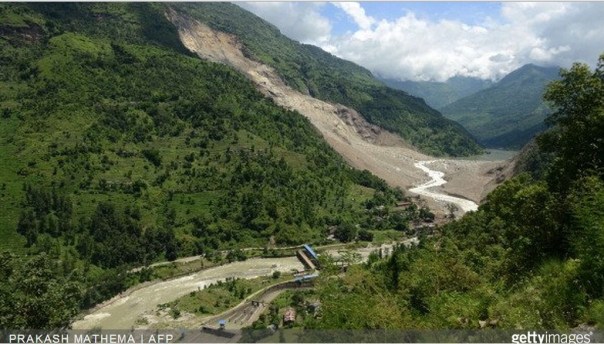
Massive scale of the landslide dam, photo thanks to Kathmandu Post
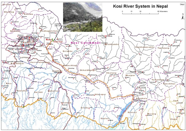
Indian border is about 260 kilometers downstream from the landslide when measured along the river and on the way there is also the Kosi Barrage at Bhaimanagar / Rajbiraj (correction from earlier reported distance).
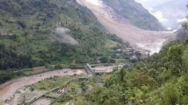
A view of the massive landslide dam, photo courtesy Nepalhub.com
This morning, an email from our friend Ratan Bhandari from Kathmandu informed of this development, and it seems like a bad news to precede Indian Prime Minister Narendra Modi’s visit to Nepal, but it could also be a timely wake up call not to go for massive interventions in the Himalayan states.
Rising reservoir behind landslide on Sunkoshi river, Nepalhub.com
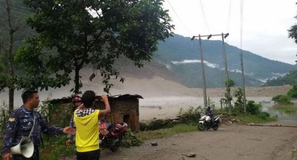
The massive landslide blocked Sunkoshi River at Mankha VDC in Sindhupalchowk[2] district. Around two dozens houses were buried in the landslide. The landslide has also buried Arniko Highway at Dam Site in Mankha VDC. Locals in Barhabishe, Lamesanghu, Khadichaur, Dolalghat, among other surrounding areas have moved to safety fearing that the blocked river may burst anytime. A Nepal Army chopper has been deployed to intensify the rescue work. The government has mobilized security forces to break a landslide dam that has blocked the flow of water in Sunkoshi River[3] in Jure of Mankha VDC, Sindhupalchowk.
A view of the dam and the river, photo courtesy Setopati.com
The Central Natural Disaster Relief Committee (CNDRC) has asked the Ministry of Home Affairs[4] to declare the areas downstream the blocked Sunkoshi River, from Jure of Sindhupalchok to Nepal-India border, “crisis-hit region” as the threat of outburst floods loomed large. It is hoped that the Indian authorities in downstream Indian areas are alert and doing necessary steps for the protection of life and property in India.
Landslide and the dam photo courtesy onlinekhabar.com
According to the Ministry of Home Affairs, the water level rose to above 130 metres. About 100 houses on the bank of the river have been submerged in Jure of Ramche VDC-5[5], the Araniko highway itself has been blocked.
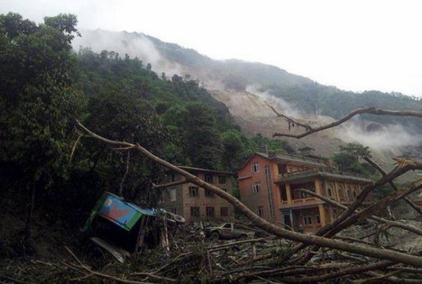
Houses affected by landslide, photo courtesy onlinekhabar.com
The Sunima hydropower project (constructed in 2004-5) that has already been inundated is a 2.6 MW project built by Himal Hydro[6]. The dam of the 10.5 MW Sunkoshi hydro project (completed in 1972 with Chinese aid) is immediately downstream from the landslide, and is likely to face damage along with its power station further downstream whenever the dam breaches.
A view of Sanima Power House in Sindhupalchok, photo courtsy Himalayan Times, Nepal
Dr David Petley, who has traveled in the area writes in his blog[7]: “However, it is now a crisis. In the peak of monsoon season the river flow is high, and the images show that the lake is filling quickly. The images suggest that there is no reason to be confident that the dam will not breach rapidly when overtopped – indeed, quite the opposite I think as the length of the dam is not large and the materials appear to be fine grained. A breach now could generate a very large flood; when full the effects could be very serious… So what to do? Well of course the first measure is to evacuate people downstream, and this has started. The second is to put a warning system in place, probably at this stage consisting of an observation team with appropriate communications. The third will be to start to excavate a channel, which will require heavy machinery… This is a very difficult problem to manage, so Nepal should seek international help. The best qualified people are the teams that dealt with the valley blocking landslide crisis after the Wenchuan earthquake in China. Given the strategic importance of this road, the Chinese may want to help. However, time is very limited.”
About the possible causes of the massive landslide, this article says it is partly due to the after effects of last year’s landslide at the same site: http://www.myrepublica.com/portal/index.php?action=news_details&news_id=80211.
It also says that the district has seen such landslide blocked rivers causing disasters in the past too including the ones in 1982 (in Balephi village of the district when 97 people had lost their lives) and 1996 (54 people had died due to a landslide caused by dam outburst flood in Larcha, another village of the district).
A view of the blocked Sunkoshi River in Sindhupalchok, Photo courtesy Himalayan Times Nepal
We hope all such necessary steps are urgently taken and Indian government, Bihar state government and Nepal government coordinates in this on urgent basis.
A man taking a photo of the artificial lake formed due to Sunkoshi River Blockade in Sindhupalchok
Himanshu Thakkar, SANDRP
PS: According to http://hydrology.gov.np/new/bull3/index.php/hydrology/station/graph_view?stationId=104&deviceId=91&categoryId=6, the inflow is about 150 cubic meters per second, so in 11 hrs the volume stored would be about 6 million cubic meters. The impact on the downstream would depend on the way this water gets released. (This link thanks to comment on Dave Petley blog.) The lake overflow could have just started at around 1.30 Indian Std Time, but it is not clear what is the outflow rate.
PS 2: Comments from Dr Dinesh Kumar Mishra:
A. Flood warning has already being issued by the district administration in Saharsa about 3 hours ago that there is an imminent danger of floods along the embankment and the most vulnerable point is the site of 1984 breach.
Map with orange line showing the path that the flood pulse from the landslide dam will take to reach Kosi in India, FMIS map
B. There is some activity at the Bhimnagar barrage with officials and engineers keeping an eye over the situation. I am told that the Government has asked its officers of the Kosi Project at Birpur to move to safer places. Otherwise, there is calm at Birpur.
C. I have just received a message from a friend of mine from village Bela in Marauna block of Supaul district (this village is located within the Kosi embankments) and they have not received any warning from the Government and only know that something odd has happened in Nepal.
D. Villages near Madhepur block along the western embankment of the Kosi have not received any warning. They are not aware if anything wrong has happened in Nepal.
E. खबर है की सुन कोसी नदी की धारा पहाड़ धंसने की वजह से बाधित हो गयी है। इस की वजह से नदी के सामने बाँध बन गया है और ये किसी भी समय टूट सकता है जिस से निचले इलाकों को खतरा हो सकता है। मेरी अभी सहरसा शहर, सिमरी बख्तियारपुर के कठघरा गावों, ग्राम बेला (मारौना प्रखंड), जिला सुपौल; बीरपुर (कोसी बराज के निकट), कमलपुर (प्रखंड निर्मली) – जिला सुपौल और मधेपुर के अपने मित्रों से बात हुई है। सहरसा से खबर है कि वहां प्रशासन ने संभावित बाढ़ की चेतावनी दी है मगर सुपौल में अभी तक ऐसा नहीं हुआ है। बेला, कठघरा, भेजा में लोगों को इतनी जानकारी तो है की नेपाल में कुछ गड़बड़ हुआ है और नदी मे ज़्यादा पानी छोड़े जाने की आशंका है पर उस से ज़्यादा जानकारी नहीं है। सहरसा में कोसी तटबंध के किनारे बसे लोगों को संभावित बाढ़ के प्रति आगाह किया गया है।
F. (1700 hrs) ये जगह त्रिबेनी के ऊपर सुन कोसी नदी पर है. त्रिबेनी भारत – नेपाल सीमा से करीब ६० की। मी। पर है और जहां भू स्खलन हुआ है वो करीब ७० की. मी. दूर होगा। अगर ये मिट्टी का बाँध टूट जाता है या तोड़ दिया जाता है जैसा की नेपाली सेना कोशिश कर रही है, ऐसा बताते हैं, तो पानी को भारतीय सीमा तक आने मे समय लगेगा और तय्यारी के लिये कुछ समय मिल जायेगा।मेरी अभी बिहार राज्य आपदा प्रबंधन प्राधिकार से बात हुई है और उन्होने बताया की राज्य का आपदा प्रबंधन विभाग सक्रिय है और एन। डी। आर। एफ। के जवान सीमा पर पहुंच रहे हैं। बेला (मारौना प्रखंड , जी सुपौल) वालों ने स्थानीय प्रशासन से बात की थी। उनका कहना है कि आप लोगों का गाओं ऊँची जगह पर बसा हुआ है इसलिये चिंता की कोई बात नहीं है।
PS 3: Just (1600 hrs) called Control Room of NDMA (ph no: 011 26701728) and Mr Kulwinder informed me that Nepal govt informed NDMA at 1136 hrs about this and NDMA in turn has alerted Bihar Govt, Home Ministry, Cabinet Secretariat and others, he said PMO would also be aware of this when I told him PM is going to Nepal tomorrow. They have kept 9th NDRF battalion at Patna/ Kolkata on alert. He was aware that Koshi would be affected. He is not aware of any cooperation from Indian side on this.
PS 4: 1730 hrs: According to reliable sources, there is debate between Nepalese authorities saying that all the gates of the Koshi barrage should be kept open for the flood wave to safely pass and elements on Indian side that, that should wait for the flood wave to come. A contingent of senior officials are being airdropped to the barrage site with letter from CM. The second blast at the landslide dam in the meantime managed to lower the upstream reservoir water level by 2 m, but it is not clear if the outflow is continuing or has stopped.
1820 hrs: All 56 gates of Kosi Barrage have been opened, good to see that better sense have prevailed.
PS 5: Update from http://www.myrepublica.com/portal/index.php?action=news_details&news_id=80146
(Nepali time 4:00 pm) “The Sunkoshi River has started to flow after Nepal Army (NA) detonated two explosives. The water volume in the river downstream has increased as compared to the regular one. Authorities believe resumption of river flow will put off possible damages.” The landslide dam has created reservoir of 90-100 m height.
From: http://www.myrepublica.com/portal/index.php?action=news_details&news_id=80184
“Three eastern districts, Sunsari, Saptari and Udayapur have maintained high alert to remain safe from the possible Saptakoshi River inundation. The local administration has already begun its task to alert the people of riverside in Sunsari to shift them to safer places while the administration in Udaypur and Saptari districts have made arrangements to inform people about the blockage of river and aware people about the possible flooding, said Sharma. It is possible that as many as 500 VDCs in the districts and Bihar State of India would be inundated if the blocked landslide debris opened at once and the Koshi barrage was damaged.”
“Some 14 VDCs in Khotang district are at high risk of inundation after the landslide in Sindhupalchok district blocked the passage of Bhote Koshi River. Bahunidanda, Dikuwa, Chyasmitar, Durchhim, Dhitung, Rajapani, Batase, Chichkiramche, Barahapokhari, Saunechaur, Suntale and other VDC that are on the side of Sunkoshi river are at high risk of flooding. The District Administration Office and District Police Office have urged the locals to shift in the safe areas to remain away from the possible risks. Assistant Chief District Officer Arjun Rai said that the locals of the low land site have been asked to move to higher ground. ”
“‘Sri Lanka tapu’, which lies in middle of Sapta Koshi River, has been declared flood crisis zone in view of possible flash flood caused by likely bursting of artificial lake formed by landslide in Sunkoshi River. Local administration declared the area flood crisis zone which has settlements of over 12,000 persons on Saturday. Security personnel along with government and non-government organizations have been deployed to aware and shift locals to safer places in east and west of the island which is home to indigenous nationalities of Tarai and Hilly regions. Chief District Officer Sudarshan Prasad Dhakal said that security agencies have been directed to shift children and elders along with valuables to a safer place. Local administration has also urged people in seven other VDCs— Barahachhetra, Mahendra Nagar, Prakashpur, Madhuban, Paschim Kusahawa, Shreepur and Haripur— to move to a safer place. The possible flash flood will reach Sapta Koshi barrage in around 10 hours, and all 56 floodgates have been opened in view of possible danger, informed CDO Dhakal. ”
“…two iron gates, which diverted water to intake of Sunkoshi Hydropower Project (10 megawatts), was swept away by flood in the wee hours on Saturday morning… Similarly, power supply from 45 megawatts Upper Bhotekoshi Hydropower Project has also been disrupted… Likewise, 11 kV transmission line for evacuating power from Chaku Khola (total 6 megawatts) and Bhairab Kunda (3 megawatts) and another 33kV transmission line for evacuating power from Sunkoshi Hydropower Project (10 megawatts) has also been damaged… Officials at Load Dispatch Center of NEA also said Sunkoshi River flooding may breach dams and affect power supply from Khimti Hydropower Project and others hydropower projects on the Tamakoshi River basin.”
“The Central Water Commission has estimated a discharge of 14 lakh cusecs of water but the Indian embassy in Kathmandu has informed the National Disaster Management Authority about the likely discharge of 25 lakh cusecs of water post blast. In either case, 40% of the discharge will gush into Bihar.
The water will take about 12 hours to hit the Kosi barrage which has the capacity of sustaining pressure of only eight lakh cusecs. The flood, if it occurs, would affect a population of 1.5 lakh in Bihar’s eight districts, including 50,000 people in 22 panchayats of Supaul district alone.”
It is well known that Kosi embankment breached in Aug 2008 when flow was below 1.5 lakh cusecs, so even if barrage is able to take 8 lakh cusecs (seems unlikely), embankment is likely breached at much lower flows.
“As the dam resulting from the landslide grew larger by the hour, at least three human settlements became submerged. Damsite bazaar in Mankha-1, Kagune village in Mankha-5 and another settlement in Tekanpur-5 vanished into the water. Security personnel rescued 16 people from Damsite and seven from Tekanpur villages before these became submerged; no one was rescued from Kagune village.
According to Sindhupalchok District Police Office, 26 houses at Damsite, 16 at Kagune and seven houses at Tekanpur disappeared. At Damsite, a school was also buried under the landslide-induced dam.
Local authorities say explosions set off by the NA have slightly reduced the risk of flood outburst. “The risk has been reduced,” said Chief District Officer Gopal Prasad Parajuli. “The water volume in the landslide-induced dam is declining. The blocked water is now flowing through the small channels created by the explosions, albeit only partially.””
A view of water flowing out of landslide dam, photo from myrepublica.com
The last para is good news since it seems to suggest (as can also be seen from above photo) that water has slowly started flowing out and hopefully there is no more accumulation, but slow depletion.
PS 10: Some updates from Bihar (different sources):
At 06:00 AM water level was 1.06 lakh cusec at Kosi Barrage. Water level increasing at the rate of 2-3 thousand cusec per hour. Hish water flow may reach around 1-1:30 PMin Bihar on Aug 3. High alert in 9 districts. (1.Supaul, 2. Saharsa, 3.Madhepura, 4. Khagaria, 5. Bhagalpur, 6.Araria, 7.Purnia, 8.Madhubani 9. Katihar). Threat of danger till Monday morning (4th August 2014)
Three controlled blast by Nepal Army. First at 01:50 PM, Second at 02:50 PM and third at 03:30 PM for water flowing, it is not clear how much water is flowing out.
This is good to know: “‘Outflow of water normal“: Meanwhile, the Sunkoshi River is flowing out of the lake in a controlled rate today, according to the National Emergency Operation Centre (NEOC) of the Ministry of Home Affairs. Water level has not decreased significantly as the volume rate of water flowing in and out of the lake are comparable.”
The same report claims: “According to an official at the NEOC, about half of the chunk of debris that obstructed the River has been destroyed by the controlled blasts to drain out the water.” This is somewhat difficult to understand.
“Parajuli said the amount of water flowing out of the dam and pouring in was almost the same on Sunday morning, keeping the water level stable.” This seems to indicate STATUS QUO at Landslide Dam on Sunday evening?
This paints a bit scary possibility: “Vyasji and minister for water resources, Vijay Kumar Choudhary said, while the barrage is designed to withstand a pressure upto 9lakh cusecs, the highest pressure it has faced is 6 lakh cusecs. Anything above that could be a worry. Around two lakh people living within the embankments on a 256 km stretch from Birpur to Naugacchia and Khagaria near the Ganga would be in the direct path of the feared cascade, once Nepal effects an explosion to release the Sun Kosi waters. To add, the river has a gradient of 47 metres per kilometre in its upper reaches and flattens to only 1 metre per km after Chatra in Nepal. Beyond Chatra, on account of a progressive flattening of the bed gradient, the river first deposits boulders, pebble and shingles for over a distance of 32 km and sediment loads upto Hanumanagar. Officials fear, if the some estimated 27 lakh cusecs is released suddenly, these boulders could hit the Birpur barrage and cause extensive damage forcing it to give way. That would be an unprecedented disaster, the likes of which India has never seen, compromising as it would some 5 lakh people downstream, all the way upto the Ganga, some 80 km south in a straight line.”
(1988) Darbang Bajar, Myagdi: 109 people died, 94 houses damaged
(1989) Tarukhola, Bajhang: 16 people died and four houses destroyed
(1996) Larcha, Sindhupalchowk: 54 persons died and 18 households destroyed
(2010) Madikhola, Kaski: Five people died and 61 families affected
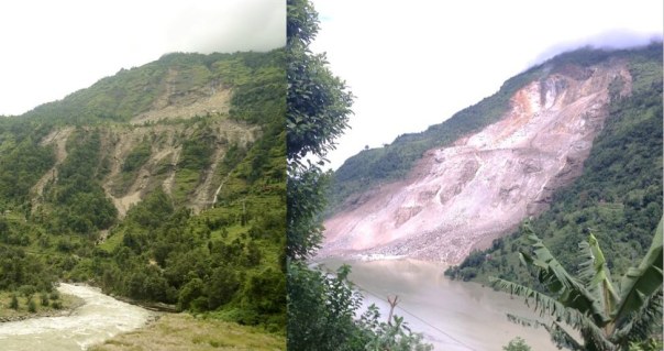
Sunkoshi Progressive Landslide: Photo of June 2013 (left) and July 2014 (right), courtesy ICIMOD
AVOIDABLE TRAGEDY? “Ajay Dixit, a water expert is as baffled as Professor Narendra Khanal at the Central Department of Geography at Tribhuvan University as to what triggered the landslide. The slope is prone to landslide as portion of debris used to fall every year. What they both knew for sure is an oversight of the government. “We totally overlooked the need to monitor such disaster-prone areas, which is not a big deal these days,” said Khanal. He said the disaster is unpredictable but mitigation measures can help avert huge loss.”
This provides some clearer picture: The landslide dam now has about 15 million cubic meters of water (much more than 6 MCM earlier estimated), that the water level is gradually reducing, it has already reduced by 3 mts from peak. “Since the landslide has not stopped completely yet, there is still the risk of Landslide Dam Outburst Flood (LDOF).” That would create BIG disaster in the downstream areas. However, there are serious doubts if the volume is 15 MCM as noted here.
Ranjan Kumar Dahal, a geologist who visited the landslide area along with Home Minister Bam Dev Gautam on Sunday, said, “If another landslide occurs in the same area, the impact could be catastrophic.” Dahal said the upper part of the mountain where the massive landslide occurred is vulnerable to more landslides. “There are cracks,” said he. “So, a little rain could lead to more landslides.”
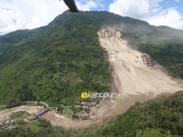
Very interesting blog from well known Nepal Journalist Kunda Dixit, it says: The landslide zone is about 1000 m high, 500 m wide and has piled up a 100 m high dam on the river bed and the impact was so huge that it has also taken forested area from opposite bank. “In 1981, nearly 20 km of the Arniko Highway and all its bridges were washed away, the Sun Kosi power house was seriously damaged and there was loss of life and property all the way down the valley. Everyone thought it was a monsoon flood, but the event was later traced to a glacial lake high up on the northern side of the Himalaya in Tibet. Like other rivers in Nepal, the Bhote Kosi is prone to glacial lake outburst floods, and geologists have found evidence of previous events in 1935 and 1964… By the time we got to Lamosangu and approached the Sun Kosi intake barrage, the road abruptly vanished at almost the exact spot near Jure where Saturday morning’s deadly landslide occurred.” The 1981 experience is based on Kunda’s reporting experience as a young reporter.
Interestingly, Kunda writes, “As night fell, the water level was down by 2m and falling.” This is good sign.
PS 17: 1830 hours IST on Aug 5, 2014: Some worrying sings:
There is a bit of worrying sign that since last 18 hours, the water flow in Sunkoshi at Pachuwarghat, which is the nearest downstream measuring point, has been almost continuously decreasing from around 401 cumecs to now around 346 cumecs (the peak y’day morning was 569 cumecs, the bottom was 214 cumecs at 17 hrs on Aug 2) when the inflow to the landslide dam as measured at Bahrabise site, the nearest upstream site is same or in fact increased. This seems to suggest that water outflow from the landslide dam has decreased and this in turn could mean more water is getting collected behind the dam. This could possibly due to more landslide fall?
It seems (see: http://www.ekantipur.com/2014/08/05/top-story/army-carries-out-controlled-blast-at-sunkoshi-river/393184.html) Nepal Army carried out another explosion today: “In an attempt to speed up the outflow of water from the dam created after landslide in the Sunkoshi River, security personnel on Tuesday carried out a controlled explosion. A temporary dam was formed in the river in Jure of Sindhupalchok district after a massive landslip early on Saturday morning, stoking fears in the human settlements downstream. Chief District Officer Gopal Prasad Parajuli said the attempt was made to drain out the water, according to the suggestions of geologists, meteorologists and other experts, after the water level in the dam did not decrease even four days after the landslide. “A low intensity blast was carried out because powerful bombs will be risky,” said Parajuli.”
Sunkoshi flowing from Landslide dam Aug 5 2014, Photo Courtesy Circle of Blue
Outflow at Pachuwarghat has increased by 31 cumecs to 377 cumecs from 6 pm to 9 pm. Flow at Bahrabise has also increased in previous six hours by 27 cumecs.
“Arun Shrestha, manager of ICIMOD’s river basin program told Circle of Blue that three main questions must be answered in the next few days: Will the hillside collapse again? What can be done to stabilize the slope? How stable is the landslide dam across the Sun Koshi River?” The nature of the dam, comprised of rock, mud, and sediment, is the greatest concern, Shrestha said. Shrestha mentioned the catastrophic June 2013 floods in Uttarakhand as another example of natural hazards limiting national hydropower plans. But cautious development in Nepal will be easier wished than accomplished, asserted Gyawali, the former water resources minister.
When asked which authorities were responsible for approving hydropower permits, Dipak Gyawali scoffed at the question. “I am afraid these questions arise in your mind conflating Nepal with Norway,” he wrote in an email. “We have a dominating informal sector where policies are made and decisions are taken at the household level. Yes, government has policies. Can they effectively implement it? Well, more easily on the moon than in next-to-inaccessible Nepali hinterlands.” If the authorities want, the Sun Koshi example can serve as a guide for hydropower development, said Gyawali, who is now research director of the Nepal Water Conservation Foundation. “These bishyaris keep happening all the time,” Gyawali said, referring to the floods from landslide dams. “Nepal is better off developing small hydropower plants across the country. If we try to build one single plant, we’re putting a larger risk on the table. Many smaller ones cannot all be knocked out.”
Petley, the Durham University landslide expert, said that more research on natural hazards in the Himalayas is needed. “The Himalayan landscape needs to be managed very carefully,” Petley said. “There is too much indiscriminate development.”
This is clearly WRONG in this report: “The hydropower stations along the river do not use large dams. Rather, they are small facilities, no more than 45 megawatts, that divert a portion of the river’s flow to generate electricity before returning it to the channel downstream.” Most of these projects have large dams and have huge impacts locally.
In late April and early May 2012, what was usually a roaring Seti river in Northwestern Nepal had slowed to a trickle. The milky-white turbid water had turned blue and clear. And then suddenly on May 5, 2012, the flooded river laden with slurry of sediment, rock, and water surged through the Seti valley in the Kaski district, obliterating dozens of homes and sweeping 72 people to their deaths. The floods waters were upto 30 m high at places. It reminded of the sequence of events leading to Tsunami. Questions swirled about where the water had come from and how it arrived with so little warning and that too in a non-monsoon season.
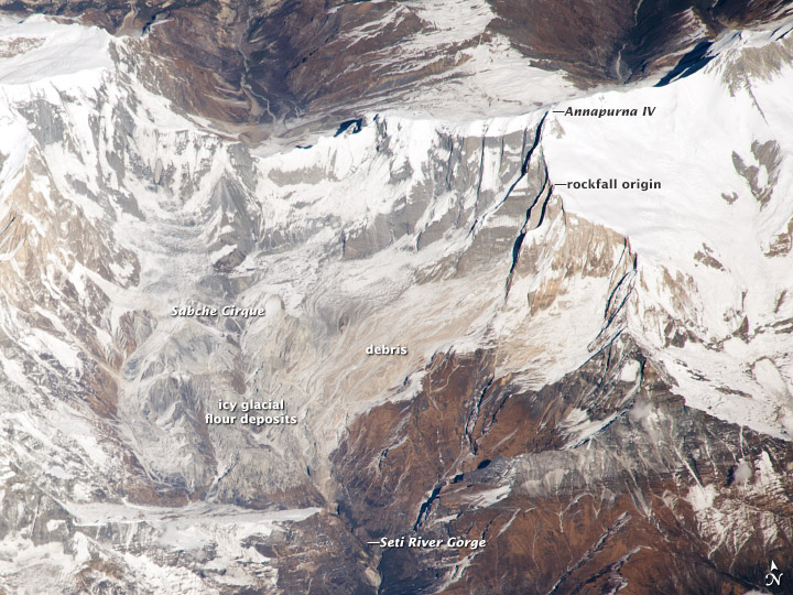
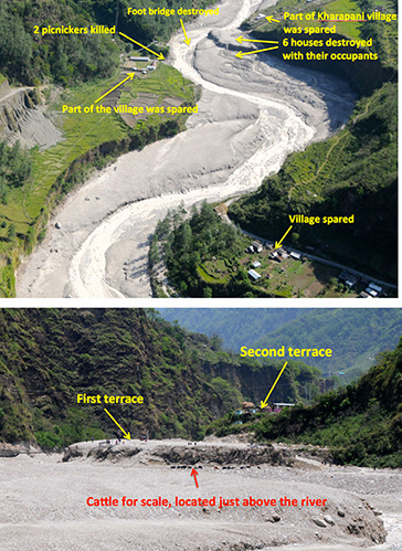
NASA Earth Observatory (acquired October 7, 2013)
The abstract of the paper by Shreekamal Dwivedi and Yojana Neupane of Department of Water Induced Disaster Prevention of Government of Nepal (presented in a conference in Nov 2012 and published in Nepal Geological Society (2013, Vol. 46)) provided some details of what happened in the floods: “Comparative Analysis of the Landsat ETM satellite images of 20th April, 2012 and 6th May, 2012 revealed that the area of about 32000 square meter of the southern ridge 1.5 kilometer away from the Annapurna IV peak failed in the north western direction. The impact of descending mass of the failed mountain from 6850 meters to 4500 meters almost vertically pulverized the ice, sediment and rock. The impact even triggered seismicity at 9:09.56 AM. local time which was recorded all over the 21 stations of National Seismological Centre. The closest seismic station at Dansing which is 32 km. south west from the area recorded the high signals for 70 minutes which corresponds to the duration of the debris flow. (The seismicity was equivalent to magnitude 3.8-4 in Richter Scale.) Lab analysis of the flood water sample revealed the density of the flow as 1.88 gm/cc. Analysis of the satellite based hourly rainfall GSMaP NRT from the period form 20th April -6th May 2012 revealed that there were just 4 occurrences of rainfall which amounted less than 1 mm/hour in the source area of the avalanche. The rainfall > 6mm/hour which occurred in the Kharapani area on 4 May was localized rainfall which did not extend to the avalanche area. Lack of systematic disaster preparedness caused huge loss of life and property even though the early warning message was received from the Ultralight pilot who was flying close to the area. The avalanche triggered high intensity floods which have similar characteristics to glacier lake outburst floods (GLOFs) have emerged as a new hazard in the Himalaya.”
Now, twenty months after the disaster, experts like Dr Jeffrey Kargel, hydrologist at University of Arizona, are in a position to throw more light what happened. Dr. Kargel has concluded that it was not just one event but a series of event that combined to produce the devastation.
NASA Earth Observatory site describes the affected landscape as: “The landscape in this part of Nepal is shaped by a cycle of landslides and subsequent erosion. As the tectonic collision of India with Asia pushes the Himalaya upward, ice, water, and gravity, assisted by sporadic earthquakes, combine to grind the mountains down. The channel of the SetiRiver itself is cut into the remnants of a much larger debris flow, perhaps 1,000 times as big. 60 to 100 meters (200–330 feet) thick, the landslide deposits are composed of the same limestone as the peaks to the north. Likewise, the May 2012 flow left behind jagged fragments of limestone, carried from the crest of the Himalaya to the foothills in a single event.”
‘Seti’ in local languages means white, and Seti is the ‘White River’, its water is glacial white, turbid and laden with sediment.
The high intensity floods in May 2012 came in waves, and the first wave alone had around a quarter of a million cubic meters of water in just a few minutes. There were about 27 waves in all over the next hours, according to eyewitnesses, so several million cubic meters of water flowed overall. As Dwivedi et al note, “The huge mass of debris along with ice chunks rushed down the river as a debris flow for 20 kilometres downstream at Kharapani in just 28 minutes (almost 12 meters/second). The flood arrived at Kharapani, where most of casualties occurred, at 9:38 AM and reached the dam of the Seti irrigation system at 10:35 AM… The high-water level at the dam weir at Pokhara was 2.15 meters. The discharge estimation based on the water mark revealed the peak as 935 m3/s (B. Poudel, personal communication). The eye-witnesses in Kharapani area reported huge ice blocks floating in the flood. They felt vibrating ground and heard very loud sound similar to flying of several helicopter together. The smell of the flood water was muddy… Kharapani was a popular spot for picnic and natural hot spring bath… Most of the causalities occurred in this area as the warning message from the Pokhara Airport tower could not reach this area”.
It is heart warming to see that many lives were saved, as Dwivedi et all write, “Capt. Alexander Maximov, the pilot of ultra-light plane of Avia Club Nepal in the morning of May 5 was in a regular sightseeing flight close to the Mountain Machhapuchhre. He noticed a huge dark cloud in the high-mountain depression (Fig. 9) and immediately turned back. He sent a message to the tower of Pokhara Airport. His quick understanding of the unusual event and timely response has saved hundreds of lives during the Seti flood of 5th May 2012. He informed the tower at 9:16 AM and the message was broadcasted through FM radio; police forces evacuated hundreds of people living and working in the bank of the Seti River. Some eye- witnesses in the field said that information about the flood was also received in Kharapani bazar by mobile calls from the people who saw the flooding in the upstream area. This message has helped many people to run to safety. However there was no organized approach of the warning dissemination in the ground.”
Video shot by Capt. Maximov from his aircraft, as the event was was happening:
NASA Earth Observatory image (acquired Dec 22 2013)
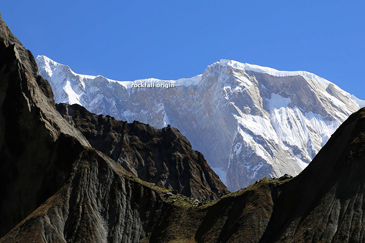
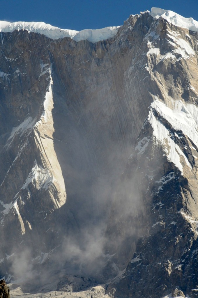
However, the series of event started weeks before the flood with a series of rockfalls that sent debris tumbling into the SetiRiver, backing water up in the extremely deep and narrow gorge. The last of these landslides occurred just a week or so before the flood. The situation grew dire on May 5, 2012, when an unusually powerful ice avalanche and rockfall tumbled down a vertical cliff on a ridge just south of Annapurna IV Mountain peak. The total drop from the Annapurna IV ridgeline to the bed of the Seti below Pokhara is about 6,100 meters (20,000 feet) spread over a distance of only 40 kilometers. The distance between the landslide dam and sight of worst floods was about 29 km.
Prof Jeffrey Kargel, writes (http://earthobservatory.nasa.gov/blogs/fromthefield/2014/01/24/setiriverclues/), “A flash flood—what geologists call a hyper concentrated slurry because it was thick with suspended silt—had torn through some villages along the Seti River, in north-central Nepal, just north of the country’s second largest city, Pokhara. It was immediately recognized as a very deadly event, but the death toll—and a tally of those who remain missing but were clearly also killed—was not known exactly for several months. 72 souls lost. Though not large on the scale of global disasters, this event was terrifying for the fact that it seemed to come from nowhere—literally from beneath a blue sky.”
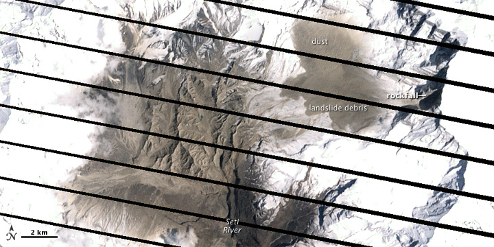
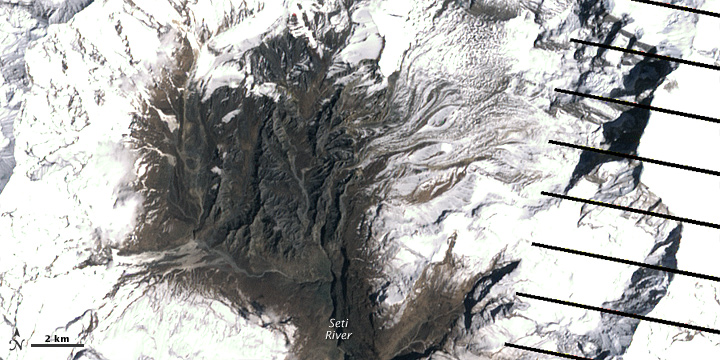
AFTER IMAGE: shows the area on May 6, 2012, roughly 25 hours after the landslide
BEFORE IMAGE: the same area on April 20. The diagonal lines are gaps in the data, due to a partial failure of the satellite.
One scenario (see: http://earthobservatory.nasa.gov/IOTD/view.php?id=78070&eocn=image&eoci=related_image) estimates that roughly 22 million cubic meters of rock broke off the slope of Annapurna IV. Colin Stark at Lamont-Doherty Earth Observatory at ColumbiaUniversity said: “There’s a drop of about 2,000 meters into the canyon, so we’re talking an enormous gain in momentum. Then I think the debris ran down the canyon at speeds upwards of 30 meters per second—a guess but what we see for the landslide itself.” Stark estimated that events unfolded in a matter of minutes with no time for a temporary dam to form.
This flood appeared to behave like a glacier lake outburst flood, and the news media can be pardoned for having assumed that it was. Prof Kargel adds: “Seeing that the disaster occurred at the foot of the AnnapurnaRange, within the Greater Himalaya, probably every expert’s first thought was “glacial lake outburst flood” (GLOF), because these were common in Nepal’s Himalaya, and the news accounts of the disaster event resembled accounts of GLOFs”. However, available satellite images showed there were no such lakes. “It was, however, clearly a disaster that had its source in a high Himalayan amphitheatre-like bowl, a glacially-carved structure called the Sabche Cirque. This structure was rimmed by some of Nepal’s most famous, picturesque mountain peaks, including the storied, holy Machapuchare ( “fishtail” peak) & Annapurna IV, a 24,688 ft” mountain.
Annotated photo from Dr. Kargel
Thanks to video from winged camera of a 2 seater plane incidentally flying over the area at the time of the event, the disaster’s trigger was sourced on a ridgeline near Annapurna IV. Apparently part of this ridge—probably initially the glacier ice— collapsed, dropping ice and rock over 3000 m almost vertically onto unconsolidated rock debris (glacial moraines and ancient glacial lake silts and gravels) resting unstably in the deep bowl of the Sabche Cirque. Some of that loose debris was also swept up by the avalanche, and the mass flowed and dropped through an additional 1,500 m into the SetiRiver gorge. Indeed, the conversion of gravitational potential energy to heat could have melted roughly a tenth of the falling snow and ice by the time it reached the SetiRiver.
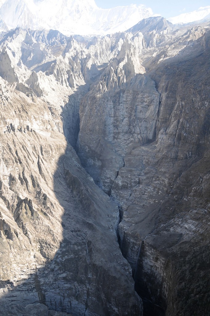
A view of the gorges and also the distant peaks of the Sabche Cirque and the ancient glacial deposits in between. The avalanche entered the gorge from the upper right corner of the scene. (Photo: Dr. Kargel)
One source seemed to be definitely involved, and that was a rockslide-dammed reservoir in the gorge. This was definitely not a GLOF, but was caused by a rockslide into the SetiRiver gorge, formation of an impoundment reservoir over a several week period due to damming of spring snow and ice melt, and then the final triggering event of the mighty rock and ice avalanche off Annapurna IV.
The source area for the avalanche of May 5, 2012. Annapurna IV is just off image to the upper left. (Photo: Dr. Kargel)
Warning: More such events could occur As Dwivedi et al have noted, “The southern slopes of Annapurna range have been experiencing avalanche-triggered high intensity floods also in the past. On August 15, 2003, the Madi River had experienced an unprecedented flash flood which destroyed the recently built rural road and triggered many landslides along its course and killed 5 people”.
“There are good reasons to be concerned,” Jeffrey says, “Something like this will happen again. It’s inevitable.” The Seti River Gorge is unusually prone to dangerous blockages because of how narrow and deep it is. And the same processes that triggered the spring 2012 rockfalls and avalanche are still at work. “The only question is whether future events will be as destructive or whether people in the SetiRiverValley will have absorbed the lessons of 2012 and found ways to move their homes out of the flood plain.” India should not forget that we are downstream country in Seti basin and what happens there will flow down here too.
In an earlier excellent paper on this event, Jorg Hanisch et al recommends that this event requires deep investigations and “Marsyangdi Khola, Madi Khola, Modi Khola and Kali Gandaki, all with apparent origin in the high-mountain environment of Annapurna Range (Hormann 1974; Yamanaka and Iwata 1982) should be included in the investigations… A new catastrophe of similar size would have an apocalyptic impact: about half a million people live in the valley today. A detailed investigation of the circumstances of the disaster on May 5th, especially the possible influence of global warming on the trigger of the disaster, and a reliable forecast of a potential recurrence of similar events or of even much greater scope, are urgently required. For this, the thorough understanding of the conditions, triggers and mechanisms of the huge flows in the past to compare it with the recent flood is indispensable as well.”
The proposal for a 140 MW Tanahu Seti storage project downstream of this flood event & supported by the Asian Development Bank, Japan International Cooperation Agency, European Investment Bank and Abu Dhabi Fund is questionable, says Ratan Bhandari of Nepal. Considering that the Seti River Basin is prone to such events in future, the proposal seems disastrous.
More significantly, this whole episode raises the question as to how much do we really know about the Himalayas. Uttarakhand disaster of June 2013 was a wake up call to understand the Himalayan ecosystem and its implications for future well being of the people and environment of India. However, in stead of learning any lessons, our governments in Uttarakhand (as also in Himachal Pradesh, Kashmir and North East) and at the Centre, with environmentally-challenged Mr Veerappa Moily as the environment minister, are playing into the hands of short sighted vested interests. This is also apparent in the recent decision to sanction the massive Lakhwar dam on YamunaRiver in Uttarakhand without so much as an Environmental Impact Assessment!
We still do not have full explanation for the Uttarakhand disaster of June 2013. This explanation of the Seti River Disaster in the same Himalayas, which happened just a year before the Uttarakhand disaster highlights the urgent need for more serious studies and applying precautionary principle while dealing with the Himalayas, its rivers and flood plains.
2. http://earthobservatory.nasa.gov/blogs/fromthefield/2014/01/24/setiriverclues/ This entry was posted on Friday, January 24th, 2014 at 10:34 am. See the absolutely amazing photos on the site that gives an insight into the situation in the head reaches of Seti River… possibly indicates how little we know about the catchments of our Himalayan Rivers.
7. “Cause and mechanism of the Seti River flood, 5th May 2012, western Nepal” by Shreekamal Dwivedi and Yojana Neupane, Department of Water Induced Disaster Prevention, Pulchwok, Lalitpur, Nepal (shreekamal @gmail.com), published in Journal of Nepal Geological Society, 2013, Vol. 46, pp. 11-18
8. Famous movie clip of the area, http://www.youtube.com/watch?v=Uk82ggshSKs&feature=related you can see landslide in the clip at 56-57 seconds of the movie. At this time the avalanche had not occurred yet. After taking one round the aircraft pilot has noticed the dark grey brown cloud formed by the avalanche (see the movie at 2 minute 7 seconds). This is thanks to Shreekamal Dwivedi
9. “The Pokhara May 5th fl ood disaster: A last warning sign sent by nature?” by Jörg Hanisch, Achyuata Koirala and Netra P. Bhandary, Journal of Nepal Geological Society, 2013, Vol. 46, pp. 1-10