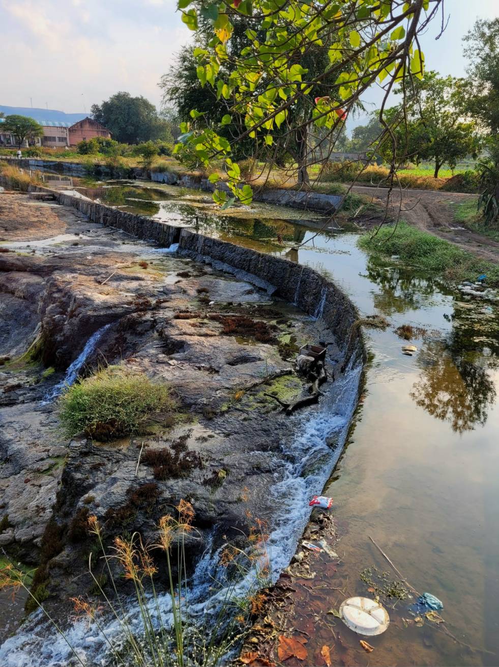
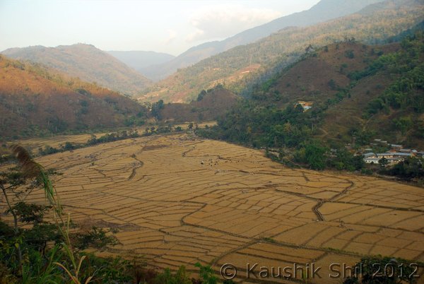
Pictures above have been taken five days apart. One would think River Interlinking entails transferring water from the bountiful right to thirsty left. In case of Damanganga-Vaitarna-Godavari Link, it means the opposite: transferring water from dry Mokhada to the verdant Devnadi in Sinnar. Like many ILR projects, it highlights the farce that is “surplus” and “deficit” basins. More rainfall does not secure water access, nor does moderate rainfall negate it.
काल दि. २३ ऑगस्ट २०१६ रोजी महाराष्ट्र-तेलंगण आंतरराज्य मंडळाच्या आज झालेल्या पहिल्याच बैठकीत तुमडीहेटी, मेडिगट्टा आणि चनाखा-कोर्टा बॅरेज या तीन बॅरेजचे काम सुरू करण्यासाठी दोन्ही राज्यांदरम्यान करार करण्यात आले. कमालीची गोपनीयता पाळत केल्या गेलेल्या या कराराबद्दलची अत्यंत मोघम टिप्पणी प्रसार माध्यमांना पाठविण्यात आली. तुमडीहेटी, मेडिगट्टा आणि चनाखा-कोर्टा बॅरेजमुळे महाराष्ट्र राज्यातील यवतमाळ, चंद्रपूर आणि गडचिरोली जिल्ह्यातील 30 हजार हेक्टर जमीन सिंचनाखाली येणार असून उपसा सिंचन योजनांना बारमाही शाश्वत पाण्याचा स्त्रोत उपलब्ध होणार आहे असे या टिप्पणीत नमूद केले आहे. तसेच या प्रकल्पामुळे महाराष्ट्रातील एकही गाव, गावठाण बुडणार नाही, नदीकाठच्या गावांना पुराचा धोका नाही व हे प्रकल्प दोन्ही राज्यासाठी फायदेशीर ठरणारे असून उपसा सिंचन योजनांना बाराही महिने पाणी मिळणार आहे असा दावा करत या भागातील नागरीकांनी या प्रकल्पांना विरोध करु नये असे आवाहनही महाराष्ट्राच्या मुख्यमंत्र्यांनी त्यांनी केले. Continue reading “महाराष्ट्र-तेलंगण आंतरराज्यीय करार: जनतेच्या मुलभूत हक्कांचे व देशाच्या पर्यावरणीय कायद्यांचे उल्लंघन”→
Maharashtra & Telangana governments, it has been announced, will be signing a pact for three irrigation projects to be constructed on River Godavari. Under the agreement, the two states would take up Tummidihatti, Medigadda (Kaleswaram) and Chanaka–Korata projects. Chief Minister of Telangana K Chandrasekhar Rao has reportedly said that “this would herald a new era in the relations between the two states and would be a standing example of how the states can resolve inter-state disputes without the Centre’s intervention.”[i]
This pact which has been looked at as ‘historical victory’ for Telangana for convincing the neighbouring states is in fact one of the most blatant and outright violations of India’s environmental laws. Tummidihetti Project & Medigadda Project featured in the agreement have long history of gross irregularities and violations exposed by several apex agencies as well as media. SANDRP has visited these project sites multiple times, studied and written extensively about the projects and also repeatedly sent submissions to Chief Minister of Maharashtra pointing out the violations. The agreement is also being signed, keeping the affected people and also people in the Godavari river basin in two states completely in the dark. Some of the links for these articles are given at the end of this article. Continue reading “Proposed Maharashtra Telangana Inter-state Water sharing Agreement of Aug 23, 2016: In complete violation of people’s rights & environmental laws of India”→
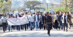
Above: Protest against Lower Subansiri Project in Assam. Basin Study of Lower Subansiri is also a part of intense debate in Assam. Now these studies are under wraps by the MoEF and CC
Non-transparent Environment Governance does not help anyone, neither is it legal. In the upcoming Expert Meeting of the MoEF and CC on River Valley Projects (read dams), documents pertaining to 6 of the 8 projects being considered are not available!
Even as the Ministry of Environment, Forests and Climate Change has been sanctioning cascades of hydropower projects on here-to free flowing rivers in the Himalaya and North East India, Cumulative Assessment of the Impacts of these projects became a crucial area of concern. Over 70 dams are planned one after other for the rivers of the Upper Ganga Basin, 44 dams across the Siang Basin in Arunachal Pradesh famed for its pristine forests and biodiversity, 12 dams across the Lohit Basin, 19 for Subansiri basin. These are bumper to bumper projects, one starting where the other ends. Continue reading “Cumulative Impact Assessment documents not in public domain anymore? Letter to MoEF and CC”→
Above: Penstock burst of Sorang Hydropower Project in Himachal Pradesh (Photo: Himdhara)
Indian government continues to have very ambitious hydropower targets, even though all the evidence suggests why we should be reviewing it. As per Central Electricity Authority, India has 42641 MW of installed capacity from large hydropower projects at the end of Dec 2015. The installed capacity from projects below 25 MW is not included in this figure.
CAPACITY ADDITION IN 2015: Troubled projects During 2015, India added 1824 MW of large hydropower capacity. Some of the important projects commissioned during the year include: 800 MW Kol Dam in Himachal Pradesh (one unit each on 30.03, 31.03, 10.04, 12.06), 450 MW Baglihar II in Jammu and Kashmir, 80 MW at Lower Jurala Project in Telangana, 330 MW Srinagar HEP in Uttarakhand and 96 MW Jorethang Loop Project in Sikkim. The first project is in Central Sector, next two in state sector and last two in private sector. Except for the 80 MW from Lower Jurala, rest of the capacity is all in Himalayan states.
What does all this show? The reason for going into above details about projects commissioned in 2015 is to illustrate how seriously problematic our decision-making has been, even in these times. Evidently, there is a need to overhaul decision making surrounding hydropower projects in vulnerable areas which face local opposition.
Are we paying any attention to this? Unfortunately, no.
To illustrate, let us look at the decisions taken by the Union Ministry of Environment and Forests’ Expert Appraisal Committee on River Valley and Hydropower Projects. All hydropower projects above 25-50 MW need clearance from this committee, as also all large irrigation projects.
EAC DECISIONS IN 2015: As our earlier analysis showed[1], the EAC has had zero rejection rate and has been clearing huge number of dams and hydropower projects, far exceeding the need, justification or carrying capacity of the river basins, with very little attention to the prudent environment governance.
During the year 2015[2], EAC continued this tradition of zero rejection rate! Even for the couple of projects that it did not agree to approve immediately, it asked for a reformulate of the proposal, keeping the options open.
During 2015, EAC recommended environment clearance to twelve projects; six of them were hydropower projects, all from Arunachal Pradesh. The biggest of them, the Kalai II project of 1200 MW showed how starkly flawed were the EAC decisions. Rest of the six were irrigation projects, including two controversial lift irrigation projects from Maharashtra (Shirapur and Krishna Marathwada) and one irrigation project each from Tamil Nadu, Odisha, Chhattisgarh and Telangana.
It should be added here, as a reminder to the decision makers, that the work at Lower Subansiri Hydropower project continued to remain stalled for the four full years as on Dec 16, 2015. This is an indication, if one was required, to show how costly the consequences of wrong decisions can be.
The EAC cleared 21 projects for first stage environment clearance, including 9 hydropower projects, two each from Arunachal Pradesh, Uttarakhand, Himachal Pradesh, Jammu & Kashmir and one from Sikkim. It also cleared four irrigation projects (one each from Rajasthan, Bihar, Jharkhand and Odisha) and eight lift irrigation projects (five from Karnataka, two from Maharashtra and one from Uttar Pradesh). It also okayed 16 applications for extension of validity for the first stage clearance, the validity, which is supposed to be for 2-3 years, went on for 4-5 years!
The EAC discussed Cumulative Impact Assessments (CIA) of Tawang, Subansiri, Siang, Dibang and Kameng river basins, all in North East India this year. Worrying, during each of these discussions it eventually approved shoddy and seriously problematic CIAs, diluted its own recommendations and refused to understand the concept of conflict of interest.
EAC did say no to first stage environment clearance to Purthi HEP in Lahaul and Spiti district in Himachal Pradesh, but gave its ok when it came back with a slightly different configuration. It did say no to extension of TOR to Lara Sumta and Sumta Kathong HEPs, but suggested they can apply afresh! It has not yet cleared Ken Betwa, Etalin and Pancheshwar, but has not said no either to any of them. It did mention SANDRP submissions dozens of times, but did not invite SANDRP, or any other group to the EAC meetings even once where SANDRP submissions and developer response were discussed. There has never been a point-wise discussion in the EAC about the merits and demerits of the developer’s response. Just to illustrate how problematic has the EAC decisions have been, see our blog about the 86th meeting of EAC held in August 2015 https://sandrp.wordpress.com/2015/09/22/why-the-decisions-and-minutes-of-the-86th-meeting-of-eac-on-river-valley-projects-need-to-be-reviewed/.
All this only goes to illustrate how seriously problematic are our decisions about dams and hydropower projects.
GENERATION PERFORMANCE OF HYDROPOWER PROEJCTS The basic purpose of building hydropower projects is generation of electricity, let us see how India’s hydropower projects perform in 2015. During the year, with total installed capacity of 42641 MW as on Dec 31, 2015, India’s large hydropower projects, as per the data from Central Electricity Authority, generated 129.11 BU (Billion Units, one unit equals one kilowatt hour), compared to 130.8 BU in 2014. So even though installed capacity in 2015 went up by 1824 MW, generation went down by 1636 Million Units! Our earlier analysis[3] has shown how the returns from hydropower projects in India are diminishing in different respects. The trend continues in 2015.
Peaking power It may be added here that USP (Unique Selling Proposition) of hydropower projects is that they can provide peaking power ( power supply in the hours when the demand is highest). There is no agency that is either monitoring or trying to optimize peaking power from hydropower projects. However, let us take a snapshot of this situation. A review of the daily Power Supply reports of the Northern Region Load Despatch Centre shows that on Dec 31, 2015, Northern region had peaking shortage of 1529 MW. Northern Region, incidentally, should give us the best illustration in this regard since it has, at 18815 MW, the highest hydropower capacity among all regions of India. On Dec 31 2015, hydropower projects were providing 10041 MW of generation during peak hours, and 2446 MW generation during off peak hours. So net peak load provided by hydropower projects on Dec 31, 2015 was 7595 MW, which is just 40% of the hydro installed capacity of 18815 MW in the region. This snapshot tells us that on Dec 31, 2015 (incidentally, the rivers have minimal flows at this time and hence all the more reason even for run of river projects to operate in peaking mode) about 60% of the hydropower capacity was NOT providing peaking power, which it was supposed to do! It may be added that Northern region had only 1529 MW of peaking shortage, which could have been easily provided by the more optimum performance of these projects. It also tells us that as far as peaking power requirement is concerned, we do not really need more hydro since the current capacity is sufficient to cater to our peaking needs, if operated optimally, in a manner that hydropower projects are supposed to operate! Even as a snapshot, this tells us a lot!
IN CONCLUSION This year end review of hydropower projects in India tells us that our decision making surrounding hydropower projects is flawed and that we can and must change the way the decision making system in functioning.
On the other hand, power generation performance of hydropower projects continue to diminish and even for peaking power requirement, we do not really need more hydropower.
[2] This review is for EAC meetings till November, the minutes of the EAC meeting of Dec 22-23, 2015 were not available till Jan 8, 2016, when I finished writing this article.
“We want sacred rivers of Tawang to flow freely, not inside Tunnels!” What makes the assertion on this banner more remarkable is the fact that the people holding it up are not fiery activists, but peace-loving Buddhist monks of the Monpa community, from the farthest corner of Arunachal Pradesh: Tawang (photo by Urmi Bhattacharjee). About 13 hydropower projects are slated to come up on main river stem and tributaries of Tawang Chhu (River) in Tawang in a distance of just 160 kms[1].
Monpa Child from Tawang Photo: tawang.nic.in
Tawang is a tiny district of Arunachal Pradesh nestled between Tibet and Bhutan. The region has had a troubled past and is home to Monpa Buddhists who practice an ancient form of Buddhism. Monpa culture itself is unique and fragile, with less than 50,000 Monpas in Tawang and less than one lakh globally. The region is famed for Tawang Monastery, Galden Namgey Lhatse (which literally means Celestial Paradise on a Clear Night), which is the 2nd largest monastery in the world. Continue reading “Cumulative Impact Assessment of Tawang Basin: Highlights from the NEHU Study”→
Even after multiple appeals by various experts, organizations and local people, Expert Appraisal Committee (EAC) set up by Ministry of Environment & Forest (MoEF) has once again chosen to ignore alarms of changing climate such as disaster of Uttarakhand in 2013 and has continued to consider Hydro Power Projects on Chenab Basin for Environmental Clearance (EC) before the Cumulative Impact Assessment of Chenab Basin has been accepted by MoEF. While on one hand the State Government of Himachal Pradesh has promptly appointed a committee headed by Chief Secretary to supervise and monitor all the progress and to “sort out” problems of getting various clearances “without delay in single window system”[i], on the other hand overall transparency of the Environmental Clearance Process has been steadily decreasing.
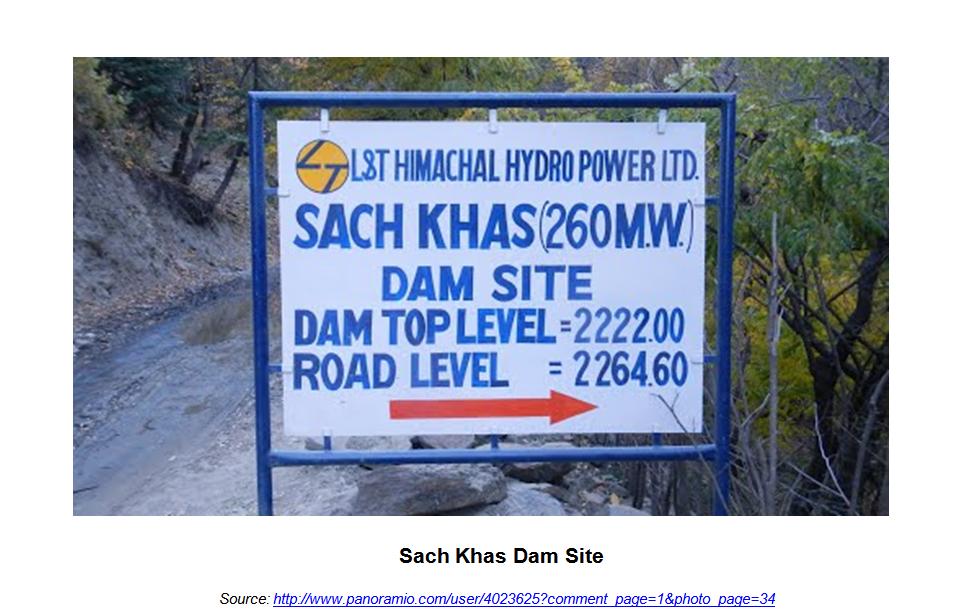
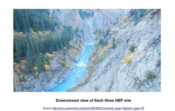
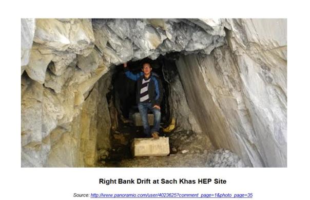
Sach Khas HEP (260 + 7 MW) (located in Chamba District of Himachal Pradesh) was considered by EAC in its 76th meeting held on August 11, 2014. Even though the project was considered for EC, no documents were uploaded on the website. Website does not even list the project under “Awaiting EC” category. This is in clear violation with MoEF norms, basic norms of transparency and Central Information Commission (CIC) orders. There are no fixed guidelines for documents to the uploaded, the time by when they should be uploaded and rules that project cannot be considered if the documents are not uploaded.
SANDRP recently sent a detailed submission to EAC pointing out several irregularities of the project. The comments were based on reading of the Environmental Impact Assessment (EIA) report available on the HP Pollution Control Board Website (which cannot be substitute for putting up the documents on EAC website). Environmental Management Plan (EMP) of the project is not accessible at all! Non availability of EMP on the HP Pollution Control Board website too is a violation of EIA notification 2006.
The EIA report which is prepared by WAPCOS is another example of a poorly conducted EIA with generic impact prediction and no detailed assessment or quantification of the impacts. Moreover since EMP is not available in the public domain, there is no way to assess how effectively the impacts have been translated into mitigation measures. Violations of Terms of Reference (TOR) issued by EAC at the time of scoping clearance is a serious concern.
Project Profile
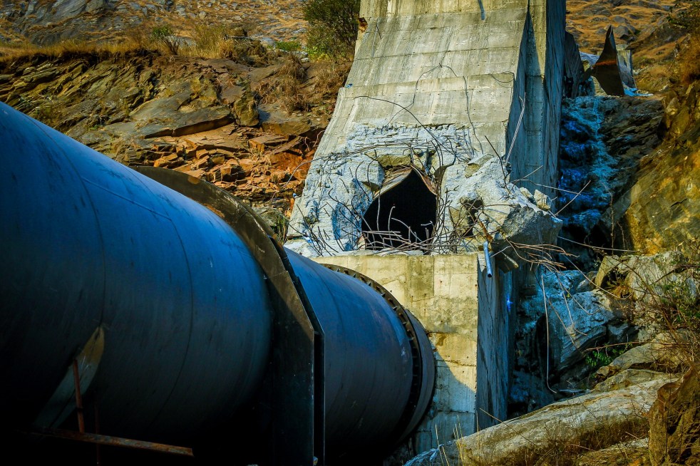
Sach Khas HEP is a Dam-toe powerhouse scheme. The project has a Concrete Dam & Spillway with Gross storage of 25.24 MCM, Live Storage of 8.69 MCM and Reservoir Stretch at FRL of 8.2 km (approx.) Three intakes each leading to 5.8m diameter penstocks are planned to be located on three of the right bank non-overflow blocks. Three penstocks offtaking from the intakes are proposed to direct the flows to an underground powerhouse on the right bank of the Chenab river housing 3 units of 86.67 MW turbines with a total installed capacity of 260 MW. The project also proposes to construct 2 units of 7 MW each to be installed to utilize the mandatory environmental releases. The EIA mentions (p 2.19) that the HP government has allocated 3.5 MW Hydropower project on Chhou Nala in the project area to the project authority, so this is integral part of the project.
Sach Khas Hydro Electric Project was considered before completion of Cumulative Impact Assessment of Chenab Basin
Chenab basin may have one of the highest concentrations of hydropower projects among all basins in India[i]. The basin has over 60 HEPs under various stages of planning, construction and commissioning in states of Himachal Pradesh (HP) and Jammu and Kashmir (J&K). 49 of these projects are planned or under construction in Chenab in HP and of which 28 projects of combined generation capacity of 5,800 MW are at an advanced stage of obtaining (Environment Ministry) clearances[ii]. MoEF sanctioned TORs for Cumulative Impact Assessment (CIA) of the HEPs on Chenab in HP in February 2012 however the project specific ECs were delinked from the CIAs[iii].
MoEFs Office Memorandum dated May 28 2013 states, “While, first project in a basin could come up without insisting on cumulative impact study, for all subsequent hydro-power projects in the basin, it should be incumbent on the developer of second/ other project(s) to incorporate all possible and potential impacts of the other project (s) in the basin to get a cumulative impact assessment done.”
We had pointed out in our submission against Kiru & Kwar projects in Jammu & Kashmir that CIA of all the proposed, under construction and operational projects and carrying capacity assessment (CCA) of the Chenab River basin to see if it can support the massive number of HEPs in safe and sustainable way is one of the first steps before considering clearances to HEPs in this region. Looking at the fragility of the Himalayan ecosystem, considering any hydropower project in the basin without these studies will be an invitation to disaster[iv]. This fact has been repeatedly highlighted by multiple organizations and experts including SANDRP.
Sach Khas EIA Study: Gross violation of TOR
The EIA violates several stipulations of TOR issued on Feb 22, 2013, which also included the stipulations of EAC in Sept 2012 and Nov 2012 meetings where the project TOR was considered and also Annexure attached with the TOR. This has severely affected the overall quality of the EIA report.
About assessing the impacts of the project on wild life the TOR said: “Reaching conclusion about the absence of such (Rare, Endangered & Threatened) species in the study area, based on such (conventional sampling) methodology is misleading” as such “species are usually secretive in behavior”, “species specific methodologies should be adopted to ascertain their presence in the study area”, “If the need be, modern methods like camera trapping can be resorted to”. None of this is shown to be done in any credible way in EIA.
TOR also recommends intense study of available fish species in the river particularly during summer (lean) months with help of experimental fishing with the help of different types of cast and grill nets. There is no evidence in EIA of any such intensive efforts detailed here. In fact the field survey in summer moths was done in May June 2010, years before the EAC stipulation.
TOR (EAC minutes of Sept 2012) state “Chenab river in this stretch has good fish species diversity & their sustenance has to be studied by a reputed institute.” This is entirely missing. TOR (EAC minutes of Sept 2012) states “During the day, the adequacy of this discharge (12 cumecs) from aquatic biodiversity consideration needs to be substantiated”. This again is missing. TOR said 10 MW secondary station may be a more desirable option. This is not even assessed. TOR said Impacts of abrupt peaking need to be assessed. This is also not done. Site specific E-Flow studies and peaking studies stipulated by TOR are missing. TOR states that Public Hearing / consultations should be addressed & incorporated in the EIA-EMP. However there is no evidence of this in the report.
TOR also required following to be included in EIA, but many of them found to be missing: L section of ALL upstream, downstream projects; Project layout showing all components with A-3 scale of clarity and 1: 50000 scale; drainage pattern map of river upto project; critically degraded areas delineated; Demarcation of snowfed/ rainfed areas; different riverine habitats like rapids, pools, side pools, variations, etc;
Contradictions in basic project parameters
The EIA report provides contradictions in even in basic parameters of the project components: So section 2.1 on page 2.1 says, “The envisaged tail water level upstream of the Saichu Nala confluence is 2150 m.” This i s when the TWL is supposed to 2149 m as per diagram on next page from the EIA. Section 2.3 says: “River bed elevation at the proposed dam axis is 2145m.” At the same time, the tail water level is 2149 m. How can Tail water level of hydropower project be higher than the river bed level at the dam site? This means that the project is occupying the river elevation beyond what HPPCL has allocated to it. Page 23 of EIA says: “…the centerline of the machines in the powerhouse is proposed at 2138.00m…” So the Centre line o the power house is full 11 m BELOW the tail water level of 2149 m? How will the water from power house CLIMB 11 m to reach TWL level?
EIA report unacceptable on many fronts
Dam ht of 70 m was stated in TOR, however the report states it to be 74 from river bed. The submergence area, consequently has gone up from 70 ha at TOR stage to 82.16 ha, as mentioned in Table 2.2 of EIA. Total land requirement which was 102.48 ha as per TOR ha has now increased to 125.62 ha, with forest land requirement going up to 118.22 ha. This is a significant departure from TOR that should be requiring fresh scoping clearance. Part of the field study has been done for the project more than four years ago and rest too more than three years ago. There are not details as to exactly what was done in field study. EAC had noted in their meeting in Sept 2012, while considering fresh scoping clearance for the project, “EIA and EMP should be carried out afresh keeping in view the drastic changes in the features due to increase in installed capacity of the power house.” (Emphasis added.) The EIA report is thus unacceptable on multiple fronts.
No cognizance of Cumulative Impacts
CIA of the entire Chenab basin including HP and J&K is not being considered, which itself is violating MoEFs Office Memorandum dated May 28 2013. The OM states that all states were to initiate carrying capacity studies within three months from the date of the OM No. J-11013/I/2013-IA-I. Since this has not happened in case of Chanab basin in J&K, considering any more projects in the basin for Environmental clearance will be in violation of the MoEF OM.
On Cumulative Impact Assessment, the OM said, “While, first project in a basin could come up without insisting on cumulative impact study, for all subsequent hydro-power projects in the basin, it should be incumbent on the developer of second/ other project(s) to incorporate all possible and potential impacts of the other project (s) in the basin to get a cumulative impact assessment done.” The EIA of both the projects does not include the cumulative impacts.
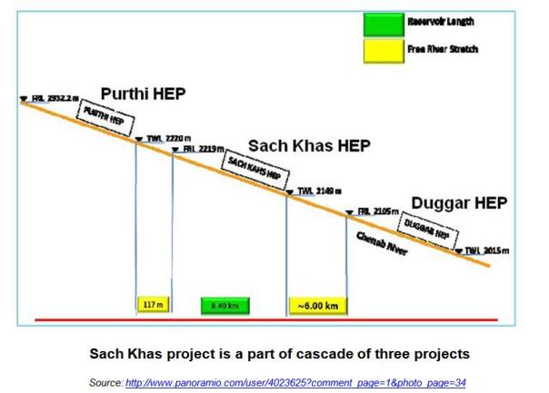
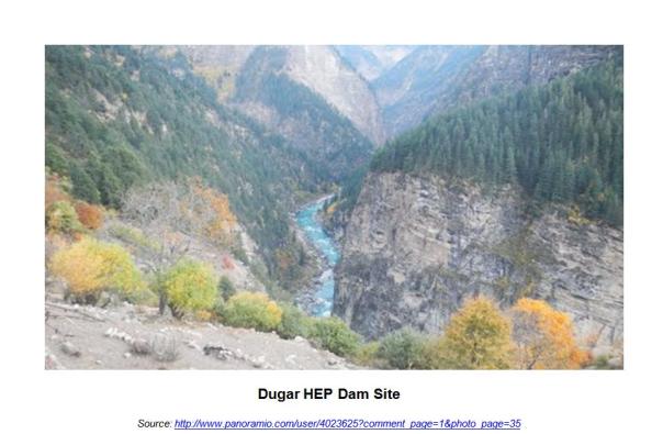
The project is located between Purthi HEP upstream and Duggar HEP downstream. Elevation difference between TWL of Purthi (2220m) and FRL of Sach Khas (2219m) is barely 1 m. The horizontal distance between them is as less as 117m. This is clearly unacceptable and in violation of the minimalist EAC-MoEF norms.
Elevation difference between TWL of Sach Khas (2149m) and the FRL of Duggar (2105 m) is 44 m and the horizontal distance is 6 km. This is thus a cascade of three among many other projects in the basin.
Even so the report does not even mention the other two projects. EIA study is project specific and no cumulative impacts are assessed along with the other two projects. The EIA does not provide a list of all the HEP projects taken up in the Chenab basin in HP state[i]. The MoEF sanctioned TORs for conducting Cumulative Impact Assessment (CIA) of Chenab In February 2012. EAC considering any further project in Chenab basin before completion of the CIA study of the basin by a credible agency (not WAPCOS) and finalised in a participatory way will be in violation of the MoEF order of May 2013.
EIA report completely misses out on the detailed analysis of cumulative impacts in terms of disaster potential of the area and how the project will increase that; impacts on flora, fauna, carrying capacity, livelihoods; cumulative downstream impact, cumulative impact of hydro peaking. impacts on springs and drainage pattern; impacts of forest diversion on environment, hydrology and society and implementation of the Forest Rights Act; changing silt flow pattern in different phases, impacts of mining, tunneling, blasting etc. Impact of reduction in adaptive capacity of the people and area to disasters in normal circumstance AND with climate change has not been assessed. Project makes no assessment of impact of climate change on the project even when over 60% of the catchment area of the project is snow-fed and glacier fed. Options assessment in terms of non dam options as required under EIA manual and National Water Policy are missing.
Generic impact prediction
Impact prediction is too generic with no detailed assessment, which is what EIA is supposed to do. Impacts have not been quantified at all. The EIA report merely states the likely impacts in 2 or 3 sentences. Several important impacts have gone missing. None of the serious impacts have been quantified. For an informed decision making and effective mitigation and EMP quantification of impacts is essentially a pre requisite. Following are some such incidences:
Impacts of blasting & tunneling: TOR for the impacts on “Socio-economic aspects” says, “Impacts of Blasting activity during project construction which generally destabilize the land mass and leads to landslides, damage to properties and drying up of natural springs and cause noise pollution will be studied.”(p.196 of EIA Report). The total area required for Underground Works is 2.44 Ha. The project proposes underground power house with an installed capacity of (260+7). There are three TRTs proposed of length 99.75m, 113.13m, and 132.35m. Even so the impacts of blasting for such huge construction are simply disregarded in the EIA report by stating that “The overall impact due to blasting operations will be restricted well below the surface and no major impacts are envisaged at the ground level.” (p.165). While assessing the impacts of blasting on wild life the report states that direct sighting of the animals has not been found in the study area and the possible reason could be habitation of few villages. No attempt has been made to assess impacts of blasting like damage to properties, drying up of springs etc. This is a clear violation of TOR.
Impacts of Peaking & diurnal flow fluctuation: In the lean season during peaking power generation the reservoir will be filled up to FRL. As stated in report, this will result in drying of river stretch downstream of dam site of Sach Khas hydroelectric project for a stretch of 6.0 km, i.e. upto tail end of reservoir of Dugar hydroelectric project. The drying of river stretch to fill the reservoir upto FRL for peaking power will last even upto 23.5 hours, after which there will continuous flow equivalent to rated discharge of 428.1 cumec for 0.5 to 2 hours. Such significant diurnal fluctuation with no free flowing river stretch will have serious impacts on river eco system. There is no assessment of these impacts. Instead the report projects this as a positive impact stating “In such a scenario, significant re-aeration from natural atmosphere takes place, which maintains Dissolved Oxygen in the water body.” This is absurd, not substantiated and unscientific.
International experts have clearly concluded that: “If it is peaking it is not ROR”[ii]. In this case the EIA says the project will be peaking and yet ROR project, which is clear contradiction in terms.
Impacts on wild life: EIA report lists 18 faunal species found in the study area. Out of them 8 species are Schedule I species and 8 Schedule II species. Even so while assessing the impacts of increased accessibility, Chapter 9.6.2 b(I) of the report mentions “Since significant wildlife population is not found in the region, adverse impacts of such interferences are likely to be marginal.” If the project has so many schedule I and II species, the impact of the project on them must be assessed in the EIA. Moreover, massive construction activities, the impacts of long reservoir with fluctuating levels on daily basis, high diurnal fluctuation and dry river stretch of 6km on wild life could be serious. But the report fails to attempt any assessment of the same.
Impacts on geophysical environment are missing: The project involves Underground Works of 2.44 Ha. This involves construction of underground powerhouse, three headrace tunnels and several other structures. This will have serious impacts on the geophysical environment of the region and may activate old and new landslides in the vicinity of the project. The report makes no detailed assessment of this. Generic comments like “Removal of trees on slopes and re-working of the slopes in the immediate vicinity of roads can encourage landslides, erosion gullies, etc.” (p.176) have been made throughout the report. Such generic statements can be found in every WAPCOS report. Such statements render the whole EIA exercise as a farce. Project specific, site specific impact assessment has to be done by the EIA. Considering that the project is situated between Purthi HEP upstream and Duggar HEP downstream, a detailed assessment of the geophysical environment and impact of all the project activities is necessary. Further since the EMP is not at all available in public domain, it is difficult to assess what measures are suggested and how effective measures to arrest possible landslides have been suggested.
No assessment for Environmental Flow Releases
TOR states that the minimum environmental flow shall be 20% of the flow of four consecutive lean months of 90% dependable year, 30% of the average monsoon flow. The flow for remaining months shall be in between 20-30%, depending on the site specific requirements (p.192). Further the TOR specifically states that a site specific study shall be carried out by an expert organization (p.193).
The TOR also mandated, “A site specific study shall be carried out by an expert organisation.” However completely violating the TOR, the EIA report makes no attempt for the site specific study to establish environmental flows. Instead it proposes to construct 2 units of 7 MW each to be installed to utilize the mandatory environmental releases. This completely defeats the basic purpose of the environmental flow releases. Such flows will help neither the riverine biodiversity, nor fish migration nor provide upstream downstream connectivity.
Socio-economic profile of the study area and Rehabilitation & Resettlement Plan are missing
TOR specifies a detailed assessment of socio-economic profile within 10 km of the study area including demographic profile, economic structure, developmental profile, agricultural practices, ethnographic structure etc. It also specifies documentation sensitive habitats (in terms of historical, cultural, religious and economic importance) of dependence of the local people on minor forest produce and their cattle grazing rights in the forest land. As per the TOR the EIA report is required to list details of all the project affected families.
Report however excludes assessment of socio economic impact of the study area. The total land required for the project is 125.62 ha, of which about 118.22 ha is forest land and the balance land 7.4 ha is private land. There are cursory mentions of habitations in the study area. Chapter 8.7 ‘Economically Important plant species’ states that in study area the local people are dependent on the forest produce such as fruits, timber, fuel wood, dyes and fodder for their livelihood. However the EIA report does not even estimate the population displaced due to land acquisition and impact of the various components of the project on livelihood of the people. Further detailed study is then out of question. This is again gross violation of TOR.
The EIA says (p. 21 bottom), “Five low level sluices with crest at 2167m of size 7.5m width and 12.3m height are proposed for flood passage. Drawdown flushing of the reservoir shall be carried out through these sluices for flushing out of the sediment entrapped in the reservoir. Detailed studies on sedimentation and reservoir flushing can be taken up at detailed planning stage.” The MDDL of the project is 2209.3 m as mentioned in the same para. This means the project envisages sediment flushing by drawdown to 2167 m (sluice crest level, the sluice bottom level wll be 12.3 m below that), about 42.3 m below the MDDL. This is clearly not allowed under PCA order cited above on Indus Treaty.
Impact of 3.5 MW Chhou Nala HEP to be constructed for the project not assessed
The EIA mentions (p 2.19) that the HP government has allocated 3.5 MW Hydropower project on Chhou Nala in the project area to the project authority, so this is integral part of the project. But the EIA does not contain any impacts of the SHP. The stream on which this is planned is extremely important for the people as drinking water schemes, irrigation Kuhls and gharats of Rai, Chhou and Thandal villages are located on this stream in the proposed project area. Thus the project will have huge impacts, but there is no assessment of these impacts. This is another glaring omission of EIA. It was shocking to read that the resident commissioner said at the public hearing that this question is not part of Environmental Public hearing, when it is very much part of it.
Public hearing report
At several places either no information is given or misleading information has been presented. For example the project representatives mis-informed the people at PH that 15-20% water will be released, when minimum water they need to release is above 20%. DFO said that soil will be spread over the muck disposal site for tree planting over it, but there is no provision of this in EIA-EMP. Many questions were provided with vague answers or no answers at all. No clear answer was given when asked if the muck dumping sites have been decided in consultation with the local people, implied answer is clearly that local people have NOT be consulted. When asked about agreements to ensure that the company implements EMP and Social Management Plan as required, there was no promise that such an agreement will be signed with the village gram sabhas. The affected people raised the issue of erosion impact of diversion tunnel, but no specific response was provided in response to this issue. When a resident of Chhou village raised the issue of vulnerability of the village to the landslides, no clear answer was given by the project developer. When the same person asked that our cremation ground is going under submergence, what is the company planning about it, the project developer replied that IF the cremation ground goes under submergence, we will think about this. This only shows that the project developer and EIA consultant have not even done an assessment of such basic aspects. The PH report accepts that close to 100 workers are already working without even basic sanitation facilities, this is clear violation of EIA notification further the EIA Agency fails to mention this.
EIA is full of cut and paste, generic statements, no actual assessments
Out of nine chapters of EIA, only the last chapter is about impacts assessments! So out of 170 pages of nine chapters, only 31 pages of chapter 9 is supposedly about impact assessment and there too mostly there is no real impact assessment, mostly only generic statements that can be included in any EIA. There are several unnecessary sections in the EIA like chapter 3 on “Construction Methodology” which is unnecessary in EIA. In most other sections too, the information is just cut and paste from DPR. By way of impact prediction, the EIA report is only listing them doing absolutely NO ASSESSMENT and no quantification of impacts is attempted. Further since the EMP is not available in the public domain, it is impossible to assess if the measures provided in the EMP are effective. Such EIA is definitely not acceptable.
No proper referencing The EIA does not provide references to the specific information, without this it is difficult to cross check which information is from which secondary sources and how credible it is and which information is from primary survey.
Conclusion
This is another most shoddy piece of EIA by WAPCOS.
Moreover, as we can see the EIA has not done several impact assessments, has violated large no of TORs on several counts, the EIA-EMP are not available on EAC website, the project parameters have undergone changes necessitating fresh scoping clearance as mentioned in TOR but that has not happened, baseline study is 3-4 years old, EAC stipulation of fresh EIA-EMP has been violated, Project is using larger riverine stretch than given by HP govt, there is no proper referencing, hydrology is weak, EMP is not available on HPPCB website in violation of EIA notification, among several other issues listed above. Every conceivable serious problem can be found in this EIA of WAPCOS.
It is full of generic statements that can be pasted in any EIA without any attempt at project specific impact assessment. SANDRP has been pointing to EAC and MoEF about such unacceptable EIA by WAPCOS for several years, but neither EAC, nor MoEF has taken any action in this regard. SANDRP has once again urged to EAC and MoEF to reject this EIA and recommend blacklisting of WAPCOS and to issue fresh scoping clearance for the project as mentioned in the TOR since the project parameters (dam height, submergence area, land requirement, etc) have gone through significant changes.
We sincerely hope the EAC will not only take serious cognition of these and not recommend clearance to the project, but also direct the project proponent and EIA consultant to implement other recommendations made above.
“We enjoy Pushing Rivers Around” –An early Hydraulic engineer in California (from Patrick McCully’s Silenced Rivers, 1996)
“We can tame the mighty rivers. We are an example of human will and endeavor”
-Sutlej Jal Viduyt Nigam Limited, damming the entire Satluj Basin in India.
“A river flowing to the sea is a waste”- a view held by several water resource developers in India
Welcome to Anthropocene [1],says James Syvitski, a leading oceanographer, geologist and hydrologist from Colorado University who has been studying subsidence of deltas.
Some scientists are now placing Anthropocene, an era marked with human interference with natural systems, at par with geological epochs like Pleistocene and Holocene. It is manifested in many ways. Rivers and associated systems like deltas and floodplains possibly have had to face the maximum brunt of the Anthropocene.
Cutting edge scientists like Prof. Syvitski who study the changes in our deltaic systems seem to reach to a common conclusion: Delta subsidence is now the main driving force for effective sea level rise for many coastal environments. This subsidence is more influential than sea level rise related to global warming and any deltas are sinking much faster than the sea level is rising.
But why are deltas sinking? What is the main reason behind this subsidence which is eating away land and making millions of people more vulnerable?
It has been established that the main reason behind delta subsidence is drastically reducing sediments reaching the delta.Studies estimate that during the past century, there has been a 94% reduction in Krishna’s sediment reaching the delta, 95% reduction from historic load in Narmada, 80% reduction in Indus, 80% reduction in Cauvery, 96% reduction in Sabarmati, 74% reduction in Mahanadi, 74% reduction in Godavari, 50% reduction Brahmani, etc.[2],[3]
But why are sediments not reaching the delta?
Almost unanimous agreement between scientists indicates that the reason behind this drastic decline in sediments is sediment retention by dams and reservoirs in the upstream[4].(Walling and Fang (2003), Vörösmarty et al., 2003; Syvitski et al.,(2005), Erisson et al, (2005), Walling (2008), K Rao et al (2010), H Gupta et al (2012) ). This has been reiterated in IPCC WG II Report, April 2014.[5]
Bhola Island in Bangladesh, eroded by Meghana River. PhotoSrestha Banerjee, Green Clearance Watch
Prof. Syvitski wrote a few words on the issue for SANDRP. He says, “A delta can form only where the sediment volume supplied from a river can overwhelm the local ocean energy (waves, tides, currents). Ocean energy is ceaseless. Engineering of our river systems, largely through the construction of upstream dams and barrages, has reduced this sediment supply. Consequently ocean energy has begun to reduce the size of our deltas, and coastal retreat is presently widespread. Deltas, once the cradle of modern civilizations, are now under threat — some deltas are in peril of lasting only the next 100 years. Sea level is rising due to ocean warming and glacier melting. Incessant mining of groundwater from below a delta’s surface, along with oil and gas extraction, further contribute to our disappearing deltas. At risk are the residences of more than 500 million people, the loss of biodiversity hotspots, major infrastructure (e.g. megacities, ports), and the rice and protein bowls of the world. Every year thousands of people drown due to storm surges and other coastal flooding. Sinking deltas are evidence of the magnitude of the human footprint on our planetary environment. We must learn to do better.” Professor J P Syvitski (U Colorado, Boulder, USA), Chair — International Geosphere-Biosphere Programme (ICSU), Executive Director, the Community Surface Dynamics Modeling System
Large reservoirs trap as much as 80% of the upstream silt. As a result, most rivers are carrying much less sediment, and some rivers (like Krishna, Indus, Nile, and Colorado) transport virtually no sediment! In the last 50 years, the combined annual sediment flux of the large Chinese rivers has been reduced from 1800 million tons (Mt) to about 370 Mt[6]mainly due to frenzied dam building. The impact of dams and reservoirs on sediment retention has been so significant that the resultant reduced sediment load represents a volume of about 730 km3, equivalent to an area of 7300 km2 assuming a 10 m thick bed[7]. Waling (2008) states that about 25 Gt/year of sediment are trapped by large dams each year. IPCC Report (Assessment Report 5, 2014) refers that 34 rivers with drainage basins of 19 million km2 in total show a 75% reduction in sediment discharge over the past 50 years due to reservoir trapping.
Delta Subsidence and Effective Sea Level Rise (ESLR)
While this delta subsidence and sediment retention has several impacts on dense delta population and coastal ecosystems which offer important services, one of the most serious impacts is its direct role in Effective Sea Level Rise. Ericsson and Vorosmarty et al, 2012[8], concluded that decreased accretion of fluvial sediment resulting from sediment retention and consumptive losses of runoff from irrigation (also due to dams) are the primary determinants of ESLR in nearly 70% of studied deltas.
More and more scientists are concluding that climate related sea level rise has a ‘relatively minor influence on delta conditions’, as compared to anthropogenic reasons. As seen above, there is an almost unanimous agreement that dams are the most important factor influencing contemporary land-ocean sediment fluxes.[9] Globally, greater than 50% of basin-scale sediment flux in regulated basins is potentially trapped in artificial impoundments of approximately 45,000 reservoirs (with dams 15 m high) (Vörösmarty et al., 2003; Syvitski etal., 2005) and sediment delivery to deltas has been reduced or eliminated at all scales.[10]Other reasons for delta subsidence include flow diversion by dams, sediment compaction due to groundwater abstraction, oil and gas exploration and mining, etc,.[11]
Deltas, formed by centuries of accretion of rich sediment, are one of the most fertile and densest populated regions across the world. It is estimated that close to half a billion people live on or near deltas, often in megacities.[12] Although constituting a mere 5% of the total landmass, coastal regions sustain almost three-quarters of the world’s population and yield more than half of global gross domestic product (Vorosmarty et al.,2009).
The direct impacts of ESLR and delta subsidence include inundation of coastal areas, saltwater intrusion into coastal aquifers, increased rates of coastal erosion, an increased exposure to storm surges, etc. These threats have implications for hundreds of millions of people who inhabit the deltaic as well as the ecologically sensitive and important coastal wetland and mangrove forests.
Already, some studies are ringing alarm bells. It is estimated that if no mitigation measures are undertaken and sediment retention continues, then by 2050, more than 8.7 million people and 28,000 km2 of deltaic area in 33 deltas studied including Ganga-Brahmaputra, Indus, Krishna and Godavari could suffer from enhanced inundation and increased coastal erosion. In addition, a larger population and area will be affected due to increased flood risk due to storm surges[13]. Conservative estimates state that delta area vulnerable to flooding could increase by 50% under the current projected values for sea-level rise in the 21st century and this could increase if the capture of sediment upstream persists and continues to prevent the growth of the deltas.[14]
The Intergovernmental Panel on Climate Change (IPCC) projects that sea level will rise by another 21 to 71 cm by 2070, with a best estimate of 44 cm averaged globally. This will further compound impacts of delta subsidence and sediment trapping.
It has been estimated that even in the case of debilitating floods, sediment has not reached rivers in the deltas.[15]In 2007–08 alone Ganges, Mekong, Irrawaddy, Chao Phraya, Brahmani, Mahanadi, Krishna and Godavari flooded with more than 100,000 lives lost and more than a million habitants displaced. Most of the deltas that suffered from floods did not receive a significant input of sediment, and this lack of sediment can be attributed to upstream damming.[16] Some studies demonstrate that storage of sediment-laden water of major flood events leads to huge sediment trapping behind mega dams.[17]
Above: Global distribution of ESLR under baseline for each of the 40 deltas studied by Ericsson et al, 2006.From Ericsson et al, 2006
Fluvial Sediments and Deltas in India
Rivers are not only conduits of water. They are a complex, moving systems carrying sediment, nutrients, organisms, ecosystems, energy, material and cultures in their wake.
There are three kinds of sediments: suspended, bed load and wash load. Here we are referring to mainly the suspended sediments in the rivers. Sediments play a significant role in the river geomorphology, defining the river channel, its shape and structure. Sediment deposits form alluvial floodplains, deltas, levees, beaches, ox bow lakes and lagoons and creeks. The sediment load and composition changes according to the river, the geological landscape it flows in, its length, flow, structure, etc. While much of the sediment is deposited by the river on its banks, the delta of the river is primarily formed of rich sediments. Through this deposition, the river may form distributaries at its mouth, like in case of Ganga, Brahmaputra or Mahanadi systems. Ganga-Brahmaputra Delta, shared by India and Bangladesh is one of the largest delta systems in the world, spanning more than 100,000 km2[18]carrying more than one billion tonnes of sediments annually.[19]
Deltaic populations in shared rivers of India, Bangladesh and Pakistan: Population of Ganga-Brahmaputra-Meghana Delta is more than 147 million people with a population density of more than 200 people per km2 (520 people per square mile), making it one of the most densely populated regions in the world . The Krishna Godavari twin deltas supports 9·26 million people inhabiting the 12,700 km2 area at 729 persons per km2, which is more than double the country’s average.[20] Cauvery delta supports 4.4 million people[21] while the Mahanadi Delta too supports millions. Only two districts of Cuttack and Jagatsinghpur have a population more than 3.7 million. (Census 2011) in addition, the contribution of deltas to economics, food production, transport, ecosystem services etc., is immense, making it a very valuable ecosystem which deserves protection. Indus Delta in Pakistan supports more than 900,000 people.
Deltas in Peril: Impact of damming on deltas in India
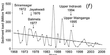
1. Krishna-Godavari Delta: In 2010, a team led by K Nageswar Rao of Dept of Geo Engineering, Andhra University, carried out an assessment of the impacts of impoundments on delta shoreline recession in Krishna and Godavari Delta.[22] The study revealed a net erosion of 76 km2 of area along the entire 336-km-long twin delta coast during the 43 years between 1965–2008 with a progressively increasing rate from 1·39 km2 per year 1965 and 1990, to 2·32 km2 per year during 1990–2000 and more or less sustained at 2·25 km2 per year during 2000–2008.
For Krishna, flows as well as suspended sediments in the delta have nearly reached zero. Suspended sediment loads decreased from 9 million tons during 1966–1969 to negligible 0·4 million tons by 2000–2005. Syvitski et al in their 2009 assessment place Krishna in the category of “Deltas in Greater Peril: Virtually no aggradation and/or very high accelerated compaction.”
In the case of the Godavari delta, there has been almost a three-fold reduction in suspended sediment loads from 150·2 million tons during 1970–1979 to 57·2 million tons by 2000–2006. Syvistki et al classify Godavari delta as “Deltas in greater risk: reduction in aggradation where rates no longer exceed relative sea-level rise”. H Gupta et al (2012) suggest that decline in historic sediments of Godavari post damming has been as high as 74%.
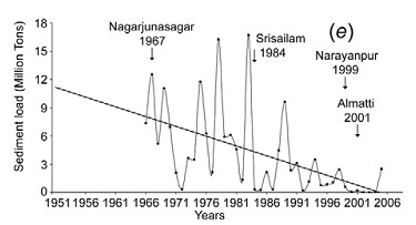
Above: Graph indicating decadal sediment and water flow trends at Prakassam Barrage, across Krishna. Dam building also marked. From Rao et al, 2010
According to Dr. Rao, a comparison of data on annual sediment loads recorded along the Krishna and Godavari Rivers shows consistently lower sediment quantities at the locations downstream of dams than at their upstream counterparts, holding dams responsible for sediment retention. Reports based on bathymetric surveys reveal considerable reduction in the storage capacities of reservoirs behind such dams. Authors say: “Sediment retention at the dams is the main reason for the pronounced coastal erosion along the Krishna and Godavari deltas during the past four decades, which is coeval[23] to the hectic dam construction activity in these river basins.”
Impacts of this can be seen in destroyed villages like Uppada in Godavari delta, destruction of Mangrove forests and shoreline. Similarly Krishna delta is losing land at the rate of 82·5 ha per year, leading to destruction of mangrove forests and loss of land.
The study concludes: “If the situation continues, these deltaic regions, which presently sustain large populations might turn out to be even uninhabitable in future, considering conditions elsewhere, such as in southern Iraq, where the farmers downstream of dams across Tigris River in Iraq, Syria and Turkey are being forced to migrate to urban centres as the reduced river flows become overwhelmed by seawater.”
I talked with Dr. Rao and asked him, if his disturbing study had any impacts. He said, no one from the administration has contacted him ever about this issue.
Above: Sediments measured at Sir. Arthur Cotton Barrage across Godavari near the Delta from Rao et al, 2010
A similar study by IWMI[24] concludes: “Coastal erosion in the Krishna Delta progressed over the last 25 years (is) at the average rate of 77.6 ha/ yr, dominating the entire delta coastline and exceeding the deposition rate threefold. The retreat of the Krishna Delta may be explained primarily by the reduced river inflow to the delta (which is three times less at present than 50 years ago) and the associated reduction of sediment load. Both are invariably related to upstream reservoir storage development.”
Krishna Basin Water Disputes Tribunal Award, though mentions dam siltation (it mentions that in 5 decades, Tungabhadra Dam has silted up to 22% of its capacity), does not say anything about flow for flushing sediments or its importance to the delta in Andhra Pradesh, or if the “minimum instream flow” recommended by the Tribunal will address this issue. This is a major limitation of the tribunal, when advanced studies have been conducted on the Krishna River delta condition and its relation to upstream dams has been established beyond doubt. Only at one place does it mention that to reduce siltation of the Almatti Dam, sluice gates should be opened when water is flowing above the crest.
However, the Award states that issues like minimum in stream flows are not decided once for all and it is an evolving process. Let us hope that there is some space to address the issue of shrinking deltas through this.
Above:Decreasing Sediments of Krishna down the years from K Rao et al, 2010
In the upstream Maharashtra, more and more dams are under construction in the Krishna Godavari Basin. One of the proposed dams called Kikvi, at the headwaters of Godavari in Trimbakeshwar was cleared by the Forest Advisory Committee recently. Ironically, the proponent (Water Resources Department, Maharashtra and Nashik Municipal Corporation) justified this dam which will submerge more than 1000 hectares of land, by stating that one more large dam close to Kikvi: Gangapur Dam is heavily silted up. [25]Rather than desilting Gangapur Dam, the administration wants to build one more dam.
Above: Trends in Sediments in Godavari and dam building activity. From K Rao et al
Many dams in Krishna Godavari Basin in Maharashtra have been criticised for not contributing to increasing irrigation.[26]These dams are not only obstructing river flow, but are also acting as sediment traps. Unfortunately, the MoEF is not even considering impacts of sediments while appraising dams. In Karnataka, major projects are being undertaken by fraud, without environmental appraisal, violating Environment laws, [27]similarly in Andhra Pradesh, many projects are being pushed illegally without environmental appraisal and which involve huge corruption[28].
2. Cauvery Delta: Although detailed studies have not been carried out, there is a clear indication of salt water intrusion and delta erosion in this over developed basin, due to upstream dams. The saline-freshwater boundary map indicates a steady migration inland.
A study by Gupta et al, 2012, indicates that historical sediment flux of Cauvery was 1.59 million tonnes, which is now 0.32 million tonnes (average of 10 years) and hence, there is a whopping 80% reduction in sediment flux of the river.
Unfortunately, the Cauvery Water Disputes Award Tribunal between Karnataka and Tamilnadu does not even mention the word ‘sediment’ in its award. There has been no justification for 10 TMC feet (Thousand Million Cubic feet) water recommended by the Tribunal for Environmental purposes and its possible impact on sediment carrying (or even environment for that matter).
Pennar showed 77% reduction and Mahanadi showed 67% reduction in amount of silt reaching the delta in recent years. (Gupta et al, 2012)
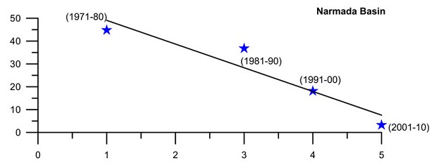
3. Narmada Delta: The west flowing rivers like Narmada and Tapi do not form extensive deltas like the east flowing rivers. Nonetheless, sediments from a huge river like Narmada play an important part in the stability of Narmada delta and villages and ecosystems around it.
Above: From: H. Gupta et al, 2007 and 2012
Gupta et al (2012 and 2007) assessed daily water discharge and suspended sediment load data measured by CWC at two gauging stations, one upstream of the Sardar Sarovar dam (Rajghat), and another downstream of the dam (Garudeshwar).
Historical sediment discharge of Narmada was found to be 61 million tonnes and the current sediment discharge (average of last ten years of the study) was found to be 3.23 million tonnes, indicating a reduction of 95% sediment discharge.[29] The presence of dam reduces 70–90% of coarse and approximately 50% of medium-sized particles on their way downstream, allowing them to settle in the reservoir Comparative studies of average suspended sediment load at various locations on the Narmada River for more than two decades, show overall reduction in suspended sediment load in the river.
The study indicated 96% reduction in suspended silt flux in Sabarmati, 41% reduction in Tapi and 68% in Mahi.
4. Ganga- Brahmaputra Delta: Different studies put different values for individual and combined sediment load of the Ganga Brahmaputra system, which carries one of the highest sediment loads in the world. According to Islam (1999)[30] Ganges and Brahmaputra rivers in Bangladesh transport 316 and 721 million tonnes of sediment annually. Of the total suspended sediment load (i.e. 1037 million tonnes) transported by these rivers, only 525 million tonnes (c. 51% of the total load) is delivered to the coastal area of Bangladesh and the remaining 512 million tonnes are deposited within the lower basin, offsetting the subsidence. Of the deposited load, about 289 million tonnes (about 28% of the total load) is deposited on the floodplains of these rivers. The remaining 223 million tonnes (about 21% of the total load) is deposited within the river channels, resulting in aggradation of the channel bed at an average rate of about 3.9 cm/yr sediment.
Across the 20th Century, Syvitski et al suggest about 30% reduction of silt load in the river system. Gupta et al [31] suggest that the observed decrease in sediment load could be due to construction of several mega dams in the Ganga basin, closure of Farakka barrage (1974) and diversion of sediments laden water into the Hooghly distributary. They also caution that dams in Ganga and Brahmaputra can worsen the situation.
5. Indus Delta: Inam et al (2007) assessed annual sediment loads of the Indus river at Kotri Barrage (270 km upstream from river mouth) during the last 73 years. The study indicates that annual sediment load of the Indus river has reduced drastically from 193 Mt (between 1931 and 1954) to 13 Mt (between 1993 and 2003). According to them, construction of three large dams on the Indus river, namely Kotri Barrage, Mangla and Terbela led to this situation causing annual water discharge to reduce from 110 km3 to 37 km3, with disastrous impacts on the delta ecosystem and population.
Above: Variation of water and sediment discharge below Kotri Barrage in Indus basin: Inam et al
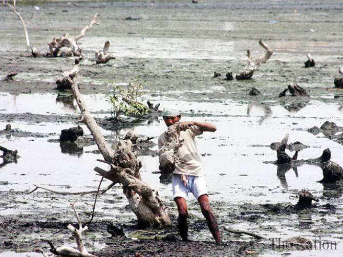
Dying mangroves in Indus Delta Photo: The Nation
Inam states : “Currently the Indus river hardly contributes any sediment to the delta or Arabian Sea.The active delta is reduced from 6200 km2 before construction of dams to 1200 km2. The sea water has travelled upstream upto 75 kms, combined loss of freshwater and sediment has resulted in loss of large areas of prime delta agricultural land and submergence of several villages in the coast. This has caused desertification and displacement of several hundred of thousands of local residents. Study of records and bathymetric maps from 1950 indicate widespread coastal retreat…The life on the delta is dependent on availability of freshwater and sediment. Severe reduction of both as a result of dams and barrages and associated structures in the upstream has resulted in pronounced erosion in parts of the delta and reduction in mangroves. Environmental studies to be extended to the entire Indus ecosystem from the mountains to the Arabian sea.”
Conclusions
It is clear that deltas and dependent populations and ecosystems have suffered due to near total ignorance about the impact of dams on sediment and deltas and if immediate action is not taken then, this will impact a huge population and a large eco-region in Indian subcontinent, as elsewhere.
The impacts of nutrient rich sediment retention and flow reduction is not limited to teh delta, but has also affected marine fish production[32]
The issue of impact of a dam on the sediment regime of the river is not being studied or considered at all while conducting Environmental Impact Assessments of projects, appraising the project for options assessment, environmental clearance, cost benefit analysis or through post clearance monitoring and compliance.
Sediment release and sediment transport through rivers is not being raised in trans-boundary river negotiations.
Looking at the severity of the issue and its far reaching impacts on millions of people in India and across the world, there is a need for adopting urgent and strong mitigation measures against sediment trapping in dams.
It has to be remembered that for older dams, older hydropower projects and most irrigation projects, there is no mechanism available to flush the accumulated silt.
Sediment retention also reduces the life of the dam, while starving the river and delta in the downstream of sediment. As per a study by SANDRP in 2006, India may be losing 1.95 Billion Cubic Meters of Storage capacity of its reservoirs annually.[33] This implies that the rivers are losing at least that quantity of sediment annually.
The frantic dam activity in Indian Himalayas at this moment will have a serious impact on Ganga Brahmaputra Delta in India and Bangladesh and Indus Delta in Pakistan. There is an urgent need to, firstly, acknowledge these links, assess the impacts, include them in cost benefit and options assessment, address the issues and implement mitigation measures, where relevant, abandon the projects where impacts are unacceptable projects unviable.
In case of the Ganga Brahmaputra delta, recent studies have indicated that the main source of sediment in the river is the Himalayas[34]. Of the entire sediment load of Ganga catchment (This study assumed it to be 794 million tonnes/year), 80+/-10 % comes from High Himalayas and 20+/-10 % comes from Lesser Himalayas.
Bumper to bumper dam/ hydropower project building is occurring in almost all of the Himalayan states in India, which is poised to make Indian Himalayas most densely dammed region in the world. All of these dams are located in the downstream of the Greater and straddling Lesser Himalayas and can together have a tremendous impact on Ganga’s sediment load. Uttarakhand is planning and building nearly 336 Hydroelectric projects,[35]while Sikkim and Himachal Pradesh too are building hundreds of hydro projects. Arunachal Pradesh intends to dam most of its rives to produce hydropower.
No studies on impact of these projects on sediment regime of the rivers are being carried out for; neither does the MoEF insist that projects will not be cleared unless such studies are carried out. Even Cumulative impact assessments are not assessing this aspect.
Some stark examples:
The Cumulative Impact Assessment Report of the Upper Ganga Basin in Uttarakhand [36](where more than one hundred dams are planned and under construction back to back) was doen by IIT Roorkee. This cumulative impact assessment did not study any cumulative impacts due to reduced silt load of the river following major dam push.
The Lohit Basin Study done by WAPCOS[37]which involves more than 12 dams across the Lohit River, one of the three main segments that form Brahmaputra, does not mention anything about impacts of dams on sediments. The only thing it states is very worrying : “Due to substantial storage capacity, the Demwe Upper reservoir will have high sediment retention capacity and a large proportion of sediments carried by the Lohit River will get settled in the reservoir.”
Siang Basin Study [38](by RS Envirolinks Pvt Limited), which involves three mega dams across the main stem Siang, completely obliterating free flowing stretches in the river,in addition to 42 hydropower dams, does not mention anything about sediment regime, although being specifically asked to address this issue by the Expert Appraisal Committee, Union Ministry of Environment & Forests (MoEF).
1500 MW Tipaimukh Mega Dam near Bangladesh Border, which has received Environmental Clearance from MoEF does not study the impacts of sediment retention on downstream Bangladesh, and this concern has been raised by the groups in that country. The Environment Management Plan of this project which can submerge 25000 hectares of forests does not even mention the word “sediment”.
The bumper to bumper dam building activity in Himachal Pradesh in Satluj, Beas, Chenab and Ravi [39]rivers will have a major impact on silt load reaching the Indus river Basin and the Indus Delta in Pakistan. However, none of the EIAs or EMPs mention any impact of the dams on the sediment regime of the river.
In conclusion, although the risks of delta subsidence, effective sea level rise and its impact on a huge population and ecosystems has been established, these risks are being entirely ignored in the current governance surrounding rivers and deltas.
National Centre for Sustainable Coastal Management It is unfortunate to see that MoEF’s National Centre for Sustainable Coastal Management, supported by MoEF and World Bank does not allude to this issue or raise it through any publications.[40] In conversation with SANDRP, Director R. Ramesh said that the center may look at these issues in the future. However, its publications on National Assessment of Shoreline Changes on Tamilnadu and Odisha[41] do not mention upstream dams, although robust evidence exist that Cauvery delta and Mahanadi, Brahmani and Baitarni deltas are eroding due to sediment retention. Let us hope this institute will try to highlight the impact of dams on deltas with the seriousness it deserves.
Recommendations
1. Urgently study impacts of sediment retention by dams on delta population and ecosystems: MoEF, Ministry of Rural Development and Urban Development should conduct an in-depth study to understand the scale of the problems and the extent of affected people and ecosystems due to sediment impoundment by upstream dams.
2.Urgently study the optimal level of sediments (and water regime) needed for stabilising deltas and reducing subsidence.
3. Urgently institute a study to assess the extent of sediment and flows needed to be released from upstream dams and feasibility of such releases on regular basis, mimicking the river’s hydrograph. Where dams have sluice gates, these should be opened in monsoons where feasible, to allow sediment flushing. Even in dry and stressed river basins like Colorado in the United States, such high releases for redistributing sediments have been conducted in the 1990s and again in 2013 with proper planning and impact assessment.[42]
4. In Krishna and such other basins, where delta subsidence, coastal erosion and related impacts like salinity intrusion and storm surges has reached serious proportions, specifically problematic dams should be considered for decommissioning.
Environmental Appraisal Process
Study of impact on sedimentation and siltation should be a part of the environmental impact assessment, environmental appraisal and clearance process.
There should be a separate section in EIA for e-flows and sedimentation studies. Similarly such studies should be mandatory part of cumulative impacts, carrying capacity and basin studies.
More dams in basins which support large deltaic populations and those having significant impacts of sediment retention by reservoirs should not be cleared.Let us hope that this chronically neglected issue receives the attention it deserves. Delta subsidence and ESLR due to upstream damming again highlights the complex and interconnected nature of the riverine ecosystem. The environmental governance in India ( as also South Asia) surrounding rivers has been treating rivers with an extremely piecemeal approach. It is clear that with the herculean challeneges we face now, such an approach is no longer affordable.
~~~~
…especially in the part called Delta, it seems to me that if the Nile no longer floods it, then, for all time to come, the Egyptians will suffer – Herodotus, History, c 442 BC (stated in Patrick McCully’s Silenced Rivers)
For PDF file of this blog, see: https://sandrp.in/Shrinking_and_sinking_delta_major_role_of_Dams_May_2014.pdf
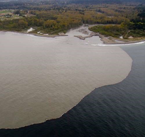
Above: Sediment laden waters of River Elwha reaching the coastal waters after Elwha Dam Removal. From: gallery.usgs.gov
Bibliography
Patrick McCully, Silenced Rivers: The Ecology and Politics of Large Dams, Zed Books, 1996
Islam et al, The Ganges and Brahmaputra rivers in Bangladesh: basin denudation and sedimentation, Hydrological processes, 1999
R.J. Wasson, A sediment budget for the Ganga–Brahmaputra catchment, Current Science, 2003
B Hema Mali et al, Coastal erosion and habitat loss along the Godavari Delta Front: a fallout of dam construction (?), Current Science, 2004
Syvitski et al, Impact of Humans on the Flux of Terrestrial Sediment to the Global Coastal Ocean, 2004
Jason P. Ericsson, Charles J. Vörösmarty S. Lawrence Dingmanb,2Larry G. Ward Effective sea-level rise and deltas: Causes of change and human dimension implications, 2006
Michel Meybeckve et al Sea-level rise and deltas: Causes of change and human dimension implications
Inam et al The Geographic, Geological and Oceanographic Setting of the Indus River, Wiley and Sons, 2007
Walling et al, The Changing sediment loads of world’s rivers, Annals of Warsaw University of Life Sciences, 2008
Syvitski et al, Sinking deltas due to human activities, Nature Geoscience, 2009
Gamage et al. Do river deltas in east India retreat? A case of the Krishna Delta, Geomorphology, Volume 103, Issue 4, 15 February 2009
K Nageswar Rao et al Impacts of sediment retention by dams on delta shoreline recession: evidences from the Krishna and Godavari deltas, India, Earth surface processes and landforms, 2010
James Syvitski et al, Sediment flux and the Anthropocene published 31 , doi: 10.1098/rsta.2010.0329 369 2011 Phil. Trans. R. Soc. A, January 2011
H Gupta et al , The role of mega dams in reducing sediment fluxes: A case study of large Asian rivers, Journal of Hydrology, 2012
[6] The role of mega dams in reducing sediment fluxes: A case study of largeAsian riversHarish Guptaa,⇑, Shuh-Ji Kaoa,b, Minhan Daia
[7] Sediment flux and the Anthropocene James P. M. Syvitski and Albert Kettner January 2011, published 31 , doi: 10.1098/rsta.2010.0329 369 2011 Phil. Trans. R. Soc. A
[8] Effective sea-level rise and deltas: Causes of change and human dimension implications
Jason P. Ericsona, Charles J. Vörösmartya,b,1, S. Lawrence Dingmanb,2Larry G. Ward
b, Michel Meybeckve Sea-level rise and deltas: Causes of change and human dimension implications Jason P. Ericson a,⁎, Charles J. Vörösmartya,b,1, S. Lawrence Dingmanb,2Larry G. Ward b, Michel Meybeck
[9] Walling and Fang (2003), Vörösmarty et al., 2003; Syvitski et al.,(2005), Erisson et al, (2005), Walling (2008)
[10] Syvitski et all 2009
[11] Sinking deltas due to human activities, Syvitski et al, 2009, Nature Geoscience
[12] Sinking deltas due to human activities, Syvitski et al, 2009, Nature Geoscience
[13] Ericsson et all, 2006, Effective sea-level rise and deltas: Causes of change and human dimension implications
[14] Sinking deltas due to human activities, Syvitski et al, 2009, Nature Geoscience
[15]Syvitski et al 2009
[16]Syvitski et all 2009
[17] Harish Guptaa, et al The role of mega dams in reducing sediment fluxes: A case study of large Asian rivers
[20] K Nageshwar Rao et al, 2010, Impacts of sediment retention by dams on delta shoreline recession: evidences from the Krishna and Godavari deltas, India Earth surface processes and landforms
[22] K Nageshwar Rao et al, 2010, Impacts of sediment retention by dams on delta shoreline recession: evidences from the Krishna and Godavari deltas, India Earth surface processes and landforms
[23] Time period or age
[24] Do river deltas in east India retreat? A case of the Krishna Delta Nilantha Gamage Geomorphology, Volume 103, Issue 4, 15 February 2009, Pages 533–540
Most of the major rivers in the North East India are largely free-flowing till date, which is a rarity in India and the world. Their basins are home to unbelievable ecological and cultural diversity. Main rivers in Arunachal Pradesh which form the mighty Brahmaputra are the Siang (the Yarlung Tsang Po), Dibang and Lohit, which meet at the trijunction to form Brahmaputra.
Massive hydropower projects are planned on these rivers in cascade. They will have irreversible destructive impacts on the society, forests, rivers, biodiversity, ecosystems, cultural identity and downstream Assam.
Hydropower Flood in Arunachal Pradesh Map: Neeraj Vagholikar, Sanctuary Asia
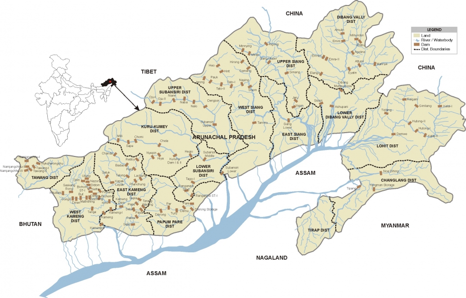
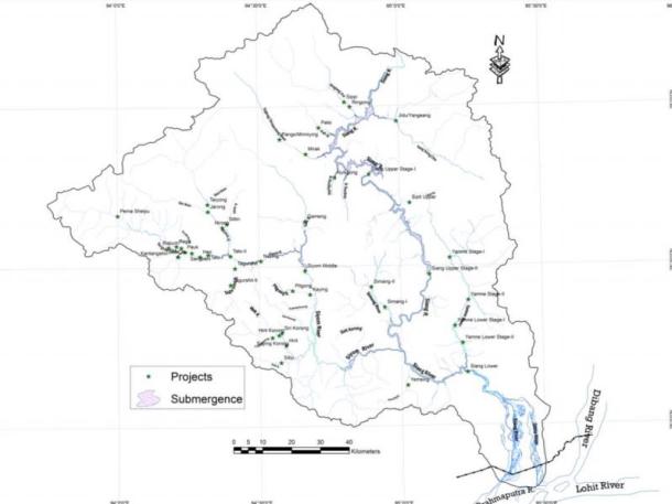
Siang River alone has 44 dams planned along its entire length.
Yes, 44 dams. You have read it correctly. At least 44 dams in one sub basin of Brahmaputra River Basin. This is what was meant by MOU virus as Jairam Ramesh described it.
Siang River Basin The Siang river originates in the Chemayungdung mountain ranges which nearly sixty miles south-east of Mansarovar lake in the Mount Kailash range in Southern Tibet at an elevation of 5300 m. A spring called Tamchok Khambab spills from the glaciers which later gather breath and volume to become the Tsangpo, the highest river in world. Tsangpo river flows 1625 km in Tibet parallel to the main range of Himalayas before entering India through Arunachal Pradesh.
Before entering India, the river passes Pi (Pe) in Tibet and suddenly turns to the north and northeast and cuts a course through a succession of great narrow gorges between the mountain Gyala Peri and Namjabarwa (Namcha Barwa) in a series of rapids and cascades. The river then turns south and southwest and flows through a deep gorge across the eastern extremity of the Himalayas with canyon walls that extends upward for 16,500 feet (5,000 meters) and more on each side.
The river enters Arunachal Pradesh near Gelling from where it is known as Siang. The total length of Siang River is 294 km till its point of confluence with Dibang and Lohit River. After entering India the river traverses approximately 197.0 km to join the Siyom river. From there the length of the river till Assam border is 86.3 km. Flowing further 10.6 km in Assam the river joins the confluence of Lohit and Dibang. From this point forward it flows as Brahmaputra river in Assam and traverses a distance of about 195 km up to the confluence of Subansiri river on its right bank. Further downstream it is joined by Kameng at Jamugurihat near Tezpur, after another 123 km. From here it travels for another 134 km up to Guwahati.
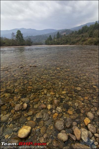
River Siang Photo from: Global Descents
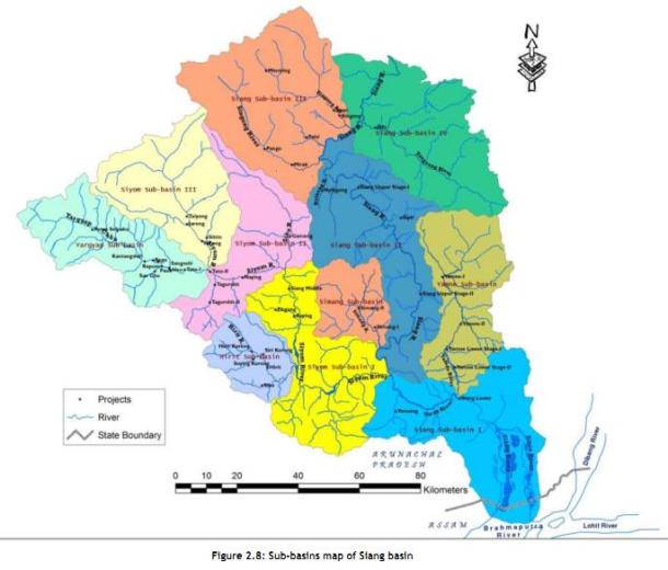
The elevation of Siang river catchment area ranges from 90 m to around 5800 m. The total catchment area of Siang river from its origin to its confluence with Lohit and Dibang rivers is 251,521 sq km. Out of this 236555.7 sq km area lies in Tibet. The total catchment area of Siang river in India upto its confluence with Lohit and Dibang rivers is 14965.30 sq km.
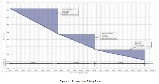
A question arises here, what will be the condition of the 294 km long Siang river if the proposed 44 dams are being built on the river. The Siang river basin study has the answer for this which is actually alarming “Only 85.5 km (29%) of free flowing water regime of Siang river will be left out of its total course in India i.e. 294 km of lotic ecosystem will be converted into 208.5 km of lentic ecosystem altering the entire Siang river aquatic system which will adversely impact the aquatic biodiversity and seriously affecting fish populations and their migration behaviour.”(page 11.23)
Three dams on the main Siang will convert the free flowing river into a three-stepped reservoir, without ANY flowing length of the river! These dams alone will affect more than 18,000 hectares of forests! If all the dams are built, water level fluctuations in the downstream D’Ering Sanctuary will be more than 23 feet every single day in the winter and other non monsoon seasons!
82.26% of the Siang basin is under forest cover (more than 15,000 sq kms), it is rich in orchids (more than 100 species!), holds 16 species of rhododendrons, 14 species of Bamboos and 14 species of canes and overall 27 RET species and 46 endemic plant species. 25 (18%) mammalian species found are Schedule I of WPA (Wildlife Protection Act), while 26 are under Schedule II! There are 447 species of birds, of which 31 are Schedule I species. The single basin consists of 5 Important Bird Areas !!(IBAs)
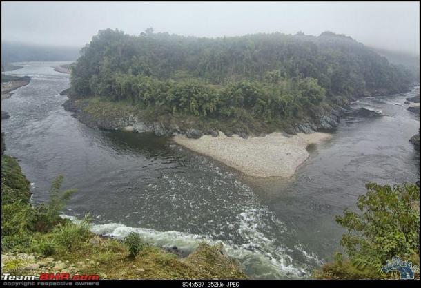
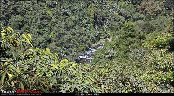
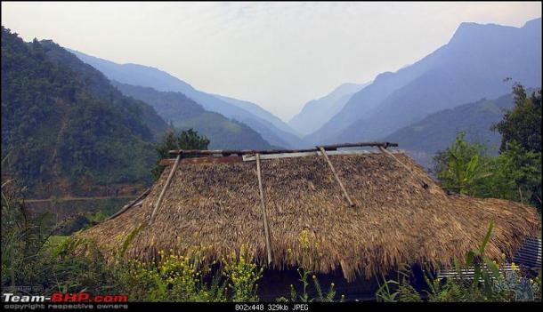
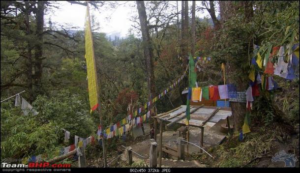
Formation of River Siyom, which will have multiple dams in a cascade Photo from: Team BHP
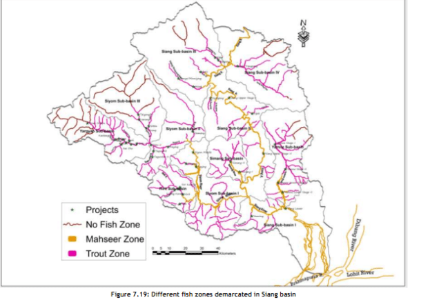
This information has been collated by the CIA (Cumulative Impact Assessment)/ CCS (Carrying Capacity Study) of the Siang Basin, which was an attempt to look at the scale and cumulative impacts of projects in Siang holistically.
Has the CIA commissioned by Central water Commission and done by RS Envirolink Technologies done an objective, scientific, independent assessment?
SANDRP sent comments about this 2-volume study with over 1500 pages to the Expert Appraisal Committee, Ministry of Environment and Forests which will be considering this basin study in its upcoming meeting on Feb 20-21, 2014. Submission below highlights that the study has very serious short comings and bias. The recommendation of dropping 15 (mostly small ones, all below 90 MW installed capacity) HEPs and re-configuring some others is welcome, but far from sufficient. The study itself is disappointing:
Projects planned in the Siang Basin Phot from CIA/ CCS of Siang Basin
Time Line of Siang Basin Study
Feb 2010
Ministry of Water Resources constituted an Inter-Ministerial Group on the directions of Prime Minister’s Office with a view to evolve a suitable framework to guide and accelerate the development of hydropower in the North East and also to assess the impact of the massive hydropower development in Arunachal Pradesh on downstream areas in Assam
Nov 2010
EAC discussed TOR for the Siang Basin CIA
Dec 23, 2010
MoEF issues TORs for the Siang Basin CIA
April 2011
EAC discusses sampling locations for the CIA on request of CWC
Dec 2011
Work of CIA for Siang awarded to RSET Pvt Ltd
May 2012
RSET says draft interim report discussed by TAC, but there is no meeting of TAC in May 2012, minutes of March and July TAC meetings (the ones before and after May 2012) on CWC website also do not mention any such discussion.
Nov 2012
EAC discusses Draft Interim report
Aug 2013
Draft Final report submitted to CWC
Sept 2013
RSET says Draft final report discussed by TAC, but the minutes of the Sept 2013 meeting of the TAC obtained under RTI donot contain any reference to the Siang basin study
DEC 2013
Draft Final Report submitted to MoEF
Feb 17, 2014
Critique of the Draft Final report submitted by SANDRP to EAC
Feb 20, 2014
MoEF’s EAC to discuss the Draft Final report
To,
Chairperson and Members,
Expert appraisal Committee
Ministry of Environment and Forests
Delhi
Subject: Serious inadequacies of Cumulative Impact Assessment (CIA) and Carrying Capacity Study (CCS) of Siang Sub-basin including Downstream Impacts
Respected Chairperson and Members,
We see from the agenda uploaded on the MoEF Website that Final Report of the Siang CIA/CCS Study commissioned by CWC and conducted by RS Envirolink Technologies Pvt Ltd will be discussed in the 72nd EAC Meeting to be held on 20-21 February 2014.
SANDRP has been analysing basin studies in the Western Himalayas and Brahmaputra Basin for some time now. Looking at the aggressive cascade hydropower development and its far reaching cumulative impacts, CIA/ CCS and Basin Studies should form the backbone of informed decision making by MoEF. Unfortunately, most studies being considered by the EAC are of a sub-standard quality and are shying away from addressing the cumulative impacts [1]. EAC itself is delinking appraisal of individual projects from basin studies, rendering the crucial process meaningless which is in violation of EIA notification of Sept 2006, wherein Form 1 Section 9 actually asks for cumulative impact assessment. Some of the recent orders of National Green Tribunal also make it CIA mandatory, thus making such delinking legally untenable.
Looking at the scale of ecological and social impacts of these projects and the significance of MoEF’s and EAC’s role, we urge the EAC to consider CIA/ CCS/ Basin Studies more seriously.
Main issues with Siang Basin Study include: (These are elaborated with reasons below)
1.No mention of social and cultural impacts!
2.Downstream impacts on Assam not studied in detail
3.Cumulative Disaster vulnerability, impact of projects on such vulnerabilities, Dam Safety Assessment, risk assessment not done
4.“Cumulative” Impacts not assessed on several aspects
5.Non-compliance with critical recommendations by the EAC:
a.Study is not compatible with similar studies done worldwide
b.No suggestions about ramping to reduce downstream impacts
c.No recommendation on free flowing length between two projects
d.No mention of cumulative impact on sediment regime
e.No mention of impact of road construction
f.BBM for eflows not used, despite agreeing to use it before EAC
g.Impact of Sand mining, boulder mining not conducted
h.Impact of specific projects not clearly studied
6.Eflows, one of the most significant issues, handled erroneously: NO ACTUAL ASSESSMENT OF E-FLOWS REQUIREMENTS AS REQUIRED BY TORs
7.No mention of Climate Change, reservoir emissions vis-à-vis cumulative impacts of such massive scale, how the projects would affect the adaptation capacity of the communities and region in the context of climate change
8.No stand taken on three mega projects on Siang Main Stem and other big hydro projects
9. No conclusion about how much length of the river is to be compromised
10. Number of sampling locations: TOR not followed
11. Source of information not given
12. Inconsistency, contradictions in listing of flora-fauna
13.Unsubstantiated advocacy: going beyond the TOR & mandate
14. Other inadequacies of CIA
15.Study should not be finalised without credible Public consultation across the basin.
Division of the Siang Basin into sub basins Phot from : CIA/ CCS Report of the Siang Basin
DETAILED CRITIQUE
1. No mention of social and cultural impacts! In the entire basin study, there is no mention of social and cultural impacts by these 44 projects which will together submerge more than 21,000 hectares of forests and affect the entire Siang Basin adversely. Needless to say, local communities depend heavily on the basin resources like fish, medicinal and food plants, timber varieties for their livelihoods. For example, more than 2000 hectares of multi-cropped, irrigated rice fields will be submerged by Lower Siang Project alone.
Adi Community that will be affected by the dams on Siang Photo with thanks from : Kaushik Shil
The CIA/CCS study needs to be re-conducted, in which social and cultural cumulative impacts are assessed with participation of local communities and downstream communities from Arunachal Pradesh and Assam. It may be remembered that Public Hearing of Lower Siang (in the latest instance, slated to be held on 31st January 2014) had to be cancelled due to a number of procedural issues, and also opposition from local residents [2]. It is incomprehensible how the CIA Study has no assessment of impacts on communities!
2. Downstream impacts on Assam not studied in detail The study assesses impacts specifically on Dibrugarh, Bokaghat (Kaziranga) and Guwahati. However, there are several villages, settlements, tea estates, agriculture, forests etc., on the Right Bank of Siang in Assam after Pasighat. This includes a major part of Dhemaji District of Assam. Impact on this region needs to be assessed. There has been opposition to Siang Dams from places like Jonai from Dhemaji, which have been ignored.[3]
Meeting protesting against Public Hearing of 2700 MW Lower Siang HEP Photo: Echo of Arunachal
According to the model used, the chainage for assessing impacts at D’Ering Sanctuary is between 20-33 kms from Lower Siang Dam. The next chainage is at 102 kms at Dibrugarh. Impacts on the stretch between D’Ering and Dibrugarh, for nearly 70 kilometres are simply not assessed! What can be reason behind this?
Level fluctuations at D’Ering Sanctuary, with Lower Siang, Middle Siyom and Upper Siang Projects is to the tune of 7.2 meters (23.66 feet!!) in lean season. This highlights the need to study impacts on the intermediate zone in Assam between Dering Sanctuary and Dibrugarh. The Study should not be accepted without these assessments.
3.Cumulative Disaster vulnerability, impact of projects on such vulnerabilities, Dam Safety Assessment, risk assessment not done
Upper Siang Stage I, Stage II and Lower Siang are huge projects with direct impact on downstream state. Even as issues of dam safety and risk assessment have gained high significance in Assam as can be seen in Lower Subansiri protests, the basin study/CIA does not include a word on dam safety, cumulative risk assessment, risk of landslips and landslides, seismic zones of projects, past earthquakes in the region, possible mitigation measures, disaster management, etc. There is no assessment of baseline situation about disaster vulnerability of the region and how the projects will change that. By its nature, a CIA/CCS/ basin study is best placed to assess these impacts.
Lanslides are a common feature of this region. Pic shows Yinkiong in Siang II Sub basin where several projects are planned. Photo: Team BHP
These points have been raised by KMSS, Assam and others. The Uttarakhand disaster of June 2013 underlines this and even the Supreme Court of India has asked for an assessment of how hydropower projects contributed to disaster in Uttarakhand. Looking at Uttarakhand Disaster as well as protests from downstream Assam where dam safety is a major issue, dam safety needs to be addressed in the CIA/ CCS. In the absence of all this, projects will not be allowed by communities, as can be seen with Lower Subansiri and Lower Siang.
4.Cumulative impacts not assessed on several aspects The study has a sketchy section (Chapter 11) on Cumulative impact assessment.
The minutes of 62nd EAC meeting noted, “The main objective of the study is to bring out the impact of dams being planned on the main Siang River and its seven tributaries on terrestrial and aquatic ecology, plant and animal biodiversity, including wild life, hydrology of the basin, etc.” (Emphasis is as in original.) However, the study has not placed emphasis on assessing these impacts.
Yar Gyap Chu: a River and basin which holds high religious significance for the Buddhists Photo: Kaushik Shil
Moreover, the study does not attempt to assess cumulative impacts of all the projects due to:
Blasting and Tunnelling: This is not mentioned even once in the entire study! When the disastrous impacts of blasting, tunnelling and related activities are fresh in our minds w.r.t Uttrakhand and Himachal Disasters, it is incomprehensible to see that this section is not mentioned at all in the basin study!
Community resources: No mention on loss of agricultural lands, homesteads, displacement, loss of forest rights, etc.
Infrastructure development: No mention of the impact of workers colonies, buildings on the society, landscape and cultural aspects, etc.
Greenhouse gas Emissions: Considering submergence of more than 20,000 hectares of dense to very dense forests and building of a large number of reservoirs in tropical climate, cumulative impacts on green house gas emissions should have been assessed.
Biodiversity, RET Species, Deforestation: While the report deals with these issues very sketchily, there is no statement as to what will be the cumulative impact of 44 projects on the above issues.
5.Non-compliance with critical recommendations by the EAC Interim basin study was discussed in the 62nd EAC meeting in November 2012. The EAC had given some important recommendations at that stage to be included in the study. However, most of the recommendations have not been complied with, these include:
Study is not compatible with similar studies done worldwide: EAC had specifically recommended compatibility with global studies. However, Siang CIA is not compatible with any global Basin and Cumulative impact Assessment Study. A Cumulative Impact Assessment is a multi-stake – holder process that assesses the cumulative and indirect impacts as well as impact interactions of the proposed dam or set of dams, as well as existing and planned projects from other sectors, on ecosystems, communities, and identified Valuable Ecosystem Components (VECs) within a specific spatial and temporal boundary. [4]
No suggestions about ramping to reduce downstream impact: EAC had specifically asked for ramping study with reference to downstream impacts. However, ramping studies are not done at all, although downstream impacts of the projects in isolation as well as together are huge.
No recommendation on free flowing length between two projects Although Upper Siang I, Upper Siang II and Lower Siang have no free flowing stretch between each other, the study refrains doing any assessments or from making any recommendations in this regard, contrary to EAC’s recommendation.
No mention of cumulative impact on sediment regime 44 projects with several mega reservoirs will have a profound impact on the sediment regime of the rivers as well as downstream impacts thereof. EAC had specifically asked to include sediment balance and impact, which is not discussed in the report.
The minutes of 62nd meeting of EAC says: “The Consultants were also asked to study and recommend on silt management considering “no dam” and “with dam” scenario as silt substantially impact the ecology and cause sedimentation particularly when its velocity is affected d/s due to construction of dam.” No such study has been conducted. In fact globally, sediment balance on cascade projects is a crucial element of study, which is completely left out in the present study.
No mention of impact of road construction Roads and related activities like deforestation, slope destabilisation, blasting, mining, muck dumping, all the cumulative impacts of peaking operation (needs to be done comprehensively, including the limitations that such operation of upstream projects will impose on downstream projects), etc have a critical impact on fragile geology. Role of roads for hydel projects was significant in Uttarakhand Tragedy in June 2013. EAC had specifically asked for “Impacts due to construction of approach roads”. This point is not touched upon in the report.
BBM for eflows not used, despite agreeing to use it in front of EAC Although the consultant agreed in the 62nd meeting that BBM will be used to assess eflows regime,[5] at the insistence of the EAC, in reality BBM has not been used in the study. The reasons given [6] that BBM is a “prescriptive approach”, “it takes too much time” and “only stakeholder in the basin is river and fish” is wrong, shocking and unacceptable.
The study forgets about the people, biodiversity and other stakeholders. Requirements of BBM were known at the time consultant agreed to use this methodology before the EAC. Is fluvial geomorphology, cultural practices, hydrological requirements and sediment balance not important blocks of BBM study?
Impact of Sand mining, boulder mining not conducted EAC had specifically asked for this study. This is critical as mining of sand and boulders from river bed has severe impact on riverine ecology, bed stability, erosion, flow velocity, etc. However, the study has not even mentioned this issue.
Yargyap Chu or the Medicinal RIver Photo: Team BHP
Cumulative Impacts of projects on biodiversity in sub-basins not clearly studied While the study has done impressive job in inventorysing ecological attributes of 11 sub basins, it has fallen woefully short in clearly communicating the individual and cumulative impacts of projects on Valued Ecosystem Components (VECs). This reduces practical application of the report. EAC had brought this up during the 62nd meeting.
Length of rivers to be assessed for downstream studies As per the minutes of the 43rd meeting of EAC held in Nov 2010 the report was to recommend: “What may be criteria for downstream impact study in terms of length of the river downstream to the tail water discharge point and what may be the parameters of such a study”.
The same EAC meeting recommended: “If the states do not change their policy of allotting elevation-wise river reaches for hydropower development, what criteria the EAC may adopt in restricting the river reach for hydropower development. Alternatively, what should be the clear river length of uninterrupted flow between the reservoir tip at FRL of a downstream project and the tail water discharge point of the immediate upstream project.”
“For peaking stations, what extent of diurnal flow variation may be considered safe for the aquatic life. There are examples where the release is drastically reduced during the long time for reservoir filling and huge discharge flows through the river during the few hours of peak power generation. This is detrimental to the aquatic environment of the downstream stretch of the river.”
“For muck disposal, what may be minimum distance that must be maintained between the outer boundary of the muck disposal sites and the river bank.”
6. Eflows, one of the most significant issues handlederroneously: NO ASSESSMENT OF E-FLOWS REQUIREMENTS The CIA has not done assessment of e-flows requirements at various locations keeping in mind the upstream projects. The very crude assumption it has made is by dividing the entire basin in Mahseer and Trout Zone and assuming certain water depths for these fish in lean, monsoon and non-lean, non-monsoon months. Several fisheries scientists do not support this classification or accept these two species alone as representing the ecosystem. The study assumes 50 cms water depth for Mahseer and 40 cms depth for Trout in lean season.[7] Then flows for maintaining that particular depth are calculated and recommended. Added criteria is that depth should not be less that 50% pre-project river depth.
Luxuriant Biodiversity of the Siang basin Photo: Team BHP
Here it is worth quoting the minutes of 62nd meeting of EAC:
“The EAC asked the Consultants to take comprehensive view of the environmental flow assessment and make final recommendations for each stretch. Committee asked to study international literature available on the subject and use the best suitable methodology for this exercise suiting to Indian conditions. The Consultants said that most appropriate method such as Building Block Methodology would be used by them. Detailed habitat simulation modelling for the entire year needs to be considered so that flow release requirement can be established not only for lean season but also for monsoon season and other months… The Consultants while submitted that public hearing as such is not a part of the study as per ToR, informed that BBM entails expert and stakeholder‟s consultations and would be followed.”
This has clearly not been done.
This approach is incorrect on various counts:
The habitat requirements of Mahseer and Snow Trout are higher than the assumed 0.5 m and 0.4 m. This has been confirmed by several fisheries scientists. The WII study on Upper Ganga Projects recommends a minimum of water depth of 1 meter for adult Mahseer (Tor species) (Table 7.6, Page 148) and at least more than 50 cms for Trouts (Schizothorax sps) (Table 7.8, Page 150). Incidentally these tables from WII Cumulative Impact Assessment have been used in the report without stating the source or credit. SANDRP has interacted with several fisheries experts who claim that 0.5 meters is a completely inadequate depth for adult Mahseer.
This faulty assumption has led to low eflows recommendations of 15% of average flows in non-lean non-monsoon months for Heo and Tato I Projects, this is lower even that EACs norms. This assessment and recommendations are clearly unacceptable.
The criteria of 50% water depth wrt pre-project depth is arbitrary and without any scientific justification. For Himalayan rivers with a stable hydrograph like Siang, 50% depth reduction is very high. As can be seen from Eflows chapter, after 50% depth reduction, most river stretches have less than 100 cms depth, which is just about the minimum depth required for an adult Mahseer or a spawning snow trout. However, Mahseer and trouts are abundant in these rivers. This just indicates the problems behind 50% water depth criteria. This should not be accepted.
The entire eflows discourse is not based on assessment of environment flows for various objectives and ignores most critical requirements.
Division of the Basin into Trout and Mahseer Zones Photo: From CIA/ CCS Report of Siang Basin
7. No mention of Climate change In the entire study, there is no mention of climate change, how changing climate would affect the rivers and projects and how project construction would add to climate change impacts and how they will reduce the adaptation capacity of the people and environment to cope with the changing climate. Deforestation to the scale of 21000 hectares of thick forests and complete loss of a biodiversity rich free flowing river has strong impacts in the context of climate change and these need to be assessed.
8. No stand taken on three mega projects on Siang Main Stem and other big hydro projects Three mega projects on Siang Main stem, namely the 6000 MW Upper Siang I, 3750 MW Upper Siang Stage II and 2700 MW Lower Siang will have a huge destructive impact on the entire ecology and society of the region. These three projects together will submerge 18,100 hectares of dense forest area and will convert entire river length between these projects: 208.5 kilometers, into unbroken sequence of reservoir-dam-reservoir-dam-reservoir-dam, with no flowing river between two consecutive projects. The study has not even attempted assessment of length of flowing river required between the projects and eflows allocation for this stretch.
L Section of the Siang River with 3 mega projects which do not leave any flowing river between them. Photo from: CIA/ CCS Report of the Siang Basin
Oppsition to Public Hearing of 2700 MW Lower Siang Project Photo: Echo of Arunachal
These projects in a cascade, destroying a complete flowing river are against the principle of sustainable development and even EAC’s minimalist norm of 1 km of flowing river between projects. A CIA/ CCS study should have raised this issue strongly as these projects are undoing most of the other recommendations. However, the study refuses to take an independent stand against these projects and fails its mandate of being an independent study.
Yamne Basin, claimed to host highest biodiversity in Siang is planned to have 4 projects back to back! Photo: Abor Country Travels
Similarly the study does not take stand on other big hydropower projects proposed in the basin. Most of the projects it has recommended to be dropped are relatively smaller projects, none are big ones. This shows bias of the consultants. The report is also not in consistent in its recommendations.
Positive suggestions: The study recommends dropping 15 projects and keeping some tributaries free from any hydel development. It also calls for including small hydel projects under the ambit of EIA. These suggestions are important and should be accepted. EAC should immediately ask MoEF to recommend changes in the EIA notifications to include all hydro projects above 1 MW.
The study has also asked for change in parameters of Tato II, Hirong, Naying and Siang Middle HEPs so that at least 1 km of river is left flowing between them. This is welcome and EAC should accordingly ask for changes in these projects. But the report has not done any study in this regard.
9. No conclusion about how much length of the river is to be compromised One of the TORs of the study include, as per the minutes of the 43rd meeting of EAC held in Nov 2010: “Considering the total length of the main river in the basin and the HEPs already existing and planned for future development, how many more HEPs may be allowed to come up. In other words, how much of the total length of the river that may be tunneled inclusive of the tunnelling requirement of all the projects that have been planned for development so that the integrity of the river is not grossly undermined.” (Emphasis added.) The report does not do an assessment on this. The B K Chaturvedi committee had recommended that not more than 50% of the river can be compromised. However, this report was to study this aspect, but has neither studied this, nor done analysis or reached any conclusion.
10. Number of sampling locations The minutes of 49th meeting of EAC held in April 2011 concluded that the number of sampling locations will be decided based on this criteria: 3 sites for project with over 1000 MW installed capacity, 2 sites for projects with 500-1000 MW installed capacity and one site for projects below 500 MW installed capacity. In addition 2-3 locations will be selected in the downstream areas.
If we go by this criteria, and considering 44 planned projects listed in the CIA, there should have been 15 locations for 5 projects with capacity 1000 MW or above, 4 for two projects with 500-1000 MW capacity and 37 for projects below 500 MW capacity, in addition to the locations in downstream areas. The CIA has not followed these directions from EAC, else sampling locations would have been about 60 and not 49 as included in the report.
11. Source of information not given Several annexures in Vol II (this too should have been put up on EAC website, but has not been, we got it from other sources), including Annex I says that it is prepared from “PREPARED FROM SECONDARY DATA & FIELD SURVEYS”, but which information has been obtained from field surveys and which information is obtained from which secondary source is not given. In absence of this it is difficult to verify the claims.
12. Inconsistency, contradictions in listing of flora-fauna
– In volume II, Annex I titled “LIST OF PLANT SPECIES REPORTED FROM SIANG BASIN”, which is supposed to include data from secondary sources and field surveys lists 1249 angiosperms and 11 gymnosperms. However, the pteridophytes listed in Annex II titled “LIST OF PLANT SPECIES RECORDED FROM DIFFERENT SUB BASINS OF SIANG DURING FIELD SAMPLING” do not find mention in Annex I or Annex III a/b/c.
– Out of 11 Gymnosperms listed in Annex I, only two figure in Annex II, rest do not get listed in any of the sub basins.
– The species Dicliptera bupleuroides and Phlogacanthus thyrsiflorus listed in Annex 1 Angiosperms do not get listed in any of the sub basins.
– Section 4.1.4 says Paphiopedilum fairrieanum is an endangered and Cymbidium eburneum is an endemic and vulnerable orchid species in Siang basin, however, these species do not get listed in any sub-basins in Annexure II or in any season in Annexure III. Same is the case with endemic orchid species of Siang basin, namely Calanthe densiflora, Dendrobium cathcartii, D hookerianum, Galeola falconeri, Liparis plantaginea and Paphiopedilum fairrieanum.
– Similarly among the Rhododendron species, threatened species like Rhododendron boothii, threatened species like Rhododendron falconeri, newly discovered and critically endangered species like Rhododendron mechukae (even though it was found in Yargyap Chhu sub basin), Rare species like Rhododendron arizelum, Rhododendron dalhousieaevar. rhabdotum,Rhododendron kenderickii, and R edgeworthii are not found in Annex II or III.
Rhododendron Species of Siang Basin Photo: Abor Country Travels
– Endemic cane species Calamus leptospadix also do not figure in Annex II or III.
– The CIA says, “The Siang basin as discussed above is also very rich in floristic resources and there are still number of areas in the basin which are either under-explored or yet to be explored”, however, a CIA is supposed to make recommendation how to ensure that such areas are explored before any more projects are taken up, but this report makes no recommendation in this regard.
– The CIA says that 17 Near Threatened (regional level) medicinal plants, 46 endemic species and additional 55 endemic species are reported in Siang basin, but CIA neither gives list of them, nor locations, how these will be affected by hydropower projects or recommendations to conserve them.
– The scope of study given in Annex 1, Vol. I says: “Preparation of comprehensive checklist of flora (Angiosperms, Gymnosperms, Lichens, Pteridophytes, Bryophytes, Fungi, Algae etc.) with Botanical and local name.” However, we do not find the local names listed.
The situation with respect to fauna species is no different, with similar inconsistencies, lack of specific sub-basin wise situations and recommendations to conserve them. This is true in case of mammals, birds, butterflies, amphibians, reptiles, inspects as also aquatic biodiversity. While the report makes some impressive general statements, but is found to be lacking in specifics mentioned above.
This sample list of inconsistencies and gaps shows that there are serious problems in these lists and the consultant should be asked to remove all these inadequacies. There is also need to get these lists peer reviewed by credible independent experts like those from WII.
13. Unsubstantiated advocacy: going beyond the TOR & mandate The CIA says in last para in section 12.3 titled “Downstream Impacts”, “Keeping the substantial storage requirement in Siang, storage projects in Siang needs to be re-configured, which may lead to merging of Siang Upper Stage I and II into single project to create storage.” There are several other such sentences in this section and elsewhere. This is uncritical acceptance of CWC assertions and is an advocacy for more storage projects in the name of flood moderation. This is clearly uncalled for in a CIA report and such uncritical acceptance of CWC assertions is also not what is expected from a CIA. In any case, this is also beyond the mandate of the CIA.
14. Other inadequacies of CIA
– The CIA does not contain the TOR, the scope of the study given Annex 1 of Vol I is not the TOR.
– 49th EAC meeting had asked for inclusion of Assam Experts in the study, but the study does not mention this.
– The 43rd EAC meeting held in Nov 2010 had asked for inclusion of assessment of the impacts of the projects on wetlands, floodplains, river morphology, sediment transport/ erosion/ deposits, impact on human activities and livelihoods and recommend necessary measures in these regard. The report mentions all these aspects, but fails to assess these impacts and make necessary recommendations.
– The Preface of the CIA claims that the TAC reviewed the draft interim report in May 2012 and draft final report in Sept 2013. We have checked the minutes of the TAC meetings and find that in May 2012 there was no TAC meeting. The 114th TAC meeting happened in March 2012 and 115th TAC meeting happened in July 2012, neither of the minutes include any mention of Siang basin study.
– The Sept 2013 meeting also did not include this report in its agenda. The report seems to be making false claims in this regard, they should be asked to provide minutes of the TAC meeting where this was discussed and what were the outcomes.
15. Study should not be finalised without credible Public consultation across the basin A comprehensive Siang Basin Study will give a cumulative picture of impacts on basin and on basin residents, including downstream population in Assam. The study is supposed to include important findings, which are separate from individual EIA reports. Even MoEF’s Strategic 12th Five Year Plan notes:
Paddy feilds in Siang Basin. Agriculture finds no place in the CIA Photo: Kaushik Shil
“Of late, the limitations of project-level EIA are being realized internationally. Project EIAs react to development proposals rather than anticipate them, so they cannot steer development towards environmentally “robust” areas or away from environmentally sensitive sites. Project EIAs do not adequately consider the cumulative impacts caused by several projects or even by one project’s subcomponents or ancillary developments. The new trend is to address environmental issues earlier in planning and policy making processes. This could be done through cumulative impact assessment.”
However, such a study cannot be complete without consultations held across the basin in a credible way with full information to the communities in the language and manner they can understand. The study should not be accepted without a credible process of Public hearing [8].
CONCLUSION We would like to urge the EAC NOT TO CONSIDER INDIVIDUAL PROJECTS UNLESS THE CIA/CCS Study is APPROVED through a participatory process. In Siang basin, the EAC has already granted EC to 2 projects, Scoping clearance to 16 projects (of which PH has been held for 8 projects) and nine projects will not need EC as they are below 25 MW. This renders the whole exercise of CIA/CCS meaningless!
We urge the EAC to consider all projects from Siang Basin only after CIA-CCS is finalised and keep the scoping and environmental clearances of projects in abeyance till then.
A good report on the Siang Basin CIA: Damn that river Author: Karthik TeegalapalliPosted on: 13 Oct, 2014: http://www.downtoearth.org.in/content/damn-river