
Most of the major rivers in the North East India are largely free-flowing till date, which is a rarity in India and the world. Their basins are home to unbelievable ecological and cultural diversity. Main rivers in Arunachal Pradesh which form the mighty Brahmaputra are the Siang (the Yarlung Tsang Po), Dibang and Lohit, which meet at the trijunction to form Brahmaputra.
Massive hydropower projects are planned on these rivers in cascade. They will have irreversible destructive impacts on the society, forests, rivers, biodiversity, ecosystems, cultural identity and downstream Assam.

Map: Neeraj Vagholikar, Sanctuary Asia
Siang River alone has 44 dams planned along its entire length.
Yes, 44 dams. You have read it correctly. At least 44 dams in one sub basin of Brahmaputra River Basin. This is what was meant by MOU virus as Jairam Ramesh described it.
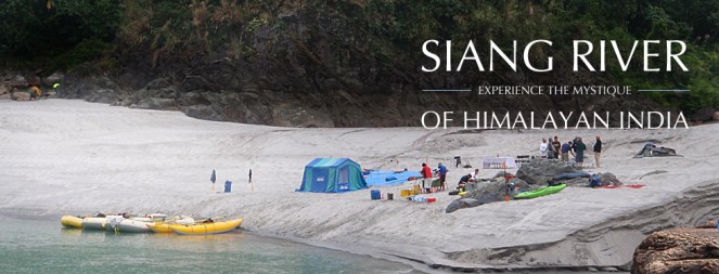
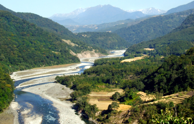
Siang River Basin The Siang river originates in the Chemayungdung mountain ranges which nearly sixty miles south-east of Mansarovar lake in the Mount Kailash range in Southern Tibet at an elevation of 5300 m. A spring called Tamchok Khambab spills from the glaciers which later gather breath and volume to become the Tsangpo, the highest river in world. Tsangpo river flows 1625 km in Tibet parallel to the main range of Himalayas before entering India through Arunachal Pradesh.
Before entering India, the river passes Pi (Pe) in Tibet and suddenly turns to the north and northeast and cuts a course through a succession of great narrow gorges between the mountain Gyala Peri and Namjabarwa (Namcha Barwa) in a series of rapids and cascades. The river then turns south and southwest and flows through a deep gorge across the eastern extremity of the Himalayas with canyon walls that extends upward for 16,500 feet (5,000 meters) and more on each side.
The river enters Arunachal Pradesh near Gelling from where it is known as Siang. The total length of Siang River is 294 km till its point of confluence with Dibang and Lohit River. After entering India the river traverses approximately 197.0 km to join the Siyom river. From there the length of the river till Assam border is 86.3 km. Flowing further 10.6 km in Assam the river joins the confluence of Lohit and Dibang. From this point forward it flows as Brahmaputra river in Assam and traverses a distance of about 195 km up to the confluence of Subansiri river on its right bank. Further downstream it is joined by Kameng at Jamugurihat near Tezpur, after another 123 km. From here it travels for another 134 km up to Guwahati.
The elevation of Siang river catchment area ranges from 90 m to around 5800 m. The total catchment area of Siang river from its origin to its confluence with Lohit and Dibang rivers is 251,521 sq km. Out of this 236555.7 sq km area lies in Tibet. The total catchment area of Siang river in India upto its confluence with Lohit and Dibang rivers is 14965.30 sq km.
A question arises here, what will be the condition of the 294 km long Siang river if the proposed 44 dams are being built on the river. The Siang river basin study has the answer for this which is actually alarming “Only 85.5 km (29%) of free flowing water regime of Siang river will be left out of its total course in India i.e. 294 km of lotic ecosystem will be converted into 208.5 km of lentic ecosystem altering the entire Siang river aquatic system which will adversely impact the aquatic biodiversity and seriously affecting fish populations and their migration behaviour.”(page 11.23)
Three dams on the main Siang will convert the free flowing river into a three-stepped reservoir, without ANY flowing length of the river! These dams alone will affect more than 18,000 hectares of forests! If all the dams are built, water level fluctuations in the downstream D’Ering Sanctuary will be more than 23 feet every single day in the winter and other non monsoon seasons!
82.26% of the Siang basin is under forest cover (more than 15,000 sq kms), it is rich in orchids (more than 100 species!), holds 16 species of rhododendrons, 14 species of Bamboos and 14 species of canes and overall 27 RET species and 46 endemic plant species. 25 (18%) mammalian species found are Schedule I of WPA (Wildlife Protection Act), while 26 are under Schedule II! There are 447 species of birds, of which 31 are Schedule I species. The single basin consists of 5 Important Bird Areas !!(IBAs)

This information has been collated by the CIA (Cumulative Impact Assessment)/ CCS (Carrying Capacity Study) of the Siang Basin, which was an attempt to look at the scale and cumulative impacts of projects in Siang holistically.
Has the CIA commissioned by Central water Commission and done by RS Envirolink Technologies done an objective, scientific, independent assessment?
SANDRP sent comments about this 2-volume study with over 1500 pages to the Expert Appraisal Committee, Ministry of Environment and Forests which will be considering this basin study in its upcoming meeting on Feb 20-21, 2014. Submission below highlights that the study has very serious short comings and bias. The recommendation of dropping 15 (mostly small ones, all below 90 MW installed capacity) HEPs and re-configuring some others is welcome, but far from sufficient. The study itself is disappointing:

Time Line of Siang Basin Study
| Feb 2010 | Ministry of Water Resources constituted an Inter-Ministerial Group on the directions of Prime Minister’s Office with a view to evolve a suitable framework to guide and accelerate the development of hydropower in the North East and also to assess the impact of the massive hydropower development in Arunachal Pradesh on downstream areas in Assam |
| Nov 2010 | EAC discussed TOR for the Siang Basin CIA |
| Dec 23, 2010 | MoEF issues TORs for the Siang Basin CIA |
| April 2011 | EAC discusses sampling locations for the CIA on request of CWC |
| Dec 2011 | Work of CIA for Siang awarded to RSET Pvt Ltd |
| May 2012 | RSET says draft interim report discussed by TAC, but there is no meeting of TAC in May 2012, minutes of March and July TAC meetings (the ones before and after May 2012) on CWC website also do not mention any such discussion. |
| Nov 2012 | EAC discusses Draft Interim report |
| Aug 2013 | Draft Final report submitted to CWC |
| Sept 2013 | RSET says Draft final report discussed by TAC, but the minutes of the Sept 2013 meeting of the TAC obtained under RTI donot contain any reference to the Siang basin study |
| DEC 2013 | Draft Final Report submitted to MoEF |
| Feb 17, 2014 | Critique of the Draft Final report submitted by SANDRP to EAC |
| Feb 20, 2014 | MoEF’s EAC to discuss the Draft Final report |
To,
Chairperson and Members,
Expert appraisal Committee
Ministry of Environment and Forests
Delhi
Subject: Serious inadequacies of Cumulative Impact Assessment (CIA) and Carrying Capacity Study (CCS) of Siang Sub-basin including Downstream Impacts
Respected Chairperson and Members,
We see from the agenda uploaded on the MoEF Website that Final Report of the Siang CIA/CCS Study commissioned by CWC and conducted by RS Envirolink Technologies Pvt Ltd will be discussed in the 72nd EAC Meeting to be held on 20-21 February 2014.
SANDRP has been analysing basin studies in the Western Himalayas and Brahmaputra Basin for some time now. Looking at the aggressive cascade hydropower development and its far reaching cumulative impacts, CIA/ CCS and Basin Studies should form the backbone of informed decision making by MoEF. Unfortunately, most studies being considered by the EAC are of a sub-standard quality and are shying away from addressing the cumulative impacts [1]. EAC itself is delinking appraisal of individual projects from basin studies, rendering the crucial process meaningless which is in violation of EIA notification of Sept 2006, wherein Form 1 Section 9 actually asks for cumulative impact assessment. Some of the recent orders of National Green Tribunal also make it CIA mandatory, thus making such delinking legally untenable.
Looking at the scale of ecological and social impacts of these projects and the significance of MoEF’s and EAC’s role, we urge the EAC to consider CIA/ CCS/ Basin Studies more seriously.
Main issues with Siang Basin Study include: (These are elaborated with reasons below)
1. No mention of social and cultural impacts!
2. Downstream impacts on Assam not studied in detail
3. Cumulative Disaster vulnerability, impact of projects on such vulnerabilities, Dam Safety Assessment, risk assessment not done
4. “Cumulative” Impacts not assessed on several aspects
5. Non-compliance with critical recommendations by the EAC:
a. Study is not compatible with similar studies done worldwide
b. No suggestions about ramping to reduce downstream impacts
c. No recommendation on free flowing length between two projects
d. No mention of cumulative impact on sediment regime
e. No mention of impact of road construction
f. BBM for eflows not used, despite agreeing to use it before EAC
g. Impact of Sand mining, boulder mining not conducted
h. Impact of specific projects not clearly studied
6. Eflows, one of the most significant issues, handled erroneously: NO ACTUAL ASSESSMENT OF E-FLOWS REQUIREMENTS AS REQUIRED BY TORs
7. No mention of Climate Change, reservoir emissions vis-à-vis cumulative impacts of such massive scale, how the projects would affect the adaptation capacity of the communities and region in the context of climate change
8. No stand taken on three mega projects on Siang Main Stem and other big hydro projects
9. No conclusion about how much length of the river is to be compromised
10. Number of sampling locations: TOR not followed
11. Source of information not given
12. Inconsistency, contradictions in listing of flora-fauna
13. Unsubstantiated advocacy: going beyond the TOR & mandate
14. Other inadequacies of CIA
15. Study should not be finalised without credible Public consultation across the basin.

DETAILED CRITIQUE
1. No mention of social and cultural impacts! In the entire basin study, there is no mention of social and cultural impacts by these 44 projects which will together submerge more than 21,000 hectares of forests and affect the entire Siang Basin adversely. Needless to say, local communities depend heavily on the basin resources like fish, medicinal and food plants, timber varieties for their livelihoods. For example, more than 2000 hectares of multi-cropped, irrigated rice fields will be submerged by Lower Siang Project alone.

The CIA/CCS study needs to be re-conducted, in which social and cultural cumulative impacts are assessed with participation of local communities and downstream communities from Arunachal Pradesh and Assam. It may be remembered that Public Hearing of Lower Siang (in the latest instance, slated to be held on 31st January 2014) had to be cancelled due to a number of procedural issues, and also opposition from local residents [2]. It is incomprehensible how the CIA Study has no assessment of impacts on communities!
2. Downstream impacts on Assam not studied in detail The study assesses impacts specifically on Dibrugarh, Bokaghat (Kaziranga) and Guwahati. However, there are several villages, settlements, tea estates, agriculture, forests etc., on the Right Bank of Siang in Assam after Pasighat. This includes a major part of Dhemaji District of Assam. Impact on this region needs to be assessed. There has been opposition to Siang Dams from places like Jonai from Dhemaji, which have been ignored.[3]
According to the model used, the chainage for assessing impacts at D’Ering Sanctuary is between 20-33 kms from Lower Siang Dam. The next chainage is at 102 kms at Dibrugarh. Impacts on the stretch between D’Ering and Dibrugarh, for nearly 70 kilometres are simply not assessed! What can be reason behind this?
Level fluctuations at D’Ering Sanctuary, with Lower Siang, Middle Siyom and Upper Siang Projects is to the tune of 7.2 meters (23.66 feet!!) in lean season. This highlights the need to study impacts on the intermediate zone in Assam between Dering Sanctuary and Dibrugarh. The Study should not be accepted without these assessments.
3. Cumulative Disaster vulnerability, impact of projects on such vulnerabilities, Dam Safety Assessment, risk assessment not done
Upper Siang Stage I, Stage II and Lower Siang are huge projects with direct impact on downstream state. Even as issues of dam safety and risk assessment have gained high significance in Assam as can be seen in Lower Subansiri protests, the basin study/CIA does not include a word on dam safety, cumulative risk assessment, risk of landslips and landslides, seismic zones of projects, past earthquakes in the region, possible mitigation measures, disaster management, etc. There is no assessment of baseline situation about disaster vulnerability of the region and how the projects will change that. By its nature, a CIA/CCS/ basin study is best placed to assess these impacts.

These points have been raised by KMSS, Assam and others. The Uttarakhand disaster of June 2013 underlines this and even the Supreme Court of India has asked for an assessment of how hydropower projects contributed to disaster in Uttarakhand. Looking at Uttarakhand Disaster as well as protests from downstream Assam where dam safety is a major issue, dam safety needs to be addressed in the CIA/ CCS. In the absence of all this, projects will not be allowed by communities, as can be seen with Lower Subansiri and Lower Siang.
4. Cumulative impacts not assessed on several aspects The study has a sketchy section (Chapter 11) on Cumulative impact assessment.
The minutes of 62nd EAC meeting noted, “The main objective of the study is to bring out the impact of dams being planned on the main Siang River and its seven tributaries on terrestrial and aquatic ecology, plant and animal biodiversity, including wild life, hydrology of the basin, etc.” (Emphasis is as in original.) However, the study has not placed emphasis on assessing these impacts.

Moreover, the study does not attempt to assess cumulative impacts of all the projects due to:
- Blasting and Tunnelling: This is not mentioned even once in the entire study! When the disastrous impacts of blasting, tunnelling and related activities are fresh in our minds w.r.t Uttrakhand and Himachal Disasters, it is incomprehensible to see that this section is not mentioned at all in the basin study!
- Community resources: No mention on loss of agricultural lands, homesteads, displacement, loss of forest rights, etc.
- Infrastructure development: No mention of the impact of workers colonies, buildings on the society, landscape and cultural aspects, etc.
- Greenhouse gas Emissions: Considering submergence of more than 20,000 hectares of dense to very dense forests and building of a large number of reservoirs in tropical climate, cumulative impacts on green house gas emissions should have been assessed.
- Biodiversity, RET Species, Deforestation: While the report deals with these issues very sketchily, there is no statement as to what will be the cumulative impact of 44 projects on the above issues.
5. Non-compliance with critical recommendations by the EAC Interim basin study was discussed in the 62nd EAC meeting in November 2012. The EAC had given some important recommendations at that stage to be included in the study. However, most of the recommendations have not been complied with, these include:
- Study is not compatible with similar studies done worldwide: EAC had specifically recommended compatibility with global studies. However, Siang CIA is not compatible with any global Basin and Cumulative impact Assessment Study. A Cumulative Impact Assessment is a multi-stake – holder process that assesses the cumulative and indirect impacts as well as impact interactions of the proposed dam or set of dams, as well as existing and planned projects from other sectors, on ecosystems, communities, and identified Valuable Ecosystem Components (VECs) within a specific spatial and temporal boundary. [4]
- No suggestions about ramping to reduce downstream impact: EAC had specifically asked for ramping study with reference to downstream impacts. However, ramping studies are not done at all, although downstream impacts of the projects in isolation as well as together are huge.
- No recommendation on free flowing length between two projects Although Upper Siang I, Upper Siang II and Lower Siang have no free flowing stretch between each other, the study refrains doing any assessments or from making any recommendations in this regard, contrary to EAC’s recommendation.
- No mention of cumulative impact on sediment regime 44 projects with several mega reservoirs will have a profound impact on the sediment regime of the rivers as well as downstream impacts thereof. EAC had specifically asked to include sediment balance and impact, which is not discussed in the report.
The minutes of 62nd meeting of EAC says: “The Consultants were also asked to study and recommend on silt management considering “no dam” and “with dam” scenario as silt substantially impact the ecology and cause sedimentation particularly when its velocity is affected d/s due to construction of dam.” No such study has been conducted. In fact globally, sediment balance on cascade projects is a crucial element of study, which is completely left out in the present study.
- No mention of impact of road construction Roads and related activities like deforestation, slope destabilisation, blasting, mining, muck dumping, all the cumulative impacts of peaking operation (needs to be done comprehensively, including the limitations that such operation of upstream projects will impose on downstream projects), etc have a critical impact on fragile geology. Role of roads for hydel projects was significant in Uttarakhand Tragedy in June 2013. EAC had specifically asked for “Impacts due to construction of approach roads”. This point is not touched upon in the report.
- BBM for eflows not used, despite agreeing to use it in front of EAC Although the consultant agreed in the 62nd meeting that BBM will be used to assess eflows regime,[5] at the insistence of the EAC, in reality BBM has not been used in the study. The reasons given [6] that BBM is a “prescriptive approach”, “it takes too much time” and “only stakeholder in the basin is river and fish” is wrong, shocking and unacceptable.
The study forgets about the people, biodiversity and other stakeholders. Requirements of BBM were known at the time consultant agreed to use this methodology before the EAC. Is fluvial geomorphology, cultural practices, hydrological requirements and sediment balance not important blocks of BBM study?
- Impact of Sand mining, boulder mining not conducted EAC had specifically asked for this study. This is critical as mining of sand and boulders from river bed has severe impact on riverine ecology, bed stability, erosion, flow velocity, etc. However, the study has not even mentioned this issue.

- Cumulative Impacts of projects on biodiversity in sub-basins not clearly studied While the study has done impressive job in inventorysing ecological attributes of 11 sub basins, it has fallen woefully short in clearly communicating the individual and cumulative impacts of projects on Valued Ecosystem Components (VECs). This reduces practical application of the report. EAC had brought this up during the 62nd meeting.
- Length of rivers to be assessed for downstream studies As per the minutes of the 43rd meeting of EAC held in Nov 2010 the report was to recommend: “What may be criteria for downstream impact study in terms of length of the river downstream to the tail water discharge point and what may be the parameters of such a study”.
The same EAC meeting recommended: “If the states do not change their policy of allotting elevation-wise river reaches for hydropower development, what criteria the EAC may adopt in restricting the river reach for hydropower development. Alternatively, what should be the clear river length of uninterrupted flow between the reservoir tip at FRL of a downstream project and the tail water discharge point of the immediate upstream project.”
“For peaking stations, what extent of diurnal flow variation may be considered safe for the aquatic life. There are examples where the release is drastically reduced during the long time for reservoir filling and huge discharge flows through the river during the few hours of peak power generation. This is detrimental to the aquatic environment of the downstream stretch of the river.”
“For muck disposal, what may be minimum distance that must be maintained between the outer boundary of the muck disposal sites and the river bank.”
6. Eflows, one of the most significant issues handled erroneously: NO ASSESSMENT OF E-FLOWS REQUIREMENTS The CIA has not done assessment of e-flows requirements at various locations keeping in mind the upstream projects. The very crude assumption it has made is by dividing the entire basin in Mahseer and Trout Zone and assuming certain water depths for these fish in lean, monsoon and non-lean, non-monsoon months. Several fisheries scientists do not support this classification or accept these two species alone as representing the ecosystem. The study assumes 50 cms water depth for Mahseer and 40 cms depth for Trout in lean season.[7] Then flows for maintaining that particular depth are calculated and recommended. Added criteria is that depth should not be less that 50% pre-project river depth.

Here it is worth quoting the minutes of 62nd meeting of EAC:
“The EAC asked the Consultants to take comprehensive view of the environmental flow assessment and make final recommendations for each stretch. Committee asked to study international literature available on the subject and use the best suitable methodology for this exercise suiting to Indian conditions. The Consultants said that most appropriate method such as Building Block Methodology would be used by them. Detailed habitat simulation modelling for the entire year needs to be considered so that flow release requirement can be established not only for lean season but also for monsoon season and other months… The Consultants while submitted that public hearing as such is not a part of the study as per ToR, informed that BBM entails expert and stakeholder‟s consultations and would be followed.”
This has clearly not been done.
This approach is incorrect on various counts:
- The habitat requirements of Mahseer and Snow Trout are higher than the assumed 0.5 m and 0.4 m. This has been confirmed by several fisheries scientists. The WII study on Upper Ganga Projects recommends a minimum of water depth of 1 meter for adult Mahseer (Tor species) (Table 7.6, Page 148) and at least more than 50 cms for Trouts (Schizothorax sps) (Table 7.8, Page 150). Incidentally these tables from WII Cumulative Impact Assessment have been used in the report without stating the source or credit. SANDRP has interacted with several fisheries experts who claim that 0.5 meters is a completely inadequate depth for adult Mahseer.
- This faulty assumption has led to low eflows recommendations of 15% of average flows in non-lean non-monsoon months for Heo and Tato I Projects, this is lower even that EACs norms. This assessment and recommendations are clearly unacceptable.
- The criteria of 50% water depth wrt pre-project depth is arbitrary and without any scientific justification. For Himalayan rivers with a stable hydrograph like Siang, 50% depth reduction is very high. As can be seen from Eflows chapter, after 50% depth reduction, most river stretches have less than 100 cms depth, which is just about the minimum depth required for an adult Mahseer or a spawning snow trout. However, Mahseer and trouts are abundant in these rivers. This just indicates the problems behind 50% water depth criteria. This should not be accepted.
- The entire eflows discourse is not based on assessment of environment flows for various objectives and ignores most critical requirements.

Division of the Basin into Trout and Mahseer Zones Photo: From CIA/ CCS Report of Siang Basin
7. No mention of Climate change In the entire study, there is no mention of climate change, how changing climate would affect the rivers and projects and how project construction would add to climate change impacts and how they will reduce the adaptation capacity of the people and environment to cope with the changing climate. Deforestation to the scale of 21000 hectares of thick forests and complete loss of a biodiversity rich free flowing river has strong impacts in the context of climate change and these need to be assessed.
8. No stand taken on three mega projects on Siang Main Stem and other big hydro projects Three mega projects on Siang Main stem, namely the 6000 MW Upper Siang I, 3750 MW Upper Siang Stage II and 2700 MW Lower Siang will have a huge destructive impact on the entire ecology and society of the region. These three projects together will submerge 18,100 hectares of dense forest area and will convert entire river length between these projects: 208.5 kilometers, into unbroken sequence of reservoir-dam-reservoir-dam-reservoir-dam, with no flowing river between two consecutive projects. The study has not even attempted assessment of length of flowing river required between the projects and eflows allocation for this stretch.


These projects in a cascade, destroying a complete flowing river are against the principle of sustainable development and even EAC’s minimalist norm of 1 km of flowing river between projects. A CIA/ CCS study should have raised this issue strongly as these projects are undoing most of the other recommendations. However, the study refuses to take an independent stand against these projects and fails its mandate of being an independent study.
Similarly the study does not take stand on other big hydropower projects proposed in the basin. Most of the projects it has recommended to be dropped are relatively smaller projects, none are big ones. This shows bias of the consultants. The report is also not in consistent in its recommendations.
Positive suggestions: The study recommends dropping 15 projects and keeping some tributaries free from any hydel development. It also calls for including small hydel projects under the ambit of EIA. These suggestions are important and should be accepted. EAC should immediately ask MoEF to recommend changes in the EIA notifications to include all hydro projects above 1 MW.
The study has also asked for change in parameters of Tato II, Hirong, Naying and Siang Middle HEPs so that at least 1 km of river is left flowing between them. This is welcome and EAC should accordingly ask for changes in these projects. But the report has not done any study in this regard.
9. No conclusion about how much length of the river is to be compromised One of the TORs of the study include, as per the minutes of the 43rd meeting of EAC held in Nov 2010: “Considering the total length of the main river in the basin and the HEPs already existing and planned for future development, how many more HEPs may be allowed to come up. In other words, how much of the total length of the river that may be tunneled inclusive of the tunnelling requirement of all the projects that have been planned for development so that the integrity of the river is not grossly undermined.” (Emphasis added.) The report does not do an assessment on this. The B K Chaturvedi committee had recommended that not more than 50% of the river can be compromised. However, this report was to study this aspect, but has neither studied this, nor done analysis or reached any conclusion.
10. Number of sampling locations The minutes of 49th meeting of EAC held in April 2011 concluded that the number of sampling locations will be decided based on this criteria: 3 sites for project with over 1000 MW installed capacity, 2 sites for projects with 500-1000 MW installed capacity and one site for projects below 500 MW installed capacity. In addition 2-3 locations will be selected in the downstream areas.

If we go by this criteria, and considering 44 planned projects listed in the CIA, there should have been 15 locations for 5 projects with capacity 1000 MW or above, 4 for two projects with 500-1000 MW capacity and 37 for projects below 500 MW capacity, in addition to the locations in downstream areas. The CIA has not followed these directions from EAC, else sampling locations would have been about 60 and not 49 as included in the report.
11. Source of information not given Several annexures in Vol II (this too should have been put up on EAC website, but has not been, we got it from other sources), including Annex I says that it is prepared from “PREPARED FROM SECONDARY DATA & FIELD SURVEYS”, but which information has been obtained from field surveys and which information is obtained from which secondary source is not given. In absence of this it is difficult to verify the claims.
12. Inconsistency, contradictions in listing of flora-fauna
– In volume II, Annex I titled “LIST OF PLANT SPECIES REPORTED FROM SIANG BASIN”, which is supposed to include data from secondary sources and field surveys lists 1249 angiosperms and 11 gymnosperms. However, the pteridophytes listed in Annex II titled “LIST OF PLANT SPECIES RECORDED FROM DIFFERENT SUB BASINS OF SIANG DURING FIELD SAMPLING” do not find mention in Annex I or Annex III a/b/c.
– Out of 11 Gymnosperms listed in Annex I, only two figure in Annex II, rest do not get listed in any of the sub basins.
– The species Dicliptera bupleuroides and Phlogacanthus thyrsiflorus listed in Annex 1 Angiosperms do not get listed in any of the sub basins.
– Section 4.1.4 says Paphiopedilum fairrieanum is an endangered and Cymbidium eburneum is an endemic and vulnerable orchid species in Siang basin, however, these species do not get listed in any sub-basins in Annexure II or in any season in Annexure III. Same is the case with endemic orchid species of Siang basin, namely Calanthe densiflora, Dendrobium cathcartii, D hookerianum, Galeola falconeri, Liparis plantaginea and Paphiopedilum fairrieanum.
– Similarly among the Rhododendron species, threatened species like Rhododendron boothii, threatened species like Rhododendron falconeri, newly discovered and critically endangered species like Rhododendron mechukae (even though it was found in Yargyap Chhu sub basin), Rare species like Rhododendron arizelum, Rhododendron dalhousieaevar. rhabdotum,Rhododendron kenderickii, and R edgeworthii are not found in Annex II or III.

– Endemic cane species Calamus leptospadix also do not figure in Annex II or III.
– The CIA says, “The Siang basin as discussed above is also very rich in floristic resources and there are still number of areas in the basin which are either under-explored or yet to be explored”, however, a CIA is supposed to make recommendation how to ensure that such areas are explored before any more projects are taken up, but this report makes no recommendation in this regard.
– The CIA says that 17 Near Threatened (regional level) medicinal plants, 46 endemic species and additional 55 endemic species are reported in Siang basin, but CIA neither gives list of them, nor locations, how these will be affected by hydropower projects or recommendations to conserve them.
– The scope of study given in Annex 1, Vol. I says: “Preparation of comprehensive checklist of flora (Angiosperms, Gymnosperms, Lichens, Pteridophytes, Bryophytes, Fungi, Algae etc.) with Botanical and local name.” However, we do not find the local names listed.
The situation with respect to fauna species is no different, with similar inconsistencies, lack of specific sub-basin wise situations and recommendations to conserve them. This is true in case of mammals, birds, butterflies, amphibians, reptiles, inspects as also aquatic biodiversity. While the report makes some impressive general statements, but is found to be lacking in specifics mentioned above.
This sample list of inconsistencies and gaps shows that there are serious problems in these lists and the consultant should be asked to remove all these inadequacies. There is also need to get these lists peer reviewed by credible independent experts like those from WII.
13. Unsubstantiated advocacy: going beyond the TOR & mandate The CIA says in last para in section 12.3 titled “Downstream Impacts”, “Keeping the substantial storage requirement in Siang, storage projects in Siang needs to be re-configured, which may lead to merging of Siang Upper Stage I and II into single project to create storage.” There are several other such sentences in this section and elsewhere. This is uncritical acceptance of CWC assertions and is an advocacy for more storage projects in the name of flood moderation. This is clearly uncalled for in a CIA report and such uncritical acceptance of CWC assertions is also not what is expected from a CIA. In any case, this is also beyond the mandate of the CIA.
14. Other inadequacies of CIA
– The CIA does not contain the TOR, the scope of the study given Annex 1 of Vol I is not the TOR.
– 49th EAC meeting had asked for inclusion of Assam Experts in the study, but the study does not mention this.
– The 43rd EAC meeting held in Nov 2010 had asked for inclusion of assessment of the impacts of the projects on wetlands, floodplains, river morphology, sediment transport/ erosion/ deposits, impact on human activities and livelihoods and recommend necessary measures in these regard. The report mentions all these aspects, but fails to assess these impacts and make necessary recommendations.
– The Preface of the CIA claims that the TAC reviewed the draft interim report in May 2012 and draft final report in Sept 2013. We have checked the minutes of the TAC meetings and find that in May 2012 there was no TAC meeting. The 114th TAC meeting happened in March 2012 and 115th TAC meeting happened in July 2012, neither of the minutes include any mention of Siang basin study.
– The Sept 2013 meeting also did not include this report in its agenda. The report seems to be making false claims in this regard, they should be asked to provide minutes of the TAC meeting where this was discussed and what were the outcomes.
15. Study should not be finalised without credible Public consultation across the basin A comprehensive Siang Basin Study will give a cumulative picture of impacts on basin and on basin residents, including downstream population in Assam. The study is supposed to include important findings, which are separate from individual EIA reports. Even MoEF’s Strategic 12th Five Year Plan notes:

“Of late, the limitations of project-level EIA are being realized internationally. Project EIAs react to development proposals rather than anticipate them, so they cannot steer development towards environmentally “robust” areas or away from environmentally sensitive sites. Project EIAs do not adequately consider the cumulative impacts caused by several projects or even by one project’s subcomponents or ancillary developments. The new trend is to address environmental issues earlier in planning and policy making processes. This could be done through cumulative impact assessment.”
However, such a study cannot be complete without consultations held across the basin in a credible way with full information to the communities in the language and manner they can understand. The study should not be accepted without a credible process of Public hearing [8].
CONCLUSION We would like to urge the EAC NOT TO CONSIDER INDIVIDUAL PROJECTS UNLESS THE CIA/CCS Study is APPROVED through a participatory process. In Siang basin, the EAC has already granted EC to 2 projects, Scoping clearance to 16 projects (of which PH has been held for 8 projects) and nine projects will not need EC as they are below 25 MW. This renders the whole exercise of CIA/CCS meaningless!
We urge the EAC to consider all projects from Siang Basin only after CIA-CCS is finalised and keep the scoping and environmental clearances of projects in abeyance till then.

Looking forward to you point-wise response,
Yours Sincerely,
Parineeta Dandekar, Himanshu Thakkar SANDRP
(with inputs from Parag Jyoti Saikia)
END NOTES:
[1] SANDRPs assessment of Lohit Basin Study, Bichom Basin Study, Subansiri Basin Study and Upper Ganga Cumulative Impact Assessment.
[2] – This news was covered widely in the media – Arunachal Pradesh Groups Ask MoEF to Cancel Illegal Public Hearing of Lower Siang , 2,700 mw Lower Siang Hydro Electric project runs into rough weather , GreenTalk: Activists to protest public hearing for dam on Arunachal’s Lower Siang river, Protests against Siang dam, Anti-dam stir hits Arunachal too, AASU, TMPK oppose move on Lower Siang project, Public hearing for Lower Siang project opposed, Several organisations demand scrapping of Lower Siang project.
[3] Jonai meet opposes Arunachal dams
[4] Some such relevant benchmark norms include:
– The World Commission on Dams Report, Nov 2000
– International Rivers, Dam Standards: A Rights Based Approach, January 2014
– The European Commission’s Guidelines for the Assessment of Indirect and Cumulative Impacts as well as Impact Interactions (1999)
– The U.S. NEPA Analysis Guidance Manual (2007)
– The Canadian Environmental Assessment Agency’s Cumulative Effects Assessment Practitioners Guide (1999)
– International Finance Corp’s (The World Bank Group) “Good Practice Note on Cumulative Impact Assessment and Management”, Jan 2013
– The World Bank’s “Sample Guidelines: Cumulative Environmental Impact Assessment for Hydropower Projects in Turkey”, Dec 2012
[5] “It was informed that BBM would be applied in addition to other applicable methodologies for working out EFR. The Consultants while submitted that public hearing as such is not a part of the study as per ToR, informed that BBM entails expert and stakeholder’s consultations and would be followed.” 62nd EAC Meeting, November 2012
[6] Section 9.9 of the CIA CCs Report
[7]“ To assess the minimum environment flow requirement in lean season a criteria has been defined that projects in the Mahseer zone needs to provide a minimum 0.5 m average depth in the initial reach studied, and for projects in the trout zone this depth is considered as 0.4m.” (Section 9.6.1 Environmental Flows Assessment in Lean Season)
[8] Himachal Pradesh Government had conducted such a Public Hearing on Satluj Basin Study recently
Post Script:
A good report on the Siang Basin CIA: Damn that river Author: Karthik Teegalapalli Posted on: 13 Oct, 2014: http://www.downtoearth.org.in/content/damn-river

One thought on “Cumulative Impact Assessment Study of Siang Basin in Arunachal Pradesh: Serious shortcomings; pro large hydro bias”