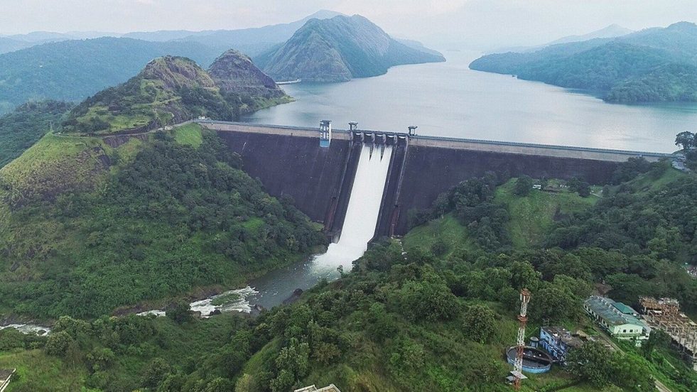
(Feature Image: Idukki dam in Kerala. Credit: Reju Arnold/ Source: The Week)
The two important developments over the past week have once again highlighted the worrying state of dam safety affairs in India. Firstly, the information shared by Union Jal Shakti Minister on Aug. 03, 2026 in Parliament has revealed that the National Dam Safety Authority (NDSA) has updated Emergency Action Plans (EAPs) for only 735 of the country’s 6,598 completed and operational specified dams as of July 30, 2026.
The state-wise data has further shown the wide disparities among the states. Maharashtra, which has the highest number of specified dams (2,713), has EAPs for only 65 dams. Madhya Pradesh has prepared EAPs for just 33 of its 1,370 specified dams. Rajasthan has completed 164 EAPs for its 313 specified dams. This shows the slow pace of safety preparedness concerning large dams in the country.
At the same time, the attempt to rush through the implementation of the Comprehensive Dam Safety Evaluation (CDSE) mandated under the Dam Safety Act, 2021 has also raised alarm bells. Dr. Brijendra Kumar Mishra, an Empaneled Expert with the NDSA, has expressed serious apprehensions over the apparent rush to complete CDSEs before the December 2026 deadline.
According to Dr. Mishra, a scientifically credible CDSE normally requires three to five months. It involves multiple field visits and detailed investigations. These include evaluation of structural safety, spillway capacity, gate operations, sedimentation, geological and seismic conditions, hydro-mechanical systems, and climate and disaster risks. Completing such evaluations within a few weeks raises serious questions about the credibility and quality of the reports.
Dr. Mishra has rightly argued that the compliance timeline should be realistic and adequate funding must also be extended beyond DRIP-supported dams. Most importantly, CDSEs should not become a mere compliance exercise at the cost of scientific rigor.
Indeed, both these issues have exposed concerning gaps in India’s dam safety framework and need urgent attention. With climate change increasing the frequency of extreme rainfall and floods, India needs a stronger, more transparent and accountable dam safety regime before the next disaster strikes.
DAM SAFETY
Emergency Action Plans updated for 735 of 6598 operational specified dams The National Dam Safety Authority (NDSA) has prepared and updated emergency action plans (EAPs) for 735 of the country’s 6,598 completed and operational specified dams as on July 30, the Rajya Sabha was informed by Union Jal Shakti Minister CR Patil on Aug 3 2026. The state and Union Territory-wise status tabled by the minister showed that Maharashtra has 2,713 specified dams, of which 65 have EAPs, followed by Madhya Pradesh with 1,370 specified dams and 33 EAPs, Gujarat with 524 dams and 39 EAPs, Chhattisgarh with 317 dams and four EAPs, and Rajasthan with 313 dams and 164 EAPs. Assam has prepared EAPs for all its three specified dams, while Nagaland and Tripura have updated EAPs for their lone specified dam each.
Rush to complete CDSE raises serious questions The Government of India’s Dam Safety Act, 2021, raised the bar for mandatory compliance, but implementation has struggled to keep pace. Dam owners are now being pushed to complete Comprehensive Dam Safety Evaluations within a short window ending in December 2026 — without adequate mass-awareness or capacity-building programmes to reach every dam operator.
A Comprehensive Dam Safety Evaluation (CDSE) is a critical exercise that requires a minimum of three to five months, involving multiple field visits and rigorous scientific investigation. This last-minute rush to complete CDSEs raises serious questions about the validation and authenticity of reports generated within just weeks or months — without adequately studying structural vulnerability, gate operations, spillway capacity, sedimentation, geological and seismic risk, climate and disaster risk, and other hydro-mechanical aspects of dam operation.
This is a wake-up call. The compliance timeline needs to be realistic rather than symbolic, funding must reach the thousands of dams left outside DRIP’s coverage, and no CDSE report should be treated as credible unless it has had the time and resources a genuine scientific evaluation demands. The issue deserves urgent discussion among policy makers and the bodies concerned, at the highest level, before the next disaster forces the conversation instead. (By Dr Brijendra Kumar Mishra, an Empanelled Expert with National Dam Safety Authority)
HYDRO POWER PROJECTS
Despite severe impacts, NBWL clears MP Pump Storage Project hampering Tiger Corridor also involving Ken Betwa mitigation plans The Despite “taking note” of the reservations expressed by a Madhya Pradesh Forest Department officer and acknowledging its location in an area used by tigers and other wildlife, the Standing Committee of the National Board for Wildlife (SC-NBWL) recently recommended clearance for the 1800 MW Panari pumped storage hydropower project in the Panna-Ranipur tiger corridor.

The project requires 411.48 ha forest land in key tiger corridor and the satellite core areas of Panna Tiger Reserve. The corridor in question connects forests around the Panna reserve across Satna and Panna districts to the Ranipur Tiger Reserve in Chitrakoot, UP. Prior to the project’s clearance in the SC-NBWL’s July 9, 2026, meeting, the panel had ordered a site inspection in January to ascertain its impact.
The corridor in question connects forests around the Panna reserve across Satna and Panna districts to the Ranipur Tiger Reserve in Chitrakoot, UP. A four-member team comprising officials from the Environment Ministry and National Tiger Conservation Authority (NTCA), a scientist from the Wildlife Institute of India (WII), and a DFO from Madhya Pradesh visited the site and recommended clearance, but with certain riders.
However, the DFO also underlined that the project is situated in an area that sees continuous, unhindered movement of tigers, leopards and bears. The DFO also highlighted that the proposed project is likely to block the corridor. Further, the DFO stated that due to the implementation of the Ken-Betwa river-linking project, wildlife activity and movement in this corridor had increased, and that there is no alternative pathway for wildlife dispersal.
However, clearance was recommended for the project with conditions to implement mitigation measures, the minutes of SC-NBWL’s July 9 meeting show. The key condition includes, among others, the construction of three 30-metre-wide wildlife overpasses across the Baghain River, which is frequently used by wildlife. While recommending clearance for the project, the standing committee did note the “reservations expressed by the field officers regarding possible fragmentation of the corridor”.
Himachal Minister Hydro firm to release promised funds and employment for local people Himachal Revenue minister Jagat Singh Negi has directed Goodwill Energy Enterprises Company to immediately release pending local area development authority (LADA) funds for its 29 MW hydropower project in Suru village, Koot gram panchayat of Rampur sub-division in Shimla district. During a meeting with company representatives Aug 7 2026 he also raised concerns over the company’s failure to provide employment to project-affected villagers as per the agreement, despite eight years having passed.
The minister instructed the company to take urgent measures to address seepage issues in the project tunnel, following recommendations by a high-level expert committee. He also directed repairs of the damaged Kutdu–Suru road to ensure safe travel for locals, especially during the monsoon season.
Parliamentary Panel concerned by Cost and time over runs at Hydro Projects A Parliamentary panel is concerned about shortfall in appointment of independent and women independent directors on NHPC Board. It is also concerned about cost & time over runs and climate risks in execution of hydro projects. It has recommended tighter monitoring of hydro projects, including by a committee of secretaries when cost or time over runs exceed 20%. It has recommended comprehensive climate risk assessment framework for all under construction and operating hydro projects. It has recommended extension of early warning systems for all NHPC subsidiaries and Joint Venture projects and providing the technologies for other PSUs.
DAMS
Telangana CM seeks higher Tummidahatti barrage, clearances Telangana Chief Minister A. Revanth Reddy made a strong pitch to the Central Government to convince the Mah Govt to allow increase in the height of Tummidihatti barrage on Pranahita river. The Chief Minister called on Union Jal Shakti Minister C.R. Patil in New Delhi on Aug 5, 2026 and referred to the letter addressed by the State to Prime Minister — who forwarded it to MoJS.
Mr. Revanth Reddy reminded that Telangana and Maharashtra reached an agreement over construction of barrage at Tummidihatti at 148 metres. Studies conducted by Pune based Central Water and Power Research Centre revealed that there would not be problems relating to submergence even if the height was increased to 152 metres as over 50% of the submergence would be confined to the riverbed.
Limiting the barrage height to 148 metres would not help release water in sufficient quantities and hence, the Centre should take the initiative of convincing Maharashtra government for allowing enhancement of barrage height to 150-152 metres. Ensuring flow of water through gravity would save the costs involved in pumping it using electricity. Explaining that completion of the project would ensure water supply to the backward Adilabad district, the Chief Minister requested the Union Minister to arrange a meeting between the two States to resolve the issue.
Mr. Patil acknowledged the receipt of letter from the Prime Minister’s Office and said a meeting of the Central Water Commission would be convened soon on the issue. This would be followed by the exercise on conducting an official level meeting between Telangana and Maharashtra governments. A meeting between the Irrigation Ministers of the two States would follow subsequently.
Sardar Sarovar: Panel asks for independent review of the project An independent three-member body headed by former Patna high court Justice Anjana Prakash and comprising of Sociologiest Enakshi Ganguly and Environmentalist Gorky Chakraborty has ‘reappraised’ the project and released its findings.
Identifying gaps in rehabilitation, unfulfilled promises and a clutch of emerging issues surrounding the Sardar Sarovar Project over the Narmada River, the panel has recommended various ameliorative measures, including a frank review of the project itself.
Ministry of Tribal Affairs in Rajya Sabha about Ken Betwa Project The PIB Press Release on the statement of Union Minister of State for Tribal Affairs Shri Durgadas Uikey in Rajya Sabha on Aug 5, 2026 provides no updated status, numbers or their settlement of Forest Rights.
Some excerpts: “Ministry of Tribal Affairs (MoTA) is member of Steering and Monitoring committees of Ken-Betwa Link Project, which inter alia monitors the progress of implementation of Action plan of R&R of Project Affected Families (PAFs). Further, MoTA had given a clearance for R&R plan for Scheduled Tribes Project Affected Families (ST-PAF) of Ken-Betwa Link Project, Phase –I, wherein the proposal provided by the National Water Development Agency, (NWDA) in 2016, mentioned that the Ken-Betwa Link Project, Phase-I involves displacement of a total of 1,913 Project Affected Families (PAFs) (population 8,339) out of which a total of 648 PAFs belong to Scheduled Tribes (ST)… However, Ministry of Tribal Affairs has received the various representations raising issues of displacement due to the Ken-Betwa River Link Project, which were examined and as the implementation of the FRA lies with the State Governments and UT Administration, these have been forwarded to the State Government of Madhya Pradesh and respective District Administrations for examination and necessary action. As implementation of Scheduled Tribes and Other Traditional Forest Dwellers (Recognition of Forest Rights) Act, 2006 (in short, FRA) lies with State Governments and UT Administrations, this data is not centrally maintained by MoTA.”
1. Nivakane (Integrated) Pumped Storage Project (2700 MW) in 361.82ha at Village Marathwadi, Tehsil Patan, Dist Satara, Mah by Adani Green Energy Ltd- Env Clearance: APPROVED
2. Ranavadi Pumped Storage Project (1200MW) in Pune & Raigad dists of Mah by Novarion Energy Pvt Ltd – Terms of Reference: Approved
3. Arakot Tiuni Hydroelectric Project (81MW) in Dist Uttarkashi, Uttarakhand by UJVNL – Terms of Reference: Approved
4. Deliberations on Cumulative Environmental Impact Assessment (CEIA) study reports of the Gori Ganga and Dhauliganga river basins: More info sought
5. Humbarli Birmani Open Loop Pumped Storage Project (1500 MW) in 334.82 ha at Biramani, and Hatlot, Sub-Dist Khed & Mahabaleshwar, Dist Ratnagiri & Satara, Mah by THDC India Ltd – Terms of Reference: APPROVED
6. Deliberation on the Site Visit Reports of Two (Malshej Ghat Borande Pumped Storage Project in Pune and Thane Dists, Mah, proposed by THDC; and ii. Amba Open Loop Pumped Storage Project (1500 MW) in Pune and Raigad Dists, Mah, proposed by NTPC Ltd.) Pumped Storage Projects in the Western Ghats: Approved
1. Attunli Hydroelectric Project (680 MW) Dibang Valley District, Arunachal Pradesh – Environmental Clearance
2. Patalkot Pumped Storage Project for 1500 MW (6 x 250MW) Patalkot Off-stream Closed Loop Pumped Storage Project near Patalkot village in Tamia taluka of Chhindwara district, Madhya Pradesh – Terms of References
3. Formation of Reservoir across Vallimalai Odai, Tamil Nadu – Terms of Reference
4. 93 MW New Ganderbal Hydro Electric Project to Gandervbal Dist of Jammu Kashmir by Jammu & Kashmir State Power Development Corp Ltd Validity extension of EC
INTERLINKING OF RIVERS
Ken-Betwa protest: Is there really surplus water to transfer? In this episode, Himanshu Thakkar of SANDRP breaks down the various ways in which the Ken-Betwa river link project doesn’t make sense and the underhanded reasons that it does, in chat with Devyanshi Bihani.
The interview unpacks whether the idea of a “surplus” river is scientifically sound, explores the communities that stand to be affected, the links between environmental impacts and rehabilitation, the role of forests and river ecosystems in maintaining water security and whether alternatives such as watershed development, rainwater harvesting and groundwater recharge could offer more sustainable solutions for Bundelkhand.
Finally, we examine what the Ken-Betwa project could mean for the future of India’s wider river-linking program, with 30 such projects proposed under the National Perspective Plan.
Ken-Betwa Link: Inside India’s controversial water megaproject India’s flagship ₹44,605-crore Ken-Betwa River Link has moved from blueprint to bulldozer, advancing construction at the Daudhan dam inside the Panna Tiger Reserve. As construction advances on India’s first river interlinking project, questions over water surplus, tiger habitat loss and tribal displacement remain unresolved even as the dam rises.
Himanshu Thakkar of the South Asia Network on Dams, Rivers and People (SANDRP) has stated plainly that “there is no surplus water in the Ken Basin.” He has also pointed to a claim with real bearing on how the project should be understood: that the project’s own Detailed Project Report reportedly admits its primary objective is not to serve drought-hit Bundelkhand villages but to transfer water to the upper Betwa basin districts of Raisen and Vidisha, which lie outside the Bundelkhand region entirely. If accurate, this represents a significant gap between the project’s public justification and its documented purpose.
SANDRP has pointed out that the project’s Stage II Forest Clearance was granted subject to conditions that would materially alter the project’s basic parameters, conditions that critics argue should trigger a fresh Environmental Impact Assessment and fresh clearances altogether, rather than being treated as a formality.
What is up with the Ken Betwa River Linking Project?
INTERSTATE WATER DISPUTES
Karnataka failed to utilize its share of 5,561 tmcft of water last decade through Upper Krishna project Krishna Water Disputes Tribunal in 2010 had awarded Karnataka to utilize 177 tmcft of annual water for agriculture and drinking water projects. However, due to non-implementation of the third phase of the Upper Krishna project (UKP), the State is unable to utilize its full share. It is estimated that in the last 10 years the State has released additional 5,561 tmcft of water downstream to the erstwhile undivided Andhra Pradesh. It is estimated that the Telugu speaking states are receiving additional 300 tmcft to 650 tmcft of water every year. Had the third phase of the project been implemented, irrigation facilities could have been provided to 5.94 lakh hectares in parts of the Kalyana Karnataka and Kittur Karnataka regions.
URBAN RIVERS
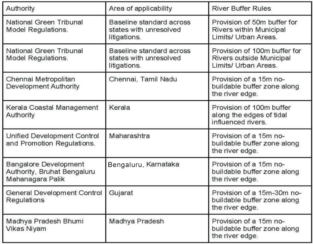
Plan not for River fronts, Plan for Natural Edges of Rivers & Ecology (By Resham Mehta and Rama Raghavan)
How Chennai can and must rebuild its relationship with water In Chennai, where water scarcity alternates with floods, the built-up area tripled from 102 to 295 square kilometres between 1991 and 2021 while water bodies declined by 55 percent. Wetlands which covered about 80 percent of the city’s area in 1980 had reduced to 15 percent in 2010. The way the city has been built – hard infrastructure encroaching on water bodies – denies it the ability to safely move its waters across the landscape during the monsoon, and to store and use during the drier months. The challenge is institutional as much as ecological. Forming a city-level ‘water council’ with the six agencies responsible for the city’s water; creating governance that promotes public participation and accountability; and under-preparation Chennai Master Plan 2046 are ways forward. (By Anirudh Kishore and Sahil Mathew)
RIVERS
How Communities Reclaimed Kashmir’s Doodh Ganga Along the banks of Kashmir’s Doodh Ganga River, residents patrol, run social media campaigns, and organise community cleanups to reclaim river common land. Their grassroots activism is not only bringing the river back to life, but also reviving the social fabric that was lost with the dying river.
Volunteers remove over 2 tonnes of waste from Yagamso river The drive was jointly organised by the Youth Mission for Clean River (YMCR) and the Abralow Memorial Multipurpose Society (AMMS) on Aug. 02, with support from the Itanagar Smart City Development Corporation Ltd (ISCDCL). Following the removal of debris, volunteers conducted a comprehensive waste audit to determine the primary causes and sources of pollution affecting the river body. The audit revealed a predominance of single-use plastics, packaging materials, construction debris, old clothing, and household waste.
The organisers on Aug. 03, said the diverse array of waste highlights a combination of unchecked littering and improper domestic waste disposal in the area. Highlighting the significance of the exercise, YMCR vice chairman Keyom Doni said the waste audit was critical to understanding the specific pollutants impacting the river system.
SC sets up Coordination Grp for Rajasthan’s Polluted Rivers: Jojari, Luni, Bandi The Supreme Court on Aug 7 2026 constituted an Integrated Coordination Group and a River Restoration Body to address pollution in the Jojari, Luni and Bandi rivers, and directed that a comprehensive river restoration plan be placed before it on September 22. The directions came in the suo motu proceedings titled In Re: 2 Million Lives at Risk, Contamination in Jojari River, Rajasthan, being heard by a Bench of Justices Vikram Nath & Sandeep Mehta.
Pronouncing the order, Justice Mehta said the newly constituted bodies would coordinate restoration efforts and prepare a comprehensive roadmap for cleaning the polluted rivers. “We have constituted an Integrated Coordination Group and a River Restoration Body to tackle pollution in the Jojari, Luni and Bandi rivers. Detailed directions will form part of the order and be shared with the State as well as the IPART Committee. The matter will now be taken up on September 22 to consider a comprehensive river restoration plan,” the Bench observed.
The Bench further fixed September 22 as the next date of hearing, when it will consider a comprehensive river restoration action plan aimed at addressing industrial pollution, restoring river ecology and ensuring long-term environmental protection in the affected regions.
Yamuna rises after season’s highest Hathnikund release According to Central Water Commission (CWC) data, the Yamuna began rising on Aug. 05, with the water level at the Old Railway Bridge increasing by 1.12m — from 202.38m at 1am to 203.50m at 8pm. According to the CWC forecast issued on Wednesday morning, the water level is likely to rise by around 1.5m over the next two days.
Bhim Singh Rawat, SANDRP, said the water level is currently about one metre below the warning level. “Data from upstream shows the water level has stabilised near Baghpat while it is still rising near Palla. The river is likely to rise further over the next 24 hours and may breach the warning level for the first time this season,” Rawat said. Rawat said water released from Hathnikund typically takes 48-72 hours to reach Delhi during the first flood spell after a prolonged dry summer, but once the river channel is saturated, the travel time reduces. “Around 38,000 cusecs of water was released around July 10, which caused the level to rise. This time, the water has reached Delhi faster,” he said.
RIVERS BIODIVERSITY
Assam To Push Centre For Shrinking Kaziranga ESZ From 10km to 1 km Announcing this CM Himanta Biswa Sarma said that the current 10-km buffer – in force because the park has not yet received its final ESZ notification – has restricted infrastructure and urban development in the area. In the absence of a final or even draft proposal from the state to the Centre, the Supreme Court’s default 10-km direction continues to apply. The Gauhati High Court observed this position as recently as March this year. The government’s push is expected to reopen debates over balancing conservation and development in the Kaziranga landscape. In June 2025, Assam withdrew the preliminary notification for a proposed ninth addition to the park covering 2,570 hectares in Sonitpur district, a decision that drew criticism from conservationists concerned about ecological connectivity.
FISH, FISHERIES, FISHERFOLKS
W Bengal’s state animal, Fishing Cat, threatened Member of Parliament Shomik Bhattacharya has urged the Indian government to formulate a comprehensive National Action Plan for the conservation of the Fishing Cat, the official state animal of West Bengal, warning that the species is increasingly threatened by habitat destruction, infrastructure expansion and human-wildlife conflict. Raising the issue during proceedings of the Rajya Sabha on August 7, Bhattacharya highlighted the declining population of the species. The species depends heavily on wetlands, marshlands and riverine ecosystems, but these habitats are rapidly disappearing due to encroachment, unplanned urban expansion, pollution and aquaculture development.
Hilsa spotted in Ganga near Ghazipur-UP, Farakka barrage cut off migration route Scientists spotted two hilsa in the Ganga along Ghazipur town in Uttar Pradesh earlier this week, decades after they were believed to have disappeared from the upper and middle stretches of the river, a sighting that scientists said may be an indication that the waters were once again conducive for the species.
Himanshu Thakkar of SANDRP said a more positive indicator would be if the fish were to breed and complete a life cycle or two. “At present, other evidence – including water quality parameters through government data related to the river shows the water’s increasingly deteriorating situation,” he said. Neeta Sehgal, Sr Professor (Fish biology) at the zoology department at Delhi University, said, “Two do not prove population recovery. True restoration would require evidence of natural migration, spawning, survival and successful reproduction” she said.
Invasive fish species spawns India’s first fishermen-driven removal system The Ujani reservoir, once famous for its high-quality freshwater fish, is now battling an ecological crisis triggered by invasive alien species – the suckermouth catfish, Tilapia, and African catfish. These foreign fish have decimated native biodiversity, collapsed local fish populations and put the livelihoods of thousands of fishermen at risk. In response, the Bombay Natural History Society (BNHS) has launched an active removal and native-restocking programme, marking India’s first such community-driven initiative.
Microplastics in Yamuna fish pose health risks Microplastics accumulating in freshwater fish from the Yamuna could pose long-term health risks ranging from neuro-inflammation and cognitive impairment to cellular damage, doctors said, after a recent study reported widespread contamination in fish from the river.
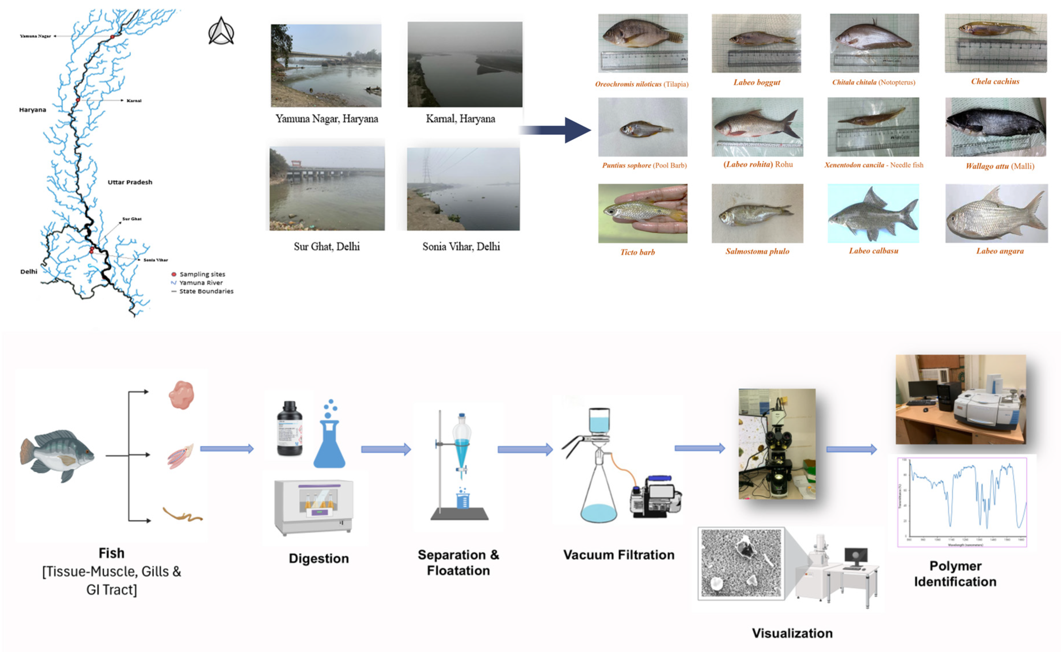
The researchers analysed 220 fish representing 12 freshwater species collected from four locations across Haryana and Delhi, and found 1,678 microplastic particles. They reported significantly higher microplastic accumulation in fish collected from the Delhi stretch of the Yamuna than at upstream locations, describing the work as a first-of-its-kind scientific investigation that provides baseline data on microplastic pollution, ecological risks and potential food safety concerns in Indian freshwater ecosystems.
SAND MINING
3,000 dredging passes go missing In a major security breach at the Mumbai Collectorate, 3,000 blank government royalty receipts used to issue mineral transport permits have allegedly been stolen from a locked godown inside the Old Custom House building in Fort. The theft has raised concerns that illegal sand-mining syndicates could get their hands on the receipts to create forged transport permits, allowing illegally excavated minerals to be transported as legitimate consignments by evading enforcement checks.
The theft was discovered on July 13 when officials opened the godown to issue permit books and found that one box was missing. A stock audit later revealed that receipt books bearing serial numbers 25561 to 25620 had been stolen. Each book contained 50 blank receipts.
Although the paper value of the missing receipts is estimated at only Rs 5,400, officials fear their misuse could lead to substantial revenue losses and aid organised illegal mining operations. Once filled in, the receipts can be used to generate apparently genuine permits for trucks transporting sand, stone, gravel and other minor minerals.
Illegal sand mining weakening river embankments? Illegal sand mining from riverbeds across Odisha is emerging as a major environmental concern, with experts warning that unchecked extraction is weakening river embankments and increasing the risk of devastating floods. Rivers such as the Brahmani, Baitarani, Subarnarekha and Mahanadi etc have witnessed extensive sand mining, with heavy machinery being used to excavate riverbeds and banks on a large scale.
Experts further argue that indiscriminate mining disturbs the natural balance of rivers by altering their depth, sediment composition and water flow. The loss of sand, which naturally regulates the speed and direction of flowing water, can intensify currents and increase erosion. In some cases, altered river channels may divert floodwaters towards populated areas and farmlands.
Odisha govt fixes sand MSP at Rs 340 The minimum support price (MSP) of sand has been fixed at Rs 340. Reports suggested that sand cannot be sold at a price higher than the prescribed MSP. The government is also set to auction sand quarries to regulate excavation and transportation. In the first phase, more than 100 sand quarries are expected to be auctioned through e-lottery soon.
Notice for sand transit permits during flood The Jagatsinghpur district administration has issued a show-cause notice to the district mining officer (DMO) over the alleged issuance of transit permits (TPs) for sand extraction during the recent flood even as a district-wide ban on mining was in force for public safety and flood management.
Collector J Sonal issued the notice to the officer on Aug. 06, seeking an explanation within two days on why disciplinary and administrative action should not be initiated for the alleged acts of omission and commission. The collector stated that if the allegations are found to be true, the issue of permits during the ban would amount to a violation of the instructions issued by the state government, besides adversely affecting flood management measures undertaken to protect lives and property in flood-prone areas.
The state Mining Department on Aug. 04 launched a joint crackdown on the alleged illegal transportation of sand from Odisha’s Balasore district to West Bengal. The department seized four Hyva trucks and two tractors during raids in Jaleswar, Basta and Baliapal. The action came amid allegations that ‘sand is being transported illegally across the state border every day despite repeated complaints by local residents’.
Brick kilns along Ithikkara river in Kerala There is no adequate sand available for mining in the Ithikkara river in Kollam, the NGT was told on July 29, 2026. The District Collector’s report said a sand audit found no adequate sand availability for mining in the river. It also said the Revenue Department had issued a government order on May 30, 2023, banning sand mining in the Ithikkara river for three years.
The report informed the tribunal that the Local Self Government Department had been directed to inspect brick kilns operating along the riverbanks and take appropriate action to shut down illegal operations. Notices were accordingly issued to brick kiln operators.
NGT shuts stone mine over illegal access road in Aravali The NGT has ordered the closure of a stone mining operation in Haryana’s Mahendergarh district after finding that the leaseholder accessed the mine through an unauthorised road passing through Aravali Plantation without mandatory forest clearance. The tribunal also held that the company violated multiple conditions of its environmental clearance (EC).
Quarrying near Irumankulam waterbody The NGT’s southern bench on July 28, 2026, took up an application concerning quarrying activities that allegedly disrupted the natural drainage system and affected irrigation in Irumankulam village, Tenkasi district, Tamil Nadu.
The tribunal said the issues raised in the application had been adequately addressed by the directions of the Madras High Court and the consequent action taken by the District Collector and the Tamil Nadu Pollution Control Board. Since restoration of the Nilaviyal Odai and regulation of quarry operations were already being implemented under the High Court’s orders, no further interference by the tribunal was necessary, the order said.
WETLANDS, LAKES, WATER BODIES
‘Verify, demarcate wetlands in SAC Atlas within 2 months’: SC A bench of justices Aravind Kumar and Vipul M Pancholi made it clear that the statutory exercise of “ground-truthing” and boundary demarcation under the Wetlands (Conservation and Management) Rules, 2017, cannot be completed merely on paper and must involve physical identification of the wetlands on the ground.
“Ground truthing and demarcation of wetland boundary should not only be on paper but also to be physically carried out and identification of such wetlands or water bodies as identified by the SAC Atlas shall be undertaken by all the states if not already undertaken and a report be filed before this court expeditiously and at any rate within an outer limit of two months,” the bench directed in an order passed on July 28.
The court added: “This exercise of physical verification if not undertaken, the Secretaries of Ministry of Environment and Forest and the Vice Chairman of the respective State Wetland Authorities shall appear in person on the next date of hearing and show cause as to why further steps should not be taken by this court for non-compliance,” adding that any breach of its present or previous directions would be viewed “very seriously”.
The latest order marks a significant escalation in litigation the top court has been monitoring since 2018 to ensure the identification, notification and protection of wetlands across the country. The proceedings arise from a batch of public interest litigations filed by Greater Noida-based birder and environmentalist Anand Arya, advocate MK Balakrishnan and NGO Vanashakti.
Accepting the submission, the bench observed that despite its repeated orders, some states and their wetland authorities were attempting to take a position contrary to the court’s directions. “When our order dated 11.12.2024 which has been reiterated on 19.08.2025, 07.10.2025 and 28.10.2025 is clear, we fail to understand as to how the states or its instrumentalities or the Wetland Authorities…can take a different view,” the bench said before directing that both ground-truthing and demarcation should not only be on paper but also be physically carried out.
The direction effectively gives all states and UTs a final two-month window to complete physical verification of every wetland or water body mapped in the SAC Atlas and place compliance reports before the court.
The litigation concerns wetlands identified by the Space Applications Centre under ISRO’s Wetland Atlas. Earlier proceedings revealed that the number of wetlands larger than 2.25 hectares had risen from 201,503 in earlier inventories to 231,195 in the 2021 SAC Atlas, making physical verification essential before legal protection could be extended.
10 km radius buffer for mining extends to all wetland reserves: SC The Supreme Court orally clarified on Aug 4, 2026 that a direction banning mining activities within a 10 km radius of the Asan wetland conservation reserve, a Ramsar site in Uttarakhand, would apply to other wetland conservation reserves across the country for the sake of parity. “Wherever it is a community or a wetland conservation reserve, Asan [directions] will be applied. Wetlands are in a different category…” Justice Joymalya Bagchi, part of the Bench headed by Chief Justice of India Surya Kant, observed. The court was hearing an application filed by Himachal Pradesh arguing that the 10 km radius restriction imposed in Uttarakhand should not apply to it.
Himachal Pradesh said the Asan reserve did not come within its territory. Its counsel said there was no need for a buffer zone outside the reserve area, unlike in the case of national parks and sanctuaries. The trigger for the Himachal Pradesh plea was a pending petition in the State High Court arguing that since Uttarakhand and Himachal Pradesh were adjoining States, the February 14, 2014 direction of the apex court would extend to the latter also.
Chief Justice Kant said there was no argument on the fact that the Himalayan terrain passed through both the adjoining States. The apex court, however, said whether the Asan reserve was located in Himachal Pradesh or not was a question of fact. The Bench directed the standing committee of the National Board of Wildlife or the Ministry of Environment, Forests and Climate Change to determine the fact. The top court underscored that if the wetland conservation reserve was found to be in Himachal Pradesh, the February 14, 2024, ban on mining in Uttarakhand would extend to Himachal Pradesh too.
If, on the other hand, the reserve is not found to be in the Himachal Pradesh territory, the decision on whether or not to allow mining would be taken by the competent authority in accordance with the law. “The entire Himalayan terrain has to be governed by the same set of directions. The only exception can be if an expert committee says the wetland reserve is not in your State,” the CJI addressed Himachal Pradesh.
On February 14, 2024, the apex court passed an interim order that “no mining activities would be carried out within 10 km radius of the Asan wetland conservation reserve without the project proponent obtaining permission from the Standing Committee of the National Board of Wildlife and/or MoEF&CC. “The additional reason that weighs with us in issuing this direction is due to the importance given to the wetland, which was declared to be Ramsar site under the Ramsar Convention”, said SC.
The high court of Uttrakhand in its order of July 2, 2015 held that mining around Asan wetland conservation reserve will be permitted only if the mining activity is located beyond 10 kilometres from the wetland site. This order of the HC was initially challenged by the Uttarakhand government , but the state withdrew the appeal to file a review against the HC order. The HC dismissed the review plea against which the state did not file an appeal making it final and binding against the state.
Considering these facts, the top court in its February 2024 order said, “By way of interim order we direct that no mining activities would be carried out within 10 kms. radius of the Asan Wetland Conservation Reserve without the project proponent obtaining permission from the Standing Committee of the National Board of Wildlife and/or MoEFCC.”
The court held that one of the primary reasons for passing such an order was to preserve the wetland, declared as a Ramsar site under the Ramsar Convention. Later in October 2024, the court clarified that its order shall not be seen as laying down universal guidelines for all conservation reserves and community reserves. As the Centre had already framed guidelines to be followed by the state governments on the restrictions to be imposed on a case to case basis, the court refused to pass any general order in this regard.
Pond used for bridge construction in Chengalpattu The NGT on July 29, 2026, directed the District Collector, Chengalpattu, and the NHAI to file their respective reports, along with relevant documents, on the alleged obliteration of a pond for bridge construction. The respondents have claimed that they had approval from the Tamil Nadu government as well as the Union government.
The applicant, Mallai Water Bodies Protection and Preservation Association, Mahabalipuram, was also directed to furnish the relevant page of the wetland atlas concerning Solaipoigai, which it said is a notified wetland under the Wetlands (Conservation and Management) Rules, 2017. The matter relates to a portion of a waterbody being used by the NHAI for the construction of a bridge.
Reports filed by the District Collector, Chengalpattu, and the NHAI admitted that 3,460 square metres of the pond, out of its total area of 15,000 square metres, had been obliterated. The reports stated that the edge of the Solaipoigai tank was affected because it was necessary to improve the geometric design of the highway between the at-grade junction and the major bridge to ensure the safety of road users. As compensation, four nearby tanks were desilted under the Amrit Sarovar scheme, the reports said.
RAMSAR WETLANDS
Glaw Lake becomes Arunachal Pradesh’s First Ramsar Site Located within the Kamlang Tiger Reserve and Wildlife Sanctuary, Glaw Lake is a pristine freshwater lake in the Eastern Himalayas and a biodiversity hotspot. The lake is fed by perennial mountain streams and is surrounded by lush vegetation, supporting rich floral diversity. The Minister informed that the wetland has over 150 tree species and 49 orchid species recorded within the site and its catchment, underscoring the ecological significance of Glaw Lake and its surrounding landscape.
CPCB Finds Manasbal Water Unfit Even For Bathing Water samples collected from Manasbal Lake and its feeder system by the Central Pollution Control Board (CPCB) have revealed widespread contamination, with none of the seven tested locations meeting the prescribed Class B standard for outdoor bathing. The findings have raised serious concerns over the quality of water supplied for drinking purposes to thousands of residents in parts of Ganderbal and Bandipora districts.
The CPCB conducted the sampling on April 4, 2026, following directions from the NGT in a case filed by environmental activist Dr Raja Muzaffar Bhat, who had alleged that untreated sewage from 14 villages was entering the Manasbal wetland through the Lar Canal. The NGT had ordered the CPCB and JKPCC on January 30, 2026, to ascertain the water quality of the wetland, identify sources of pollutant discharge and submit a status and action-taken report.
The petition before the Tribunal alleges that untreated sewage from 14 villages is entering Manasbal Wetland through the Lar Canal, causing severe ecological degradation. Bhat has also submitted that the lake is a drinking-water source for thousands of people in Safapora, Sumbal, Sonawari and adjoining areas of Ganderbal and Bandipora districts. The NGT is now expected to consider the CPCB findings along with the responses and action-taken reports of the concerned authorities before passing its final order in the matter.
Plans for integrated development of Chilika & Satapada A high-level review meeting chaired by deputy chief minister Pravati Parida and law, works and excise minister Prithiviraj Harichandan discussed the proposal on Aug. 04. The meeting focuses on developing Asia’s largest brackish water lagoon and Ramsar site into an internationally acclaimed tourism hub by strengthening infrastructure, enhancing visitor amenities and promoting sustainable tourism.
Parida stressed the need to improve tourism infrastructure in and around Chilika and develop world-class hospitality facilities without compromising on the lake’s ecological balance. Officials said various agencies presented conceptual master plans during the meeting. The proposals include construction of improved road networks, modern jetties, parking facilities, bird-viewing points, cycling tracks, roller skating zones, water sports and boating facilities, trekking routes, tree houses, open food courts, picnic areas and installation of public art reflecting Odisha’s cultural heritage.
WATER OPTIONS
Monsoon revives dry Aravali slopes with streams, check-dam overflow Water is now flowing through the valleys, spilling over rocky outcrops and turning seasonal streams into temporary waterfalls, from Ghamroj, Gairatpur Bas, Khod Basai and Kotla to stretches of the range near Faridabad. In the space of a few heavy showers, waterfalls have appeared on slopes that were bone dry a fortnight ago. Check dams built by the forest department are full to the brim and spilling over, and rocky depressions that sat empty through April, May and June are now quiet pools ringed by startlingly green vegetation.
At Khod Basai, a check dam built by the forest department this March has filled to capacity. Water is spilling over the edge in a steady sheet, following the natural slope of the terrain towards the KMP corridor. The check dams at Gairatpur Bas and Khod Basai were both built this March, ahead of the monsoon, as part of that effort. The logic is straightforward: rain on rocky Aravali terrain moves fast, and without structures to interrupt it, the water rushes off the slopes and is gone. With them, it pauses, pools, and slowly works its way into the fractured rock below.
For a few weeks at least, the oldest mountain range in the subcontinent is reminding the cities at its edge that it is not just scenery. The rains will pass, and the waterfalls will go with them — but in the fractured rock beneath, in the slowly recharging aquifers and the thickening roots of new vegetation, something of this monsoon will stay behind.
GROUNDWATER
Nitrate contamination found in groundwater across 26 states, UTs Union Minister Anupriya Patel on Aug. 07 said 20.71 per cent of groundwater samples analysed in 502 districts across 26 states/UTs were found to contain nitrate above the permissible limit of 45 mg/L.Quoting the Annual Ground Water Quality Report-2025, she said the maximum number of affected districts (48) lie in Uttar Pradesh followed by 44 districts in Madhya Pradesh, 38 districts in Tamil Nadu and 33 districts each in Maharashtra and Telangana. While in Punjab, 21 districts have reported nitrate contamination in the groundwater, 22 districts in Haryana have reported the same. Himachal Pradesh and Jammu and Kashmir witnessed the problem in six of their districts each, she noted.
Gujarat’s ‘wave well’ draws experts to investigate A well in Gujarat’s Morbi district has become an unlikely attraction after its water began moving in steady, wave-like patterns without any obvious trigger. The unusual sight, captured on video in Virparda village, has gone viral, leaving residents and experts searching for an explanation. The ripples appear almost continuous, even though there is no visible object disturbing the water. Locals say the movement is sometimes so strong that water spills over the rim of the well.
The unusual movement of water in a farmer’s well in Virparda village of Morbi taluka has prompted the district administration to order a technical investigation. The well, located in the field of farmer Pranjivanbhai Saradia, was constructed around three months before the monsoon. Following good rainfall this season, it filled with water. Since Aug. 02, however, the water has repeatedly turned turbid and moved in wave-like patterns. While the movement subsided briefly on Tuesday, it resumed on Wednesday evening.
Acting on the collector’s instructions, District Geologist Jagdish Vadher visited the site for a preliminary assessment. According to him, the movement is likely being caused by pressure from trapped gas between rock layers as fresh rainwater seeps into the underground strata. Collector Khare said the administration also sought an immediate technical assessment from the State Seismology Department after concerns were raised among local residents. The department’s findings showed that no earthquake or underground seismic activity had been recorded in Morbi district over the past eight to ten days.
As the water continues to oscillate, the collector has directed experts from the Ground Water Research Institute (GWRI) to conduct a detailed site investigation. A special GWRI team will soon examine the groundwater and soil conditions at the site. The exact reason behind the unusual movement of the well water will be determined only after the team submits its final technical report, officials said.
URBAN LAKES, WETLANDS
The invisible threat of nutrient pollution Nutrient pollution has become one of the most overlooked environmental problems in Indian cities. Unlike industrial pollution, which is often immediately visible, nutrient pollution develops gradually and quietly. Domestic sewage, phosphate-rich detergents, food waste, untreated wastewater, fertiliser runoff, pet waste, and urban storm water continuously introduce excessive nitrogen and phosphorus into lakes. Over time, these nutrients accumulate and fundamentally alter aquatic ecosystems.
Initially, nutrients stimulate rapid growth of algae and aquatic plants. However, as dense algal blooms spread across the water surface, sunlight penetration declines, aquatic vegetation dies, and dissolved oxygen levels fall dramatically. Eventually, fish kills become common, unpleasant odours develop, biodiversity declines, and the lake gradually loses its ecological functions. The nutrient pollution as “silent pollution”, because its impacts become evident only after extensive ecological damage, has already occurred. Recent water quality investigations clearly demonstrate that Hauz Khas Lake is experiencing continuous nutrient enrichment resulting from anthropogenic activities. (Prabhat Kumar Tanwar, Sarita Bansal, N Raghuram)
Say no to PoP Ganesha idols, GBA to citizens With Ganesha Chaturthi around the corner, the GBA has given a call for eco-friendly celebrations. In a release from the GBA Forest, Environment and Ecology Department, the department said the production, sale, and disposal of Ganesha idols made of Plaster of Paris (PoP), chemical paints containing heavy metals, and artificial/non-biodegradable materials in water sources are prohibited within jurisdiction of GBA during Ganesha Chaturthi.
URBAN WATER
Stop memo issued to plywood factory in Thodupuzha in Kerala The Idukki District Collector has issued a stop memo to a plywood factory at Velliyamattom in Thodupuzha after chemical-laden water from the unit flowed into the Malankara Dam, polluting the reservoir. Local residents first noticed the chemical residue floating in the dam water on Aug. 07. Once alerted, Kerala Water Authority (KWA) officials suspended pumping operations for five drinking water schemes reliant on the reservoir.
Water crisis hits Vizag With inadequate rainfall and depletion of groundwater sources, a sudden water scarcity has hit Visakhapatnam city, leaving residents across several parts struggling to meet their daily water requirements. The crisis has particularly affected areas such as Arilova, Yendada, Madhurawada and Bheemunipatnam, where even drinking water supplies have come under strain.
INDUSTRIAL WATER USE
In Parliament: Govt on Water Use in AI Data Centres Artificial Intelligence (AI) Data Centres do not, per se, require Environmental Clearance (EC) under the Environmental Impact Assessment (EIA) Notification, 2006. However, AI Data Centres proposed as part of a “Building and Construction Project” under Item 8(a), i.e. built up area exceeding 20,000 sq. m or a “Township and Area Development Project” i.e. covering an area ≥ 50 ha and /or built up area ≥ 1,50,000 sq. m under Item 8(b) of the schedule to the EIA Notification, 2006 require prior EC. The EC for such a building project is granted by the State Environment Impact Assessment Authority (SEIAA) at the State/UT level.
During the appraisal of such building projects for grant of EC, various aspects such as availability of freshwater particularly in water-stressed regions, water balance report, generation of greywater, recycling and reuse of greywater are duly considered and appropriate environmental safeguards are prescribed. Further, the use and discharge of water and greywater during the construction and operation of AI Data Centres is regulated under the Water (Prevention and Control of Pollution) Act, 1974, and the Air (Prevention and Control of Pollution) Act, 1981. Compliance with the provisions of these Acts, including the prescribed standards for water use and wastewater discharge, is monitored by the concerned State Pollution Control Board (SPCB) or Pollution Control Committee (PCC), as applicable.
Further, groundwater extraction for infrastructure/commercial projects is regulated in accordance with the guidelines issued by the Ministry of Jal Shakti vide Notification S.O. 3289(E) dated 24.09.2020, as amended vide Notification dated 29.03.2023.
The Bureau of Energy Efficiency (BEE) has issued the District Cooling Guidelines, 2023, which, inter alia, recommend the use of treated water as cooling tower make-up water, wherever feasible, to reduce dependence on freshwater resources and promote sustainable water management. The Guidelines also emphasize the adoption of energy-efficient cooling technologies, optimization of cooling system performance, utilization of alternative water sources, and implementation of water conservation measures. These measures are particularly relevant for large cooling-intensive facilities, including data centres, and support enhanced energy efficiency, reduced water consumption, and sustainable operation of cooling infrastructure.
As per information provided by the Ministry of Electronics and Information Technology, the ‘Resilience, Innovation & Efficiency’ Working Group of the India AI Impact Summit has been set up to examine energy efficiency, water management, and environmental resilience in digital and AI infrastructure. This information was provided by MINISTER OF STATE IN THE MINISTRY OF ENVIRONMENT, FOREST AND CLIMATE CHANGE, SHRI KIRTI VARDHAN SINGH, in a written reply to a question in Rajya Sabha on Aug 6 2026.
AI data centres do not need environment clearance, Centre tells Parliament Artificial Intelligence data centres do not require a separate clearance under the 2006 Environmental Impact Assessment notification, the Union Ministry of Environment, Forests and Climate Change said in a written reply to the Parliament on Thursday. The Ministry said that data centre operations in India were governed under other existing laws, and that the Centre was ensuring that “appropriate environmental safeguards” were followed.
AGRICULTURE
Andhra farmers reluctant to move away from paddy despite climate risks: Study Even as erratic rainfall and climate change continue to threaten agriculture, most rice farmers in Andhra Pradesh remain reluctant to shift to alternative crops, preferring instead to improve traditional paddy cultivation practices, according to a recent study conducted across East Godavari, West Godavari, and Krishna districts.
For example, as of July, paddy sowing had covered 5.94 lakh hectares in the state, reaching 91% of the season’s normal despite El Niño conditions, according to statistics from the agricultural department. This reflects the continued dependence of many farmers on paddy cultivation, with few perceiving viable alternatives despite recurring climate-related challenges.
According to the study, ‘Factors Influencing the Adaptation Behaviour of Rice Growers to Climate Change in Andhra Pradesh’, nearly 70% of the respondents preferred traditional farming practices, while 65.83% admitted they lacked knowledge about alternative cropping systems. Off-farm diversification also found little acceptance, with 82.08% of farmers saying they had not adopted it as an adaptation strategy.
Rather than moving away from paddy, farmers are choosing to adapt within the existing production system. All the farmers surveyed reported adopting deep summer ploughing and cultivating high-yielding rice varieties, indicating a preference for improving productivity and resilience without changing crops.
MONSOON 2026
Recent rain has little impact on national monsoon deficit Good rains in the past one week over Delhi, Haryana and east Rajasthan helped offset the shortfall in these areas, but they did not reduce the overall country-wide monsoon deficit by much. In this period, India’s cumulative rainfall deficit was down by only one percentage point – from 12% on Aug 2 to 11% on Aug 9 – with many agrarian states, including Bihar, Jharkhand, UP, Punjab and Andhra Pradesh, continuing to witness deficient rainfall.
Delhi crosses August rainfall average in first 8 days The national capital has crossed its average monthly rainfall for August in just the first eight days of the month, with the Safdarjung Observatory recording 230.1 mm of rain so far. Safdarjung, the city’s prime observatory, had recorded 225.7 mm of rainfall between the start of the month and till 8.30 am on Aug. 01, while another 4.4 mm was recorded between 8.30 am and 5.30 pm, taking the cumulative rainfall to 230.1 mm.
Delhi on Aug. 08 recorded its wettest August day in two years, with the capital receiving 98.7 mm of rain till 8.30 am, while the month’s cumulative rainfall at Safdarjung reached 225.7 mm, nearly touching the monthly average of 233.1 mm. During the first 8 days of August, Safdarjung recorded 188.4 mm against a normal of around 60 mm, 214 per cent above normal. Palam received 155.4 mm against 57.9 mm, 168 per cent above normal, while Lodhi Road recorded 198.5 mm against 60 mm, 231 per cent above normal. The Ridge recorded 184.4 mm, 225 per cent above normal, while Aya Nagar received 239.3 mm, 455 per cent above normal.
FLOOD 2026
Unprecedented Assam floods in July According to offifcial data, exceptionally heavy rainfall in Nagaland triggered the disaster. Rainfall departures reached 181% above normal across the state during the critical period, with Mokokchung recording 493% above normal, Wokha 108%, and Mon 45%. Combined with intense local rainfall in Charaideo and Sivasagar in Assam, the result was catastrophic. Chief Minister Himanta Biswa Sarma later ruled out both dam releases and cloudbursts as the primary cause.
Water Resources Minister Pijush Hazarika said, “On July 19, massive water flow from Nagaland led to an unprecedented flood in Assam. Places like Nazira, Charaideo and Titabor had never witnessed such flooding before. We are always prepared for the state’s regular floods, but this was not a normal flood; it is a natural calamity.” In Nagaland’s Mon district, torrential rain fell for nearly 16 hours on July 19, triggering more than 60 landslides and displacing around 600 households in Naginimora and Tizit.
Eleven people died, including eight in a landslide in Mon town. Mon Deputy Commissioner Wennyei Konyak ruled out speculation that the Dikhow River had been blocked. He called for a joint Dikhow river basin management plan between Nagaland and Assam and greater public awareness to curb hill degradation.
The first indication came not from weather alerts but from a phone call by the Deputy Commissioner of Mokokchung requesting rescue boats, since villages on the Nagaland side were already underwater. The Jhanji River was rising rapidly. It was the result of multiple forces converging, including extraordinary rainfall, the state’s flood-prone geography, degraded upstream catchments, excessive siltation, loss of natural flood buffers, ageing embankments, gaps in forecasting and early warning systems. If July 19 exposed anything, it is that Assam’s flood crisis is no longer just about managing rivers. It is about managing an interconnected landscape that extends far beyond the state’s borders.
Coal, stone mining, injudicious urbanisation turned Assam’s floods into a disaster Experts argue that Assam bore the brunt of the current monsoon emergency not merely because of excessively high rainfall but also because of illegal coal mining in Nagaland along the border with Assam and unauthorised stone extraction in the Sivasagar district of Assam.
That the floods have reached areas such as Charaideo, Jorhat and Sivasagar – which are typically unaffected by monsoon-related floods – has come as a shock to outsiders, but not to those who have warned about “anthropogenic” reasons, meaning those caused by human activity. Dr Pranjal Protim Buragohain, Professor, Department of Economics, Dibrugarh University, Assam, tells Open that injudicious urbanisation in Nagaland and other illegal activities such as coal and stone mining have contributed hugely to this catastrophe. “As a result, the water sequestration capacity of the soil in the newly affected regions has drastically deteriorated,” he says. Water sequestration capacity refers to an ecosystem’s ability to retain, store and manage water resources. That capacity is closely linked to vegetation and soil composition.
Assam CM says Nagaland flood affected depend on illegal coal-sand mining Chief Minister Himanta Biswa Sarma on Aug 4 2026 claimed that most of the people affected in the Upper Assam flood depend on coal-sand mining in neighbouring Nagaland, and they must decide on closing the “illegal” ones. Sarma’s statement came following the opposition’s demand to shut all illegal coal-sand mining to prevent a recurrence of floods in Upper Assam districts.
After visiting some flood-hit areas, he also said that Assam cannot stop any mining taking place in Nagaland, and the central government will have to be involved in the process. In the latest wave of floods, widespread devastation occurred in Sivasagar and Charaideo districts, especially in the bordering areas of Assam-Nagaland, while at least 87 people died and nearly 1.3 lakh others were impacted.
“What we can do is shut down the stone crushers operating on the Assam side. If that helps in any way, we will definitely do it,” the CM added. While Sarma refrained from drawing conclusions on allegations linking mining in Nagaland to the floods, he called for an investigation based on satellite data and expert analysis by an institute like IIT Guwahati. “This is not something politicians can answer. It did not happen every year, so why did it happen this year? Satellite data and scientific analysis are needed to determine the reasons,” Sarma said. He added that Nagaland also needs to do similar study.
Assam can’t be a charity case every monsoon Assam’s floods are complex. The Brahmaputra is one of the world’s great rivers, and heavy monsoon rainfall has always shaped life here. But deforestation, unplanned development, changes in land use, and ecological degradation can make disasters more destructive. These realities demand serious scientific study and long-term planning.
What is most worrying is what repeated floods do to people’s willingness to build a life. Why invest in a garden if it may disappear next year? Why raise animals if they may be swept away? Why cultivate a field if you do not know whether you will harvest it? If flooding continues to reach places that were once considered safe, it could change where people live, what they grow, how they work, and how they imagine their future. (Rima Das)
DAM FLOOD 2026
Maharashtra: Dahanu faced devastating flood without warning Twenty three people died in Palghar district in July as rains damaged property and infrastructure valued at Rs 180 crore. The incessant rain had started on July 20 in South Gujarat and the areas bordering Palghar. Dahanu town, about 150 km from Mumbai, was paralysed. The Surya river was flowing much above its normal level but residents had not been warned that the gates of the Dhamni dam upstream were going to be opened to discharge water from its rapidly filling reservoir.
That happened on July 23. According to official information, the Dhamni dam was 94% full at 10 am and the spillway gates were increased by 50 cm, opening to 125 cm. As a result, 18,037 cusecs of water was discharged. The reservoir from the eathern Kawadas dam below Dhamni was also overflowing. It is a pickup weir and has no gates. It discharged a total of 59,599 cusecs of water. At 11 am, the gates of the Dhamni dam were opened further to 150 cm, discharging 30,671 cusecs. Together with the overflow from Kawadas, this amounted to a massive 116,235.75 cusecs.
According to official sources, the gram sevaks and talatis – village-level revenue officials – were sent Whatsapp messages telling them to inform villagers that a flood was likely. However, the collapse of the mobile phone networks meant the warning could not be passed on to the villages downstream of the Dhamni.
The flood Standard Operating Procedure for Dhamni dam had marked residents of 17 villages downstream to be shifted in case of heavy rain. But it is not clear whether that happened. The Palghar district collector had only issued instructions warning villagers to move to safer locations and be in touch with the gram panchayat for updates.
By the time district officials held a meeting about the flooding at 5.30 pm on July 23, the water had already started abating. As we realised, electricity was not available for five or six days as many trees and poles had fallen during the heavy rain. Even drinking water was not supplied in most places for several days.
Probe sought into Chattamakhana dam damage Balangir MLA Kalikesh Narayan Singh Deo has urged CM Mohan Charan Majhi to carry out an independent technical enquiry into the alleged structural damage to newly-constructed Chattamakhana Dam in Balangir district in the recent rains. In a letter to the CM, who also holds the Water Resources portfolio, Singh Deo stated that the damage to the dam included washing away of the cut-off wall and failure of the downstream embankments. They raised serious concerns over the safety and structural adequacy of the project.
Sambalpur: Check dam breaks, two breaches flood farmland A check dam broke following continuous rainfall at Solaghara in Sambalpur district. This created two breaches and inundated several hectares of agricultural land. Floodwater entered farmlands in the affected area, while sand deposits also spread across some agricultural fields. Local residents demanded a permanent solution to the damaged check dam, construction of a protective wall along the embankment and compensation for affected farmers.
HFL BREACH
July 2026: Rivers Crossing Highest Flood Levels In July 2026, SANDRP has documented Highest Flood Level (HFL) breaches at least at 15 flood monitoring sites of Central Water Commission (CWC) in India. These 15 sites are spread over 7 river basins, with maximum 4 sites in Brahmaputra basin followed by 3 sites each in Brahmani & Baitarani and Mahanadi basin, 2 sites in West Flowing Rivers from Tapi to Tadri basin and at 1 site each in Ganga, Narmada and Tapi river basin.
URBAN FLOODS
Flooding in Delhi during monsoon De-silting of 77 drains of the Irrigation and Flood Control Department (I&FC) Delhi has been carried out before the monsoon season 2026 and 3.105 million tonnes silt has been desilted from all the 77 drains. De-silting of all other drains falling under the jurisdiction of the Municipal Corporation of Delhi (MCD) and the Public Works Department (PWD) shall be carried out by them. This was stated in the report filed by the I&FC and taken up by the NGT, August 3, 2026.
The court was informed that for assessing long-term measures, the Central Water and Power Research Station (CWPRS), Pune, has been assigned the work of scientific assessment of River Yamuna by application of hybrid model. Further measures would be taken after receiving the CWPRS report.
CWPRS encountered technical limitations while preparing the 1:100-year floodplain map with 1-metre contour lines, as the data provided by the Survey of India as supplied to CWPRS was found to be inadequate for the required analysis.
To address the gap, as decided during the oversight committee meeting wherein the progress of the study is being monitored, on November 14, 2025, IFCD will procure the data from Airbus. In this regard, work has already been awarded to Micronet Spacetech LLP and data is shared with CWPRS Pune, the court was informed.
Monsoon misery drowns areas of Noida, Gurugram In Noida, there were reports of waterlogging on several arterial roads, service lanes and underpasses, slowing traffic during peak hours. Commuters reported long delays as vehicles crawled through flooded stretches.
Residents also flagged localised flooding in different sectors along the Noida-Greater Noida Motorway on social media, with many reporting prolonged delays during the evening rush hour. The traffic police urged commuters to avoid waterlogged routes, follow traffic advisories and drive cautiously. Gurugram also bore the brunt of heavy rainfall, leading to severe congestion on major corridors, including Golf Course Road, Sohna Road, NH-48 and the Dwarka Motorway.
Noida: Waterlogging In Building’s Basement A Noida-based woman took to social media to highlight severe waterlogging in her building’s basement, sarcastically calling the massive pool of stagnant rainwater a “complimentary swimming pool”. She expressed her anger over the situation, pointing out that tenants pay monthly rents exceeding Rs 30,000, along with maintenance charges, expecting basic infrastructure and safety. Instead, the parking area was flooded after the rainfall, making it difficult and unsafe for residents to access their vehicles. The video resonated with many users, as this incident is not an isolated one; many modern housing complexes in Noida and Greater Noida face similar flooding issues during the monsoon season.
Kerala road floods after Rs 672 cr mitigation work A 24 km road offering a scenic view of the Kuttanad paddy fields and canals on either side is now in the thick of a row in Kerala as the road remained flooded for days despite flood mitigation renovation undertaken for Rs 672 crore. Apart from raising questions over the engineering flaws, corruption allegations are also being made against the project initiated during the term of the previous LDF government.
The road that connects the Main Central road from Kottayam district to the National Highway-66 passing through Alappuzha was renovated due to frequent flooding. While the initial estimate for renovation was Rs. 1,000 crore, later the cost was reduced to Rs. 650 crore – an average of Rs. 28 crore per kilometer. The renovated semi-elevated road was opened by then CM Pinarayi Vijayan in March.
CLOUD BURSTS
31 Killed in 35 Cloudbursts Across J&K This Year Official data shows that 22 cloudbursts were reported between June 1 and mid-July. Fresh spells of heavy rainfall during the second half of July and the first week of August triggered several more incidents, taking the total number of reported cloudbursts to over 35.
Most of the fatalities were caused by cloudbursts, flash floods and rain-triggered landslides, with the Jammu division accounting for the highest death toll. The worst-hit districts include Poonch, Rajouri, Kathua, Doda and Kishtwar, while in Kashmir, Shopian and Kupwara have witnessed repeated flash floods in recent weeks.
The latest spell of extreme weather on Aug. 03 claimed two lives after multiple cloudbursts struck different parts of the Union Territory, including Kupwara, Shopian, Bandipora and Anantnag, while incessant rain disrupted normal life across both the Kashmir and Jammu divisions.
Officials said recurring cloudbursts have damaged dozens of houses, shops, schools, roads, bridges, irrigation canals and agricultural land this year. Several villages were inundated by flash floods, forcing authorities to evacuate residents and deploy rescue teams.
Chenab Valley worst affected: The Chenab Valley, particularly Doda and Kishtwar, has emerged as the region most vulnerable to cloudbursts and flash floods this year. Disaster management officials said the mountainous terrain, steep slopes and numerous seasonal streams make these districts highly susceptible to such disasters. Upper reaches of Shopian, Kupwara and other hilly areas of Kashmir also remain vulnerable.
Four back-to-back cloudbursts hit Kashmir The cloudbursts were reported from the Chachmarg area of Shopian district, Batkoot area of Pahalgam in Anantnag district, the Gorihajin area of Arin-Dardpora in Bandipora district and Warnow in the Lolab valley of Kupwara district, highlighting the widespread impact of the active monsoon system across the Valley.
The first incident was reported from Chachmarg, an area of Shopian, when flash floods triggered by the cloudburst created panic as water entered several villages, including orchards amid intense rainfall.
The second incident was recorded from Batkoot, where an intense spell of rainfall caused Wardbal Nallah and several adjoining streams to overflow within minutes. The sudden runoff led to a sharp rise in the water level of the Lidder River, raising concerns among residents and authorities.
Soon after, the third cloudburst hit Gorihajin in north Kashmir’s Bandipora district. Officials rushed revenue and disaster management teams to the area to assess losses and monitor vulnerable habitations.
The fourth cloudburst struck Warnow in Lolab, Kupwara, where local streams swelled suddenly following intense rainfall. Officials said a woman was believed to have been swept away in the flash flood and is feared dead. Search and rescue teams continued operations till late evening to trace the missing woman.
Explaining the Batkoot cloudburst, independent weather forecaster Faizan Arif said the hydrological behaviour clearly indicated an intense, localised weather event. “Wardbal Nallah and several nearby streams overflowed within a very short span of time following an intense spell of rainfall. As a result, the water level in the Lidder Nallah rose by several feet in just two hours. Interestingly, water levels in the Sheshnag Nallah and the Aru Valley remained largely under control. The sharp rise in the Lidder, despite its main upstream tributaries remaining near normal, confirms that an extremely intense, localised cloudburst occurred over the midway forested catchment near Batkoot, rapidly feeding runoff into the river,” he said.
The impact of the active monsoon extended beyond Kashmir into Ladakh, where heavy rainfall triggered a major flash flood in Gund Nallah at Hardass village, causing extensive damage to private property, agricultural land, standing crops, fruit-bearing trees and local infrastructure. Officials said preliminary reports indicated no loss of human life in Hardass. Field surveys are underway and a detailed damage assessment will be prepared after inspections are completed.
Another flash flood was also reported from Tumail village in the Sodh area of Ladakh, where officials are collecting information on the extent of damage. Residents in both villages have been advised to remain alert and avoid flood-prone areas until the weather stabilises.
The latest weather events come against the backdrop of an unusually active monsoon season in Jammu and Kashmir. After recording a 32 percent precipitation deficit till May 30, the Union Territory has witnessed a remarkable turnaround due to sustained monsoon activity and is now recording an overall rainfall surplus of 23 per cent.
According to official figures, 30 cloudburst incidents have been reported across Jammu and Kashmir since June 1, with the latest three reported on Aug. 03 from Pahalgam, Bandipora and Kupwara. Most incidents have occurred in the Pir Panjal belt and parts of the Jammu region, triggering flash floods, landslides and widespread damage to roads, bridges, houses, agricultural land and public infrastructure.
Cloudbursts Trigger Flash Floods Across Kashmir A series of cloudbursts lashed several parts of Kashmir on Aug. 01, triggering flash floods that claimed the life of a woman in Kupwara district, damaged infrastructure and forced authorities to evacuate hundreds of residents and tourists to safer locations. The deceased, identified as Naseema Begum (52), was swept away by a flash flood after a cloudburst hit the Lolab area of Kupwara. Officials said she was attempting to cross a culvert over a swollen stream when she was caught in the strong currents. Her body was later recovered downstream near Shahabad.
In Kupwara, flash floods also damaged a mosque and a pedestrian bridge at Bimla Wali Moori, disrupting local connectivity. Cloudbursts were also reported from the tourist resort of Pahalgam in Anantnag district, Herpora in Shopian and Dardpora in Bandipora, where overflowing streams inundated low-lying areas and damaged roads and bridges. Around 200 people, including tourists, were shifted to safer locations in Pahalgam, while nearly 80 residents were evacuated in Shopian as a precautionary measure.
Cloudbursts ravage Kashmir Heavy localised downpours and cloudbursts battered Jammu and Kashmir on Aug. 04, triggering flash floods that inundated homes, damaged roads, washed away crops, and disrupted normal life from south Kashmir’s Pahalgam to north Kashmir’s Lolab Valley. A woman was swept away by floodwaters as multiple weather-related emergencies unfolded across J&K.
A cloudburst accompanied by a severe hailstorm struck Hamli Warnow village in Kupwara’s Lolab Valley, sending torrents of water, mud, and slush through the village. Several houses were damaged, while orchards and standing crops suffered extensive losses.
Minutes later, another cloudburst hit the upper Batkoot area of Pahalgam in Anantnag district, triggering flash floods and panic among residents and tourists. Wardbal Nallah, Overa Nallah, and other tributaries of the Lidder River swelled rapidly and overflowed, while the Lidder turning turbulent following a sharp rise in water level. The sudden surge also disrupted connectivity.
Another cloudburst struck Arin Dardpora village in Bandipora district, washing away roads, inundating fields, and flooding several houses. Earlier in the day, an intense localised downpour, which meteorologists said wasn’t a cloudburst, triggered flash floods in Badrhama village of Shopian district.
Flash floods and landslides in Poonch and Rajouri on July 19 left more than 25 people dead, while earlier cloudbursts caused widespread damage to roads, houses, farmland, and livestock in Doda, Kishtwar, and Ramban.
Drinking water supply to Anantnag town and several adjoining areas was disrupted on Aug. 03 after multiple cloudbursts in the upper reaches of Pahalgam made the raw water of Lidder Nallah too turbid for treatment at the Bumzoo filtration plant, the Jal Shakti Department said.
A cloudburst also struck the Abloas forest area of Tral in Pulwama district, triggering a flash flood in the Watal Ara stream. Floodwater entered Nagbal and several adjoining villages, creating panic among residents. However, no casualties were reported. Locals urged the authorities to construct protective embankments along the stream to prevent similar incidents in the future.
In Ganderbal district, flash floods were reported from the Haripora area of Kangan after overflowing streams inundated low-lying areas. Flash floods originating from the Uprash forests also caused the Uprash Nallah to overflow, while another flash flood in the Sarbal area brought slush and mud onto the road. Flash floods at Hardass and Tumail villages of Kargil also caused damage to the crops and infrastructure and including road today, however, no loss of human life was reported.
Reports from Kishtwar said that another cloudburst hit Guman Radd and Surnoo villages in Dachhan block of remote Marwah Sub Division in district Kishtwar today. It was raining heavily in the area and the cloudburst trigged flash flood in Kiyar Nallah. The flood caused land erosion and also damaged standing crops of the farmers. Deputy Commissioner Kishtwar, Pankaj Sharma said that flash flood in Kiyar Nallah after heavy rain caused some damage to the lands and crops of the villagers in Dachhan. He said a team of Revenue officials was deputed to the area and the details were yet awaited.
Flash floods triggered by a cloudburst in Chatroo area of J&K’s Kishtwar district early Aug. 01 damaged shops and houses, inundated the main market with boulders, mud and slush, damaged Kishtwar–Chatroo–Sinthan national highway, and prompted authorities to shut schools. “At least two vehicles parked near a local stream in Kishtwar were washed away, while four to five shops and around three houses were damaged. No casualties have been reported so far,” an official said.
Cloudbursts hit Batkoot and Awoora in Pahalgam According to initial reports, Wardbal Nallah and several nearby streams overflowed within a very short span of time following an intense spell of rainfall. As a result, the water level in the Lidder Nallah has risen by several feet in just two hours. Interestingly, water levels in the Sheshnag Nallah and the Aru Valley have remained largely under control. The sharp rise in the Lidder, despite its main upstream tributaries remaining near normal, confirms that an extremely intense, localized cloudburst occurred over the midway – surrounding forested catchment (near Batkoot), rapidly feeding runoff into the river.
Cloud burst in Bandipora The Bandipora Police on Aug. 03 rescued more than 80 people and shifted several families to safer locations after multiple cloudbursts and flash floods triggered by heavy rainfall hit different parts of the district.
Official sources told the KNS that cloudbursts were reported in Arin, Dardpora, Sumlar and Aragam, while a sharp rise in the water level at the Tangwani-Garoora bridge created an emergency-like situation, prompting immediate rescue operations under the supervision of the Senior Superintendent of Police (SSP) Bandipora. Police teams rescued around 80 stranded persons from Neelupati Sirender and evacuated them to safer places. In Tota Mode, two families whose houses were damaged in the flash floods were shifted to safety, while three houses suffered damage in Sathri.
Bandipora cloudburst triggers flash flooding Heavy rains triggered by a cloudburst in Saderkoot Bala village of north Kashmir’s Bandipora district on July 31 created panic after floodwaters inundated roads, entered house lawns, and seeped into shops and a school. Locals said heavy rain began early morning, accompanied by roaring lightning and thunderstorms. Weather As the heavy spell of rain continued for more than an hour, streams overflowed into residential areas. Eyewitnesses said the heavy rain also triggered mudslides on nearby hills, with muck and debris washing into the village.
Locals said the incessant rain caused the water level in the Astaan Nallah to rise as massive amounts of debris and muck washed down from the hills, blocking its flow. As the streams overflowed, floodwaters entered lawns and inundated the main road and a Government Primary School in Malpora, Saderkoot, forcing its closure.
Flashfloods, cloudburst inundate homes in Shopian Intense rainfall triggered flash floods in south Kashmir’s Shopian district on Aug. 04 afternoon, inundating residential areas, damaging household belongings and causing panic among residents. The flash floods hit Badrehama village, located about 3 km from the district headquarters, after heavy rain lashed the area.
Residents said torrents of muddy water swept through the village, submerging roads and entering several houses, forcing families to rush outdoors to protect themselves and salvage their belongings. Locals said that household goods, including furniture and other valuables, were damaged as floodwaters flowed through residential lanes.
The residents said the flooding appeared to have been caused by an intense spell of rain and suspected that a cloudburst in the upper reaches may have triggered the sudden surge of water. However, officials said the exact cause of the flooding would be determined after an assessment.
Cloudburst triggers flash floods in Kargil Flash floods triggered by heavy rainfall and cloudburst hit parts of the Kargil region, damaging infrastructure, disrupting road connectivity and prompting rescue operations by the Army, police and civil administration, officials said on Aug. 03. Heavy rain triggered flash floods in Hardass and Tumail villages of Kargil district on Aug. 02 evening, inundating habitations and damaging roads and other public infrastructure, officials said. Local authorities and emergency teams rushed to affected areas to assess the damage and launch relief operations.
The Army said troops of the Forever in Operations division launched immediate rescue and relief operations after a cloudburst struck Gund in Hardass, with flash floods snapping road connectivity and leaving residents stranded. Troops evacuated affected villagers, provided first aid, and distributed drinking water, essential supplies and meals, amid adverse weather conditions, Army officials said.
On Aug. 01, a cloudburst near Mina-2 in Minamarg triggered flash floods and landslides, affecting four temporary shelters of Bakerwal families comprising around 20 people, police said. Minamarg police post personnel launched a rescue operation and safely evacuated the affected families to nearby safe locations, they said. A car was washed away in floodwaters, but all its occupants escaped unhurt, police said.
Deadly Cloudbursts Strike Again Two persons were killed and hundreds of people, including tourists, were evacuated after multiple cloudbursts and intense rainfall battered several parts of Jammu and Kashmir and Ladakh on Aug. 03, triggering flash floods, damaging homes, roads, bridges and agricultural land, and forcing the closure of the Jammu-Srinagar National Highway.
A 52-year-old woman was washed away after a cloudburst triggered flash floods in the Himli area of Lolab in north Kashmir’s Kupwara district, while a man drowned in a water body in Singhpora area of Baramulla amid the inclement weather, officials said. The flash floods also damaged a mosque and a footbridge at Bimla Wali Moori in Lolab, while several link roads suffered damage.
Shopian emerged as the worst-hit district in Kashmir after cloudbursts in the upper reaches triggered flash floods in Zawoora, Badrhama and Kijarsinda villages. Floodwaters entered several houses in Badrhama within minutes, forcing residents to flee to safer places. Household belongings were damaged and large tracts of agricultural land were inundated. District officials said no fatalities were reported from Shopian, though several houses, roads and public infrastructure suffered damage.
Cloudbursts also struck Batkoot in Pahalgam, Herpora in Shopian and Dardpora in Bandipora district, damaging roads and bridges at several locations. In Anantnag district, a cloudburst at Batkoot triggered flash floods that damaged a kacha house belonging to a poor family. Heavy rainfall also caused the rear concrete wall of the Nunwan base camp to collapse, allowing water to enter the camp and damage several accommodation tents. Officials said the situation was later brought under control. In Bandipora district, a cloudburst in the Arin-Dardpora area damaged roads at several locations, disrupting vehicular movement.
Flash Floods Hit Ladakh Flash floods also caused widespread damage in the Union Territory of Ladakh, particularly in Hardass, Tumail and Badgam villages of Kargil district. Heavy rain on Aug. 02 evening inundated habitations and damaged roads, village infrastructure and agricultural fields, disrupting connectivity to several villages. The Army said troops of the Forever in Operations Division launched immediate rescue and relief operations after a cloudburst struck Gund in Hardass, evacuating stranded villagers and providing first aid, drinking water, food and other essential supplies despite adverse weather conditions. In coordination with the civil administration, Army personnel also helped clear debris and restore roads, water supply and electricity to facilitate relief operations.
Earlier, a cloudburst near Mina-2 in Minamarg triggered flash floods and landslides that affected four temporary shelters housing around 20 Bakerwal families. Police personnel from the Minamarg post rescued all the families and shifted them to safer locations. A car was washed away in the floodwaters, but all its occupants escaped unhurt.
‘Warming Himalayas behind J&K’s cloudburst surge’ Official data shows that 36 cloudbursts have been recorded across Jammu and Kashmir since June 1, making it one of the most active seasons for highly localised extreme rainfall in recent years. The cloudbursts have triggered flash floods, landslides and mudslides, damaging homes, roads, bridges and agricultural land in Kishtwar, Doda, Ramban, Reasi, Shopian, Kupwara, Bandipora, Ganderbal, Anantnag and several other districts.
The latest spell of heavy rain also caused flash floods in Keller area of Shopian and parts of Kulgam district, where water entered residential localities, inundating houses and forcing residents to scramble to safety. Local authorities launched relief operations as drainage systems overflowed under intense rainfall.
The challenge is no longer only about how quickly governments can respond after a disaster. It is also about understanding how the mountain environment is changing and planning development accordingly. If extreme rainfall events continue to become more intense, cloudbursts and flash floods could become an increasingly familiar threat for communities living in the world’s highest mountain range. (Surinder Singh Oberoi, National Editor Greater Kashmir) Increasingly erratic weather patterns due to climate change mean people are losing homes, crops and livestock.
DISASTERS
One year after Dharali: The growing cost of building in a fragile Himalaya While acknowledging that natural disasters in the mountains cannot be completely prevented, Prof Pradeep Srivastava, geologist at IIT Roorkee says the scale of destruction can be reduced with the help of science and a clear policy roadmap. According to him, the engineering knowledge, advanced construction materials and technology needed for more sustainable development already exist; the challenge lies in ensuring that science, policy and implementation work together.
“Whether it is Uttarakhand, Himachal Pradesh, Sikkim or the mountains of Northeast India, climate change is making these regions increasingly vulnerable. We understand the challenges posed by fragile geology, steep physiography and changing rainfall patterns at high altitudes. The real challenge is whether lawmakers, bureaucrats, planners and technologists can work together. We already have advanced technology and construction materials to build more sustainably in these fragile landscapes. What is needed now is the commitment and honesty to apply that knowledge in the way our mountain ecosystems demand.” (Hridayesh Joshi)
From Silkyara to Teesta: Lessons from the Himalaya’s Warnings Jay Singh Rawat argues that the recent Teesta Stage-VI tunnel disaster in Sikkim and the Silkyara tunnel accident highlight persistent safety failures in Himalayan tunnelling projects rather than isolated incidents. He notes that known risks such as methane gas, unstable geology, groundwater and rockfalls continue to cause accidents despite established safety standards. Citing earlier disasters at Chamoli and Tehri, the author questions the quality of geological investigations, DPRs, safety audits and disaster preparedness. He stresses that inquiry reports are rarely made public and their recommendations are seldom implemented. While supporting infrastructure development in the Himalaya, Rawat calls for independent geological reviews, stronger worker safety measures, real-time hazard monitoring, transparent safety audits and greater accountability. He concludes that the repeated disasters are clear warnings from the fragile Himalaya and that development must prioritise both worker safety and ecological security.
Worker dies in rockfall in Uttarakhand’s Silkyara tunnel A worker died in a rockfall inside the under-construction 4.5-km Silkyara-Barkot tunnel in Uttarakhand, prompting concerns over safety measures at the project site. The laborer has been identified as 22-year-old Naresh, a native of Jharkhand. The incident has triggered protests among workers, who questioned the safety protocols being followed during construction. According to preliminary information, an accident occurred in the Silkyara Tunnel on July 16 around 2am. Initial reports indicate that a block of the tunnel’s concrete lining collapsed approximately 900m inside from the Barkot end.
ENVIRONMENT GOVERNANCE
Justice Ujjal Bhuyan of SC: Development at the cost of environment is not sustainable Development that comes at the expense of the environment and ecological balance cannot be considered genuine development, Supreme Court judge Justice Ujjal Bhuyan said on Aug 8, 2026, stressing the need to reconcile economic growth with environmental sustainability. “There cannot be any conflict between development and ecology. Any activity detrimental to society cannot be sustainable,” he said while delivering the keynote lecture on “Development and Sustainability: Latest Trends” at a public programme organised by Dharitri Suraksha Mancha, Assam, in Guwahati.
Justice Bhuyan observed that environmental protection and ecological degradation often fail to receive adequate political attention as such issues do not yield immediate political dividends. As a result, he said, environmental concerns frequently remain outside the priority areas of governments and political parties.
Concerns flagged as Centre ‘dilutes’ eligibility criteria for environment authority members As part of its effort to restructure governance of environmental impact assessment (EIA), the Union government has now allowed people holding postgraduate degree, including Master of Arts, engineers and civil service officers with two-year experience eligible to become part of the expert appraisal committees (EAC) at the Centre and states.
The EACs at the Centre give clearance to large projects listed in Category ‘A’ column of EIA Notification 2006. The State Environment Impact Assessment Authorities (SEIAA) assisted by state-level EAC look into the impact of the projects listed under Category ‘B’. The ‘B’ projects, though smaller, have high impact. For instance, the SEIAAs clear mining projects with lease area of 250 hectares and construction projects with built up area of 20,000 sq metres.
The original notification had sought five years of formal training in the “concerned discipline” of measurement, monitoring, analysis and interpretation of data regarding environmental quality, sectoral project management, EIA process, risk assessment, life science, forestry and wildlife, environmental economics.
As per the revised notification, Masters degree holders with five years formal education, including arts (MA), science (MSc), business (MBA), law (LLM), or those with four years of technical or professional education like engineering and architecture can become the members and chairman. A person who recently retired from the Environment Department after serving for more than 25 years said the Centre’s new guidelines will open doors for people with no environmental knowledge to occupy crucial posts.
Utilisation of pollution control board funds The NGT, on Feb 23, 2026, said the matter is an indication of a larger problem across the country wherein attempts were being made to divert funds for development works which have to be taken up by other statutory bodies. The NGT directed the SPCB / PCC of the states and Union Territories to file their responses on the matter. When the matter was taken up on August 3, 2026, the court was informed that some PCBs / PCCs had filed their responses.
The counsel appearing for the PCBs of Tamil Nadu, Meghalaya, Uttar Pradesh, Kerala, and the PCCs of the Union Territory of Daman Diu and Ladakh sought more time to file an additional reply. CPCB also sought time to collate the information placed on record by the PCBs / PCCs. CPCB was directed to disclose the furnished information in a tabulated form.
Counsel for the Haryana State Pollution Control Board (HSPCB) sought permission to utilize the EC fund to set up Micro STPs in the catchment area of the Yamuna river. CPCB sought time to file its response on the matter. National Mission for Clean Ganga was also asked to submit its reply on the matter.
SOUTH ASIA
Nepal India meeting to discuss Pancheshwar Project Nepal and India will discuss the Pancheshwar Multipurpose Project and other issues related to the Mahakali Treaty at a bilateral water resources meet scheduled for the first week of September, the first such meeting in four years since the last meeting on Sept 21-22, 2022. The meetings of the India-Nepal Joint Committee on Water Resources & the Joint Standing Technical Committee on Water Resources (JSTCWR) will also take up the proposed link canal from the Tanakpur Barrage to the Nepal border, other issues.
The Tanakpur-Mahendranagar link road, irrigation water supply to the Dodhara Chandani area, the Saptakoshi High Dam Multipurpose Project, and the Sunkoshi-Kamala Storage-cum-Diversion Scheme too are on the agenda. The two sides will also review the progress of the Joint Committee on the Koshi and Gandak Projects and the Joint Committee on Inundation and Flood Management.
The Pancheshwar project has remained stalled for decades due to a lack of political will, inconsistent approaches, disagreements over cost-sharing and water benefits, energy pricing concerns, environmental issues, and the inability to develop a long-term plan.
Bihar raises questions on Farakka A new hurdle has emerged in the Farakka Water Treaty with Bangladesh. This time the thorn in the path is not West Bengal instead Bihar has become the new hurdle. The state claims that the Farakka Water Treaty cannot be signed by undermining Bihar’s interests. This demand was raised in Parliament by JDU’s Rajya Sabha leader, Sanjay Kumar Jha.
CHINA
Embankments, lake reclamation worsened the intensity of 100-yr Yangtze floods “… human interventions, particularly embankments and lake reclamation, amplified climate-driven flood magnitudes,” a group of scientists in China and Europe wrote in a paper published on Aug 3 2026 in the Proceedings of the National Academy of Sciences of the United States of America. In analysis of 500 year flood history (using lake sediment archives, historical documents and high-resolution climate reanalysis data) since year 1500, they found that human interventions on the Yangtze River actually intensified climate-induced flood risks, rather than mitigating them.
“Extensive engineering works, including dams, levees, floodgates and channel modifications, can alter channel-floodplain connectivity and reduce the capacity of floodplains to store and dissipate floodwaters,” researchers wrote. They said “floodplain storage loss and channel confinement have systematically intensified extreme discharge, offering a mechanistic explanation for why restoring lateral connectivity could help moderate peak flows”.
Lead author Prof Yu Shiyong said future flood control management should shift from containing floodwaters within river channels to basin-wide flood risk management. “The core idea is not to eliminate floods, but to allow them to accumulate, divert and be released slowly in a predictable, controllable and minimally damaging space,” he said.
Drawing insights from China’s history, Yu said the modern way to manage floods was to acknowledge that rivers had their own space and patterns. “Truly modern water management is about scientifically determining which areas must be protected, which areas should be left flood-prone and when to store water and release it, while ensuring that the costs and benefits are shared fairly,” Yu added.
WORLD DAMS
USA Klamath basin: After dam decommissioning… Thousands of acres of barren land emerged where water once stood, creating an enormous ecological challenge. Instead of allowing invasive plants to take over, the Yurok Tribe joined scientists and restoration crews to launch one of the country’s largest revegetation efforts. By planting millions of native seeds and thousands of trees and shrubs, they are helping restore an entire river ecosystem. Their work demonstrates that true river restoration extends far beyond dam removal itself, requiring years of patient, hands-on effort to rebuild soil, vegetation and habitat before an ecosystem can truly begin to heal and thrive again.
Starting in 2019, they collected native seeds from forests, grasslands and riverbanks throughout the Klamath Basin. These seeds were grown in nurseries and specialised seed farms so that millions of plants would be ready when restoration work began. The goal was to rebuild the river’s natural ecosystem using vegetation that had evolved in the region over thousands of years. Rather than waiting for nature to recover on its own, restoration crews moved rapidly to stabilise the exposed land. Their work focused on preventing erosion, improving soil health and creating suitable conditions for wildlife to return.
SANDRP
Also see: DRP 03 Aug 2026 & DRP 27 July 2026
Follow us on: www.facebook.com/sandrp.in; https://twitter.com/Indian_Rivers


