
(Feature Image: Yamuna river at Kalanaur flood monitoring station in Saharanpur on March 31, 2025. SANDRP)
In July 2026, SANDRP has documented Highest Flood Level (HFL) breaches at least at 15 flood monitoring sites of Central Water Commission (CWC) in India. These 15 sites are spread over 7 river basins, with maximum 4 sites in Brahmaputra basin followed by 3 sites each in Brahmani & Baitarani and Mahanadi basin, 2 sites in West Flowing Rivers from Tapi to Tadri basin and at 1 site each in Ganga, Narmada and Tapi river basin.
State wise, these 15 sites are located in 6 states, with 4 sites each in Assam and Odisha, followed by 2 sites each in Chhattisgarh, Maharashtra and Gujarat and 1 site in Uttar Pradesh. The river basin wise details of these 15 sites are given in tables below. The sixth column in each table provides information on the increase in meter (m) over the previous HFL, the duration in hours (hrs) for which the river remained in extreme floods and the number of years (yrs) since the previous HFL was recorded.
1. Brahmaputra Basin
| SN | Site/ River | District/ State | Old HFL/ Date | New HFL/ Date | Rise/ Duration/ Year/ |
| 1 | Desangpani/ Desang | Charaideo/ Assam | 106.26 m/ 24.04.2016 | 106.60 m/ 23:00 hr/ 23.07.2026 | +0.24 m/ ~51 hrs/ 10 yrs |
| 2 | Nanglamora -ghat/ Desang | Sivsagar/ Assam | 96.49 m/ 06.09.1998 | 96.6 m/ 10:00 hr/ 21.07.2026 | +0.11 m/ ~38 hrs/ 28 yrs |
| 3 | Bihubar/ Dikhow | Sivsagar/ Assam | 104.77 m/ 24.06.1998 | 105.3 m/ 17:00 hr/ 20.07.2026 | +0.53 m/ ~08 hrs/ 28 yrs |
| 4 | Sivasagar/ Dikhow | Sivsagar/ Assam | 94.35 m/ 02.07.2024 | 94.68 m/ 21:00 hr/ 20.07.2026 | +0.35 m/ ~33 hrs/ 02 yrs |
| 94.34 m/ 11.08.2023 | |||||
| 94.24 m/ 22.06.2020 | |||||
| 94.23 m/ 01.08.2018 | |||||
| 94.19 m/ 25.06.1998 |
Notably, Sivsagar is one of worst flood affected districts in Assam during July 2026. While the Desang river crossed its HFL at the Nanglamoraghat site on July 21, 2026, the HFL at the upstream Desangpani site was breached on July 23, 2026.
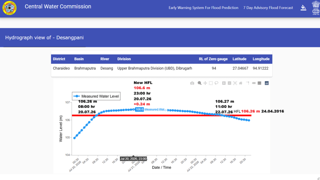
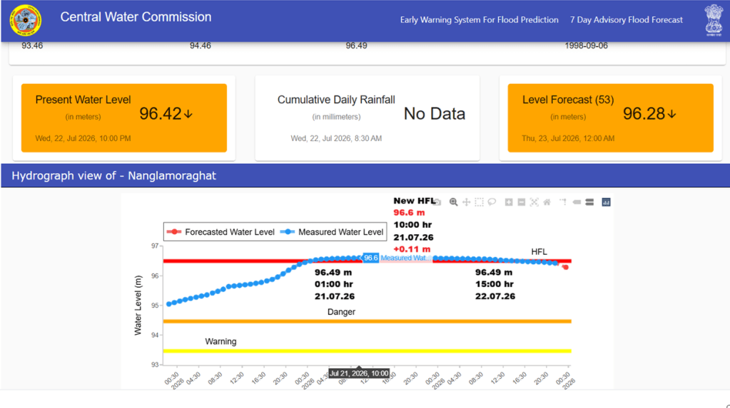
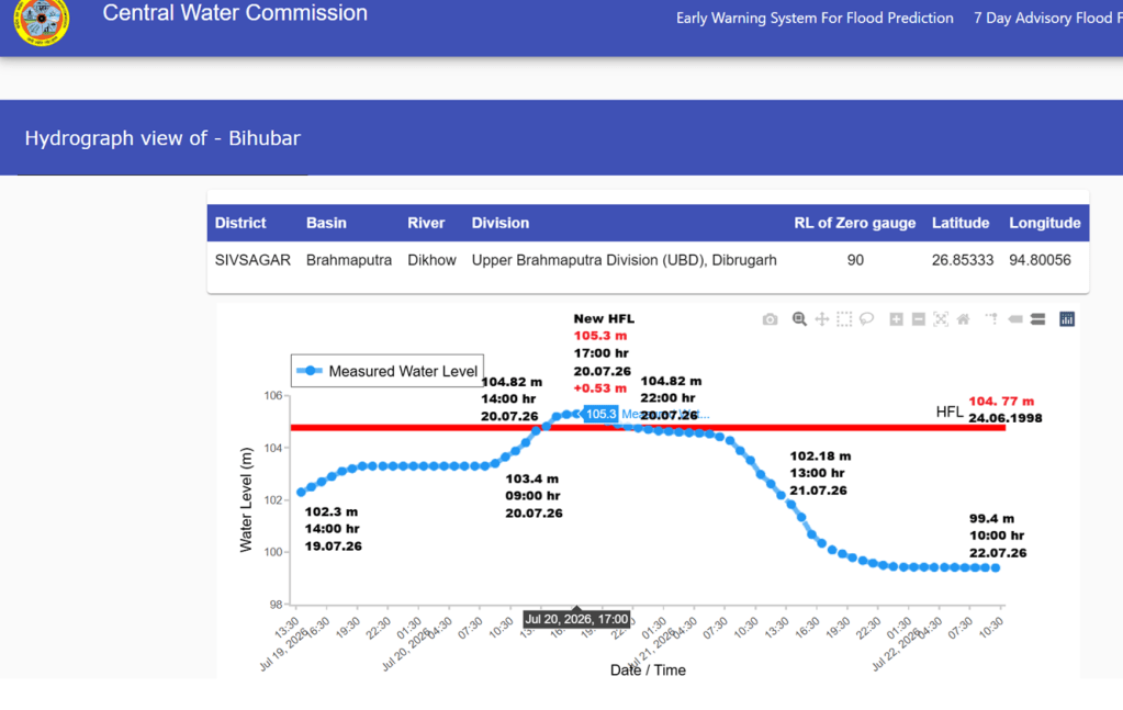
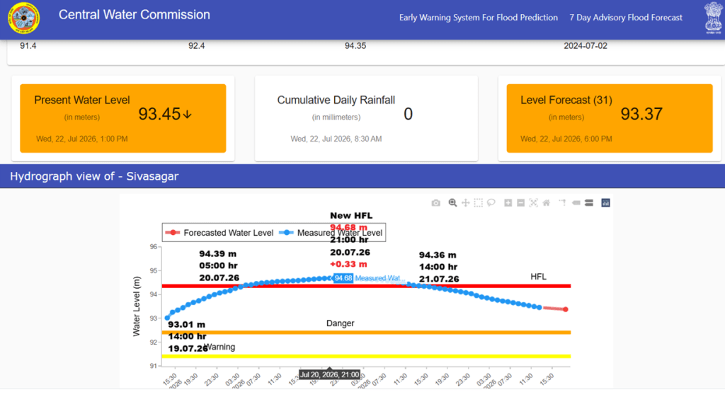
Hydrographs showing rivers breaching HFL in Brahmaputra basin in July 2026. Source: CWC
Similarly, the Dikhow river crossed its HFL at the upstream Bihubar site for the first time in 28 years. However, at the downstream Sivasagar site, the river has been crossing the HFL frequently by small margins since Aug. 2018. Both are long established monitoring sites, where the previous HFLs were recorded on June 24 and June 25, 1998, respectively.
2. Ganga Basin (Yamuna Sub-basin)
| SN | Site/ River | District/ State | Old HFL/ Date | New HFL/ Date | Rise/ Duration/ Year/ |
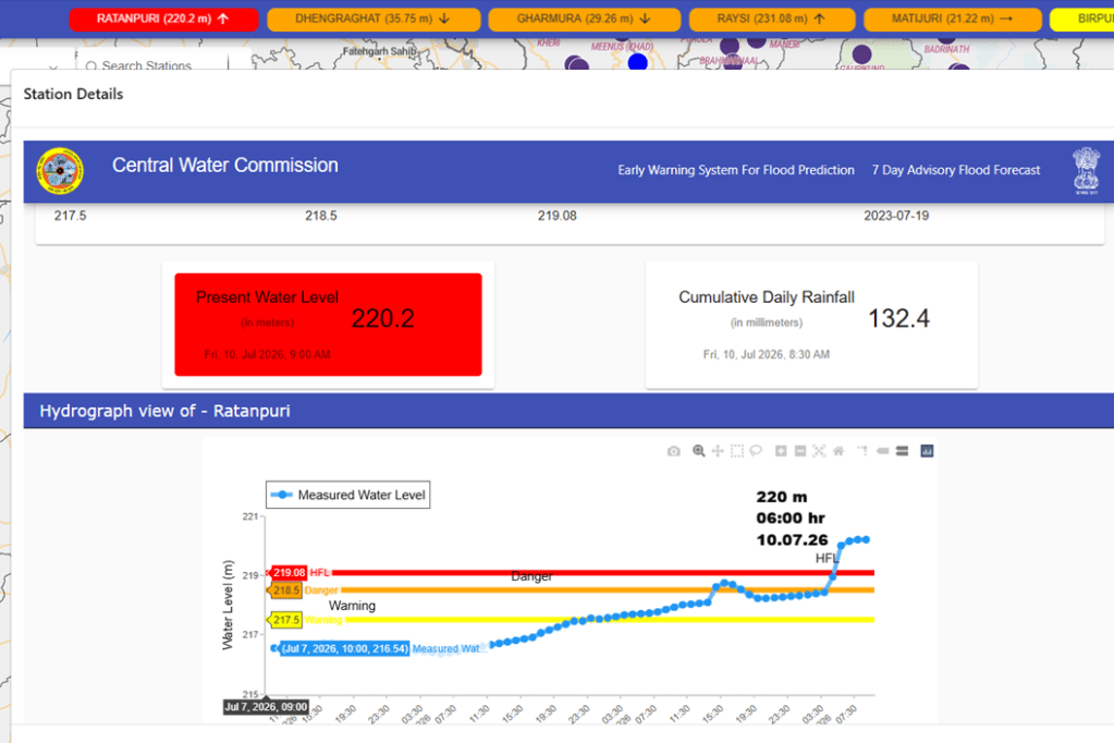
| 1 | Ratanpuri/ Kali | Muzaffar Nagar/ Uttar Pradesh | 219.08/ 19.07.2023 | 220.2 m/ 08:00 hr/ 10.07.2026 | +1.12 m/ ~04 hrs/ 03 yrs |
The HFL at the Ratanpuri site on the Kali river, a tributary of the Hindon in the Yamuna basin, was set in July 2023, when both the Yamuna and Hindon rivers experienced significant flood events in Delhi and Greater Noida.
3. Brahmani & Baitarani Basin
| SN | Site/ River | District/ State | Old HFL/ Date | New HFL/ Date | Rise/ Duration/ Year/ |
| 1 | Keonjhar/ Ararai | Kendujhar/ Odisha | 462 m/ 21.07.2009 | 463.81 m/ 16:00 hr/ 28.07.2026 | +1.81 m/ ~09 hrs/ 17 yrs |
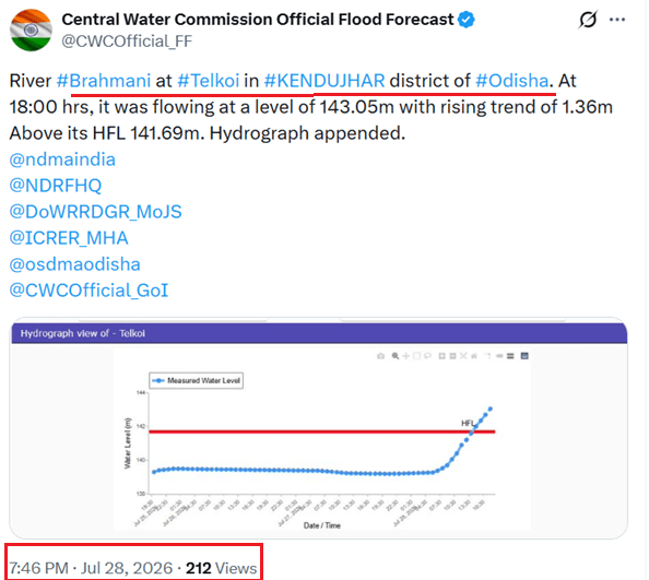
| 2 | Telkoi/ Brahmani | Kendujhar/ Odisha | 141.69 m/ 14.09.2021 | 143.45 m/ 21:00 hr/ 28.07.2026 | +1.76 m/ ~12 hrs/ 05 yrs |
| 3 | Bhadrak/ Baitarani | Bhadrak/ Odisha | 13.24 m/ 15.08.2022 | 13.53 m/ 18:00 hr/ 29.07.2026 | +0.29 m/ ~76 hrs/ 04 yrs |
The Ararai river at the Keonjhar site and the Brahmani River at the Telkoi site crossed their respective HFLs by more than 1.5 meters margin. The Baitarani River at the Bhadrak site remained in extreme flood situation for 76 hours which is the longest duration recorded among all rivers that breached their HFLs in July 2026.
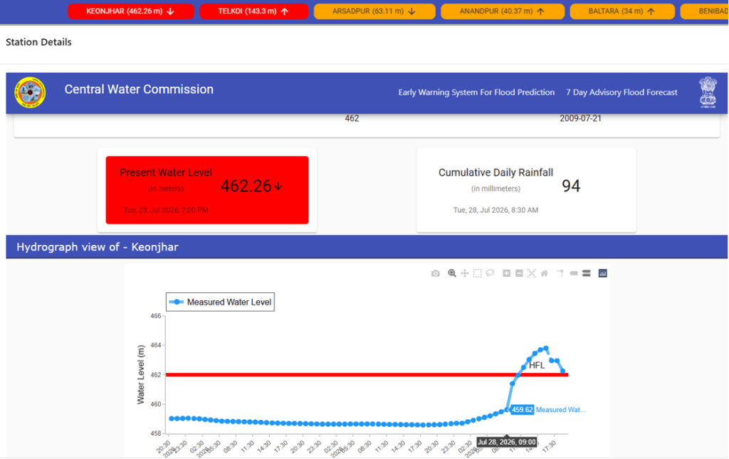
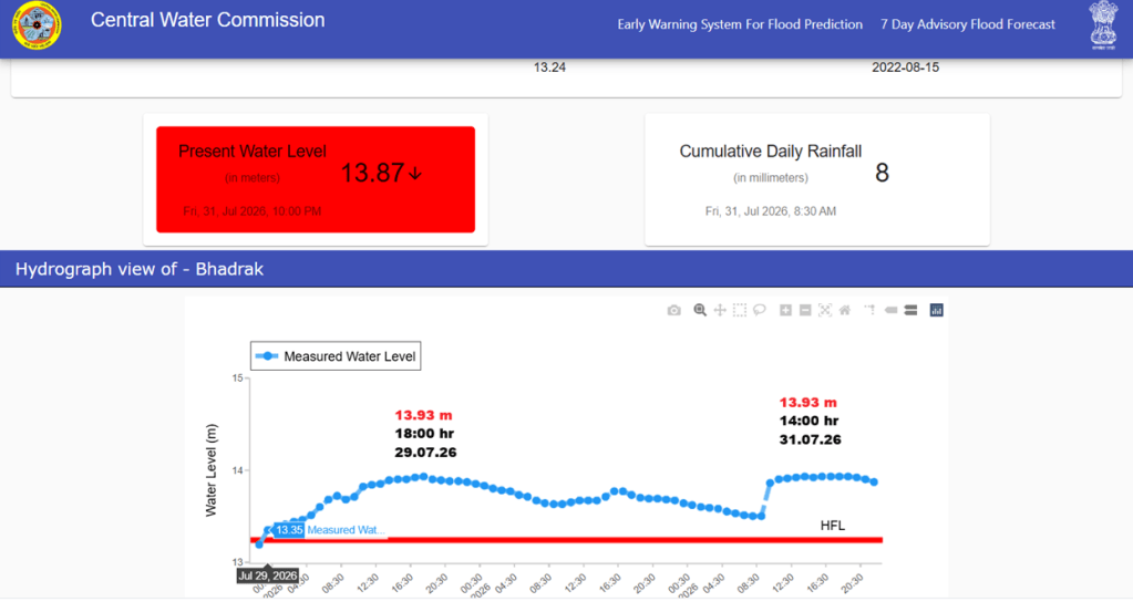
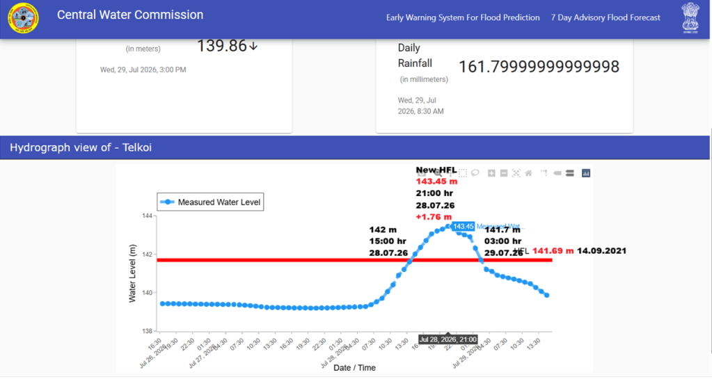
Hydrographs of rivers crossing HFL in Brahmani & Baitarani basin in July 2026. Source: CWC
4. Mahanadi Basin
| SN | Site/ River | District/ State | Old HFL/ Date | New HFL/ Date | Rise/ Duration/ Year/ |
| 1 | Katghora/ Hasdeo | Korba/ Chhattisgarh | 312.98 m/ 17.09.2015 | 313.58 m/ 13:00 hr/ 20.07.2026 | +0.60 m/ ~06 hrs/ 11 yrs |
| 2 | Malgaon/ Pairi | Gariaband/ Chhattisgarh | 327.86 m/ 16.08.2022 | 329.33 m/ 07:00 hr/ 30.07.2026 | +1.47 m/ ~16 hrs/ 04 yrs |
| 326.67 m/ 08.08.2019 | |||||
| 3 | Padampur/ Ong | Bargarh/ Odisha | 179.24 m/ 28.08.2020 | 183.13 m/ 01:00 hr/ 30.07.2026 | +3.89 m/ ~26 hrs/ 06 yrs |
| 175.53 m/ 16.08.2018 |
The Ong river at the Padampur site crossed its HFL by highest margin among all monitoring sites in July 2026. The river exceeded its previous HFL after 6 years. The new HFL recorded in July 2026 HFL is about 7.6 meter higher than the HFL recorded at the site in Aug. 2018 & 3.89 m compared to new HFL in Aug 2020.
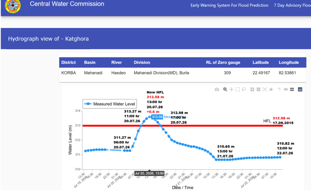
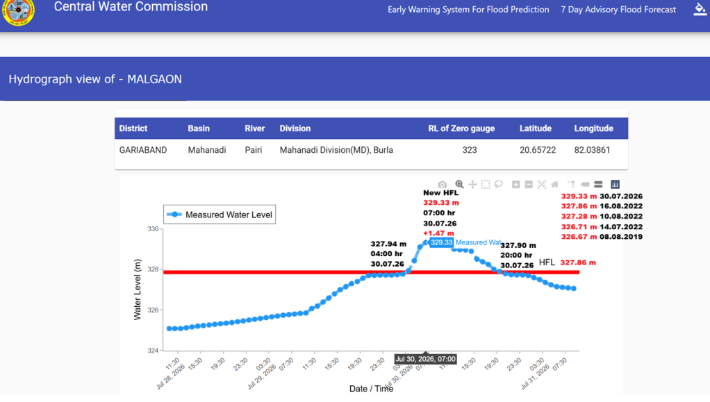
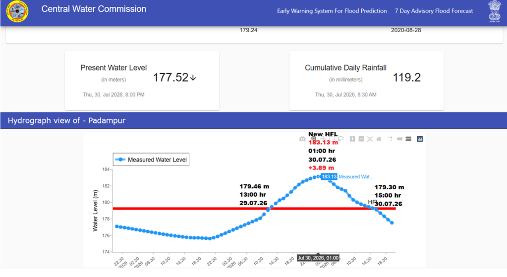
Hydrographs of rivers crossing HFL in Mahanadi basin. Source: CWC
5. Narmada Basin
| SN | Site/ River | District/ State | Old HFL/ Date | New HFL/ Date | Rise/ Duration/ Year/ |
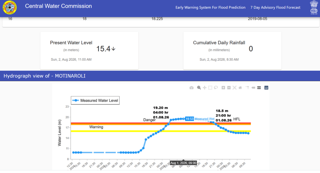
| 1 | Motinaroli/ Kim | Surat/ Gujarat | 18.225/ 05.08.2019 | 19.53 m/ 09:00 hr/ 01.08.2026 | +1.31 m ~17 hrs 07 yrs |
6. Tapi Basin
| SN | Site/ River | District/ State | Old HFL/ Date | New HFL/ Date | Rise/ Duration/ Year/ |
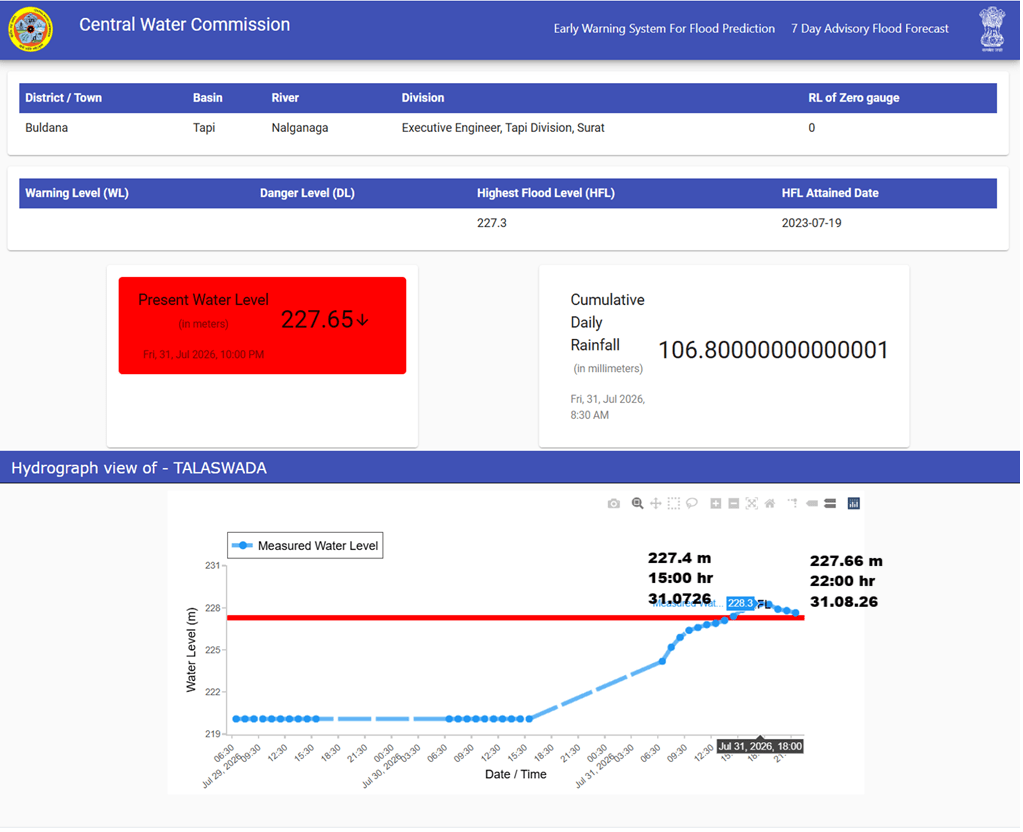
| 1 | Talaswada/ Nalganga | Buldana/ Maharashtra | 227.3 m/ 19.07.2023 | 228.3 m/ 18:00 hr/ 31.07.2026 | +1.0 m/ ~09 hrs/ 03 yrs |
| 226.1 m/ NA |
Both the Kim river at the Motinaroli site and the Nalganga river at the Talaswada site, in the Narmada and Tapi basins respectively, crossed their respective HFLs by about 1 meter, just one day apart.
7. West Flowing Rivers from Tapi to Tadri
| SN | Site/ River | District/ State | Old HFL/ Date | New HFL/ Date | Rise/ Duration/ Year/ |
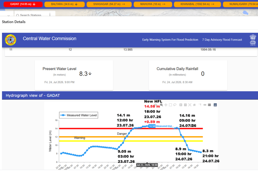
| 1 | Gadat/ Ambika | Surat/ Gujarat | 13.985 m/ 16.06.1994 | 14.58 m/ 18:00 hr/ 23.07.2026 | +0.59 m/ ~21 hrs/ 32 yrs |
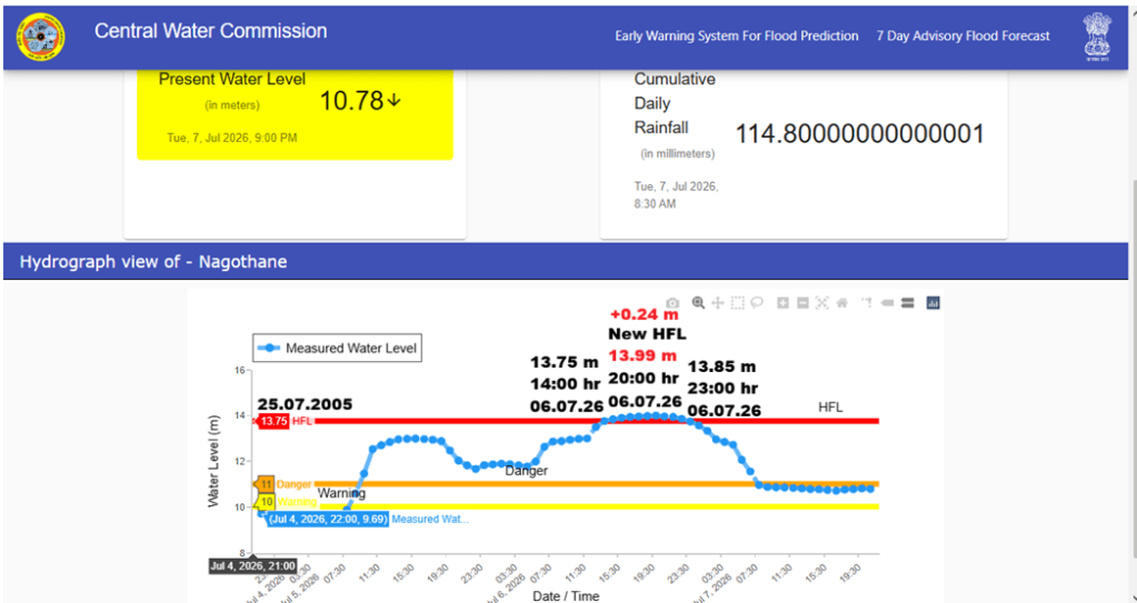
| 2 | Nagothane/ Amba | Raigad/ Maharashtra | 13.75 m/ 25.07.2005 | 13.99 m/ 20:00 hr/ 06.07.2026 | +0.24 m/ ~09 hrs/ 21 yrs |
Both, the Ambika river at the Gadat site and the Amba river at the Nagothane site breached their respective HFLs after over three and two decades, respectively.
8. Rivers reaching close to HFL in July 2026
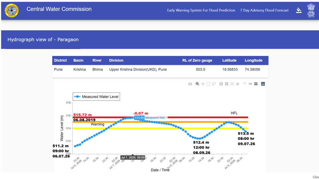
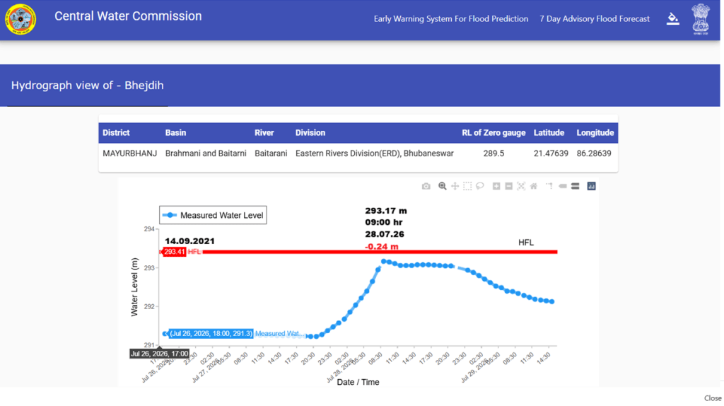
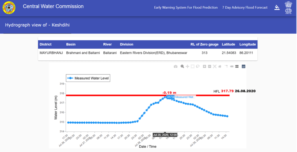
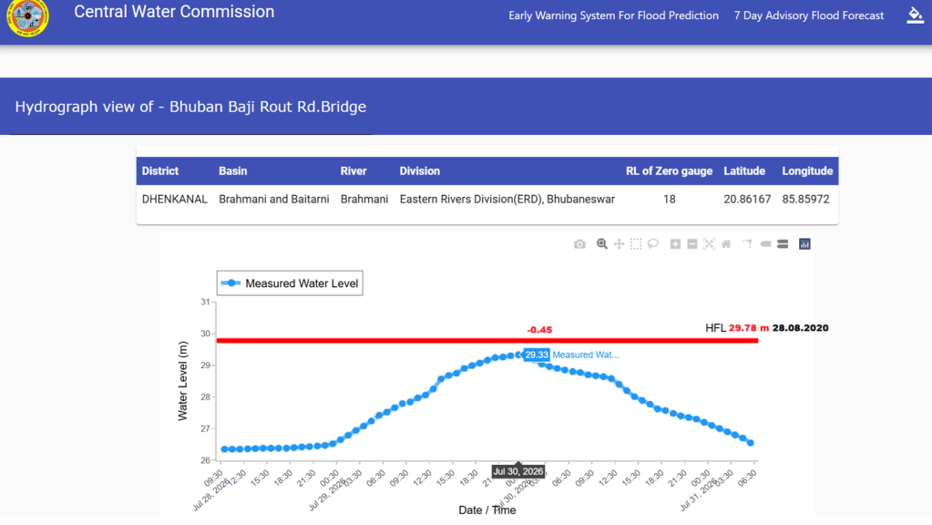
In addition to the HFL breach at 15 sites, we could track at least 4 sites where rivers missed crossing their respective HFLs with a small margin. The details of these sites are given in table below.
| SN | River/ Site | District/ State | HFL/ Date | Peak Level/ Date | Gap |
| 1 | Paragaon/ Bhima | Pune/ Maharashtra | 515.72 m/ 06.08.2019 | 515.65 m/ 09:00 hr/ 07.07.2026 | -0.07 m |
| 2 | Keshdihi/ Baitarani | Mayurbhanj/ Odisha | 317.79 m/ 26.08.2020 | 317.6 m/ 12:00 hr/ 28.07.2026 | -0.19 m |
| 3 | Bhejdih/ Baitarani | Mayurbhanj/ Odisha | 293.41 m/ 14.09.2021 | 293.17 m/ 09:00 hr/ 28.07.2026 | -0.24 m |
| 4 | Bhuban/ Brahmani | Dhenkanal/ Odisha | 29.78 m/ 28.08.2020 | 29.33 m/ 24:00 hr/ 29.07.2026 | -0.45 m |
Some Issues with CWC flood monitoring
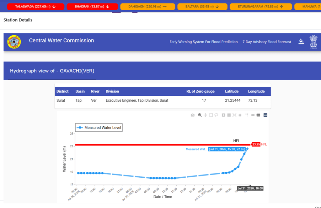
Hydrographs Lacking Hourly Flood Levels: This year we observe unusual trend at multiple sites where hourly updates of water levels are missing in their hydrographs. The Ver river in the Tapi basin at the Gavachi site in Surat district is one such example where flood level reached 22.65 meter at 15:00 hour on July 31, 2026 against the undated HFL of 23.25 meter. However, the hydrograph does not show subsequent hourly water levels, making it impossible to determine whether the river eventually crossed its HFL.
Updating HFL Before Decline in Extreme Flood Level: The Nalganga river in the Tapi basin at the Talaswada site in Buldana district is another example where hydrograph lacked hourly water level. Moreover, the CWC updated the site’s new HFL for the site to 228.30 meter without mentioning the date, even before flood level receded below the previous HFL 227.30 meter dated 19.07.2023. This is not even a new site and already had undated HFL of 226.1m before 2023 HFL. Such inconsistencies raise questions about the transparency and documentation of HFL updates.
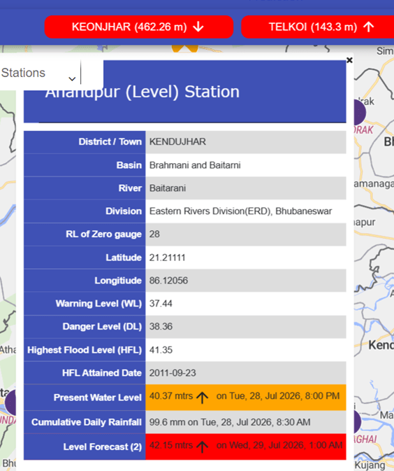
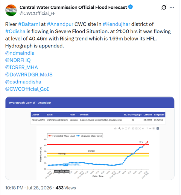
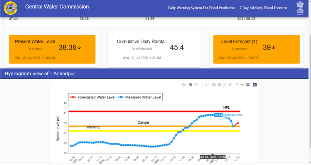
Missing Forecast: We found an instance where the CWC flood forecast falling short by 1.51 meter on 29.07.2026 than the actual flood level in the Baitarani river at the Anandpur site in Kendujhar district. The CWC made the forecast at 20:00 hour on 28.07.2026, when the flood level in the river was 40.37 meter. The CWC forecasted that it would cross the HFL (41.35 meter dated 23.09.2011) and reach 42.15 meter at 01:00 hour on 29.07.2026. However, the flood level only reached 40.64 meter at 01:00 hour on 29.07.2026.
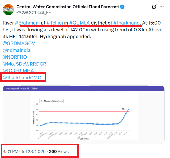
Monitoring Site Mentioned in the Wrong District: We also found an example of a basic error in reporting the location of a flood monitoring site. When the Baitarani River at the Telkoi site breached its HFL at 16:00 hrs on July 28, 2026, the CWC, through its X handle, incorrectly stated that the site was located in Gumla district of Jharkhand and issued flood alerts accordingly. About four hours later, the CWC corrected the information, stating that the monitoring site is actually located in Kendujhar district of Odisha.
SANDRP

 SANDRP