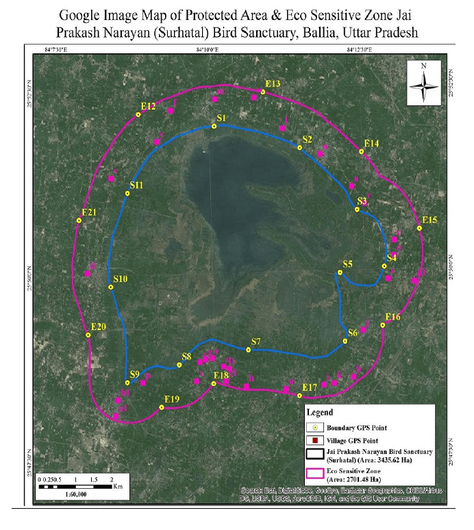
(Feature Image: MoEF&CC March 08, 2019 notification showing Suraha Tal Wetlands ESZ)
India may have proudly added Suraha Tal (Ballia) as its 100th Ramsar site this week, but ground realities tell a very different story. Even as wetlands receive international recognition, most continue to face degradation, most often due to state apathy. As we had earlier highlighted, Suraha Tal that got Ramsar tag this week, is under pressure from government-led encroachment, with construction inside its eco-sensitive zone leading to repeated flooding and damage.
Reports this week reveal the fragile state of India’s Ramsar sites. Bihar’s Kanwar (Kabar) Lake, Asia’s largest oxbow lake which got Ramsar recognition in Nov. 2020, is rapidly shrinking due to encroachment, disrupted drainage, siltation and poor water management, threatening fisheries, bird habitats and local livelihoods.
In Rajasthan, Sambhar Lake which was declared a Ramsar site in March 1990 has already lost nearly 89% of its wetland area, suffering illegal salt pans, groundwater extraction and unchecked development, raising fears that it may lose its wetland character altogether. Similarly, Kerala’s Vembanad Lake which got Ramsar tag in Aug. 2002 is witnessing a sharp decline in native fish species, with invasive species spreading due to aqua-culture expansion and flood-driven escape, severely impacting its aquatic biodiversity.
SANDRP’s 2024, 2025 and 2026 annual overviews covering several other Ramsar sites in the country highlight that these wetlands continue to face threats from encroachment, pollution, mining, govt infrastructure projects, sewage discharge, poor management and weak governance despite their protected status.
These cases amply show that the Ramsar tag has not ensured protection on the ground. Despite the rising count of Ramsar sites, ecological degradation, weak enforcement and unsustainable practices continue unabated. Instead of chasing numerical milestones, the government must prioritise scientific management, restoration of hydrology, strict regulation of encroachments and community centered ecological governance of wetlands. Without this, the Ramsar century seems like an empty symbol, while the precious wetlands continue to decline.
Suraha tal becomes India’s 100th Ramsar site The govt has designated Jai Prakash Narayan Bird Sanctuary (Surha Tal) in Ballia, Uttar Pradesh, as the nation’s 100th Ramsar site. In May 2022 blog, SANDRP has highlighted that the Suraha Tal wetland has been facing degradation due to government-led encroachment, including conversion of a memorial trust into a university and construction within its eco-sensitive zone. Flooding in 2019 and 2021 caused severe waterlogging over about 60 acres, damaging university infrastructure and disrupting academic activities, highlighting the risks of building in a natural wetland.
Asia’s largest oxbow lake faces ecological collapse A ground report from Bihar’s Kanwar Lake, Asia’s largest freshwater oxbow lake and a Ramsar wetland, highlights its rapid ecological decline. The lake has shrunk significantly due to encroachment, drainage obstruction, siltation, agricultural expansion, and poor water management. As water levels fall, fish populations and migratory bird habitats are disappearing, undermining the livelihoods of local fishing communities and reducing the wetland’s ecological value.
Residents & experts warn that despite its Ramsar status, inadequate conservation efforts & weak enforcement have allowed degradation to continue. The report notes that unless hydrological connectivity is restored, encroachments removed, and wetland management strengthened, the lake could lose much of its biodiversity and ecological functions in the coming years.
Sambhar Lake lost 89% of wetland area in 50 yrs: Study A study by the Central University of Rajasthan, published in PLOS ONE (2021), found that Rajasthan’s Sambhar Lake has lost nearly 89% of its wetland area, shrinking from 159.6 sq km in 1972 to just 17.4 sq km in 2019. Using satellite imagery, field surveys and predictive modelling, researchers warned that the lake could lose its wetland character entirely by 2059 if current trends continue.
The study identified illegal salt pans, encroachments, deep tube wells, groundwater extraction, expanding settlements and barren land as the main drivers of degradation. It noted that illegal extraction of brine and groundwater is altering the lake’s salinity & reducing water availability.
Invasive fish species threaten native biodiversity in Vembanad lake A recent study conducted by the Kerala University of Fisheries and Ocean Studies (KUFOS) and the Ashoka Trust for Research in Ecology and the Environment (ATREE) has revealed a significant decline in native fish species in the lake over the past two decades, while the population of exotic fish species continues to rise.
Experts attribute the spread of exotic fish species largely to the expansion of aquaculture and cage farming in rivers and lakes. Many farmers have established fish farms near water bodies, and during periods of heavy rainfall and flooding, fish escape into nearby rivers and eventually reach the lake.
The floods of 2018 accelerated this process, as numerous fish ponds overflowed and cage farms were damaged, releasing large numbers of exotic species into the natural ecosystem. The study also found a sharp decline in several native species, including the Kuttanad pearl spot (karimeen), prawns (konchu), snakehead murrel (varal), kari, and many other indigenous fish varieties that once thrived in Vembanad lake.
HYDRO POWER PROJECTS
Chenab-Beas Link Tunnel: Safety of the Indian Himalayan Region at Stake Parineeta Dandekar, based on field visits, interviews with local people and research, provides a detailed view of the highly disaster-prone area around the recently proposed Chenab Beas Riverlink project, whose tender was floated by NHPC last week and cancelled three days later.
Opposition to Chandra-Beas Link Project on World Env Day On World Environment Day, the Tandi Bandh Sangharsh Samiti on June 5 voiced strong opposition to the proposed Chenab-Beas (Chandra-Beas) Link Project planned near Koksar in the tribal district of Lahaul and Spiti, raising concerns over its environmental impact, lack of transparency and exclusion of local communities from the decision-making process. In a statement, Samiti president Vinod Larje said a project could have far-reaching consequences for the fragile ecology of the cold desert region of Lahaul and the Beas valley. He warned that extensive tunnel construction and blasting activities in the glacial zone around the proposed dam site could lead to the drying up of natural water sources, increased landslide incidents and irreversible damage to local ecosystems.
Raising questions over the environmental assessment process, Samiti secretary Vikram Katoch pointed out that a Cumulative Environmental Assessment (CEA) commissioned by the Central and state governments in 2019 for the Chenab river basin made no reference to the Chenab-Beas Link Project.
3-yr old swept away by water released from Sawra Kuddu HEP A three-year-old girl in Tiuni town of Dehradun district died after she was swept away by strong currents of water that was suddenly released from a hydropower project in neighbouring Himachal Pradesh into Pabbar river without warning around 11.30am on May 28. Tiuni SHO Ashwini Baluni said, “Marsika, daughter of a labourer residing in Sarnad settlement in Tiuni, was playing near the riverside with other children when the force of the water swept her away. A preliminary investigation suggests that the water was released from the Sawra Kuddu hydroelectric project”.
SLHEP PAFs demand resurvey, revised compensation Hundreds of project-affected families (PAFs) of the Subansiri Lower Hydroelectric Project (SLHEP) in Dollungmukh on June 1 demanded immediate resurvey, revised compensation, and “mandatory jungle clearance in the submergence of the SLHEP.” In a letter they submitted to the NHPC executive director, the PAFs alleged serious lapses in land assessment, compensation, and environmental safeguards at the controversial NHPC project.
The affected families claimed that the initial land acquisition of approximately 1,562.8 hectares was carried out primarily through aerial surveys, ignoring repeated demands for a proper physical ground survey. They argued that this flawed process led to significant underestimation of actual land holdings and inadequate compensation.
Centre fast-tracks 930 Mw Kirthai-II HEP on Chenab The Centre has accelerated the long-pending 930 MW Kirthai-II Hydroelectric Project on the Chenab River in Jammu & Kashmir’s Kishtwar district, transferring its environmental terms of reference to Chenab Valley Power Projects Ltd. (CVPPL) to expedite implementation. Originally conceived in 1984, the project had remained stalled for years. The move is part of a broader push to fast-track hydropower development on the Chenab after India put the Indus Waters Treaty (IWT) in abeyance following the April 2025 Pahalgam terror attack. Several Chenab basin projects that previously faced delays and objections are now being revived to enhance hydropower generation and water resource utilization in the region.
Kadamparai HEP crippled by outdates parts Commissioned in 1987, the Kadamparai Pumped Storage Hydro Power Plant, Tamil Nadu’s only PSP, is struggling to stay operational. Out of four 100 MW units, only one is generating power at present, while the rest are down due to recurring faults. Tamil Nadu Power Generation Corporation Ltd (TNPGCL) is now planning to outsource repairs and maintenance to private players. The Kadamparai Dam has a storage capacity of 1,080 mcft, while the Lower Aliyar Dam holds 937 mcft. Using a minimum of 4 mcft from the upper dam, each unit can produce 100 MW. The bidding to conduct a study on R&M was called for a few times. No one is willing to take it up as the cost may rise due to the unavailability of spare parts.
UPERC approves UPPCL procuring 511 MW of hydropower from Bhutan border at Rs 6.75 per unit The UPERC has approved UPPCL procurement of 511 MW power from Indo Bhutan border, generated at Bhutan’s Khorlochhu HEP (a Joint venture of DGPC and Tatas) at Rs 6.75 per unit for 30 years from May 1 2030. There will be no annual escalation.
DAMS
Medigadda repairs stalled amid accountability & technical challenges A year after structural problems emerged at the Medigadda Barrage, repairs remain caught between the need to restore the key component of the Kaleshwaram Lift Irrigation Scheme and the unresolved question of who should bear responsibility and costs. Detailed investigations have revealed that extensive drilling and testing are needed to assess damage beneath the barrage raft, particularly around the subsided Block-7. The scale of investigations and repair works is expected to be costly and time-consuming, complicating efforts to revive the project. Meanwhile, the Telangana government is under pressure to fix accountability for the barrage failure while simultaneously restoring a project in which thousands of crores of rupees are invested.
Mekedatu Dam: SC dismisses TN review petition as premature The Supreme Court’s dismissal of Tamil Nadu’s review petition against the proposed Mekedatu balancing reservoir has cleared a major legal hurdle for Karnataka. By ruling the challenge premature, the apex court reaffirmed that preparing a Detailed Project Report does not amount to construction approval. It also underlined a key principle: complex river management disputes must first be examined by technical bodies such as the Central Water Commission and the Cauvery Water Management Authority, and not settled prematurely through litigation. Meanwhile, Tamil Nadu Chief Minister C Joseph Vijay has sought the prime minister’s intervention.
The answer, therefore, cannot lie in competitive political rhetoric. Cauvery is among India’s most emotionally volatile inter-state disputes, capable of inflaming regional passions within hours. What is required is an institutional, science-driven framework insulated from politics. A transparent distress-sharing formula based on real-time rainfall and reservoir data, jointly monitored by Karnataka and Tamil Nadu, is essential. Simultaneously, both states must reduce dependence on fresh Cauvery water through wastewater recycling, rainwater harvesting, and crop-pattern rationalisation. Mekedatu cannot become a symbol of victory for one state and defeat for another. Unless the Cauvery basin is managed as a shared ecological and economic lifeline, legal victories alone will never produce lasting peace. (Indu Suryanarayan)
Tamil Nadu CM Vijay on May 26 wrote to PM Narendra Modi, urging the Centre not to allow the construction of the Mekedatu dam by the Karnataka government. This comes days after the Congress-led Karnataka government proposed the construction of the Mekedatu dam project across the Cauvery river. On May 25, CM Vijay held consultations with Cauvery water experts and legal specialists to discuss Karnataka’s reported plans to hold a groundbreaking ceremony for the project. Despite the legal setback, the state govt has maintained that it will continue to explore all available legal and administrative options to oppose the project. Tamizhaga Cauvery Vivasayigal Sangam general secretary P.R. Pandian, on May 31 demanded filing of contempt of court case against Karnataka CM for speaking against the SC verdict on Mekedatu Dam.
How Mumbai claims hydrological dominance in its metropolitan region The paper advances scholarship on water appropriation by examining the appropriation process at the metropolitan scale, foregrounding inequities in intra-metropolitan water distribution, and applying the lens of technopolitics to deepen insight into the processes underpinning water appropriation. It illustrates how water is legitimately appropriated for the city of Mumbai, depriving other municipal corporations, councils, and industrial centres within the metropolitan region. The paper demonstrates how technical decisions—such as adopting a river basin development approach and framing the diversion of water originally reserved for irrigation to Mumbai as a temporary and emergency measure—were strategically employed to legitimise appropriation as a natural, depoliticised process.
The river basin approach, typically perceived as promoting integrated planning, was used to carve out the Mumbai Hydrometric Area (MHA), following hydrological boundaries to gain control over water resources on the mainland. Meanwhile, framing water diversion as a technical and emergency measure assisted in avoiding potential criticism from farmers and civil society. The sense of urgency was crafted by overestimating water demand and exaggerating short-term water shortages, thereby limiting the scope for long-term solutions and presenting diversion as the only viable technical option. Through these technopolitical manoeuvres, Mumbai, geographically located on an island, legitimately secured control and selectively appropriated suitable water resources on the mainland.
Also see report based on this paper here.Mumbai receives the highest per capita supply in the metropolitan region while its control over mainland water resources is depriving others.
Survey for Bodhghat Dam begins in CG The Chhattisgarh government has restarted a survey of the long-stalled Bodhghat Multipurpose Project on the Indravati river in Dantewada, reviving a dam proposal that could submerge, fully or partially, up to 56 villages and has triggered uncertainty among tribal communities that have yet to be told where they will be resettled.
Decisions of MoEF’s Expert Appraisal Committee meeting on River Valley Projects held on May 25 2026 1. Naying Hydro Electric Project (1000 MW) in 470.8 Ha at Sub Dist Tato, Payum Circle, Dist Shi Yomi and Siang, Arunachal Pradesh by North Eastern Electric Power Corporation Ltd – Environmental Clearance: Deferred: More Info Sought: Assessment of E-Flows for aquatic biodiversity and Fish Management Plan including possibility of fish lifting arrangement
2. Duggeru Close Loop Pumped Storage Project (2500 MW) in 260 Ha at Sub Dist Makkuva and Salur, Dist Parvathipuram Manyam, Andhra Pradesh by Chinta Green Energy Pvt Ltd – Terms of References: Deferred: More info sought including updated MOU with state govt, Alternatives, component wise land requirement and source of water for construction & operation phases
3. Consideration of the proposal submitted by the NEERI for Conducting Cumulative Impact Assessment (CIA) and Carrying Capacity Study (CCS) of the Son River Basin: Sought scientifically robust, comprehensive TOR
4. Discussion on Validity of Terms of Reference (ToR) for Kirthai Stage-II HEP (930 MW) in Kishtwar District, Jammu & Kashmir: TOR transfer to CVPPL approved
5. Cumulative Impact Assessment (CIA) and Carrying Capacity (CC) Study for HEPs in the Yamuna, Tons and their tributaries: Revised report accepted
Agenda of MoEF’s Expert Appraisal Committee meeting on River Valley Projects to be held on June 8 2016 1. Indirasagar-Omkareshwar Open loop Pumped Storage Project (8×80= 640 MW) at Village- Narmada Nagar, Tahsil Punasa, District- Khandwa, Madhya Pradesh by NHDC Ltd–Environmental Clearance
2. Munjari Irrigation Project (CCA: 11575 Ha) Sub District Badoda and Karahal, Sheopur, Madhya Pradesh – Environmental Clearance
3. Dikchu Hydroelectric Power Project (96 MW) in District Gangtok & Mangan, Sikkim by Sneha Kinetic Power Projects Pvt Ltd (erstwhile Greenko Energies Private Limited)- Environmental Clearance for Expansion of Capacity (from 96 MW to 110 MW)
4. Pinnapuram Integrated RESP-Storage project (1200 MW) in Sub Dist Gadivemula, Orvakal, Panyam, District Nandyal and Kurnool, Andhra Pradesh by Greenko AP01 IREP Pvt Ltd – EC for Expansion of Capacity from 1200 MW to 1680 MW
5. Formation of reservoir across Koraiyar river in Vickramasingapuram village of Ambasamudram Taluk in Tirunelveli District, Govt of Tamil Nadu- Terms of Reference (This last agenda was added on June 2 2026)
IRRIGATION
Haryana’s ₹489-cr canal project remains unfinished The Haryana govt approved the Remodelling of Augmentation Canal project in Dec 2017 at an estimated cost of Rs 489 crore. Passing through Yamuna Nagar and Karnal districts, the project was designed to increase the canal’s carrying capacity from 3,100 cusecs to 6,000 cusecs, strengthening the Western Yamuna Canal system. Work was to begin in 2018-19 and be completed by 2020-21. Nearly five years after that deadline, it remains incomplete. Sources familiar with the project said around Rs 350 crore has already been spent, though the irrigation department’s latest expenditure figures could not be independently verified.
Water experts estimate that significant quantities are lost through seepage and transmission in the Western Yamuna Canal network — sector estimates suggest losses of 600-800 cusecs in parts of the system. Conserving even a fraction of these losses, they say, could improve availability during peak summer months. Nitin Bassi, fellow at CEEW, said the capital’s water supply had fallen to about 70% of total demand of 1,250 MGD — a gap further widened by leakages and theft amounting to roughly 40% of supplied water. He argued that a circular water economy, including reuse of treated wastewater for horticulture, landscaping and industrial cooling, was critical. “In many cities, reuse remains below 3% of total freshwater demand. Ideally, it should be at least 20%, which would free up water for domestic use during summers,” he said.
URBAN RIVERS
3,000 tonnes of waste choke Dakshina Pinakini river Several hundred truckloads of waste dumped over the past two months have impacted the Dakshina Pinakini River in eastern Bengaluru, raising concerns over environmental damage, illegal waste handling, and regulatory lapses. Drone images accessed by DH reveal a huge volume of garbage covering marshy portions of the riverbed, with heaps of waste stretching across a large area. Based on rough estimates, more than 3,000 tonnes of waste have been dumped at the site. Residents allege that 10 to 15 truckloads of waste were unloaded daily, initially on private property adjoining the river, before the dumping gradually extended into the buffer zone and eventually encroached upon the river itself. The dumping reportedly continued unchecked for weeks before authorities intervened. Environmentalists warn that the continued presence of thousands of tonnes of waste in and around the river poses a major ecological threat.
Death of Mula river On the World Environment Day, Vishwashanti Darshan released a video “Death of a River – Mula”, highlighting the severe pollution and degradation of Pune’s Mula River. The film serves as a wake-up call on the consequences of unchecked waste dumping and river neglect. Students of MIT ADT University have pledged to take action and ensure that no more garbage is dumped into the river, promoting community participation in its conservation.
RIVERS
CALL FOR FILMS : 7th NADI UTSAV 2026 Are you a filmmaker, documentary creator, student filmmaker, visual storyteller, or river enthusiast? The 7th Nadi Utsav invites film submissions under the theme: The River as an Archivist. From memories and heritage to ecology, culture, communities, and changing landscapes, rivers preserve stories across generations. We invite films that explore these narratives through creative and documentary formats.
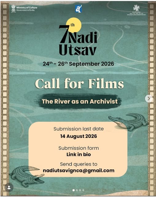
Film Categories: 1. Spandan – The Pulse (Reel/Short Video upto 50 sec)
2. Dhara – The Stream (Short Documentary upto 20 min)
3. Pravah – The Flow (Full-Length Documentary upto 50 min)
Submit by: 14 August 2026 https://ignca.gov.in/invitations/02062026-7th-nadi-utsav-film-festiva.pdf
Call for Papers: 7th Nadi Utsav (2026) Yamuna – a witness to history, a bearer of memory, a cultural force, and a living ecosystem that continues to shape millions of lives. As part of the 7th Nadi Utsav, IGNCA, in collaboration with the Department of English, University of Delhi, invites abstracts for the national seminar: “The Eternal Yamuna: Chronicles of Conflict, Biotic Healing, and the Socio-Cultural Hearth”. We welcome interdisciplinary perspectives that explore the Yamuna through culture, ecology, history, literature, livelihoods, heritage, and conservation. Last date for abstract submission: 19 June 2026; Abstract: 250 words | Bio: 100 words; nadiutsavignca@gmail.com
India’s rivers that flow westward The report highlights the unique courses of the Narmada River and Tapi River, two major Indian rivers that flow westward into the Arabian Sea, unlike most Indian rivers that flow east toward the Bay of Bengal. The Narmada’s unusual direction is due to its passage through a geological rift valley between the Vindhya and Satpura ranges, which creates a natural east-to-west slope. This makes the river geologically distinct and one of India’s most important river systems.
The Nilgiris is not just a wildlife story The hills are the source of major river systems, including the Bhavani, Moyar, Pykara and Sigur, all feeding into the Cauvery basin, eventually bringing water to homes and farms across states. The Shola grassland ecosystem, which is a combination of dense evergreen forest and open rolling grassland found only in these highlands, works like a giant sponge. It soaks up monsoon rain and regulates groundwater recharge across the plains.
Godavari river pollution sparks health concerns Concerns over the deteriorating water quality of the Godavari, a major tributary of the Vasista Godavari River in West Godavari district, have intensified following alarming findings on pollution levels and public health risks. The issue gained renewed attention after Deputy CM Pawan Kalyan expressed concern over contamination, warning that while people may seek spiritual merit through a holy dip, polluted waters could instead expose them to disease.
Waste dumping along Beas in Kullu On May 8, 2026, the NGT again had to rule on garbage management issues in Kullu Valley of Himachal Pradesh. The case, Sanjeev Kapoor vs the Municipal Council of Kullu, related to the public place called Nehru Park in Kullu being used to set up a material recovery facility (MRF) for waste management. The NGT called on the administration to halt all activities taking place in the public park, as they are illegal. According to the Waste Management Rules 2016, as stated by the applicant Sanjeev Kapoor in his petition, the law provides that MRF plants can’t be situated within 100 metres of a river point. The MRF in question was being created within 30 metres of the Beas river in the Sarvari ward of Kullu.
On the upper reaches of the Gangotri Valley, in the area of Dharali and Harshil, amidst glaciers, pristine waterfalls, and sheer cliffs, a magnificent and dense deodar forest flourishes, with 5 glacier-fed streams also flowing through the area. The girth of the 4,000 tall cedars indicates an age of at least 100 years. Interspersed are oak, chestnut, sea buckthorn, cypress, birch, and other rare species. The entire forest of 7,000 trees is growing on loose avalanche debris, and, thereby, the roots of this ancient forest also stabilise this vulnerable terrain.
On Aug 5 last year, there was the collapse of an ice sheet into Kheer Ganga Gaad above Dharali, leading to an avalanche in the stream. The debris-laden stream then wiped out the largely illegal settlement of Dharali at its base, on its confluence with the Ganga. Consequently, the Harshil Gaad, Jhaala Gaad, Loharinag Gaad, and Limchi Gaad also flooded one after the other.
It took just a few minutes to deposit 50 acres of debris and sludge, weighing 2,50,000 tonnes and 50 feet high, under which a group of 24 childhood friends on a reunion trip were instantly buried alive, as were several workers from Nepal, tourists, and locals. The impact was so severe that the Ganga was also temporarily blocked, creating a lake that posed a threat to the entire valley downstream.
Such horrific disasters are the new normal in the Himalayas, especially Uttarakhand. The Gangotri valley, notified as an eco-zone, has strict regulations for protecting this watershed, which is the origin of the Ganga. It has one of the largest glacier systems in the Himalayas; hence, even the High Powered Committee (HPC) monitoring the ambitious Chardham road-widening project (CDP) recommended that a detailed EIA be done before commencing any works in this valley. The CDP has left a trail of over 800 landslides in its 800 km of completed work so far. The HPC also recommended against the felling of this forest. The Supreme Court had ruled in 2021 that these recommendations were binding on the Ministry of Road Transport and Highways (MoRTH).
7,000-tree felling plan puts fragile Gangotri valley at risk In February this year, Dr Murali Manohar Joshi, Dr Karan Singh, Govindacharya, and Revati Raman Singh wrote to the minister of transport, Nitin Gadkari, cautioning against putting the Himalayas at risk. They cited the precautionary principle, which mandates that where there is a reasonable likelihood of serious or irreversible environmental harm, the absence of absolute scientific certainty cannot be a ground for proceeding with destructive activities. In other words, risks should not be taken with people’s lives and the environment. They requested a narrower road width, keeping in mind the Dharali disaster, and requested that the felling of 7,000 trees be cancelled.
The only change MoRTH made in response to this grave concern was changing the formation width of the road from 12m to 11m. Practically, such a marginal reduction is unlikely to result even in a minor reduction of environmental damage, as various critical parameters of tree felling, deodar felling, soil loss, forest loss, hill cutting, muck generation, and dumping will not be significantly reduced. Most critically, it will hardly reduce hill cutting, which is the key trigger for landslides, slope failures, and a chain of other irreversible destruction. (Priyadarshini Patel)
Genesys bags NMCG contract for Ganga aerial survey The project covers the Ballia-to-Farakka stretch of the Ganga across Uttar Pradesh, Bihar, Jharkhand and West Bengal. Genesys will deploy a combination of manned aircraft and unmanned aerial vehicles (UAVs) to capture geospatial data along the river corridor and its associated drainage systems. Deliverables include 3D LiDAR point clouds, orthorectified imagery, photogrammetric data and geotagged aerial video of natural and manmade drains feeding into the river. The company says the resulting dataset is intended to support drainage mapping, pollution hotspot identification, floodplain analysis and wastewater interception planning for river basin management.
DDA’s zone O markers raise eviction fears The Delhi Development Authority (DDA) has installed “Zone O” signboards across parts of the Yamuna floodplains, triggering concerns among residents about possible demolition drives and eviction. Many people living in settlements and villages along the floodplain fear the signboards signal stricter enforcement following recent court directions to protect the river’s floodplain from encroachment and unauthorized construction. Officials, however, said the boards are intended to mark and identify the regulated floodplain area, where construction and land-use activities are subject to environmental restrictions. The development comes amid increased scrutiny of activities on the Yamuna floodplains and efforts to preserve the river’s ecological zone.
The tragic death of Hindon The video report highlights the severe pollution crisis in the Hindon River, once a vital lifeline of western Uttar Pradesh, now reduced to a “dead river” due to unchecked urbanisation, industrial waste, untreated sewage, and plastic dumping. It warns that rapid development in Noida, Greater Noida, and Ghaziabad is degrading the river, threatening groundwater quality, ecosystems, and public health, while raising concerns about whether meaningful revival is still possible.
Ghaziabad to start eviction drive in illegal colonies along Hindon Days after the UP govt informed the National Green Tribunal that 258 unauthorised colonies in Ghaziabad were discharging untreated sewage daily into the Hindon, district magistrate Ravindra Kumar Mandar on June 05 directed officials to launch a coordinated drive to identify and remove encroachments along the river. The directions, issued at a meeting with officials from the Loni SDM’s office, irrigation department, GDA and municipal bodies, require teams to cross-reference revenue records, irrigation data and maps against ground conditions to pinpoint illegal occupations.
RIVERS BIODIVERSITY
BNHS launches India’s first telemetry study of River Lapwings in Ganga basin As part of the initiative, the BNHS Bird Ringing and Monitoring Station (BRMS) team in Bhagalpur, Bihar, fitted GSM-GPS transmitters on four River Lapwings on a sandbar near Barari Ghat, marking the beginning of a long-term effort to track the species’ movements and behaviour in its natural habitat. BNHS researchers believe the telemetry project will help fill these critical knowledge gaps by providing real-time information on how the birds use river habitats throughout the year.
Conservationists say the study comes at an important time as India’s river ecosystems are facing increasing pressure from habitat alteration, river regulation, infrastructure development and growin human activity along riverbanks. Researchers hope the findings will contribute not only to the conservation of the River Lapwing but also to broader efforts aimed at protecting the fragile riverine landscapes of the Ganga and other major river systems in India.
Monsoon variability & human impact shape Majuli’s ecosystem The study reveals that Majuli Island’s climate and vegetation over the past 4,000 years have been shaped by strong monsoon variability, shifting between warm–humid, wetter, and cooler–drier phases. It highlights increasing flood activity and a clear rise in human influence after 1450 CE, with agriculture altering natural ecosystems, showing the region’s high sensitivity to both climate change and human pressures.
FISH, FISHERIES, FISHERFOLKS
Hundreds of fish float dead in TN’s Vilathikulam Hundreds of fish died in the Ambal Nagar kanmani (waterbody) in Vilathikulam town. The public sought immediate clearance of the dead fish as an unbearable stench pervaded the area. Sources say the Ambalnagar tank of the Public Works Department (PWD) is the source of water for nearly 18 villages. The tank receives water from rains and from jungle streams of Sithavanayakkanpatti, Mettupatti, Aatrangkari, Kandasamypuram and other villages.
Pointing to pollution, the public alleged that wastewater from the streets of Ambalnagar are drained directly into the waterbody spread over 60 acres due to the absence of a proper wastewater disposal system. Also, the water of the tank remains unusable as it was not desilted for more than 20 years. Also, the severity of the pollution is high as water level has reduced due to summer. This had resulted in the death of fish, said an official of the Vilathikulam town panchayat, adding similar deaths of fish had occurred here especially before summer seasons.
Mass fish death at Bengaluru’s Sunkalpalya Lake Hundreds of fish deaths have been reported from Sunkalpalya Lake under Bengaluru West City Corporation (BWCC) over the past three weeks due to suspected water contamination and a decrease in Dissolved Oxygen levels. A resident and a walker who noticed dead fish floating and a few gasping for breath say the Greater Bengaluru Authority (GBA) officials, when contacted, were just passing the buck.
Mass fish death in Delhi’s Sanjay Lake: Mismanagement, not heatwave, says SANDRP
SAND MINING
Finish probe, speed up trial in illegal sand mining case: HC The judge observed that sand mining by private individuals is prohibited in Tamil Nadu with effect from 2003 under Rule 38-A of Tamil Nadu Minor Mineral Concession Rules 1959. According to this rule, the right to exploit sand in the state is vested with the state govt alone. However, in this case, a person from Kerala has taken sand illegally from the banks of Thamirabarani and illegally transported it in the name of m-sand to Kerala. The first accused has committed this offence with the connivance of the officials. The petitioner and other officials had facilitated the crime by issuing work orders for constructing bogus farm ponds in order to legalise the mining operations.
This episode clearly shows the manner in which the offenders are escaping accountability and punishment for their actions. Therefore, the director of geology and mining shall look into this issue and ensure that the inquiry pending is completed at the earliest, the judge said. Since the final report has been filed, CB-CID, which has conducted the investigation in an effective manner, shall ensure conclusion of trial at the earliest. The suspension of the petitioner may be revoked and he may be placed in any non-sensitive post after consultation with the investigating agency pending the outcome of the criminal case, the judge observed.
The judge noted that the initial charges framed against him by the inquiry officer on technical grounds were proved and he was punished with a stoppage of increment. However, the CB-CID filed a final report in the case in July last year, which included additional charges against the petitioner and two more officials including an assistant director of geology and mining department.
Due to this, Ponnudurai’s request for revocation of suspension was rejected by the government, the judge noted. Though he did not find fault with the government’s decision, he noted that the office cannot be indefinitely placed under suspension without extracting any work from him.
Black sand, broken shores Residents of Thottappally in Kerala’s Alappuzha district have spent years resisting large-scale sand mining that they say has accelerated coastal erosion, damaged fragile ecosystems, and threatened livelihoods.
WETLANDS, LAKES, WATER BODIES
HC takes notice of wetland degradation across Rajasthan The High Court has initiated a suo motu Public Interest Litigation (PIL) on the deteriorating condition of wetlands across the state. The Court noted that Rajasthan has around 46,748 wetlands, but only a small number have been notified for statutory protection, while many face threats from encroachment, sewage discharge, pollution, waste dumping, shrinking water spread and inadequate conservation measures.
The Court directed the State Government, State Wetland Authority, Pollution Control Board and district administrations to submit detailed status reports on wetland inventory, GIS mapping, boundary demarcation, encroachments, pollution sources, Ramsar sites, biodiversity conservation and restoration measures. It also ordered a statewide wetland survey, prevention of new encroachments, prohibition of untreated sewage and industrial effluents entering wetlands, and preparation of a time-bound conservation roadmap. Three advocates were appointed as Amicus Curiae to assist the Court. The matter has been listed for further hearing on 6 July 2026.
WATER OPTIONS
Retired teacher offers water-saving alternative Jarnail Singh, a resident of Mothawal village, dedicated his career to teaching before venturing into farming after retirement. He moved to Uttar Pradesh about 13 years ago due to personal reasons, where he successfully cultivated groundnuts on nearly 20 acres of land. Armed with experience, determination and a vision to conserve groundwater, Singh returned to Punjab four years ago with a wish to promote the crop among local farmers. Leading by example, Singh expanded groundnut cultivation to 26 acres this year. His efforts have encouraged fellow farmers, resulting in the area under spring groundnut cultivation in Kapurthala district increasing to 72 acres.
GROUNDWATER
Toxic metals in wells in Vaniyambadi in Tamil Nadu A study from Tamil Nadu’s Vaniyambadi region finds toxic metals and rising salinity in groundwater, exposing hidden risks to drinking water, farming, public health and long-term water security.
India’s hidden water subsidy of groundwater extraction is collapsing Groundwater extraction functions as a hidden subsidy sustaining development while its long-term costs remain deferred across generations.
Groundwater crisis deepens agrarian distress in Panna The report highlights how falling groundwater levels in Madhya Pradesh’s Panna District are pushing farming communities into a severe crisis. Years of excessive groundwater extraction, erratic rainfall, and inadequate water management have left many wells and borewells dry, reducing irrigation availability and crop productivity. Farmers are forced to invest heavily in deeper borewells, often falling into debt, while many small and marginal farmers struggle to sustain agriculture.
The report notes that groundwater depletion is not only affecting livelihoods but also increasing social & economic vulnerability, with some families reducing cultivation or seeking alternative income. Experts warn that without better groundwater governance, recharge measures, and sustainable farming practices, the region’s water and agricultural crisis is likely to worsen.
URBAN LAKES, WETLANDS
Dal and Anchar lakes face growing crisis The report examines the deteriorating condition of Kashmir’s Dal Lake and Anchar Lake, which are under increasing pressure from urban expansion, encroachment, sewage inflows, and pollution. Once vital wetlands supporting biodiversity, fisheries, flood regulation, and local livelihoods, both lakes have witnessed shrinking water spread, excessive weed growth, siltation, and declining water quality.
While restoration efforts have focused largely on Dal Lake, experts and local residents argue that Anchar Lake has received far less attention despite facing similar threats. The report warns that continued neglect, unregulated development, and inadequate wastewater management could further degrade these ecologically important water bodies and undermine the livelihoods of communities dependent on them.
Protest against poor state of Sankey Tank in Bengaluru Residents of Sadashivnagar and environmental activists initiated “Save Sankey Tank” campaign on Sunday to raise concerns over the deteriorating condition of Sankey Tank, alleging sewage inflow, blocked rainwater inlets, concretisation and ecological degradation at the iconic lake. The residents said the lake’s water levels has drastically reduced despite heavy rainfall in Bengaluru last year. The depletion exposed drains inside the lake, making sewage inflow clearly visible.
Barriers fail to stop plastic flood into Seegehalli Lake in Bengaluru Lake activists are unhappy with Bengaluru East City Corporation’s work of installing trash barriers at inlets to prevent garbage from entering Seegehalli Lake. Despite these barriers, garbage and floating materials like plastic have made their way into the water body in the last month because of heavy rain.
NGT seeks report on illegal landfilling in Thane’s mangrove area Taking serious note of allegations of illegal dumping and landfilling in protected mangrove and wetland areas in Thane, the NGT, Western Zone, Pune, has sought detailed replies from key authorities by July 09. Petitioners alleged that the landfilling activity in Saket and Rabodi obstructs natural drainage channels and could increase flooding risks in nearby residential areas during the monsoon.
The petition was filed by environmentalist Rohit Joshi, NGO Vanashakti and residents of Akash Ganga Housing Society, who alleged that large-scale landfilling was being carried out in ecologically sensitive CRZ-I areas. According to the petition, the alleged activity is taking place on a 10-hectare plot at Survey No. 386 near the Saket Police Ground. Land records reportedly show the Thane police commissioner as the occupant of the land. The petitioners claimed that the alleged landfilling, ongoing since November 2025, has obstructed natural drainage channels that carry rainwater from residential areas to the creek.
NGT seeks govt reply over Padampur bus stand project The controversy centres on a plan by the state transport department to construct a bus stand by reclaiming nearly two acres of a pond area locally known as ‘kata’. The project was challenged before the NGT by 75-year-old resident Alaka Mishra and eight other residents of Padampur, who argued that the water body plays a vital ecological role and should not be disturbed. The NGT’s east zone bench in Kolkata first issued notices to state authorities last Aug. Subsequently, on Sept 16, the tribunal directed officials to maintain status quo regarding the nature of the land and any construction activity on the site, which the petitioners claim is a water body.
However, while the matter remained pending before the tribunal, the petitioners filed a fresh application on May 21 alleging that the transport department floated a tender on March 30 for construction of the bus stand at an estimated cost of Rs 28.75 crore. According to the plea, issuance of the tender signalled an intention to proceed with filling up the pond, potentially defeating the purpose of the ongoing litigation. The petitioners, represented by advocates Sankar Prasad Pani and Ashutosh Padhy, contended that any such move would render the main case infructuous. Taking note of the allegations, a bench comprising judicial member Sheo Kumar Singh and expert member Ishwar Singh issued fresh notices to the additional chief secretary of the revenue and disaster management department, principal secretary of the commerce and transport department, Bargarh collector, Padampur tehsildar and the regional transport officer, Bargarh. The bench also extended the interim status quo order “till the next date of listing” and directed that the matter be listed on Aug 12. The order was released online on May 29.
URBAN WATER
Water tankers to go off Mumbai roads from June 8 Even as the city is facing a 10% water cut, the Mumbai Water Tanker Association (MWTA) has warned that all tanker operators across Mumbai will take their vehicles off the roads and suspend water transportation services throughout Mumbai from 12 am on June 8 until further notice, in view of “harsh and selective” implementation of Central Ground Water Authority (CGWA) rules exclusively in the city and notices issued to well operators and water suppliers.
This, according to the association, has affected water tanker operators, well owners, ring well owners, borewell operators & water suppliers. Notices are being issued by revenue authorities & BMC to the well owners regarding licences, and power supply of some well owners has been disconnected. The association has sought a meeting and intervention from the chief minister.
The association has pointed out that the CGWA guidelines mandate that a licence will be issued to a well owner only if the well is situated on a land parcel having a minimum size of 200 square metres, which is impractical in a city like Mumbai. Last year, too, the civic body had issued notices directing the well owners to seek NOC from the CGWA.
TNUHDB residents plagued by water woes for four months Thousands of families living in the Tamil Nadu Urban Habitat Development Board (TNUHDB) tenements in Kannagi Nagar, Ezhil Nagar & Tsunami Quarters near Sholinganallur have raised concerns over the continued water shortages, forcing residents to spend hrs every day waiting to collect water for their basic needs.
These resettlement sites, which house more than 20,000 families, depend entirely on water supplied by the Chennai Metropolitan Water Supply and Sewerage Board (CMWSSB), as groundwater in the area is saline and unfit for drinking. Water is first stored in common sumps and then distributed to households through overhead tanks. But, for almost four months now, the water supply in the area remains inadequate due to low pressure, said the residents and added that it has disrupted their daily routine.
KWA, Kochi Corpn. to conduct joint inspection over alleged water contamination The Kerala Water Authority (KWA) and the Kochi Corporation will jointly conduct an inspection to assess drinking water quality on June 8, 2026 in the wake of alleged water contamination in three divisions of the Corporation. Around 60 residents of the Kadavanthra, Panampilly Nagar and Perumanoor divisions reportedly complained of diarrhoea and vomiting after allegedly consuming drinking water supplied by the KWA. Councillors representing the divisions alleged that contamination of the KWA’s water supply was behind the incident. The civic and health authorities conducted awareness campaigns and initiated chlorination in the region.
Residents protest sewage discharge into Puducherry SWD Residents of Puducherry have raised concerns over the discharge of untreated sewage into a stormwater drain, alleging that it has caused foul odours, water contamination, and public health risks. Local people say the drain, originally meant to carry rainwater, is increasingly being used to channel sewage due to inadequate wastewater management. They have demanded immediate intervention by authorities to stop the discharge, improve sewage treatment infrastructure, and prevent further environmental degradation.
Delhi parched despite being a river city The report highlights Delhi’s recurring water crisis despite being located on the banks of the Yamuna. A sharp decline in Yamuna water levels at the Wazirabad pond and reduced raw water availability have affected production at major water treatment plants, leading to water shortages in several parts of the city. Delhi remains heavily dependent on water supplied by neighbouring states, while ageing infrastructure, transmission losses, unequal distribution, groundwater depletion, and rising summer demand continue to worsen the crisis. The government has responded with tanker deployment, water rationing, rainwater harvesting initiatives, and plans to rationalise water distribution, but the report argues that long-term water security will require systemic reforms and better water management.
Yamuna hits historic low in Delhi Parts of Delhi continued to remain parched on May 31, the 10th day, with truncated water supply in several areas of central, north, northwest, and south Delhi on account of the dry Yamuna being unable to provide raw water to the city’s largest water treatment plants – Wazirabad and Chandrawal – for producing drinking water. The Yamuna level has dropped to 668 feet, 6.5 notches below the normal level and close to a historic low of 667ft recorded in 2021.
Crisis worsens at Delhi’s Gulmohar Park More than a week after residents of South Delhi’s Gulmohar Park began complaining of foul-smelling and contaminated water supply in parts of the colony, the crisis has now spread across several lanes, with households reporting illness, hospitalisation and acute shortage of clean water. even as repair work by the Delhi Jal Board (DJB) continues. According to residents, many families have stopped using piped water and are now dependent on DJB and private tankers as well as packaged drinking water. The latest crisis comes days after authorities inspected possible contamination points near Gate 2 and other parts of Gulmohar Park, developed in the early 1970s.
How urban water systems fail There are underlying systemic factors that lead to the mixing of sewage water with drinking water. From an engineering perspective, the risk of contamination in drinking water pipelines is almost always present: sewage water can enter through even minor leaks and openings in the water pipes, especially when the water supply has been cut off and the pressure in the pipes is slack.
This issue is exacerbated when the pipe network is aged and corroded, when pipes are damaged in construction activity, or when sewage flows and other contaminants come into the area around the pipes. There are two important policy takeaways from this perspective. One, that that the risk of contamination of drinking water is almost always present, and that it can only be managed, rather than completely eliminated. Second, as the risk to drinking water is from the close interaction of sewage and drinking water pipes, its management requires attention to both drinking water and sewage. (Arkaja Singh)
64% of Gurugram’s RWH pits still clogged before monsoon Municipal Corporation of Gurugram (MCG) officials said only 150 of the 408 existing rainwater harvesting systems have been cleared so far, while work on the remaining 258 pits is underway. Among the city’s four zones, 66 rainwater pits have been desilted in Zone 1, 28 of the 47 pits in zone 2, while zone 3 has seen the slowest progress with only 24 of the 121 pits cleared. In zone 4, desilting has been completed in 32 of the 107 pits.
MCG has identified 155 waterlogging-prone hotspots across the city where work is currently being carried out on a priority basis ahead of the monsoon. These include 41 hyper-critical locations where water remains for more than five to six hours, 54 medium-priority sites and 60 areas classified as minor waterlogging points where water remains for an hour.
The corporation has partnered with IIT Gandhinagar to address waterlogging issues and the institute has identified 200 additional locations across the city that are prone to flooding, officials said. Meanwhile, the MCG is installing 207 new rainwater harvesting pits across the city’s four zones under Phase 1 of its ongoing initiative. The project is estimated to be completed within this month. Of the 207 pits planned, 70 have been completed so far, while work on the remaining structures is in progress.
INDUSTRIAL WATER SECTOR
GOI’s Rs 200 Cr MAHA Water Mission The Anusandhan National Research Foundation and the Ministry of Jal Shakti will jointly run a MAHA Water Mission, a Rs 200 crore programme launched on June 1, to support startups in the water sector. Dr Jitendra Singh, Union MoS for Science, Technology, Earth Sciences launched the mission which will provide up to Rs 20 crore to selected multidisciplinary consortia. The funds can be used for technology development, field assessment, validation and deployment of high‑impact water solutions.
The consortia can consist of universities, national laboratories, research organisations, start-ups, MSMEs and industry partners. The MAHA Water Mission has been conceived as a national platform to accelerate innovation in the water sector by connecting science, entrepreneurship, industry, academia and grassroots action. The mission will focus on five priority themes— water resource assessment and sustainable management; drinking water; water quality and ecological health; water use efficiency and circular economy; climate resilience and adaptation.
UN details escalating water, land, and CO2 emission consequences Artificial intelligence is driving a surge in land, water and climate consequences cascading from the technology’s intense and fast-rising energy consumption; UN University calls for urgent, multi-stakeholder action.
The Environmental Cost of Artificial Intelligence: Carbon, Water, and Land Footprints AI’s rapid growth drives huge energy, water, and land use, raising environmental and equity challenges across its global infrastructure.
AI’s environmental costs threaten water, land and climate According to a new study from UN University (UNU), AI-related water consumption could equal the basic annual domestic needs of 1.3 billion people by the end of the decade, while its land footprint may exceed 14,500 square kilometres — roughly twice the size of the Jakarta metropolitan area.
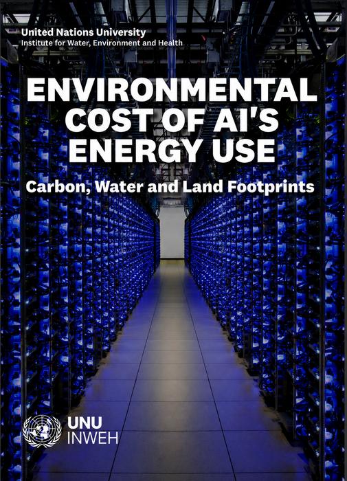
The report highlights a critical gap in how AI’s environmental impact is measured. Greenhouse gas emissions, particularly those linked to training large models, tend to be prioritised, but this approach overlooks other environmental costs. Solutions seen as “green” in one sense may worsen pressures in others, particularly in regions already facing resource scarcity. For example, switching to certain renewable energy sources may reduce carbon emissions but can significantly increase water consumption and land use.
AGRICULTURE
Soil Biological Health: A blind spot in India’s Agriculture Soil biological health remains a critical blind spot in Indian agriculture. Evidence shows degradation due to pesticides, monocropping, residue burning and excessive fertiliser use. Integrating biological indicators into national soil monitoring, scaling affordable tests and promoting agro-ecological practices vital. These can help restore productivity, cut emissions and improve nutritional security.
Andhra Pradesh natural farming programme wins 2026 Food Planet Prize Andhra Pradesh Community Managed Natural Farming (APCNF) has been awarded the 2026 Food Planet Prize—the world’s largest environmental award—for its role in leading one of the most ambitious transitions to agroecology ever undertaken. The prize, worth $1.5m, was presented in Båstad, Sweden, on June 2. Jury for global food systems award hails model that boosts soil health, cuts emissions and secures rural incomes. Over a million Indian farmers are moving to natural farming under the program.
MONSOON 2026
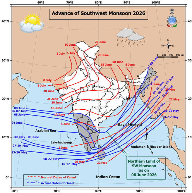
A new WMO El Niño/La Niña Update indicates an 80% likelihood of an El Niño event during June–August 2026. Probabilities for this to continue until at least November are near or above 90%. Although some uncertainty remains about El Niño peak strength and timing, most forecast models suggest it will be at least moderate – and possibly strong.
Delay in monsoon arrival Weather experts are highlighting an unusual calm in the Indian Ocean as one of the main reasons behind the slow progress. The Indian Ocean usually acts like a factory for monsoon weather. The ocean’s warm waters help create rain-bearing clouds and low-pressure systems that move northward into India. But right now, this factory is unusually idle.
Nearly 150 years ago, a prolonged monsoon failure triggered one of India’s worst famines which claimed at least 55 lakh lives. As scientists track changing ocean-atmosphere conditions, an uneasy question lingers: will the Super El Nino replay the script of the 1876-78 tragedy?
EDIT: History offers little comfort. Around 60% of El Niño years since 1951 have brought deficient or below-normal rains; 2002, 2009 were the severest droughts of the century with significant shortfalls in 2014 and 2015. With El Niño now near-certain through the heart of the season, the government must not count on a late, redeeming swing of the Indian Ocean Dipole. That means activating the Agriculture Ministry, Jal Shakti and Consumer Affairs Ministries on a war footing along with the disaster management authorities, with advisories steering farmers toward short-duration pulses, oilseeds and millets over thirsty paddy. Disciplined groundwater and reservoir management are necessary and crop insurance and relief provisioning must be readied. India will also have to brave more days of severe heat, which a parched landscape will only sharpen.
FLOOD 2026
WB CM announces joint strategy with DVC to tackle floods W Bengal Chief Minister on May 30 said that the Damodar Valley Corporation (DVC) and state irrigation and other related departments will work together during the upcoming peak monsoon season to combat the flood like situation in the low lying areas in the lower Damodar basin.
Pennar flowing ahead of SW Monsoon onset Significantly, Pennar River rises in Nandi Hills of Chikkaballapur in Karnataka. It enters AP near Parigi mandal and merges with the Kumudvathi River. The water then flows back into the Pavagada taluk of Karnataka before re-entering Andhra Pradesh in Kalyanadurg area. Incidentally, Pennar is only a streak of water even when there are heavy floods in the upstream Karnataka regions during peak rainy seasons. But on June 04, the river flushed with water, raising the spirits of farmers in the region.
Farmer Thippeswamy of Kalyanadurg expressed joy, saying Pennar River is flowing in peak summer season in the area. Further, the Dharmavaram Cheruvu, the historic reservoir originally built in the 12th Century, is about to overflow after receiving heavy flows from upstream regions. Irrigation officials say they have never seen the irrigation tank overflowing in the past few decades. The tank is just short of one-and-a-half feet of water before overflowing.
URBAN FLOODS
Bengaluru floods driven by urbanisation & poor drainage The report finds that Bengaluru’s recurring floods are largely caused by rapid concretisation, shrinking lakes, and poorly designed or encroached drainage systems rather than just heavy rainfall. Data shows that loss of wetlands and natural water channels has reduced the city’s ability to absorb and drain rainwater, while unplanned urban growth has increased runoff. Experts warn that without restoring lakes, protecting stormwater drains & regulating construction, flooding will remain a persistent crisis.
Velachery waterway project raises flooding concerns A proposed eco park project along a key stormwater passage in south Chennai has triggered opposition from residents, who argue that the initiative could intensify flooding the flood-prone urban corridors. The dispute in Velachery has once again highlighted the tension between beautification-led urban projects and the urgent need for climate-resilient drainage infrastructure across rapidly urbanising neighbourhoods.
CLOUD BURSTS
Chayang Tajo, villages devastated by flash flood Remote administrative headquarters Chayang Tajo in East Kameng district received incessant rains, causing massive flood and disruption of essential services, water supply line, and power lines in many areas. Surface communication was also snapped. It is reported that there was a cloudburst over Chayang Tajo and its adjoining villages on 4 June, which triggered the flash flood.
The flood has left a trail of destruction, as several paddy fields and standing crops were also reportedly damaged in the villages. Sources in Chayang Tajo informed that the 150 mm diameter main pipeline from the water treatment plant in Chayang Tajo was washed away. Various rural water supply structures (especially headworks/intake tank), including live water supply pipelines in Soshi Bagang, Namchar Bagang, Doripu Bagang, Laching Bagang, Rebe, and Killo villages were totally damaged, forcing the villagers to rely on rainwater from the roofs or nearby streams.
CLIMATE CRISIS
Tracing the collapse of a giant ancient Himalayan glacier The study reconstructs the glacial history of the eastern Himalayas using new exposure-age data from Arunachal Pradesh, showing that glaciers were much larger before ~45,000 years ago and retreated significantly after the Last Glacial Maximum (~20,000 years ago). By around 12,600 years ago, glaciers had shrunk to upper valleys and higher altitudes.
It finds that temperature was the primary driver of glacier changes, with warming triggering rapid retreat by increasing melting and shifting snowfall to rainfall, while colder conditions allowed glaciers to expand due to abundant monsoon moisture. The research highlights the strong sensitivity of monsoon-fed Himalayan glaciers to climate warming and fills a major gap in understanding past glacier dynamics in the region.
Azim Premji University warns of rapid climate risks along India’s coast The report Indian Coastal Region: Climate Projections 2021–2040 warns that India’s 11,000-km coastline is facing an accelerating climate crisis over the next 15 years, with rising temperatures, extreme rainfall, sea-level rise, coastal erosion, stronger cyclones, and growing threats to livelihoods and ecosystems.
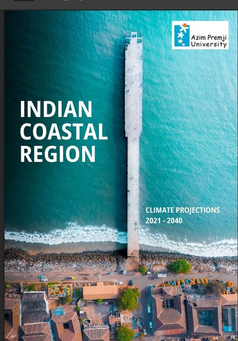
The report also highlights impacts on fishing, agriculture, salt production, public health, and water security, urging a shift from reactive responses to proactive climate adaptation and resilience planning.
SOUTH ASIA
Neutral Experts of Indus Water Treaty dispute appoints external specialist to check India’s Data The IWT Neutral Expert at The Hague has appointed French Agency ISL Ingenierie for the task of checking Indian data by March 2027 on the need for deep bottom gates to clear sediment of the existing Kishenganga and under construction Ratle projects.
India-Bangladesh ties face crucial test as Ganges treaty nears expiry Amid the numerous uncertainties in bilateral relations, the assumption of office by the new Indian High Commissioner in Dhaka may prove to be a silver lining in an otherwise overcast environment. While all indications suggest that the Ganges Water Treaty is likely to be renewed amicably, and even an interim agreement on the Teesta may be within reach, the larger and more consequential question remains: how does India envision its future engagement with Bangladesh? Bangladesh would be keen to turn a new page in the relationship, and India would do well not to overlook the importance of a neighbour whose cooperation can make a meaningful difference to the regional landscape. (Sreeradha Datta)
Teesta & India-Bangladesh Geopolitical Tensions A cooperative framework between India and Bangladesh could significantly improve flood management, ecological conservation, irrigation planning, disaster preparedness, and livelihood security for millions living across the basin. This could be achieved through measures such as regular hydrological data-sharing, coordinated flood forecasting systems, and joint river management initiatives that enable both countries to address shared environmental challenges collectively. More importantly, it could demonstrate how environmental cooperation can become a foundation for broader regional peacebuilding in South Asia.
Today, the future of the Teesta remains uncertain. The river can continue to become entangled within political delays and growing geopolitical competition, or it can emerge as a model for cooperative river governance between neighbouring countries facing shared environmental challenges. For the communities living along its banks, the outcome will shape far more than diplomacy alone. It will shape their security, stability, and hope for the future. (Kajol Gupta)
THE WORLD
Sediment rapidly filling reservoirs worldwide The Reservoirs around the world are losing storage capacity at an average rate of 7.3% per decade. The data comes from a study published in Nature Sustainability. In the study, led by Prof. Song Chunqiao of the Nanjing Institute of Geography and Limnology (NIGLAS) of the Chinese Academy of Sciences, the researchers developed the Global REservoir Inventory (GREI), combining remote sensing, geospatial data, and engineering records to identify more than 550,000 reservoirs worldwide. Over 95% of these reservoirs are smaller than one square kilometer. Reduced downstream sediment transport may also alter river morphology and intensify risks such as delta subsidence, coastal erosion, and ecosystem degradation.
Europe removes record number of dams in 2025 The 70 year old dam on Pcinja River, removed in North Macedonia was one of 603 obsolete river barriers, including dams, weirs and culverts, removed from European rivers in 2025, according to the 2025 Dam Removal Europe report.
It reconnected 3740 km of rivers. Since 2020, nearly 2,300 dams have been removed across Europe, mostly in Sweden, Finland and Spain. Iceland, along with North Macedonia, carried out its first removal in 2025. Iceland removed an old hydroelectric dam that was no longer in use. In 2024, the EU’s Nature Restoration Regulation set a target to restore at least 25,000 kilometers of rivers to a free-flowing state by 2030.
SANDRP
Also see: DRP 01 June 2026 & DRP 25 May 2026
Follow us on: www.facebook.com/sandrp.in; https://twitter.com/Indian_Rivers
