In an astounding move, NHPC published a Tender Notice for ‘Chenab-Beas Link Tunnel Project (Link 3)’ on the 20th May 2026 [1] and immediately cancelled it on the 23rd May 2026. No details of this project were online before this sudden announcement and its retraction, nor does the project have legally required environmental, forest, tribal ministry clearances or Gram Sabha resolutions in support.
And yet, Governor of Himachal Pradesh Kavinder Gupta stated, “Through Chenab-Beas link tunnel project, better utilization of water will be possible. Meeting requirements of states like Punjab, Haryana and Himachal Pradesh should be our first priority.” [2] So, even if the tender notice vanished within 72 hours, it seems that the government is supporting and will be pursuing the project. However, it has been noticed that the original tender is still in the active tenders list on the NHPC website.
But this might be one of the most disaster-prone regions in the Indian Himalayas for such a project,. It witnesses multiple risks which do not sit side by side, but routinely mix with each other, magnifying the impact of the disaster.
Without going into its strategic implications, let us look at the impacts of the proposed Chenab Beas Link within India, affecting thousands of Indian residents: many of whom are tribals from weak economic conditions and have been facing disproportionate brunt of climate change, climate disasters and irresponsibly planned infrastructure projects. Himachal Pradesh, Uttarakhand and Jammu and Kashmir have been facing steep rise in water-related disasters. 2025 Monsoon claimed more than 520 lives in floods, landslides, mudslips and related incidents in Himachal Pradesh and Jammu alone.[3] Any infrastructure project in the region has to consider and respond to this stark reality. It will also be held accountable if it fails to do so.
Project components
19 meters high concrete barrage and stilling basin built atop deep upstream plastic concrete cutoff trench, fortified bank-side power intake structures.
8.7-kilometer water diversion tunnel bored through the Pir Panjal Range, supported during construction by horizontal access adits that will later be sealed with permanent concrete adit plugs.
A concrete outfall structure designed to discharge the high-velocity flow into the Beas basin, regulated by interconnected hydro-mechanical works including radial gates, vertical lift gates, and automated hoisting mechanisms.
Project Location
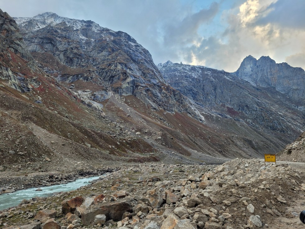
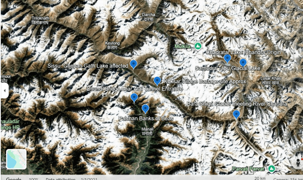
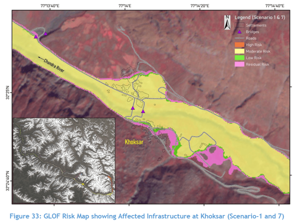
Barrage: Koksar village in Lahaul and Spiti on the banks of River Chandra, elevation of 3140 mts (10,300 feet).
Tunnel: Through Pir Panjal Himalayas, close to the existing Atal Tunnel at Rohtang Pass.
Outfall: In Beas basin, possibly near Dhundi, Palchan or Solang near the headwaters of Beas.
Possibly the worst place to build a barrage and tunnel?
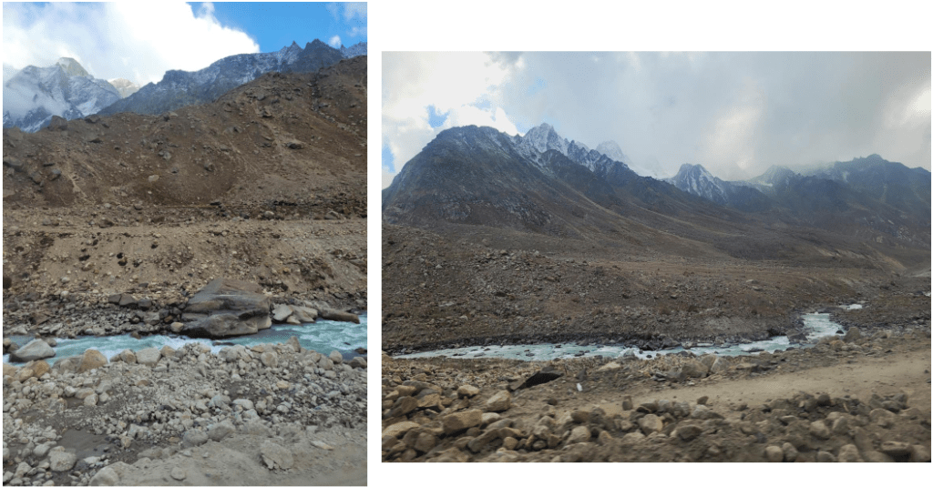
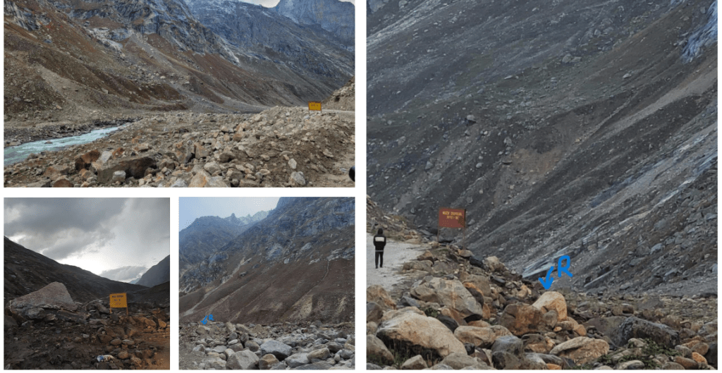
This entire region is vulnerable from multiple directions and has been facing unprecedented climate disasters in the recent years. What follows is a brief snapshot of the project area, based on site visits and interviews. For detailed references, refer to our interactive report on Climate Change in Chenab Basin.[4]
Chandra River: 33% ice loss by 2050s
Koksar village, where the barrage is to be located falls in the headwater region of the Chandra River, one of the two major tributaries of River Chenab in Lahaul Spiti district, Himachal Pradesh. Koksar is about 65 kms downstream from Chandratal (origin of river Chandra at 14900 feet elevation), about 67 kms from Samudra Tapu Glacial Lake which poses a GLOF risk and about 65 kms downstream from Bara Shigri Glacier, the largest glacier in Himachal Pradesh.
Even in a moderate emission mitigation scenario, Chandra basin is projected to lose 33% of its ice volume by the 2050s. That is a loss of 17.7 Giga Tonnes of Ice[5], which will have a direct implication on future water diversions through the Chenab Beas Link.
Chandra basin (area of 2,440 sq km) has around 200 glaciers and 23 small villages and studies predict that in response to the projected climate, the basin is likely to retain only 40 to 50% of its glacial area by the end of the century. “Corresponding volumes of glacier water retained are much lower at 40% and 29% but the volume loss could be as high as 97% for low altitude glaciers.” [6]
From 2000 to 2014, the total number of glacial lakes in Chandra basin (larger than 2000 sq mts) increased from 28 to 46 and their area expanded from 1.91 sq km to 3.26 sq km [7]The accelerated growth of glacial lakes has resulted in increased hazard and damage potential of glacial lake outburst floods. And scientists single out that ‘GLOF is an emerging threat in Chandra basin.’[8]
Samudra Tapu: A 905% expanded glacial lake upstream the barrage site
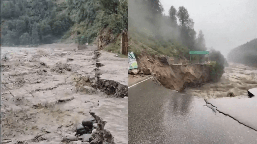
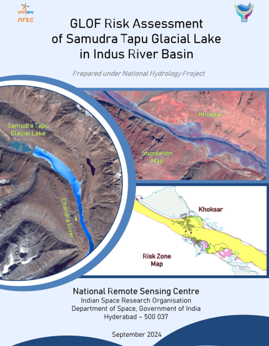
A few kilometers downstream of Chandratal and 67 kms upstream from Koksar is the Samudra Tapu glacier which terminates into the Samudra Tapu Glacial Lake. This lake has been expanding significantly during the past decades with studies warning about the possible GLOF. India’s premier remote sensing institute, the National Remote Sensing Centre under the aegis of Indian Space Research Organization (ISRO), in its 2024 report on Samudra Tapu Glacial Lake states, “Analysis in 1965 and 2022 satellite imagery revealed a 905% increase in size from 14.19 ha to 142.69 ha. Such alarming rate of lake expansion and the rapid growth of its downstream settlements have increased the possibilities of a catastrophic impact due to GLOF event by many folds.”[9]

The front page of this report has the image of Koksar being inundated after a GLOF from Samudra Tapu Lake. See below.
Bara Shigri: Himachal’s largest glacier, rapidly retreating upstream the barrage site
About 65 kms upstream of the barrage site is Bara Shigri, the largest glacier in Himachal Pradesh (28 km long, 3 km wide with 131 sq kms in area) which is receding rapidly and has lost about 4 sq kms area in the last century. According to the IPCC’s Fourth Assessment Report, Bara Shigri’s snout shows a retreat of 650 meters between 1977 to 1995, averaging 36.1 meters retreat annually.
More than 60 ice-dammed glacial lakes have formed on the debris covering the glacier. These lakes are volatile and highly susceptible to climatic changes. Bara Shigri dammed the Chandra River in 1836 and the resultant lake burst eventually, causing havoc downstream.
Ghepan Gath Glacial Lake: “We are sitting on a GLOF!“
About 12 kms downstream of the barrage site at Koksar is Sissu village which lies in the shadow of Ghepan Gath Glacial Lake: one of the most dangerous glacial lakes in India. The lake, at an elevation of 4068 masl, joins Chandra through Sissu Nalla. This point is about 5.3 kms downstream Atal Tunnel North Portal and 12 kms downstream Koksar. In November 2025, Lahaul Spiti Deputy Commissioner said, “We are sitting on a GLOF.”[10]
NRSC-ISRO report on Ghepan Gath Lake[11] states: “1989 and 2022 imagery revealed a 178% increase in size from 36.49 ha to 101.30 ha. Such alarming rate of lake expansion has increased the possibilities of a catastrophic impact due to a GLOF event by many folds.” Studies indicate that the lake will double its size in the near future and poses a very serious GLOF risk and threat to life and property to the downstream village of Sissu, its river camping grounds and tourist accommodations. “Sissu is potentially exposed to high-intensity glacial lake outburst flood hazard under all current scenarios and the moderate and large magnitude future scenarios.” One month back, the NDMA was planning to install an Early Warning System here.[12]

It is exceedingly clear that the upstream and immediate downstream of the proposed barrage is an extremely vulnerable region under the shadow of serious GLOF, flash flood, avalanche or landslide risks. There is no operational early warning system, no climate assessment, no emergency plans for this region so far. The impacts of an additional barrage, blasting and tunneling and muck disposal here is incomprehensible. The only reasonable connection of this region with the mainland is through the Atal Tunnel which gets closed multiple times in inclement conditions.
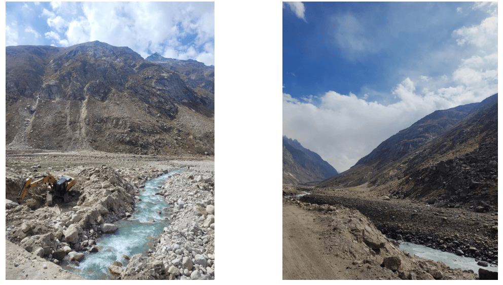
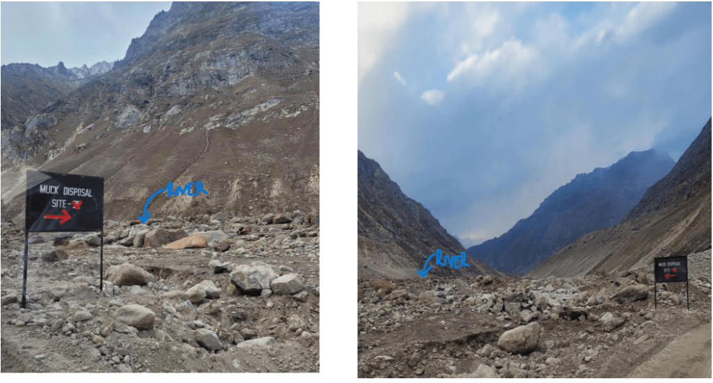
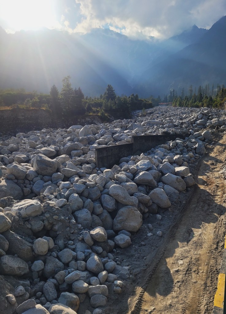
Muck dumping inside Chandra River: A choked, flashy river upstream the barrage
Massive amounts of muck from road construction have been dumped inside the Chandra River along the NH 505 Gramphu to Kunzum Pass at an altitude higher than 10,000 feet. Koksar is about 10 kms downstream Gramphu, from where dumping begins. In most places, no retaining walls contain this muck, and the existing walls have been broken. The extent of muck is immense and there is a realistic possibility that a high energy flash flood or GLOF will operationalize it, devastating the downstream. This muck can block the barrage entirely, creating a reservoir which will eventually break. This is like what happened in Madhopur Barrage on Ravi last monsoon.
Drilling for the Atal Tunnel had created immense amounts of muck, exacerbating flood impacts in Palchan and Solang in the neighboring Beas basin. [13]
Landslides and avalanches in the region: Disturbing persistence of disasters
The headwaters of Chandra, and especially the region near Koksar and Sissu, have been experiencing serious flash floods, landslides and avalanches in recent years. The incidents have been recurring consistently since 2022. Find a list attached in the Endnotes. [i]
Drilling and blasting inside Pir Panjal, close to Atal Tunnel
NHPC tender states that the project duration is about 4 years, however the Atal Tunnel project in the same region took 10 years [14]and its estimated cost rose from 500 Crore to 3200 Crore in 2020[15]. The project needed extremely careful construction and tunnel drilling by the Border Roads Organization and specialized contractors. It hit a geological surprise by way of the Seri Nallah Fault Zone which took several years to resolve[16]. It also faced the problem of dumping more than 800,000 cubic meters of muck. Valleys in Chandra and Beas are narrow and already full of muck and solid waste. Where will the muck go?
An average of 5,000 vehicles cross the Atal Tunnel daily. Drilling and blasting close to an existing tunnel in a vulnerable region and high seismic zone is extremely risky to the tunnel and tourists.
Disasters in Beas Headwaters: Highway washed off, bridges collapsed
The headwaters of Beas where the tunnel outfall will be located (in the ten-kilometer zone between Dhundi, Palchan or Solang) have been facing unprecedented flash floods and avalanches in recent years. Monsoon of 2025 saw the destruction of Leh-Manali highway in this stretch, cutting off access to the Atal Tunnel for months. Palchan and Solang suffered heavy losses due to the washing away of roads, bridges, tourist infrastructure and camps. The destruction is still there to see.
In July 2023, massive flash floods in Beas washed away the Palchan bridge as well as the Leh-Manali highway, stranding thousands of tourists on the road. One cannot imagine the impact of additional water coming from Chenab into this disaster-prone region. Channel of Beas here is raised and strewn with huge boulders brought down by the recent floods.
Changing precipitation profile of Lahaul: Water transfer during floods?
Lahaul is a high-altitude desert with low rainfall where snowmelt in spring and early summer forms an important part of the river flow. However, several studies including Himachal State Action Plan for Climate Change[17] note a significant departure from precipitation patterns and a sharp rise in summer rainfall in the months of June, July and August. Several places in Chandrabhaga basin have been flooding in the past monsoons. This is also the time when the Beas is in floods. So, how will the water transfer help Beas? Additionally, the rainfall further increases landslide risks. “The increase in rainfall can lead to a higher incidence of mudflows, landslides, floods, and other related events, as the region is made up of sedimentary rocks.”[18]
Where will the water go?
Even if we consider that water is transferred from Chenab to Beas, where will it go? Major dams in the Beas-Sutlej system like Pandoh, [19]Pong and Bhakra are stifling with silt and have lost over 1/4th of their storage capacity already. While the BBMB has floated tenders for desilting, there are no interested parties to do this job. [20]There is no land to dump the massive, excavated silt either. The downstream conveyance system is equally over stretched and in need of urgent refurbishment. Where will this water from the Chenab Basin go?
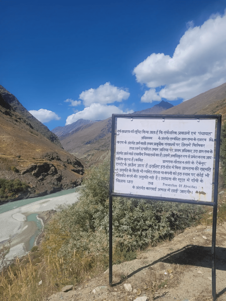
Strong local opposition: “No dams, No surveys”
Tribals of the Lahaul Spiti region have been facing repeated impacts of climate disasters. They have been up in arms against hydropower projects, blasting and tunneling in this region for decades. They have again strongly opposed this project proposal[21], underlining the very real and serious safety concerns as hydropower projects and their tunnels projects have created havoc in Himachal, especially in the Kinnaur, Sainj, Parbati, Beas and Ravi valleys. The locals are entirely justified, hence, in raising legitimate concerns.
Considering all these issues, one hopes that the Chenab-Beas Tunnel Link project announcement was a mistake and it remains that way. It is incomprehensible that such a project will be pushed in this extremely vulnerable region without proper studies.
While there might be strategic considerations, it is the safety of thousands of Indians and future of the Indian Himalayan region that is at stake here.
Parineeta Dandekar, SANDRP (parineeta.dandekar@gmail.com)
End Notes:
[i] July 2022: A sudden cloudburst over the high-altitude catchments of Lahaul triggered a flash flood in a local tributary nallah near Koksar, dumping debris on the Manali-Leh national highway and temporarily suspending traffic. (Reference: Himachal Pradesh State Disaster Management Authority – HPSDMA Monsoon Report
January 2023: A massive winter avalanche slid down the steep slopes near the North Portal of the Atal Tunnel close to Sissu, burying a stretch of the highway under several feet of snow and forcing an extended road closure. (Reference: Border Roads Organisation – BRO Operational Logs)
July 2023: Historical, unprecedented monsoon rainfall combined with a Western Disturbance caused severe bank erosion, flash floods, and debris flows across multiple nallahs in Koksar and Sissu, severely damaging local camping sites and public property. (Reference: National Disaster Management Authority – NDMA Post-Disaster Needs Assessment)
August 2023: Accelerated land subsidence and intense slope failures accelerated beneath the villages of the upper Chandra basin, leaving extensive structural cracks in residential homes and agricultural fields. (Reference: State Centre on Climate Change, Himachal Pradesh Landslide Inventory)
March 2024: Fresh, heavy high-altitude snowfall triggered a series of active snow avalanches around Koksar, making the highway highly unstable and restricting all non-essential vehicular movement. (Reference: Kullu-Lahaul District Administration Advisory)
April 2024: A massive snow avalanche slammed directly into the Chandrabhaga (Chandra) River channel near the North Portal of the Atal Tunnel, temporarily blocking the natural river flow and causing a sudden, hazardous water level spike stretching down to Sissu. (Reference: Himachal Guardian, “Avalanche blocks flow of Chandrabhaga river in Lahaul”)
July 2025: Continuous, heavy cloudburst events caused a sudden flash flood down the volatile Pagal Nala stream just before Sissu, washing away sections of the underlying road bed and completely snapping the highway connection. (Reference: Discover Kullu Manali Highway Tracker Logs)
August 2025: Intense, raging waters of the Chandra River heavily undercut the mountain toe slopes near Sissu, leading to major landslides that blocked the main arterial highway at multiple points including Dhundi and Samahan. (Reference: Himdhara Environmental Collective, “Himachal’s Monsoon Disasters Report”)
January 2026: Successive, severe winter blizzards triggered multiple localized snowslips and dangerous black ice formations on the roads connecting Koksar and Sissu, stranding thousands of tourist vehicles over long weekends. (Reference: Lahaul-Spiti District Police Control Room Logs)
[1] Tender ID: 2026_NHPC_909085_1
[2] https://www.aninews.in/news/national/general-news/chenab-beas-link-tunnel-project-will-benefit-india-nations-water-must-first-serve-indian-states-himachal-governor20260601164037/
[3] https://www.awazthevoice.in/india-news/dead-nearly-structures-damaged-in-rain-disaster-in-j-k-52607.html, https://www.business-standard.com/india-news/himachal-monsoon-2025-claims-386-lives-causes-4-465-crore-losses-sdma-125091201684_1.html
[4] https://storymaps.arcgis.com/stories/ba82aadda7114d5b862fc8c48c1ad56b
[5] Tawde et al, 2019. An assessment of climate change impacts on glacier mass balance and geometry in the Chandra Basin, Western Himalaya for the 21st century, 2019, Environmental Research Communications. https://iopscience.iop.org/article/10.1088/2515-7620/ab1d6d
[6] Tawde et al, 2019. An assessment of climate change impacts on glacier mass balance and geometry in the Chandra Basin, Western Himalaya for the 21st century, 2019, Environmental Research Communications. https://iopscience.iop.org/article/10.1088/2515-7620/ab1d6d
[7] Chander Prakash et al, 2018. Glacial lake changes and outburst flood hazard in Chandra basin, North-Western Indian Himalaya, https://doi.org/10.1080/19475705.2018.1445663
[8] Chander Prakash et al, 2018. Glacial lake changes and outburst flood hazard in Chandra basin, North-Western Indian Himalaya, https://doi.org/10.1080/19475705.2018.1445663
[9] https://bhuvan.nrsc.gov.in/nhpfs/pdf/NRSC_SamudraTapuGlacialLake_GLOF_Risk_Assessment_Report.pdf
[10] https://timesofindia.indiatimes.com/city/chandigarh/alarm-over-expanding-glacial-lake-in-lahaul-spiti-risk-level-critical/articleshow/125172831.cms
[11] https://bhuvan.nrsc.gov.in/nhpfs/pdf/NRSC_GhepangGhatGlacialLake_GLOF_Risk_Assessment_Report.pdf
[12] https://www.etvbharat.com/en/bharat/himachal-pradesh-the-ndma-team-inspected-the-expanding-ghepan-lake-in-lahaul-spiti-to-assess-flood-risks-from-melting-glaciers-himachal-pradesh-is-now-installing-its-first-early-warning-system-there-to-provide-advance-alerts-for-potential-disasters-enn26041603288
[13] https://scroll.in/article/1071853/how-construction-muck-worsens-flood-damage-in-himachal
[14] https://www.team-bhp.com/forum/street-experiences/227141-atal-tunnel-worlds-longest-highway-tunnel-above-10-000-ft-now-ready.html
[15] https://www.pib.gov.in/PressReleasePage.aspx?PRID=1661260®=3&lang=2
[16] https://www.smec.com/brn/project/atal-tunnel/
[17] https://www.frontiersin.org/journals/climate/articles/10.3389/fclim.2024.1348132/full
[18] https://www.frontiersin.org/journals/climate/articles/10.3389/fclim.2024.1348132/full
[19] https://link.springer.com/article/10.1007/s11269-024-04021-5
[20] https://www.hindustantimes.com/cities/delhi-news/more-rain-expected-in-delhi-max-temp-likely-to-be-below-40-c-this-week-101780289771426.html
[21] https://www.tribuneindia.com/news/himachal/lahaul-group-opposes-chenab-beas-tunnel-project/
