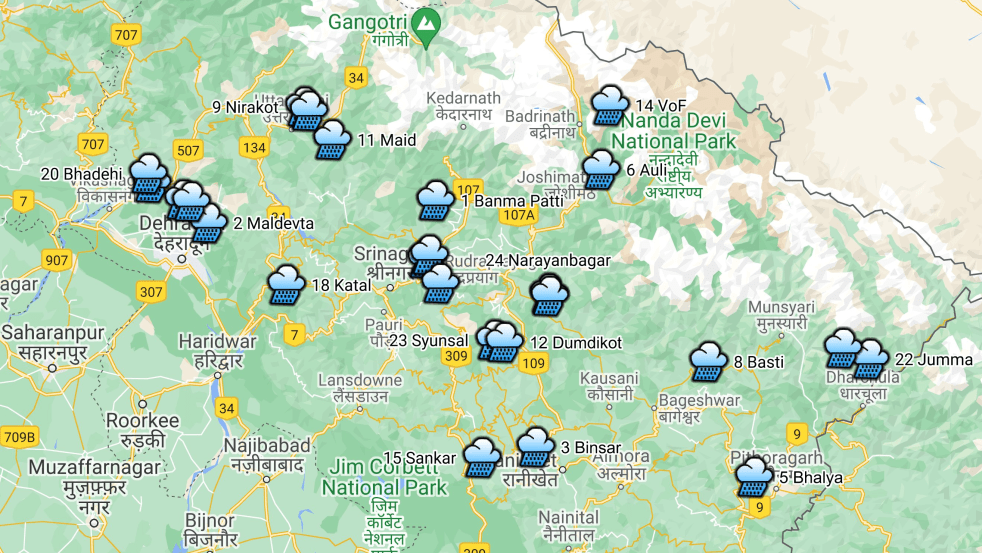
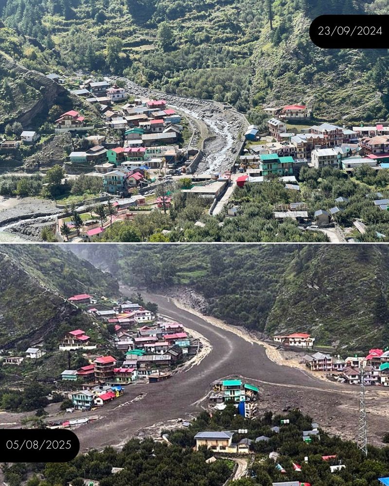
(Feature image: Bar Chart showing number of Level Forecast/Monitoring, Inflow Forecast sites in North Indian States & UTs)
Continuing analysis of Central Water Commission’s flood forecast website, SANDRP presents the details of flood monitoring sites in North Indian states comprising Union Territories of Jammu & Kashmir, Ladakh, Chandigarh, Delhi and states of Himachal Pradesh, Uttarakhand, Punjab, Haryana and Uttar Pradesh. Before this, we have prepared similar critical reports and highlighted problematic issues in flood monitoring sites in North India in 2018, 2019 and 2020.
SANDRP has been compiling the extreme rainfall events termed as cloud bursts occurring during monsoon season in Himalayan states. This account brings out the status of such incidents in the state of Uttarakhand. We have already published details of at least 24 ‘cloud burst’[i] incidents in pre monsoon month of May 2021 in the state. In following parts, we would cover the other states in Western Himalaya.
Flood forecasting is an important activity during monsoon, considering the huge and increasing flood prone area, flood frequency, intensity and flood damages. Accurate and timely flood forecasting can hugely help reduce the damages due to floods. Central Water Commission (CWC) is the only agency responsible for flood forecasting in India. To understand the CWC’s flood forecasting better, we have compiled the list of the various flood, inflow forecasting sites and flood monitoring sites in India.
In this compilation, we have given state wise list of CWC’s level forecasting, flood monitoring and inflow forecasting sites in North India, comprising of Union Territories Jammu & Kashmir, Ladakh, Chandigarh, Delhi and states of Himachal Pradesh, Uttarakhand, Punjab, Haryana and Uttar Pradesh. It includes available details like name of river, sub basin, Warning level (WL), Danger Level (DL), High Flood Level (HFL), Full Reservoir Level (FRL), Maximum Water Level (MWL), as applicable. As we see below, there are many gaps in this basic information for the sites that are part of CWC’s list. A similar zonewise overview of CWC’s sites was compiled in 2018 and 2019, which can be seen here: Overview of CWC Flood Forecasting Sites 2018: North India; Overview of CWC Flood Forecasting Sites 2019: North India. We have brought this updated compilation for 2020 as there are large number of changes.
We have presented through separate articles, overview of sand mining issues of Punjab, Uttar Pradesh, Madhya Pradesh, Rajasthan, Gujarat, Maharashtra, Tamil Nadu, Karnataka, Kerala, Telangana-Andhra Pradesh, East India and North East India, in addition to one on murders, violence, threats and infrastructure damages due to illegal sand mining. This compilation tries to throw some light on the sand mining related issue of 2018 in remaining states with the help available media reports.
There is no debating that Ganga must flow free or will perish with all attendant consequences. This is vindicated by Ravi Chopra Committee in its report to the Supreme Court submitting that there has been an increase in disasters in Uttarakhand ever since the tragedy in 2013, due to the presence of big dams. The Union of India under your governments pledged to rejuvenate the Ganga including Alaknanda, Mandakini and Bhagirathi and all their tributaries.
Presently, four under-construction dams namely Tapovan-Vishnugad, Vishnugad-Pipalkoti, Singoli-Bhatwari and Phata-Byung are further threatening the survival of this river adding to the damage already done by the existing dams.
To save the River Ganga, Swami Saanand fasted for 111 days to draw your attention to River Ganga’s cries for survival before he succumbed unheeded. Carrying on the baton, Sant Gopaldas fasted for 146 days when he disappeared under suspicious circumstances unheard and unheeded. Presently the 26 year old young Brahmachari Aatmabodhanand from Matri Sadan, Haridwar, has been on a fast since 24th of October 2018 determined to carry on the baton for a positive response on Ganga from your governments.
The Char Dham All Weather Road Project has been approved by National Green Tribunal (NGT) on September 26, 2018. The controversial project has evoked several environmental concerns right from the inception stage.
Almost more than one and half year into the unmindful implementation of the project, the risks and fears associated with the project are clearly visible throughout the construction route. In last few months, several independent reports have also raised serious concerns over the haphazard manner in which the project is being executed through sensitive hilly terrain.Continue reading “Char Dham Highway Project: An overview”→
Above: The Bhagirathi valley has a lot of beautiful bends, comparable to the most popular scenic spots across the world. But we’re busy cutting down the mountain to make broader roads in these eco-sensitive areas. Image taken in March 2017. Photo credits: Siddharth Agarwal
Guest Blog by Siddharth Agarwal
In the initial stages of planning the Moving Upstream project on the Ganga for Veditum, where we were going to walk along the whole length of the river, I had approached a lot of individuals to learn from their experiences about the river and the many connected stories around it. These learnings varied from science and activism to adventure and survival. Of all those who were approached, Himanshu Thakkar from SANDRP had been the most generous in extending knowledge resources and sharing contacts from the field. He even entertained a couple of my visits to their office and shared with me a copy of the SANDRP report prepared by Theo, called Headwater Extinctions (February 2014, see: https://sandrp.wordpress.com/2014/12/16/new-publication-headwater-extinctions-impact-of-hydropower-projects-on-fish-and-river-ecosystems-in-upper-ganga-and-beas-basins/, it includes link to full report), along with a few other documents.
Headwater Extinctions looks at the role played by small and large hydropower projects in altering the fish biodiversity and river ecosystems in the Himalayan reaches of the Ganga and Beas basins. It also speaks about the perspective of local people and that of the authorities towards hydropower projects. Theo, who is an adventurer and ecologist, penned down the report with a scientific aptitude, while I will limit myself here in this revisit report to updated observations made on ground while walking along the Ganga in Uttarakhand (March 2017). This comparative observation will hopefully enable a conversation that requires continuity. Continue reading “Walking along Ganga in Uttarakhand in 2017”→
Geographical Location-North India largely mountainous with two plains and two partly mountain districts in the south; Area- 53483 sqkm; Population- 10.12 million; River basins- 4 River basins (R. Ganga‘s basin is subdivided in the map below into R. Bhagirathi, R, Alaknanda and R. Ganga sub-basins); Districts-13; Climate- Sub-tropical to tundra
About Uttarakhand Rivers
The water quality of Uttarakhand‘s rivers is basically good, especially in the upper reaches. Downstream of some large settlements and in the lower reaches in the Himalayan foot hills the water quality suffers due to the release of untreated sewage and industrial effluents. But the state‘s ambitious program to build 450 hydro power projects threatens the survival of the river ecosystems and the lives and livelihoods of people who live in these river valleys.
Above: Parshuram Kund on River Lohit, Arunachal Pradesh
Since 2005, last Sunday of every September is celebrated as the World Rivers Day. The tradition started in 1980s in British Columbia when some river activists came together for their rivers. Its only grown since then.
All through the year we hear about water conflicts, river pollution, degrading freshwater biodiversity, damming of living rivers, mismanagment, concretisation and encroachment on Indian Rivers. As I write this, Cauvery Water Conflict and simmering, serious discontent over the Indus Water Treaty governing 6 rivers between India and Pakistan is mounting. A simple google search on Indian Rivers throws up images of filth, pollution, droughts and floods. Lest we forget, thats not the whole picture. We are still the custodians of an amazing legacy. India still holds some of the most beautiful, healthy and life giving rivers in the world. There are people and communities nurturing their rivers and protecting them. All is not lost and this is a battle worth fighting, full of positive energy.Continue reading “Celebrating our Rivers on the World Rivers Day, 2016!”→
SANDRP has just published a new report: “Headwater Extinctions- Hydropower projects in the Himalayan reaches of the Ganga and the Beas: A closer look at impacts on fish and river ecosystems”, authored by Emmanuel Theophilus. The report[i] was released at the India Rivers Week held during Nov 24-27, 2014.
Front Cover of the report HEADWATER EXTINCTIONS
Headwater Extinctions deals with impacts of hydropower projects in Beas basin in Himachal Pradesh and Alaknanda-Bhagirathi basins in Uttarakhand on river ecosystem and its components, mainly fish. While the harrowing impacts of hydropower projects on local livelihoods and social systems are being realized gradually, we are yet unclear about the extent of impacts of these so-called green projects have on fish and aquatic biodiversity.
Environmental Impact Assessments of large hydropower projects (> 25 MW as per EIA Notification 2006[2]) are supposed to assess ecological impacts of such projects, but we are yet to come across any comprehensive effort in this direction from EIA reports that we have assessed so far.
The Expert Appraisal Committee (EAC) of Union Ministry of Environment, Forests and Climate Change (MoEF & CC) which is entrusted with appraising these projects and their EIAs has paid very little attention to this issue. Since over a decade, the EAC has had expert members from Wildlife Institute of India (WII) and Central Inland Fisheries Research Institute (CIFRI). Both these institutes are supposed to have expertise on fish and aquatic biodiversity. But sadly, their presence has not helped fill the serious lacunae in appraisal and EIAs of the hydropower projects.
SANDRP had been trying to highlight the impact of hydropower on fish and the long standing problems in the so-called mitigation measures being recommended by the EAC. We thought that it may be useful to bring out a first-hand report bring out ground realities of what is happening to our rivers. Emmanuel Theophilus, based in the Dhauliganga Valley and who is an avid mountaineer, storyteller, ecologist and our ally was commissioned by SANDRP to study the impacts of hydropower on fish and ecosystems, review the EIAs as well as mitigation measures recommended by EAC as a part of Environment Management Plans of hydropower projects. We are very glad to publish the report as a first of the hopefully many steps to be taken to understand and address this important issue.
Headwater Extinctions has been written in an eminently readable style that Theo is known for, as could be seen from the earlier blogs[3] he wrote for us! The report has a section on ‘Travelogue’ which records Theo’s travels and thoughts as he visits Bhagirathi and Alaknanda sub basins in Uttarakhand and Beas basin in Himachal Pradesh. The report also brings illuminating photos from these trips. The fact that the travels happened within months of the Uttarakhand disaster of June 2013 could be seen in his photos and travel reports. It further substantives the role hydropower projects played in increasing the proportions of the disaster.
Travelogue is followed by discussions in two parts: Discussions on the impact of hydropower projects on fish and aquatic habitats along the two sub-basins and the role of EIAs, EMPs, Fisheries Plan and the government approval process. The findings of this report are valid for all Himalayan states & rivers.
Back Cover of the report HEADWATER EXTINCTIONS
Headwater Extinctions ends with some striking insights. Sample this: “We are in the midst of river extinctions in the Himalaya, but are surrounded by a tragic drama of double-speak and equivocation. And a horde of jostling brokers. Ranging from reputed universities, government departments, research institutions, everyday bureaucrats, and of course, politicians and contractors from within ‘the community’[4] along the developers and regulators. They not only write the script of this drama, they even play all the part”.
The inside covers of the report have detailed maps of the two basins with locations of hydropower projects, with annexures containing lists of hydropower projects in Upper Ganga and Beas basins and also list of fish found in Upper Ganga basin.
Theo has completed this report on a stringent timeline and budget, which meant that all the proposed and implemented fisheries management plans could not be assessed. We hope Headwater Extinctions provides sufficient material and compelling reasons to overhaul the way impacts of hydropower projects on fisheries and aquatic biodiversity are treated by EIAs, EMPs and government committees. We would also urge agencies like WII and CIFRI to do justice to their work inside EAC and beyond. That they are not doing that is apparent.
For EAC and MoEF&CC, we certainly would like them to ensure proper and full impact assessment of projects on aquatic biodiversity in the EIAs. The EAC also needs to stop approving completely ineffective fish hatcheries. They could initiate a credible independent study of the costs, benefits and performance of the fisheries development plans they have been approving in recent projects. It does not only smell fishy, but more like a scam! Here is a relevant quote from the report: “I can’t help see a few things here, as perhaps you do? Bluntly put, I see slush funds being dangled to a whole range of possible collaborators. The kindest term I can find for them is ‘brokers’.”
We look forward to your comments and suggestions on all aspects of Headwater Extinctions. If you would like a hard copy, please write to us.
[2] We have been saying this for long and this report helps substantiate our contention that the assumption that projects below 25 MW are benign and do not need EIA-EMP or environmental monitoring and public consultations is wrong.