
About Madhya Pradesh
The state of Madhya Pradesh (MP) was bifurcated in the year 2000. The total area of MP state is 3,08,245 sq. km. The state has been divided into 50 districts and 342 sub districts. The total human population of the state is 725.97 million. (2011 census) with a decadal growth rate of 20.3%. Key centres of growth are around the urban centres of Gwalior, Indore, Bhopal and Jabalpur.
Climate
It has a subtropical climate. Hot dry summer extends from April to June followed by monsoon from July to September and winter months (November to February) are cool and relatively dry. The average rainfall is about 1,370 mm and it decreases from east to west. Summer mean maximum temperature rises to about 42.5 deg C in northern parts and the average temperature during winters is as low as 10 Deg C again in the north while it varies from 10 – 15 deg C in the south. (Source: Gosain et al in Climate Change in Madhya Pradesh: A Compendium of Expert Views – II)

Physiographic conditions
Madhya Pradesh consists largely of a plateau streaked with the hill ranges of the Vindhyas and the Satpuras with the Chattisgarh plains to the east. For the sake of convenience Madhya Pradesh is divided into 7 Physiographic divisions which are mentioned below:
- Malwa Plateau
- Plateau of Madhya Bharat
- Bundelkhand Plateau
- Rewa Panna Plateau
- Narmada-Son valley
- Satpura Maikal Range
- Baghelkhand Plateau
With the Vindhyachal and Satpuda ranges stretching through, almost the entire land mass of the state with few exceptions (lashkar plain in north, Narmada valley in south west and patches in north west) lay on a number of plateaus and hills (Kanjarda, Sondwara, Umatwara, Shivpuri, Sagar, Rewa, Chindwara and Betul Plateau and Barwani hills). Resultantly number of rivers originates from these uplands draining ultimately into neighboring states.
West flowing river Narmada (in association with the north and north east flowing river Son) utilizes the rift valley between the Vindhyan and the Satpuda range to bifurcate the state into north – south halves. Tapi, another west flowing river, with small catchment in the state also flows in a rift valley. This is explained below.
Forests
Forests cover around 95,221 sq kms area of the state. This area has been classified into ‘Reserved Forest’, ‘Protected Forest’ and ‘Unclassified Forest’. Variability in climatic conditions brings about significant difference in the forest types of the state. There are four important types of forests namely Tropical Moist, Tropical Dry, Tropical Thorn, and Subtropical broadleaved Hill forests. The forest area can also be classified on the basis of composition of forest terrains. Based on composition, there are three important forest formations namely Teak forest, Sal forest and miscellaneous Forests. Bamboo bearing areas are widely distributed in the state of Madhya Pradesh.
Central, southern and eastern parts of Madhya Pradesh are rich in forests, while western and northern parts are comparatively deficient in forest.
Forests play a crucial role as river nurseries (most origins lay there) and house of springs that feed the rivers, the year round. The health of springs is key to river base flows in lean season, since devoid of high hills and glacial melt (as is true in the case of Himalayan rivers), rivers are fed by their forested catchments.
Groundwater
Madhya Pradesh has diverse hydrogeological characteristics resulting into varied water potential at different places. More than 80% of the total land area of the state is covered by variety of hard rocks varying in geological structures, geomorphological set up and hydro meteorological conditions.
More than 90% of the rural and 50% of Urban population is dependent on ground water sources in the state. Ground water is being the major source of irrigation. According to ground water report submitted in 2013 about 6,714,300 hectare of land is irrigated through ground water. There are reports about declining Ground water levels throughout the state. Ground water has also proved to be an important resource to meet the rapidly expanding demand of drinking water.
It is well known that the flowing rivers contribute significantly to ground water recharge through their associated aquifers.
About Madhya Pradesh Rivers
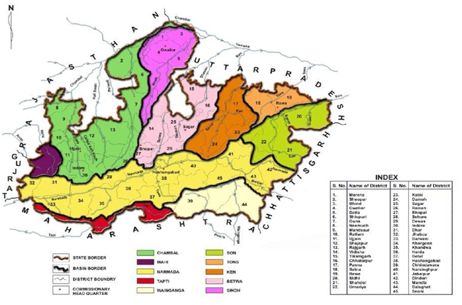
Map & Table of Major River Basins in Madhya Pradesh
The drainage map of the state indicates streams spread over almost the entire land surface of the state. Centrality and topography of the state results in rivers originating from within the state but draining out into the neighbouring states.
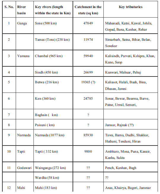
Ganga, Godavari, Tapti, Narmada and Mahi are the major river basins fed by the state. The State is further divided in to ten river sub basins. These are: 1) Chambal; 2) Sindh; 3) Betwa; 4) Ken; 5) Tons (Tamsa); 6) Son; 7) Narmada; 8) Wainganga; 9) Tapti; and 10) Mahi.
The northern part of the state drains largely into the Ganga basin and the southern part into the Godavari and Tapti (Tapi) system. The Narmada, Tapi and Mahi rivers flow from east to west. The Vindhyas form the southern boundary of the Ganga Basin, with the western part of the basin draining into the Yamuna and the eastern part directly into the Ganga itself. All the rivers, which drain into the Ganga basin flow from south to north, with the Chambal, Shipra, Kali Sindh, Parbati, Kuno, Sind, Betwa, Dhasan and Ken rivers being the main tributaries of the Yamuna, joining the Ganga. While Tons and
Son which originate in the state join directly the Ganga. The Son is of great significance in that it is the largest tributary going into the Ganga from the south bank and arising out of the hills of Madhya Pradesh rather than from the Himalayas. (Source: Gosain et al in Climate Change in Madhya Pradesh: A Compendium of Expert Views – II ).
The Wainganga, the Wardha, the Pench, the Kanhan and Penganga rivers, discharge their waters into the Godavari system.
Polluted River Stretches

Industrialisation is often associated with an increase in the pollution load onto water bodies including rivers. The pace of industrialization in the state is slowly but steadly rising. The key industrial centres in the state are in and around the cities of Indore-Ujjain, Ratlam, Mandsaur, Neemach, Bhopal, Gwalior, Morena, Sagar, Jabalpur and Satna.
The rivers in Madhya Pradesh are monitored by CPCB at 96 locations on 41 rivers. Among these 45 locations are not complying with the Water Quality Criteria. These 45 locations are situated on 21 rivers viz. Banjar, Betwa, Bichia, Chambal, Chillar, Denwa, Gohad, Gour, Jammer, Kalisot, Khan, Kolar, Kshipra, Kunda, Malei, Narmada, Parvati, Shivna, Tapi, Tons and Wainganga. The polluted rivers in Madhya Pradesh are in 5 priority classes (Class- I, II, III, IV and V).
Classification of Rivers
- Chambal [Chamla, Maleni, Kshipra, Choti Kali Sindh, Shivna, Retam, Kali Sindh, Parbati, Banas, Kuno]. River Chambal main-stem stretch from Nagda town till confluence with Kali Sindh ( ~ 230 km) is RED due to high industrial pollution and series of Dams and Barrages.
- Narmada [ Halon, Banjar, Gaur, Heran, Sher, Shakkar, Dudhi, Tenduni, Barna, Tawa, Kolar, Ganjal, Ajnai, Machak, Chota tawa, Choral, Beda, Uri, Goi, Hatni]. Narmada main-stem River for reservoir stretch at Dams namely Bargi (65 km), Indira Sagar (60 km), Omkareswar (20 km) and Sardar Sarovar backwaters (38 km) is RED.
- Son [ Kevai, Johilla, Katni, Mahanadi, Banas, Mahan, Gopad]. Son main-stem is RED for the reservoir stretch and downstream (50 km) till Mahan/Banas meet it.
- Betwa [ Bina, Kethan, Jamni, Dhasan, Birma]. Betwa mainstem is RED for the reservoir stretch and downstream till its confluence with Yamuna (~250 km) except for a small stretch of 10 km where it passes through the Orchha Sanctuary.
- Ken [ Patne, Sonar/Bearma, Mirhasan, Banne, Urmil, Kail, Chandrawal]. River Ken is considered RED due to planned Ken-Betwa link.
- Sindh [ Parbati, Mahuar, Vaisali, Pahuj, Kunwari]. River Sindh is considered RED, over all due to its major tributaries being RED and a major dam built on it.
- Tons [Satna, Bihar, Keoti, Belan]. River Tons is considered RED due to a dam and a barrage on it and its major tributaries with dams.
- Mahi Madhya Pradesh has only the upper Mahi in its jurisdiction with no key tributary. River in this stretch is RED due to a dam on it and number of dams on its smaller tributaries (Nallas).
- Tapi Madhya Pradesh has only upper Tapi in its jurisdiction. Here it has no key tributary. River is considered PINK due to few dams on its smaller tributaries (nallas).
- Wainganga [ Thel, Hirri, Nahara, Deo, Son, Bagh, Chandana, Bhawanthari]. River Wainganga in its MP stretch is considered PINK due to a major dam on it at Bhimgarh.
A report by Manoj Misra (yamunajiye@gmail.com)
Notes:-
- This report was commissioned for India Rivers Week 2016.
- Its a short description of a detailed report which can be seen here Madhya Pradesh Rivers Profile
- The Madhya Pradesh Drainage maps have been put together by a WWF Team led by G Areendran, the names of the rivers have been provided by an INTACH Team led by Dr. Manu Bhatnagar.
- Names in bracket represent the Key tributaries; RED color is for (Critical) status; BLUE is for (Safe) status and rest are PINK (Threatened) status.
- You may also like to see River profiles of Rajasthan, West Bengal, North-East India, Maharashtra, Haryana, Uttarakhand , Himachal Pradesh, Kerala, Karnataka Goa, Jharkhand , Odisha & Andhra Pradesh-Telangana States
- The same report can also be seen on India Rivers Week Blog
