Central Water Commission (CWC) monitors water level at several hundred sites in the country during monsoon every year. It publishes this information on its Flood Forecast (FF) website[I]. The website has three ways to get this information: Data Flow Map, List Based Exploration, and Hydrograph view. The Hydrograph view provides information for past 72 hours, supposed to be updated every hour. This is in addition to the list of current forecasts.
The CWC’s FF website had in 2018 monsoon, information about 226 Flood Forecast Sites in the country comprising of 166 Level Forecast Sites and 60 Inflow Forecast Sites. It also monitors 700 Flood sites, information made available through List Based Exploration and Hydrograph View. As reported below, the number of sites have gone up during 2019 monsoon, which is welcome. However, most of the new sites, along with some old ones do not have key information.
In order to better understand the CWC’s flood monitoring and forecasting work, in this article we have given state wise list of CWC’s Level Forecast, Inflow Forecast and level monitoring sites in North East India during 2019 monsoon. We have also included part of West Bengal that is in Brahmaputra basin here, in addition to the 8 North Eastern states. Similar report has been published for North India[II] and we hope to publish reports covering other regions of India too.
ARUNACHAL PRADESH In 2018, the CWC had from this state had 11 sites comprised of 2 Level Forecasting and 9 Level Monitoring sites. In 2019, CWC has added 10 more sites in the state taking total tally to 21 which includes 3 Level Forecasting and 18 Level Monitoring sites. The third Level Forecasting site Yinkiang added to the list does not have HFL level and date. The state has no Inflow Forecasting site. China Bridge Level Monitoring site earlier wrongly mentioned on Tawang river instead of Manas still misses HFL level and Date.
Inactive, incomplete hydrographs from Arunachal Pradesh states. It is worth to mention that 10 of Andhra Pradesh districts were wrongly mentioned in Arunachal Pradesh.
Several districts names are mentioned twice with small and capital letters serving no purpose. The district for Yazili site is mention as Subasiri in place of Subansiri. CWC has even included 10 districts from Andhra Pradesh in the state. Earlier River name for Namsai site was given Lohit and DL, WL, HFL was given as 140.6, 141.1, 144.46, HFL reached in 1979, all of that has been changed, without any explanation.
Arunachal Pradesh List Level Forecasting Sites in 2019
| SN | Site | River | Sub-Basin/ Basin | District | WL | DL | HFL, M | HFL Date | Hydrograph Active ? |
| 1 | Yinkiang[III] | Siang | Siang / Brahmaputra | Upper Siang | 303.0 | 304.0 | NA | NA | Yes |
| 2 | Passighat | Siang | Siang / Brahmaputra | East Siang | 152.96 | 153.96 | 157.54 | 11-06-2000 | Yes |
| 3 | Namsai[IV] | Nao Dehing | Lohit/ Brahmaputra | Lohit | 144.8 | 145.8 | 146.6 | 31-08-1974 | Yes |
Arunachal Pradesh List of Level Monitoring Sites in 2019
| SN | Site | River | Sub-Basin/ Basin | District | HFL, M | HFL Date | Hydrograph Active |
| 1 | Kibithu | Lohit | Lohit/ Brahmaputra | Anjaw | 1229.8 | 25-07-2016 | Yes |
| 2 | Lemeking | Subansiri | Subansiri / Brahmaputra | Upper Subansiri | 1107.16 | 27-07-2016 | Yes |
| 3 | Yazali[V] | Ranganadi | Subansir/Brahmaputra | Lower Subansiri | 623.1 | 14-06-2008 | Yes |
| 4 | Tuting | Siang | Siang / Brahmaputra | Upper Siang | 420.43 | 06-09-2010 | Yes |
| 5 | Seppa | Kameng | Kameng / Brahmaputra | East Kameng | 342.6 | 26-06-1998 | Yes |
| 6 | Miao | Nao Dehing | Nao Dehing / Brahmaputra | Changlang | 241.57 | 09-07-2004 | Yes |
| 7 | Daporizo | Subansiri | Subansiri / Brahmaputra | Upper Subansiri | 213.9 | 15-10-1987 | Yes |
| 8 | Tezu | Lohit | Lohit/ Brahmaputra | Lohit | 192.14 | 16-07-1996 | Yes |
| 9 | Bhalukpong | Kameng | Kameng / Brahmaputra | West Kameng | 141.79 | 16-06-1989 | Yes |
| 10 | YINGKIONG | Siang | Siang / Brahmaputra | Upper Siang | NA | NA | Yes |
| 11 | Pangin | Siang | Siang/ Brahmaputra | East Siang | NA | NA | Yes |
| 12 | Boleng | Siyum | Siang/ Brahmaputra | West Siang | NA | NA | Yes |
| 13 | Kabu basti (Kambang) | Siyum | Siang/ Brahmaputra | West Siang | NA | NA | Yes |
| 14 | Pagoda | Lohit | Lohit/ Brahmaputra | Namsai | NA | NA | Yes |
| 15 | China Bridge* [VI] | Manas | Tawang / Brahmaputra | Tawang | NA | NA | Yes |
| 16 | Muruga Bridge | Tawang Chu | Tawang / Brahmaputra | Tawang | NA | NA | Yes |
| 17 | Jollang | Sinki | Brahmaputra | Papum Pare | NA | NA | Yes |
| 18 | Jotte | Dikrong | Brahmaputra | Papum Pare | NA | NA | Yes |
ASSAM In 2018 Assam had 62 Sites comprised of 29 Level Forecasting and 33 Level Monitoring sites. This year CWC has added 1 Level Forecasting and 56 Level Monitoring sites in the state. So now there are 118 sites including 30 Level Forecasting and 88 Level Monitoring sites. Mathanguri site has been removed from Level Monitoring to Level Forecasting list. Dharamtul, Manas NH Crossing Level Forecasting sites and Bokajan, Borkhola (Barkhola), Dholai (DHOLAI) Matijuri (Matizuri) Level Monitoring sites are repeated twice. Hydrographs for 3 Level Monitoring sites are inactive and not updated for 12 sites. Similarly names of several districts are repeated under List Based Selection category.
Slideshows showing defunct, incomplete hydrographs from Assam state.
No Inflow Forecasting site in Assam is listed on CWC FF website, however, CWC’s Standarad Operating Procedure for Flood Forecasting in 2018 lists one: Lower Subansiri site on Subansiri river in Dhemaji district. That site seems non functional. Normally inflow forecasting site is associated with dam or barrage, the dam at Lower Subansiri site is still under construction, so this should not have appeared in the SOP document.
Assam List of Level Forecasting Sites in 2019
| SN | Site | River | Sub-Basin/ Basin | District | WL | DL | HFL, M | HFL Date | Hydrograph Active? |
| 1 | Dholabazar | Lohit | Lohit/ Brahmaputra | Tinsukia | 127.27 | 128.27 | 130.07 | 22-09-2012 | Yes |
| 2 | NAHARKATIA | Buridehing | Buridehing/ Brahmaputra | Dibrugarh | 119.4 | 120.4 | 122.69 | 17-06-1973 | Yes |
| 3 | Chenimari (Khowang) | Buridehing | Neodihing/ Upper Brahmaputra | Dibrugarh | 101.11 | 102.11 | 104.16 | 02-09-2015 | Yes |
| 4 | Dibrugarh | Brahmaputra | Upper Brahmaputra/ Brahmaputra | Dibrugarh | 104.7 | 105.7 | 106.48 | 03-09-1998 | Yes |
| 5 | Chouldhowaghat | Subansiri | Subansiri/ Brahmaputra | Lakhimpur | 99.43 | 100.43 | 101.31 | 27-07-1972 | Yes |
| 6 | Mathanguri[VII] | Manas | Manas/ Brahmaputra | Barpeta | 98.1 | 99.1 | 100.28 | 30-10-1973 | Yes |
| 7 | Ranganadi NT Rd Xing | Ranganadi | Teesta/ Brahmaputra | Lakhimpur | 93.81 | 94.81 | 95.92 | 02-07-1979 | Yes |
| 8 | Nanglamoraghat | Desang | Upper Brahmaputra/ Brahmaputra | Sibsagar | 93.46 | 94.46 | 96.49 | 06-09-1998 | Yes |
| 9 | Sivasagar[VIII] | Dikhow | Dikhow/ Brahmaputra | Sibsagar | 91.4 | 92.4 | 94.23 | 01-08-2018 | Yes |
| 10 | Golaghat | Dhansiri (S) | Dhansiri/ Brahmaputra | Golaghat | 88.5 | 89.5 | 92. 45 | 11-10-1986 | Yes |
| 11 | Neamatighat | Brahmaputra | Upper Brahmaputra/ Brahmaputra | Jorhat | 84.04 | 85.04 | 87.37 | 11-07-1991 | Yes |
| 12 | Badatighat | Subansiri | Subansiri/ Brahmaputra | Lakhimpur | 81.53 | 82.53 | 86.21 | 28-07-1972 | Yes |
| 13 | Numaligarh[IX] | Dhansiri (S) | Dhansiri/ Brahmaputra | Golaghat | 76.42 | 77.42 | 80.16 | 03-08-2018 | Yes |
| 14 | NT Road Crossing Jia Bharali | Jiabharali | Kameng/ Brahmaputra | Sonitpur | 76.00 | 77.00 | 78.5 | 26-07-2007 | Yes |
| 15 | Tezpur | Brahmaputra | Lower Brahmaputra/ Brahmaputra | Sonitpur | 64.23 | 65.23 | 66.59 | 27-08-1988 | Yes |
| 16 | Kampur | Kopili | Lower Brahmaputra/ Brahmaputra | Nagaon | 59.5 | 60.5 | 61.79 | 20-07-2004 | Yes |
| 17 | Dharamtul[X] | Kopili | Lower Brahmaputra/ Brahmaputra | Marigaon | 55.0 | 56.0 | 58.09 | 21-07-2004 | Yes |
| Dharamtul | Brahmaputra | Lower Brahmaputra/ Brahmaputra | Marigaon | 55.0 | 56.0 | 58.09 | 21-07-2004 | No | |
| 18 | Pagladiya NT Rd Xing | Pagladiya | Pagladiya/ Brahmaputra | Nailbari | 51.75 | 52.75 | 55.45 | 08-07-2004 | Yes |
| 19 | Puthimari NH Rd Xing | Puthimari | Puthimari/ Brahmaputra | Kamrup | 50.81 | 51.81 | 55.08 | 31-08-2008 | Yes |
| 20 | Guwahati (DC Court) | Brahmaputra | Dhansiri/ Brahmaputra | Kamrup | 48.68 | 49.68 | 51.46 | 21-07-2004 | Yes |
| 21 | Manas N H Crossing[XI] | Manas | Manas/ Brahmaputra | Barpeta | 47.81 | 48.42 | 50.08 | 15-09-1984 | Yes |
| Manas NH Crossing | Brahmaputra | Brahmaputra | Bongaigaon | 47.81 | 48.42 | 50.08 | 15-09-1984 | No | |
| 22 | Beki Road Bridge | Beki | Beki/ Brahmaputra | Barpeta | 44.1 | 45.1 | 46.2 | 04-08-2000 | Yes |
| 23 | Kokrajhar | Gaurang | Champabati/ Brahmaputra | Kokrajhar | 41.85 | 42.85 | 43.6 | 20-08-2015 | Yes |
| 24 | Goalpara | Brahmaputra | Dhansiri South/ Brahmaputra | Gaolpara | 35.27 | 36.27 | 37.43 | 31-07-1954 | Yes |
| 25 | Golokgunj | Sankosh | Sankosh/ Brahmaputra | Dubri | 28.94 | 29.94 | 30.95 | 08-09-2007 | Yes |
| 26 | Dhubri[XII] | Brahmaputra | Lower Brahmaputra/ Brahmaputra | Dhubri | 27.62 | 28.62 | 30.36 | 28-08-1988 | Yes |
| 27 | Matizuri[XIII] | Katakhal | Katakhal/ Barak | Hailakandi | 19.27 | 20.27 | 22.73 | 10-09-2007 | Yes |
| 28 | Annapurnaghat[XIV] | Barak | Barak / Barak | Cachar | 18.83 | 19.83 | 21.84 | 01-08-1989 | Yes |
| 29 | Badarpurghat | Barak | Barak / Barak | Cachar | 15.85 | 16.85 | 18.48 | 11-09-2007 | Yes |
| 30 | Karimganj | Kushiyara | Barak/ Barak | Karimganj | 13.94 | 14.94 | 16.57 | 10-06-2010 | Yes |
Assam List of Level Monitoring Sites in 2019
| SN | Site | River | Sub-Basin/ Basin | District | HFL, M | HFL Date | Hydrograph Active? |
| 1 | Matunga | Kalanadi | Lower Brahmaputra/ B’putra | Nailbari | 168.18 | 19-07-1980 | Yes |
| 2 | DRF | Puthumari | Lower Brahmaputra/ B’putra | Nailbari | 144.43 | 28-08-1988 | Yes |
| 3 | Margherita | Buridehing | Neo dehing/ Brahmaputra | Tinsukia | 137.51 | 26-08-1988 | Yes |
| 4 | Bokajan[XV] | Dhansiri South | Brahmaputra | Karbi Anglong | 135.13 | 09-10-1986 | Yes |
| 5 | Harangajao | Jatinga | Barak/ Barak | North Cachar Hills | 134.6 | 07-06-1996 | Yes |
| 6 | Dillighat | Desang | Upper Brahmaputra/ B’putra | Dibrugarh | 129.65 | 28-08-1977 | Yes/ Not updated |
| 7 | Desangpani | Desang | Upper Brahmaputra/ B’putra | Sibsagar | 106. 26 | 24-04-2016 | Yes |
| 8 | Bihubar | Dikhow | Upper Brahmaputra/ B’putra | Sibsagar | 104.77 | 24-06-1998 | Yes |
| Mathanguri | Manas | Manas/ Brahmaputra | Barpeta | 102.28 | 30-10-1973 | ||
| 9 | Gelabil | Doyang | Dhansiri/ Brahmaputra | Golaghat | 101.05 | 18-06-1985 | Yes |
| 10 | Suklai[XVI] | Siklai | Dhansiri/ Brahmaputra | Kamrup | 75.73 | 25-09-2018 | Yes |
| 11 | Kheronighat | Kopini | Lower Brahmaputra/ B’putra | Karbi Analong | 74.07 | 19-07-2004 | Yes |
| 12 | Bhomoraguri | Brahmaputra | Lower Brahmaputra/ B’putra | Sonitpur | 67.18 | 13-08-2017 | Yes |
| 13 | PANBARI[XVII] | Manas | Manas/ Brahmaputra | Barpeta | 55.96 | 07-07-1991 | Yes |
| 14 | KULSI[XVIII] | Kulsi | Dhansiri/ Brahmaputra | Kamrup | 55.59 | 08-10-2004 | Yes |
| 15 | SONAPUR[XIX] | Digaru | Dhansiri/ Brahmaputra | Kamrup | 55.5 | 15-10-1991 | Yes |
| 16 | AIE NH XING | Aie | Beki/ Brahmaputra | Barpeta | 53.26 | 21-08-2015 | Yes |
| 17 | DUDHNAI[XX] | Dudhnai | Lower Brahmaputra/ B’putra | Goalpara | 51.27 | 22-09-2014 | Yes |
| 18 | Pandu | Brahmaputra | Lower Brahmaputra/ B’putra | Kamrup | 49.88 | 06-09-1998 | Yes |
| 19 | BAKSHIRHAT[XXI] | Sankosh | Brahmaputra | Kokrajhar | 46.65 | NA | No |
| 20 | PANCHARATNA[XXII] | Brahmaputra | Brahmaputra | Goalpara | 36.65 | 06-09-1998 | Yes |
| 21 | Gharmura[XXIII] | Dhaleswari | Dolasor[XXIV]/ Barak | Hailakandi | 36.51 | 13-06-2018 | Yes |
| 22 | BAHALPUR | Champamati | Champabati/ Brahmaputra | Barpeta | 35.8 | 15-06-1995 | Yes |
| 23 | Monierkhal | Sonai | Barak/ Barak | Cachar | 32.18 | 01-08-1989 | Yes/ Not updated |
| 24 | BALADOBA | Sankosh | Brahmaputra | DHUBRI | 30.7 | 08-09-2007 | Yes |
| 25 | Amraghat | Barak | Barak/ Barak | Cachar | 29.99 | 31-07-1989 | Yes |
| 26 | Lakhipur | Barak | Barak/ Barak | Cachar | 26.96 | 31-07-1989 | Yes |
| 27 | DHOLAI | Rukni | Barak/ Barak | Cachar | 28.24 | 22-07-1993 | Yes/ Not updated |
| Dholai[XXV] | Barak | Barak/ Barak | Cachar | 28.24 | 22-07-1993 | Yes | |
| 28 | Fulertal | Barak | Barak/ Barak | Cachar | 26.39 | 21-07-2004 | Yes |
| 29 | TULARGRAM | Sonai | Barak/ Barak | Cachar | 24.73 | 01-08-1989 | Yes Not Updated |
| 30 | AP Ghat | Barak | Barak/ Barak | Cachar | 21.763 | 11-09-2007 | Yes |
| 31 | Borkhola[XXVI] | Jatinga | Barak/ Barak | Cachar | 21.7 | 07-06-1993 | Yes |
| 32 | ANIPUR | Barak | Barak | Karimganj | 20.0 | 15-09-1984 | Yes |
| 33 | FAKIRABAZAR | Barak | Barak/ Barak | Karimpur | 18.575 | 12-05-1991 | Yes Not Updated |
| 34 | B.P. Ghat | Barak | Barak/ Barak | Karimpur | 18.48 | 12-09-2007 | Yes Not Updated |
| 35 | GUMRA | Kushiyara | Barak/ Barak | Cachar | 18.35 | 25-06-1988 | Yes Not updated |
| 36 | Udaipur | Tirap | Brahmaputra | Tinsukia | NA | NA | Yes |
| 37 | Mojowari | Kopini | Brahmaputra | Dima Hasao | NA | NA | Yes |
| 38 | Balighat | Subansiri | Brahmaputra | Lakhimpur | NA | NA | Yes |
| 39 | Dihingmukh | Jaibharali | Brahmaputra | SIBSAGAR | NA | NA | Yes |
| 40 | Doomdooma | Brahmaputra | Brahmaputra | Tinsukia | NA | NA | Yes |
| 41 | Sholmari | Brahmaputra | Brahmaputra | NALBARI | NA | NA | Yes |
| 42 | Kothara/Noa | Brahmaputra | Brahmaputra | NALBARI | NA | NA | Yes |
| 43 | Silghat | Brahmaputra | Brahmaputra | NAGAON | NA | NA | Yes |
| 44 | Morisuti | Brahmaputra | Brahmaputra | NAGAON | NA | NA | Yes |
| 45 | Banglabasti | Brahmaputra | Brahmaputra | NAGAON | NA | NA | Yes |
| 46 | Kamarpur | Brahmaputra | Brahmaputra | MARIGAON | NA | NA | Yes |
| 47 | Kaliajari | Brahmaputra | Brahmaputra | MARIGAON | NA | NA | Yes |
| 48 | Diprang Gaon | Brahmaputra | Brahmaputra | MARIGAON | NA | NA | Yes |
| 49 | Dherabhabari | Brahmaputra | Brahmaputra | MARIGAON | NA | NA | Yes |
| 50 | Bokajan | Brahmaputra | Brahmaputra | Karbi Anglong | NA | NA | Yes |
| 51 | Bskalighat | Brahmaputra | Brahmaputra | Karbi Anglong | NA | NA | Yes |
| 52 | B G Road | Brahmaputra | Brahmaputra | SIBSAGAR | NA | NA | Yes |
| 53 | Kusumbil | Brahmaputra | Brahmaputra | Kokrajhar | NA | NA | Yes |
| 54 | Satpokholi | Brahmaputra | Brahmaputra | Kamrup | NA | NA | Yes |
| 55 | Ramdia | Brahmaputra | Brahmaputra | Kamrup | NA | NA | Yes |
| 56 | Malibari | Brahmaputra | Brahmaputra | Kamrup | NA | NA | Yes |
| 57 | Changsari | Brahmaputra | Brahmaputra | Kamrup | NA | NA | Yes |
| 58 | Patacharkuchi | Brahmaputra | Brahmaputra | Barpeta | NA | NA | Yes |
| 59 | Guma Phoolbari | Brahmaputra | Brahmaputra | Barpeta | NA | NA | Yes |
| 60 | Khudrakhowa | Brahmaputra | Brahmaputra | Barpeta | NA | NA | Yes |
| 61 | Biswanath Ghat | Brahmaputra | Brahmaputra | Biswanath | NA | NA | Yes |
| 62 | Chaklagaon | Brahmaputra | Brahmaputra | Bongaigaon | NA | NA | Yes |
| 63 | Kurua | Brahmaputra | Brahmaputra | DARRANG | NA | NA | Yes |
| 64 | Bogibil | Brahmaputra | Brahmaputra | DIBRUGARH | NA | NA | Yes |
| 65 | Kakripara | Brahmaputra | Brahmaputra | Dhubri | NA | NA | Yes |
| 66 | South Salmara | Brahmaputra | Brahmaputra | Dhubri | NA | NA | Yes |
| 67 | Gahampai | Brahmaputra | Brahmaputra | Dima Hasao | NA | NA | Yes |
| 68 | Krungming Langso | Brahmaputra | Brahmaputra | Dima Hasao | NA | NA | Yes |
| 69 | Krishnai | Brahmaputra | Brahmaputra | Golpara | NA | NA | Yes |
| 70 | Baladmari | Brahmaputra | Brahmaputra | Golpara | NA | NA | Yes |
| 71 | Garampani | Brahmaputra | Brahmaputra | Golaghat | NA | NA | Yes |
| 72 | Machaigaon | Brahmaputra | Brahmaputra | Golaghat | NA | NA | Yes |
| 73 | Ririgaon | Brahmaputra | Brahmaputra | Golaghat | NA | NA | Yes |
| 74 | Teok | Brahmaputra | Brahmaputra | JORHAT | NA | NA | Yes |
| 75 | Kulichera | Rukni | Barak/ Barak | Cachar | NA | NA | No |
| 76 | Badarpur | Rukni | Barak/ Barak | Karimganj | NA | NA | Yes |
| 77 | Patharkandi | Sonai | Barak | Karimganj | Na | NA | Yes |
| 78 | Kashithal | Sonai | Barak/ Barak | Cachar | NA | NA | No |
| 79 | Borkhola | Jatinga | Barak/ Barak | CACHAR | NA | NA | Yes |
| 80 | Katigora | Katakhal | Barak | Cachar | NA | NA | Yes |
| 81 | LALA | Katakhal | Barak | HAILAKANDI | NA | NA | Yes |
| 82 | Muhammedpur | Katakhal | Barak | HAILAKANDI | NA | NA | Yes |
| 83 | CHIRIPOOL | Barak | Barak | CACHAR | NA | NA | Yes Not updated |
| 84 | KALAIN | Barak | Barak | Cachar | NA | NA | Yes Not Updated |
| 85 | LAKHIPUR -II | Barak | Barak | Cachar | NA | NA | Yes Not Updated |
| 86 | UDHARBOND | Barak | Barak | CACHAR | NA | NA | Yes Not Updated |
| 87 | NEAIRGRAM | Barak | Barak | Cachar | NA | NA | Yes Not Updated |
| 88 | Jalalpur | Boleshwar | RD in Bangladesh | Cachar | NA | NA | Yes Not Updated |
MEGHALAYA There are 16 sites from the state on CWC FF site. Last year the number was 7 and CWC has added 9 more sites. There is no Level Forecasting and Inflow Forecasting sites in the state, all are level monitoring sites. Out of these 2 sites shown with Red colour are inactive like previous year. CWC has repeated names of many districts in the state under list based selection category.
Defunct, incomplete hydrographs from Meghalaya state.
Meghalaya List of Level Monitoring Sites in 2019
| SN | Site | River | Sub-Basin/ Basin | District | HFL, M | HFL Date | Hydrograph Active? |
| 1 | Dawki | Umngot | Kynchiang and other south flowing rivers/ | East Khasi Hills | 73.47 | 28-05-2006 | Yes |
| 2 | Kharkhana | Myntudu | Kynchiang and other south flowing rivers/ | East Khasi Hills | 47.0 | 23-04-1995 | Yes |
| 3 | THERRIAGHAT | Umnohryngkew | Kynchiang and other south flowing rivers/ | East Khasi Hills | 20.62 | 15-06-1995 | Yes |
| 4 | Dimapara | Bugi | Kynchiang and other south flowing rivers/ | South Garo Hills | 29.75 | 27-07-2007 | Yes |
| 5 | SIBBARI | Dareng | Kynchiang and other south flowing rivers/ | South Garo Hills | 20.34 | 12-08-2017 | Yes |
| 6 | THADRANG | UMKHEN | Brahmaputra | East Khasi Hills | NA | NA | Yes |
| 7 | Umkhen-II[XXVII] | Brahmaputra | Brahmaputra | East Khasi Hills | NA | NA | Yes |
| 8 | MYNTANGTIWEIH | MYNTANGTIWEIH | Brahmaputra | Jaintia Hills | NA | NA | Yes |
| 9 | Myndu Stage II, Dam Site | Brahmaputra | Kynchiang and other south flowing rivers/ | Jaintia Hills | NA | NA | No |
| 10 | Myntdu Stage-II power house | Barak | Kynchiang and other south flowing rivers/ | Jaintia Hills | NA | NA | No |
| 11 | RYMBAI | Kalipai | RD into Bangladesh | Jaintia Hills | NA | NA | Yes |
| 12 | UMKIANG | Umkiang | RD into Bangladesh | Jaintia Hills | NA | NA | Yes |
| 13 | Umsiang | Brahmaputra | Brahmaputra | RI BHOI | NA | NA | Yes |
| 14 | NONGSTOIN – I | Kynshi | RD into Bangladesh | West Khasi Hills | NA | NA | Yes |
| 15 | BALAT | Umngi | RD into Bangladesh | West Khasi Hills | NA | NA | Yes |
| 16 | Risiang | Rishiang | RD into Bangladesh | West Khasi Hills | NA | NA | Yes |
MANIPUR The state still has only 1 Level Monitoring site. There is no Level and Inflow Forecasting site in the state like previous year.
Manipur List of Level Monitoring Sites in 2019
| SN | Site | River | Sub-Basin/ Basin | District | HFL, M | HFL Date | Hydrograph Active |
| 1 | Chotebekra | Barak | Barak / Barak | Imphal East | 32.1 | 31-07-1989 | Yes |
TRIPURA There were 12 sites from the state on CWC FF website in 2018 comprising of 2 Level Forecasting and 10 Level Monitoring. CWC has added 2 Level Monitoring sites. So now there are 14 sites from Tripura on CWC Flood forecasting website. The Sonamura site is mentioned 4 times in CWC website with slightly different HFL level and date description and in one case the river and district is also different. There is no Inflow Forecasting site in the state. Name of several districts are repeated.

Defunct, incomplete hydrographs from Tripura state.
Tripura List of Level Forecasting Sites in 2019
| SN | Site | River | Sub-Basin/ Basin | District | WL | DL | HFL, M | HFL Date | Hydrograph Active? |
| 1 | Kailashahar[XXVIII] | Manu | Barak and Others | North Tripura | 24.34 | 25.34 | 25.95 | 13-06-2018 | Yes |
| 2 | Sonamura | Gumti | Barak and Others | West Tripura | 11.5 | 12.5 | 14.43 | 23-07-1993 | Yes |
Tripura List of Level Monitoring Sites in 2019
| SN | Site | River | Sub-Basin/ Basin | District | HFL, M | HFL Date | Hydrograph Active? |
| 1 | Manughat[XXIX] | Manu | Barak and Others | North Tripura | 46.97 | 11-06-1993 | Yes |
| 2 | Kamalpur GDS Site | Dhalai | Barak and Others | Dhalai | 33.85 | 15-05-1984 | Yes |
| 3 | Kumarghat GD Site | Manu | Barak and Others | North Tripura | 32.97 | 07-06-1993 | Yes |
| 4 | Amarpur | Barak | Barak | South Tripura | 32.74 | 22-07-1993 | Yes |
| 5 | KHOWAI | Khowai | Barak and Others | West Tripura | 28.005 | 24-06-2004 | Yes |
| 6 | Kailashahar GDSQ | Manu | Barak and Others | Unakoti | 25.795 | 07-06-1993 | Yes |
| 7 | Nutan Bazar GD Site | Juri | Barak and Others | North Tripura | 20.435 | 15-05-1984 | Yes |
| 8 | Belonia | Muhuri | Barak | South Tripura | 16.98 | 04-08-1983 | Yes |
| 9 | HAORA | Haora | Barak and Others | West Tripura | 12.14 | 24-06-2004 | Yes |
| 10 | GAJARAIA | Burima | Barak and Others | West Tripura | 11.15 | 24-06-2004 | Yes |
| 11 | Sabrum | Muhuri | Barak | South Tripura | NA | NA | Yes |
| 12 | Kadamtala | Juri | Barak and Others | North Tripura | NA | NA | Yes |
| Sonamura-II | Gumti | Barak | Sepahijala | NA | NA | Yes | |
| sonamura | Brahmaputra | Brahmaputra | West Tripura | 14.42 | 23-07-1993 | No | |
| Sonamura | Gumti | Barak | Sepahijala | 14.43 | 24-04-1993 | Yes |
MIZORAM In 2018 the CWC FF website had 7 Level Monitoring sites from Mizoram. Now 18 more has been added by CWC increasing the numbers to 25. The state has no Level Forecasting or Inflow Forecasting sites. Out of these 25 sites hydrograph are active only for 2 sites Sairang and Turial. The Turial site is repeated in small and capital letters with different river and district.
Slideshow on defunct, incomplete hydrographs from Mizoram state.
Mizoram List of Level Monitoring Sites in 2019
| SN | Site | River | Sub-Basin/ Basin | District | HFL, M | HFL Date | Hydrograph Active? |
| 1 | Turial[XXX] | Barak | Barak | Aizawl | 149.0 | 17-06-1995 | Yes |
| 2 | Sairang [XXXI] | Dhaleswari | Dhaleswari /Barak | Aizawl | 72.255 | 10-06-1993 | Yes |
| 3 | DARLUNG | Dhaleswari | Dhaleswari /Barak | Aizawl | NA | NA | No |
| 4 | TLAWNG HEP | Dhaleswari | Dhaleswari /Barak | Aizawl | NA | NA | No |
| 5 | BAIRABI | Dhaleswari | Dhaleswari/ Barak | Kolasib | NA | NA | No |
| 6 | SAIPHAI | Dhaleswari | Dhaleswari /Barak | Kolasib | NA | NA | No |
| 7 | DAPCHHUAH | Dhaleswari | Dhaleswari/Barak | Mamit | NA | NA | No |
| 8 | Reiek Kai | Dhaleswari | Dhaleswari/Barak | Mamit | NA | NA | No |
| 9 | SAIKHWTHLIR | Dhaleswari | Dhaleswari/Barak | Mamit | NA | NA | No |
| TUIRIAL | Sonai | Barak | Aizawl | NA | NA | No | |
| 10 | TUIVAI | Barak | Barak | Aizawl | NA | NA | No |
| 11 | Tuivawl | Barak | Barak | Aizawl | NA | NA | No |
| 12 | Bailley Bridge Tuipui | Barak | Barak | Champhai | NA | NA | No |
| 13 | Sihthangpui | Kolodyne[XXXII] | Kolodyne/ Barak | Lawngtlai | NA | NA | No |
| 14 | HRUITEZAWL | Kolodyne | RD in Myanmar | Lawngtlai | NA | NA | No |
| 15 | PANGKHUAH | Kolodyne | RD in Myanmar | Lawngtlai | NA | NA | No |
| 17 | Keitum[XXXIII] | Tuichang | Barak/ Barak | Lunglei | NA | NA | No |
| 18 | Tuichang[XXXIV] | Tuichang | Barak/ Barak | Lunglei | NA | NA | Yes (not updated) |
| 19 | Tuichawng | Tuichang | Barak/ Barak | Lunglei | NA | NA | No |
| 20 | MAT SEKAWI | Mat | RD in Myanmar | Lunglei | NA | NA | No |
| 21 | MAT 2 | Mat | RD in Myanmar | Lunglei | NA | NA | No |
| 22 | TUIPUI D[XXXV] | Tuipui | RD in Myanmar | Lunglei | NA | NA | Yes (not updated) |
| 23 | MATESWARI | Karnaphuli | RD in Bangladesh | Lunglei | NA | NA | No |
| 24 | Tlabung | Karnaphuli | RD in Bangladesh | Lunglei | NA | NA | No |
| 25 | SILSURI | Karnaphuli | RD in Bangladesh | Lunglei | NA | NA | No |
SIKKIM There have been few significant changes in the CWC FF website for sites from Sikkim. Last year the state had 22 sites including 18 Level Monitoring and 4 Inflow Forecasting sites. Out of these 22 sites 17 were inactive including 14 Level Monitoring and 3 Inflow Forecasting sites.
In 2019 the CWC has added 4 new Level Monitoring sites and 1 Inflow Forecasting site, mentioned in Sky Blue colour in tables below. It has also shifted 3 sites Singtham, Milli and Rothak from Level Morning to Level Forecasting adding WL, DL, HFL Level but HFL date is not given for any of them. So earlier the state had no Level Forecasting site but now has 3.
Similarly, CWC has removed 2 Level Monitoring sites Lachen and Upper Rimbi located on Teesta and Rangit river in North and West districts. Also it has changed name of Chungthang Bop Level Monitoring site to Chungthang (Lachung Chu) Bop.
So now the state has 25 sites comprised of 3 Level Forecasting, 17 Level Monitoring and 5 Inflow Forecasting. Out of 17 Level Monitoring site HFL level and date is available only for 4 sites. Hydrographs for 3 sites are inactive and 4 sites are not upto date till the time this analysis is done. Similarly FRL, MWL information is given for only 1 Inflow Forecasting site out of 5.
Inactive, incomplete hydrographs from Sikkim state.
Sikkim List of Level Forecasting Sites 2019
| SN | Site | River | Sub-Basin/ Basin | District | WL | DL | HFL, M | HFL Date | Hydrograph Active |
| 1 | Singtham | Teesta | Teesta/ Brahmaputra | East | 377.07 | 377.57 | 379.17 | NA | Yes |
| 2 | Rothak | Rangit | Teesta/ Brahmaputra | West | 350.6 | 351.6 | 353.2 | NA | Yes |
| 3 | Milli | Teesta | Teesta/ Brahmaputra | South | 223.0 | 224.0 | 225.25 | NA | Yes |
Sikkim List of Level Monitoring Sites 2019
| SN | Site | River | Sub-Basin/ Basin | District | HFL, M | HFL Date | Hydrograph Active? |
| 1 | Sankalan | Teesta | Teesta/ Brahmaputra | North | 762.3 | 16-06-1973 | No |
| 2 | Rangpo | Teesta | Teesta/ Brahmaputra | South | 304.6 | 26-07-1972 | Yes |
| 3 | KHANITAR | Teesta | Teesta/ Brahmaputra | East | 297.7 | 18-09-1974 | Yes |
| 4 | Majitar | Teesta | Teesta/ Brahmaputra | South | 279.29 | 17-10-1985 | Yes |
| 5 | Tarum Chu | Teesta | Teesta/ Brahmaputra | North | NA | NA | No |
| 6 | Bakcha chu | Teesta | Teesta/ Brahmaputra | North | NA | NA | Yes Not Updated |
| 7 | Chungthang (Lachen Chu) RR | Teesta | Teesta/ Brahmaputra | North | NA | NA | Yes |
| 8 | Chungthang (Lachung Chu) Bop | Lachung Chu | Teesta/ Brahmaputra | North | NA | NA | Yes |
| 9 | Dickchu | Teesta | Teesta/ Brahmaputra | North | NA | NA | Yes |
| 10 | Sankalang | Teesta | Teesta/ Brahmaputra | North | NA | NA | Yes |
| 11 | Rangit Nagar | Rangit | Teesta/ Brahmaputra | South | NA | NA | Yes |
| 12 | Chujachen (Rongli Chu) | Teesta | Teesta/ Brahmaputra | East | NA | NA | Yes Not Updated |
| 13 | Rorathang | Teesta | Teesta/ Brahmaputra | East | NA | NA | Yes Not Updated |
| 14 | Chujachen (Rangpo Chu) | Rangpochu | Teesta/ Brahmaputra | East | NA | NA | Yes Not Updated |
| 15 | Kalez Khola (Toyum) | Teesta | Teesta/ Brahmaputra | West | NA | NA | No |
| 16 | Sagbari | Rangit | Teesta/ Brahmaputra | West | NA | NA | Yes |
| 17 | Yaksum | Rangit | Teesta/ Brahmaputra | West | NA | NA | Yes |
Sikkim List of Inflow Forecasting sites 2019
| SN | Sites | River | Sub-Basin/ Basin | District | FRL | MWL | Hydrograph Active? |
| 1 | Rangit 3 Dam | Rangit | Teesta/ Brahmaputra | West | NA | NA | Yes |
| 2 | Rangpo Dam | Rangpochu | Teesta/ Brahmaputra | East | NA | NA | No |
| 3 | Rongli Dam | Rangpochu | Teesta/ Brahmaputra | East | NA | NA | No |
| 4 | Teesta 3 Dam | Lachung Chu | Teesta/ Brahmaputra | North | NA | NA | Yes |
| 5 | Teesta V Dam | Brahmaputra | Brahmaputra | North | 568.0 | 569.6 | Yes |
Sikkim List of removed Level Monitoring sites 2019
| SN | Site | River | Sub-Basin/ Basin | District | HFL, M | HFL Date |
| 1 | Lachen | Teesta | Teesta/ Brahmaputra | North | NA | NA |
| 2 | Upper Rimbi | Rangit | Teesta/ Brahmaputra | West | NA | NA |
WEST BENGAL (BRAHMAPUTRA BASIN) In 2018, there were 21 sites (6 Level Forecasting and 15 Level Monitoring) sites in in Sub-Himalayan zone of Brahmaputra Basin in West Bengal. This year, CWC has upgraded one Level Monitoring site to Level Forecasting site (Hasimara) and added 3 Level Monitoring sites in the basin taking total tally to 24 sites. Hydrographs for 2 Level Monitoring sites are inactive. There is no Inflow Forecasting site in Brahmaputra Basin in West Bengal.
Defunct, incomplete hydrographs from West Bengal state.
West Bengal (Brahmaputra Basin) List of Level Forecasting Sites in 2019
| SN | Site | River | Sub-Basin/ Basin | District | WL | DL | HFL, M | HFL Date | Hydrograph Active? |
| 1 | Hasimara[XXXVI] | Torsa | Torsa/ Lower B’putra | Jalpaiguri | 116.3 | 116.9 | 118.5 | 13-07-1996 | Yes |
| 2 | DOMOHANI | Teesta | Teesta/ L Brahmaputra | Jalpaiguri | 85.65 | 85.95 | 89.3 | 04-10-1968 | Yes |
| 3 | Jaldhaka NH 31[XXXVII] | Jaldhaka | Jaldhaka/ L Brahmaputra | Jalpaiguri | 80.0 | 80.9 | 82.33 | 28-07-1972 | Yes |
| 4 | Mekhliganj | Teesta | Teesta/ L Brahmaputra | Koch Bihar | 65.45 | 65.95 | 66.45 | 13-07-1996 | Yes |
| 5 | Mathabhanga | Jaldhaka | Jaldhaka/ LBrahmaputra | Koch Bihar | 47.7 | 48.2 | 49.85 | 07-09-2007 | Yes |
| 6 | Ghugumari | Torsa | Torsa/ L Brahmaputra | Koch Bihar | 39.8 | 40.41 | 41.46 | 03-08-2000 | Yes |
| 7 | Tufanganj | Raidak-1 | Torsa/ L Brahmaputra | Koch Bihar | 34.22 | 35.3 | 36.5 | 12-08-2017 | Yes |
West Bengal (Brahmaputra Basin) List of Lever Monitoring Sites in 2019
| SN | Site | River | Sub-Basin/ Basin | District | HFL, M | HFL Date | Hydrograph Active? |
| 1 | Singlabazar | Teesta | Teesta/ B’putra | Darjiling | 311.0 | 05-09-1980 | No |
| 2 | TEESTA BAZAR | Teesta | Teesta/ B’putra | Darjiling | 217.0 | 13-10-1973 | No |
| 3 | GHISH | Teesta | Teesta/ B’putra | Jalpaiguri | 164.8 | 27-07-1972 | Yes |
| 4 | CHEL | Teesta | Teesta/ B’putra | Jalpaiguri | 160.8 | 10-07-1971 | Yes |
| 5 | CORONATION | Teesta | Teesta/ B’putra | Darjiling | 156.0 | 12-10-1973 | Yes |
| 6 | SEVOKE | Teesta | Teesta/ B’putra | Darjiling | 147.3 | 12-10-1973 | Yes |
| 7 | NEORA | Teesta | Teesta/ B’putra | Jalpaiguri | 166.7 | 24-07-1970 | Yes |
| 8 | Gazoldoba | Teesta | Teesta/ B’putra | Jalpaiguri | 111.4 | 19-07-1990 | Yes |
| 9 | DIANA | Jaldhaka | Jaldhaka/ Lower B’putra | Jalpaiguri | 196.55 | 19-07-1980 | Yes |
| 10 | Nagrakata | Jaldhaka | Jaldhaka/ Lower B’putra | Jalpaiguri | 160.8 | 13-10-1978 | Yes |
| 11 | MURTI | Jaldhaka | Jaldhaka/ Lower B’putra | Jalpaiguri | 141.45 | 28-07-2007 | Yes |
| 12 | Barabisha | Sankosh | Sankosh/ Lower B’putra | Jalpaiguri | 50.1 | 13-10-1973 | Yes |
| 13 | SANKOSH LRP | Sankosh | Sankosh/ Lower B’putra | Koch Bihar | 49.25 | 09-07-2017 | Yes |
| Hasimara | Torsa | Torsa/ Lower B’putra | Jalpaiguri | 118.5 | 13-07-1996 | ||
| 14 | Chepan | Raidak-1 | Torsa/ Lower B’putra | Jalpaiguri | 49.15 | 13-10-1973 | Yes |
| 15 | Ambari | Torsa | Torsa/ Lower B’putra | Koch Bihar | 42.78 | 21-07-1993 | Yes |
| 16 | SHALADANG | Torsa | Torsa/ Lower B’putra | Koch Bihar | 37.07 | 21-07-1993 | Yes |
| 17 | Suldaguri | Brahmaputra | Lower B’putra | Koch Bihar | 35.3 | 21-07-1993 | Yes |
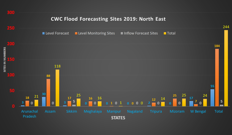
Summary The tables here shows that in 2018 CWC FF website had from NE India 148 sites in North East India comprising of 42 Level Forecasting, 100 Flood monitoring and 6 Inflow Forecast sites, out of these, 33 sites including 4 Level Forecast, 24 Level monitoring and 5 Inflow Forecast Sites were inactive.
This year, CWC has added 96 sites taking total tally to 244. Now there are 55 Level Forecasting, 184 Level Monitoring and 5 Inflow Forecasting sites in North East India.
About 50 percent (118) of the sites are in Assam state alone followed by Sikkim (25), Mizoram (25) West Bengal (Brahmaputra) (24), Arunachal Pradesh (21), Meghalaya (16) and Tripura (14). Like last year, there is still no site from Nagaland.
Summary Table of Level and Inflow Forecast, Monitoring Sites in North East India
| States | Level Forecast
Sites |
Level Monitoring Sites | Inflow Forecast
Sites |
Total | |||
| Active | Inactive | Active | Inactive | Active | Inactive | ||
| Arunachal Pradesh | 3 | 0 | 18 | 0 | 0 | 0 | 21 |
| Sikkim | 3 | 0 | 15 | 2 | 3 | 2 | 25 |
| Assam | 30 | 0 | 86 | 2 | 0 | 0 | 118 |
| Nagaland | 0 | 0 | 0 | 0 | 0 | 0 | 0 |
| Meghalaya | 0 | 0 | 14 | 2 | 0 | 0 | 16 |
| Manipur | 0 | 0 | 1 | 0 | 0 | 0 | 1 |
| Tripura | 2 | 0 | 12 | 0 | 0 | 0 | 14 |
| Mizoram | 0 | 0 | 20 | 5 | 0 | 0 | 25 |
| W Bengal | 17 | 0 | 7 | 0 | 0 | 0 | 24 |
| Total | 55 | 0 | 173 | 11 | 3 | 2 | 244 |
| NE India | 55 | 184 | 5 | 244 | |||
MAJOR GAPS Besides the large number of non functional sites and information gaps, there are other major gaps in CWC’s flood forecasting, some of them are listed below.
- North East being highly flood prone, CWC needs to do much more to ensure that its flood forecasts reach the people who are in flood prone areas.
- CWC has no flood forecasting sites in four full states: Manipur, Nagaland, Meghalaya and Mizoram. How can there be any justification for this?
- In whole of flood prone Manipur, CWC has just one monitoring site. No level or inflow forecasting sites. This is clearly hugely inadequate.
- Most of the Mizoram’s flood monitoring sites are not showing anything, this needs urgent attention. CWC also needs to add some key sites from Mizoram among its flood forecasting sites.
- CWC needs to add more sites in Tripura, considering the large number of rivers in this state.
- In Arunachal Pradesh, CWC has no sites in a number of important rivers, including Dibang, Ranganadi, among others. In the huge and important Siang basin, it certainly needs many more sites than the two that CWC has.
- For all the sites, the available information should be archived for at least five years and permanently for the HFL year.
In addition, there are many other issues with respect to the actual flood forecasting and monitoring by CWC, which are not dealt here.
A SANDRP analysis (ht.sandrp@gmail.com)
END NOTES:
- The sites shown with RED colour are inactive and shown with Sky Blue are newly added.
- Abbreviations List:
Warning Level – WL
Danger Level – DL
Full Reservoir Level – FRL
Maximum Water Level – MWL
High Flood Level – HFL
Meters – M
End Notes:
[I] http://india-water.gov.in/ffs/
[II] https://sandrp.in/2019/09/25/overview-of-cwc-flood-forecasting-sites-2019-north-india/
[III] The site does not have HFL level and time. Hydrograph for the site does not show WL, DL.
[IV] Earlier River name was given Lohit and DL, WL, HFL was given 140.6, 141.1, 144.46, year of HFL given as 1979.
[V] District is wrongly spelt as Subasiri in List Based Selection category.
[VI] HFL level and date for China Bridge site is still missing. River has been changed from Tawang to Manas.
[VII] Mathanguri was last year shown in Level Monitoring list with 102.28 as HFL attained on 30-10-1973. Now it has been included in Level Monitoring list and HFL level has been changed without giving any explanation.
[VIII] Previous HFL was 94.19 dated 25-06-1998, changed.
[IX] Previous HFL level was 79.87 date 4-09-1985.
[X] Site with same name repeated on Brahmaputra river.
[XI] Manas NH Crossing site is also shown in Bongaigaon district on Brahmaputra district with same WL, DL, HFL details.
[XII] HFL date for Dhubri is changed from 01-08-1989 to 28-08-1988 without giving any explanation.
[XIII] There is one more Level Monitoring site spelled as MATIJURI with same HFL Level and Date. Its Hydropraph is not updated.
[XIV] Annapurnaghat HFL date changed from 02-09-1989 to 01-08-1989 without giving any explanation.
[XV] Bokajan site is repeated twice. HFL details are given for one and missing for the other.
[XVI] Last year HFL level was given 76.18 on 12-09-1983 which changed to 75.73 on 25-09-2018 now. If 76.18 was correct, how can 75.73, lower level, become new HFL? No explanation given.
[XVII] PANBARI Level Monitoring site in Barpeta had earlier 55.73 HFL dated 28-08-1980. It has been changed now to 55.96 on 07-07-1991 without giving any explanation.
[XVIII] HFL details for KULSI Level Forecasting Site has been added now.
[XIX] HFL details have been added for SONAPUR Level Monitoring site now.
[XX] HFL Level, Date has been added now.
[XXI] HFL level is given for Bakshirhat Level Monitoring site but date is not mentioned. Hydrograph for the site is inactive.
[XXII] HFL Level, Date has been added now.
[XXIII] HFL Level changed from 36.3 date 31-07-1989 to 36.51 date 13-06-2018.
[XXIV] Dolasar river enters in Bangladesh from there.
[XXV] Dholai site is repeated with small/capital letter. One is shown Rukni river, second on Barak. Hydrograph for DHOLAI is not updated.
[XXVI] Borkhola site in same district Cachar and on same river Jatinga is mentioned twice. HFL detail is given for only one. Hydrograph for both are active.
[XXVII] Hydrograph of the site is not updated.
[XXVIII] HFL has been crossed at Kailashahar site in 2018. Previous HFL level was 25.79 dated 07-06-1993.
[XXIX] HFL level and date for Manughat site is changed from 46.6, 05-06-2001 to 46.97, 11-06-1993 without giving any explanation.
[XXX] Turial site is mentioned twice in small and capital letters. HFL level, date and hydrograph detail is not given for TURIAL.
[XXXI] HFL level, date for Sairang site unavailable last year has been included now.
[XXXII] Kolodyne river flows to Myanmar.
[XXXIII] Keitum site is now shown on Tuichang. Last year it was wrongly shown on Tlawng river.
[XXXV] Hydrograph is not updated timely. On 27 Sept it was updated upto 25 Sept. 2019.
[XXXVI] Hasimara site has been shifted to Level Forecasting from Level Monitoring.
[XXXVII] HFL level is changed to 82.33 and date 28-07-1972 from 81.33 date 28-08-1972 without giving any explanation.
