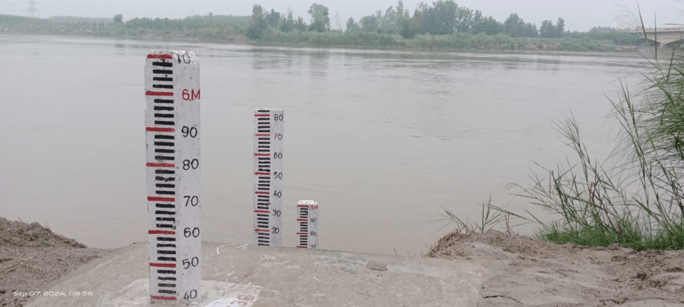
During southwest monsoon season 2024, SANDRP has tracked at least 64 flood forecast and flood monitoring sites where the respective rivers have crossed the highest flood levels (HFL). Here we present detailed analysis of these sites along with some key observations and other relevant information. SANDRP’s previous reports on the subject can be seen here: HFL breach incidents in 2018, 2019, 2020, May-Sept 2021, Oct.-Nov 2021, May-June 2022, July-October 2022, June-October 2023.
Continue reading “SW Monsoon 2024: Rivers Crossing Highest Flood Levels”Tag: Barak
2022: Overview of CWC’s Flood Monitoring Sites in North East India
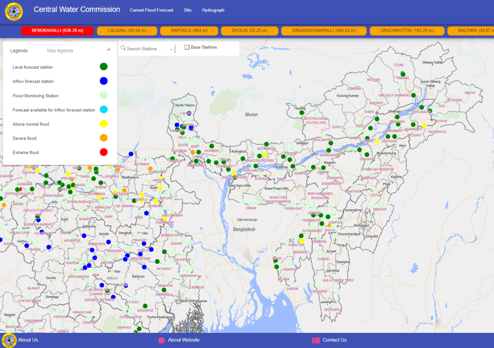
During monsoon CWC (Central Water Commission) monitors water level at several hundred sites in the county and publishes this information on its Flood Forecast website[I]. The website has three ways to get this information: Data Flow Map, List Based Exploration, and Hydrograph view. The Hydrograph view provides information for past 72 hours, supposed to be updated every hour. This is in addition to the list of current forecasts listed on the website.
Since 2018, SANDRP has been analyzing CWC’s flood forecast website in zone wise manner. After examining status of flood forecast and monitoring sites in North Indian[II] states, this overview is for North East India region covering Arunachal Pradesh, Assam, Meghalaya, Manipur, Nagaland, Tripura, Mizoram and Sikkim states. This also includes part of North West Bengal that is in Brahmaputra basin. Our 2018 and 2019 analysis on the North East region can be seen here[III] and here[IV]. .
Continue reading “2022: Overview of CWC’s Flood Monitoring Sites in North East India“
Rivers Breaching and flowing close to HFLs in May-June 2022
In pre-monsoon month of May 2022 and first month of south west monsoon season June 2022, there have been Highest Flood Level (HFL) breach incidents at 5 sites on rivers in North East and North India. The rivers have also touched or missed crossing the HFLs at 6 sites in the region in these two months. This include Kopili river at Kampur Level Forecast (LF) site in Nagaon district of Assam breaching HFL[i] in both May and June 2022 months and Barak river at Fulertal LF site in Cachar district, Assam narrowly missing HFL breach in May 2022 and breaching the extreme flood level in June 2022.
SANDRP has been tracking the HFL breach incidents during pre-monsoon and monsoon months for past four years. The analysis of such HFL breaches in 2018[ii], 2019[iii] and 2020[iv], May-Sept 2021[v], Oct.-Nov 2021[vi] can be seen on our website.
Continue reading “Rivers Breaching and flowing close to HFLs in May-June 2022”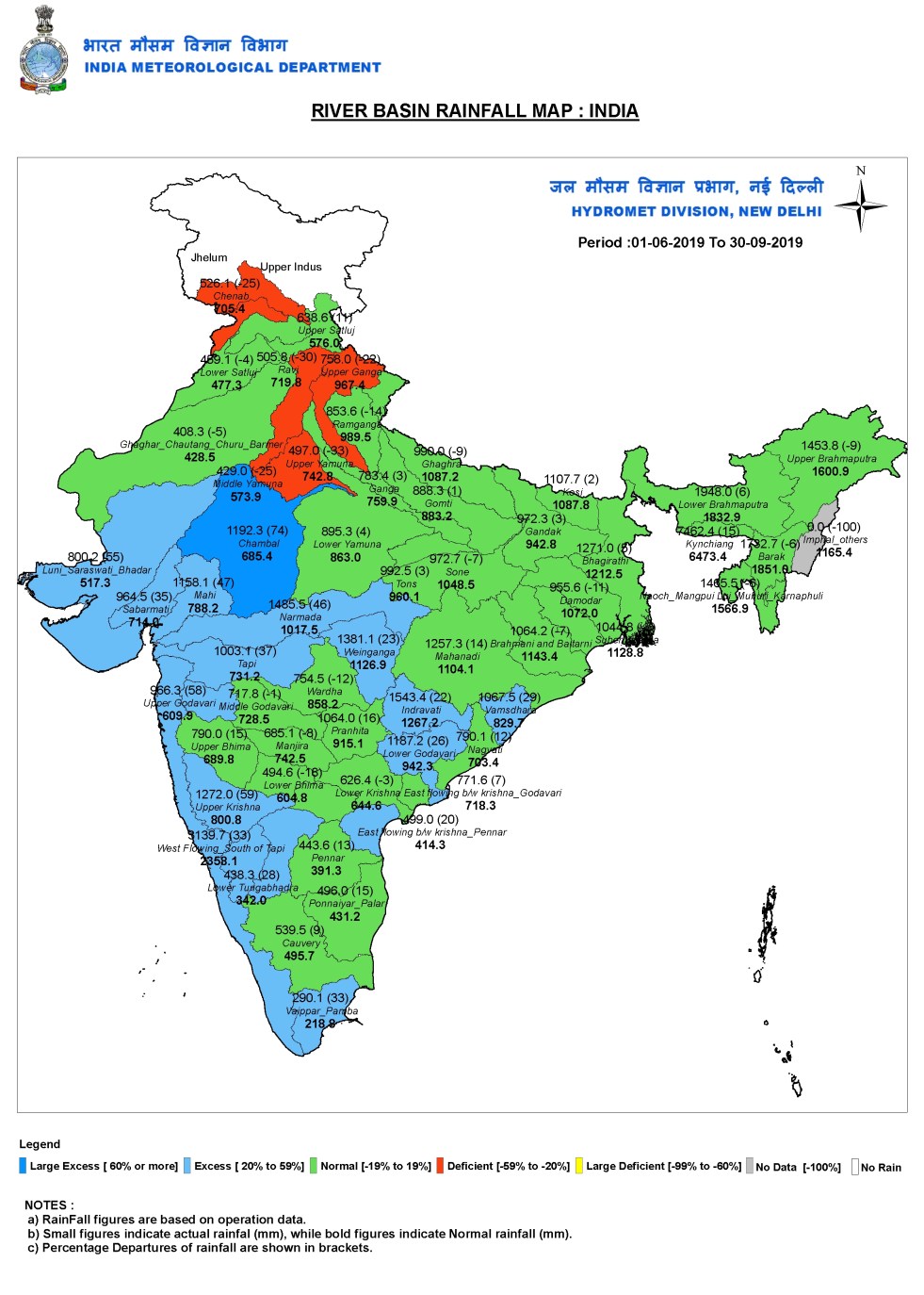
River Wise Rainfall in Monsoon 2019
Indian media never seems to report this, but IMD (India Meteorological Department) also provides river basin wise rainfall figures for South West Monsoon, also for other seasons. As in the previous years, here is an overview of the river basin wise rainfall during just concluded SW Monsoon 2019 (June-Sept 2019, though the monsoon started withdrawing only on Oct 9 and has not yet fully withdrawn from across India as I write this on Oct 15 2019), like the way we have been doing for the last three years[i]. Our earlier monsoon 2019 articles provided monsoon over view[ii], state wise rainfall figures[iii] and Marathwada specific situation[iv].
It’s not clear why Indian media does not report river basin wise rainfall figures, since that is arguably, the most appropriate way to look at the rainfall figures, since river basins are the hydrological units and the run off from the rainfall ends up in the rivers, and creates floods many times, as happened during 2019 monsoon. There could be issues of quality of the river basin wise rainfall figures, but that is true for all IMD’s rainfall figures at some level or other. Continue reading “River Wise Rainfall in Monsoon 2019”
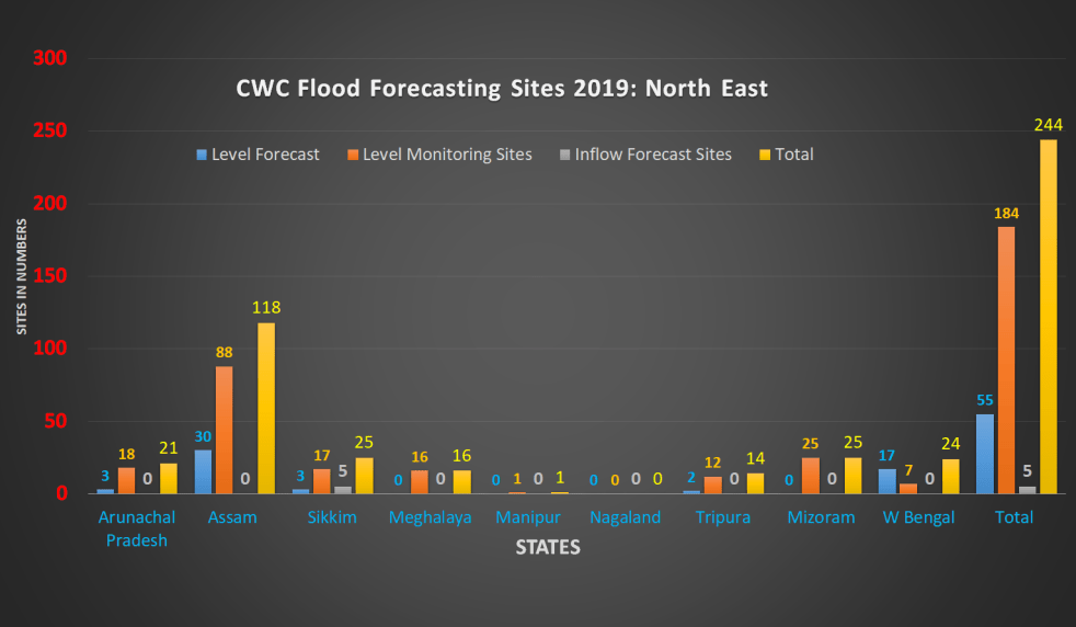
Overview of CWC’s Flood Forecasting Sites 2019: North East India
Central Water Commission (CWC) monitors water level at several hundred sites in the country during monsoon every year. It publishes this information on its Flood Forecast (FF) website[I]. The website has three ways to get this information: Data Flow Map, List Based Exploration, and Hydrograph view. The Hydrograph view provides information for past 72 hours, supposed to be updated every hour. This is in addition to the list of current forecasts.
The CWC’s FF website had in 2018 monsoon, information about 226 Flood Forecast Sites in the country comprising of 166 Level Forecast Sites and 60 Inflow Forecast Sites. It also monitors 700 Flood sites, information made available through List Based Exploration and Hydrograph View. As reported below, the number of sites have gone up during 2019 monsoon, which is welcome. However, most of the new sites, along with some old ones do not have key information.
Continue reading “Overview of CWC’s Flood Forecasting Sites 2019: North East India”
")
DRP: 22 May 2017 (SOLVE SILTATION OF GANGA OR REMOVE FARAKKA DAM TO REVIVE GANGA: BIHAR CM)
Bihar Chief Minister Nitish Kumar again has urged the central govt to remove the Farakka barrage in West Bengal and make a countrywide policy on silt management for letting river Ganga to flow freely.
“Siltation is destroying Ganga’s ecology and health. It’s due to heavy deposits of silt on the riverbed that stream of the river is being badly affected,” Kumar said at a two-day national seminar on ‘Obstacles in the Incessant Flow of the Ganga’.
Speaking on the occasion, Swami Avimukteshwara Anand criticised Union Water Resources Minister Uma Bharati for doing absolutely nothing for the cause of the river Ganga and said she seems more interested in her chair rather than the river. He also criticised Prime Minister Modi for claiming that he is son of Ganga, but doing nothing positive for the river. Swami ji said Nitin Gadkari seems bent on further destroying the river in the name of National Waterway.
Addressing the seminar Nitish Kukar said that Bihar’s demand for the framing of national policy on desiltation of the Ganga and clearance of silt in the state is not a political issue, as the matter is related to larger environmental and biodiversity issues facing the people.
He added, “Concrete steps have to be taken to ensure incessant flow of the Ganga. Otherwise, cleanliness of the river is not possible.” Referring to the need to protect biodiversity, he said conservation of the Ganga dolphins is dependent on the cleanliness of its water. He added the Farakka barrage constructed across the river in West Bengal has led to slow flow of water between Buxar to Bhagalpur, and consequent annual flood and waterlogging during the monsoon.
Nitish recalled the devastating flood that the state had witnessed in the Ganga basin last year and said Bihar had spent Rs 1,058 crore over the last five years to prevent soil erosion. He appealed to the Centre to frame a sound policy on silt management, stressing that it should be prepared by making on the spot survey and assessment of the prevailing situation. Nitish said even the report of the committee headed by Madhav Chitale had accepted the problem of siltation facing the Ganga.
Continue reading “DRP: 22 May 2017 (SOLVE SILTATION OF GANGA OR REMOVE FARAKKA DAM TO REVIVE GANGA: BIHAR CM)”
North-East India (Excluding-Brahmputra) Rivers Profile
The River system in North East, other than the Brahmaputra, can be classified as the Barak River system and minor Rivers flowing to Bangladesh and Burma. The Barak River, Gumti River, Myntdu River etc are some of the major Rivers flowing to Bangladesh, while the Kaladan River, the Manipur River, Tizu River etc flowing in the States of Mizoram, Manipur and Nagaland are main Rivers flowing to Burma.
The Barak River basin covers parts of India, Bangladesh and Myanmar. In India it spreads over states of Meghalaya, Manipur, Mizoram, Assam, Tripura and Nagaland having an area of 41,723 Sq.km.
The Barak River originates from the Manipur hills, from Liyai Village in Senapati district in Manipur at an elevation of 2,331 m and flows through Assam and further down to Bangladesh, where it is known by the name of the Surma and the Kushiyara and later called the Meghna before receiving the combined flow of the Ganga and the Brahmaputra. The principal tributaries of Barak joining from north bank are the Jiri, the Chiri, the Modhura, the Jatinga, the Harang, the Kalain and the Gumra whereas the Dhaleswari, the Singla, the Longai, the Sonai and the Katakhal joins from south bank. The Barak sub-basin lies in the States of Meghalaya, Manipur, Mizoram, Assam, Tripura and Nagaland.
Continue reading “North-East India (Excluding-Brahmputra) Rivers Profile”
