In the monsoon season of 2019 Indian rivers have crossed Highest Flood Level (HFL) at around 37 Level Forecasting and Level Monitoring sites across the country. This account attempts basin wise details and description of HFL breached by the rivers.
Brahmaputra Basin (Assam)
In Brahmaputra basin 2 sites, 1 Aie NH Xing Level Monitoring site on River Aie in Barpeta district of Assam and Dhubri (Level Forecast) site on River Brahmaputra in Dhubri district of Assam narrowly crossed the HFL in July 2019.
Also River Barak at ANIPUR site in Karimganj district on May 24 and River Brahmaputra at Goalpara site in Goalpara district rose close to the HFL level on July 17, 2019. As per CWC (Central Water Commission) FF Website, Goalpara site has not crossed HFL since 1954.
| SN | Site | River | District | Old HFL, M | Date | New HFL, M | Date |
| 1 | AIE NH XING | Aie | Barpeta | 53.26 | 21-08-2015 | 53.27 | 11-07-2019 |
| 2 | Dhubri | Brahmaputra | Dhubri | 30.36 | 28-08-1988 | 30.38 | 18-07-2019 |
Hydrographs show Aie, Brahmaputra rivers narrowly crossing HFL at Aie NH Xing and Dhubri sites.
Hydrographs of rivers in Brahmaputra basin which flew close to HFL.
Mahanadi Basin, Odisha
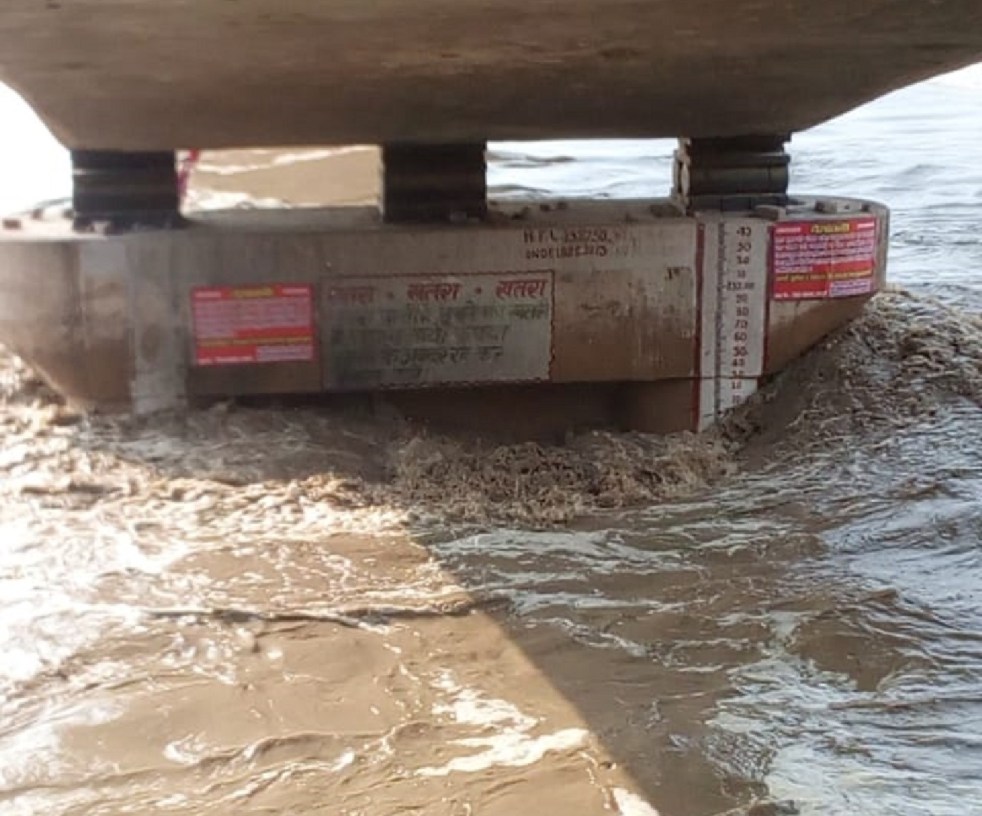
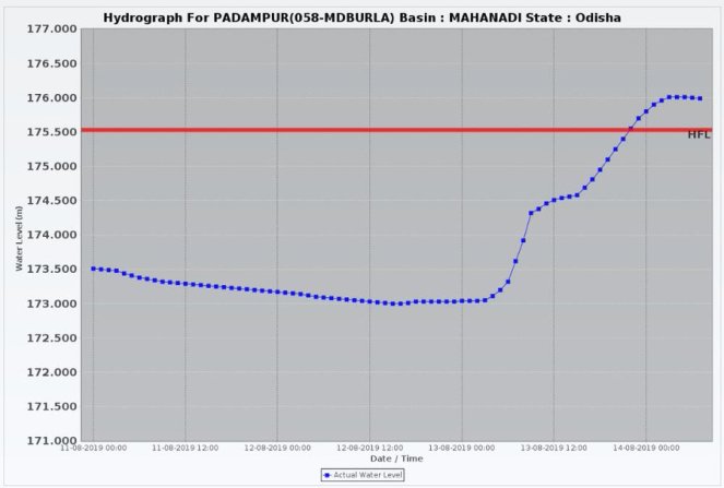
The Ong river in Baragarh district crossed the HFL at Padampur Level Monitoring site on August 14, 2019. The river crossed HFL just before 10 pm on Aug 13, 2019 and rose steeply to new HFL, about half a meter above the previous HFL reached only last year. The river water level fell below the earlier HFL by around 1500 hours on Aug 14, 2019.
| SN | Site | River | District | Old HFL, M | Date | New HFL, M | Date |
| 1 | Padampur | Ong | Baragarh | 175.53 | 16-08-2018 | 176.0 | 14-08-2019 |
Ganga Basin (Bihar, Himachal Pradesh, Rajasthan, Uttar Pradesh)
In Bihar the Jhanjharpur Level Forecast site on Kamalabalan river in Madhubani district crossed the HFL with narrow margin whereas the Adhwara river at Sonbarsa Level Forecast site in Sitamarhi district almost touched the HFL on July 13, 2019.
Hydrographas of rivers touching/ crossing HFL in Bihar state.
Similarly the Bagmati river at Dheng Bridge Level Forecast site in Sitamarhi was forecasted to cross the HFL 73.0 attained on 13 August 2019 but it just touched the HFL and started receding.
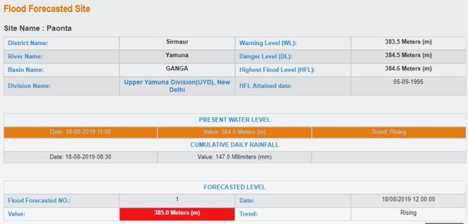
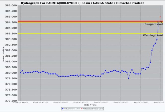
In Himachal Pradesh, the Yamuna river was forecasted to cross the previous HFL 384.6m attained on September 5, 1995 at Paonta Level Forecast site on August 18, 2019 but it could not go beyond 384.1m and started falling.
In Rajasthan the Kalisind river breached the HFL at Salavad Level Monitoring site twice, first on Aug 15-16 and then on September 14-15, 2019. River Chambal at Mandawara Level Monitoring site crossed the HFL (217.685 m) during Sept 13-18, 2019 and the new HFL was reached around 8 am on Sept 16, 2019 almost by 8 meters above previous HFL. The water level remained above HFL at least till Sept 18, 2019.
In Uttar Pradesh Chambal River crossed the HFL of UDI Level Monitoring site on Sep 18, 2019.
Chambal, Kalisind rivers crossing HFL following water releases from Gandhi Sagar dam.
The HFL breach incidents in Chambal river were result of sudden water release from Gandhi Sagar dam on September 15, 2019. For details, kindly see Man made National Crisis at Gandhi Sagar Dam in Sept 2019.
| SN | Site | River | District | Old HFL, M | Date | New HFL, M | Date |
| Bihar | |||||||
| 1 | Sonbarsa | Adhwara | Sitamarhi | 83.0 | NA | 83.0 | 13-07-2019 |
| 2 | Dheng Bridge | Baghmati | Sitamarhi | 73.0 | 13-08-2017 | 73.0 | 14-07-2019 |
| 3 | Jhanjharpur | Kamalabalan | Madhubani | 53.01 | 10-07-2004 | 53.03 | 14-07-2019 |
| Rajasthan | |||||||
| 4 | Salavad | Kalisind | Jhalawar | 320.72 | 21-08-1996 | 321.20 | 15 (1800)-16 (0500) Aug |
| 321.700 | 14 (1000)-15 (0900) Sep | ||||||
| 5 | Mandawara | Chambal | Kota | 217.685 | 02-09-2006 | 225.600 | 13 (1200)-18 (0800) Sep |
| Uttar Pradesh | |||||||
| 6 | Udi | Chambal | Etawah | 128.4 | 24-08-1996 | 128.6 | 18-09-2019 |
Godavari Basin (Maharashtra, Madhya Pradesh)
River Godavari at Nasik Level Forecast site breached the HFL on August 4, 2019 and it was expected to rise further. The new HFL is almost 0.5 m above the previous HFL, reached in 2016.
Wainganga, a tributary of Godavari in Balaghat district Madhya Pradesh crossed the HFL at Kumhari Level Monitoring site on September 9, 2019, breaching the 25 year old HFL. The new HFL here is about 1.2 m above the previous HFL.
| SN | Site | River | District | Old HFL, M | Date | New HFL, M | Date |
| Maharashtra | |||||||
| 1 | Nasik | Godavari | Nasik | 563.01 | 02-08-2016 | 563.500 | 04-08-2019 |
| Madhya Pradesh | |||||||
| 2 | Kumhari | Wainganga | Balaghat | 305.5 | 21-07-1994 | 306.700 | 09-09-2019 |
Krishna Basin (Maharashtra, Karnataka)
Several Rivers in Krishna basin including Panchganga, Warna in Maharashtra and Tunga, Ghatprabha, Malprabha, Dudhganga, Varadha in Karnataka breached the previous HFL during south west monsoon 2019.
Out of 11 HFL crossing events, 10 took place between 7 and 11 August 2019. Out of these 11 sites 2 (Terwad on Panchganga and Huvinhedigi on Krishna) are Level Monitoring sites and the rest are Level Forecast sites.
Hydrographs of CWC sites in Krishna basin in Maharashtra crossing HFL.
River Krishna flowed close to the HFL level at Navalgund site but did not cross it. HFL details for Navalgund and Mudhol sites unavailable earlier on the CWC FF website has been added now.
The flood in Krishna basin was hugely aggravated by massive and sudden water releases from the dams resulting in breach of HFLs in sequence. For more information, kindly see Aug 2019 Krishna Basin Floods in Maharashtra – Karnataka: How dams harming rather than helping and Aug 2019 Krishna Basin floods in Karnataka & the Role of Dams.
| SN | Site | River | District | Old HFL, M | Date | New HFL, M | Date |
| Maharashtra | |||||||
| 1 | Ajunwad | Krishna | Sangli | 543.69 | 05-08-2005 | 544.3 | 09 (0800) -10 (1600) Aug |
| 2 | Terwad | Panchganga | Kolhapur | 540.39 | 05-08-2005 | 542.14 | 07 (1600) – 14 (2000) Aug |
| 3 | KURUNDWAD | Krishna | Kolhapur | 539.76 | 05-08-2005 | 541.2 | 07 (2200) -13 (1700 Aug |
| 4 | Samdoli | Warna | Sangli | 546.324 | 05-08-2005 | 546.954 | 08 (0000) – 10 (2300) Aug |
| Karnataka | |||||||
| Navalgund | Krishna | Dharwad | 568.57 | 16-10-2017 | 568.40 | 21-10-2019 | |
| 5 | Huvinhedigi | Krishna | Raichur | 358.22 | 02-10-2009 | 358.30 | 11 (0700-2000) & 13 (2300) -14 (1300) Aug |
| 6 | Shimoga | Tunga | Shimoga | 568.28 | 15-07-1994 | 570.20 | 07 (0700) – 11 (2300) Aug |
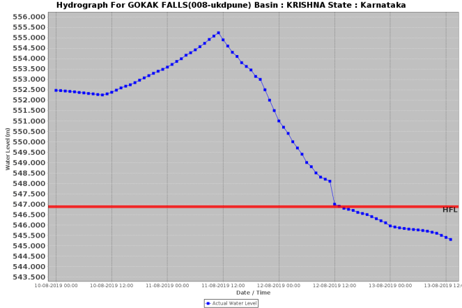
| 7 | Gokak Falls | Ghatprabha | Belgaum | 546.88 | 23-08-2005 | 555.3 | 06 (0600) – 12 (1300) Aug |
| 8 | Mudhol | Ghatprabha | Bagalkot | 538.25 | NA | 544.7 | 06 (1300) – 14 Aug |
| 539.70 | 21 (1000) -25 (1000) Sep | ||||||
| 9 | Sadalga | Dudhganga | Belgaum | 538.9 | 06-08-2005 | 540.58 | 07 (0600) – 14 (1200) Aug |
| 10 | Cholachguda | Malaprabha | Bagalkot | 536.84 | 02-10-2009 | 537.1 | 10 Aug |
| 11 | Marol | Varadha | Dharwad | 517.601 | 18-11-1992 | 518.18 | 09 (2200) – 12 (1400) Augx |
Hydrographs CWC sites in Krishna basin, Karnataka crossing HFL.


Hydrographs of Navalgund site showing Krishna river flowing close to HFL.
Cauvery Basin (Karnataka, Kerala, Tamil Nadu)
In Cauvery basin, previous HFLs are breached or touched at 11 locations across Karnataka, Kerala and Tamil Nadu. Out the total 11 locations, 9 are Level Monitoring (shown with italic fonts) and 2 are Level Forecasting sites. Previous HFL breach date is not available for 6 sites.
The most interesting case has been of Thoreshettahalli Level Monitoring site, where River Shimsha has crossed the HFL 4 times in the monsoon season. The previous HFL was set only in November 2018.
| SN | Site | River | District | Old HFL, M | Date | New HFL, M | Date |
| Karnataka | |||||||
| 1 | KOLLEGAL | Cauvery | Chamaraja nagara | 630.25 | NA | 630.25 | 13-08-2019 |
| 2 | THIMMANAHALLI | Yagachi | Hassan | 909.665 | 16-07-2009 | 912.700 | 09 (1000) – 10 (2100) Aug |
| 3 | SAKLESHPUR | Hemavathi | Hassan | 893.4 | 17-07-2000 | 894.18 | 08 (0100) – 11 (1800) Aug |
| 4 | AKKIHEBBAL | Hemavathi | Mandya | 752.56 | NA | 754.8 | 10 (0600) – 12 (0400) Aug |
| 5 | T. NARASIPUR | Kabini | Mysore | 642.4 | NA | 642.8 | 11 (2100) – 12 (1500) Aug |
| 6 | T.K.HALLI | Shimsha | Mandya | 585.95 | NA | 585.90 | 24-09-2019 |
| 7 | THORESHETTAHALLI | Shimsha | Mandya | 622.86 | 25-11-2018 | 623.42
623.59 623.90 623.04 |
23 (0800) – 24 (1200) Sep
03 (0700) – 05 (0700) Oct 06 (0700) – 09 (1000) Oct 22 (0300) – 24 (0400) Oct |
| 8 | T. BEKKUPE | Arkavathi | Bangalore Rural | 606.95 | NA | 606.95 | 03-10-2019 |
| Kerala | |||||||
| 9 | MUTHANKERA | Kabini | Wyand | 713.26 | 17-08-2018 | 713.90 | 09 (0000) – 10 (2000) Aug |
| Tamil Nadu | |||||||
| 10 | NELLITHURAI | Bhavani | Coimbatore | 309.45 | 15-11-1992 | 309.45 | 9(00-0500) Aug; 10 (02-0300) Aug |
| 11 | BILIGUNDULU | Cauvery | Dharmapuri | 265.84 | NA | 266.25 | 12 (1100) – 13 (0600) Aug |
Hydrographs of CWC sites in Cauvery Basin, Kerala & Tamil Nadu crossing HFL.
West Flowing Rivers (WFR), Kerala
| SN | Site | River | District | Old HFL, M | Date | New HFL, M | Date |
| 1 | PERUMANNU | Valapatnam | Kannur | 15.55 | 08-08-2018 | 18.200 | 08-08-2019 |
| 2 | KUTTYADI | Kuttyadi | Kozhikode | 8.36 | 16-08-2018 | 8.70 | 8 (1800) – 9 (0300) Aug |
| 3 | KUNIYIL | Chaliyar | Mallapuram | 10.63 | 14-07-1994 | 12.10 | 09 (0200) -10 (1600 ) Aug |
| 4 | PULAMANTHOLE | Pulanthodu | Palakkad | 19.94 | 16-08-2018 | 20.20 | 9 (1000) – 10 (0000) Aug |
Summary The new HFL record mentioned in this report is based on the available hydrographs and CWC reports of that day. The exact level may be more and could only be known once the CWC updates the HFL information which its not doing promptly or in time bound manner. Secondly this report tried to list all the HFL breaching events, however there could be more rivers whose information could be unavailable online or which could have escaped monitoring by CWC.
Summary of HFL crossing sites during Monsoon 2019
| River Basin | State wise number of sites | Total no of sites |
| Brahmaputra | Assam | 2 |
| Mahanadi | Odisha | 1 |
| Ganga | Bihar-3; Rajasthan-2; UP-1 | 6 |
| Godavari | Mah-1; MP-1 | 2 |
| Krishna | Karnataka-7; Mah-4 | 11 |
| Cauvery | Karnataka-8; Kerala-1; TN-2 | 11 |
| WRF of Kerala | Kerala-4 | 4 |
| TOTAL | Assam-2; Odisha-1; Bihar-3; Rajasthan-2; UP-1; Mah-5; MP-1; Karnataka-15; TN-2; Kerala-5 | 37 |
So Karnataka, a non traditional flood affected state has the highest number of HFL crossing events, where as traditional flood affected states like Bihar, UP and Assam has very few such sites during Monsoon 2019. Krishna and Cauvery, which are known more for droughts than floods have the highest number of HFL crossing events, whereas Ganga and Brahmaputra have much fewer such events. South India (Karnataka, Kerala, TN) has 22 of the 37 HFL crossing sites, whereas North and North East India has much fewer. The climate change impact is clearly visible in the monsoon 2019.
In terms of the difference between old HFL and new HFL, three sites stand out: Mandwara (Chambal river, Rajasthan downstream of Gandhi Sagar Dam): 7.915 m; Mudhol (Ghataprabha river in Karanataka) 6.45 m, but the highest increase is at Gokak Falls (Ghataprabha river, Karnataka downstream of Hidkal Dam) at 8.42 m. Its striking that each of these three highest HFL increase events are associated with upstream dams. In terms of duration for which water level remained above old HFL, Mudhol had the highest duration, over over eight days.


CWC’s different flood monitoring sites in Kerala and Karnataka states battling flood waters.
About Flood Monitoring and Forecasting by CWC During monsoon season, Central Water Commission (CWC) measures and forecasts flood level in some of the river basins in India. CWC has 325 Flood Forecasting Station consisting of 197 Level Forecasting Stations and 128 Inflow Forecasting Stations for Dams/Reservoirs in addition around 1500 flood monitoring sites. However, not all of these are functional with equal rigour and efficiency.
Apart from monitoring work, CWC publishes Daily Flood Bulletin and Daily Flood Situation Report cum Advisories, in addition to Special Advisories for states facing severe flood threats.
The Daily Flood Bulletin shares information about flood situation at Level Forecast sites across the country as per situation at the end of the working hours on that day. Under first part of the report, the Level Forecast sites are divided into 3 categories A, B and C with Red, Orange and Yellow colour codes. Level Forecast sites in A category with Red colour shows Extreme Flood Situation where the previous HFL is exceeded or equalled.
B category with orange colour lists the Level Forecast sites with Severe Flood Situation where water level is touching or exceeding the Danger Level but remains below HFL. Under C category shown with Yellow colour, Level Forecast sites listed are those with Above Normal Flood Situation where water level is either touching or exceeding the Warning Level but flows below Danger Level.
Similarly under second part, information is given for Inflow Forecast sites where Inflows are equal or exceed the specified Threshold Limit for a particular reservoir / barrage.
The Daily Flood Situation Report cum Advisories present overview on the current flood situation in the country including IMD rainfall forecast for next five days, description and hydrographs of key flood locations and issues advisories to states likely to face extreme or severe flood situations. It provides useful overview of the current flood scenario on a given date.
In Conclusion Floods are part of natural cycles, but not all floods are due to natural causes. India’s monsoon have been witnessing more extreme weather events marred with sudden heavy rainfalls and prolonged dry periods. At the same time floods are bringing more damages also due to wrong operation of dams. The faulty operations of dams during monsoon season is also proving to be determining factor in HFL crossing events against the natural flood cycles as seen in Chambal and Krishna rivers basin this year.
On the basis of CWC reports, it seems that during south west monsoon season this year, rivers have breached or touched the previous HFL at least at 37 locations (THORESHETTAHALLI site on Shimsha river in Mandya district where HFL is breached 4 times in this monsoon season alone, but have been counted once each). Of which 16 are Level Forecast sites and 21 are Level Monitoring sites. However CWC’s daily reports contain information only about Level Forecast sites and excludes details of Level Monitoring sites.
Two different screenshots of CWC’s twitter account showing Daily Flood Bulletin (above) and Hydrographs level monitoring sites crossing HFL. However, these find no mention in Daily Flood Bulletin.
Moreover the Daily Flood Bulletin and Daily Flood Situation cum Advisories reports are not uploaded regularly. During floods in Krishna basin in second week of August 2019, the Daily Flood Bulletin lacked information on forecasted level for all the four sites in extreme flood situation as shown in screenshots of the report below.
Flood Bulletin lacked information on forecasted level for all the four sites in extreme flood situation. Furthermore, the Gokak Falls Level Forecast site remained in extreme flood situation flowing above HFL for four days during August 7-11, 2019 but CWC reports carried no flood details or hydrograph about the situation except one or two lines describing the event.
Similarly CWC on September 18 tweeted that in the month of August 2019, HFL was breached at 25 locations mostly in south India. But CWC did not provide the full list and details of it. CWC reports of the day carried no information of the same.
Apart from this, CWC seems to have no archive containing details of HFL crossing events and relevant hydrographs available in public domain. In fact all flood forecasting work of CWC must be archived and publicly available for following years.
There are many floods that CWC fails to forecast or monitor. For example, the unprecedented floods in west flowing Kali river basin in Uttara Kannada district of Karnataka did not figure in CWC’s flood forecasting work at all.
Composed by Bhim Singh Rawat (bhim.sandrp@gmail.com)
