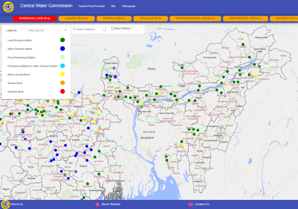
During monsoon CWC (Central Water Commission) monitors water level at several hundred sites in the county and publishes this information on its Flood Forecast website[I]. The website has three ways to get this information: Data Flow Map, List Based Exploration, and Hydrograph view. The Hydrograph view provides information for past 72 hours, supposed to be updated every hour. This is in addition to the list of current forecasts listed on the website.
Since 2018, SANDRP has been analyzing CWC’s flood forecast website in zone wise manner. After examining status of flood forecast and monitoring sites in North Indian[II] states, this overview is for North East India region covering Arunachal Pradesh, Assam, Meghalaya, Manipur, Nagaland, Tripura, Mizoram and Sikkim states. This also includes part of North West Bengal that is in Brahmaputra basin. Our 2018 and 2019 analysis on the North East region can be seen here[III] and here[IV]. .
Abbreviations List
| Level Forecast | LF |
| Level Monitoring | LM |
| Inflow Forecast | IF |
| Meters | M |
| Warning Level | WL |
| Danger Level | DL |
| Highest Flood Level | HFL |
| Hydrograph Active | HA |
| Full Reservoir Level | FRL |
| Maximum Water Level | MWL |
| Not Available | NA |
ARUNACHAL PRADESH
Arunachal Pradesh had 11 flood monitoring sites comprised of 2 Level Forecast (LF) and 9 Level Monitoring (LM) sites which were increased to 21 by adding 1 LF and 9 LM sites. As of July 2022, the CWC has added 9 more LM sites in the state taking the final tally to 30 sites including 3 LF and 27 LM sites.
CWC has corrected several inaccuracies which were earlier highlighted by SANDRP. However, there are still some issues as mentioned below which require CWC’s attention.
The state has no Inflow Forecast (IF) site. Highest Flood Level (HFL), date for Yinkiang LF site is still missing. The river name, WL, DL, HFL and date has been changed for Namsai LF site without any clarification. River name for Bolent and Jotte LM sites has been changed from Siyum to Siang and from Dikrong to Sinki respectively. Name of Muruga bridge LM site has been changed to Murga bridge.
Out of 27 LM sites HFL, date is not mentioned for 9 sites while hydrographs for 5 LM sites is inactive which means only 22 LM sites are currently working. Additionally, hydrographs for most of the sites are running late by 6 to 3 hours.
Arunachal Pradesh List Level Forecast Sites in 2022
| SN | Site | River/ Basin | District | WL | DL | HFL, M | HFL Date | HA? |
| 1 | Yinkiang | Siang / Brahmaputra | Upper Siang | 303 | 304 | NA | NA | Yes |
| 2 | Passighat | Siang / Brahmaputra | East Siang | 152.96 | 153.96 | 157.54 | 11.06.2000 | Yes |
| 3 | Namsai | Nao Dehing/ Brahmaputra | Lohit | 144.8 | 145.8 | 146.6 | 31.08.1974 | Yes |
| Lohit/ Brahmaputra | 140.6 | 141.1 | 144.46 | 07.10.1979 |
Arunachal Pradesh List of Level Monitoring Sites in 2022
| SN | Site | River/Basin | District/Town | HFL, M | HFL Date | HA? |
| 1 | Hayuliang | Lohit/ Brahmaputra | Anjaw | 4595.47 | 04.09.2008 | Yes |
| 2 | Kibithu | Lohit/ Brahmaputra | Anjaw | 1230.26 | 11.08.2017 | Yes |
| 1229.8 | 25.07.2016 | |||||
| 3 | Tezu | Lohit/ Brahmaputra | Lohit | 192.14 | 16.07.1996 | Yes |
| 4 | Pagoda | Lohit/ Brahmaputra | Namsai | NA | NA | Yes |
| 5 | Lemeking | Subansiri/ Brahmaputra | Upper Subansiri | 1107.16 | 27.07.2016 | Yes |
| 6 | Daporizo | Subansiri / Brahmaputra | Upper Subansiri | 213.9 | 15.10.1987 | Yes |
| 7 | Subansiri Lower Dam | Subansiri/ Brahmaputra | Lower Subansiri | NA | NA | No |
| 8 | Tamen | Subansiri/ Brahmaputra | Lower Subansiri | NA | NA | Yes |
| 9 | Yazali | Ranganadi/ Brahmaputra | Lower Subansiri | 623.1 | 14.06.2008 | No |
| 10 | Tuting | Siang / Brahmaputra | Upper Siang | 435.93 | 06.09.2010 | Yes |
| 420.43 | ||||||
| 11 | Yingkiong | Siang/ Brahmaputra | Upper Siang | NA | NA | Yes |
| 12 | Pangin | Siang/ Brahmaputra | East Siang | NA | NA | Yes |
| 13 | Boleng | Siang/ Brahmaputra | West Siang | NA | NA | Yes |
| 14 | Seppa | Kamang/ Brahmaputra | East Kameng | 342.6 | 26.06.1998 | Yes |
| 15 | Bhalukpong | Kameng/ Brahmaputra | West Kameng | 141.79 | 16.06.1989 | Yes |
| 16 | Bana | Kamang / Brahmaputra | West Kameng | NA | NA | No |
| 17 | Kabu basti | Siyum/ Brahmaputra | West Siang | 256.78 | 24.081999 | Yes |
| 18 | Mechuka | Siyum/ Brahmaputra | West Siang | NA | NA | No |
| 19 | Miao | Nao Dehing / Brahmaputra | Changlang | 241.57 | 09.07.2004 | Yes |
| 20 | Motipur | Nao Dehing / Brahmaputra | Changlang | 218.16 | 26.06.2012 | Yes |
| 21 | Doimukh | Dikrong/ Brahmaputra | Papum Pare | 121.08 | 17.06.2022 | Yes |
| 22 | Jollang | Sinki/ Brahmaputra | Papum Pare | NA | NA | Yes |
| 23 | Jotte | Sinki/ Brahmaputra | Papum Pare | NA | NA | Yes |
| 24 | Chimpu | Sinki/ Brahmaputra | Papum Pare | NA | NA | Yes |
| 25 | China Bridge | Manas / Brahmaputra | Tawang | NA | NA | Yes |
| 26 | Murga Bridge | Tawang Chu/ Brahmaputra | Tawang | NA | NA | Yes |
| 27 | MS Jang | Mago Chu/ Brahmaputra | Tawang | NA | NA | No |
Arunachal Pradesh List of New Level Monitoring Sites ADDED in 2022
| SN | Site | River | District | HFL, M | HFL Date | HA? |
| 1 | Hayuliang | Lohit/ Brahmaputra | Anjaw | 4595.47 | 04.09.2008 | Yes |
| 2 | Subansiri L Dam | Subansiri/ Brahmaputra | Lower Subansiri | NA | NA | No |
| 3 | Tamen | Subansiri/ Brahmaputra | Lower Subansiri | NA | NA | Yes |
| 4 | Bana | Kamang / Brahmaputra | West Kameng | NA | NA | No |
| 5 | Mechuka | Siyum/ Brahmaputra | West Siang | NA | NA | No |
| 6 | Motipur | Nao Dehing / Brahmaputra | Changlang | 218.16 | 26.06.2012 | Yes |
| 7 | Doimukh | Dikrong/ Brahmaputra | Papum Pare | 121.08 | 17.06.2022 | Yes |
| 8 | Chimpu | Sinki/ Brahmaputra | Papum Pare | NA | NA | Yes |
| 9 | MS Jang | Mago Chu/ Brahmaputra | Tawang | NA | NA | No |
ASSAM
As of July 2022, there are 83 sites listed in the state. In last 2 years, CWC has upgraded 6 LM sites into LF sites, added 3 new LM sites and has removed 39 LM sites; list of all these sites are given in separate tables below.
Moreover, CWC has repeated 2 LF and 2 LM sites while 2 LM sites are inactive. These 6 sites are mentioned but not calculated in this analysis. Therefore, currently there are 77 flood monitoring sites active in Assam including 36 LF and 41 LM sites. The state has no IF site. The other problems in LF and LM sites in state are mentioned below separately.
Assam: Issues in LF sites 1 Mathanguri was earlier LM site in Barpeta district with 102.28 m as HFL dated 30.10.1973. It has been upgraded into LF site in Chirang district and HFL has been changed to 100.28 m without the date. New HFL is lower than old one.
2. Bokajan LM site has been upgraded into LF site. Its WL is missing.
3. CWC has increased WL and DL for Numaligarh, Neamatighat and Puthimari NH Rd Xing LF sites without any explanation.
4. The date for previous HFL for Dhubri LF site was changed to 28.081988 from 01.08.1989.
5. The Mathanguri LF site is now listed in Chirang district. Its HFL is changed to 100.28 m without mentioning the date. Earlier it was put in Barpeta district with 102.28 m as HFL dated. 30.10.1973. The old HFL is higher than the new one.
6. CWC has 2 sites named Dholai. Previously both were LM sites with same HFL, date. But now one has been upgraded into LF site for which WL is not given.
7. CWC has upgraded Fulertal LM site into LF site but has not given the WL which was shown in hydrograph on 21.06.2022 when old HFL was breached at this site.
8. CWC has repeated Matijuri site (previously spelt Matizuri). One is LF site and second one is LM site with same HFL, date.
9. HFL date for Annapurnaghat has been changed from 02.09.1989 to 01.08.1989.
Assam: Issues in LM sites 1. CWC has changed districts for Matunga, DRF, Harangajao, Suklai, Panbari, Bahalpur, Lakhipur, Borkhola, Fakirabazar and Badarpur Ghat LM sites. Similarly, river names have been changed for Badarpur Ghat, Dihingmukh and Fakirabazar LM sites. The old districts are given separately in rows below the particular sites.
2. CWC has also changed the name of AP Ghat and BP Ghat to Annapurana Ghat and Badarpur Ghat. Interestingly, there are 2 LF sites with same name.
3. The hydrograph for DRF LM site suggests technical error in data entry on 19.06.2022 when the site is mentioned as crossing old HFL.
4. The previous HFL 101.05 m dated 18.061995 for Gelabil LM site is higher than 99.34 m dated 29.08.1999.
5. The old HFL for Suklai LM site 76.18 m dated 12.09.1983 is higher than 75.73 m dated 25.09.2018 and 75.85 m dated 25.06.2020 which is its current HFL. It is worth to mention that the river has touched the 75.85 m HFL on 16.06.2022 this year.
6. The Dudhnai and Dudhnoi LM sites are same but listed twice by CWC.
7. CWC has added Bazar in Gumra LM site but has not named the river which is given by us on the basis of previous record.
8. HFL dates for about 11 LM site is missing. Hydrographs for several LM sites is running late by 02 to 05 hours.
Assam List of Level Forecast Sites in 2022
| SN | Site | River/ Basin | District/ Town | WL, M | DL, M | HFL, M | HFL Date | HA? |
| 1 | Margherita | Buridehing/ Brahmaputra | Tinsukia | 133.42 | 134.42 | 137.51 | 26.08.1988 | Yes |
| 2 | Naharkatia | Buridehing/ Brahmaputra | Dibrugarh | 119.4 | 120.4 | 122.69 | 17.06.1973 | Yes |
| 3 | Chenimari (Khowang) | Buridehing/ Brahmaputra | Dibrugarh | 101.11 | 102.11 | 104.16 | 02.09.2015 | Yes |
| 4 | Bokajan | Dhansiri (S)/ Brahmaputra | Karbi Anglong | NA | 133.3 | 135.13 | 09.10.1986 | Yes |
| 5 | Golaghat | Dhansiri (S)/ Brahmaputra | Golaghat | 88.5 | 89.5 | 92.45 | 11.10.1986 | Yes |
| 6 | Numaligarh | Dhansiri (S)/ Brahmaputra | Golaghat | 77.42 | 78.42 | 80.16 | 02.08.2018 | Yes |
| 76.42 | 77.42 | 80.16 | 03.08.2018 | |||||
| 79.87 | 04.09.1985 | |||||||
| 7 | Dholabazar | Lohit/ Brahmaputra | Tinsukia | 127.27 | 128.27 | 130.07 | 22.09.2012 | Yes |
| 8 | Dillighat | Desang/ Brahmaputra | Dibrugarh | 128 | 129 | 129.65 | 28.08.1977 | Yes |
| 9 | Nanglamoraghat | Desang/ Brahmaputra | Sibsagar | 93.46 | 94.46 | 96.49 | 06.09.1998 | Yes |
| 10 | Dibrugarh | Brahmaputra/ Brahmaputra | Dibrugarh | 104.7 | 105.7 | 106.48 | 03.09.1998 | Yes |
| 11 | Neamatighat | Brahmaputra/ Brahmaputra | Jorhat | 84.54 | 85.54 | 87.37 | 11.07.1991 | Yes |
| 84.04 | 85.04 | |||||||
| 12 | Tezpur | Brahmaputra/ Brahmaputra | Sonitpur | 64.23 | 65.23 | 66.59 | 27.08.1988 | Yes |
| 13 | Guwahati (DC Court) | Brahmaputra/ Brahmaputra | Kamrup | 48.68 | 49.68 | 51.46 | 21.07.2004 | Yes |
| 14 | Goalpara | Brahmaputra/ Brahmaputra | Gaolpara | 35.27 | 36.27 | 37.43 | 31.07.1954 | Yes |
| 15 | Dhubri | Brahmaputra/ Brahmaputra | Dhubri | 27.62 | 28.62 | 30.37 | 17.07.2019 | Yes |
| 30.36 | 28.08.1988 | |||||||
| 30.36 | 01.08.1989 | |||||||
| 16 | Bihubar | Dikhow/ Brahmaputra | Sibsagar | 100 | 101 | 104.77 | 24.06.1998 | Yes |
| 17 | Sivasagar | Dikhow/ Brahmaputra | Sibsagar | 91.4 | 92.4 | 94.24 | 22.06.2020 | Yes |
| 94.23 | 01.08.2018 | |||||||
| 94.19 | 25.06.1998 | |||||||
| 18 | Chouldhowaghat | Subansiri/ Brahmaputra | Lakhimpur | 99.43 | 100.43 | 101.31 | 27.07.1972 | Yes |
| 19 | Badatighat | Subansiri/ Brahmaputra | Lakhimpur | 81.53 | 82.53 | 86.21 | 28.07.1972 | Yes |
| 20 | Mathanguri | Manas/ Brahmaputra | Chirang | 98.1 | 99.1 | 100.28 | NA | Yes |
| Barpeta | 102.28 | 30.10.1973 | ||||||
| 21 | Manas NH Crossing | Manas/ Brahmaputra | Bongaigaon | 47.81 | 48.42 | 50.08 | 15.09.1984 | Yes |
| 22 | Ranganadi NT Rd Xing | Ranganadi/ Teesta | Lakhimpur | 93.81 | 94.81 | 95.92 | 02.07.1979 | Yes |
| 23 | NT Rd X Jia- Bharali | Jiabharali/ Brahmaputra | Sonitpur | 76 | 77 | 78.5 | 26.07.2007 | Yes |
| 24 | Kampur | Kopili/ Brahmaputra | Nagaon | 59.5 | 60.5 | 62.2 | 18.06.2022 | Yes |
| 61.79 | 20.07.2004 | |||||||
| 25 | Dharamtul | Kopili/ Brahmaputra | Marigaon | 55 | 56 | 58.09 | 21.07.2004 | Yes |
| 26 | Pagladiya NT Rd Xing | Pagladiya/ Brahmaputra | Nailbari | 51.75 | 52.75 | 55.45 | 08.07.2004 | Yes |
| 27 | Puthimari NH Rd Xing | Puthimari/ Brahmaputra | Kamrup | 51.31 | 52.31 | 55.08 | 31.08.2008 | Yes |
| 50.81 | 51.81 | |||||||
| 28 | Beki Road Bridge | Beki/ Brahmaputra | Barpeta | 44.1 | 45.1 | 46.2 | 04.08.2000 | Yes |
| 29 | Kokrajhar | Gaurang/ Brahmaputra | Kokrajhar | 41.85 | 42.85 | 43.6 | 20.08.2015 | Yes |
| 30 | Golokganj | Sankosh/ Brahmaputra | Dubri | 28.94 | 29.94 | 30.95 | 08.09.2007 | Yes |
| 31 | Dholai | Rukni/ Barak & others | Cachar | NA | 24.58 | 28.24 | 22.07.1993 | Yes |
| Dholai | Rukni/Barak & others | Cachar | 28.24 | 22.07.1993 | Yes | |||
| 32 | Fulertal | Barak/ Barak & others | Cachar | 22.88 | 23.88 | 26.43 | 21.06.2022 | Yes |
| 26.39 | 21.07.2004 | |||||||
| 33 | Annapurnaghat | Barak/ Barak & others | Cachar | 18.83 | 19.83 | 21.84 | 01.08.1989 | Yes |
| 02.09.1989 | ||||||||
| 34 | Badarpurghat | Barak/ Barak & others | Cachar | 15.85 | 16.85 | 18.48 | 11.09.2007 | Yes |
| 35 | Matijuri | Katakhal/ Barak & others | Hailakandi | 19.27 | 20.27 | 22.73 | 10-09-2007 | Yes |
| Matijuri | Katakhal/ Barak & others | Hailakandi | 22.73 | 10.09.2007 | Yes | |||
| 36 | Karimganj | Kushiyara/ Barak & others | Karimganj | 13.94 | 14.94 | 16.57 | 10.06.2010 | Yes |
Assam List of Level Monitoring Sites in 2022
| SN | Site | River/ Basin | District/Town | HFL, M | HFL Date | HA? |
| 1 | Matunga | Kalanadi/ Brahmaputra | Baksa | 168.18 | 19.07.1980 | Yes |
| Nailbari | ||||||
| 2 | DRF | Puthumari/ Brahmaputra | Baksa | 144.51 | 19.06.2022 | Yes |
| Nailbari | 144.43 | 28.08.1988 | ||||
| 3 | Harangajao | Jatinga/ Barak & Other | Dima Hasao | 134.6 | 07.06.1996 | Yes |
| North Cachar Hills | ||||||
| 4 | Desangpani | Desang/ Brahmaputra | Sibsagar | 106.26 | 24.04.2016 | Yes |
| 5 | Gelabil | Doyang/ Bhrahmaputra | Golaghat | 99.34 | 29.08.1999 | Yes |
| 101.05 | 18.06.1985 | |||||
| 6 | Suklai | Suklai/ Brahmaputra | Baksa | 75.85 | 25.06.2020 | Yes |
| Kamrup | 75.73 | 25.09.2018 | ||||
| 76.18 | 12.09.1983 | |||||
| 7 | Kheronighat | Kopili/ Barak & others | Karbi Analong | 74.92 | 17.06.2022 | Yes |
| 74.7 | 19.07.2004 | |||||
| 8 | Jagibhakatgaon | Kopili/ Brahmaputra | Marigaon | 55.75 | 22.07.2004 | Yes |
| 9 | Bhomoraguri | Brahmaputra/ Brahmaputra | Sonitpur | 67.18 | 13.08.2017 | Yes |
| 10 | PANBARI | Manas/ Brahmaputra | Chirang | 55.96 | 07.07.1991 | Yes |
| Barpeta | 55.73 | 20.08.1980 | ||||
| 11 | KULSI | Kulsi/ Brahmaputra | Kamrup | 55.59 | 08.10.2004 | Yes |
| 12 | SONAPUR | Digaru/ Brahmaputra | Kamrup | 55.5 | 15.10.1991 | Yes |
| 13 | AIE NH XING | Aie/ Beki | Barpeta | 53.26 | 21.08.2015 | Yes |
| 14 | DUDHNAI | Dudhnai/ Brahmaputra | Goalpara | 51.27 | 22.09.2014 | No |
| Dudhnoi | Dudhnai/ Brahmaputra | Goalpara | NA | NA | Yes | |
| 15 | Pandu | Brahmaputra/Brahmaputra | Kamrup | 49.88 | 06.09.1998 | Yes |
| 16 | PANCHARATNA | Brahmaputra/ Brahmaputra | Goalpara | 36.65 | 06.09.1998 | Yes |
| 17 | Gharmura | Dhaleswari/ Barak & others | Hailakandi | 36.51 | 13.06.2018 | Yes |
| 36.3 | 31.07.1989 | |||||
| 18 | BAHALPUR | Champamati/ Brahmaputra | Dhubri | 35.8 | 15.06.1995 | Yes |
| Barpeta | ||||||
| 19 | Monierkhal | Sonai/ Barak & others | Cachar | 32.18 | 01.08.1989 | Yes |
| 20 | BALADOBA | Sankosh/ Brahmaputra | DHUBRI | 30.7 | 0.-09.2007 | Yes |
| 21 | Amraghat | Barak/ Barak | Cachar | 29.99 | 31.07.1989 | Yes |
| 22 | Lakhipur | Barak/ Barak & others | Goalpara | 26.96 | 31.07.1989 | Yes |
| Cachar | ||||||
| 23 | Sibapur | Barak/ Barak & others | Cachar | NA | NA | Yes |
| 24 | TULARGRAM | Sonai/ Barak & others | Cachar | 24.73 | 01.08.1989 | Yes |
| 25 | Annapurna Ghat | Barak/ Barak & others | Cachar | 21.763 | 11.09.2007 | Yes |
| AP Ghat | ||||||
| 26 | Borkhola | Jatinga/ Barak & Others | Karimganj | 21.7 | 07.06.1993 | Yes |
| Borkhola | Jatinga/ Barak & Others | Cachar | NA | NA | Yes | |
| 27 | ANIPUR | Singla/ Barak & others | Karimganj | 20 | 15.09.1984 | Yes |
| 28 | FAKIRABAZAR | Longai | Karimganj | 18.575 | 12.05.1991 | Yes |
| Barak | Karimpur | |||||
| 29 | Kaliganj | Longai/ Barak & Others | Karimganj | NA | NA | Yes |
| 30 | Badarpur Ghat | Rukni/ Barak & others | Karimganj | 18.48 | 12.09.2007 | Yes |
| B.P. Ghat | Barak | Karimpur | ||||
| 31 | GUMRA Bazar | Kushiyara | Cachar | 18.35 | 25.06.1988 | Yes |
| 32 | Dihingmukh | Buridehing/ Brahmaputra | SIBSAGAR | NA | NA | Yes |
| Jaibharali | ||||||
| 33 | Bogibil | Brahmaputra | DIBRUGARH | 103.05 | 14.07.2019 | Yes |
| Kulichera | Rukni/ Barak & others | Cachar | NA | NA | No | |
| 34 | Patharkandi | Sonai/ Barak & others | Karimganj | NA | NA | Yes |
| Kashithal | Sonai/ Barak & others | Cachar | NA | NA | No | |
| 35 | Katigorah | Katakhal/ Barak & others | Cachar | NA | NA | Yes |
| 36 | LALA | Katakhal/ Barak & others | HAILAKANDI | NA | NA | Yes |
| 37 | Muhammedpur | Katakhal/ Barak & others | HAILAKANDI | NA | NA | Yes |
| 38 | CHIRIPOOL | Barak/ Barak & Others | CACHAR | NA | NA | Yes |
| 39 | KALAIN | Barak/ Barak & others | Cachar | NA | NA | Yes |
| 40 | UDHARBOND | Barak/ Barak & others | CACHAR | NA | NA | Yes |
| 41 | NEAIRGRAM | Barak/ Barak & others | Cachar | NA | NA | Yes |
Assam: List of Level Monitoring sites UPGRADED into Level Forecast sites in 2022
| SN | Site | River/ Basin | District/ Town | WL, M | DL, M | HFL, M | HFL Date |
| 1 | Margherita | Buridehing/ Brahmaputra | Tinsukia | 133.42 | 134.42 | 137.51 | 26.08.1988 |
| 2 | Bokajan | Dhansiri (S)/ Brahmaputra | Karbi Anglong | NA | 133.3 | 135.13 | 09.10.1986 |
| 3 | Dillighat | Desang/ Brahmaputra | Dibrugarh | 128 | 129 | 129.65 | 28.08.1977 |
| 4 | Bihubar | Dikhow/ Brahmaputra | Sibsagar | 100 | 101 | 104.77 | 24.06.1998 |
| 5 | Dholai | Rukni/ Barak & others | Cachar | NA | 24.58 | 28.24 | 22.07.1993 |
| 6 | Fulertal | Barak/ Barak & others | Cachar | 22.88 | 23.88 | 26.43 | 21.06.2022 |
Assam List of Level Monitoring Sites ADDED in 2022
| SN | Site | River/ Basin | District | HFL, M | HFL Date |
| 1 | Jagibhakatgaon | Kopili/ Brahmaputra | Marigaon | 55.75 | 22.07.2004 |
| 2 | Sibapur | Barak/ Barak & others | Cachar | NA | NA |
| 3 | Kaliganj | Longai/ Barak & Others | Karimganj | NA | NA |
Assam List of Level Monitoring Sites REMOVED in 2022
| SN | Site | River | District | HFL, M | HFL Date |
| 1 | BAKSHIRHAT | Sankosh | Kokrajhar | 46.65 | NA |
| 2 | Udaipur | Tirap | Tinsukia | NA | NA |
| 3 | Mojowari | Kopini | Dima Hasao | NA | NA |
| 4 | Balighat | Subansiri | Lakhimpur | NA | NA |
| 5 | Doomdooma | Brahmaputra | Tinsukia | NA | NA |
| 6 | Sholmari | Brahmaputra | NALBARI | NA | NA |
| 7 | Kothara/Noa | Brahmaputra | NALBARI | NA | NA |
| 8 | Silghat | Brahmaputra | NAGAON | NA | NA |
| 9 | Morisuti | Brahmaputra | NAGAON | NA | NA |
| 10 | Banglabasti | Brahmaputra | NAGAON | NA | NA |
| 11 | Kamarpur | Brahmaputra | MARIGAON | NA | NA |
| 12 | Kaliajari | Brahmaputra | MARIGAON | NA | NA |
| 13 | Diprang Gaon | Brahmaputra | MARIGAON | NA | NA |
| 14 | Dherabhabari | Brahmaputra | MARIGAON | NA | NA |
| 15 | Bskalighat | Brahmaputra | Karbi Anglong | NA | NA |
| 16 | B G Road | Brahmaputra | SIBSAGAR | NA | NA |
| 17 | Kusumbil | Brahmaputra | Kokrajhar | NA | NA |
| 18 | Satpokholi | Brahmaputra | Kamrup | NA | NA |
| 19 | Ramdia | Brahmaputra | Kamrup | NA | NA |
| 20 | Malibari | Brahmaputra | Kamrup | NA | NA |
| 21 | Changsari | Brahmaputra | Kamrup | NA | NA |
| 22 | Patacharkuchi | Brahmaputra | Barpeta | NA | NA |
| 23 | Guma Phoolbari | Brahmaputra | Barpeta | NA | NA |
| 24 | Khudrakhowa | Brahmaputra | Barpeta | NA | NA |
| 25 | Biswanath Ghat | Brahmaputra | Biswanath | NA | NA |
| 26 | Chaklagaon | Brahmaputra | Bongaigaon | NA | NA |
| 27 | Kurua | Brahmaputra | DARRANG | NA | NA |
| 28 | Kakripara | Brahmaputra | Dhubri | NA | NA |
| 29 | South Salmara | Brahmaputra | Dhubri | NA | NA |
| 30 | Gahampai | Brahmaputra | Dima Hasao | NA | NA |
| 31 | Krungming Langso | Brahmaputra | Dima Hasao | NA | NA |
| 32 | Krishnai | Brahmaputra | Golpara | NA | NA |
| 33 | Baladmari | Brahmaputra | Golpara | NA | NA |
| 34 | Garampani | Brahmaputra | Golaghat | NA | NA |
| 35 | Machaigaon | Brahmaputra | Golaghat | NA | NA |
| 36 | Ririgaon | Brahmaputra | Golaghat | NA | NA |
| 37 | Teok | Brahmaputra | JORHAT | NA | NA |
| 38 | LAKHIPUR -II | Barak | Cachar | NA | NA |
| 39 | Jalalpur | Boleshwar | Cachar | NA | NA |
Assam List of REPEATED Level Forecast Sites in 2022
| SN | Site | River/ Basin | District/ Town | WL, M | DL, M | HFL, M | HFL Date |
| 1 | Dholai | Rukni/ Barak & others | Cachar | NA | 24.58 | 28.24 | 22.07.1993 |
| Dholai | Rukni/Barak & others | Cachar | 28.24 | 22.07.1993 | |||
| 2 | Matijuri | Katakhal/ Barak & others | Hailakandi | 19.27 | 20.27 | 22.73 | 10.09.2007 |
| Matijuri | Katakhal/ Barak & others | Hailakandi | 22.73 | 10.09.2007 |
Assam List of REPEATED and INACTIVE Level Monitoring Sites in 2022
| SN | Site | River/ Basin | District | HFL, M | HFL Date | HA? |
| 1 | DUDHNAI | Dudhnai/ Brahmaputra | Goalpara | 51.27 | 22.09.2014 | No |
| Dudhnoi | Dudhnai/ Brahmaputra | Goalpara | NA | NA | Yes | |
| 2 | Borkhola | Jatinga/ Barak & Others | Karimganj | 21.7 | 07.06.1993 | Yes |
| Borkhola | Jatinga/ Barak & Others | Cachar | NA | NA | Yes | |
| 3 | Kulichera | Rukni/ Barak & others | Cachar | NA | NA | No |
| 4 | Kashithal | Sonai/ Barak & others | Cachar | NA | NA | No |
MEGHALAYA
The state of Meghalaya has no Level or Inflow Forecasting site. In 2018, CWC had 7 LM sites in the state which were increased to 16 in 2019 by adding 9 more sites. As of July 2022, the number of sites in the state has remained at 16. However, CWC has removed 5 sites and added 5 new sites in the state. The information of added and removed site is given in separate tables below.
CWC has also made changes in basin and district information which are highlighted with bold black font. Out of 16 sites, 11 lacks HFL, date information while 2 are inactive. The hydrographs for all the sites are running late by 5 to 6 hours.
Meghalaya List of Level Monitoring Sites in 2022
| SN | Site | River/ Basin | District/ Town | HFL, M | HFL Date | HA? |
| 1 | Dawki | Umngot/ Barak & others | West Jaintia Hills | 73.47 | 28.05.2006 | Yes |
| East Khasi Hills | ||||||
| 2 | Kharkhana | Myntudu/ Barak & others | West Jaintia Hills | 47 | 23.07.1995 | Yes |
| East Khasi Hills | ||||||
| 3 | Dimapara | Bugi/ Barak & others | South Garo Hills | 29.75 | 27.07.2007 | Yes |
| 4 | Therriaghat | Umnohryngkew/ Barak & others | East Khasi Hills | 20.62 | 15.06.1995 | Yes |
| 5 | SIBBARI | Dareng/ Barak & others | South Garo Hills | 20.34 | 12.08.2017 | Yes |
| 6 | Myntdu S-II power house | Barak/ Barak & others | East Jaintia Hills | NA | NA | No |
| 7 | Umkiang | Umkiang/ Barak & others | East Jaintia Hills | NA | NA | Yes |
| 8 | NONGSTOIN – I | Kynshi/ Barak & others | West Khasi Hills | NA | NA | Yes |
| 9 | Ranikor | Kynshi/ Barak & others | South West Khasi Hills | NA | NA | Yes |
| 10 | Shella | Umiew/ Barak & others | East Khasi Hills | NA | NA | Yes |
| 11 | Sonapur | Lubha/ Barak & others | East Jaintia Hills | NA | NA | Yes |
| 12 | Baghmara | Simsang/ Barak & others | South Garo Hills | NA | NA | Yes |
| 13 | Myntangtihwieh(Khadkasla) | MYNTANGTIWEIH/ Brahmaputra | East Jaintia Hills | NA | NA | Yes |
| 14 | Myndu S-II Dam Site | Brahmaputra/ Brahmaputra | East Jaintia Hills | NA | NA | No |
| 15 | Byrnihat | Umtru/ Brahmaputra | Rai Bhoi | NA | NA | Yes |
| 16 | Risiang | Rishiang/ Minor rivers draining into Myanmar, Bangladesh | West Khasi Hills | NA | NA | Yes |
Meghalaya List of Level Monitoring Sites REMOVED in 2022
| SN | Site | River | District/ Town | HFL, M | HFL Date |
| 1 | THADRANG | UMKHEN | East Khasi Hills | NA | NA |
| 2 | Umkhen-II | Brahmaputra | East Khasi Hills | NA | NA |
| 3 | RYMBAI | Kalipai | Jaintia Hills | NA | NA |
| 4 | Umsiang | Brahmaputra | RI BHOI | NA | NA |
| 5 | BALAT | Umngi | West Khasi Hills | NA | NA |
Meghalaya List of Level Monitoring Sites ADDED in 2022
| SN | Site | River/ Basin | District/ Town | HFL, M | HFL Date |
| 1 | Ranikor | Kynshi/ Barak & others | South West Khasi Hills | NA | NA |
| 2 | Baghmara | Simsang/ Barak & others | South Garo Hills | NA | NA |
| 3 | Byrnihat | Umtru/ Brahmaputra | Rai Bhoi | NA | NA |
| 4 | Shella | Umiew/ Barak & others | East Khasi Hills | NA | NA |
| 5 | Sonapur | Lubha/ Barak & others | East Jaintia Hills | NA | NA |
MANIPUR
There is only 1 LM site in Manipur.
Manipur List of Level Monitoring Sites in 2022
| SN | Site | River/ Basi | District/ Town | HFL, M | HFL Date | HA? |
| 1 | Chotebekra | Barak/ Barak & others | Imphal East | 32.1 | 31.07.1989 | Yes |
NAGALAND
There is only 1 site, that too inactive in Nagaland state and it is not clear weather its LF or LM site as relevant information is not given by the CWC.
Nagaland List of Level Monitoring Sites in 2022
| SN | Site | River/ Basi | District/ Town | HFL, M | HFL Date | HA? |
| 1 | Doyang HEP Reservoir | Dhansiri/ Brahmaputra | Wokha | NA | NA | NO |
TRIPURA
In 2018, CWC had 12 flood monitoring sites in Tripura state comprising of 2 LF and 10 LM sites. In 2019, CWC added 4 more LM sites in the state. As on July 2022, there are 16 flood monitoring sites in Tripura including 9 LF sites and 7 LM sites after CWC upgraded 7 LM sites into LF sites.
However, Kailashahar site is repeated twice. Similarly, Sonamura site is repeated thrice. HFL date for Gajaraia LF site is not given. Earlier Manughat LM site had 46.6 m as HFL dated 05.06.2001 which has been changed to 46.97 m dated 11.06.1993. CWC has changed district/town information for 7 sites of which 4 are LF sites and 3 LM sites.
HFL, dates are missing for 3 LM sites. Hydrograph of Sonamura LM site is inactive. There is no IF site in the state. Most of hydrographs especially for LM sites are not updated. If repeated and inactive sites are excluded, there are 13 flood monitoring sites active in Tripura.
Tripura List of Level Forecast Sites in 2022
| SN | Site | River/ Basin | District/ Town | WL | DL | HFL, M | HFL Date | HA? |
| 1 | Kamalpur GDS Site | Dhalai/ Barak and Others | Dhalai | 31.5 | 32.5 | 33.85 | 15.05.1984 | Yes |
| 2 | Kumarghat GD Site | Manu/ Barak and Others | Unakoti | 29 | 30 | 32.97 | 07.06.1993 | Yes |
| North Tripura | ||||||||
| 3 | Kailashahar | Manu/ Barak and Others | Unakoti | 24.34 | 25.34 | 25.95 | 13.06.2018 | Yes |
| North Tripura | 25.79 | 07.06.1993 | ||||||
| 4 | KHOWAI | Khowai/ Barak and Others | Khowai | 25 | 26 | 28.005 | 24.06.2004 | Yes |
| West Tripura | ||||||||
| 5 | NutanBazar GD Site | Juri/ Barak and Others | North Tripura | 18.5 | 19.5 | 20.435 | 15.05.1984 | Yes |
| 6 | Belonia | Muhari/ Barak and Others | South Tripura | 14 | 15 | 16.98 | 04.08.1983 | Yes |
| 7 | Sonamura | Gumti/ Barak and Others | Sepahijala | 11.5 | 12.5 | 14.43 | 23.07.1993 | Yes |
| West Tripura | ||||||||
| 8 | HAORA | Haora/ Barak and Others | West Tripura | 10 | 10.7 | 12.4 | 11.08.2017 | Yes |
| 12.14 | 24.06.2004 | |||||||
| 9 | GAJARAIA | Burima/ Barak and Others | Sepahijala | 8.6 | 9.2 | 11.25 | NA | Yes |
| West Tripura | 11.15 | 24.06.2004 |
Tripura List of Level Monitoring Sites in 2022
| SN | Site | River/ Basin | District/ Town | HFL, M | HFL Date | HA? |
| 1 | Manughat | Manu/ Barak and Others | Unakoti | 46.97 | 11.06.1993 | Yes |
| North Tripura | 46.6 | 05.06.2001 | ||||
| 2 | Amarpur | Gumti/ Barak & others | Gomati | 32.74 | 22.07.1993 | Yes |
| South Tripura | ||||||
| 3 | Kailashahar GDSQ | Manu/ Barak and Others | Unakoti | 25.795 | 07.06.1993 | Yes |
| 4 | Sabrum | Muhari/ Barak & others | South Tripura | NA | NA | Yes |
| 5 | Kadamtala | Juri/ Barak and Others | North Tripura | NA | NA | Yes |
| 6 | Sonamura-II | Gumti/ Barak & others | Sepahijala | NA | NA | Yes |
| 7 | Sonamura | Gumti/ Barak & others | Sepahijala | 14.42 | 23.07.1993 | No |
| Brahmaputra | West Tripura |
Tripura List of Level Monitoring Site UPGRADED into Level Forecast Sites in 2022
| SN | Site | River/ Basin | District/ Town | WL | DL | HFL, M | HFL Date |
| 1 | Kamalpur GDS Site | Dhalai/ Barak and Others | Dhalai | 31.5 | 32.5 | 33.85 | 15.05.1984 |
| 2 | Kumarghat GD Site | Manu/ Barak and Others | Unakoti | 29 | 30 | 32.97 | 07.06.1993 |
| 3 | KHOWAI | Khowai/ Barak and Others | Khowai | 25 | 26 | 28.005 | 24.06.2004 |
| 4 | NutanBazar GD Site | Juri/ Barak and Others | North Tripura | 18.5 | 19.5 | 20.435 | 15.05.1984 |
| 5 | Belonia | Muhari/ Barak and Others | South Tripura | 14 | 15 | 16.98 | 04.08.1983 |
| 6 | HAORA | Haora/ Barak and Others | West Tripura | 10 | 10.7 | 12.4 | 11.08.2017 |
| 7 | GAJARAIA | Burima/ Barak and Others | Sepahijala | 8.6 | 9.2 | 11.25 | NA |
Tripura List of REPEATED, INACTIVE Level Forecast/ Monitoring Sites in 2022
| SN | Site | River/ Basin | District/ Town | WL | DL | HFL, M | HFL Date |
| 1 | Kailashahar | Manu/ Barak and Others | Unakoti | 24.34 | 25.34 | 25.95 | 13.06.2018 |
| 2 | Kailashahar GDSQ | Manu/ Barak and Others | Unakoti | 25.795 | 07.06.1993 | ||
| 3 | Sonamura | Gumti/ Barak and Others | Sepahijala | 11.5 | 12.5 | 14.43 | 23.07.1993 |
| 4 | Sonamura-II | Gumti/ Barak & others | Sepahijala | NA | NA | ||
| 5 | Sonamura | Gumti/ Barak & others | Sepahijala | 14.42 | 23.07.1993 |
MIZORAM
Mizoram has no Level or Inflow forecasting site. In 2018, the state had 7 LM sites which were increased to 25 in 2019. Now again, the state has only 7 LM sites and 18 sites added previously has been removed as of July 2022. Even, out of 7 LM sites 5 are inactive and the hydrographs for 2 remaining sites are not updated.
Mizoram List of Level Monitoring Sites in 2022
| SN | Site | River/ Basin | District/ Town | HFL, M | HFL Date | HA? |
| 1 | Turial | Sonai/ Barak & others | Aizawl | 149 | 17.06.1995 | Yes |
| 2 | Sairang | Dhaleswari/ Barak & others | Aizawl | 72.255 | 10.06.1993 | Yes |
| 3 | Bailley Bridge Tuipui | Barak/ Barak & others | Champhai | NA | NA | No |
| 4 | Sihthangpui | Kolodyne/ Minor rivers draining into Myanmar, Bangladesh | Lawngtlai | NA | NA | No |
| 5 | PANGKHUAH | Kolodyne/ Minor rivers draining into Myanmar, Bangladesh | Lawngtlai | NA | NA | No |
| 6 | Tuichang | Tuichang/ Minor rivers draining into Myanmar, Bangladesh | Lunglei | NA | NA | No |
| 7 | Tuichawng | Tuichang/ Minor rivers draining into Myanmar, Bangladesh | Mamit Lunglei | NA | NA | No |
Mizoram List of Level Monitoring Sites REMOVED in 2022
| SN | Site | River | District | HFL, M | HFL Date |
| 1 | DARLUNG | Dhaleswari | Aizawl | NA | NA |
| 2 | TLAWNG HEP | Dhaleswari | Aizawl | NA | NA |
| 3 | BAIRABI | Dhaleswari | Kolasib | NA | NA |
| 4 | SAIPHAI | Dhaleswari | Kolasib | NA | NA |
| 5 | DAPCHHUAH | Dhaleswari | Mamit | NA | NA |
| 6 | Reiek Kai | Dhaleswari | Mamit | NA | NA |
| 7 | SAIKHWTHLIR | Dhaleswari | Mamit | NA | NA |
| 8 | TUIVAI | Barak | Aizawl | NA | NA |
| 9 | Tuivawl | Barak | Aizawl | NA | NA |
| 10 | Tuirial | Sonai | Aizawal | NA | NA |
| 11 | HRUITEZAWL | Kolodyne | Lawngtlai | NA | NA |
| 12 | Keitum | Tuichang | Lunglei | NA | NA |
| 13 | MAT SEKAWI | Mat | Lunglei | NA | NA |
| 14 | MAT 2 | Mat | Lunglei | NA | NA |
| 15 | TUIPUI D | Tuipui | Lunglei | NA | NA |
| 16 | MATESWARI | Karnaphuli | Lunglei | NA | NA |
| 17 | Tlabung | Karnaphuli | Lunglei | NA | NA |
| 18 | SILSURI | Karnaphuli | Lunglei | NA | NA |
SIKKIM
In 2018, Sikkim had 22 flood monitoring sites including 18 LM and 4 IF sites. In 2019, the number of sites were increased to 25 after CWC added 4 new LM sites and 1 IF. CWC had also upgraded 3 LM sites into LF sites and removed 2 LM sites.
As of July 2022, the state has 23 flood monitoring sites comprised of 3 LF, 15 LM and 5 IF sites. 7 LM sites have been removed from the state and 5 new LM sites have been included, details of which is given in separate tables below. Among the 5 new LM sites Lachen and Upper Rimbi were excluded in 2019.
HFL dates are missing for all 3 LF sites while 11 LM sites have no information on HFLs and dates and hydrograph for Sankalan LM site is inactive.
Spelling for Milli LF site is changed to Melli and for Yaksum LM site to Yuksum. Rangpo LM site district is changed from South to East and Toyum LM site’s river is changed from Teesta to Kalez Khola. Out of 23 sites, hydrographs for 21 sites are running late by 2 to 5 hours.
In IF sites, MWL is still unavailable for Rangpo dam and Rongli dam sites while FRL for both these sites are same. Teesta 3 dam site is now listed on Teesta river instead of Lachung Chu earlier. CWC has also changed FRL and MWL for Teesta V dam site.
Sikkim List of Level Forecast Sites in 2022
| SN | Site | River/ Basin | District/ Town | WL | DL | HFL, M | HFL Date | HA? |
| 1 | Singtham | Teesta/ Brahmaputra | East | 377.07 | 377.57 | 379.17 | NA | Yes |
| 2 | Melli (Milli) | Teesta/ Brahmaputra | South | 223 | 224 | 225.25 | NA | Yes |
| 3 | Rothak | Rangit/ Brahmaputra | West | 350.6 | 351.6 | 353.2 | NA | Yes |
Sikkim List of Level Monitoring Sites in 2022
| SN | Site | River/ Basin | District/ Town | HFL, M | HFL Date | HA? |
| 1 | Sankalan | Teesta/ Brahmaputra | North | 762.3 | 16.06.1973 | No |
| 2 | Rangpo | Teesta/ Brahmaputra | East | 304.6 | 26.07.1972 | Yes |
| South | ||||||
| 3 | KHANITAR | Teesta/ Brahmaputra | East | 297.7 | 18.09.1974 | Yes |
| 4 | Majitar | Teesta/ Brahmaputra | South | 279.29 | 17.10.1985 | Yes |
| 5 | Bakcha | Teesta/ Brahmaputra | North | NA | NA | Yes |
| 6 | Sankalang | Teesta/ Brahmaputra | North | NA | NA | Yes |
| 7 | Rangma Range | Teesta/ Brahmaputra | North | NA | NA | Yes |
| 8 | Ranipool | Teesta/ Brahmaputra | East | NA | NA | Yes |
| 9 | Lachen | Teesta/ Brahmaputra | North | NA | NA | Yes |
| 10 | Upper Rimbi | Rangit / Brahmaputra | West | NA | NA | Yes |
| 11 | Sagbari | Rangit / Brahmaputra | West | NA | NA | Yes |
| 12 | Yuksum (Yaksum) | Rangit / Brahmaputra | West | NA | NA | Yes |
| 13 | Bop | Lachung Chu /Brahmaputra | North | NA | NA | Yes |
| 14 | Laven | Talang Chu/ Brahmaputra | North | NA | NA | Yes |
| 15 | Toyum | Kalez Khola/ Brahmaputra | West | NA | NA | Yes |
| Teesta |
Sikkim List of Inflow Forecast sites in 2022
| SN | Sites | River/ Basin | District/ Town | FRL | MWL | HA? |
| 1 | Rangit 3 Dam | Rangit/ Brahmaputra | West | 640 | 627 | Yes |
| 2 | Rangpo Dam | Rangpochu / Brahmaputra | East | 913.8 | NA | Yes |
| 3 | Rongli Dam | Rangpochu / Brahmaputra | East | 913.8 | NA | Yes |
| 4 | Teesta 3 Dam | Teesta/ Brahmaputra | North | 1585 | 1587 | Yes |
| Lachung Chu | ||||||
| 5 | Teesta V Dam | Teesta/ Brahmaputra | North | 579 | 581 | Yes |
| 568.0 | 569.6 |
Sikkim List of New Level Monitoring Sites ADDED in 2022
| SN | Site | River/ Basin | District/ Town | HFL, M | HFL Date | HA? |
| 1 | Rangma Range | Teesta/ Brahmaputra | North | NA | NA | Yes |
| 2 | Ranipool | Teesta/ Brahmaputra | East | NA | NA | Yes |
| 3 | Lachen | Teesta/ Brahmaputra | North | NA | NA | Yes |
| 4 | Upper Rimbi | Rangit / Brahmaputra | West | NA | NA | Yes |
| 5 | Laven | Talang Chu/ Brahmaputra | North | NA | NA | Yes |
Sikkim List of Level Monitoring Sites REMOVED in 2022
| SN | Site | River | District | HFL, M | HFL Date |
| 1 | Tarum Chu | Teesta | North | NA | NA |
| 2 | Dickchu | Teesta | North | NA | NA |
| 3 | Chungthang (Lachen Chu) RR | Teesta | North | NA | NA |
| 4 | Chujachen (Rongli Chu) | Teesta | East | NA | NA |
| 5 | Rorathang | Teesta | East | NA | NA |
| 6 | Rangit Nagar | Rangit | South | NA | NA |
| 7 | Chujachen (Rangpo Chu) | Rangpochu | East | NA | NA |
WEST BENGAL (BRAHMAPUTRA BASIN)
The Sub-Himalayan zone of Brahmaputra Basin in West Bengal had 21 flood monitoring sites in 2018 including 6 LF and 15 LM sites. CWC upgraded Hasimara site from LM to LF in 2019 and added 3 more LM sites increasing the total number of sites to 24.
As of July 2022, the total number of sites there has remained at 24, however CWC has added 1 new LM site (Singimari) and removed 1 LM site (Teesta Bazar) from the zone. In addition to this CWC has changed district for 4 sites (Hasimara, Barabisha, Sankosh LRP, Cepan). It has also changed river names for Ghish, Chel, Neora, Murti LM sites. Hydrograph for Singla Bazar LM site is inactive. There is no IF site in Brahmaputra Basin in West Bengal.
West Bengal (Brahmaputra Basin) List of Level Forecasting Sites in 2022
| SN | Site | River | District | WL | DL | HFL, M | HFL Date | HA? |
| 1 | Hasimara | Torsa/ Brahmaputra | Alipurduar | 116.3 | 116.9 | 118.5 | 13.07.1996 | Yes |
| Jalpaiguri | ||||||||
| 2 | DOMOHANI | Teesta/ Brahmaputra | Jalpaiguri | 85.65 | 85.95 | 89.3 | 04.10.1968 | Yes |
| 3 | Jaldhaka NH 31 | Jaldhaka/ Brahmaputra | Jalpaiguri | 80 | 80.9 | 81.33 | 28.07.1972 | Yes |
| 4 | Mekhliganj | Teesta/ Brahmaputra | Koch Bihar | 65.45 | 65.95 | 66.62 | 20.10.2021 | Yes |
| 66.45 | 13.07.1996 | |||||||
| 5 | Mathabhanga | Jaldhaka/ Brahmaputra | Koch Bihar | 47.7 | 48.2 | 49.85 | 07.09.2007 | Yes |
| 6 | Ghugumari | Torsa/ Brahmaputra | Koch Bihar | 39.8 | 40.41 | 41.46 | 03.08.2000 | Yes |
| 7 | Tufanganj | Raidak-1/ Brahmaputra | Koch Bihar | 34.22 | 35.3 | 36.5 | 12.08.2017 | Yes |
West Bengal (Brahmaputra Basin) List of Level Monitoring Sites in 2022
| SN | Site | River/ Basin | District | HFL, M | HFL Date | HA? |
| 1 | Singlabazar | Teesta/ Brahmaputra | Darjiling | 311 | 05.09.1980 | No |
| 2 | GHISH | Ghish/ Brahmaputra | Jalpaiguri | 164.8 | 27.07.1972 | Yes |
| Teesta | ||||||
| 3 | CHEL | Chel/ Brahmaputra | Jalpaiguri | 160.8 | 10.07.1971 | Yes |
| Teesta | ||||||
| 4 | CORONATION | Teesta/ Brahmaputra | Darjiling | 156 | 12.10.1973 | Yes |
| 5 | SEVOKE | Teesta/ Brahmaputra | Darjiling | 147.3 | 12.10.1973 | Yes |
| 6 | NEORA | Naora/ Brahmaputra | Jalpaiguri | 166.7 | 24.07.1970 | Yes |
| Teesta | ||||||
| 7 | Gazoldoba | Teesta/ Brahmaputra | Jalpaiguri | 111.4 | 19.07.1990 | Yes |
| 8 | DIANA | Jaldhaka/ Brahmaputra | Jalpaiguri | 196.55 | 19.07.1980 | Yes |
| 9 | Nagrakata | Jaldhaka/ Brahmaputra | Jalpaiguri | 160.8 | 13.10.1978 | Yes |
| 10 | Singimari | Jaldhaka/ Brahmaputra | Koch Bihar | 31.85 | 08.09.2007 | Yes |
| 11 | MURTI | Murti/ Brahmaputra | Jalpaiguri | 141.45 | 28.07.2007 | Yes |
| Jaldhaka | ||||||
| 12 | Barabisha | Sankosh/ Brahmaputra | Alipurduar | 50.1 | 13.10.1973 | Yes |
| Jalpaiguri | ||||||
| 13 | SANKOSH LRP | Sankosh/ Brahmaputra | Alipurduar | 49.25 | 09.07.2017 | Yes |
| Koch Bihar | ||||||
| 14 | Chepan | Raidak-1/ Brahmaputra | Alipurduar | 49.15 | 13.10.1973 | Yes |
| Jalpaiguri | ||||||
| 15 | Ambari | Torsa/ Brahmaputra | Koch Bihar | 42.783 | 21.07.1973 | Yes |
| 16 | Shaladang | Torsa/ Brahmaputra | Koch Bihar | 37.07 | 21.07.1993 | Yes |
| 17 | Suldaguri | Torsa/ Brahmaputra | Koch Bihar | 35.3 | 21.07.1993 | Yes |
West Bengal (Brahmaputra Basin) Lever Monitoring Site ADDED in 2022
| SN | Site | River/ Basin | District | HFL, M | HFL Date |
| 1 | Singimari | Jaldhaka/ Brahmaputra | Koch Bihar | 31.85 | 08.09.2007 |
West Bengal (Brahmaputra Basin) Level Monitoring Site REMOVED in 2022
| SN | Site | River/ Basin | District | HFL, M | HFL Date |
| 1 | TEESTA BAZAR | Teesta/ Brahmaputra | Darjiling | 217.0 | 13-10-1973 |
Summary
As per CWC-FF website, there were 148 sites in North East India and Brahmaputra basin in West Bengal comprising of 42 Level Forecast, 100 Level Monitoring and 6 Inflow Forecast sites. In 2019, CWC had added 96 sites taking total tally to 244 sites including 55 Level Forecast, 184 Level Monitoring and 5 Inflow Forecast sites in the region.

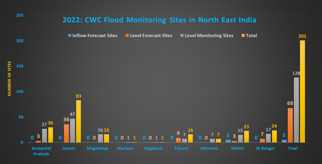
As of July 2022, the total number of flood monitoring sites have come down to 201 which includes 68 Level Forecast sites, 128 Level Monitoring sites and 05 Inflow Forecast sites. Out of 128 Level Monitoring sites 23 are either inactive or repeated. Excluding these would further bring down the number of active sites to 178. This is contrary to CWC’s claim of increasing flood monitoring stations in the country.
There is NO Level forecast site in 4 states of Meghalaya, Manipur, Nagaland and Mizoram while Sikkim has 5 Inflow Forecast sites. The analysis shows that CWC has been arbitrarily adding and removing flood monitoring sites in the region. Most of CWC’s hydrographs in the region are running late by several hours which has emerged as a new problem across the states in North East.
The specific issues and problems with flood monitoring sites have been mentioned in state wise manner above. In our 2019 analysis for North East India[V] we had highlighted some major gaps in CWC’s flood forecast in the region and most of these have remained unaddressed so far.
Summary Table of Level and Inflow Forecast, Monitoring Sites in North East India
| States | Level Forecast Sites | Level Monitoring Sites | Inflow Forecast Sites | Total | |||
| Active | Inactive | Active | Inactive | Active | Inactive | ||
| Arunachal Pradesh | 3 | 0 | 22 | 05 | 0 | 0 | 30 |
| Assam | 36 | 0 | 41 | 06 | 0 | 0 | 83 |
| Meghalaya | 0 | 0 | 14 | 02 | 0 | 0 | 16 |
| Manipur | 0 | 0 | 01 | 0 | 0 | 0 | 01 |
| Nagaland | 0 | 0 | 0 | 01 | 0 | 0 | 01 |
| Tripura | 09 | 0 | 04 | 03 | 0 | 0 | 16 |
| Mizoram | 0 | 0 | 02 | 05 | 0 | 0 | 07 |
| Sikkim | 03 | 0 | 14 | 01 | 05 | 0 | 23 |
| W Bengal | 17 | 0 | 07 | 0 | 0 | 0 | 24 |
| Total | 68 | 0 | 105 | 23 | 5 | 0 | 201 |
A SANDRP analysis (ht.sandrp@gmail.com)
End Notes:
[I] https://ffs.india-water.gov.in/main/site
[II] https://sandrp.in/2022/08/05/2022-cwc-flood-monitoring-sites-in-north-india/
[III] https://sandrp.in/2018/08/05/overview-of-cwcs-flood-monitoring-forecasting-in-north-east-india/
[IV] https://sandrp.in/2019/10/02/overview-of-cwcs-flood-forecasting-sites-2019-north-east-india/
[V] https://sandrp.in/2019/10/02/overview-of-cwcs-flood-forecasting-sites-2019-north-east-india/
