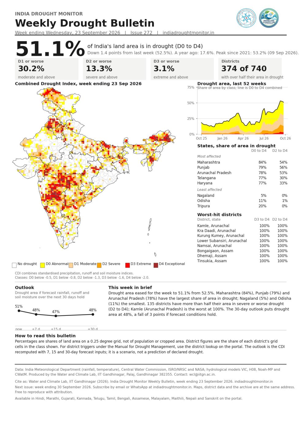
(Feature Image: Weekly drought monitor map dated 23 Sept. 2026 shows drought condition in India. Credit: Vimal Misra/ Drought Monitor India )
The DRP issue this week seems to have one central theme, connecting the various parts: Deficit monsoon leading to reduced reservoir levels, increased pollution, fish death and announcements of unprecedented droughts in more than one state. Since it was known to be a super El Nino Year and even IMD had predicted deficit monsoon, the ultimate deficit of 12.6% in SW Monsoon rainfall should in fact seem like bit of a relief. This was largely thanks to unexpected above average rainfall in the wettest month of SW Monsoon, July, largely due to favorable Indian Ocean Dipole.
Karnataka with 30% rainfall deficit has declared it to be the worst drought in 150 years. Maharashtra Chief Minister, has called the drought worse than that in 1972, when the state experienced the worst ever drought. Among the larger states Punjab has higher rainfall deficit of 41%, but less dependance on rainfall. North East India states have the highest deficit with Meghalaya at 60%, Manipur 46%, Arunachal Pradesh 44% deficit and Assam 28%, but these states have lower dependence on rainfall. However, lower reservoir levels in most states are another sign of worry.
But the fact that this situation was largely forecast and anticipated, raises a question: what did we do in anticipation of this situation? The answer practically, seems like: Nothing. Is there a lot we could have done? Yes, we could have acted in terms of suggesting farmers to take less water intensive crops and variety and could have facilitated the same. We could have created and asked communities to create more water harvesting, groundwater recharging facilities. These failures are bound to have repercussions.
More significantly, what actions are we taking now that the SW Monsoon is behind us, besides declaring drought in some areas? A number of things. For example, an emergency ecosystem wide monitoring network that over 200 ecologists recommended last week. IMD clearly needs to improve its forecasts at national, regional, state and district level forecasts, its forecasts of deficit turned out to be glaringly conservative and regional forecasts also erroneous. For the upcoming NE Monsoon and remaining year before the next monsoon, there is a lot that can be done for water conservation and demand side management.
DROUGHT 2026
Karnataka stares at worst drought in 150 years Karnataka has recorded its worst southwest monsoon rainfall deficit in 55 years, with rainfall from June 1 to Sept 30 falling 35% below normal, according to data from Karnataka State Natural Disaster Monitoring Centre (KSNDMC). The deficit is the lowest recorded since 1971, surpassing the previous low of 33% in 2002.
The state received just 551 mm of rainfall against the normal 852 mm during the four-month monsoon season. While rainfall improved in July and August, September saw a sharp reversal, with the state recording a 54% deficit during the month. According to KSNDMC data, in June 2026, the state recorded -42% deficit rainfall, which improved to -29% in July. In Aug, due to further improvement in rainfall, the deficit fell to -23%.
North interior Karnataka is the worst affected with -42% deficit rainfall, followed by south interior Karnataka, which recorded -41% deficit rainfall. Malnad region, comprising the four districts of Kodagu, Shivamogga, Hassan, and Chikkamagaluru recorded -38% deficit rainfall. The coastal region recorded -28% deficit rainfall.
Of the 31 revenue districts, Mysuru was the worst affected, with a 59% deficit, followed by Vijayanagara at 57%. Only Bengaluru South recorded rainfall within the normal range, with a deficit of 18%. Against normal rainfall of 419 mm, Mysuru received just 172 mm.
Karnataka estimates Rs 46,324 cr drought loss CM D K Shivakumar on Oct. 03 urged the Centre to provide Rs 7,142.64 crore in drought relief, saying farmers and the wider public were facing severe hardship. The revised demand comes after the state declared 177 taluks drought-hit and estimated losses at Rs 46,324.50 crore, according to a statement from the Chief Minister’s Office. The state had earlier sought Rs 3,705.30 crore from the Centre under National Disaster Response Fund norms. According to the statement, 217 of Karnataka’s 240 taluks have been identified as drought-affected, while 177 have been officially declared drought-hit. According to the statement, the state government has announced Rs 2,500 in relief for farmers, but is expecting greater help from the Centre.
Maharashtra to declare drought in 19 more talukas After being pushed by public representatives, the state govet, which has already declared drought in 74% of the state, is considering adding another 19 talukas to the list after a survey on 20% of five major crops in the taluka to assess losses. So far, drought has been declared in 265 of 358 talukas. At the first cabinet meeting after the declaration, several ministers, including Bhujbal, Shambhuraj Desai and Girish Mahajan had spoken out about other areas which needed to be included in the declaration.
For farmers in Sakri taluka of Dhule district, this year’s drought is not a story of the monsoon failing to arrive. It is about the rains arriving, raising hopes, and then disappearing when the crops needed them the most. Sakri is among the 265 talukas declared drought-affected by the Maharashtra government last week; the state has a total of 358 talukas. While the drought-hit areas cover 32 of the total 36 districts, all the four talukas in Dhule district are among the affected areas. The state recorded a rainfall deficit of 18% this year, with 798.2 mm of rainfall between June 1 and September 26, against a normal of 970.9 mm.
Forced to choose between profits from their produce and the immediate survival of their livestock, distressed farmers in drought-hit Latur district of Maharashtra are taking sickles to their standing sugarcane crops to feed hungry cattle amid a severe fodder crisis.
Railways ready to transport water Central Railway is open to running special water trains to drought-hit districts of Maharashtra if the state government provides an adequate water source. The railway zone has not yet received a formal request. With 265 of Maharashtra’s 358 talukas declared drought-hit, officials said the scale of the current situation could make the operation more challenging than the 2016 Latur water train.
Deficient monsoon leaves reservoirs under pressure Data from the Central Water Commission (CWC), which monitors 178 major reservoirs, shows that their combined live storage stood at 132.734 billion cubic metres (BCM) at the end of the monsoon. That represents 71.84% of their total live storage capacity and is substantially below last year’s 166.856 BCM. The current storage is also below the 10-year average of 151.118 BCM, signalling a weaker water position as farmers prepare for the winter crop cycle.
The situation is particularly concerning in the Cauvery basin, where deficient rainfall has increased water stress. Lower reservoir levels could intensify competition over water between Karnataka and Tamil Nadu, particularly as irrigation requirements rise during the Rabi season.
The CWC data shows that the problem extends beyond the south. The northern region, covering Himachal Pradesh, Punjab and Rajasthan, has 11 monitored reservoirs, all recording storage below both last year’s levels and their normal averages. The west, with 58 reservoirs, and the south, with 50 reservoirs, are similarly reporting storage below last year and normal levels.
The picture is mixed elsewhere. The central region, with 28 reservoirs, received relatively normal rainfall. Although its storage is lower than last year, levels remain above the long-term average. Eastern India presents an unusual contrast. Despite recording its lowest rainfall since 1901, according to the data cited, the region’s 31 reservoirs have more water than at the same time last year and remain above normal storage levels. The outlook could add to the pressure.
National Drought Summary: Sept. 30, 2026 The national drought situation this week shows a significant distribution across the drought classes. The cumulative area categorized as Normal was 52.6%, while the combined area experiencing drought conditions (D0+ and above) was 70.6% (47.4% for D0+ and 27.9% for D1+). The total area experiencing drought, specifically D0+ conditions, was 47.4% this week. This represents a contraction in the drought area, as the D0+ area decreased by 3.8 percentage points week-on-week, moving from 51.2% in the previous week to 47.4% this week. The most severely affected states, based on the percentage of their area in any drought class, include Goa at 100.0%, followed by Arunanchal Pradesh at 87.8%, Assam at 84.9%, Mizoram at 83.8%, Maharashtra at 82.4%, and Sikkim at 81.8%. Conversely, Odisha was the least affected state with 1.6% in drought.
MONSOON 2026
SW Monsoon 2026: District wise rainfall in India In the just concluded South West Monsoon 2026, India received 759.4 mm (937.2 mm in SW Monsoon 2025, 934.8 mm in SW Monsoon 2024, 820 mm in SW Monsoon 2023, 925 mm in SW Monsoon 2022) rainfall, about 87.4% (107.9% in 2025, 107.6% in 2024, 94.45 % in 2023, 106.5% in 2022) of the Normal SW Monsoon rainfall of 868.6 mm as per IMD. The 2026 SW Monsoon rainfall is 4th lowest since 2001 and first deficient monsoon since 2015. It is the 13th lowest rainfall since 1901. This rainfall is categorised as deficient rainfall since deficit is over 10%.
IMD’s district wise daily and cumulative rainfall figures as on Sept. 29, 2026.
Monsoon deficit at 13% Significantly, this is the fourth lowest seasonal rainfall since 2001 and the 13th lowest since 1901. Though India as a whole received nearly 13% less than normal rainfall, east and northeast India faced the highest deficit of 25%, followed by south Peninsula (24%), northwest India (6%) and central India (3%). Mohapatra said there has been a recent trend of east & northeast India consistently reporting decrease in rainfall.
Monsoon 2026 was widely expected to have a large rainfall deficit. However, even those casually interested in the monsoon would have noticed that there is wide geographic variation in its performance, with some regions quite wet.
Meghalaya Records 60% Rainfall Deficit The state received only 1,077.1 mm of rain compared to the normal average of 2,695.3 mm. Even Sohra and Mawsynram, globally recognized for their exceptionally high rainfall, recorded deficits of 36 per cent and 34 per cent, respectively. The unusual decline in precipitation has heightened concerns over water availability across the state.
Meghalaya had the highest rainfall deficit throughout SW Monsoon 2026 Meghalaya is facing its highest-ever monsoon rainfall deficit in 2026 and 10 of 11 districts classified as deficient or largely deficient. This emerging drought-like situation threatens agriculture, water security, and spring-fed drinking supplies, compounding long-term trends of declining monsoon rainfall and climate stress. A 30 year (1989-2018) analysis of monsoon rainfall data in Meghalaya by the IMD showed a significant decreasing trend in monsoon rainfall during the period.
Himachal records 41st lowest monsoon rainfall since 1901 The IMD said the southwest monsoon seasonal (June to September) rainfall was normal over the state, with 652.3 mm of actual rainfall against the normal 734.4 mm, reflecting a departure of minus 11 per cent. This year, Himachal Pradesh recorded the 41st lowest monsoon rainfall of 652.3 mm during the monsoon season in the last 125 years. However, the highest rainfall of 1,314.6 mm was recorded in 1922 during the period from 1901 to 2026. The IMD said Himachal Pradesh received normal precipitation, with a departure of minus 17 per cent, recording 212.5 mm of actual rainfall against the normal 256.8 mm rainfall in August.
HYDRO POWER PROJECTS
Residential colony of Rimbi HEP in Sikkim Washed away Residents of Rimbi, a village in Gyalshing district, are staring at an uncertain future as they look back at their devastated village. A devastating landslide struck the village on the night of September 24, 2026, forcing residents to evacuate their homes. Sonam Sherpa, a resident of Rimbi, said that more than 30 houses are either at risk or have been completely destroyed. “The residential colony of the Rimbi hydropower project was swept away. Apart from the colony houses, several other houses in the village have also been affected to such an extent that they are no longer habitable. Mud and debris have filled the houses, and the villagers have been evacuated.”
Sonam added, “There is a stream that got blocked due to the landslides and eventually got redirected towards Rimbi village, carrying a huge load of mud, debris and large boulders.” For Sonam and others in Rimbi, the question that looms largest is whether their village will ever again be habitable. As per the IMD data, Yuksom recorded 224.6 mm of rain during the 24 hours from 9.30 am on September 24 to 9.30 am on September 25, which is a large amount. But is it the only factor that contributed to the devastation?
SUMP: Govt invites SIFF for talks After a massive show of opposition to the pre-feasibility report study of the Siang Upper Multipurpose Project during Chief Minister Pema Khandu’s recent visit to the Upper Siang and Siang districts, the government has written to the Siang Indigenous Farmer’s Forum (SIFF), inviting them to a meeting in Pasighat. The meeting is to be held at Pasighat in East Siang on 5 October in the afternoon, according to the letter. Meanwhile, the government has withheld at least two Facebook accounts that are critical of the government’s plan to go ahead with the SUMP PFR. One of the accounts belongs to activist Ebo Mili, a vocal critic of the government.
APCC forms Fact Finding Team to assess SUMP The Arunachal Pradesh Congress Committee (APCC) on Sept 27 2026 formed a fact-finding panel to evaluate areas that could be affected by the proposed 11,000-MW Siang Upper Multipurpose Project (SUMP). APCC president Bosiram Siram announced, “The issue of mega hydropower projects must not be viewed solely through a political lens. It directly concerns ‘jal’, ‘jameen’, jungle, ‘jati’ (water, land, forest, and identity) and our collective existence as indigenous communities,” Byaling said.
APCC working president Tanga Byaling will head the committee, with senior leader Takam Sanjoy as vice-chairperson and Tami Pangu as member secretary. Daniel Gao and Johny Yangfo will be members. According to a party statement, the panel will conduct village-to-village visits across East Siang, Siang and Upper Siang districts to assess the project’s social, environmental and livelihood impacts. It will document grievances related to land acquisition, rehabilitation and local security arrangements & submit a report in 15 days.
Subansiri Dam changed the debate on rivers & development The Lower Subansiri dam was built to deliver energy and development. Decades of resistance reveal deeper questions about river ecology, livelihoods, participation, welfare and how infrastructure gains legitimacy.
Kashmir’s Hydropower Paradox: Resource Rich Region to Energy dependent Economy The debate over Jammu and Kashmir’s hydropower resources is entering a new and perhaps more consequential phase. For years, the argument centred on projects already operating under NHPC ownership and whether some of them, particularly Salal, Uri-I and Dulhasti, should be transferred or bought back. The question now extends to projects being built today and the ownership arrangements that will govern them for much of this century. Three new projects, Sawalakot, Uri-I Stage-II and Dulhasti Stage-II, have been entrusted to NHPC under a 40-year Build, Own, Operate and Transfer, or BOOT, arrangement. Together, they will add 2,356 megawatts of installed capacity, with Sawalakot accounting for 1,856 MW, Uri-I Stage-II for 240 MW and Dulhasti Stage-II for another 260 MW.
The agreement for Sawalakot was signed in December 2021, while those for Uri-I Stage-II and Dulhasti Stage-II were signed in March 2026. Under the arrangement disclosed by the government, these projects are to be handed over to J&K after 40 years from the commencement of commercial operations. There is an obvious improvement here over an arrangement with no defined transfer mechanism at all. Nevertheless, it produces a striking contrast. While there is currently no proposal to take back the existing 2,250 MW of NHPC capacity, another 2,356 MW is being developed under a structure in which NHPC will own and operate the projects for four decades before transferring them to J&K.
Ultimately, the true measure of hydropower wealth is not simply the electricity generated by a river, but how much lasting economic value remains in Kashmir after that electricity has been generated and sold. (Dr Mubeen Ahmed Shah)
HP Govt ready to take over SJVN’s Dhaulasindh Project CM Sukhvinder Singh Sukhu on Sept 30 directed the Power Department to file an affidavit in court for taking over the 66-MW Dhaulasidh Hydro Power Project being constructed by SJVN on the Beas River. Sukhu said the state government was ready to pay the first instalment towards the project cost to facilitate its takeover in the interest of Himachal Pradesh. The Chief Minister said earnest efforts were also being made to take over the Luhri and Sunni hydro power projects from SJVN.
Officials informed the Chief Minister that the 450-MW Shongtong HEP would become fully operational by September 2027 after commissioning of its remaining three turbines. A power purchase agreement would also be signed with the Himachal Pradesh State Electricity Board Limited for the electricity generated by the project.
DAMS
Polavaram: Chhattisgarh tribals in limbo for violations, lack of survey Polavaram Project on Godavari River leaves villages in the neighbouring Chhattisgarh in fear about displacement, because of uncertainty about the project’s submergence area. Different government records cite different numbers of potentially affected villages in Chhattisgarh, leaving residents unclear about their residence. There has never been proper survey, the number of affected villages vary from 4 to over 18.
Himanshu Thakkar of SANDRP, told Mongabay-India, “It is a complete violation of the law, the way Andhra Pradesh is going ahead with the project, and in fact, the environmental clearance for the project was suspended. It is still suspended.” Thakkar’s reference to the suspension of environmental clearance relates to the Ministry of Environment and Forests’ February 2011 stop-work order. The ministry had directed Andhra Pradesh to stop work over the project’s environmental-clearance conditions, including the requirement for public hearings in Odisha and Chhattisgarh. The stop-work order was subsequently kept in abeyance for more than a decade, allowing construction to continue, while the questions over environmental clearance and interstate submergence remained unresolved.
Thakkar said, “There should have been a public hearing, where affected people should have been given the opportunity to participate so they could express their views. Certain areas in Chhattisgarh, Odisha, and Telangana are also set to be submerged. In addition, the backwater impact has not been assessed. There have also been violations of the Forest Rights Act (FRA). There have been violations of many things, and neither the state nor the central government should allow the project. But they are allowing the project to go ahead”. He said, “In fact, even the judiciary has not taken any effective steps.”
Polavaram: Telangana urges MoJS to expedite drainage congestion studies The Telangana government on on Sept 25 urged the Jal Shakti Ministry to expedite the drainage congestion studies in order to protect Bhadrachalam from submergence in the backwaters of the Polavaram project of Andhra Pradesh. In a letter to the Jal Shakti Ministry, Telangana Irrigation Secretary E Sridhar urged the Centre to finalise the demarcation of submergence areas and initiate protection measures through embankment construction, land acquisition and pumping arrangements.
Telangana plans end to end Diaphragm wall for Medigadda Barrage The rehabilitation of the Medigadda barrage of the Kaleshwaram project is likely to include an end-to-end diaphragm wall to provide foundation protection, Telangana irrigation minister Uttam Kumar Reddy said on Sept 27 2026. The strengthening and extension of downstream stilling basins would be required for all three barrages — Annaram, Sundilla and Medigadda to reduce the velocity of floodwaters and improve energy dissipation. These are being considered based on a preliminary examination of the extensive technical tests conducted at the three barrages. “The final design report is expected within two or three weeks. We are planning to begin the rehabilitation works in Nov or, at the latest, Dec and complete them by June 2027, before the next monsoon,” he said.
Army Officers to be deployed to strengthen SLBC, repair Kaleshwaram Barrages For speedy completion of the Srisailam Left Bank Canal (SLBC) works and rehabilitation of the three Kaleshwaram barrages, the Telangana govt has engaged three additional officers from the Indian Army’s Corps of Engineers.
Sardar Sarovar full for the 7th time since 2017 The Sardar Sarovar Dam in Narmada district, reached its Full Reservoir Level (FRL) of 138.68 metres on Sept 30 evening. The water-resources data shows an overall deficit in Gujarat of about 3,800 MCM or 24.13% lower as compared to the figures last year. The dam did not reach FRL in 2017, 2018 and 2021.
The govt said 201 million cubic metres Narmada water had been supplied under the Sujalam-Sufalam scheme during the current water year, helping fill 1,028 lakes. Under the SAUNI scheme, 288 MCM was supplied to fill 167 lakes, 1,014 check dams and 45 dams.
Villagers Oppose Kishau Dam’s Height, Location Villagers from Jaunsar-Bawar and Himachal Pradesh unanimously decided at a mahapanchayat in Kwanu that they are not opposed to the Kishau Dam itself, but to its proposed height and location. They demanded that the dam be shifted further towards Meenas from the currently proposed site. They vowed that they would not allow Kwanu to be submerged at any cost. The mahapanchayat witnessed strong protests over the dam’s proposed height and location. Ground Report
Majhgawan Villagers Demand Compensation & Rehabilitation The movement by tribal and other families falling in the submergence area of the Majhgawan Medium Irrigation Project continued for the 21st day on Oct. 02. Families affected by the Majhgawan project say that the biggest question before them is that of the future.
The families whose land and homes are falling in the project’s submergence area want to know where they will be settled after displacement and what the complete arrangement for their rehabilitation will be. Protesters say that until every eligible family gets its legal right, the movement will not be ended. Houses in Tapariya, Madaliya and Kunwarpur villages of Ajaygarh were demolished without compensation. Rehabilitation has remained pending for eight years.
INTERSTATE WATER DISPUTES
As Ganga treaty review nears, Bihar looks beyond Farakka The Patna dialogue highlighted a fundamental point: Bihar’s water crisis is a basin problem, not a barrage problem alone. Farakka may remain an important part of the debate, but the State’s future water security depends on a much larger framework—Himalayan catchments, Nepal, upstream abstraction, tributary flows, sediment management, groundwater, floodplain management, navigation and ecological sustainability. The challenge before Bihar is therefore to move from episodic political demands towards a long-term basin strategy backed by credible data and scientific evidence. The December review of the Ganga water-sharing arrangement should not become merely another contest between competing claims. It could instead provide an opportunity to build a more transparent and cooperative institutional framework for the Ganga basin. For Bihar, the larger demand is not simply for more water. It is for a meaningful voice in decisions that determine the quantity, timing, quality and ecological health of the river on which much of its economy and society depend. (Kumar Krishnan)
URBAN RIVERS
Ulhas river turns turbid The Ulhas River, a major source of drinking water for nearly 50 lakh residents across Thane district, has turned unusually red and highly turbid in recent days, prompting environmental activists to investigate possible source of change along its upper reaches in Karjat. Members of the Ulhas Bachao Kriti Samiti conducted a two-day inspection at 28 locations between Kalyan and Karjat. They documented hill cutting, tree felling, soil filling, construction activity and silt entering the river and its tributaries.
The activists identified Pimploli near Karjat as a key area of concern, where they observed extensive hill cutting and tree felling along the Chillar river near a large plotted development project. They suspect exposed red soil and loose earth may have been washed into the Chillar during recent heavy rainfall and subsequently entered the Ulhas. The team also inspected areas around the Kondana caves and along the Page River, where construction activity was observed. Activists have sought an assessment of whether soil or construction material from these sites entered water channels during rainfall. However, the committee stressed that its observations are preliminary and require scientific testing and an official investigation.
Musi RFD: Govt announced separate land-pooling terms for the Musi Riverfront Development Area, with the exercise initially proposed between Nagole and Gowrelly. The total area to be pooled, according to MRDCL director Narasimha Reddy, is still being worked out. Patta landowners will get either a 50:50 share of developable land or 1,400 sq. yards per acre, whichever is less, after development.
RIVERS
Brahmani and Baitarani basins show signs of rising heat and water stress A recent study by Dibya Jyoti Mohanty & Jajnaseni Rout in Geocarto International uses satellite data to investigate temperature trends within the BBRB river basin from 2000 to 2022, focusing on its significant industrial, mining, and agricultural centres and the contribution of anthropogenic pressures to temperature changes. The findings offer a picture of a basin that is becoming warmer, while its water cycle is also changing.
The study found an upward trend in evapotranspiration across the basin between 2000 and 2022, increasing by around 5.5 kg per square metre each year. The authors link the increase in evapotranspiration to rising temperatures and changes in land use and land cover. As vegetation, cropland, built-up areas and exposed surfaces change, so too can the way water is stored, used and returned to the atmosphere.
At the same time, river discharge has been declining. Data from the Jenapur station on the Brahmani River shows a downward trend in river flows. The combination of rising temperatures, increasing evapotranspiration and declining river discharge points towards growing water stress in parts of the basin. The study points towards measures that address temperature, land use and water together: Reforesting and restoring wetlands, Regulating mining and industry, Promoting sustainable agriculture, Introducing urban cooling measures, Involving communities.
Yadgir industries face probe over Bhima river pollution The Karnataka govt has ordered an inspection of industries in Yadgir’s Kadechur-Badiyal industrial area after villagers alleged that untreated industrial wastewater was being discharged into open drains and eventually reaching the Bhima River. The complaints concern an industrial area where more than 50 companies are reportedly operating. Villagers say wastewater from chemical and pharmaceutical units is affecting crops, animals and water sources in surrounding villages.
The complaints have raised concerns among residents about the effect of industrial discharge on agriculture and the local water supply. Villagers have sought a comprehensive inspection of the industrial units, scientific analysis of wastewater samples and action against companies found to be violating environmental rules. The administration’s inquiry will determine whether wastewater from the units entered nearby drains and the Bhima River and whether the companies complied with requirements for treating industrial effluent before discharge.
Telangana citizens demand baby ponds to save Godavari Every year, thousands of Ganesh idols are immersed in the Godavari in Nizamabad district. While Hyderabad has introduced temporary immersion ponds and designated facilities to minimise pollution from idol immersion, no similar arrangements appear to have been made along the river in Nizamabad. Yancha in Navipet mandal and Ummeda in Nandipet mandal are among the major immersion points in the district. Idols are also reportedly immersed at several other locations along the river.
BBN locals protest industrial pollution Residents of the Baddi-Barotiwala-Nalagarh (BBN) industrial belt staged a protest in Nalagarh on Sept. 30 against alleged air and water pollution and excessive groundwater extraction by local industries, demanding an independent scientific investigation into the region’s environmental problems.
Protesters said unplanned industrialisation and inadequate regulation had put pressure on groundwater, surface water and air quality in the belt. They alleged that ethanol and distillery plants were being installed despite water scarcity and could further deplete groundwater. They also raised concerns over Chikni Khad, Mahadev Khad and the Sirsa river, alleging pollution from industrial effluents and sewage. The memorandum sought mapping of drains and factory discharge points and independent testing of groundwater, surface water, air, soil and industrial effluents through NABL-accredited laboratories.
Himalaya Niti Abhiyan convener Guman Singh has also raised questions about the capacity and operation of the CETP at Kenduwal in Baddi. He alleged that some industries are discharging untreated waste into local drains and watercourses or injecting it into groundwater through illegal reverse borewells. The latest controversy comes against the backdrop of government monitoring that has also shown severe pollution in the Sirsa. Earlier PPCB monitoring data for July 2025 to March 2026 showed substantial variation and elevated levels of several pollution indicators near Ghanauli, including extremely high total and faecal coliform counts.
With the Sirsa ultimately discharging into the Sutlej, environmentalists have stressed that contamination originating in the Himachal industrial belt was reaching every nook and corner of Punjab through the Sutlej and canal systems emerging from the river.
SC gives 8 weeks to clear floodplain encroachments in Patna A bench comprising justices J B Pardiwala and K V Viswanathan issued a stern warning, stating that failure to meet this definitive deadline would result in the summoning of Bihar’s chief secretary along with other top officials, potentially triggering contempt of court proceedings. The bench noted that the court had, on July 21, granted the state six weeks to ensure that every unauthorised structure and encroachment standing on the stretch was cleared.
During the Sept 28 hearing, Bihar’s advocate general Satya Darshi Sanjay informed the bench that the court’s orders had only been partially implemented. He cited a recent natural calamity in Nepal that caused the Ganga’s water levels to surge, submerging the specified stretch and temporarily halting demolition and clearance operations. The Supreme Court was hearing a petition that challenged a June 2020 order by the NGT. The NGT had previously dismissed a plea targeting illegal permanent constructions on these vulnerable floodplains.
Sonbhadra charts plan to revive Lauwa river An action plan for the revival of the Lauwa river in Sonbhadra district was presented at the Indian Institute of Technology, Banaras Hindu University, Varanasi, on the occasion of World Rivers Day. The presentation was held under the “One River, One Initiative” programme of the State Clean Ganga Mission. Selected district project officers from across Uttar Pradesh presented river revival plans for their respective districts.
SC panel finds sewage from UP biggest contributor to Yamuna pollution Headed by the Union home secretary, the six-member committee found that an estimated 7,999 MLD of domestic sewage is generated in the Yamuna catchment across five states along its course – Uttarakhand, Himachal Pradesh, Haryana, Delhi and UP. Of this, 6,243.83 MLD is currently treated, leaving a treatment gap of around 22% (1,756 MLD is untreated). Across the Yamuna basin, 520 major drains empty into the river. UP’s treatment gap for sewage is 34% and for wastewater (non-sanitary effluent) is 63%.
Industrial pollution remains concentrated in clusters. Around 6,300 water-polluting industries operate in the catchment. To address the issue, the committee has proposed investments of more than Rs 20,000 crore in sewage treatment infrastructure to reduce pollution loads, improve environmental flow, restore aquatic ecosystems and ultimately rejuvenate the river.
DJB approves ₹17,969cr sewer overhaul plan Under the 10-year “One Zone, One Operator” model, each operator will be responsible for the repair, maintenance and management of all sewer infrastructure in its zone, including sewer lines, manholes, pumping stations and consumer complaints. The model, senior DJB officials aware of the matter said, is similar to the power distribution system, under which four providers operate in four zones of Delhi.
The board also approved the tenders for 13 new STPs with a combined capacity of 328 MGD, at an estimated cost of ₹7,373 crore under funding from the NMCG. An Asian Development Bank top-up loan of ₹3,505 crore was also approved for a further 60 MGD sewage treatment plant, transmission upgrades, SCADA systems and distribution improvements. The DJB also approved the Delhi Water & Sewer (Tariff and Metering) Regulations, 2026, replacing the 2012 regulations.
Also, the DJB board also approved a ₹6,044.05-cr project for a comprehensive overhaul of the water supply infrastructure in south Delhi. It will introduce smart meters, bulk flow meters, and chlorine and pressure sensors to enable real-time monitoring, more accurate metering and water auditing.
Yamuna to be surveyed for rejuvenation works Delhi govt has started the process of conducting detailed topographical and bathymetric surveys along the river from Palla in north Delhi to Jaitpur in south Delhi before taking up large-scale dredging work. The topographical survey will map the land, riverbanks and floodplain, while the bathymetric survey will measure the depth and shape of the riverbed underwater. The survey by Irrigation and Flood Control Department will show a detailed picture of what exists on the ground and under the water before any major excavation is undertaken. The information will help identify areas where the riverbed has changed, where sand deposits have accumulated and where dredging may be required.
7 new STPs to check Yamuna pollution in Karnal The Haryana State Pollution Control Board, Karnal Municipal Corporation (KMC), Public Health and Engineering Department (PHED) and other departments are working together to prevent untreated wastewater from entering the river.
Karnal district currently has 14 STPs with a combined capacity of 130 MLD. A 2-MLD STP is being constructed at Barsat by the PHED, with 70% of the work completed, planned to be commissioned by the year-end. A 1.5-MLD STP at Nigdhu has been completed, while work is under way on a 0.8-MLD plant at Karna Canal said ADC Rahul Raiya.
The KMC will construct 2 more STPs – a 15-MLD plant adjoining the existing 50-MLD STP in Sector 4 and an 8-MLD plant adjoining the existing 8-MLD STP in Shiv Colony. Tenders for both are under evaluation. The PHED will set up 5 mini STPs at Shekhpur Khalsa Malikpur, Halwana, Khora Kheri, Dholakua Bras and Narayana, targeting drains/ nullahs flowing towards the Yamuna.
2 HSPCB officers suspended after CM review Two senior pollution control officers in the city were suspended after a citizen complaint over the improper operation of a STP by a builder was reviewed at the highest level. The regional officers for Gurgaon (north), Akansha, and south, Mukul Kumar, were suspended with immediate effect. Separate orders were issued by HSPCB chairperson Shekhar Vidyarthi. The action came after CM himself reviewed complaints filed by residents through various channels on Oct. 02.
Ujjain’s Siddhavat Ghat water unfit even for ritual sipping The August report of the Madhya Pradesh Pollution Control Board (MPCB) also confirms the poor condition of Shipra’s water. The water at Siddhavat Ghat was found to be ‘NOT SATISFACTORY’ for the second consecutive month. In 2026, a joint committee of the NGT inspected 14 drains in Ujjain.
According to religious belief, Siddhavat holds special significance. According to Pandit Trivedi, Chapter 49 of the Avantika Khanda of the Skanda Purana states that the Shipra originated from Lord Vishnu’s index finger, while the Ganga originated from his feet. As the Shipra flows northwards, it is believed to be ten times more spiritually meritorious than the Ganga.
RIVERS BIODIVERSITY
Kaziranga ESZ: What changes with a smaller buffer? The conversation with Ritwick Dutta, LIFE looks at the legal process for changing Kaziranga’s ESZ, the concerns of communities around the park & the importance of areas outside the national park that are used by wildlife. We also examine what a narrower ESZ could mean for development and tourism around Kaziranga, as well as concerns over mining and quarrying in the wider Kaziranga-Karbi Anglong landscape.
Gorai Creek yields rare sighting of dog-faced water snake covered in algae Independent researcher Rahulratan Chauhan spotted the sluggish reptile on February 11, 2025, during a routine cycling trip near Borivli. According to Chauhan, the snake was safely captured, photographed, and subsequently released. The observation, published in the scientific journal Zoo’s Print, marks the first recorded instance of algal fouling in Mumbai, and the first recorded instance in India involving this particular species. Algal fouling occurs when algae attach to a submerged animal and grow on its body. The phenomenon has previously been documented on animals such as sea turtles and some sea snakes.
FISH, FISHERIES, FISHERFOLKS
Project to rid Ujani dam of invasive fish species The BNHS is helming the Ujani Wetland Eco-restoration and Fisheries Development Program, the first such initiative in South Asia to involve local communities in removing invasive fish such as suckermouth and reintroducing indigenous fingerlings into the Ujani. The BNHS is also working to get the dam notified as a Ramsar site, which would give the ecosystem a higher level of protection. Meanwhile, the administration is cracking down on illegal Mangur farming.
Alongside eliminating invasive fish species, the Ujani project will reintroduce indigenous fish and plants. By January 2027, around 4.2 million fingerlings of native species such as Deccan mahseer, rohu and catla will be released, along with endemic and endangered varieties like Bobri, Kolshi and Khavlya. In 2027, around 60-70 million spawn will be introduced. According to Katwate, reintroducing endemic and previously lost fish species will create competition for ecological niches between them and invasive species.
Hundreds of fish found dead in Banganga Tank Hundreds of fish have been found dead in the historic Banganga Tank in Walkeshwar, South Mumbai, drawing attention from local residents and environmentalists. The Brihanmumbai Municipal Corporation (BMC) has called a meeting with local residents and priests on Oct. 05 to discuss measures following the fish deaths. The meeting will be held at the civic body’s D ward office.
The civic body has stepped up cleaning operations and plans to increase manpower at the tank. It has also installed an aeration pump and will undertake pumping out and refilling of the tank. The BMC has sent water samples for testing following the fish deaths. The issue has occurred previously. In 2025, the BMC removed around 10,000 kg of dead fish, floral waste and other organic material from Banganga over three days.
After Mula, mass fish deaths spotted in Indrayani Sept. 15 report on mass fish kill in Indrayani river near Alandi temple, raising fresh concerns over the region’s spiralling river pollution. The dead fish were discovered just meters away from Alandi temple, a prominent pilgrimage site that draws hundreds of thousands of devotees from across Maharashtra. Environmental activists stated that such incidents have become alarmingly frequent, alleging that local authorities have failed to curb illegal discharge of pollutants into the water.
Prashant Raul of Green Army environmental group spotted the dead fish during a visit to the riverside on Sept. 12. He noted that despite reporting similar incidents to the authorities in the past, no concrete improvements have been made. “Untreated effluent entering from Pimpri-Chinchwad Municipal Corporation (PCMC) limits through Ram Zara nullah, combined with sewage from upstream villages, is the primary driver of pollution in Indrayani,” Raul said.
Dead fish surface in the Indrayani River Residents and environmental activists have expressed concern after dozens of dead fish were found floating in the Indrayani River near Dehu on June 13, once again drawing attention to the river’s worsening pollution ahead of the annual palkhi procession of Sant Tukaram Maharaj. The incident comes just weeks before thousands of warkaris are expected to gather in Dehu for the Ashadhi wari pilgrimage. The palkhi is scheduled to leave for Pandharpur on July 7.
Dinkar Jadhav, a local resident said a similar incident was reported last year and alleged that inadequate river-cleaning efforts had allowed large stretches of the river between Yelwadi and the Gatha Temple to become clogged with water hyacinth.
Nira river mass fish deaths As per this April 06, 2026 report he discovery of a large number of dead fish in the Nira river over the last two days sparked widespread concern among villagers of Baramati tehsil. Preliminary findings are pointing to industrial pollution, prompting villagers to accuse the MPCB of failing to act despite repeated warnings.
Kartikeya Langote, who heads the sub-regional MPCB office in Baramati, said early indications suggest the discharge of untreated industrial effluents into the river. The incident has triggered sharp reactions from villagers, who depend on the Nira river for irrigation and daily use. Residents from nearly 20 villages said the latest episode is part of a recurring pattern of pollution that has steadily degraded the river over the years.
Dead fish pile up in Cauvery bank As per July 29 report, thousands of fish have been found dead along the banks of the Cauvery river near Amma Mandapam in Trichy over the past few days. Officials suspect the deaths resulted from critically low water levels due to the absence of releases from the Mettur dam. The stretch of the Cauvery flowing through Trichy city between the Upper Anaicut (Mukkulathor Barrage) and the Grand Anicut (Kallanai Barrage) is dry in most places, with only stagnant water remaining in a few stretches at extremely shallow depths.
Under these conditions, several thousand fish have been dying after struggling for breathe along the riverbanks near Amma Mandapam in Srirangam. A fisheries department official stated, “The fish could be dying from insufficient oxygen or from overwhelming pollution. We are investigating the circumstances.” Meanwhile, activists have called on the state government to take measures ensuring the flow of Cauvery river water as early as possible to prevent further loss of river fauna.
Mass fish death as Tungabhadra runs dry This July 19 report mentions death of thousands of fish in the Tungabhadra River as water flow has reduced drastically due to deficient rainfall, raising concerns over the deteriorating river ecosystem in parts of Koppal district. The riverbed near Kakkaragol and Nandihalli villages in Siddapur hobli of Karatagi taluk has nearly dried up, leaving behind scattered pools of stagnant and muddy water.
Villagers and environmental activists criticised the authorities for failing to maintain a minimum flow in the river from the Tungabhadra reservoir. They warned that unless water is released immediately, the region could face a drinking water crisis in the coming days. Vishnutirtha Joshi, local convener of the Save Tungabhadra campaign, urged the authorities to release water from the Tungabhadra reservoir and ensure a minimum flow in the river during the monsoon season.
Fish kill along Phalguni A fish kill was reported on June 06 along the Phalguni river near Bengre, Sulthan Battery and Bokkapatna, locals said, days after environmental activists flagged pollution and demanded the removal of a temporary coffer bund built for a bridge between Tannirbhavi and Sultan Battery. Locals have alleged that rising pollution levels, caused by the coffer bund obstructing water flow, led to fish deaths. Many residents have also complained of rashes and irritation upon contact with the water. According to locals, a portion of the coffer bund was reportedly removed on June 06.
Gurupura fish kill Residents living along stretches of the Gurupura River near Kenjar and downstream of the Maravoor vented dam have begun getting their well water tested following the recent mass fish deaths reported in the area. Regarding the fish death incident, Fernandes said preliminary findings by the KSPCB suggest a malfunction at the Panchanady STP. Samples have also been collected from the spot where fish were found dead. Residents have been advised to check their water analysis reports for the presence of E. coli bacteria, which indicates faecal contamination.
Dead fish found floating in Paradip river Hundreds of dead fish were found floating in the Kapiljora river near Paradip in Jagatsinghpur district on April 12 morning, prompting officials from OSPCB to visit the site and collect water and fish samples to determine the cause of deaths. Many locals gathered near the river to collect the dead fish, while others alleged that industrial pollution in Paradip was responsible for the incident. The OSPCB officials blamed the locals.
Fish die in Teesta Hundreds of fish floated dead on the Teesta river near Jalpaiguri town on April 29, 2026 raising concerns that anti-social elements had poisoned the water. Residents of South Sukantanagar noticed the dead fish while heading to the riverbank with their cattle on Tuesday. They claimed that nearly 10 varieties of fish were found floating lifeless in the water.
Many residents suspect that the deaths were caused by deliberate poisoning of the river. In February, a large-scale fish death was reported along a stretch of nearly 1.5km of the Karala, which flows through Jalpaiguri town.
NGT seeks report over fish deaths in Subarnrekha River The order was passed by a Bench comprising Justice Sheo Kumar Singh, Judicial Member, and Expert Member Ishwar Singh on May 20. The matter is scheduled for further hearing on August 10, 2026. The case concerns the worsening condition of the Subarnarekha River, highlighted by an incident reported on April 1, 2026, when hundreds of dead fish were allegedly discovered floating near Babudih Lal Bhatta in Jamshedpur. Residents in the area also complained of a strong foul odour emanating from the river, raising serious concerns over water contamination, environmental degradation, and potential risks to public health.
Expressing concern over the death of large quantities of fish in Subernarekha river, Jamshedpur (West) MLA Saryu Roy on April 02, 2026 directed the local administration to clean the waste which has been dumped in the river. Roy inspected the river in Babudih area of the Steel City following reports about the death of large quantities of fish over the past few days. Demanding a probe, Roy said, “The death of fish must be probed as Subarnarekha and Kharkai rivers which flow by Jamshedpur and serve as lifelines to 15 lakh people of the city.”
SAND MINING
How Unchecked Sand Mining Is Ruining Indian Rivers What renders this crisis particularly insidious is its human toll, a dimension that remains dangerously underreported and poorly quantified. Beyond environmental degradation, illegal and unsustainable sand mining contributes to avoidable violence, deadly confrontations between enforcement agencies and illegal operators, and fatal accidents involving workers, transporters, and local residents.
Collapsing riverbanks, submerged excavation pits, and overloaded vehicles claim scores of lives annually, yet no comprehensive national database or systematic assessment of this man-made disaster exists. SANDRP has documented numerous incidents, but the full scale of human suffering remains obscured. (CP Rajendran)
Dumper crushes forest ranger stopping illegal sand mining A forest ranger was killed in Rajasthan’s Pratapgarh district after he was allegedly struck and dragged by a dumper while attempting to stop illegal mining activity, officials said. The incident took place late Monday night in the Chhoti Sadri forest area, where Forest Ranger Pratap Singh Chundawat had reached along with a forest guard following a tip-off about unauthorised mining.
A major accident occurred at a crusher in Bathri village, Haroli, Una, Himachal Pradesh, when a tipper lost control and overturned onto temporary shanties below. A 40-year-old woman, Rinki, and her six-year-old daughter, Komal, both from Bihar, were crushed to death. The family was temporarily living there, while the father worked at the crusher. The tipper driver fled the site after abandoning the vehicle.
RAMSAR WETLANDS
Chilika: Caught in the crossfire For generations, the life of Chilika beat in time with the monsoon, the rivers & the sea. Today, that rhythm has been profoundly disrupted by erratic rainfall, extreme weather & rising temperatures. At the same time, intense fishing pressure, pollution, unregulated tourism & aquaculture are placing unprecedented strain on Odisha’s iconic brackish-water lagoon and threatening the livelihoods of the communities who depend on it.
WATER OPTIONS
Does India Have Enough Water? This video from The Migration Story looks at 3 water conservation success stories and the communities that made them possible. India is a water-stressed country, and with the 2026 monsoon being drier than normal, more than 50% of the country is facing drought conditions. Can community efforts scale beyond the local impact to a more national solution? In conversation with Himanshu Thakkar of SANDRP.
Can runoff be harvested to meet cities growing water demands? A recent study by Indra Mani Tripathi and others, published in Sustainable Cities and Society: Advances, examines this possibility in three cities with very different climates: Bhopal, Bhuj and Kozhikode. Using the Soil and Water Assessment Tool, the researchers carried out a comparative water budget to assess how much runoff could potentially be harvested to strengthen urban water security. The three cities tell very different stories.
Putting the three cities together shows why urban water management cannot follow a single model. Bhopal has substantial runoff potential, estimated at 134,275.01 ML per year, but limited groundwater recharge and significant evapotranspiration. Bhuj has much less runoff, at 6,586.23 ML per year, but faces severe water scarcity after its short monsoon. Kozhikode receives much more rainfall and has a runoff potential of 69,646.21 ML per year but must also manage flooding.
The comparison points to the importance of understanding water at the city level. For Bhopal, capturing a portion of the large volume of runoff could help address the gap between supply and demand. For Bhuj, storing monsoon runoff could help carry water into the long dry season. For Kozhikode, runoff harvesting could contribute to non-domestic water needs, help manage floods.
The study therefore advocates tailored runoff harvesting systems as a way to improve urban water self-sufficiency. The lesson from these three cities is not that runoff can replace existing water sources. Rather, understanding where rainwater goes, how much is lost and how much could potentially be captured gives cities another way to plan for their water needs.
Conclusion This study successfully demonstrated the utility of detailed water budgeting, using the SWAT model, as a critical tool for assessing water management challenges and opportunities in three Indian cities representing diverse climatic zones. Using Bhopal (subtropical), Bhuj (arid), and Kozhikode (humid tropical) as test cases, this research developed water-sensitive urban design strategies.
GROUNDWATER
Ethanol, AI And Agriculture: Who Has Right To India’s Depleting Groundwater? The fix does not require new machinery. It requires the political will to balance development with the competing demands being placed on groundwater. We have the Ministry of Jal Shakti’s own data identifying where groundwater depletion is most severe. We also have government data showing where ethanol plants and data centres are being developed. Overlay the two, and a map of India’s most vulnerable collision zones emerges.
India has the maps, the monitors and the institutions. What it lacks is the wiring between them. Without it, the country risks building its next growth engine on the very resource it is quietly draining—and discovering, one over-exploited block at a time, that it cannot make ethanol, run a data centre or grow a crop on ground that has already given up its water. (Dil Prithviraj Sen & Aakash Shirudkar)
INDUSTRIAL WATER USE
7 Bn Ltrs Ethanol Glut looks for new buyers India has annual Ethanol production capacity of 20 Billion Litres with another 4 Bn Ltrs capacity likely to be added this year. E20 program uses 11 Bn Litres. Other industries use 3-3.5 Bn Litres. There is today glut of 7 Bn Ltrs Ethanol, and the industry is in search of new users, Mah alone is facing surplus of 2.77 Bn Ltrs. Distilleries are operating at 60% capacity and likely to operate at 65-75% during next three years.
URBAN LAKES, WETLANDS
NGT asks panel to complete Kerwa dam demarcation in 3 weeks The NGT in its order on Oct 3 asked the 11-member committee constituted by the tribunal to complete the demarcation work of full tank level (FTL) of Kerwa dam reservoir in three weeks. The tribunal in its Aug 2026 order on a petition filed by environmental activists Subhash C Pandey and Rashid Noor Khan had ordered a fresh demarcation of Upper Lake, Kaliyasot and Kerwa reservoirs through drone survey and ground truthing, when they attain the full tank level (FTL), so that the issue is put to rest and encroachments within the buffer zone of Upper Lake and the two dam reservoirs are identified.
The committee, in compliance, carried out the demarcation of Upper Lake and Kaliyasot reservoir but on Sept. 9, the ground truthing of Kerwa dam reservoir was stopped as it had not attained the FTL despite protests by some members including the two petitioners, who were also included in the committee as expert members.
Study reveals about pollution in Aurangabad’s water bodies A new study of Salim Ali and Harsul lakes reveal how sewage, runoff and unchecked urban growth are degrading urban water bodies, threatening water security, ecosystem health and community wellbeing.
URBAN WATER
Indore tragedy was preventable The Judicial Commission formed to probe the death of more than 30 people due to water contamination in Indore has said the tragedy was preventable while blaming institutional failure, systematic lapses and delays in replacing the ageing infrastructure. The one-member panel of former MP High Court judge Sushil Kumar Gupta, who submitted his August 18 report to the Indore Bench of the High Court, flags delays of “approximately 859+ days” in inviting important tenders, necessary approvals and completion of work in Bhagirathpura, the hotspot of the tragedy. The probe report has held the then Indore Municipal Corporation (IMC) Additional Commissioner (water supply) Rohit Sisonia and then executive engineer (water supply) Sanjeev Shrivastava “primarily responsible” for several delays.
The judicial inquiry into the Bhagirathpura water contamination tragedy has documented a devastating sequence of administrative and engineering failures behind an outbreak to which it links 22 deaths. Its central finding is unequivocal that the disaster could have been prevented. “The facts brought on record leave no manner of doubt that the incident was preventable,” the commission headed by former judge Sushil Kumar Gupta of MP High Court says, adding that “accountability must necessarily follow”.
The final report, dated August 18, 2026, and submitted to the MP High Court, concludes that the contamination was “not an isolated or unavoidable incident, but the result of systemic lapses, negligence, and failure of duty on the part of the government and concerned authorities”. The report places primary institutional responsibility on the Indore Municipal Corporation, saying its statutory duty to provide safe drinking water cannot be delegated away. It also identifies failures by engineering officers and those handling infrastructure tenders, while requiring further examination of records to determine several officials’ precise individual responsibility.
The commission has made specific observations about the role of Superintending Engineer Sanjeev Kumar Srivastava. He was posted in the Water Supply Department from 2013 to 2026. According to the commission, during such a long tenure, he should have been aware of the condition of the pipelines, leakages, risks of contamination and the deteriorating network. Despite this, adequate inspection, maintenance and monitoring were not carried out.
HC warns of disaster if Gurgaon groundwater depletion goes unchecked A bench comprising Chief Justice Ashwani Kumar Mishra and Justice Rohit Kapoor made the observations in its Oct 1 order on petitions concerning groundwater-related issues. Citing a Central Ground Water Board affidavit filed with NGT, the court said “the annual extractable ground water resource is twice the available resource. It also recorded admissions from Haryana Water Resources Authority, Panchkula, that water levels in Gurgaon have plunged nearly 40 m in several areas.
The court directed Gurugram Metropolitan Development Authority (GMDA) chief executive officer P C Meena to convene a high-level meeting on Oct 5 to address the crisis. The court instructed the Central Ground Water Authority to provide exact data on registered and unregistered borewells operating across Gurgaon. It further urged the panel to explore immediately banning groundwater extraction in areas served by GMDA piped water. Meena has been directed to submit an affidavit detailing the outcomes and decisions of the Oct 5 meeting by Oct 8.
Gurugram groundwater extraction hits 213% of limit Gurugram is extracting 43,263 ha m of groundwater a year against an extractable limit of 20,333 ha m – 212.77% of the limit. In view of this, environmental activist and lead petitioner Sunil Singh has proposed before the Punjab and Haryana High Court a complete ban on groundwater extraction, a freeze on new construction without an assured surface water supply and judicial oversight for restoring water bodies.
The proposals are part of a case that has been before the HC for nearly two decades. Singh had approached the court in 2008 against alleged rampant and unauthorised tubewell extraction by builders in developing sectors. The case has since involved the wider issue of groundwater depletion and restoration of water bodies in Gurugram.
Water table falls at 6 of 7 urban sites in Gurgaon The findings, submitted by Central Ground Water Authority (CGWA) to Punjab and Haryana High Court, compared pre-monsoon groundwater levels in 2025 and 2026. The declines ranged from 0.08 metres to 2.34 metres. Only one well, at Cell Office, recorded a rise — of 1.34 metres The data also showed how uneven the problem is. In the seven urban sites, groundwater during the two pre-monsoon observations was found between 2.5 metres and 50.3 metres below ground level (mbgl). Four locations had water more than 20 below the surface, while Kherki Daula recorded the deepest level at 50.3 m in 2026.
The picture is different from the district-wide average, which had appeared to improve for three consecutive years — from 37.7 metres below ground level in 2022 to 37.3 metres in 2023, 33.7 metres in 2024 and 30.6 metres in 2025. The latest CGWA assessment also showed why an average can conceal what is happening at individual locations. Across the wider district, some sites rose while others fell. Groundwater levels ranged from about 1.3 metres to 49.6 metres below the ground in pre-monsoon 2025, and from about 1 metre to 50.3 metres in 2026. Khawaspur recorded the biggest rise, at 4.23 metres, while Karola saw the biggest fall, at 5.41 m.
Gurgaon water demand may rise 52% by 2031 City’s water requirement is likely to rise by around 52% in the next five years, from about 770 MLD now to 1,170 MLD by 2031. The city already faces a gap of around 100 MLD between demand and GMDA’s treatment capacity, according to written submissions by environmental activist Sunil Singh in a groundwater case before the Punjab and Haryana High Court. GMDA’s two water treatment plants have a combined capacity of about 670 MLD, against present potable water demand of around 770 MLD. The remaining roughly 100 MLD is being met through tubewells operated by MCG and private builders, the submissions said.
Bengaluru: 9 STPs being constructed BWSSB Chairperson N Manjula on Oct 3 directed officials to expedite the construction of nine World Bank-funded STPs, with a combined capacity of 148 MLD. Iblur: 5 MLD Abbigere: 5 MLD UM Kaval: 10 MLD Kogilu: 15 MLD Anjanapura: 35 MLD Channasandra: 20 MLD Soulkere: 28 MLD Hulimavu: 15 MLD Chikka Begur: 15 MLD
FLOOD 2026
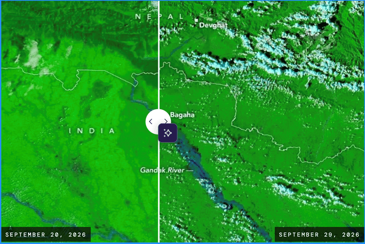
Gandak Breaches FRL in Nepal: Nasa Observatory Storms drenched Nepal’s mountainous Lumbini and Gandaki provinces with waves of torrential rain between Sept 24 and 27. The deluge, arriving late in the monsoon season, triggered landslides and pushed the Gandak River, also called the Narayani, to record levels in both Nepal and India. With runoff streaming into the braided river system, water overtopped and breached embankments in several areas, inundating farmland and settlements along the river for hundreds of kilometers. As authorities assessed the full extent of the damage, flooding and landslides had affected hundreds of villages and displaced thousands of people.
Images captured by MODIS (Moderate Resolution Imaging Spectroradiometer) on NASA’s Terra and Aqua satellites on September 20, 2026 (left), and September 29, 2026 (right), show the extent of the flooding. Data from Nepal’s Department of Hydrology and Meteorology indicated that a gauge in Devghāṭ reached as high as 11.94 meters on September 27, the highest since measurements began there in the 1960s.
Gandak breaches embankments at six locations The flood situation in north Bihar worsened on Oct. 01 as the swollen Gandak breached embankments at two more points in Saran and Muzaffarpur, taking the total breaches in Champaran and Saran to eight in four days. More than 200 villages have been inundated and standing paddy and other kharif crops damaged, prompting the state govt to step up rescue and relief operations.
The six Gandak basin districts of West Champaran, East Champaran, Gopalganj, Muzaffarpur, Saran and Vaishali remained under close watch.Two Indian Air Force (IAF) choppers made two sorties from near the state hangar at Patna airport to airdrop dry ration packets among flood-affected people in Panapur block of Saran, where the breach in the Saran embankment flooded villages and cropland in three panchayats.
The Gandak was flowing above its highest flood level (HFL) in Gopalganj, Saran and Vaishali. In Saran, floodwaters breached the right Saran embankment in Panapur block, inundating Satjoda, Karchhulia and Bhagwanpur panchayats and damaging paddy crops. Houses in a village were also swallowed by floodwaters.
Another breach occurred in the ring bund protecting the Tirhut main embankment in Sahebganj block of Muzaffarpur. Floodwaters also overtopped the 74-km Muzaffarpur-Chapra NH-722 at several points. In Vaishali, pressure from the Gandak threatened the ring bund near Pirapur village in Lalganj block on Wednesday evening. Vaishali DM Varsha Singh camped there overnight, while engineers and officials plugged the seepage by 4am Oct. 01.
The rising Ganga has compounded the situation, with backflow into the Gandak slowing its fall. WRD said the Ganga was rising from Digha to Kahalgaon, flowing 1.07 metres above danger level at Gandhi Ghat and 80cm above it at Hathidah, around 125km from Patna.
Union Minister Gadkari’s solutions for Bihar Floods: Dredging, water grid, protective walls Union Minister Nitin Gadkari has suggested that water grid, dredging and protective walls, along with planning can help Bihar get rid of floods.
175-yr-old Shiva temple in Malda collapses into Ganga A 175-year-old Shiva temple in Ratua collapsed into Ganga on Sept. 06 as flood conditions and riverbank erosion worsened across the district. The temple at Muniramtola in Ratua had faced the threat of erosion since last year, but temporary protective work had kept it standing. Alok Mandal, a local schoolteacher in his 50s, recalled: “In our childhood, the river was nearly 15km away from the temple. It was immensely popular among devotees, and a weekly market centred on it drew thousands, even from neighbouring Bihar.” As water levels surged, a large portion of the riverbank eroded on Saturday before the river swallowed the entire structure on Sunday evening.
The situation in Bhutni deteriorated after an embankment breached on the night of Sept 2, inundating the island. Constructed in 2025 at a cost of Rs 6.5 crore, the dyke’s failure prompted criticism from local MLA Gour Mandal, who alleged poor construction quality and blamed the previous TMC administration for the infrastructure failure. At least 62 villages across three panchayats in Bhutni are submerged, alongside the local police station.
Assam’s 2026 floods demand shift in India’s disaster management The Brahmaputra cannot be conquered by concrete; it must be understood, respected, and accommodated. The 2026 floods have washed away homes and livelihoods, but let us hope they also wash away our outdated illusions of river control. It is time to build a future where we do not just survive the floods, but live harmoniously with the river. (Dr. A.V. Yadappanavar)
HFL BREACH
Rivers in Extreme Floods During SW Monsoon 2026 This is the final analysis of CWC’s flood monitoring sites where we could track rivers crossing their respective Highest Flood Levels (HFL) in months of July (at 15 sites), Aug. (at 10 sites) and Sept. (at 25 sites) during South West Monsoon Season 2026. In addition, there are 2 sites where HFL breach has happened on Oct. 01, 2026 and 1 site where HFL breach is missed by narrow margin on Oct. 02, 2026.
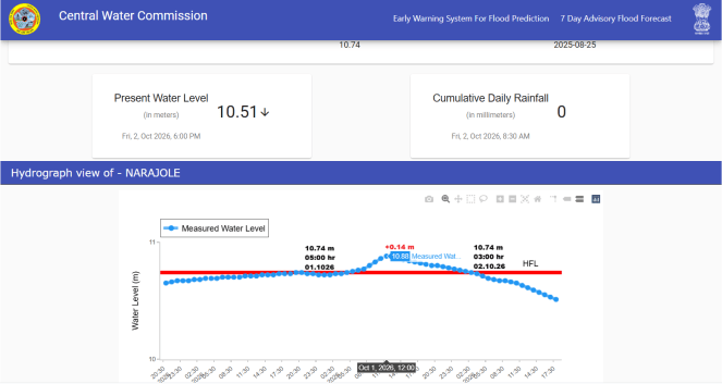
Rivers Crossing Highest Flood Levels in Sept 2026 In the last month of south west monsoon season 2026, we have been able to track Central Water Commission’s (CWC) 25 flood monitoring sites where rivers have crossed their respective Highest Flood Levels (HFL). These sites are spread over 5 river basins in 5 states. River basin wise the maximum 13 HFL crossings have occurred in Ganga basin followed by 6 in Godavari, 3 in Brahmani & Baitarni basin, 2 in East Flowing Rivers (EFR) between Mahanadi & Pennar basin and 1 in Narmada basin. State-wise the maximum 11 HFL breaches have taken place in Bihar followed by 6 in Odisha, 4 in Chhattisgarh, 2 in Uttar Pradesh and 1 each in Madhya Pradesh and Andhra Pradesh.
URBAN FLOOD
Lucknow sees flood after 18 years The flood situation in Lucknow has worsened. Around 40,000 homes have been inundated with up to 5 feet of water for the past six days. After 18 years, severe flood-like conditions have returned along the Gomti river in September-October 2026, similar to those witnessed in 2008.
Water levels in the Gomti River have been rising rapidly for the sixth consecutive day. The Faizullaganj area is the worst affected. Water, four to five feet deep, has accumulated in 40,000 homes. Three lakh people have been affected. More than 2,000 people are leaving their homes every day for other neighbourhoods or relatives’ houses.
Rise in flood levels in Sai river submerged several roads and entered homes in Godwa village, forcing some residents to evacuate. Water has also surrounded the Benti health centre and community toilet. Villagers fear the situation could worsen if the river continues to rise.
ENVIRONMENT GOVERNANCE
SOUTH ASIA
Nepal: Damage to Power Sector due to Rasuwa Floods Rs 74 Billion Floods triggered by the Bhote Koshi River on August 26 have caused an estimated Rs 74 billion in preliminary damage to Nepal’s power generation, transmission and distribution infrastructure, according to the Nepal Electricity Authority (NEA). The floods cut 430 MW of electricity from the national system and damaged the 220 kV hub of the Upper Trishuli-III ‘B’ project, along with infrastructure at several other hydropower projects. The authority said it has yet to determine the full extent of the damage because blocked access routes have prevented technical teams from conducting on-site inspections at several damaged locations.
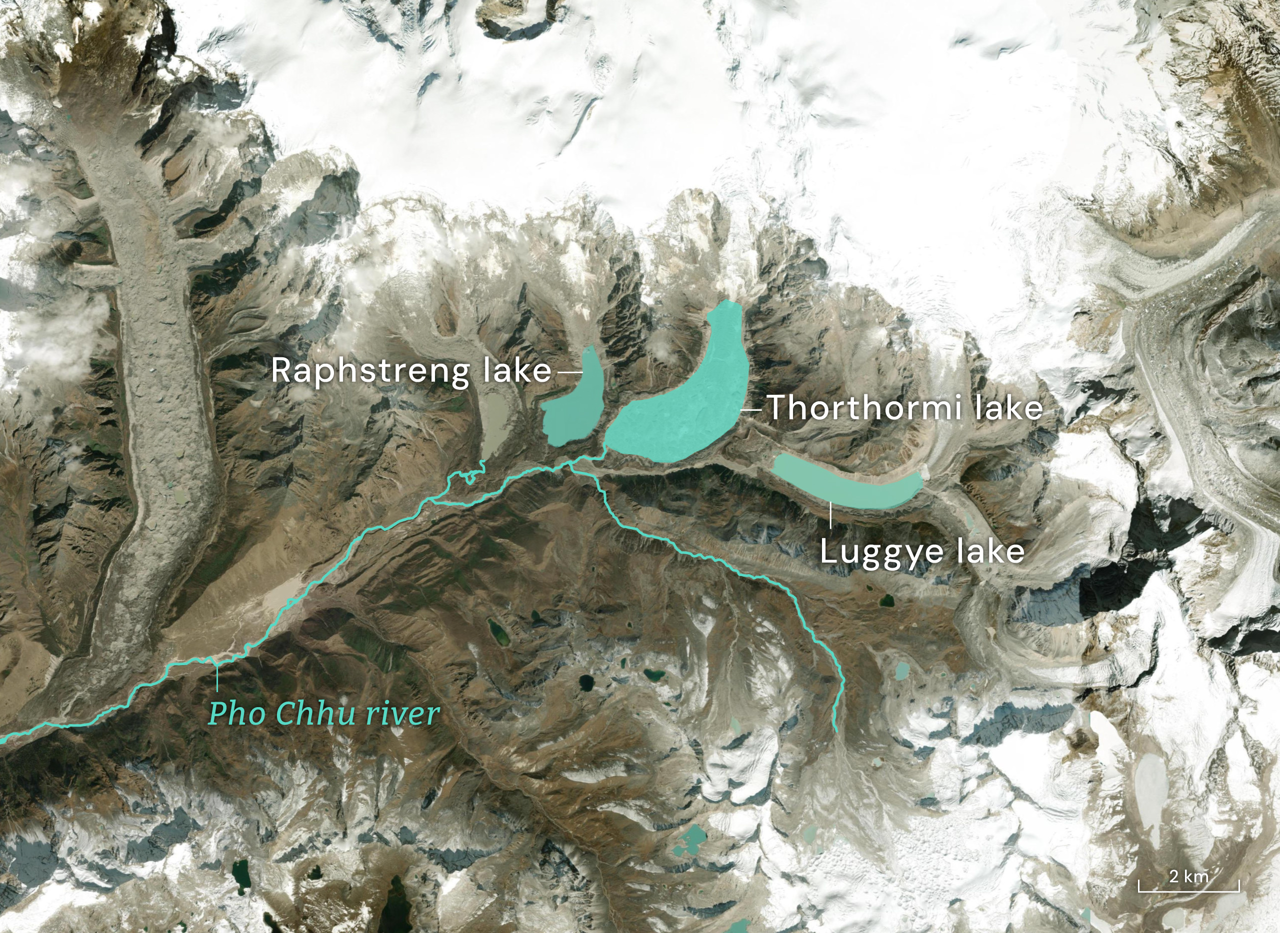
The Growing Himalayan Risks of Bhutan’s Hydropower ties with India Glaciologist Karma Toeb is at the Thorthormi glacial lake in Lunana, in north-west Bhutan that’s among the country’s most remote. Toeb is leading a team of experts testing technology that determines if the lake can be drained to reduce the risk of a glacial lake outburst flood (GLOF). A GLOF from the lake complex, which includes Thorthormi and Raphstreng lake right below it, could threaten two major hydropower projects. Punatsangchhu-II is a 1 GW project that began operating in Dec 2024, while the 1.2 GW Punatsangchhu-I is under construction.
The recent floods in Nepal highlight the need “to consider a broader range of cascading and compound hazards [in the Himalayan mountains]” rather than conventional rainfall and flooding risks alone, says Michael Williamson, chief of the Sustainable Energy Development and Utilization Section at the UN Economic and Social Commission for Asia and the Pacific. This includes ice and rock avalanches, landslides and GLOFs. For new hydropower projects, “more systematic screening for cascading and compound hazards” could be conducted before major investments are committed, he notes. Almost 99% of Bhutan’s territory is mountainous, and its glaciers are becoming increasingly unstable as temperatures rise.
Its 2026 glacial lake inventory recorded an increase from 567 to 620 lakes over the last five years. The Pho Chhu sub-basin, which covers part of Bhutan’s north-west and is home to Thorthormi and Raphstreng, saw the largest increase, from 157 to 187. A 2024 study of the basin estimated that a GLOF from Thorthormi and Raphstreng lake could put both Punatsangchhu-I and II at serious risk. It is not enough for the dams to have enough spillway capacity. They may still face serious problems if a flood carries heavy debris, sediment, boulders and trees, as these can choke tunnels, gates and intakes.
People have been making evacuation plans. In Punakha Dzong (likely to have max 6 hrs of lead time in case of GLOF), early last month, authorities conducted a GLOF evacuation drill, with activities including strengthening risk awareness, identifying escape routes and establishing and orienting evacuation teams.
Bhutan’s aging warning systems in focus as Bhutan prepares for bigger disasters More than 70 percent of Bhutan’s settlements are located along major river basins, where roads, bridges, hydropower plants, schools, hospitals, farmland and other critical infrastructure are also concentrated. As climate change alters rainfall, glacier dynamics and flood patterns, the govt has acknowledged that some early-warning systems are ageing, communication remains weak near dangerous glacial lakes, and preparedness must extend beyond disasters the country has experienced in the past.
Prime Minister Tshering Tobgay said Bhutan must prepare for unprecedented and compound disasters, strengthen warning systems, improve community response and reconsider where settlements and critical infrastructure are located. The Prime Minister said the Early Warning System at Thorthormi provides up to six hours of critical evacuation time—six hours for Punakha Dzong, 5.3 hours for Samdingkha and two hours for Lhadi—to save lives, protect property and preserve cultural heritage. Across the Punatsangchhu basin, 77 communities, 1,196 households and 11,921 people remain vulnerable. Similar EWS systems have also been established in the Mangdechhu and Chamkharchhu basins, strengthening disaster preparedness and resilience.
SANDRP
Also see: DRP 28 Sept. 2026 & DRP 21 Sept. 2026
Follow us on: www.facebook.com/sandrp.in; https://twitter.com/Indian_Rivers


