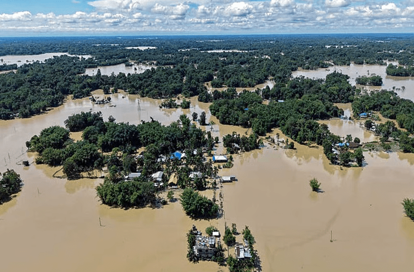
(Feature Image: Drone image showing flood situation in Assam. Source: TNIE/ Credit ANI, July 26, 2026)
Among many analyses of the recent Assam Floods, three contrasting ones stand out to illustrate the limitation of supremely confident perspective that engineering alone will solve the problem. One of them is by Mitul Baruah and another one is on edit page of The Times of India on Aug 17 2026. The third one by Arupjyoti Saikia is published in Indian Express. The one in TOI does not look at cultural or historical aspects of floods in Assam, nor the uniqueness of unprecedented upper Assam floods & the reasons behind it. The analysis by Mitul Baruah, in contrast, takes into account all this and in fact comes from lived experience in Majuli. Arupjyoti Saikia, an environmental historian, takes historical perspective.
The TOI article does not mention the culpability of both states (Assam and Nagaland, the upstream state) not only allowing the plunder but also failing to anticipate the consequences and even being shoddy in relief and rehabilitation.
The TOI article does end rightly when it says: “Brahmaputra will continue to rise. The question is whether Assam’s infra will continue to fall with it. The answer should be no.” But that answer is a bit hollow without recognizing the key aspects listed above. And most importantly, without building accountability into governance of Assam rivers and floods.
Both analyses, however, fail to mention the need to monitor the health of river catchments and the consequences of deteriorating health of the river catchments. Arupjyoti Saikia, however, does mention the impact of various interventions in the catchments. Ultimately, even in Upper Assam floods this year, the major contributing factor was the deterioration of health of the catchment due to indiscriminate mining in upstream catchments in Assam and Nagaland.
Upper Assam Floods direct result of Mountain and river floodplain grabbing Since July 19, an artificial flood has wreaked havoc in four Upper Assam districts. So catastrophic has this flood been that nearly 800 villages and an area of around 1,19,000 hectares of cropland have been submerged, sheets of mud have been deposited in fields and inside people’s homes and large areas in the countryside have been turned into lakes. More than 100 people have died and roughly seven lakh have been affected. Countless cattle have died.
The worst part of this disaster is that these are places not on the map of Assam’s annual flooding. But now, they seem to be doomed, as if a malignant wound has been created that will only spread and not heal.
Assamese society has been traditionally a flood-dependent society, not a flood-fearing or flood-resisting one. The relationship between the Majuli ecologies and monsoonal flooding is that of co-evolution. Both change and adapt. It is rhythmic. Of course, there were damages and inconveniences, but floods were rarely catastrophic. Residents accepted those inconveniences as trade-offs for the bounty of the fertile floodplains of the Brahmaputra.
On the other hand, riverside areas – areas outside of embankments – are now flooded for months, as the water cannot flow into the island’s interior, so much so that in a delusional turn of events, many communities in these areas have started demanding embankments. An ecological disharmony has been created, with the future quite uncertain for these fragile landscapes.
The Majuli story exemplifies processes occurring in the Brahmaputra Valley as a whole. There is no denying of the ecological volatility of the valley, shaped by, among others, a highly potent monsoonal regime with a massive network of Himalayan rivers, the huge volume of sediment load deposited by the Brahmaputra every year, resulting in the formation of transitory islands that interfere with the course of the river. In addition, an earthquake in 1950 with a magnitude of 8.7 on the Richter scale imbalanced the ecological foundation of the region.
All this does not adequately capture the current catastrophe in Upper Assam, which is a case of river and mountain grabbing – organised loot that has shaken the very core of the fragile ecologies of the region. The major southern-bank tributaries of the Brahmaputra – Dikhow, Dhansiri, and Jhanji, all originating in hills of Nagaland, and Disang, with its source in Nagaland and Arunachal – have become key sources of the extractive industry. Illegal mining of sand and stone has ravaged their riverbeds. Rampant coal mining and deforestation in the hills of next-door Nagaland have added to the fragility of these geographies. The mountains are thus denuded on the top and emptied out at the bottom.
This is a textbook case commodification of nature, which is here is total and rapid, driven by private profit, enabled by the state. The list of actors in this cruel theatre of loot may never be revealed, but there is a nefarious network at play here – a network of state and non-state elites, from the uplands and the plains alike.
The state’s culpability in the Upper Assam cataclysm, is glaring. It has either looked away for far too long or failed to prevent the devastating plunder of the rivers and the mountains. And as far as flood-relief and rehabilitation measures go, the state’s role has not been reassuring either. (By Mitul Baruah)
Assam Floods: Engineering a solution Contrast above analysis with the one on The Times of India Edit page which does not mention the uniqueness of Upper Assam Floods and the reasons of mining in Assam as well in upstream Nagaland, culpability of both states not only allowing the plunder but also failing to anticipate the consequences and even being shoddy in relief and rehabilitation. Nor does this article mention the cultural aspects of how people perceive floods and how it has evolved over the years. Even with respect to embankments, the article is supremely confident of achieving engineering solution when over 75 years of history speaks to the contrary.
Assam floods are not only story of river’s vagaries The catastrophic flooding in Upper Assam is not just a seasonal misfortune but the outcome of vulnerabilities that have quietly built up over nearly two centuries in a monsoon landscape. Unfortunately, Assam’s wilderness has often been treated as a puzzle for engineers to solve, with each crisis tackled in isolation, rarely considering the deeper ecological story that binds the landscapes together. Assam’s environment is inching closer to its tipping point, but it is not yet beyond repair. We need to understand and retain the intricate connections between highland and lowland, water and land, forests and floodplains, and accept that the resilience lost over generations cannot be rebuilt by technology alone. (By Arupjyoti Saikia)
Human factors magnified Assam flood impact: WWA Study The floods in upper Assam, which have claimed over 100 lives so far, displaced thousands and inundated 45,000 hectares of cropland, were worsened by rapid urbanisation, deforestation and local vulnerability, according to a new attribution study by the World Weather Attribution (WWA). Scientists from India, Sweden, the Netherlands, the United Kingdom and the United States analysed historical weather records and climate models and found that the rainfall totals were not exceptional, and are expected at least every two years. The study calls for wetland restoration, floodplain protection, localised early warnings & less reliance on rigid embankments.
A flood of woes in Assam Most people across Assam’s flood-prone districts know what to expect during six rainy months in a year, but the residents of Sivasagar and Charaideo, two historically safer districts along the Assam-Nagaland border, were not prepared for what hit them following a spell of heavy rainfall from July 18 to 22. The scale of devastation that occurred at an unprecedented speed has increased the challenge of recovering from the shock, with 99 dead and 7.21 lakh people affected, reports Rahul Karmakar.
Road engineering under scrutiny as Assam Battles prolonged urban flooding A study conducted by an engineering firm into waterlogging at Jorabat & Ninth Mile in Guwahati has identified major shortcomings in the road profile and cross-drainage arrangements.
HYDRO POWER PROJECTS
Aug. 2026: Eight Killed in THDC’s Vishnugad-Pipalkoti HEP Tunnel Disaster The disaster raises serious questions over geological risk assessment, tunnel safety, emergency preparedness and worker safety. The project’s prolonged delays, major cost escalation and history of accidents and environmental violations add to these concerns. Therefore, what is required is an independent assessment involving people with independent track record, to fix accountability learn lessons and try to avoid more disasters.
The incident is the ninth accident or weather-linked disaster to hit a hydropower or dam project in the Himalayan belt since June 24, spanning the Teesta, Brahmaputra, Chenab, Ravi, Beas, Sutlej and Yamuna basins. Others in the sequence include a flash flood that killed at least five near the North Eastern Electric Power Corporation’s Panyor Lower project colony in Arunachal Pradesh’s Keyi Panyor district in late June, a rockfall that narrowly missed workers at NHPC’s 231 MW Chamera-III in Himachal Pradesh’s Chamba district on July 24, damage to the Chanju-III project in the Ravi basin, and a flash flood at the Song dam site in Dehradun on July 28.
“The repeated Himalayan disasters involving hydropower projects indicate fragility of the Himalayas, and lack of proper appraisal, monitoring and compliance related to the projects. There are never any consequences for any persons or agencies involved. Most importantly, there is no independent post-disaster assessment to fix accountability and learn lessons for future,” said Himanshu Thakkar, coordinator of the South Asia Network on Dams, Rivers and People (SANDRP).
Seepage in NTPC Tapovan- Vishnugad HEP Tunnel A cavity developed in the main tunnel of NTPC’s Tapovan-Vishnugad Hydroelectric Project at Pipalkoti, Chamoli, on the morning of August 15, causing water seepage. As a safety measure, all workers in the affected section were immediately evacuated. A team of experts has reached the site and begun a technical assessment of the cavity. Modern machinery is being used to fill the cavity and secure the tunnel. According to NTPC management, tunnelling work in the affected section will remain suspended until the treatment is completed and the area is declared safe.
NGT takes suo motu cognisance of Sikkim tunnel tragedy The NGT on Aug 3, 2026, took up the matter of toxic gas killing 25 workers inside an under-construction tunnel of the National Hydroelectric Power Corporation (NHPC) in Sikkim’s Namchi district, Sikkim. The principal bench of the NGT directed that the matter be transferred to the eastern zonal bench and it will next be taken up on September 3, 2026.
NHPC knew about the risks at Teesta V Tunnel, documents show Just ten days before the tragedy, the company issued a tender for services that included management of methane gas in the tunnel.
DAMS
Mamallan reservoir: 30 percent work done but NOC pending The Water Resources Department (WRD) has commenced construction of the Mamallan drinking water reservoir without obtaining a No Objection Certificate (NOC) from the Fisheries Department, with the WRD seeking the mandatory clearance only after nearly 30 per cent of the project work has been completed. In a letter dated July 21, 2026, the Executive Engineer of WRD’s Araniyar Basin Division, Chepauk, sought an NOC from the Additional Director of Fisheries and Fishermen Welfare for the “Formation of a New Drinking Water Reservoir in Kovalam Sub-Basin” between the East Coast Road (ECR) and Old Mahabalipuram Road (OMR) in Chengalpattu district. Environmentalists and social activists have raised concerns about the delayed move to seek NOC and questioned how construction was allowed without obtaining the clearance, as the project potentially impacts fishing resources and local livelihoods.
Gujarat building two air-filled rubber dams Gujarat is constructing its first two air-filled rubber dams using South Korean technology to improve water storage, irrigation and flood management, the State government said on July 6, 2026. The two projects are being built across the Heran River at Rajvasana village in Chhota Udepur district and the Ambika River at Pathakwadi village in Tapi district at a combined cost of more than ₹162 crore.
INTERLINKING OF RIVERS
The Surplus That Never Was: Ken-Betwa’s Costly Bet The trouble is that almost no one outside government has been allowed to check the arithmetic. Himanshu Thakkar, coordinator of the South Asia Network on Dams, Rivers and People, has argued for two decades that the hydrological study underpinning the project is treated as a state secret, justified on the grounds that the Ken eventually feeds the Ganga and crosses an international border. The Central Empowered Committee, appointed by the Supreme Court, reached a similar conclusion in an official report, finding that declaring the Ken surplus before meeting the needs of its own upper catchment, a largely tribal region, was premature.
The project’s wildlife clearance remains contested before the Supreme Court, and its environmental clearance is still being challenged at the National Green Tribunal. Bhopal Singh, director general of the National Water Development Agency, has defended the project, saying its hydrological studies were carried out by the National Institute of Hydrology and reviewed by the Central Water Commission. But the underlying data still has not been released for independent scrutiny, which leaves the argument stuck almost exactly where it was a decade ago.
As Adivasis fight displacement and the destruction of a tiger reserve, questions surround how an Andhra-based company with limited dam-building experience won the Rs 3,389-crore Daudhan Dam contract in India’s Rs 44,605-crore Ken-Betwa project. The Nagarjuna Construction Company Limited donated Rs 60 crore to the BJP through electoral bonds in years when it faced tax raids. More government contracts followed in BJP states.
INTERSTATE WATER DISPUTES
SC to hear Tamil Nadu plea seeking Cauvery water from Karnataka The Supreme Court is scheduled to hear on Aug. 17 Tamil Nadu’s plea seeking urgent directions to Karnataka to release its share of Cauvery water. As per the cause list for August 17, a bench of Justices Vikram Nath and Sandeep Mehta will hear the matter. The apex court had on August 12 listed the petitions filed by the Tamil Nadu government and others, including the DMK, for hearing on August 17. Tamil Nadu has sought the immediate release of water, stating that crops in the Cauvery delta depend on timely supplies from Karnataka. The state has cited distress and delay in the release as grounds for urgent intervention.
To understand the clash between the two states, it’s important that we revisit the history about Cauvery River. The water body originates in Karnataka’s Kodagu district. Before reaching the Bay of Bengal, the river flows through Tamil Nadu, Puducherry and Kerala making these states a part of the Cauvery basin.
The Cauvery Water Management Authority (CWMA) chairperson Saumitra Kumar Haldar has called for better agricultural and water management practices and the formation of a river board that will “own, operate, manage, and regulate” reservoirs in the entire Cauvery basin to resolve the vexatious dispute between Tamil Nadu and Karnataka over the sharing of the river water.
URBAN RIVERS
Corruption in flood-lines regulation in Pune In this Photo Blog, Tara Tanmayi narrates some recent history in flood-lines regulation in Pune that shows how the disasters – including in ongoing 2026 monsoon- are the result of corrupt, non-transparent, unaccountable governance.
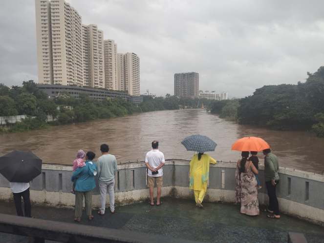
Vaigai river front plan raises concerns The state government’s announcement of Rs 53 crore for riverfront development along the Vaigai, Cauvery, and Thamirabarani rivers in the state budget on Aug. 05 has triggered confusion among stakeholders in Madurai, as the Rs 79 crore Vaigai riverfront project announced in the interim budget announced in February is yet to take off and remains in the tender bid stage.
Questioning the need for this before the earlier project is implemented, stakeholders urged the authorities to come up with a clear and comprehensive plan. Madurai Corporation has already floated tenders for the Vaigai riverfront development project. Official sources said the state had approved a `76-crore beautification project in February.
The WRD has submitted a Detailed Project Proposal (DPR) to the state government for rejuvenating the Vaigai from Theni to Ramanathapuram at an estimated cost of Rs 917 crore, earlier this month. Senior WRD officials said the proposal envisages the removal of invasive vegetation, strengthening of riverbanks and measures to prevent sewage from entering the river.
Meanwhile, the Madurai City Corporation Commissioner Gaurav Kumar stated that the corporation has started works for the Vaigai Riverfront Development Project at an estimated cost of Rs 79.26 cr. Commissioner said the project seeks to rejuvenate nearly 10 km of the riverfront along both the northern and southern banks within the city limits.
Global consultants to chart new course for Cooum, Adyar In yet another attempt to revive Chennai’s polluted waterways, the Tamil Nadu government on Aug. 05 announced that it will invite global tenders to prepare a Detailed Feasibility Report (DFR) and Detailed Project Report (DPR) for the restoration of the Cooum and Adyar rivers. According to the official, the global request for proposal will focus more riverfront development and on improving water quality by removing sewage outfalls through trunk sewer lines while simultaneously developing recreational spaces, walkways, cycling tracks and flood mitigation infrastructure along the riverbanks.
Faulty pipelines dump over 15 crore litres of sewage into Chennai rivers daily Govt data reveal a staggering 15 to 18 crore litres of untreated sewage from the city is seeping into stormwater drains, reaching Cooum, Adyar or Buckingham Canal in the end. As per data from the Municipal Administration and Water Supply (MAWS) department, the city has an installed capacity to treat close to 1,000 million litres of sewage per day against the total sewage of 835 MLD (million litres per day) or 83.5 crore litres pumped into the STPs.
As per the MAWS report submitted with the NGT, all of the city’s sewage is being treated before being let into the rivers and canals. But, of the nearly 835 MLD pumped into sewage treatment plants from pumping stations, only around 650 to 680 MLD reaches the STPs. The remaining 150 to 180 MLD of sewage seeps into stormwater drains to reach the rivers, show Metro Water data. Chennai generates around 950 MLD of sewage, which is less than the pumped sewage.
The state government has allocated Rs 29,863 crore to the Municipal Administration and Water Supply department in the revised budget estimates for 2026-27, Finance Minister N Marie Wilson announced on Aug. 05. The allocation is Rs 1,636 crore higher than the interim budget presented by the previous government for 2026-27. In 2025-26, the department received an allocation of Rs 26,678 crore.
The Minister further announced that the government would invite global tenders and prepare a detailed feasibility report and detailed project report to transform the Cooum and Adyar rivers into the identity of Chennai. The vision, he said, is to restore the rivers to a state where residents can enjoy boating, children can safely play in the water, and people of all ages can walk or exercise along clean and unpolluted riverbanks.
Noida Plans ₹29,315 Cr Hindon RFD based on Gomti RFD The Noida Authority has revived plans to develop a 25-km Hindon Riverfront on the lines of the Gomti Riverfront in Lucknow at an estimated cost of ₹29,315 crore. The project aims to transform the Hindon riverbanks with a six-lane road, green spaces, walking tracks, seating areas, children’s recreation facilities, and tourism infrastructure, with completion targeted by 2031.
The project will be implemented in three phases, with nearly 50% of the work planned during the first phase. A major challenge is the rehabilitation of around 10,000 families living along the riverbanks, estimated to cost ₹4,000 crore. The proposal also includes ₹15,000 crore for land acquisition, while the six-lane riverfront road alone is expected to cost ₹2,425 crore.
An earlier attempt to implement the project in 2012–13 failed despite land acquisition. Officials say illegal colonies have since come up on parts of the proposed land, making recovery and rehabilitation more difficult. The proposal has now been sent to the Uttar Pradesh Government for final approval. The Noida Authority will execute the project after obtaining the required No Objection Certificate (NOC) from the Irrigation Department, with the state government taking the final decision on implementation.
We ignore mountains feedback Building as if Shimla is a flat town and Kullu a riverfront has led to landslides and water shortages in the former and a corridor of damage during the monsoon in the latter. The ecology-based way forward is to accept that geology and water get the first word; sacred social geographies like devta routes and commons are not treated as mere folklore; gravity, water and forest maps, and carrying capacity inform planning and building decisions. (Dr Sonali Gupta)
RIVERS
ASI plans to conduct study of Sangam-era structures found in Kollidam riverbed The Archaeological Survey of India (ASI) plans to undertake a comprehensive study, including exploration and excavation, of two brick structures found on the bed of the Kollidam River at Koohur village near Lalgudi in Tiruchy, once the water recedes.
An ASI Tiruchy Circle team, led by Superintendent P Aravazhi, inspected the site after villagers posted about the remains on social media. The structures, found at two locations around 500 metres south of Moongil Karuppar Temple, could date back to the Sangam era, officials said.
“Future work at this site has the potential to reveal a major water-management feature of early historic significance in the Cauvery-Kollidam system,” Aravazhi said. The remains comprise large rectangular and wedge-shaped bricks with a consistent ratio of about 44:22:6, along with stone structural members. Their alignment suggest they may have formed an ancient water-management structure, possibly a sluice, an inlet or outlet channel, or a canal-regulating structure.
3 Bidar factories to be shut amid water pollution charges The state government on Aug. 10 ordered the immediate closure of three industrial plants in Humnabad Industrial Area after residents alleged that untreated chemical waste was being discharged into local water bodies, including the Guruganga and Manjra rivers. State rural development minister Eshwar Khandre, who is in charge of Bidar district, ordered the deputy commissioner to issue closure orders against M/s 6H Industries, M/s Sathyadeepthi K. Industries and M/s Himalaya Industries.
He also sought a compliance report within 24 hours. The minister took note of complaints of foul-smelling effluents entering a stream at Maniknagar and subsequently the Guruganga and Manjra rivers. Residents also alleged that the contamination has caused illnesses among people and livestock. Protests, rallies and public meetings have been held under the “Save Guruganga” campaign.
WRD prepares project report to curb pollution in 3 rivers The Water Resources Department (WRD) is preparing a detailed project report (DPR) to clean Cauvery, Vaigai, and Tamirabarani rivers, following the allocation of Rs 25 crore in the revised Budget. The DPR will focus on identifying major sources of pollution and suggesting measures to prevent the discharge of untreated waste into the rivers. The department is also expected to recommend steps to improve the overall water quality and protect the river ecosystems.
According to the official, the government is planning to establish sewerage and effluent treatment plants to treat liquid waste generated in urban and rural areas along the rivers. It is also considering comprehensive solid waste management, riverfront development in urban areas and regular cleaning of waste floating on the river surface.
Centre redefines Ganga floodplain, drops ‘construction-free zone’ provision The changes were notified by the Jal Shakti Ministry on Aug. 7 and published in the Gazette on Aug. 10 through the River Ganga (Rejuvenation, Protection and Management) Authorities (Second Amendment) Order, 2026.
Under the amended framework, an “active floodplain” is now defined as an area of the Ganga or its tributaries that is inundated during a flood corresponding to a one-in-five-year return period.
The broader definition of “flood plain” now includes three categories. These are the active floodplain, a regulatory zone covering areas inundated between one-in-five-year and one-in-25-year floods and a warning zone covering areas inundated between one-in-25-year and one-in-100-year floods.
The amendment also retains within the floodplain areas on either side of the Ganga and its tributaries that are inundated during floods corresponding to their greatest flow or a flood with a frequency of once in 100 years.
The earlier 2016 order had defined the floodplain as areas on either side of the river and its tributaries that come under water during floods corresponding to their greatest flow or a flood with a frequency of once in 100 years. The latest notification also changes the language governing the maintenance of the river’s banks and floodplains.
Instead of referring to a “construction free zone”, it states that the banks of the Ganga and its tributaries and their floodplains shall be maintained to reduce pollution sources and pressures and preserve their natural groundwater recharge functions through necessary measures.
The 2016 order had prohibited the construction of permanent or temporary structures for residential, commercial, industrial or other purposes in the Ganga, its banks, its tributaries and the active floodplain, subject to specified exceptions and permissions. The 2026 amendment does not alter that construction provision.
However, with the active floodplain now specifically linked to a one-in-five-year flood, it establishes the regulatory and warning zones as additional categories within the broader floodplain. The notification does not separately specify whether construction will be permitted or prohibited in these newly defined regulatory and warning zones.
Modeling climate-induced changes in hydrometeorological components and analyzing future extreme weather events using SPI in the Kosi River Basin, Uttarakhand This study investigates the impacts of climate change on hydrometeorological components and extreme events in the Kosi River Basin, a climate-sensitive region of the Central Himalayas. The findings underscore the need for integrated water resource management strategies to address emerging hydro-climatic risks in Himalayan headwater basins.
The study also reveals that total water availability or water yield in the Kosi basin could decline by around 4–7% by the end of the century. At the same time, rising temperatures could increase evapotranspiration by about 13%. The biggest concern is groundwater. Scientists estimate that groundwater recharge could decline by more than 20%, while surface runoff could increase by around 20%.
These changes in the water cycle could make droughts more frequent and longer-lasting. They could also affect natural springs in the Himalayas, which are an important source of drinking and domestic water for thousands of families. Declining water availability could affect agriculture, irrigation, livestock and local livelihoods, while also putting additional pressure on the fragile Himalayan ecosystem.
Kosi river basin spans nearly 3,420sqkm across Kumaon region, supporting thousands of people through local agriculture and mountain springs. While overall rainfall in the region is projected to increase, researchers found it will not boost water supplies. Instead, soaring temperatures will cause water to evaporate much faster.
The researchers emphasize that proactive interventions such as watershed management, spring rejuvenation, soil and water conservation, groundwater recharge enhancement, and nature-based solutions can play a crucial role in strengthening the basin’s resilience to future climate impacts.
Panel to look into allegations of fly ash disposal by NTPC plant in Garhi river The NGT on Aug. 7, 2026, directed the constitution of a joint committee to investigate pollution caused by the NTPC Limited plant in Tandwa village of Jharkhand’s Chatra district, due to the discharge of untreated effluent into the Garhi and Damodar rivers.
The applicant stated that the NTPC management is discharging burnt coal ash (fly ash) into the Garhi, due to which the river has become completely polluted and its water is no longer fit for use. Thousands of villagers and animals depend upon the water of this river. Flowing further downstream, the Garhi merges into the Damodar. As evidence, the applicant enclosed photographs of the fly ash flowing into the Garhi, along with copies of published newspaper reports regarding the issue.
Saat Mod tree felling: Eco-activists still await dialogue promised by CM A month after CM Pushkar Singh Dhami announced that all stakeholders would be brought together for a dialogue on tree felling at Saat Mod in Doiwala, eco-activists in Dehradun are still waiting for the talks to begin. The CM’s assurance came amid opposition to the proposed road widening in the area, with environmentalists raising concerns over its impact on forests and wildlife and questioning the need for the project.
YM Aug 2026: Floodplains remain under threat While three recent studies have once again highlighted the severe degradation of the Yamuna and the critical role of its floodplain, the Delhi Development Authority (DDA) has reportedly proposed dividing the Yamuna’s Zone O into Zone O-1 and Zone O-2 to facilitate the regularisation of unauthorised colonies in the floodplain. Such a move would further weaken the already diluted Zone O provisions, legitimise encroachments in one of Delhi’s most ecologically sensitive areas and set a dangerous precedent for floodplain governance.
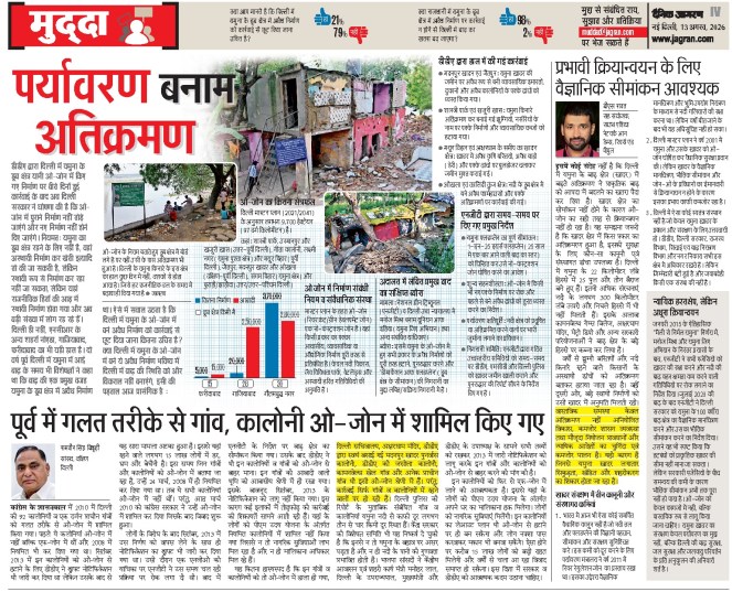
O-zone split with recreational activities to be allowed along floodplains The O Zone of Yamuna floodplain has now been divided into two parts under the Master Plan for Delhi-2047, with a lower degree of protection proposed for a “buffer area” farther from the river. While no construction or development will be permitted in O-1 – which falls within the defined 1-in-25-year floodplain – O-2, the area outside this zone, will allow specified recreational activities, including parks and green spaces, subject to regulations.
Bhim Singh Rawat of the SANDRP said the Delhi Development Authority (DDA), which was made the custodian of the Yamuna floodplain, was instead working towards weakening the laws meant to protect it. “On the one hand, DDA has been stalling scientific demarcation of floodplain in ongoing NGT cases for several years and now it is changing the very definition. The one-in-100-year flood should be the baseline, not 25-year flooding period. The last two flooding episodes have shown that even with smaller water discharges, the carrying capacity of the river in Delhi has been severely compromised,” he said.
The plan will now be sent to the MoHUA for final approval and subsequent notification. The decision was taken at a DDA meeting chaired by lieutenant governor Taranjit Singh Sandhu and attended by vice-chairman N Saravana Kumar and other members of the authority. DDA has not revealed details of the Master Plan yet and it is unclear how the O zone will be demarcated. O-Zone, a 9,934-hectare ecologically sensitive floodplain where permanent urban, residential and commercial constructions are largely restricted or prohibited, will be divided into two parts: Zone I, covering the riverbed and measuring 6,295 ha, and Zone II, comprising the outer sections of the floodplain. A 52-km cycle track and recreational spaces are planned in Zone II.
Govt plans two initiatives to enhance e-flows The two plans include to curb water loss by remodelling of part of Munak canal system and to reserve at least 30% of inflow water after the construction of three upcoming dams are under consideration. The proposals put forward by Haryana govt were presented in the Yamuna rejuvenation review meeting held by the union home secretary last week.
The 102-km Munak canal, constructed between 2003 and 2012, carries nearly 37% of Delhi’s raw water from Haryana daily, through the Carrier Lined Channel (CLC) and Delhi Sub-Branch (DSB), to the Haiderpur water treatment plant. To reduce water losses in the Munak canal system, the first plan proposes laying down 25km of fresh pipelines from the Khubru to Kakroi head of the canal system at an estimated cost of ₹750 crore.
This should be followed by the rehabilitation of 41.6km of the DSB. The canal currently sees more than 30% water transmission loss and, after the remodelling, could see losses go down below 5%, said officials. “Haryana has proposed that the entire cost of remodeling the system should be borne by Delhi and the Union government. Haryana will ensure that 330 cusecs of water reaches Haiderpur. The water saved in transmission loss should be diverted to the river as part of the e-flow,” said one of the officials.
Sludge may be behind ammonia spikes: CPCB Accumulated sludge in the Yamuna bed at Wazirabad may be contributing to ammonia spikes that have caused recent disruptions in Delhi’s water supply, preliminary findings of a Central Pollution Control Board (CPCB) study based on samples collected from the pondage area have shown, government officials said. The study was undertaken at the behest of the Upper Yamuna River Board (UYRB), which is examining the causes of recurring ammonia spikes and their impact on Delhi’s water supply.
The findings also come as the DJB prepares to dredge and revive the Wazirabad pondage area up to Ram Ghat. The project, approved last month, will involve removing around 387,000 cubic metres of silt, with work expected to begin after mid-Sept, once the monsoon ends.
But dredging the pondage area may not provide a lasting solution. A one-time de-sludging exercise could be followed by fresh accumulation as nitrogen-rich water continues to flow into the river through drains, a DJB official said. “The long-term situation will improve only when nitrogen levels in the water coming through drains are brought within acceptable limits. The CPCB will study the issue thoroughly and suggest solutions,” the official said.
Yamuna’s pollution level shoots up ninefold in Haryana An analysis of data collated by Haryana State Pollution Control Board between Jan 2021 and June 2026 – covering 14 monitoring points in Yamunanagar, Karnal, Panipat, Sonipat, Palwal and Faridabad – found several pollution hotspots along the river and its feeder drains. Of 57 samples with BOD readings in 2026, 38 breached the Central Pollution Control Board’s bathing-water limit of 3 mg/l. Faecal coliform exceeded the desirable 500 MPN/100 ml in 35 of 55 samples.
Illegal jeans factory sealed thrice, still operational in Gurgaon Trilok Dyeing in Rahaka was sealed three times, but was still found operational, a complaint has claimed. According to the complaint – filed by Delhi-based environmental activist Varun Gulati with HSPCB – environmental compensation of Rs 1.6 crore had been imposed on the unit by the board on one occasion. The matter has reached the vigilance wing of HSPCB, with its chief vigilance officer (CVO) seeking an action-taken report from the board’s member secretary.
FISH, FISHERIES, FISHERFOLKS
Mass fish death in Ennore Creek Aquatic heat wave conditions caused by hot water discharge from NTECL Vallur’s power plant may have been responsible for the Independence Day Fish Kill in Ennore Creek, fishers and activists say. Fisher accounts of the sequence of observations and tidal movement point to the Kuruvimedu and Railway Bridge Canals as the likely source of the cause of the fish kill. Fishers and Save Ennore Creek campaign have demanded a thorough investigation to fix responsibility for the Independence Day Fish Kill.
The Railway Bridge Canal receives discharge of hot water (spent coolant) from NTECL’s 3 x 500 MW Vallur thermal power plant, and has long been a target of complaints by local fishers. Their observation is strengthened by the findings of a water temperature study conducted on 9 August by Kattukuppam fishers S. Kumaresan and Raja Masilamani and Save Ennore Creek campaign volunteers. The study revealed aquatic heat wave-like conditions at four sampling locations 585 to 1045 metres from the plant’s discharge point. The highest recorded temperatures were 40.8°C and 40.6°C at locations in the Railway Bridge Canal.
The latest fish kill has also revived concerns among fishing communities about the long-term impact of industrial pollution on their livelihoods. Fishers recalled the 2023 CPCL oil spill, saying fish and prawn populations in the creek took more than a year to recover. They fear the latest incident could similarly affect fish stocks and fishing incomes for months.
The Save Ennore Creek group and Kattukuppam fishers have demanded compensation for the losses suffered by fishing communities and called for the implementation of the National Green Tribunal’s July 2022 order directing the ecological restoration of Ennore Creek with meaningful participation from fisher communities.
House panel criticises Centre’s flagship welfare support for fisherfolk A parliamentary panel has criticised the Union government’s flagship welfare support for traditional fisherfolk, noting that only about 2.1% or 595,000 of the country’s estimated 28 million fishers received financial assistance during the annual fishing ban between 2020 and 2025. The panel cited the current economic parameters and inflation and recommended an increase in the financial assistance during the fishing ban to at least ₹10,000 per fisher per year without any annual contribution from fishermen. It urged immediate measures to significantly expand the reach of the scheme.
The panel flagged the slow pace of investment in fisheries infrastructure. It noted that India has 1,547 notified fish landing centres, but only 379 have been selected for development as fishing harbours or fish landing centres since 1964. The panel said just 287 of them had been completed by June 2025. The panel said existing facilities can accommodate 148,000 fishing vessels, against 238,000 active vessels operating in the country. It called the gap significant, and the panel urged the fisheries department to select more landing centres for modernisation, consider relaxing some selection criteria, and speed up project implementation.
SAND MINING
Protect frontline forest staff: SC The Supreme Court held that the duties performed by frontline Forest Officers and Forest Guards within the National Chambal Gharial Sanctuary extend far beyond forest conservation and constitute highly dangerous tasks intrinsically connected with the maintenance of public order. The Court directed the States of Madhya Pradesh, Rajasthan, and Uttar Pradesh to immediately issue notifications under Section 218(3) of the Bharatiya Nagarik Suraksha Sanhita, 2023, recognizing that the duties of frontline forest staff safeguarding the National Chambal Gharial Sanctuary are intrinsically connected with maintaining public order. The Court warned that failure on the part of district administrations to enforce its comprehensive enforcement and monitoring directives would invite strict departmental action and legal proceedings for wilful non-compliance.
NGT petitioned against illegal riverbed mining near Kaziranga Seven years after the Supreme Court ordered a complete ban on mining and related activities along its southern boundary, Assam’s Kaziranga National Park and Tiger Reserve faces a threat from renewed riverbed excavation within its proposed Eco-Sensitive Zone (ESZ). Mohajon Kro, a resident of Diphu in Karbi Anglong district, petitioned the NGT and the MoEF&CC on August 5, alleging large-scale and mechanised sand mining in the Deihori River. He said that excavators, earthmovers, and dumpers are being used to extract sand from the river channel, causing ecological damage to the river and affecting the Scheduled Tribe population dependent on it.
According to the petitions, excavators and other heavy earthmoving machinery are being driven directly into the Deihori River to extract sand and sand gravel from the active channel. The petitioner alleges that such extraction is being carried out in a manner contrary to the principles laid down under India’s sustainable sand-mining framework, which seeks to prevent indiscriminate removal of riverbed material and protect river morphology and aquatic ecosystems.
As of August 10, emerging reports from various organisations highlighted extensive hill cutting, stone quarrying, and riverbed mining activities near Kaziranga. Observers further report daily transportation of hundreds of truckloads of extracted materials, ranging from gravel to stone, from the restricted areas.
Ensure no illegal mining takes place in Punjab’s Roopnagar: NGT On Aug 3, 2026, the NGT directed authorities to ensure no illegal mining takes place in Roopnagar district of Punjab. Punjab Pollution Control Board (PPCB) filed a report on April 14, 2026, disclosing the status of stone crushers in Roopnagar. The PPCB report revealed that only 10 out of 171 stone crushers in Roopnagar district were compliant. Counsel for the PPCB stated that action was initiated against four stone crushers, and environmental compensation has been imposed.
The PPCB chart reveals that 71 stone crushers were non-compliant and 55 were partially compliant. They are required to be inspected. The PPCB is required to take appropriate action for the violation, noted the tribunal. The chart also indicated that only 153 of 171 stone crushers were visited. Therefore, 18 still remain to be verified and inspected by the PPCB. Counsel for the PPCB sought time to file a comprehensive report on the matter. Counsel for the Applicant also submitted that they filed details of illegal mining currently in progress in Roopnagar district.
RAMSAR WETLANDS
How will SC order impact mining around Ramsar wetland sites? Explainer on what prompted the Supreme Court to dwell on this question? What does the law say about mining in Ramsar wetlands?
GROUNDWATER
Groundwater that glows yellow-green in U.P. Decades of industrial waste dumping have contaminated groundwater with chromium (VI) across parts of three Uttar Pradesh districts, exposing villagers to unsafe water and serious health risks. Despite years of complaints and court intervention, the government’s efforts to identify contaminated areas, provide safe drinking water and healthcare, and clean up toxic waste remain slow and inadequate.
URBAN LAKES, WETLANDS
Rethinking Urban Flooding & Groundwater Recharge in Bengaluru The Bengaluru, a primary metropolitan centre in India, is currently grappling with the dual crises of urban flooding and severe groundwater depletion. These challenges are driven by rapid urbanization, which has seen built-up areas increase from 42% to 86% over two decades, resulting in a dramatic loss of vegetation and wetlands. This study addresses a critical research gap by integrating 27 years of hydrological data (1997–2023) with a multi-perspective analysis of the city’s fragmented governance.
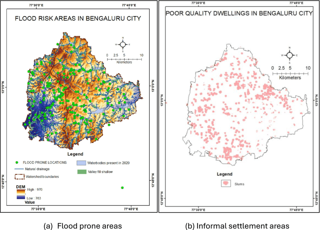
The findings indicate that although rainfall remains a vital resource, its effectiveness is neutralized by institutional fragmentation and weak enforcement of buffer zone regulations. We propose a phased implementation roadmap for water-sensitive urban design (WSUD), highlighting nature-based solutions like recharge wells and lake rejuvenation as essential for climate resilience and sustainable water management. This research provides a scalable model for transforming rapidly growing cities in the Global South into water-sensitive urban environments.
Bengaluru: 105% Rise in Concrete, 70% Lakes Hit by Encroachment A 27-year study has found that unplanned urbanisation, encroachment of lakes and poor coordination among government agencies have severely disrupted Bengaluru’s natural water cycle. Between 1997 and 2023, the city’s built-up area increased from 42% to 86%, representing a 105% rise in concrete cover. At the same time, around 70% of historical lakes were lost to encroachment or construction.
As a result, rainwater that once infiltrated the ground and helped recharge groundwater now runs off rapidly onto roads, increasing urban flooding while leaving aquifers depleted. The study also highlights the lack of coordination among government agencies as a major factor worsening the crisis. However, the restoration of Jakkur Lake shows that lake revival, rainwater harvesting, water-permeable infrastructure and community participation can help address both flooding and water scarcity. The researchers’ message is clear: the future of cities depends not on more concrete, but on development that works with nature.
A push to protect the pink, preserve the wild Maharashtra Forest Minister Ganesh Naik has directed authorities to take concrete measures to protect flamingo and wildlife habitats in Navi Mumbai, including DPS Lake in Nerul and Sector 52A. Naik said the Palm Beach Road area was not merely a flamingo habitat but also supported golden jackals, mongooses and other wildlife. At a meeting on conservation measures, officials also discussed a proposal to include Sector 52A in the Flamingo Conservation Zone.
The directions come after fencing was carried out across several plots in Sector 52A on July 18. While Plot No 3 is the only registered plot, fencing has reportedly been undertaken on several others. The fenced sites do not display mandatory boards detailing the work or permissions, and nobody was present to produce or explain the relevant permissions.
Activist Sunil Agarwal called for an investigation. “If Sector 52A is being considered for inclusion in the Flamingo Conservation Zone, authorities must establish who permitted fencing on multiple plots. Only Plot No. 3 is registered. The authorities must verify the legality of the exercise and ensure the wildlife habitat is not compromised,” he said.
Allegations of illegal sand mining will be probed Large-scale illegal sand mining in the dry lake bed at Malappambadi village near Tiruvannamalai, allegedly by senior DMK leader and former PWD and Highways Minister E.V. Velu, will be probed, Collector Vandana Garg has said. Vandana Garg’s reaction came after an NGO lodged a complaint with the DVAC, alleging that a large quantity of sand from the dry lake bed was illegally mined by Mr. Velu and his supporters for levelling an open land to organise the DMK’s northern zone youth wing conference on December 14 last year.
URBAN WATER
Protests in Visakhapatnam, Thane against mega data centres over water, public resources In Thane, the data centre facing protests is Amazon’s hyperscale facility, spread across about 53-58 acres at Balkum and Majiwada. The campaign began after residents learnt that data centres are classified as essential services, raising concerns that they could receive priority access to water and electricity during shortages. After scrutinising the project’s approvals, the group sent Amazon and the Thane Municipal Corporation (TMC) a 22-point questionnaire.
It asked whether mandatory public notices on environmental clearance had been issued, whether key water and sewerage approvals had been obtained before construction began, and how the project’s water demand compared with subsequent commitments made by the civic body. They also sought details on thermal impact, emergency preparedness, inspection reports, power demand and compliance with environmental conditions.
The TMC said residents need not worry about drinking water being diverted. Deputy city engineer Dhole said the proposed Amazon facility would receive 12 million litres a day (MLD) of treated sewage water. He said the corporation currently had sewage treatment capacity of about 300 MLD and supplied around 600 MLD of water across the city, with recycled wastewater being supplied for industrial use rather than as potable water.
However, residents are also concerned about heat generated by cooling systems, noise from equipment, pressure on the local power network and the cumulative impact of locating a massive data centre next to homes, schools and hospitals. Nearly 800 km away, a similar campaign is taking shape in Visakhapatnam, where several citizen groups are opposing a proposed Google-Adani hyperscale AI data centre complex. Planned as a 1-GW cluster split across three sites, the project would cover about 200 acres at Tarluvada, 120 acres across Adavivaram-Mudasarlova, and 160 acres at Rambilli in Anakapalli district.
NGT seeks fresh report on illegal vehicle washing centres in Noida, G Noida The green body is hearing a matter initiated suo motu based on a newspaper report which claimed that 1,000 illegal vehicle washing centres in Noida and Greater Noida were wasting around 30 crore litres of water every month. In a recent order, a bench of NGT noted that the state’s groundwater department had submitted a report that 193 washing centres had been identified in Gautam Buddha Nagar, of which 55 are in industrial areas and 138 in non-industrial areas. It noted that the report detailed that among the 55 industrial units, only 14 have the requisite permissions, while 12 have applications pending.
Twenty-three units, however, were found to be operating without any permission or application, on whom the district groundwater management council had decided to impose a penalty of ₹2 lakh under the UP Groundwater Act, the bench noted. Regarding the 138 units in non-industrial areas, the Tribunal said the Uttar Pradesh Pollution Control Board counsel informed it that the electricity supply to 100 units has already been disconnected. The Tribunal, however, sought a “complete report” in this regard from the UPPCB. It directed the groundwater department and UPPCB “to file their compliance reports within four weeks.” The matter has been listed for further proceedings on October 12.
NGT Directs DJB to Act Against Paharganj Hotels The NGT on July 17, 2026, expressed concern over the slow progress by the DJB in regulating groundwater extraction by hotels and guest houses in Delhi’s Paharganj area. The tribunal noted that only 162 out of 555 establishments had installed piezometers or digital water meters in the past three months, while 393 establishments continued extracting groundwater without measurement systems.
DJB informed the tribunal that notices had been issued to remaining establishments on July 7, 2026, directing them to install digital meters or piezometers within seven days, failing which legal action would be initiated. The tribunal had earlier, on April 1, 2026, ordered installation of monitoring devices to assess groundwater extraction and enable regulation and recovery of charges. DJB has been asked to submit a compliance report.
₹2,574 cr ‘Wazirabad Water Supply Improvement Project Delhi Water Minister Parvesh Sahib Singh on Aug 10 said that in-principle approval has been given by the Screening Committee of the Department of Economic Affairs (DEA) for the “long-awaited” ₹2,574 crore Asian Development Bank-assisted ‘Wazirabad Water Supply Improvement Project’. Under the project, old, damaged and undersized pipelines will be replaced, while new transmission and distribution lines will be laid wherever required. Existing networks will be interconnected to improve pressure, distribution and reliability
Water contamination row in Rajarhat complex A water contamination crisis has hit a housing complex near Rajarhat four-point crossing, with more than 100 residents reportedly falling ill. Several have had to be hospitalised, including a four-year-old child, residents alleged. About 30 per cent of the residents have left the complex to seek alternative accommodation, they said. Residents lodged an FIR at Rajarhat police station on Aug. 12 night. The trouble at Happyville began last Friday, when residents noticed a foul smell in the tap water.
WATER POLLUTION
E coli found in drinking water at rail stations: CAG Comptroller and Auditor General has flagged gaps in sanitation and minimum essential amenities at 458 out of 512 railway stations, including presence of E coli bacteria in water coolers at eight stations. The CAG report on “passenger amenities and sanitation at non-suburban railway stations”, presented in Parliament last week, said bacteriological analysis of drinking water was not carried out at 59 stations in six zones.
AGRICULTURE
Sunny side up, unevenly shared PM-KUSUM has turned solar power into a possible new income stream for farmers. But the scheme’s most ambitious component favours those who already have land, capital, and collateral. (Anusreeta Dutta)
DROUGHT 2026
Drought stress in 64 per cent of farmland in India The latest satellite imagery from the ICAR-Indian Agricultural Research Institute’s CREAMS Lab indicates that as of August 12, as much as 64% of the country’s agricultural area is experiencing drought stress due to insufficient rainfall. India has completed 92% of its normal kharif sowing in the ongoing monsoon season, which means the standing crops are at risk as the rainfall deficiency increases.
A significant portion of the country is experiencing mild drought, with regions also affected by moderate, severe, and extreme drought. The CREAMS Lab’s report highlights that the major food-producing states of Punjab, Karnataka, Madhya Pradesh, Andhra Pradesh, Haryana, and Tamil Nadu fall in the extreme drought category.
The area affected is currently 38% more than it was in the same period last year, reflecting increased agricultural stress. Despite some improvement in rainfall during the month of August, the country has recorded a total rainfall deficiency of 13% since June 1, with South and East India facing the highest levels of deficiency.
MONSOON 2026
IMD’s district wise daily and cumulative rainfall figures upto Aug. 17, 2026.
Karnataka faces 30% rain deficit as dry spell continues
FLOOD 2026
Ganga Floods Hit Villages in Farrukhabad Flooding in the Ganga River has severely affected several villages in the Barhpur development block of Farrukhabad, including Bilawalpur, Prahlad Ki Madhiya, Dauli Ki Madhiya and Thatha Ki Madhiya. Floodwater has entered homes, disrupting daily life. Many residents have been forced to live on rooftops under tarpaulins and plastic sheets.
Residents said the Ganga’s water level rises every year due to continued rainfall in the hill regions, causing flooding in the area. This year too, the situation remains serious. Around 1.5 feet of water has accumulated on roads connecting the villages, making travel difficult. Residents are using bullock carts and tractors to meet their daily needs.
40 houses in Malda’s Jittutola village slide into Ganga The Ganga washed away around 40 houses within a few hours at Jittutola village in Malda’s Ratua-I block on Aug. 16 forcing residents to flee as large portions of the riverbank collapsed. This devastation came a day after the BJP MLA of Manikchak, Gour Chandra Mandal, lashed out at irrigation department officials and contractors over the alleged substandard erosion-control work in the neighbouring Bhoothni. Jittutola residents said Sunday’s erosion affected a stretch 160 metres long and 100 metres wide. Fearing an impending collapse, several families had been removing their belongings over the past few days.
HFL BREACH 2026
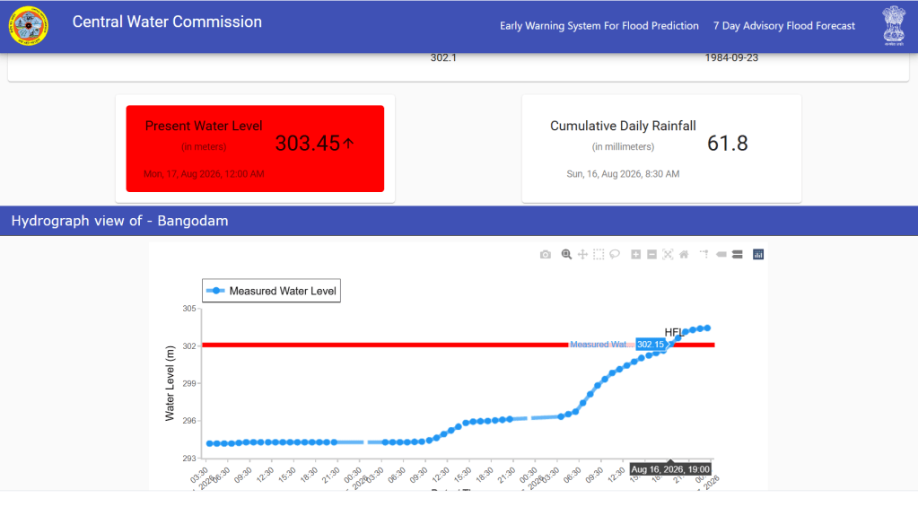
After 42 years, River Hasdeo at Bangodam site in Korba district, Chhattisgarh has crossed its HFL 302.1 meter dated 23.09.1984 at 19:00 hour on 16.09.2026. Present flood level is 303.45 meter at 01:00 hour on 17.08.2026 with rising trend.
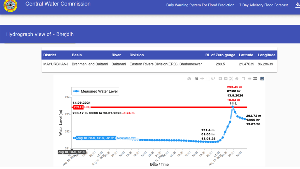
After missing HFL breach by 0.24 meter on 28.07.2026, river Baitarani at Bhejdih site in Mayurbhanj district, Odisha has crossed its old HFL 293.41 meter 14.09.2021 at 07:00 hour on 13.08.2026 just by 0.04 meter and has set 293.45 meter as new HFL at the site.
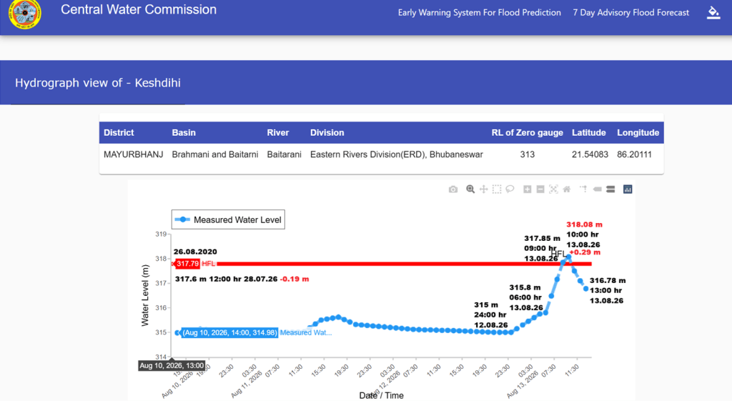
After missing the HFL breach by 0.19 m on 28.07.2026, the Baitarani river at Keshdihi site in Mayurbhanj district, Odisha, crossed its previous HFL of 317.79 m dated 26.08.2020 at 09:00 hr on 13.08.2026.
CLOUD BURSTS
Arunachal flash flood: Five Army Personnel Missing Arunachal Pradesh witnessed two major rain-related disasters on Aug. 14 evening, with a flash flood in Dibang Valley leaving five Army personnel missing and a separate landslide in Upper Subansiri claiming four lives. Search, rescue and recovery operations are continuing at both locations amid difficult weather and terrain conditions.
In Dibang Valley district, a cloudburst in the Pashu Pani area of Anini triggered a massive flash flood and landslide that swept away two shelters at the 5th Grenadier’s Pasu Pani Army camp on Aug. 14 evening. According to officials cited in the reports, seven Army personnel were swept away in the sudden flooding. Two were subsequently rescued, while five remain missing.
In a separate incident in Upper Subansiri district, a major landslide struck the Keojaring–Byaching road cutting/construction site, burying several workers beneath debris. Four people have been reported dead: Tadu Baki, Taji Rai, Markosh Basumatari and Babul Ali. The body of Babul Ali has been recovered, while search and recovery operations for the remaining victims are continuing. The incident occurred amid heavy rainfall in the district, with authorities working to clear debris and determine the full extent of the casualties.
Although the two incidents occurred at separate locations, both were linked to heavy rainfall and unstable terrain, highlighting the vulnerability of Arunachal Pradesh’s mountainous districts to sudden weather-related disasters. The incidents also underscore the importance of rapid communication and inter-agency coordination in Arunachal Pradesh, where mountainous terrain, road-cutting activity and intense rainfall can make access to disaster sites difficult.
As of the latest reports available on August 15, five Army personnel remain missing in Dibang Valley and four people have been reported dead in the Upper Subansiri landslide. Rescue and recovery operations are ongoing.
Chamoli Cloudburst: Bridge, Bulldozer & Vehicle Swept Away A cloudburst in Uttarakhand’s Chamoli district on Aug. 10 triggered flash floods, causing the Tamak Nullah in the Niti Valley to overflow and wash away the Border Roads Organisation (BRO) bridge over it. Teams from the police, administration, SDRF, and NDRF have been dispatched to the scene. A BRO employee was swept away and remains missing in the incident. The collapse of the bridge disrupted traffic beyond Malari.
The rain that fell Monday afternoon caused extensive damage to local homes and farmland. Disaster Management Officer Nand Kishore Joshi said rescue teams have been dispatched to the scene. Residents living near the drain have been asked to move to safer locations. The flash flood also swept away a dozer and a vehicle. The horrific visuals from the site have surfaced, showing the scale of devastation.
Study to Probe Cause of Tamak Nala Flooding The actual cause of the sudden rise in water flow and heavy debris at Tamak Nala on August 10 will now be determined through a scientific study. The Disaster Management Department has written to major scientific and technical institutions to investigate the incident. Experts will examine whether the surge was caused by normal rainfall, intense localised rainfall, a cloudburst, rapid surface runoff or another hydrological factor.
As per Aug. 16 report, a rescue and search operation is underway on a war footing under the direction of the district administration to locate a Border Roads Organisation (BRO) havildar who went missing after a cloudburst triggered a sudden surge of water and debris in the Tamak Nala near Long Segdi village in Joshimath tehsil, Chamoli. The missing personnel, driver Pankaj Rudhaula, was posted with 123 BRO Unit and was swept away by the strong current.
Mandi 2025 Floods: Human Encroachment Worsened Disaster A scientific study has found that the devastating June–July 2025 floods in Thunag, Mandi district, Himachal Pradesh, were not caused only by cloudbursts and heavy rainfall. Encroachment on natural river channels and floodplains, unplanned construction and the area’s mountainous terrain significantly increased the disaster’s impact.
Buildings located very close to the river were the worst affected, while several weaker houses located at greater distance and elevation survived. Before the flooding, Thunag had already received 85.2 mm of rain. Rainfall reached 119.4 mm on June 30 and 216.8 mm on July 1, causing floodwaters to spread rapidly within 30–60 minutes.
The study found that 205 buildings were affected and its model estimated flood damage with 95.34% accuracy. Houses, shops, roads, agricultural fields and cattle sheds suffered extensive damage. Direct economic losses in Thunag were estimated at ₹6.2–7.8 crore. The study’s key message is clear: cloudbursts cannot be prevented, but construction in natural river channels and flood-prone areas can be avoided.
₹886 Cr Damage in Himachal According to the latest report of the State Disaster Management Authority (SDMA), Between June 30 and August 9, natural disasters and accidents have claimed 157 lives, while the state has suffered estimated economic losses of around ₹886 crore. The SDMA report states that 68 people have died in landslides and flash floods during the monsoon so far, while 89 people have lost their lives in road accidents.
ENVIRONMENT GOVERNANCE
Is the Supreme Court distancing itself from its environment legacy? My former colleague in the Bombay High Court, Justice Gautam Patel, has analysed Supreme Court judgments dealing with the environment in an article titled ‘Consistently Inconsistent: Environmental Law and the Supreme Court’. Justice Patel finds that by and large, the Supreme Court has supported the environmental cause raised by non-governmental organisations. It has not shown the same degree of support to cases challenging infrastructure projects. Justice Patel says it is in precisely this area that an intervention of the Supreme Court is vital, and yet it is here that we find a reluctance to come down on the side of the environmentalists. He says the jurisprudential inconsistency is apparent when one sets these decisions against the principles that the Supreme Court itself repeatedly enunciates in the broadest possible terms. It is that consistent inconsistency that exacerbates the threats to the environment.
Is there any conflict between environment and development? The answer, according to me, is an emphatic no. Three decades ago, the Supreme Court had observed in the Vellore Citizens case that the traditional concept that development and ecology are opposed to each other is no longer acceptable. In my Vanashakti review judgment, I have said that it is unfortunate that a false narrative is being created pitting environment against development. Both are part of the constitutional construct of sustainable development.
When a conscientious citizen approaches the Court with a grievance that a particular project is in breach of environmental norms, what should be the approach of the court? Should the Court throw out the challenge at the threshold by asking aloud, almost posing a leading question to itself, whether any development project in India has gone unchallenged? It is true that there are many busybodies who file frivolous petitions. However, such attempts have been deprecated by the courts, but that cannot be the reason to paint all challengers with the same brush. There are committed environmentalists in our country who continue to espouse the cause of the environment. Where would they go if the doors of the courts are closed? According to me, that cannot be the approach of a constitutional court. Instead, the Court should ask: Has the project complied with the environmental norms? The Court should assure itself and citizens that all projects, big or small, infrastructure or otherwise, should comply with the environmental norms. (Supreme Court Judge Justice Ujjal Bhuyan)
Supreme court upholds centre’s power to notify post-facto clearance The Supreme Court has struck down the centre’s 2021 Office Memorandum (OM) that created a mechanism for granting post facto environmental clearances to projects that violated prior environmental clearance norms. At the same time, it stated that the central government has the power to frame statutory amnesty schemes for specified categories of such violations under the Environment (Protection) Act, 1986. On July 29, the Supreme Court decided three connected writ petitions questioning the centre’s two amnesty schemes introduced in 2017 and 2021 to regularise projects that had started construction or operations without obtaining prior environmental clearance. Experts say the ruling weakens the principle of prior environmental clearance.
CAG finds 98% shortfall in Green India Mission forest cover targets The Comptroller and Auditor General of India (CAG) has pointed out non-achievement of forest cover targets, noting that the observed increase in forest cover fell short by nearly 98% during 10 years of implementation (2015-16 to 2024-25) of the Green India Mission (GIM). Releasing the performance audit report on the Mission, CAG highlighted the wrong choice of landscape for planting trees, absence of convergence of various schemes to increase green cover, financial mismanagement, improper planning, lack of coordination and deficient monitoring behind non-achievement of the GIM’s goals.
The performance audit examined the planning, implementation and monitoring of the GIM interventions in 16 states and UTs for which physical and financial targets were approved by the environment ministry during the period 2015-16 to 2024-25. Pointing out deficient monitoring, the CAG noted that 14 states even failed to provide required public web links for transparency. It flagged that audit evaluations revealed inflated data and overstated achievements, and GIS analysis showed that 70% of sampled sites had no noticeable changes attributable to GIM.
Why Western Ghats states can’t agree on Eco-Sensitive Areas A new draft notification defines Ecologically Sensitive Areas across 56,825 sq km of the Western Ghats, restricting mining, industry, and large-scale construction. States including Kerala and Goa continue to resist the boundaries over concerns about tourism, farming, and real estate development. The process has been unresolved since 2011, and the expert committee’s deadline has now been pushed to 2027. (Simrin Sirur)
Maharashtra clears 83,700 sq ft forest land for 2 Adani Group projects The Forest Department issued two separate Government Resolutions on Aug. 10, allowing the diversion of forest land to Adani Cementation Limited and Adani Total Gas Limited for the projects. The larger diversion, covering 0.6497 hectare or about 69,933 sq ft, involves reserved forest, nala mangrove forest and creek mangrove forest land at Shahapur and Shahabaz villages in Alibag taluka, Raigad district.
The land has been diverted to Adani Cementation for a berthing jetty, conveyor corridor with backup facilities and an approach road for its Raigad Cement Bulk Terminal. The government order, however, makes the permission subject to conditions, including allowing forest officials unhindered access to the diverted area. It states that if the company restricts such access or creates any hindrance, the permission for diversion of the forest land for non forest use can be withdrawn.
In the second order, the government approved diversion of 0.1281 hectare, or about 13,788 sq ft, of reserved and identified forest land to Adani Total Gas Limited. The two orders together cover about 0.78 hectares of forest land. The Raigad project involves mangrove forest land, while the Amravati project involves reserved and identified forest land. The government orders did not provide details on the compensatory afforestation measures or other conditions beyond those specified in the respective orders.
J&K approved diversion of 1086 hectares of forest land in 3 years: Centre J&K has had 1086.01 hectares of forest land approved for non-forestry use during the last 3 years and the current financial year up to August 6, 2026, the Centre told the Rajya Sabha. The figure accounts for 1.31 percent of the 82,817.92 hectares cleared across the country during the period. J&K’s diversion was substantially higher than Ladakh’s 3.98 hectares. Madhya Pradesh recorded the highest diversion among states at 22,027.02 hectares, followed by Odisha with 10,098.99 hectares, and Arunachal Pradesh with 7828.31 hectares.
SC’s Aravalli panel must hear more people: Civil society groups Civil society groups and communities affected by mining in the Aravalli region on Aug. 11 said that consultations by the high-powered committee (HPC) constituted by the Supreme Court have left out several districts and did not adequately hear the voices of the local people. They also alleged that those affected have been receiving threats from those affiliated to mining companies. The Aravalli Virasat Jan Abhiyan, a group which works with communities dependent on the Aravalli Hills, and affected communities, demanded that the HPC seek an extension of its August 31 deadline to submit its report. The demand came a day after the committee’s 21-day period for inviting comments from stakeholders ended.
SOUTH ASIA
India sets up panel on Teesta amid China’s role India has set up a high-powered committee to examine the restoration and future management of the Teesta Barrage Project (TBP) in West Bengal, a move that comes amid growing Chinese involvement in Bangladesh’s plans for the Teesta River. The panel will assess current water utilisation, future demand and management of the river basin, including the impact of climate change, while also examining measures to strengthen the barrage and associated infrastructure, sources said.
The 12-member committee, constituted on July 10 and chaired by the Chairman of the Central Water Commission, has been given six months to submit its report. It includes representatives of Sikkim and West Bengal at the Joint Secretary level or equivalent. The Joint Detailed Technical Study, which brings together stakeholders for preparation of a Teesta River Basin Comprehensive Management Plan, held its first meeting on August 6.
MP seeks safeguards for Bihar in Ganga pact review RJD MP from Buxar Sudhakar Singh on Aug. 16 wrote to PM Narendra Modi seeking measures to protect Bihar’s water, navigation and economic interests ahead of the Dec 2026 review of the 1996 India-Bangladesh Ganga Water Sharing Agreement.
Citing a Bihar water resources department report, Singh said the review, 30 years after the agreement was signed, offered an opportunity to address Bihar’s concerns over Ganga flows, upstream water utilisation, floods and navigation. The report cited shortages of 330 cumecs in Feb, 487 cumecs in March and 191 cumecs in April against planning benchmarks.
Singh also raised concerns over upstream projects and alleged Bihar had not been adequately consulted on decisions affecting the inter-state river system. He pointed to the 1996 agreement, concluded without Bihar’s consent, and recalled a 1997 meeting where the Centre acknowledged that sharing Ganga water among co-basin states would require participation of all eight Ganga basin states.
He urged the Centre to determine riparian states’ water shares, restrict upstream utilisation and make Bihar a stakeholder in future negotiations. Singh also sought year-round navigability on National Waterway-1, with a minimum depth of 2.5-3 metres up to Buxar/Patna, dredging, river-training measures and multimodal terminals at Buxar, Patna, Bhagalpur, Munger and Katihar. He sought flood management measures and central assistance for anti-erosion works.
Strong assurances received on renewal of Ganges Water Sharing Treaty The Parliamentary Standing Committee on the Ministry of Water Resources was informed on Aug. 14 that strong assurances have been received regarding the renewal of the Ganges Water Sharing Treaty between Bangladesh and India, commonly known as the Farakka Treaty. The committee was also informed that the main implementation work of the Teesta Master Plan is expected to begin next year.
The first meeting of the committee on the Ministry was held at the National Parliament with committee chairman Mohammad Shofiqul Haque Milon MP presiding. The committee discussed various initiatives including advance preparations to prevent river erosion and tree plantation programs. The meeting was informed that the Padma Barrage Project has already been approved by the Executive Committee of the National Economic Council (ECNEC).
Myanmar plans to restart China backed dam project Fourteen years after public protests forced construction to stop, Myanmar is preparing to restart the $3.6 billion Myitsone hydropower project in Kachin State. The China-backed dam would create a reservoir roughly the size of Singapore and generate up to 6 gigawatts (GW) of electricity. The administration led by military chief and president Min Aung Hlaing wants the project completed within eight years. Reuters reported on 1 July that the plan had been discussed privately by officials, including Kachin State chief minister Khet Htein Nan. The dam is planned at the meeting point of the Mali and Nmai rivers, which form the headwaters of the Irrawaddy.
Nepal’s roads don’t last the rains Infrastructure failure is rarely an engineering mishap but malgovernance made worse by climate change. (Ranjan Bhatta)
EUROPE
Europe’s disappearing rivers due to drought Half of Europe’s land is experiencing drought, impacting river levels across the continent. On Aug. 12, the European Commission’s Joint Research Centre said the Loire, Po, Rhine and Danube rivers had reached record-low levels after continued hotter and drier conditions.
WORLD WATER
Unrelenting flow of disturbing news about Water Resources Disturbing news about our water resources is now constant and unrelenting. In just the past few weeks, media have reported that Puerto Rico is suffering a deep water crisis as severe drought has cut water supplies to thousands. The Rhine and Po rivers in Europe are at record low levels. The seven states sharing the Colorado River in the US are fighting over unprecedented shortages, while its major reservoirs have shrunk to their lowest levels since they were built.
Hungary’s only nuclear power plant is on the verge of shutting down because there isn’t enough water in the Danube River to cool it. Toxic chemicals have been found in all English water bodies. Desalination plants in the Middle East have been bombed in the ongoing war with Iran and municipal water systems in the United States are being hacked.
The worst El Niño in recorded history is unfolding in the Pacific, affecting weather and water around the world. Violence over water is worsening, with more water-related conflicts than at any time in recorded history. And communities are mobilizing to block water-hungry datacenters, concerned that their water resources will be drained away.
It doesn’t have to be this way. People care deeply about water. In poll after poll, concern for water resources – both quantity and quality – consistently ranks at the top, above all other environmental challenges. And we know what needs to be done. No new technology needs to be invented to provide safe water and sanitation to the billions of people who still lack it. The cost of providing water to all and cleaning up the consequences of unregulated and uncontrolled water pollution is far less than the costs of failing to do so. Constant news about worsening water problems must not become the new normal. (Peter Gleick)
SANDRP
Also see: DRP 10 Aug 2026 & DRP 03 Aug. 2026
Follow us on: www.facebook.com/sandrp.in; https://twitter.com/Indian_Rivers


