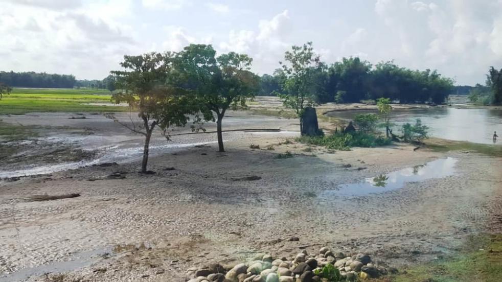
Late Kartik Pegu, grandfather of Bipin Pegu of Jiadhal Chariali village under Dhemaji Revenue Circle of Dhemaji district in northeast Assam prepared his own burial site during early 1970s on the bank of Jiadhal River. The site, a paddy field, has been owned by the Patir family of the village near the railway bridge over the river. Kartik Pegu was buried there when he died in 1976 and a tombstone was built in his memory. After that in 1985 Bilapson Pegu, Bipin’s father, too was buried on the same site and another tombstone was placed in his memory close to that of Kartik Pegu. Now Bipin Pegu (47), a college graduate and a local peasant with three children wishes him to be buried on the same plot of land when he dies. But on the evening of 16 September, 2019, his wishes for final rest close to his near and dear ones were shattered when Jiadhal River suddenly surged with overflowing water submerging the tombstones of Bipin’s immediate ancestors. He has never seen them being under water so far. Continue reading “The floods of Jiadhal River in Assam”→
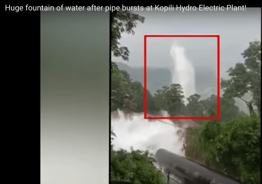
The 275 MW Kopili Dam Power House of NEEPCO (North Eastern Electric Power Corporation Limited, a Union Ministry of Power Underaking) in Assam suffered major disaster on Oct 7, 2019. The penstock pipe that takes water from the Umrangso dam to the hydropower house burst during early hours in Assam’s Dima Hasao (earlier called North Cachar Hill) district, and massive quantity of water erupted, a lot of it entered the power house, where four employees of NEEPCO are feared to have been trapped/ washed away[i]. A large portion of the Kopili Hydro Electric Plant was also inundated and a temporary bridge was also washed away[ii]. Some videos of the situation are also available.[iii]Continue reading “Major disaster at Kopili Dam of NEEPCO in Assam in 2019”→
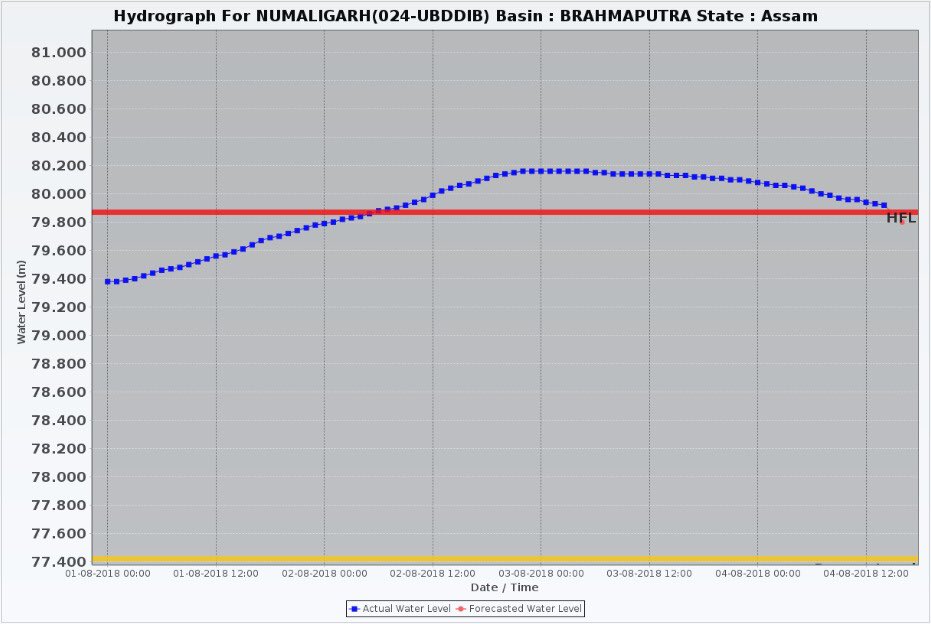
When Dhansiri river broke the highest flood level mark at Numaligarh site in early hours of Aug 2, 2018 in Golaghat district in Assam, it was not only completely out of the blue, the whole episode was unprecedented.
The earlier Highest Flood Level of Dhansiri River at Numaligarh was 79.87 m. The new HFL, it seems, was 80.18 m, full 31 cm above the previous HFL. This is rather rare, normally the new HFL would be a few cm higher, not almost one third of a meter. Secondly, the water level remained above 79.87 cm, the old HFL, for over 60 hours. This is also unusual, normally the water level rarely remains above HFL for more than a day or so. Thirdly, the earlier HFL was achieved on Sept 24, 1985, so this sudden episode of flood was breaking 33 year old record. Continue reading “Role of Doyang Dam in bringing unprecedented floods in Golaghat”→
The second wave of floods (first wave came in around May 20-24) this year inA North East India is affecting Tripura, Mizoram and mainly Barak Valley in Assam. Worryingly, while CWC flood forecast site shows water level reaching unprecedented levels in Manu river at Kailashahar in North Tripura District, CWC seems to have NO flood forecasting site in Mizoram. At Matizuri site in Hailakandi district in Barak Valley in Assam, the Katakhal river also approaching its highest ever flood level. In Bangladesh too sites like Amalshid have crossed the HFL. Continue reading “Floods in Tripura, Mizoram, Barak Valley in June 2018”→
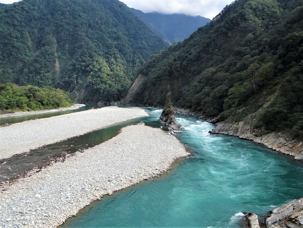
Above: Lohit River, Parshuram Kund on the right. Photo: Parineeta Dandekar
Assam, Arunachal and the North East India, West Bengal and Bangladesh are riverine entities in many ways. Ancient rivers flowing through this landscape have moulded not only the mountains and the silt-heavy banks, but cultural identity of the region itself. Rivers permeate through the literature, folklore, songs, poems, cuisine, even dressing… Bhupen Hazarika, the Bard of the Brahmaputra, likened the red ripples of the Assamese Gamcha (red and white stole) to the braided filigree of the Red River. When Guwahati University opened on the banks of Luit, Hazarika sang “Jilikabo Luiter Paar”..Banks of the Luit will Shine. Rivers stood for revolution as they stood for Love.. Jyoti Prasad Agarwal wrote“Luitar Parore Ami Deka Lora.. Moribole Bhoi Nai.” (“We are the youth from the banks of the Luit/ We are not afraid of death”). Older poets like Parvato Prasad Baruah wrote entire books full of poems of Luit and today modern poets in Assam like Jeeban Narah link their creative processes inextricably to rivers. Continue reading “‘Banks of the Lohit will shine’: Glimpses of a free-flowing river”→
In the morning of Aug 11, 2017, while checking my daily morning routine sites, I saw the sudden appearance of purple patch (signifying rainfall in access of 175 mm rainfall in previous 24 hours) on NASA daily rainfall accumulation map for Indian subcontinent.[i] The purpose patch covered parts of the West Bengal, North East Indian and Bangladesh. I was taken aback, but it was not very unusual to see in the peak of monsoon. So as we usually do, I took a screenshot and put up on SANDRP FB page with a warning that this could lead to floods. I did not realize that this was the beginning of an unprecedented wave of floods for these regions that may extend to Ganga basin as I write this. Such purple patches generally disappear in 24 hours, since the rains do not last to long. However, in the case of current phase, not only the purple patch has last now for 42 hours, it has extended to the west, all along India Nepal region along the southern boundary of Nepal. Continue reading “Brahmaputra basin faces unprecedented flood wave in Aug 2017”→
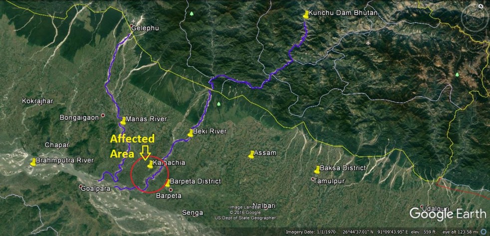
Above: Google Map showing relevant locations (Map by Bhim Singh Rawat of SANDRP)
Several media reports have alleged that sudden water releases from Kurichu Dam in Bhutan has led to floods in Beki and Manas rivers in Assam on Oct 13, 2016 (Thursday), affecting thousands of people in Barpeta district & also reportedly Baksa district. This is not the first time that Kurichu water releases have led to this kind of situation, it has happened in the past including in 2004, 2007, 2008, 2009 (150 villages affected[i]), among other instances. The Indo Bhutan joint mechanism, established in 2004-05, following the July 2004 floods, has clearly failed to effectively address this issue. Continue reading “Bhutan’s Kurichu Dam releases floods Assam, again in 2016”→
“The actual construction costs of large dams are too high to yield a positive return” this was the unequivocal conclusion of a recent study done by a group of experts from Oxford University on dams around the world[1]. Similar conclusions can be reached from a recent analysis done by SANDRP on five large irrigation dam projects from northeastern region of India, where project costs have increased as high as 35 times from its original costs and projects are under construction for 35 years but yet not completed. The Oxford study which has assessed 245 large dams built between 1934 and 2007 in 65 different countries in five continents, including 97 hydropower projects, 59 irrigation projects and 89 multipurpose projects with hydropower component, had identified enormous cost and time overrun as a major problem with large dam projects.
SANDRP had recently done an analysis (https://sandrp.wordpress.com/2014/03/19/lack-of-transparency-and-accountability-remains-the-norm-of-functioning-for-mowrs-advisory-committee/) of the decisions of the Advisory Committee in the Union Ministry of Water Resources for consideration of techno-economic viability of Irrigation, Flood Control and Multi Purpose Project Proposals (TAC in short) for North East India. This analysis covered decisions taken by TAC from 95th meeting of January 2009 to 122nd meeting of December 2013. Within these five years, TAC has given clearance to 38 projects in North East India out of which major number of the projects i.e. 26 are flood and erosion control projects. Rest of the 12 projects includes 6 irrigation projects, 3 barrage projects and 3 multipurpose projects. All these 12 projects involve irrigation as a major component.
Among the 12 projects, five projects draw specially attention because of the humongous cost escalation and time overrun in the construction of these projects. But this focus on five projects out of twelve should not be taken as an ‘All is well’ certificate for the remaining seven projects. There are significant issues with those projects as well but from the perspective of time and cost overrun, these five projects present a very critical picture.[2] Besides, all the five projects discussed here are under construction projects. TAC had paid little attention to these critical issues and therefore very little information is available in the TAC meeting minutes regarding the five projects discussed here. In this analysis, along with details cost and time escalation other important issues related with the projects have been brought together. Three out of these five projects are located in Manipur where as two are located in Assam.
Starting with the three projects from Manipur, the table below summarizes the cost incurred in these three projects. All these projects are age old projects and how much benefits will be acquired from them once there construction is complete, still remains uncertain.
Name of the Project
Year of Starting
Original cost
Considered in 2009
Considered in 2012
Khuga Multipurpose Project (Major- Revised)
1980
15
381.28
433.91
Dolaithabi Barrage Project (Medium – Revised)
1992
18.86
251.52
360.05
Thoubal Multipurpose Project (Revised)
1980
47.25
982
1387.85
Total (all costs in Rs Crores)
81.11
1614.8
2181.81
Khuga multipurpose project was first considered in the year 1980 when the cost of the project was Rs 15 crores. 1. The Khuga multipurpose project is located near Malta village in Churachandpur district of Manipur, at least 10 km from the district headquarter. The project was to irrigate 15,000 ha of land, provide 10 million galons for drinking water and have installed capacity of 7.5 MW hydropower. The Khuga (considered in the 110th and 115th meeting of TAC) project witnessed cost escalations of 25.42 & 28.92 times respectively from its original cost.
Map of Khuga multipurpose project; Source: India WRIS Wiki
In the 115th meeting of TAC held in July 2012, the completion deadline of Khuga multipurpose project was stated as March 2013 which implies that it would take 33 years only to complete the project. The minutes of the 115th meeting stated “The project authorities indicated that the increase in cost was due to frequent blockades and law and order problem in the project area, as a result Project authority were unable to obtain construction materials like cement, steel etc, in time, which in turn slowed down the progress of the project significantly. Regarding revised target date of completion, the Project authorities informed that land acquisition had been completed and the project would be completed by March 2013.”
We came across some of very crucial issues about these projects discussed in detail in the Manipur based website Manipur online, Hueiyen Lanpao[3]. These issues were very much related with the viability of the Khuga project but none of these issues found any mention in the TAC meeting discussions. The project proponent seemed to have completely ignored these issues, some of these are given below.
The Khuga project is reported to be inaugurated by Congress chairperson Sonia Gandhi in November 2010.
This project was visualized to solve the irrigation, drinking water and electricity problem of Churachandpur district in particular and Manipur in general since agriculture is the main livelihood option of the region.
But, in terms irrigation it seemed unrealistic to many since Churachandpur is a hill district where jhum cultivation is practiced. In fact an inspection of the main right canal of the Khuga multi-purpose project showed the very sorry state of the canal.[4] The inspection led by an ex-Minister N Mangi came to the conclusion that the canal had never provided any irrigation to nearby paddy fields.
An audit report of Khuga multipurpose project of March 1999 on the performance review of the dam had stated “Since 1984, the IFCD, Manipur, carried out construction work on 25.37 km of canal over an area of 40.27 hectares of forest land in Dampi reserve forest without obtaining the required clearance for diversion of forest land. Barring the unaccounted environmental destruction (that still continues) the overall concept of the multipurpose Khuga Dam project in itself was unpractical and paradoxical.”[5]
Regarding drinking water, people in the area when faced with drinking water scarcity, were not sure whether the water reserved in Khuga dam would qualify as good enough for drinking. People of several villages living in the vicinity of the dam had reported that stagnant water actually smells.[6]
The electricity generation component had been scrapped totally even after the power house was reported to be completed by almost 80%. It was said that there were flaws in the design of the Khuga multipurpose project right from the beginning and the electricity generation was not a viable option. It was learnt that the power component was planned and designed without studying its operational feasibility and the power component can be operated for only about 3 or 4 months in a year when there is excess water.
There was also a report that a Joint Action Committee on Khuga Dam visited the national capital and submitted a petition to Deputy Chairman of Planning Commission demanding an expert team to investigate the execution of the project.[7] The Joint Action Committee also demanded that the 1.5 MW electricity for the people of Churachandpur district and compensation and rehabilitation money to the affected the villages should be cleared. None of the above, even the petition submitted to the planning commission was not mentioned in the minutes of the TAC meeting.
Dolaithabi Barrage Project was first approved by the Planning Commission of India in 1992 with a cost of Rs 18.86 crores to be constructed in Imphal East district of Manipur.[8] 22 years have passed since then, but the project is yet to be completed. The cost of the project has increased 19 times from its original cost when it was considered in the 115th TAC meeting held on 24th July 2012. In that meeting price escalation, change in design on the basis of model studies, detail examination of the project proposal by the CWC field unit had been cited as the reasons for increase in costs of the project. But there was no question on why the design of the project had to be changed 20 years after the project had started. TAC meeting minutes did not mention any completion year for the project, but state Chief Minister Okram Ibobi Singh in an inspection tour to the project site in October 2012, had announced that this project would be over by March 2014.[9] This clearly sounds unrealistic.
Location map of Dolaithabi and Thoubal project. Source: India WRIS Wiki
Thoubal multipurpose project was first considered by Planning Commission in the year 1980 and the original cost of the project was Rs 47.25 crores. The project is still far from completion and witnessed huge cost escalations. From 2009 to 2013, the Thoubal multipurpose project was considered in two meetings. In the 101st TAC meeting, when this project was considered the cost escalation was already 20.78 times the original cost. As per minutes of the 115th TAC meeting, the cost by then was 29.37 times higher from the original cost. The Thoubal project was also considered in 123rd meeting held on January 30th, 2014 where the projected cost was Rs 1694.27 crores. This is a 35.86 times increase in costs from its original cost. It is interesting to see that in the minutes of the 115th meeting the reasons provided to justify the delay in the construction of Thoubal Multipurpose project are exactly same as those given for Khuga multipurpose project.
Dhansiri irrigation project in Darang district of Assam is another glaring example of mind blowing time and cost overrun. This project was discussed in the 119th meeting on 29th August 2013 for consideration of cost of Rs 567.05 crores. This project started in 1975 and the original cost of the project was Rs 15.83 crores as per the information available in Assam State Irrigation Department website.[10] The same website states that project is supposed to be completed in 2010, 35 years from the time it started. But in the 119th TAC meeting March 2015 was stated as the new completion target. This implies that the cost of the project has increased by 35.82 times over a period of 40 years but even after that the advisory committee accepts proposal without much scrutiny or enquiry. There was no detailed assessment of the reasons for time and cost overruns (there is no question of delay due to clearances or agitations here) or on whether this project which will take 40 years just to complete will be viable or not.
Dhansiri irrigation project command area: Source: India WRIS Wiki
The project proponent stated that due land acquisition and law and order problem the project has not been completed and the TAC seemed to be contended with this. But the minutes of the 119th meeting also showed that major components of the project were in advanced stages of construction with 93% of barrage work, 99% of the canal works and about 83% of works in the distribution system completed. There was no detailed assessment of any of these aspects.
Champamati irrigation project in Chirang district of Bodoland Territorial Area District (BTAD), Assam presents a very unique case. This project started in 1980 with an original cost of 15.32 crores. It was discussed in 103rd meeting of TAC held on 11th March 2010 with a revised cost of 309.22 crores which is clearly a 20 times increase from the original cost. This was 30 years after the project had started and referring to the observation of the Chairman, TAC minutes stated “both physical and financial progress of the work was rather going on a slow pace. He enquired to know whether there was any land acquisition problem persisting or not.”
Map of Champamati irrigation project command area. Source: India WRIS Wiki
Replying to this, the project authorities had stated that “the delay was mainly due to lack of fund and land acquisition problem. However, the main canals had been completed by about 80% while distribution system completed upto 30% which is likely to be completed in another two years.” But in the list of major/medium schemes in the website of Irrigation department, Govt. of Assam the proposed year of completion of this project has been mentioned as 2009.
But in midst of these tall claims of project completion, what is the present status of this irrigation project cannot be confirmed. There is little information available on this project in the internet and from those it can be clearly said that the project was not completed till the mid of 2013. In a news report titled “Centre worried over Cost overruns in old irrigation projects in NE” published in The Sentinal on 26th August 2013 the delay in construction of Champamati irrigation project was also highlighted. On other hand an earlier report “Irrigation scheme damned by delays” published in the Telegraph on 21st August 2006, had indicated that this project had substantial amount of construction left to be done “Till now, only the sluice gate (headwork) of the Champamati irrigation project has been completed, sources said. Of the 37 regulators, only eight are complete, of the 120 canal falls only 20 are complete, while 72 cross-drainage systems have been completed out of a total of 270. Of the 197 bridges, just 50 are finished. The earthwork of the main canal and the branch canal are also incomplete, with only 97.67 km out of 145.95 km finished.”
How much benefit these projects will do to the people of India’s Northeast is the question which may appears in the minds of many after going through this analysis. After such humongous in costs and time overrun, the benefits expected to be derived from these projects, would hardly justify the costs incurred. Similar concerns were raised by the representative of the Planning Commission regarding Dhansiri Irrigation project “the benefit cost ratio of the project was 1.2 and any further escalation in cost would result in the project becoming techno-economic unviable.”
Whether these projects can actually deliver what had been promised remains uncertain at best. From the history of Khuga project, it is very clear that the promises are never fulfilled and the benefits never reached the people. In fact the Khuga project is also an example of how the expected benefits of the project never become a reality even after completion of construction. The benefits from irrigation largely remained on paper.
This is the case with the several other irrigation projects in northeast. The case of Loktak Lift Irrigation project in Manipur can be cited here about which the minutes of the 122nd TAC meeting (20th December 2013) stated “Loktak lift irrigation project was commissioned in 1986 with an original command area of 24000 ha and 40000 ha as annual irrigation. Due to scarcity of funds from State Government the normal repair and maintenance could not be taken up and as of now the annual irrigation has reduced to 1800 ha.” This is possibly indicative of how much irrigation benefits have actually been accrued from irrigation projects.
Functioning of TAC Barring the cost and time overrun of these projects, the functioning of TAC also needs to be looked into. The Advisory Committee of MoWR very much works like a rubber stamping committee, clearing everything that comes to it. A reading of the minutes of its meetings reveals that there are hardly any critical questions asked on merits of the projects and for the massive delay and cost escalations that most of the considered projects suffer from. Nor is there any discussion about the performance of the projects. Considering the importance of TAC in India, we believe the committee needs to be more serious in performing its duties. It needs to question the merits and need of a project before clearing and need to do performance evaluation. It should no way become a clearing house for projects. Effective steps need to be taken to ensure that the functioning of this committee becomes more transparent, participatory and accountable. SANDRP has written letters to the concerned authorities in this regard, but we are yet to see an effective change.
Parag Jyoti Saikia (with inputs from Himanshu Thakkar) (meandering1800@gmail.com)
The state of Assam in the northeastern India annually bears the brunt of floods and where embankment construction and repairing seems like permanent affair. Displacement of people living on the banks of rivers due to river bank erosion is another major issue here. The braiding and meandering river Brahmaputra and its tributaries continue to erode the banks rapidly. The Brahmaputra is well known for the rate in which it erodes. Among the places in the path of the river where the brunt of erosion has been felt severely include the following:
– Rohmoria and Dibrugarh town in Dibrugarh district,
– Matmora in Dhakukhana subdivsion of Lakhimpur district,
– Majuli and Nimati Ghat in Jorhat district,
– Lahorighat in Morigaon district and
– Palashbari and Gumi in Kamrup district.
Map of areas taken up for erosion protection in Assam. Source– Assam 2011, A Development Perspective, published by Planning and Development Dept., Govt. of Assam
SANDRP recently traveled to Matmora and Nimati ghat, two of these areas.
Bearing the Brunt of Erosion Silently Once a large village now only the name Matmora remains. Locals show us towards the middle of the river, to indicate where the village used to be. The rate of erosion is such that the Brahmaputra dyke from Sissikalghar to Tekeliphuta (popularly known as Sissi-Tekeliphuta dyke/embankment) takes the shape of a bow for nearly five kilometers at this place. From 2010, Matmora became very significant in the embankment history of India since country’s first embankment using geo-textile technology was constructed here. This was constructed at the bow shaped eroded line using geotextiles tubes. These tubes were filled up using water and sand from the banks of the river. This five kilometer embankment became a part of the Brahmaputra dyke from Sissikalghar to Tekeliphuta which is 13.9 km long. For the state government and Water Resources Department (WRD) of Assam, Matmora geotube embankment is a story of success of preventing floods and erosion. But what we saw in Matmora presents a different picture.
At Nimati Ghat, the river Brahmaputra is eroding its banks ferociously and people are intimidated by the river. A local person whose village used to be nearly two kilometers from the present bank line, told me, “Nothing can stop Baba Brahmaputra from claiming what he wants”. At Nimati Ghat, the Water Resources Department (WRD) is doing anti erosion work using geo-bags.
Funding for Embankments in Assam The total length of embankments in Assam is 4448 km as stated in a debate in the Legislative Assembly of Assam in 1998. Even though the present length of embankments is not known, it is very clear that the state of Assam continues to construct of newer embankments. In a recent analysis by SANDRP, it was found that the funds continue to increase for construction of embankments in the state. In five years from January 2009 to December 2013, the Advisory Committee in the Union Ministry of Water Resources for consideration of techno-economic viability of Irrigation, Flood Control and Multi-Purpose Project Proposals (TAC in short) had given clearance to projects worth Rs 1762.72 crores. A detailed list of these sanctioned projects can be found in Annexure 1 below.
Matmora Geo-tube embankment after its construction in 2010. Source– Assam 2011, A Development Perspective, published by Planning and Development Dept., Govt. of Assam.
Has Geo-tube been helpful for the people Between January 2009 to December 2013, the Brahmaputra dyke from Sissikalghar to Tekeliphuta, was considered twice by the TAC. The committee in its 95th meeting on 20th January 2009 accepted the project titled “Raising and Strengthening to Brahmaputra dyke from Sissikalghar to Tekeliphuta including closing of breach by retirement and anti-erosion measures (to protect Majuli and Dhakukhana areas against flood devastation by the Brahmaputra, Lakhimpur district, Assam). The estimated cost of this project was Rs 142.42 crore and its project proposal envisaged – (i) Raising and strengthening of embankment for a length of 13.9 km, (ii) Construction of retirement bund with geo-textile tubes of length 5000 m. (iii) Construction of 2700 m long pilot channel.
Geo-tube embankment in Matmora, three years after construction. Photo: SANDRP.
Protection work of the same dyke was considered in the 117th meeting held on 21st March 2013 under the proposal for “Protection of Brahmaputra dyke from Sissikalghar to Tekeliphuta at different reaches from Lotasur to Tekeliphuta from the erosion of river Brahmaputra Assam.” The estimated cost of this project was Rs 155.87 crore. According to the minutes of 117th TAC meeting, the scheme envisaged “restoration of existing embankment in a length of 15300m at upstream and downstream of existing geo-tube dyke, Sand filled mattress in a length of 15604 m at river side slope, geo-tube apron length of 7204 m and Reinforced concrete porcupines as pro-siltation device at different reaches to prevent floods and erosion in Dhakukhana Civil sub-division of Lakhimpur district and Majuli sub-division of Jorhat district.” In the same minutes,while referring to the previous project proposal of 95th meeting the minutes stated that, it “was taken up primarily for closure of breach in the existing embankment including raising of embankment around the breach area only. The proposed works in the present scheme were in the same river reach and these would be required to protect the bank from further erosion and provide flood protection.”
This clearly shows that the geo-tube embankment in Matmora cannot be called a success. Government documents which showed that major part of the Brahmaputra dyke from Sissikalghar to Tekeliphuta remained vulnerable even after the construction of the geo-tube embankment. In fact submitting a proposal for the whole Sissi-Tekeliphuta embankment at first and later saying that the money was spent in constructing a smaller part of the embankment also raise questions. The time gap between the two proposals also raises questions. If the whole money from first proposal was to be spent in constructing only a part of the embankment, why was it not stated clearly in the first proposal? In fact, this was not stated in the first proposal and second proposal reflects that the first project failed to achieve the objectives. If the first proposal was indeed only for part of the embankment, why the proposal to strengthen the larger part of the embankment took 5 years to appear before the committee? The latter proposal also did not mention about the breach which swept away a large part of the Sissi-Tekeliphuta embankment from Jonmichuk to Amgiri Tapit under Sissikalghar and Jorkata village panchayat. According to the local people this breach occurred in the morning hours of 25th June 2012. The photo below shows the breach happened at the Jonmichuk end.
The breached area of 2012. This photo is taken from the new embankment and the lake formed at this spot can also be seen. Photo – SANDRP
Jonminchuk area is nearly 15 km upstream of the geotube embankment in Matmora and part of the Sissi-Tekeliphuta embankment. A new embankment of nearly four kilometer long is being constructed at this place but the remnants of the old embankment still exist. The embankment was breached for nearly 3 kms and the water which entered the fields during that time could no longer go out and a large lake has been formed at this place, see the photo. It was surprising to see people living in the patches of the old embankment.
In the downstream, right from the point where the geo-tube embankment ends, the condition of the Sissi-Tekeliphuta embankment is pathetic. There were cracks in the embankment and water seepage has almost shattered the embankment. The embankment was in need of urgent repairs.
Condition of the Sissi-Tekelphuta embankment at the end point of the geo-tube embankment towards the village side. Photo – SANDRPSissi-Tekelphuta embankment at the same spot mentioned above towards the river side. Photo – SANDRP
Besides, one does not have to travel far to find erosion in the downstream of the geo-tube embankment. After travelling, less than three kilometers from the end point of the geo-tube embankment, rapid erosion was observed at the place where the Matmora and Tekeliphuta ghats join, due to low water level. This joint ghat is more than a kilometer from the toe line of Sissi-Tekeliphuta embankment but seeing the rapidity of the erosion the locals opine that the river would reach the toe of the embankment within this monsoon. It was difficult to believe that the river can erode so fast, until a young man pointed towards a black line in the middle of the river and said that that area which now seemed to be char/sand bar used to be his village three years back. He with his family now live beside the embankment. In this ghat we also witnessed that spurs constructed from the embankment inside the river, mainly to divert the flow of water, have been eroded as well.
The Spur has also been eroded. Photo – SANDRPErosion at Matmora-Tekeliphuta Ghat. Photo – SANDRP
It is also important to note that protection of Majuli from floods was one of the main aims of the geo-tube embankment project, but there were reports of devastating floods affecting Majuli in 2012 & 2013.
After geo-tube comes geo bags With the construction of geo-tube embankments being hailed as a success by the state government, construction of embankments using geo-bags followed. Geo-bags are smaller than geo-tubes and come at a cheaper cost. Embankments on many rivers were constructed using geo-bags which were also used for erosion protection. But effectiveness of the geo-bags as protective measure to flood and erosion, still remains disputed. A news report titled “ADB, river engineers differ on geo-bags” published in Assam Tribune on 9th September 2010 reported about the difference of opinion among the water resource engineers of Assam and powerful lobby of the Asian Development Bank (ADB) for the use of geo-bags to resist Brahmaputra erosion in Palasbari-Gumi and Dibrugarh. Referring to the engineers the news report stated “They have alleged that the ADB provided 23,000 geo-bags for an experiment. They were dumped in the month of September 2009 at a 150-metre-long selected erosion-prone reach at Gumi for testing their efficacy. But, a diving observation made in the month of December 2009, suggested that the bags were not launched uniformly in a single layer as it was claimed. They were found lying in a haphazard manner in staggered heaps with gaps in between and the total distance they covered was only about 8 metres, against the claimed and required 35 metres…..The ADB then carried out another diving observation at Gumi in May last (2010) and found no bag at the site. The State WRD did not get any feedback from the ADB on this issue.”
Work of piling up the geo-bags is going on in Nimati Ghat. Photo – SANDRPStatus of the geo-bags put last year. Photo – SANDRPThe spot where not a single Geo-bag was seen. Photo – SANDRP
Nimati Ghat was the other place which SANDRP visited to find out the effectiveness of geo-bags. The work of piling up the geo-bags for erosion protection was going on when SANDRP visited the area in the second week of April 2014. The bags which were used previously for the same purpose were seen to be mostly lying in water in shattered condition. Locals told us that majority of the bags are now under water. In the eroded bank line, these geo-bags were lying without any order and in a way suggesting how the river has dealt or to say played with these jumbo bags. In this bank line, there was a stretch of nearly five meters where the river has eroded more than the other parts. At this stretch none of the geo-bags were to be seen.
There were also contradictions regarding when the present erosion protection work at Nimati ghat had started. Some of the shopkeepers of the ghat said that the work of putting up geo-bags started in February 2014. But according to the contractor in charge of the work, the work started in November 2013. Construction or repairing of embankment just few months before the advent of monsoons is one of the constant criticisms, leveled against the Water Resources department of the state and in Nimati too we heard the same complaint.
Is Geo-tube really a ‘permanent solution’ to floods? In the present discourse of floods in Assam this has become a very significant question. The local people have been fed with various information about geo-tube and most of which are wrong. The life of embankment constructed using geo-tube is of 100 years, we were told by the locals when we travelled to the upstream areas of Matmora geo-tube. This is absolutely not true. In fact, for Prof Chandan Mahanta of IIT Guwahati the scouring[1] done by the river Brahmaputra will be the major cause of concern for geo-tube embankments in the long run.
The geo-tube embankment has already faced threat of scouring right after its construction in the monsoons of 2011. It was on the morning of 14th July, 2011 when two of the apron tubes at the tail of the embankment, were launched due to increase force of water. The apron tubes were laid at the toe of the geo-tube embankment and with the increased force of water scoured at the bottom by the embankment toe line. WRD engineers flung into action and immediate repairing work was taken up at the site. According to WRD engineers this had happened because the trees which were left outside the embankment had obstructed and increased the force of water and they were immediately cut down. Concrete porcupines were also thrown into the water. Asomiya Pratidin, a regional newspaper reported this on that day but thereafter no report on this could be found. The incident was almost forgotten. When we visited the geo-tube embankment, it was observed that along the toe-line of the embankment a scour line runs for substantial length of the embankment. This clearly shows that scouring by the river has increased in this area. The news report published in Assam Tribune [2]also points out a significant problem associated with geo-bags – “The lobby is mounting pressure for use of geo-bags in the form of bank revetment. Bank revetment is generally not adopted in Brahmaputra because of many reasons. Most important of them is – it produces a permanent deep channel along the existing riverbank.”
On the issue of lobbying behind geo-tube, an interesting perspective was provided by activist-researcher Keshoba Krishna Chatradhara who coordinates ‘Peoples’ Movement for Subansiri and Brahmaputra Valley (PMSBV)’. He opines that the construction of geo-tube embankment in Matmora was an experiment, done to see whether such embankments can withstand the flood and erosion of Brahmaputra. The reason for choosing Matmora first and not other severe erosion affected places like Dibrugarh or Rohmoria, was because even if the embankment fails it won’t be as significant loss for the state compared to those places. Dibrugarh is one of the most important towns of upper Assam with a glorious history whereas Rohmoria became important for the state when Oil India Limited found oil deposits in Khagorijan[3]. Infact several local people and activists also opined that the Sissi-Tekeliphuta embankment which is on the north bank of the river was cut several times, to save the areas in the upstream south bank, mainly the Dibrugarh town. They said that in the past, before the geo-tube embankment came, whenever there was any news of water rising in Dibrugarh, there would soon be a breach in Sissi-tekeliphuta embankment. In fact considering these breaches in the larger Sissi-tekeliphuta embankment, Mr. Chatradhara opined that even if the geo-tube embankment survives the flood, erosion and breaches in future, it might become a small island in midst of a submerged land as there will surely be breaches in the rest of the Sissi-Tekeliphuta embankment.
ADB loan for Geo-textile Embankments in Assam After the construction of the geo-tube embankment at Matmora, the state government is leaving no stone unturned to make it sound like a glorious success. But it is surprising to know that, even before the Matmora embankment was commissioned in December 2010, the state government have filed proposal for two more embankment project where geo-textile would be used for construction and got it cleared. The two subprojects of Assam Integrated Flood River Bank Erosion Risk Management Project (AIFRERM) in Dibrugarh and Palashbari were cleared in the 106th meeting of TAC held on 16th September 2010. It is important to note that for the total AIFRERM project ADB is giving a loan of $56.9 million. The cost of Dibrugarh and Palashbari subprojects are Rs 61.33 crore and Rs 129.49 crore respectively. But these investments have been cleared without even doing a post-construction impact assessment of Matmora geo-textile embankment. The Palashbari subproject also included erosion protection for Gumi area through the use of geo-bags but the Assam Tribune report quoted above already mentioned about how geo-bags scheme has failed in that area.
It is important to note here that, the first geo-tube embankment has been constructed only three years back and it would be premature to give any verdict of success, on the contrary there are many signs of failure. But the state government of Assam and the Assam Water Resources department are claiming it as success without really any credible basis and than have used that self certification to go on building more embankments using geo-textile and in several occasions these plans have failed. They first should have done a detailed impact assessment of the embankment at Matmora before going on building more embankments of the same nature.
It seems the Assam government, ADB and CWC are pushing these projects to deflect attention from the failure of embankments in flood management. Such attempts won’t succeed, but it is possibly a ploy to prolong the use of embankments as a flood management technique.
Parag Jyoti Saikia (meandering1800@gmail.com)
Annexure 1
Flood and Erosion Projects approved for Assam – 2009 to 2013
TAC meeting no & date
Project
Appr. year
River/ Basin
L of Emba. (m)
Original (revised) Cost-CrRs
Benefitting area (Ha)
Decision
95th -20.01.2009
Protection of Sialmari Area from the erosion of Brahmputra
2002
Brahmaputra
NA
14.29 (25.73)
NA
Accepted
Protection of Bhojaikhati, Doligaon and Ulubari area from the erosion
2002
Brahmaputra
NA
14.52 (27.92)
NA
Accepted
Raising & strengthening Brahmputra Dyke from from Sissikalghar to Tekeliphuta including closing of breach by retirement and anti erosion measures
New
Brahmaputra
NA
142.42
NA
Accepted
96th -16.02.2009
Flood protection of Majuli Island from Flood and Erosion Ph-II & III
New
Brahmaputra
NA
115.03
NA
Accepted
Restoration of Dibang & Lohit rivers to their original courses at Dholla Hattiguli
New
Brahmaputra
NA
23.32 (53.11)
NA
Accepted partly & suggested that proposal of coffer dam, pilot channel, etc. to be put up for expert opinion
101st -30.11.2009
Raising and strengthening to Puthimari embankment
New
Brahmaputra
NA
30.23
15000
Accepted
Anti Erosion measures to protect Brahmputra Dyke on left bank
New
Brahmaputra
NA
27.97
5000
Accepted
Protection of Gakhirkhitee & adjoining areas from erosion
New
Brahmaputra
NA
19.06
20,000
Accepted
102 -28.1.’10
Emergent measures for protection of Rohmoria in Dibrugarh District
New
Brahmaputra
NA
59.91
18,000
Accepted
106th -16.09.2010
Raising and strengthening of tributary dyke along both banks of Kopili River
New
Kopilli/ Brahmputra
NA
110.72
NA
Accepted
Assam Integrated Flood River Bank Erosion Risk Management Project
New
Brahmaputra
NA
61.33
NA
Accepted
Assam Integrated Flood River Bank Erosion Risk Management Project
New
Brahmaputra
NA
129.49
NA
Accepted
110th – 20.07.2011
Protection of Majuli from Flood and Erosion Ph II & III
2011
Brahmaputra
115.03
Accepted
Restoration fo rivers Dibang & Lohit to their original courses at Dholla Hatighuli
2011
Brahmaputra
54.43
Accepted
111th – 17.08.2011
Protection of Biswanath Panpur including areas of upstream Silamari and Far downstream Bhumuraguri to Borgaon against erosion
New
Brahmaputra
167.09
Accepted
117 – 21.3.’13
Protecion of Sissi-Tekeliphuta dyke from erosion – Lotasur to Tekeliphuta
New
Brahmaputra
153000 m
155.87
153000 m
Accepted
118th – 30.07.2013
Flood management of Dikrong along with river training works on both banks embankment
New
Dikrong/Brahmaputra
105.96
Accepted
Flood management of Ranganadi along with river training works on both bank embankments
New
Ranganadi/Brahmaputra
361.42
Accepted
[1] Scour can be termed as a specific form of the more general term erosion. In case of geo-tube embankments Scour is the removal of sediment from the bottom of the geo-tubes. Scour, caused by swiftly moving water, can scoop out scour holes, compromising the integrity of a structure.
[3] See ‘Rohmoria’s Challenge: Natural Disasters, Popular Protests and State Apathy’ published in Economic and Political Weekly, Vol XLVI NO 2, Janurary 8, 2011.