During Sept 4-6, 2014 Jammu and Kashmir in North India is facing one of the worst floods. NDTV[1] has reported that these are the worst floods in 60 years (The Times of India reported that this was worst flood of the state since independence based on number of casualties.). More than 160 people have died and some 2500 villages are affected (1615 in the valley, rest in Jammu), out of which 450 are completely submerged (390 in valley)[2]. Over 10 000 people are stranded across the state. The flood has affected almost all 10 districts in the Jammu region. J&K Chief Minister admitted that the rescuers have yet to reach the worst affected South Kashmir region. Jammu Srinagar Highway has remained blocked for over three days. Several rivers have been flowing above the danger mark and most parts of south Kashmir, including Pulwama, Anantnag and Kulgam districts have been submerged. Jhelum was flowing at 30.7 ft in South Kashmir, 7 ft above the danger mark. Chenab river was also flowing above the danger mark at several places.
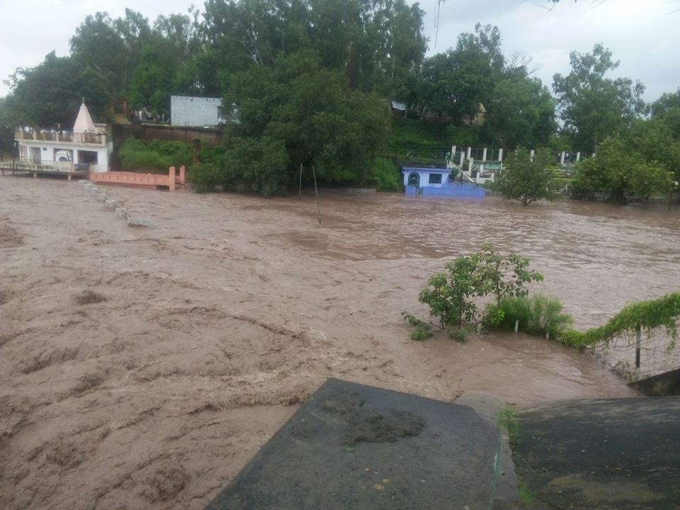
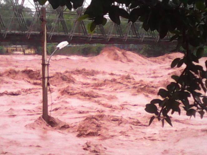
Authorities have declared the bridge over the Chenab in Akhnoor unsafe for traffic. Source: Vinay Saraf’s facebook post
Unprecedented floods Landslides triggered by heavy rainfall have damaged roads, dozens of bridges, buildings and crops. As many as 40 people went missing after a landslide in Thanamandi area of Rajouri district in Jammu region. Heavy rain in the catchment areas of Jhelum river has so far submerged more than 100 villages in the south Kashmir districts of Anantnag, Kulgam, Shopian, Pulwama, where the river was still rising, as well as the north Kashmir districts of Ganderbal, Srinagar and Badgam[3]. The flood has surpassed the 1992 memories and revived the 1959 flood memories[4].
Flood Forecast map of CWC has no sites to forecast floods in J & K
Vehicular traffic has been stopped on the Jammu-Pathankot highway due to incessant rain. Jammu is on red alert and Tawi bridge is also in danger.
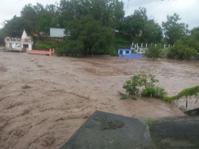
Flood image from Vinay Saraf’s Facebook post
State Finance Minister Abdul Rahim Rather said Chenab was flowing at 38 ft at Akhnoor which is four ft above the danger mark cumulatively discharging 2.75 lakh cusecs, a quantum of discharge which equals all other rivers of the state.
The situation is very grim indeed: “According to the Army, the situation in the state is as grim as it was in Uttarakhand last year.” Union Home Minister has visited the state and the prime minister has expressed grief.
VERY HEAVY Rainfall during Sept 3-6 The state received massive 250 mm of rainfall in just three days between Sept 3-4, out of its seasonal monsoon rainfall of 568 mm till Sept 6, 2014. Rainfall just on Sept 6 was 106 mm, which is unbelievable 3116% of the normal rainfall for that date for J&K.
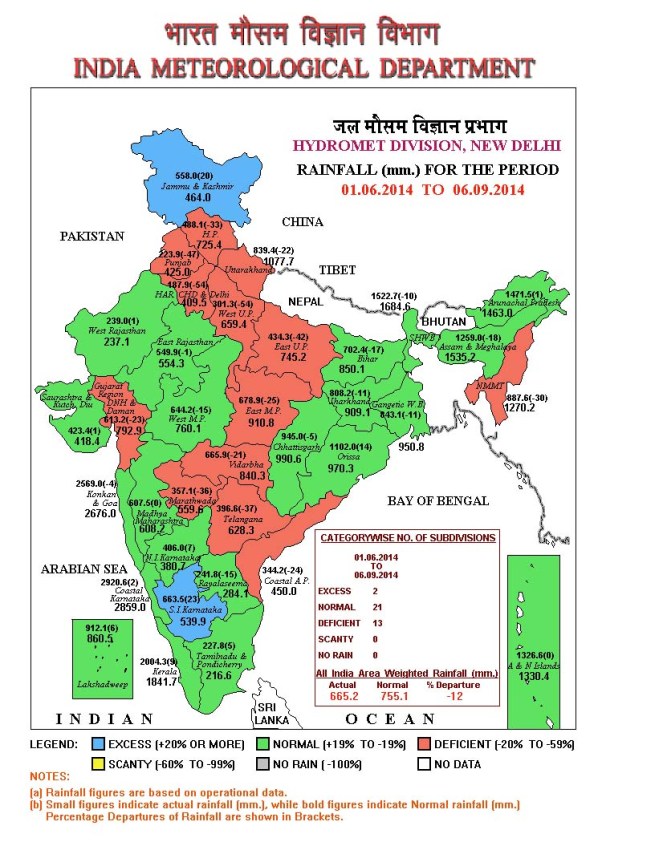
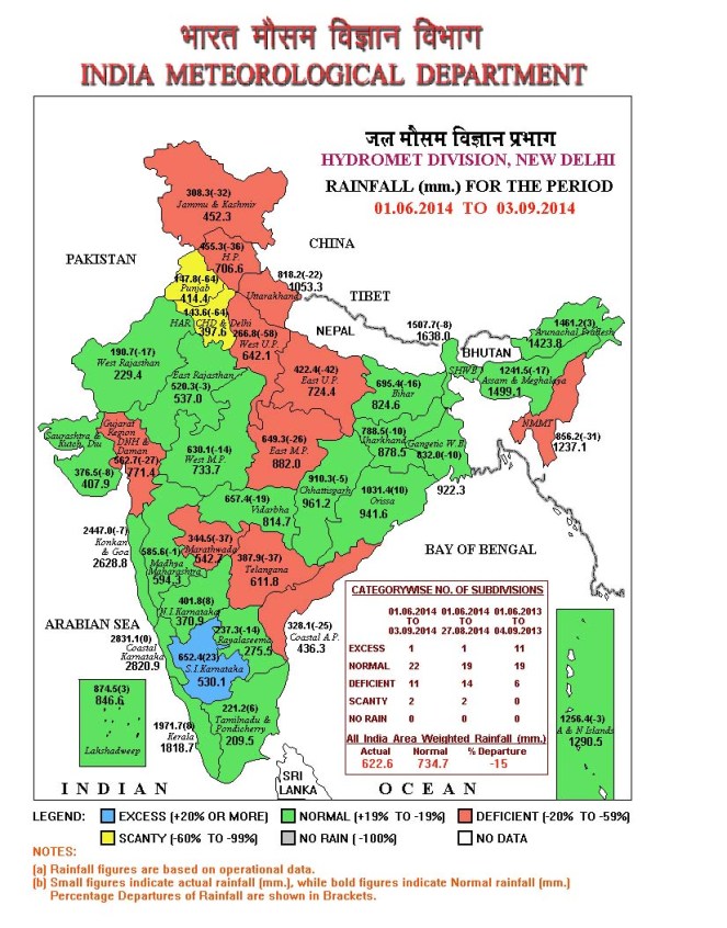
Rainfall Map from IMD showing that J&K received 558 mm rainfall till Sept 6, progressing to excess rainfall category in three days from deficit category on Sept 3, see the next map below
It can be seen from the season rainfall map see above of India Meteorology Department as on Sept 6, 2014 that J&K had received 558 mm rainfall till that date, progressing to Excess Rainfall category (blue colour code) from Deficit season rainfall of 308 mm as on Sept 3, 2014 (see IMD map below), in just three days.
IMD Map of Sept 3, 2014, showing J&K in deficit rainfall category (brown colour) with seasonal rainfall of 308 mm
CWC has no flood forecasts for J&K However, shockingly, India’s premier water resources body, Central Water Commission, responsible for flood forecasting and providing advisory to the states for tackling floods, has no flood forecast for any place in the state. The CWC’s flood forecast list[5] on Sept 6, 2014 has 18 level forecasts and 8 inflow forecasts, but NONE from J&K. CWC’s Flood forecast site has another option[6] that provides hydrographs for various rivers and location. Again for J&K it provides NO hydrographs. The options on CWC’s Flood Forecast site for list based selection[7] and map based selection[8] again has no information about Jammu & Kashmir.
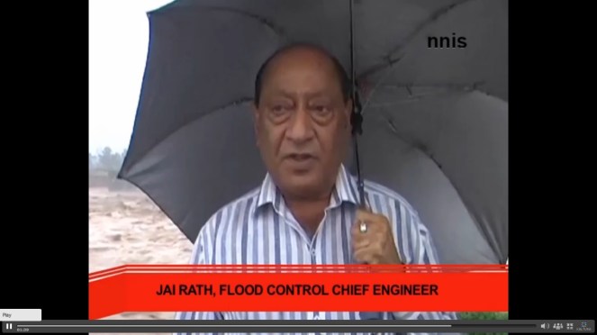
J&K Flood Control Chief Engineer called the situation Alarming. Photo Source – NNIS
This seems like shocking omission on the part of CWC, which functions under Union Ministry of Water Resources and reminds one that CWC completely failed to provide any flood forecast when Uttarakhand faced its worst floods in June 2013[9]. We hope CWC will urgently include the flood vulnerable sites of J&K in its flood forecasting and also explain to the people of J&K and rest of the country why these sites were not included so far.
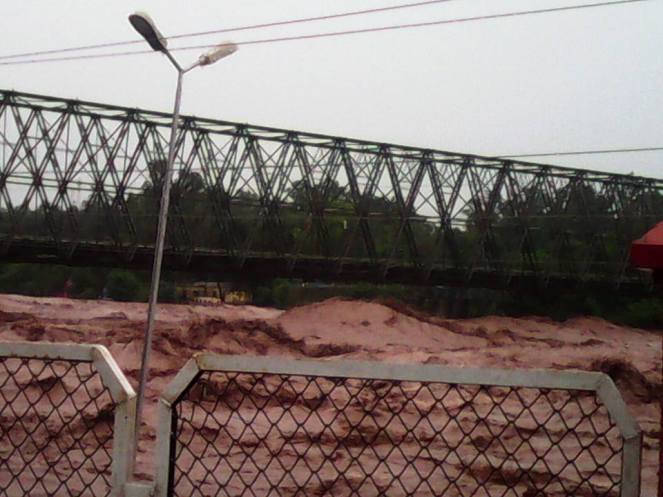
Akhnoor flood image from Vinay Saraf’s Facebook post
Mismanaged hydro projects increase the damage In this context, media has reported[10] that Dulhasti Hydropower project on Chenab river decided to open its flood gates DURING the worst flood period, which lead to further increase in flood levels in the downstream areas: “Release of water by NHPC dam is expected to increase the levels of the Chenab massively between Kishtwar and Ramban. Surged level can lead to submergence of the highway.” Such additional floods could have been avoided if the gates were kept opened in anticipation of floods. Such opening of gates during the floods can lead to catastrophic consequences for the downstream areas as happened in case of Srinagar Hydropower project in Uttarakhand in June 2013.
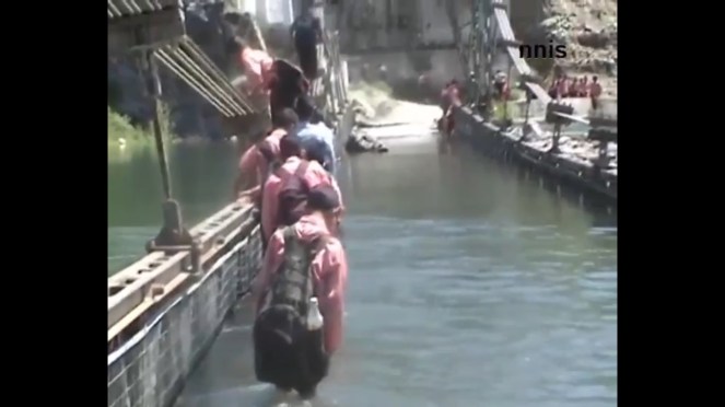
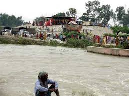
Kids crossing flooded bridge in flood hit J&K Photo Sources – NNIS
MoEF’s wrong decisions The Union Ministry of Environment and Forests have been clearing hydropower projects in the Chenab basin even without proper social and environment impact assessment as was evident in case of Sach Khas project most recently. As SANDRP pointed out in a submission to the Expert Appraisal Committee[11], the EIA and public hearing process of the Sach Khas HEP has been fundamentally inadequate and flawed and yet without even acknowledging the issues raised in this submission the EAC has recommended approval of the project. This is bound to be legally untenable decision. Such decisions by the EAC and MoEF are likely to add to the disaster potential in Chanab and other basins in J&K. There is also no cumulative impact assessment of such massive number of big hydropower projects any basins of J&K.
It is well known, as witnessed in case of Uttarakhand in 2013, that hydropower projects hugely add to the disaster potential of the vulnerable areas. We hope the J&K and central governments make this assessment on urgent basis and we hope the apex court does not have to intervene for such assessment as the Supreme Court had to do through its order of Aug 13, 2013 in case of Uttarakhand.
SANDRP
POST SCRIPT: This is one possible fall out of this, also flashed by several newspaper and following CWC questioned by media: http://www.cwc.nic.in/main/webpages/Flood%20Forecasting%20in%20uncovered%20Himalayan%20and%20interstate%20inflow%20forecasting%2011092014.pdf
Stumbled upon this on January 14, 2015. Hope the government will be now implementing this.
Read the article by Thakkar and Dandekar[1] on sediments with great interest. The basic duty assigned by nature to any river is to build land (nearest word is delta formation), transport the water falling on its catchment to the master drain or the sea and keep the ground water level intact besides saving its fertility. Scriptures define river in many other ways. The basic reason for that was, probably, to discourage tempering with the river. The rivers flow for the good of all the living beings (paropakaray bahanti nadyah), they are cited as an example for continuity. Our ancestors used to bless the younger ones that their name and fame will last till the rule of forests, mountains and rivers are there. There are strict restrictions about polluting rivers and the punishment is also prescribed for doing so. That provides enough food for thought about rivers to us. When we recall our rivers to grace any religious or social ceremony, the emphasis is never forgotten as to what should be our attitude towards rivers. Most of our festivals are held on the bank of the rivers (barring Karmanasa) in Bihar which is called tirthas i.e, the sacred places.
We care too hoots about our rivers now.
An engineer or a trader looks at the rivers about the profits that can be made by the existence of the rivers and they rightly use the word ‘exploitation’ which we all know what it means. As engineers, we all are trained to look into the Benefit Cost ratio and are never taught about the social costs. That is not our job. We tell the politicians where the profit and votes lie. They, in turn, tell all others that they have a team of world class engineers who have advised this or that. The implementers (the contractors) intervene in the mean while. Then there may be financers, promoters, consultants and what not, each with some vested interest or the other. Some of them are for money, some for power, some for name and fame and some for merely impressing others of their proximity with the sources of power.
Each one of them has an insurance that by the time the ill effects of their wrong doing come to the fore, they will not be there in this world. That sets the tone for discussions now.
Let us look at the physical characteristics of river water. The river water contains sediments of all kinds and their shape and size depends on the locations that they are transported to by the river water. The ultimate destination, however, is the sea. I have read considerable literature about sediments and floods and I know that at least since middle of the 19th Century, the British engineers in India have been telling that water is not the problem and it is the sediment that is responsible for flooding. This should be treated first if the floods are to be avoided.
Unfortunately, we are not taught how to deal with sediments and we read about it as a passing reference. Water flows downstream but the sediments remain where the water no more is in a position to push it further down.
Structurally, if you intercept water by a dam, the sediment will collect in the reservoir area. I had read a report of Central Water Commission a few years ago (I should be having a copy of it somewhere in my collection) wherein they had studied the sedimentation of 64 reservoirs in India but only in two of them their prediction of sedimentation was near to reality. Rest all the dams were in pathetic situation. Trap the river within embankments, the sediment will settle within the embankments and raise the bed level of the river. Kosi is a good example of mishandling of sediments. This river was flowing in 15 different channels some 60 years ago. The engineers embanked just one of these channels and forced all the water and sediments into that channel. The result is that the bed of this channel is higher than the adjoining ground. In lower reaches, the river is aggrading at a rate 12.03 centimeters every year. The engineers and the State is busy raising the embankments without realizing that they are ‘storing disasters for the future generation.’ Construct a ring bundh round a settlement to protect it from the floods of river, the sediment will settle outside the ring to the detriment of the community in future.
Many settlements in Bihar were encircled by such rings in the past. These are all a false security for the people. There is sand casting within the protected area and boats ply there during the rainy season. Some of these rings do not exist anymore because the river has wiped them out. Every step of mishandling sediments leads to a disaster situation which we do not know how to cope with and do away with the sediment.
Look at any silt laden river. It used to spread the sediments free of cost all over the area which is what we call the land building by a river. You disturb a river and this quality is lost.
Then starts the famous debate on forests. The engineers are again confused over the issue and they are not sure whether restoration of the forests can be of any use. Once the ground is saturated due to rains, the role of forests is over, they say. Fortunately such conclusions are not available freely in vernacular. I shudder to think how the masses will react to such wisdom.
I had a chance meeting with the Minister of Water Resources of Bihar before this election and he wanted me to suggest something to combat floods. The discussion boiled down to sediments and the quantity of sediments that passes through Bihar every year.
Irrigation Commission Report of Bihar (1994) talks vaguely about sediments and no inference can be drawn out of it. This may be willful that a reader may not decode the information contained in the report.
Now, if it is understood that sediments are the problem, do we know the amount of it? The answer in ‘No’.
Or, even if it is available, it is not in public domain. We keep on telling that rivers have become shallow but its extent is not known in most cases. I suggested to him that if the government was really serious about the issue, let us take cross section of the river at strategic points that the WRD must have been taking before independence or after the establishment of the Planning Commission and check what is the extent of aggradation of the river bed and what have been the change in the cross section. This will tell us the sediment retained in the river bed and give a hint about its transportation to the sea. It will also tell us that if we pursue the policy of flood control as we are doing at the moment, what will be the fate of the river after say 50 years. He very kindly phoned his principal secretary who, probably, told him that this was possible.
Two questions arise from this discussion, (i) does it require an outsider like me with little access to information that these august bodies dealing with rivers have to tell the minister what should be done to assess the sediments? And (ii) what on earth the responsible engineers of the WRD have been doing all these years? Do they know their job and responsibility well?
Former chief minister of Bihar had announced in May 2009 after the breach at Kusaha on the Kosi (in Aug 2008) was plugged that the embankment is not going to breach for thirty years, at least. Everybody interested in the Kosi issue knows that the breach had occurred because the river was pushed towards eastern embankment of the river by sediment deposition on the west and this was not given the attention it deserved.
I wonder since when the rivers have started taking command from the chief ministers. Even if they do, what will happen in thirty first year?
I am of the opinion that a peon in government is more powerful than a Noble Laureate outside for the peon can get something done through his contacts but the latter can only make a request. It is up to the establishment whether it heeds to his/ her advice or not.
In late April and early May 2012, what was usually a roaring Seti river in Northwestern Nepal had slowed to a trickle. The milky-white turbid water had turned blue and clear. And then suddenly on May 5, 2012, the flooded river laden with slurry of sediment, rock, and water surged through the Seti valley in the Kaski district, obliterating dozens of homes and sweeping 72 people to their deaths. The floods waters were upto 30 m high at places. It reminded of the sequence of events leading to Tsunami. Questions swirled about where the water had come from and how it arrived with so little warning and that too in a non-monsoon season.
NASA Earth Observatory (acquired October 7, 2013)
The abstract of the paper by Shreekamal Dwivedi and Yojana Neupane of Department of Water Induced Disaster Prevention of Government of Nepal (presented in a conference in Nov 2012 and published in Nepal Geological Society (2013, Vol. 46)) provided some details of what happened in the floods: “Comparative Analysis of the Landsat ETM satellite images of 20th April, 2012 and 6th May, 2012 revealed that the area of about 32000 square meter of the southern ridge 1.5 kilometer away from the Annapurna IV peak failed in the north western direction. The impact of descending mass of the failed mountain from 6850 meters to 4500 meters almost vertically pulverized the ice, sediment and rock. The impact even triggered seismicity at 9:09.56 AM. local time which was recorded all over the 21 stations of National Seismological Centre. The closest seismic station at Dansing which is 32 km. south west from the area recorded the high signals for 70 minutes which corresponds to the duration of the debris flow. (The seismicity was equivalent to magnitude 3.8-4 in Richter Scale.) Lab analysis of the flood water sample revealed the density of the flow as 1.88 gm/cc. Analysis of the satellite based hourly rainfall GSMaP NRT from the period form 20th April -6th May 2012 revealed that there were just 4 occurrences of rainfall which amounted less than 1 mm/hour in the source area of the avalanche. The rainfall > 6mm/hour which occurred in the Kharapani area on 4 May was localized rainfall which did not extend to the avalanche area. Lack of systematic disaster preparedness caused huge loss of life and property even though the early warning message was received from the Ultralight pilot who was flying close to the area. The avalanche triggered high intensity floods which have similar characteristics to glacier lake outburst floods (GLOFs) have emerged as a new hazard in the Himalaya.”
Now, twenty months after the disaster, experts like Dr Jeffrey Kargel, hydrologist at University of Arizona, are in a position to throw more light what happened. Dr. Kargel has concluded that it was not just one event but a series of event that combined to produce the devastation.
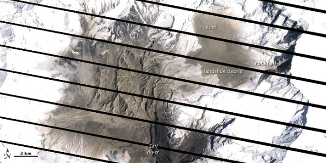
NASA Earth Observatory site describes the affected landscape as: “The landscape in this part of Nepal is shaped by a cycle of landslides and subsequent erosion. As the tectonic collision of India with Asia pushes the Himalaya upward, ice, water, and gravity, assisted by sporadic earthquakes, combine to grind the mountains down. The channel of the SetiRiver itself is cut into the remnants of a much larger debris flow, perhaps 1,000 times as big. 60 to 100 meters (200–330 feet) thick, the landslide deposits are composed of the same limestone as the peaks to the north. Likewise, the May 2012 flow left behind jagged fragments of limestone, carried from the crest of the Himalaya to the foothills in a single event.”
‘Seti’ in local languages means white, and Seti is the ‘White River’, its water is glacial white, turbid and laden with sediment.
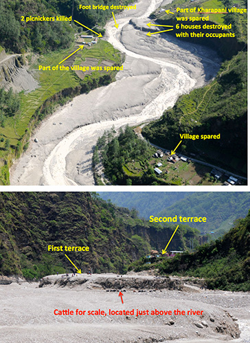
The high intensity floods in May 2012 came in waves, and the first wave alone had around a quarter of a million cubic meters of water in just a few minutes. There were about 27 waves in all over the next hours, according to eyewitnesses, so several million cubic meters of water flowed overall. As Dwivedi et al note, “The huge mass of debris along with ice chunks rushed down the river as a debris flow for 20 kilometres downstream at Kharapani in just 28 minutes (almost 12 meters/second). The flood arrived at Kharapani, where most of casualties occurred, at 9:38 AM and reached the dam of the Seti irrigation system at 10:35 AM… The high-water level at the dam weir at Pokhara was 2.15 meters. The discharge estimation based on the water mark revealed the peak as 935 m3/s (B. Poudel, personal communication). The eye-witnesses in Kharapani area reported huge ice blocks floating in the flood. They felt vibrating ground and heard very loud sound similar to flying of several helicopter together. The smell of the flood water was muddy… Kharapani was a popular spot for picnic and natural hot spring bath… Most of the causalities occurred in this area as the warning message from the Pokhara Airport tower could not reach this area”.
It is heart warming to see that many lives were saved, as Dwivedi et all write, “Capt. Alexander Maximov, the pilot of ultra-light plane of Avia Club Nepal in the morning of May 5 was in a regular sightseeing flight close to the Mountain Machhapuchhre. He noticed a huge dark cloud in the high-mountain depression (Fig. 9) and immediately turned back. He sent a message to the tower of Pokhara Airport. His quick understanding of the unusual event and timely response has saved hundreds of lives during the Seti flood of 5th May 2012. He informed the tower at 9:16 AM and the message was broadcasted through FM radio; police forces evacuated hundreds of people living and working in the bank of the Seti River. Some eye- witnesses in the field said that information about the flood was also received in Kharapani bazar by mobile calls from the people who saw the flooding in the upstream area. This message has helped many people to run to safety. However there was no organized approach of the warning dissemination in the ground.”
Video shot by Capt. Maximov from his aircraft, as the event was was happening:
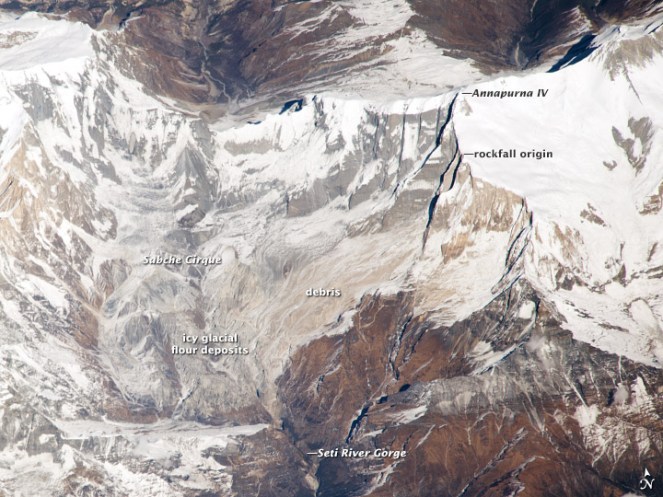
NASA Earth Observatory image (acquired Dec 22 2013)
However, the series of event started weeks before the flood with a series of rockfalls that sent debris tumbling into the SetiRiver, backing water up in the extremely deep and narrow gorge. The last of these landslides occurred just a week or so before the flood. The situation grew dire on May 5, 2012, when an unusually powerful ice avalanche and rockfall tumbled down a vertical cliff on a ridge just south of Annapurna IV Mountain peak. The total drop from the Annapurna IV ridgeline to the bed of the Seti below Pokhara is about 6,100 meters (20,000 feet) spread over a distance of only 40 kilometers. The distance between the landslide dam and sight of worst floods was about 29 km.
Prof Jeffrey Kargel, writes (http://earthobservatory.nasa.gov/blogs/fromthefield/2014/01/24/setiriverclues/), “A flash flood—what geologists call a hyper concentrated slurry because it was thick with suspended silt—had torn through some villages along the Seti River, in north-central Nepal, just north of the country’s second largest city, Pokhara. It was immediately recognized as a very deadly event, but the death toll—and a tally of those who remain missing but were clearly also killed—was not known exactly for several months. 72 souls lost. Though not large on the scale of global disasters, this event was terrifying for the fact that it seemed to come from nowhere—literally from beneath a blue sky.”
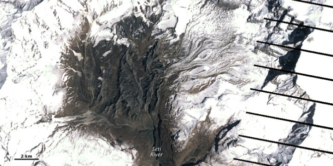
AFTER IMAGE: shows the area on May 6, 2012, roughly 25 hours after the landslide
BEFORE IMAGE: the same area on April 20. The diagonal lines are gaps in the data, due to a partial failure of the satellite.
One scenario (see: http://earthobservatory.nasa.gov/IOTD/view.php?id=78070&eocn=image&eoci=related_image) estimates that roughly 22 million cubic meters of rock broke off the slope of Annapurna IV. Colin Stark at Lamont-Doherty Earth Observatory at ColumbiaUniversity said: “There’s a drop of about 2,000 meters into the canyon, so we’re talking an enormous gain in momentum. Then I think the debris ran down the canyon at speeds upwards of 30 meters per second—a guess but what we see for the landslide itself.” Stark estimated that events unfolded in a matter of minutes with no time for a temporary dam to form.
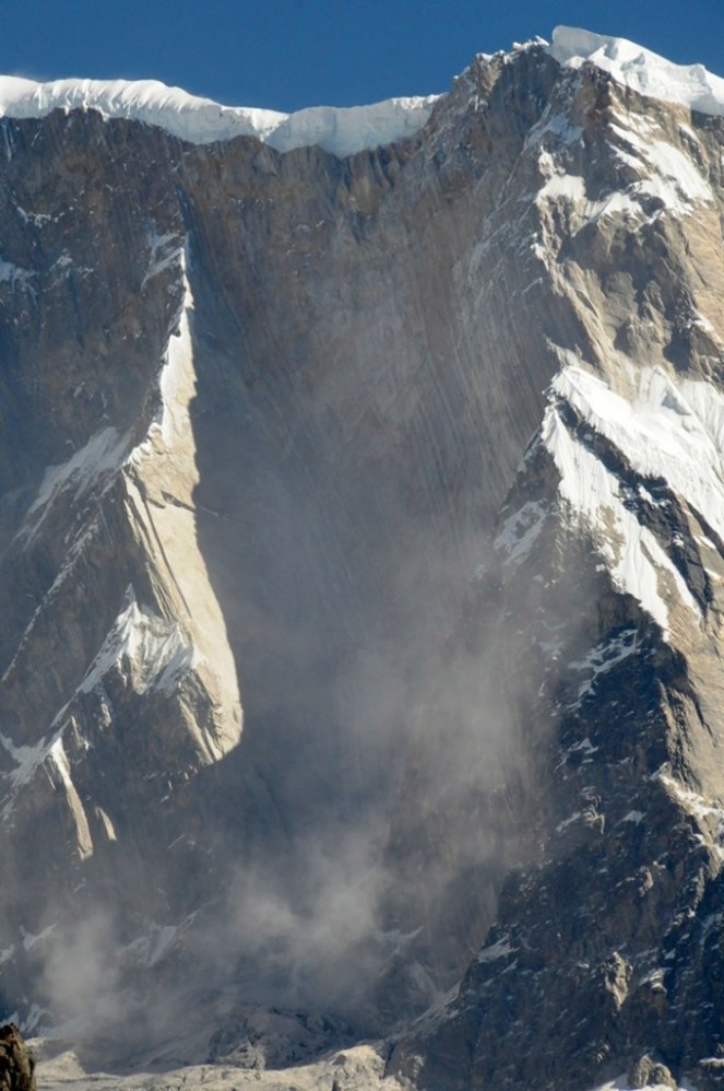
This flood appeared to behave like a glacier lake outburst flood, and the news media can be pardoned for having assumed that it was. Prof Kargel adds: “Seeing that the disaster occurred at the foot of the AnnapurnaRange, within the Greater Himalaya, probably every expert’s first thought was “glacial lake outburst flood” (GLOF), because these were common in Nepal’s Himalaya, and the news accounts of the disaster event resembled accounts of GLOFs”. However, available satellite images showed there were no such lakes. “It was, however, clearly a disaster that had its source in a high Himalayan amphitheatre-like bowl, a glacially-carved structure called the Sabche Cirque. This structure was rimmed by some of Nepal’s most famous, picturesque mountain peaks, including the storied, holy Machapuchare ( “fishtail” peak) & Annapurna IV, a 24,688 ft” mountain.
Annotated photo from Dr. Kargel
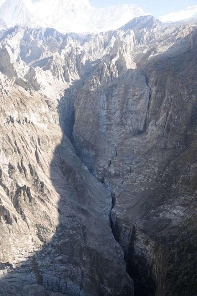
Thanks to video from winged camera of a 2 seater plane incidentally flying over the area at the time of the event, the disaster’s trigger was sourced on a ridgeline near Annapurna IV. Apparently part of this ridge—probably initially the glacier ice— collapsed, dropping ice and rock over 3000 m almost vertically onto unconsolidated rock debris (glacial moraines and ancient glacial lake silts and gravels) resting unstably in the deep bowl of the Sabche Cirque. Some of that loose debris was also swept up by the avalanche, and the mass flowed and dropped through an additional 1,500 m into the SetiRiver gorge. Indeed, the conversion of gravitational potential energy to heat could have melted roughly a tenth of the falling snow and ice by the time it reached the SetiRiver.
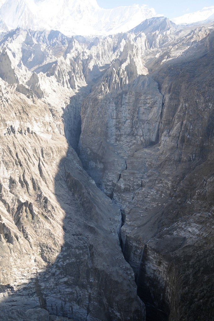
A view of the gorges and also the distant peaks of the Sabche Cirque and the ancient glacial deposits in between. The avalanche entered the gorge from the upper right corner of the scene. (Photo: Dr. Kargel)
One source seemed to be definitely involved, and that was a rockslide-dammed reservoir in the gorge. This was definitely not a GLOF, but was caused by a rockslide into the SetiRiver gorge, formation of an impoundment reservoir over a several week period due to damming of spring snow and ice melt, and then the final triggering event of the mighty rock and ice avalanche off Annapurna IV.
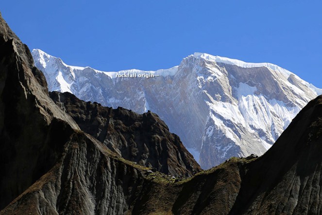
The source area for the avalanche of May 5, 2012. Annapurna IV is just off image to the upper left. (Photo: Dr. Kargel)
Warning: More such events could occur As Dwivedi et al have noted, “The southern slopes of Annapurna range have been experiencing avalanche-triggered high intensity floods also in the past. On August 15, 2003, the Madi River had experienced an unprecedented flash flood which destroyed the recently built rural road and triggered many landslides along its course and killed 5 people”.
“There are good reasons to be concerned,” Jeffrey says, “Something like this will happen again. It’s inevitable.” The Seti River Gorge is unusually prone to dangerous blockages because of how narrow and deep it is. And the same processes that triggered the spring 2012 rockfalls and avalanche are still at work. “The only question is whether future events will be as destructive or whether people in the SetiRiverValley will have absorbed the lessons of 2012 and found ways to move their homes out of the flood plain.” India should not forget that we are downstream country in Seti basin and what happens there will flow down here too.
In an earlier excellent paper on this event, Jorg Hanisch et al recommends that this event requires deep investigations and “Marsyangdi Khola, Madi Khola, Modi Khola and Kali Gandaki, all with apparent origin in the high-mountain environment of Annapurna Range (Hormann 1974; Yamanaka and Iwata 1982) should be included in the investigations… A new catastrophe of similar size would have an apocalyptic impact: about half a million people live in the valley today. A detailed investigation of the circumstances of the disaster on May 5th, especially the possible influence of global warming on the trigger of the disaster, and a reliable forecast of a potential recurrence of similar events or of even much greater scope, are urgently required. For this, the thorough understanding of the conditions, triggers and mechanisms of the huge flows in the past to compare it with the recent flood is indispensable as well.”
The proposal for a 140 MW Tanahu Seti storage project downstream of this flood event & supported by the Asian Development Bank, Japan International Cooperation Agency, European Investment Bank and Abu Dhabi Fund is questionable, says Ratan Bhandari of Nepal. Considering that the Seti River Basin is prone to such events in future, the proposal seems disastrous.
More significantly, this whole episode raises the question as to how much do we really know about the Himalayas. Uttarakhand disaster of June 2013 was a wake up call to understand the Himalayan ecosystem and its implications for future well being of the people and environment of India. However, in stead of learning any lessons, our governments in Uttarakhand (as also in Himachal Pradesh, Kashmir and North East) and at the Centre, with environmentally-challenged Mr Veerappa Moily as the environment minister, are playing into the hands of short sighted vested interests. This is also apparent in the recent decision to sanction the massive Lakhwar dam on YamunaRiver in Uttarakhand without so much as an Environmental Impact Assessment!
We still do not have full explanation for the Uttarakhand disaster of June 2013. This explanation of the Seti River Disaster in the same Himalayas, which happened just a year before the Uttarakhand disaster highlights the urgent need for more serious studies and applying precautionary principle while dealing with the Himalayas, its rivers and flood plains.
2. http://earthobservatory.nasa.gov/blogs/fromthefield/2014/01/24/setiriverclues/ This entry was posted on Friday, January 24th, 2014 at 10:34 am. See the absolutely amazing photos on the site that gives an insight into the situation in the head reaches of Seti River… possibly indicates how little we know about the catchments of our Himalayan Rivers.
7. “Cause and mechanism of the Seti River flood, 5th May 2012, western Nepal” by Shreekamal Dwivedi and Yojana Neupane, Department of Water Induced Disaster Prevention, Pulchwok, Lalitpur, Nepal (shreekamal @gmail.com), published in Journal of Nepal Geological Society, 2013, Vol. 46, pp. 11-18
8. Famous movie clip of the area, http://www.youtube.com/watch?v=Uk82ggshSKs&feature=related you can see landslide in the clip at 56-57 seconds of the movie. At this time the avalanche had not occurred yet. After taking one round the aircraft pilot has noticed the dark grey brown cloud formed by the avalanche (see the movie at 2 minute 7 seconds). This is thanks to Shreekamal Dwivedi
9. “The Pokhara May 5th fl ood disaster: A last warning sign sent by nature?” by Jörg Hanisch, Achyuata Koirala and Netra P. Bhandary, Journal of Nepal Geological Society, 2013, Vol. 46, pp. 1-10
IMPACT OF UTTARKHAND FLASH FLOODS IN MID JUNE 2013 ON LOCAL PEOPLE AT KHARADI VILLAGE (BARKOT BLOCK) IN UTTARKASHI DISTRICT RESULTING FROM A DIVERSION/ REDIRECTION OF THE YAMUNA RIVER TOWARDS POPULATED BANK OF THE RIVER DUE TO THE 8 MW GANGANI HEP. IMPACT IS ALSO THERE ON THE HEP INFRASTRUCTURE ITSELF PUTTING A QUESTION MARK ON ITS QUALITY OF CONSTRUCTION AS ON ITS SUSTAINABILITY.
YAMUNA JIYE ABHIYAAN, JULY 2013 Text by Manoj Mishra
Kharadi is a small road side market place on river Yamuna, some 40 km short of the holy shrine of Yamunotri. It is also a popular night halt site on the Char Dham Yatra route. Resultantly over the period of time a number of hotels and residential properties have come up along the road and the river side.
Redirection of the river to the left due to the project head. All Photos taken on 20 July 2013, by Bhim Rawat, Yamuna Jiye Abhiyaan
Some time in 2008-09 works, started by a pvt firm called Regency Gangani Energy Private Limited, immediately upstream of the Kharadi village for the construction of a 8 MW run of the river HEP. The works involved a diversion head, laying of pipes to convey the diverted river water and a power house around 5 km down stream of Kharadi at a place called Gangani. It is notable that the planned HEP is on the proper river Yamuna
By the year 2012, construction works had progressed to a considerable extent, when on the night of 3 August 2012 a cloud burst at Hanuman Chatti area resulted in a flash flood in the river Yamuna. Flow of Yamuna was obstructed by the diversion head of the HEP and was diverted towards its more populated left bank. This diversion swept away of around 9 hotels and residential properties of the local people at Kharadi. It also resulted in damages to the pipes laid in and near the river bed by the HEP.
If the above was not enough then on 17 June 2013, another cloud burst and heavy rains over most of higher reaches of Uttarakhand led to yet another diversion of the river and sweeping away of around 28 properties (see list at the end of this report) in the market village of Kharadi.
Washing away of structures in Kharadi some 500 m downstream from the river diversion head of the Gangani HEP by the flash flood in the river Yamuna on 17 June 2013
The Project also applied for Clean Development Mechanism (CDM) status under United Nations Framework Convention on Climate Change to get Carbon Emission Reduction Credits. Yamuna Jiye Abhiyaan and others have objected to this application at the Validation stage earlier and at registration stage now in August 2013 as the project is not only unsustainable, but its application was full of contradictions and misleading claims. The project is in any case not a sustainable Development Project, is business as usual project and hence non additional as per UNFCCC criteria. The project is also not sustainable development project, but India’s National CDM Authority, namely the Union Ministry of Environment and Forests, has never done credible assessment of this, and never rejected any application of CDM hydro projects!
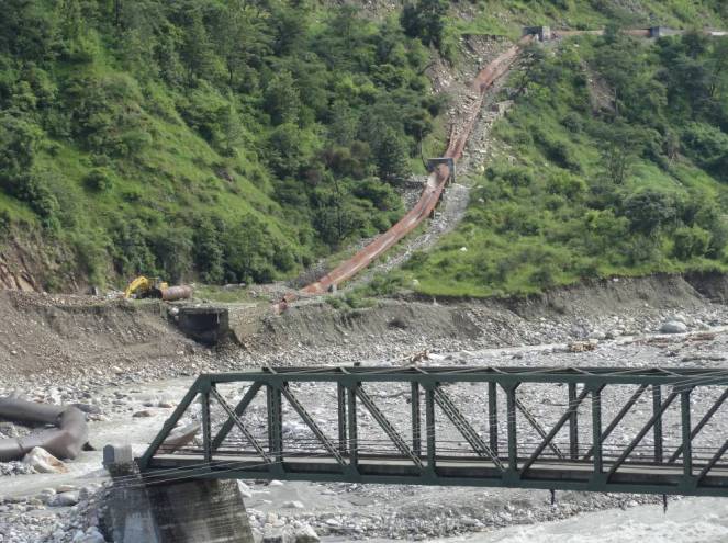
Road and structures washed away by the flash flood in the Yamuna river downstream from diversion head of the Gangani HEP.Damaged pipes (meant to carry the river water to the Gangani HEP power plant some 3 km d/s from the diversion head) and the damaged approach bridge on the river
List of Hotels and residential properties destroyed in Kharadi village by the flash floods in river Yamuna made worse due to the diversion head of the HEP upstream of the Kharadi village on the night of 16 and morning of 17 June 2013 and on the night of 3 August 2012 around 11 PM made worse (as per local people) due to the Gangnani HEP structure (head) in the river upstream of the village
Property/Hotel Owner Name Father’s Name Village Name No. of Rooms
1 Neel Kanth Hukum Singh Rawat, Sri Lal Singh Khanera Three Storey, 20 rooms
2 Unnamed Jagdish, Chandar Mohan, Ajay Sri Attar Singh Khanera 2 rooms + Provision Shop
3 Yamuna Darshan Jaidev Singh Rana Sri Jandar Singh Khanera 25 rooms
4 Bhupendar Place Rajendar Singh Chouhan, Sri Narendar Singh Syalna 12 Rooms
5 Bhupendar Palace (Joint) Gajendar Singh , Sri Narendar Singh Syalna 04 Rooms
6 Bhupendar Palace (Joint) Arjun Singh, Kesar Singh Syalna 04 Rooms
7 Amit Restaurant Jogindar singh, Sri Chandan Singh Bhansadi 05 Rooms
8 Govind Palace Janak Singh Sri Ranjor Singh Khanera 12 rooms 9 Him Darshan (August 12) Atol Singh, Sri Jai Singh Chouhan Nagon Gaon 22 Rooms
10 Naveen Palace Jag Mohan Chouhan, Sri Jhoon Singh Khanera 06 Rooms
11 Naveen Palace Man Mohan Singh, Sri Jhoon Singh Khanera 04
12 Naveen Palace Dharmendar , Sri Jhoon Singh Khanera 04
13 Vijay Restaurant Vijay Chouhan, Sri Jhoon Singh Khanera 1 Hall, 1 Cottage
14 Naveen Palace Darmyan Singh, Sri Kamal Singh Syalna 07
15 Provision Singh Jagveer Singh chouhan Sri Surveer Chouhan Khanera Provision Shop
16 Ravindar Palace Ravindar Singh Sri Budhi Singh Khanera 04 Rooms 17 Kahniya Palace Shailendar Singh Sri Shiv Singh Khanera 04 Rooms + Restaurant 18 Rana Place Kitab Singh Rana Sri Surb Singh Rana Khanera 04 Rooms
19 Residence Gabar Singh Sri Sultan Singh Khanera 04 Rooms 20 Residence Bijendar Singh Sri Sabal Singh Khanera 07 Rooms
21 Residence Brij Mohan Sri Jogolia Khanera 06 Cottages
23 Residence Chojen Lal Sri Kuta Singh Syalna 04 Rooms 24 Residence Basant Lal Sri Khelan Singh Khanera 03 Rooms 25 Residence Trepan Lal Sri Sadhu Lal Syalna 02 Rooms 26 Residence Jogi Lal Sri Jhapuliyan Khanera 02 Rooms
27 Aneesh Place Aneesh Sri Janbeer Khanera 06 Rooms
28 Residence Jendar Singh Sri Keval Singh Khanera 02 Rooms
29 Residence Praveen Singh Sri Jandar Singh Khanera 02 Rooms
30 Residence Jagendar Singh Sri Keval Singh Khanera 02 Rooms 31 Narayan Place Kendar Singh Payal Sri Ram Singh Syalna 05 Rooms
32 Residence Chain Singh Sri Rompal Singh Syalna 04 Rooms
33 Residence Ispal Singh Sri Khajan Singh Syalna 04 Rooms 34 Narayan Palace (Joint) Ranbeer Singh Sri Ghayan Chand Syalna 04 Cottage
35 Narayan Palace (Joint) Chain Singh Sri Daya Ram Singh Khanera 02 Rooms + Canteen= 02 cottage (About to fall)
36 Giri Ashram Saint Giri Kharadi
37 Trishul Hotel Kandra Singh Payal Sri Ram Singh Syalna Verandah Damaged Bold entry relates to properties washed away in Aug 2012.
NOTE:
About 25 additional Households have now (after June 2013 floods) come with in the slip zone, which can now slip or get washed away any time in the event of high rainfall or another flood.
Entire Kharadi village has now been declared as disaster affected by the District Administration.
YAMUNA JIYE ABHIYAAN, JULY 2013 (Text by Manoj Mishra)
The claim of THDC, CWC and Uttarakhand Chief Minister that in absence of Tehri dam, Rishikesh and Haridwar would have been washed away is completely baseless and unfounded, nothing but a hype. Facts show that if Tehri Dam id not exist, the water level in downstream towns may have risen on June 16-17, before the levels actually rose on June 18 (as per CWC, peak level in Rishikesh was 340.8 m and in Haridwar at 295.1 m, both on June 18), but are likely to be lower than the levels of June 18 since peak flow in Alaknanda (around 11000 cumecs) was lower than that in Bhagirathi (6900 cumecs). THDC and CWC should refrain from making such claims as they are more like adding salt to the wounds that the people of the state are now experiencing and where dams and hydro projects have played a big role.
From all accounts, it is clear that peak flood in Bhagirathi River on which Tehri dam is situated, occurred on June 16 and the peak flood in Alaknanda occurred on June 17 and not at the same time. So it is not rational to add the two peaks happening at different points of time to claim that Tehri saved downstream areas. If Tehri was not there, there could have been floods in downstream a day earlier, but that does not mean peak level would have been much higher than what was the case with Tehri Dam.
From the records available on the websites of Central Water Commission (http://cwc.gov.in/Reservoir_level.htm) and Central Electricity Authority (http://cea.nic.in/daily_hydro.html), it is clear that water level in Tehri reservoir rose from 749 m on June 15 to 776.8 m on June 18 (water levels for June 16 and 17 are not available for some strange reason), this translated to increase in water storage by 652 Million Cubic meters (MCM). THDC claims that they experienced peak inflow of 244 000 cusecs and moderated that to an outflow of 14000 cusecs. To achieve this moderation for a day would take storage capacity of around 563 MCM, so it is plausible that they achieved this moderation on June 16, when Bhagirathi was experiencing peak flow.
However, as we noted earlier, the peak flow in Alaknanda happened on June 17. THDC should make public hourly figures of flow in Bhagirathi and Alaknanda on June 15-19, outflow from Tehri on each of those hours, level of Ganga at Devprayag, Haridwar and Rishikesh, so that everyone can assess the reality of their claim. Such information should in fact be in public domain in routine way.
It cannot be forgotten that:
Areas downstream of Tehri dam faced avoidable and unprecedented flood disaster in September 2010 (for details see page 20 of Aug Sept 2010 issue of Dams, Rivers & People: https://sandrp.in/drp/DRP_Aug_Sept_2010.pdf). If the dam operation is not done properly, we may be in for a repeat later this season.
It should also be recalled that Tehri is a ticking time bomb in the context of large earthquake that is imminent in the state as seismologists are telling us.( including eminent seismologists like Dr. Vinod Gaur. For more details: Earthquakes and Large Dams in Himalayas)
Landslides and debris flowing into Tehri Reservoir. 2012. Matu Jan Sangathan
People affected by the Tehri dam have still not been rehabilitated, the dam has also not been delivering the peaking power it could, as noted by Central Electricity Regulatory Authority. The dam is also silting up much faster than envisaged, reducing its water holding and power generation capacity.
In fact, CWC has failed in its flood forecasting as we made it clear earlier. Both CWC and THDC need to put their house in order rather making unfounded claims.
Central Water Commission, India’s premier technical body under Union Ministry of Water Resources, has once again failed in the Uttarakhand flood disaster. Even as the Uttarakhand state faced the worst floods in its history, CWC, which has been given the task of forecasting floods across flood prone areas all over India, completely failed in making any forecasts that could have helped the people and administration in Uttarakhand.
First principle of disaster management is prior warning. With prior warning, significant proportion of possible damages and destruction can be avoided. In that respect, one expected that CWC would play a key role in forecasting the floods. SANDRP has been monitoring CWC flood forecasts throughout the monsoon for some years. During June 15-17, when Uttarakhand was receiving the most intense rains, CWC did not make any forecasts regarding Uttarakhand. As far as the most severely disaster affected areas of Ganga basin upstream of Devprayag are concerned (these include the worst affected Kedarnath and Mandakini valley, the Gangotri and Bhagirathi valley and Badrinath in Alaknanda valley), CWC has made no flood forecasts at all this year. Same is the case regarding other affected regions of Uttarakhand including Yamuna basin including Yamunotri and Pithoragarh including Goriganga basin. What is than the role of this premier technical body tasked with flood forecasting?
The only forecast that CWC made for Uttarakhand this June 2013 were for Rishikesh and Haridwar on June 18, 2013. Even in these instances, CWC’s callousness is reflected. For example, by the fact that normally when flood forecasts are made for any site in the first place, the forecasts would be low flood forecast (where water level is between warning and danger level for the site), and only in next stage, would medium flood forecast would be made (water level above danger level). However, in case of both Rishikesh and Haridwar, CWC straightaway made medium flood forecasts, clearly missing the low flood forecasts.
In fact looking at the CWC flood forecasting site (http://www.india-water.com/ffs/index.htm), we notice that in entire Uttarakhand state, CWC has only three flood forecasting sites: Srinagar, Rishikesh and Hridwar, which means CWC would not be doing any forecasts for the most vulnerable regions of Uttarakhand in any case! Even in case of Srinagar (which actually suffered the worst floods with hundreds of damaged houses), CWC site says the Highest flood level is 536.85 m, amazingly, below the warning level of 539 m! This means that CWC has never forecast flood at that site and even if water level goes above HFL, it won’t forecast any floods since level could still be well below the warning level? Can one imagine a more callous technical body?
The callous performance of CWC does not end there. During June 2-7 this year, CWC flood forecasting site as also the flood forecasting site of NDMA which also depends on CWC, stopped functioning. After numerous emails and phone calls from SANDRP, the website started functioning on June 7, 2013 and Shri V D Roy, Director (Flood Forecasting Management) of CWC wrote to us, “Due to technical reasons, the CWC FF site was not working since 2nd June. With consistent effort, the website was made functional w e f 7th June”.
Pointing out a major blunder of CWC, we had written to CWC on June 12, 2013, “CWC forecast site reported that water level of Brahmaputra river at Neamatighat site in Jorhat district in Assam had reached 94.21 m at 0900 hrs (on June 11, 2013), which was 6.84 m above the highest flood level of the site at 87.37 m. The FF site also forecast that the level will be 94.15 m at 0900 am on June 12, 2013, that is today. Both the recording and forecast were clearly wrong, rather way off the mark. The site or the area in question or upstream and down stream levels do not match with what the CWC site said y’day.” Needless to add there was no floods in Brahmaputra in spite of such forecast by India’s highest technical body! CWC is yet to respond to our emails on this issue.
It is strange that CWC, in stead of putting its house in order, is acting as a lobby for big dams by making baseless claims about Tehri dam having saved downstream area of floods, as reported by Indian Express[i] on June 25, 2013. This is like adding salt to the wounds of the people of Uttarakhand who are suffering from the ill effects of lopsided developments including dams and hydropower projects. It would be better if CWC tries to improve its flood forecasts rather than indulging in such lobbying efforts at such times of crisis.
CWC needs to seriously consider including key sites of Uttarakhand into its flood forecasting sites, even if the the duration available for such forecasting is smaller. In times of crisis even a few hours notice can save many lives and also help save other losses.
Analysing a natural disaster is a complex task. Many a times, a natural disaster and its human impacts are a result of multiple things occurring together. At the same time, disasters like the one being faced by Uttarakhand currently highlight the stark anthropogenic reasons which contribute towards causing the disaster as well as increasing its impacts manyfold.
SANDRP has been trying to analyse the situation, and looking at number of causes which precipitated in the current tragedy. These include the absence of early warning system, absence of responsible and active disaster management of monitoring system. While the calamity is natural in the sense that the region did receive extreme heavy rainfall and cloud burst, the root causes which increased the human tragedy include unchecked and unplanned infrastructure development along the rivers and development of hundreds of hydel projects in the fragile zone without proper checks and balances, transparent studies and decision-making processes.
A brief update on SANDRPs work on this issue as well a compilation of the numerous ways in which hydel projects in Uttarakhand are flouting norms of sustainability, transparency, participation or safety and what has been the response to this from the highest quarters: Prime Minister, Minster and Ministry of Environment and Forests as well as the state administration.
The first thing that strikes you when you analyse this disaster is that there was no specific and timely warning of impending disaster from the IMD or any other body (their claim to the contrary not withstanding). In fact we do not have a system in place to forecast cloud burst events, when technology is available to achieve that at approximate cost of Rs 15 crores, as informed to me by formed Director General of IMD, Dr S K Srivastava.
Secondly, even after the event of rainfall started and occurred, till date, six days after the event started on 15th, there is no account of how much rainfall occurred at what specific locations, and what was done to alert the populations that were at risk. This is again a failure of IMD and local administration. In fact it transpired that Kedarnath, one of the most affected area, has no raingauge, says Indian Express.
This shows how agencies like IMD, CWC, NDMA and SDMA have failed to put in place basic systems of warning, forecasting, monitoring and information dissemination that can greatly reduce disaster potential of any area.
From all accounts it is clear that areas around all four Pilgrimage centres (Gangotri, Yamunotri, Kedarnath and Badrinath) and the fifth one of Hemkunt Sahib have faced some serious floods this season. In addition, areas of Pithoragarh (Goriganga basin) and Himachal Pradesh (Kinnaur district, mainly Kashang area, a tributary of Sutlej) basin also faced floods during the same period. The rainfall event that lead to these floods started on June 15 and went on till June 16-17. It seems strange to see such vast area facing simultaneous high intensity rainfall. IMD officials tried to explain this (http://www.hindustantimes.com/India-news/NewDelhi/Westerlies-collided-with-monsoon-to-rain-death/Article1-1081810.aspx) as collision of western disturbance with the upcoming monsoon clouds. It is also true, as Anupam Mishra ji explained to me that the catchments of all these basins in their uppermost ranges are not too far from each other. Incidentally, Tibetan area is also not very far from these region, it would be interesting to know if that area also faced cloud burst events in this period.
In an interview with Rediff Editor Sheela Bhatt, NDMA Vice Chair M Shashidhar Reddy accepted that there are no rain-gauges at Kedarnath and Badri nath and hence we may never know how much rainfall feel at those sites and we will never have full scientific explanation of what happened on June 16-17.
The best we have is weekly district wise rainfall in Uttarakhand districts for the week June 13-19, from India Meteorological Department:
DISTRICTWISE RAINFALL DISTRIBUTION
13.06.2013 TO 19.06.2013
DISTRICT (NAME)
ACTUAL (mm)
NORMAL(mm)
% DEP
CAT.
ALMORA
208.7
26.3
694%
E
BAGESHWAR
391.2
26.3
1387%
E
CHAMOLI
316.9
22.6
1302%
E
CHAMPAWAT
351.0
33.5
948%
E
DEHRADUN
565.4
36.8
1436%
E
GARHWAL PAURI
149.7
15.8
847%
E
GARHWAL TEHRI
327.7
22.0
1390%
E
HARDWAR
298.8
21.6
1283%
E
NAINITAL
506.5
38.8
1205%
E
PITHORAGARH
246.9
73.0
238%
E
RUDRAPRAYAG
366.3
53.9
580%
E
UDHAM SINGH NAGAR
157.7
40.2
292%
E
UTTARKASHI
375.6
25.8
1356%
E
Events of June 16-17 at Kedar Nath Based on Media information, it seems Kedarnath shrine saw two massive flood events, one starting around 8.15 pm on June 16 and second at 6.55 am on June 17. The flood witnessed at the shrine (located at 3584 m above msl) originated from catchment that includes two mountain peaks: Kedarnath and Kedarnath Dome (6831 m elevation). Following torrential rains possibly triggered by cloude burst, huge boulders broke away from Kedar Dome and ruptured the downstream charbari lake reservoir, about 6 km upstream from the temple along the Mandakini river. This description seems to suggest that this was also an event of GLOF (Glacial Lake Outburst Flood), though no one seems to have used that term so far.
However, from all accounts, the massive rainfall and cloud burst events were happening at multiple places, including in Bhagirathi basin, Assiganga basin, Mandakini Basin, Badrinath region, other places in Alaknanda region, among others. The high rainfall started sometime on June 15 and went on till at least June 18. When I talked with Prof Bharat Jhunjhunwala staying at Devprayag along the confluence of Bhagirathi and Alaknanda, he said that the peak of the floods happened on the morning of June 17 (The Hindu reported this happened at 3 am on 17th), though massive flood event there in Alaknanda started the previous evening. He also mentioned that the massive amount of muck deposited on the Alaknanda riverbed by the under construction 330 MW GVK Srinagar Alaknanda Hydropower Prooject (the project has had no credible environmental impact assessment) accentuated the flood disaster in the downstream area. The Hindu reported (http://www.thehindu.com/todays-paper/tp-national/no-warning-of-dam-water-release/article4844604.ece) that sudden release of water from the dam along with the illegally dumped muck in the river bed lead to disaster in downstream Srinagar town.
A Sphere India report said that in Rudraprayag (this is likely to be one of the Mandakini hydropower projects, either Phata Byuang or Singoli Bhatwari), “The local are saying the muck of the dam was deposited along the river which has diverted the course of water.” (http://www.sphereindia.org.in/Download/Sitrep-3%20Flood%20Incident%20in%20Uttarakhand.pdf)
It is interesting to note that if these accounts are correct, the peak of flood event at Devprayag and Kedarnath (separated by about 150 km) happened on the morning of June 17, which possibly indicates that there were multiple could burst or very high intensity rainfall events in Alaknanda valley alone.
However, I had already received a detailed report from Uttarkashi Apda Prabanthan Jan Manch with photos of unfolding disaster on the evening of June 16, 2013, so the high rainfall event and beginning of flood disaster at Uttarkashi began much earlier. The news channels were already showing live footage of the event unfolding in downstream Rishikesh and Haridwar on June 17, again indicating that the flood event in the upstream mountains must have started at least two days earlier.
Unfortunately we still do not have an accurate account of this whole episode from any of the official agency. When Vice Chairman of National Disaster Management Authority M Shashidhar Reddy was asked about this by me on NDTV INDIA badi khabar programme on June 21 evening (see: http://khabar.ndtv.com/video/show/badi-khabar/280131), he accepted we still do not have that account six days after the event. This shows the poor monitoring situation from all concerned.
UTTARAKHAND AND GLOFS The mention of GLOFs in the context of current Uttarakhand floods above should trigger other thoughts. In fact not many observers are mentioning GLOFs in current context. However, Climate scientists including ICIMOD has been mentioning increasing risks of GLOFs all across Himalayas.
Anupam Mishra ji in fact mentioned in NDTV INDIA discussion (http://khabar.ndtv.com/video/show/hum-log/280415) mentioned is 1977 article (see in Hindi: http://mansampark.in/2013/06/22/uk/) where he describes the 1970 floods and also the 1893 glacial dam burst, flood due to bursting of which was monitored and local people alerted by the then British government in collaboration with local people.
Chorbari Glacier The Chorabari glacier that played a role in current floods in Kedarnath lies between latitudes 30°44′50″N and 30°45′30″N, and longitudes 79°1′16″E and 79°5′20″E, from an altitude of approximately 6,000 m (20,000 ft) at the slopes of Kedarnath peak, to 3,800 m (12,500 ft). The glacier is around 7 km in length, while the basin area of the glacier is approximately 38 sq km and the glacier ice cover is 5.9 sq km. The glacier slope is around 11 degrees and faces south. The glacier has two snouts. It is hypothesized by R. K. Chaujar that an original single glacier covered the area, which while receding, split into two snouts. One of the snouts is the source of the Mandakini River at 3,865 m (12,680 ft). The other snout, at 3,835 m (12,582 ft), drains into the Chorabari Tal. (http://chimalaya.org/2013/06/19/disaster-in-uttarakhand-india-huge-death-toll/)
DAMAGED HYDRO PROJECTSA large number of hydropower projects are likely to have suffered damage due to the flood disaster in Uttarakhand and Himachal Pradesh. Some of the projects that have suffered damage include:
According to the update from energylineindia.com on June 27, 2013, the 520 MW under construction Tapovan Vishnugad HEP has suffered damaged by rains on June 16, 2013: “While construction of diversion tunnel was completed in April this year, the same was washed away due to heavy rains on June 16. Diversion dyke has washed away and damages have been observed in chormi adit approach road. In August last year, the flash floods had caused serious damages in the coffer dam of the project.”
76 MW Phata Byung HEP of Lanco in Mandakini Valley in Uttarakhand
99 MW Singoli Bhatwari HEP of L&T in Mandakini Valley in Uttarakhand NDTV India reported that the water level of the river has gone up due to the silt dumped by dams. This is likely to be due to the Phata Byung and Singholi Bhatwari HEPs.
Assiganga I-IV projects on Assiganga river in Bhagirathi basin in Uttarakhand
Small HEP in Goriganga basin in Pithoragarh (name not known)
65 MW Kashang HEP in Sutlej basin in Himachal Pradesh
280 Dhauliganga Project of NHPC in Pithoragarh district of Uttarakhand (reports said the power house was submerged, but is now working, part of the township was submerged.)
Down to Earth (http://www.downtoearth.org.in/content/hydropower-projects-suffer-severe-damage) has given some details of damage to some of the hydropower projects, quoting UJVNL sources. It says: 19 small hydropower projects have been completely destroyed, while others have been damaged by the raging waters (see BOX)
Estimated losses from damage to hydropower projects on the Ganga
Project
Location
Capacity
Estimated Loss
Dhauli Ganga
Pithoragarh
280 MW
Rs 30 crore (project completely submerged)
Kaliganga I
Rudraprayag
4 MW
Rs 18-19 crore (power house and 4 houses washed away)
Kaliganga II
Rudraprayag
6 MW
Rs 16 crore (power house and 4 houses washed away)
In addition, a large number of projects had to stop generation temporarily due to high silt content, including Maneri Bhali I and II, Tehri, Tanakpur, Nathpa Jakhri, Karcham Wangtoo, among others.
NO LESSONS LEARNT FROM PAST DISASTERS In fact in August 2012, Uttarkashi district saw similar tragedy that left 29 dead, many more missing and collapse of houses like card board boxes. The Uttarakhand State Diaster Mitigation and Management Centre report of this disaster in Oct 2012 concluded, “It is therefore highly important to strictly regulate developmental initiatives in close vicinity of streams and rivers. Appropriate legislative interventions would be required for formulating a policy in this regard and firm executive action in accordance with letter and spirit of this policy would be required to ensure compliance of the same.”
NOTHING WAS DONE ABOUT THIS RECOMMENDATION.
Similarly in Sept 2012, Okhimath in Rudraprayag district (one of the epicentres of current tragedy) saw monsoon induced landslides killing 69 people among other damages. That state DMMC report of this tragedy in Oct 2012 made made recommendations to reduce the risks of landslides in landslide prone state, one of them read, “Use of explosives in the fragile Himalayan terrain for infrastructure developmental works introduces instability in the rocks and therefore use of explosives should necessarily be banned.” And “This provision would automatically ban habitation in the close proximity of seasonal streams and rivers. In case people are already residing in such areas provision has to be made for their timely relocation.”
AGAIN NOTHING WAS DONE ABOUT THESE RECOMMENDATIONS.
In fact Rudraprayag has faced monsoon related major disasters SEVEN times in last 34 years, including in 1979, 1986, 1998, 2001, 2005, 2006 and 2012, each involving death and destruction.
If implemented, these recommendations could have saved many lives. Each of the hydropower project in the state involves MASSIVE blasting of MASSIVE scale, but there is no regulation in place about this even after clear warning from state DMMC.
Uttarakhand Floods and Climate Change That the vulnerability of already disaster prone Uttarakhand to such events is increasing is well known. Secretary of Government of India Ministry of Earth Sciences Shailesh Nayak has now said that the cloudburst that triggered flash floods in Uttarakhand read like a weather phenomenon brought about by warming. He also narrated how the high intensity rainfall is increasing while low and medium intensity events are decreasing. (See: http://timesofindia.indiatimes.com/india/Earth-sciences-secretary-blames-Uttarakhand-rains-on-climate-change/articleshow/20709643.cms)
In this context, all developmental activities in such areas will need to factor in this increased vulnerability and how any intervention is going to affect the disaster vulnerability of the region. We have been writing to the Union Environment Ministry and its expert Appraisal Committee on River Valley Projects that the Environmental Impact Assessments of the hydropower and other projects need to include an assessment as to how the projects would affect the adaptation capacity of the local people in changing climate and how climate change would affect performance of such projects. There has been no change in the working of the ministry on this so far, but we hope this disaster will provide a wake up call to change that urgently.
Recommendation of National Himalayan Mission ignored National Mission of Sustainable Himalayas, one of the nine missions under National Action Plan on Climate Change, had made a recommendation for protection of areas around the four pilgrimage sites of Gangotri, Yamunotri, Kedarnath and Badrinath by creation of spiritual and ecological buffer zones around pilgrim places in the ecologically-sensitive region. The mission noted that construction of roads should be prohibited beyond at least 10 kms from protected pilgrim sites, which could have reduced the number of casualties. These areas, like national parks and sanctuaries, were to be maintained as special areas, where there would be minimal human interference. These measures could have lessened the extent of damage in these area suffered during current floods. However, the recommendations have been completely ignored and rampant construction were carried out at char dham, as tourist inflow boomed over the years. From 2.15 lakh in 2000, the number of Kedarnath pilgrims increased to 5.75 lakh last year. (http://newindianexpress.com/nation/National-Mission-moots-eco-zones-for-Himalayas/2013/06/26/article1653463.ece)
Geological fault lines ignored Prof KS Valdiya, an honorary professor at Bangalore’s Jawaharlal Nehru Centre for Advanced Scientific Research, said the heavy loss of life and property in the deluge was a result of “criminal oversight” over the decades of the state’s geological features and water channels by various authorities. These features are well-mapped and documented. But engineers and builders choose to overlook them, said Valdiya. The geologist identified four major ways in which constructions flouted scientific norms. First, he said, the seismic fault-lines of this earthquake-prone state were not kept in mind while building roads (and other infrastructure). “These tectonic fault-lines, which are active and see back-and-forth movements, have been cut in many places by roads. More dangerously, roads are built along the fault-lines at many places. As a result, tiny seismic movements in the fault-lines weaken the rocks at the base of the roads, making these stretches susceptible to cave-ins and slides,” Valdiya said.
The second area of rampant neglect, he pointed out, was drainage. “I have never seen road engineers provisioning for draining out all rainwater that can possibly enter the stretch. Where one to two metre bridges are required, they build small culverts. At places where drains have been provided for, these are usually filled with debris.” Buildings have been constructed over old drains and streams, blocking the natural pathways of rainwater, he said. “One of the reasons for the devastation at Kedarnath was that people had constructed houses on the west stream of the Mandakini river that had been dry for decades. When the river returned to its old course following the deluge, these constructions were washed away,” he added.
Valdiya said another type of transgression, similar to the previous one, was construction taking place on river flood ways. A flood way is the area covered by the river at the time of its biggest flooding in the past 100 years. “In places along Alakananda/ Ganga such as Karnaprayag and Rishikesh, constructions have taken place on the lower terraces which are part of the flood way. Sooner or later, water would get to these places,” the expert said.
Lastly, Valdiya said roads have been built over the debris of previous landslides because it’s costlier to build paths higher up on the hills where the rock is firmer. “Sadly, the department geologists are often no more than rubber stamps, okaying everything the engineers say. Independent geologists are never consulted,” he said. “Scientific engineering has very low priority in the state,” he lamented. Unfortunately, the state pays with human lives and huge property losses because authorities do not pay attention to basic scientific principles. (http://timesofindia.indiatimes.com/india/Geologist-explains-why-Uttarakhand-tragedy-was-man-made/articleshow/20780742.cms)
SANDRP’s On-ongoing analysis of the Hydel Power Development in Uttarakhand
Flash Flood of Hydel Projects in Uttarakhand: Uttarakhand is witnessing unprecedented development of Hydel Projects along its rivers: mainly Alaknanda, Bhagirathi and their tributaries as well as Ganga, Gori Ganga, Kali Ganga etc. Though exact estimates are not available, activists like Ravi Chopra have said that there are close to 680 dams in various stages of commissioning, construction, planning in the hill state.
Some maps on the Uttarakhand river basins that contain location and details of the hydropower projects (as in 2011, the maps do not have all the projects, but only those for which we could find details when they were made):
Throughout their lifecycle, from construction, deforestation, blasting, mining, obtaining materials from river bed for construction, muck disposal, debris dumping, damming, altering hydrological cycle to allied activities like colonies, roads, infrastructure deevlopment, Hydel power plants have a profound impact on geology and hydrology of the region.
Dams in various stages in Alaknanda and Bhagirathi Basins in Upper Ganga, also affecting prtected areas. Map by SANDRP
In response to this unprecedented development ( most of these are private hydel projects), Central Empowered Committee (appointed by the Supreme Court) referred the Kotlibhel IA, 1B & II projects back to the Forest Advisory Committee for reconsideration of Forest clearances issued under the Forest Conservation Act (1980). A sub-committee of FAC after visiting the area, recommended that a “thorough study of the carrying capacity of Ganga tributaries has to be undertaken.” MoEF hired The Alternate Hydro Energy Center of IIT Roorkee (AHEC IITR), without undertaking any bidding process.
MOEF commissioned two studies: Assessment of Cumulative Impact of Hydropower Projects in Alaknanda and Bhagirathi Basins which was given to AHEC, IITR &Assessment of Cumulative Impacts of Hydroelectric Projects on aquatic and terrestrial biodiversity in Alaknanda and Bhagirathi Basins, Uttarakhand, which was given to Wildlife Institute of India, Dehra Dun.
The supposed ‘Cumulative Impact Assessment Report’ conducted by IIT Roorkee is so pro dam, biased and unscientific that even the Expert Appraisal Committee of the MoEF (not known for any high standards) found plenty of faults in it.
At that time too, organisations like SANDRP, Himal Prakriti and others had raised the issue that this study is not looking at cumulative impacts due to muck disposal, bad management practises, seismicity, etc.
Parallelly Wildlife Institute of India submitted its report in 2012 which clearly suggested that 24 projects from the 70 projects in Upper Ganga should be shelved due to their high impact on ecology. The report said that these projects are, together, affecting nearly 10,000 hectares of land in this small state, with more than 3,600 hectares of forests going under submergence. There were some limitations to this report too, but it was a huge improvement on the IIT R Report.
It may be added here that the World Bank and Asian Development Banks are guilty of funding hydropower projects in Uttarakhand without adequate impact assessment in place.
Interministerial Group’s Report on Upper Ganga Projects: Continuing its modus operandi of appointing a committee when one committee’s decisions are unpalatable, MoEF appointed the Interministerial Group on Upper Ganga Projects, to study reports of IIT R and WII under the chairpersonship of B. K. Chaturvedi. The Committee was overshadowed with bureaucrats with three non governmental members: Rajendra Singh, Dr. Veerbhadra Mishra (who passed away) and Sunita Narain.
The report is largely biased towards hydro projects in Uttarakhand and does not say a word about WIIs recommendation of dropping 24 projects, without giving any explanations. The IMG report does not go at all into the issues of environmental destruction that such projects would cause and how they will increase the disaster vulnerability of the region, already prone to multiple disasters. IMG report did not even mention that the state is vulnerable to disaster in so many ways and how the projects would influence that.
IMG report also did not mention the increased vulnerability of the region to climate change and how the projects would affect the adaptation capacity and increase the disaster potential. CSE Director General Sunita Narian, member of the IMG, filed what she called “An alternate view” but closer scrutiny reveals that it is not much of an alternate view. It says adoption of three principles would make hydropower development in Ganga basin sound, but does not bother to apply two of the principles to the projects under review. She also does not mention the numerous environmental destruction this projects would cause, how it will impact the disaster potential, nor the increased vulnerability of the region to climate change. She is the member of the Prime Minister’s advisory committee on climate change and in that context, this is most glaring. She was also a member of the High Level Working Group Chaired by Dr Kasturirangan on Western Ghats and she signed on a report that certified all hydro projects as green and renewable. Something that most other countries wont do.
THE IMG REPORT IS NOT EVEN IN PUBLIC DOMAIN, NOR HAS ANY OF THE MEMBERS OF THE IMG DEMANDED THAT IT BE PLACED IN PUBLIC DOMAIN.
Is MoEF truly assessing Hydel Projects in the Upper Ganga?
Despite all these reports, several represenattions from affected population, PILs in National Green Tribunal, submissions from various organisations, the Expert Appraisal Committee of the MoEF did not deny granting Environmental Clearance to ANY projects in the Upper Ganga. This was depsite the fact that for projects like 300 MW Alaknanda HEP by GMR, the Forest Advisory Committee had actually rejected Forest Clearance TWICE and WII had also written strongly against the project. Not only did the project get Environmental Clearance, the EAC (Expert Appraisal Committee) haggled with the private proponent (GMR) about eflows release in the river. It did not keep to its mandate or the powers it has been given to deny EC in case the impacts of the projects are severe. SANDRP and partner organisations had also raised this point with the EAC, to no avail.
More on this issue: https://sandrp.in/drp/DRP_Jan_Feb_2012.pdf
When it comes to granting TORs and Environmental Clearance to Hydropower and Irrigation Projects, EACs track record is so exceedingly poor that since its conception six years ago, it has not rejected a SINGLE project for Environmental Clearance. From an Expert Appraisal Committee, its seems to be an Expert APPROVAL Committee.
Consistent advocacy about impacts of dams on hydrology, communities: Numerous organisations, notably the Matu Jan Sangathan, Ganga Avhan, individuals like Bharat Jhunjhunwala, and even CAG has been raising questions about the impact of unbridled hydel power development in Uttarakhand. Their concerns have gone largely unaddressed till now. In 2009, CAG performed an audit of Hydel Projects in Uttarakhand and concluded that:
“Audit scrutiny of project records revealed that no specific measures had been planned/ designed in any project to cope with the risk of flash floods The adverse consequences of such floods are acute as they can not only damage the project structures but can cause loss of live in low-lying down stream areas. Civil construction in projects is required to factor in this natural threat. Also the bigger the project, the greater should be the efficacy of the preventive measures.”
“Given the current policy of the State Government of pursuing hydro-power projects indiscriminately, the potential cumulative effect of multiple run-of-river power projects can turn out to be environmentally damaging.[Paragraph 5.3.2]”
“Negligence of environmental concerns was obvious as the muck generated from excavation and construction activities was being openly dumped into the rivers contributing to increase in the turbidity of water. The projects seemed oblivious of the gross negligence of environmental concerns”
“The plantation activity was highly deficient, as 38 per cent of projects reported hardly any plantation; posing severe hazards both for natural ecology and stabilization of hill slopes”
“Audit analysis revealed that, negligence in applying appropriate construction norms and structuring the project without appropriate technical counter measures may expose projects to enhanced seismic vulnerability”
“In conclusion, the above also shows inadequate construction practices being followed by project developers who failed to cater for such eventualities which are common place in the region. Additionally, it also highlights the ineffective monitoring by the GoU and the nodal agency as a result of which the slapdash approach of the project authorities towards project execution has gone on unchecked” http://www.cag.gov.in/html/cag_reports/uttranchal/rep_2009/pa_cont.htm
CAG report on Uttarakhand Hydro power projects in 2011 again repeats many of these warnings, but none of them were heeded.
“In a state like Uttarakhand, which is prone to disasters like cloud bursts, flash floods, land slides, the indiscriminate building of hundreds of hydropower projects in this state, each project entailing dam, tunnels that need to be blasted through, the roads, townships and deforestation, the disaster and damage potential goes up multi fold, particularly when there are no credible environment of social impact assessments at project or basin leve, nor any carrying capacity study, nor any credible compliance mechanisms. Even the wrong operation of projects can add to the disaster potential.” http://ibnlive.in.com/news/uttarakhand-needs-proper-weather-forecast-mechanism-himanshu-thakkar/400084-3-243.html
“The South Asia Network on Dams, Rivers and People (SANDRP) says too many hydropower projects, underground tunnels, roads, encroachments of riverbeds by buildings coupled with deforestation could have worsened the impact of the flash floods.
“We do not have credible environmental-impact assessment of infrastructure projects on these highly ecologically sensitive areas,” says Himanshu Thakkar of SANDRP. “Neither is there any credible mechanism to assure compliance with environmental regulations. These are places where there is a heavy tourist influx. The collapse of buildings like a set of playing cards shows these were encroachments on the riverbed and floodplains.”
Thakkar says there have been seven similar flood-related disasters in Rudraprayag in the last 34 years. “The administration should have learnt,” he says. “This is not the first time such a disaster has hit us. Both Uttarkashi and the Chamoli-Rudraprayag-Kedarnath area faced monsoon disasters last year, killing several people. There are a few hundred hydropower projects, for instance, in the various tributaries of the Ganga here. These may all be legal projects approved by the environment and forests ministry but have a serious bearing on the flow of the river.”http://timesofindia.indiatimes.com/india/Unchecked-infrastructure-projects-made-it-worse-in-Uttarakhand/articleshow/20673047.cms
In conclusion:
Managing disasters after they occur is at a huge human, ecological and economic cost. Predicting and controlling disasters transparently and swiftly is a crucial factor.It is clear that numerous organisations, groups, individuals, even government institutions had raised the issue of impacts of cascade hydel dams on Upper Ganga on Hydrology, Ecology and Communities in this fragile region. Most of the suggestions have been ignored.
Even gazette notification of 135 kms of Bhagirathi as an Eco sensitive Zone came in pretty late from the MoEF and is being opposed by the Uttarakhand Government.
The responsibility of the current calamity does not rest alone with Uttarakhand Government or Disaster Management unit. It lies squarely also with the MoWR, Ministry of Environment and Forests and the Prime Minister, who is the chairperson of the National Ganga River Basin Authority. Incidentally, the MoEF has been sitting on Draft River Regulation Zone Notification for more than 3 years now. The RRZ Notification could have helped in controlling infrastructure development like hotels and homes along the river.
At the cost of hundreds of lives, the current disaster is a bitter lesson for us. It is not a time to engage in a blame game of whether or not this is a man made disaster. The contributing reasons like Dams, tunnelling, blasting, mining are well known; History of projects on Assiganga and Dhauliganga is well know and so is the topographical, seismological, geological fargility of the region. It is now a time to act and actually implement recommendations given by so many committees and organisations since past many years.
Climate Change is no longer a distant, obscure event, it is in front of us now.
In keeping with all these factors, there is an urgent need to immediately stop the ongoing hydel projects in Uttarakhand, address pending issues raised by communities and groups, undertake transparent and true carrying capacity study of the region, scrap 24 projects mentioned by WII and more, considering geological impacts, monitor commissioned projects closely for compliance, decommission commissioned projects whihc flout environmental norms or have a severe downstream impact, manage 135 kms Ecosenstive zone on bhagirathi, have a similar one for Alaknanda and near all river origins in Uttarakhand.
When faced with a human toll that is feared to be close to a thousand, hydel power does not seem so bright or clean, green and sustainable like it is touted. It is not something for which India can risk the lives and well-being of its population or environment.
Pic: 1Erosion in Rohmoria in the Upstream of Dibrugarh. Source: The Assam Tribune
The National Disaster Management Authority (NDMA) has recently published a report named “Study of Brahmaputra River Erosion and Its Control”. NDMA had commissioned this study to the Department of Water Resources Development and Management of IIT Roorkee. NDMA is an apex body constituted under the Disaster Management Act, 2005 to prepare the country to face natural and human-made disasters. NDMA is headed by the Prime Minster of India. Under the natural disasters category it includes earthquake, flood, tsunami, land slide and avalanches while nuclear, chemical or biological disasters have been categorized as human-made disasters. This report provides a lot of information and data on the Brahmaputra and its tributaries. The information about erosion is also very much detailed and descriptive. The report can be found at http://ndma.gov.in/ndma/latestdisasterupdates/NDMA%20Final%20Report%20Brahmaputra%20River.pdf
Pic: 2 Recent News Reports of Erosion in Subansiri River, One of the Largest Tributaries of Brahmaputra on the North Bank. Source: Dainik Janambhumi
Pic: 3 Houses on the side of the Old Embankment in Matmora. Source: Parag Jyoti Saikia
This reports deals with a very serious issue of erosion in the Brahmaputra river basin in Assam. Erosion should not be confused with floods even though both are annual phenomena in the Brahmaputra river basin. Erosion can be seen to have a more severe impact than floods because erosion leads to permanent loss of land and property. During floods land and houses are submerged for a period of time. But erosion displaces people from their land and property for good. Erosion inflicts severe damage to agriculture, economy and cultural relations of people. Erosion compels people to migrate to different places. Villages get eroded one after another and people living in those villages have to move to another location with their belongings. But this may not be possible and affordable for all those who lost their land in erosion. So for many of them, living on the side of embankments in very poor living conditions remains as the only option. Erosion also leads to migration of rural youths to urban areas in search of jobs. In the last few decades erosion has posed as a greater threat to the people of Assam than floods. The severity of erosion can be seen from the Table 7 of the report in which Satellite Based Estimation and Comparison of Area Eroded In Brahmaputra during the Period 1990 to 2007-08 and 1997 to 2007-08 have been presented.
Map of the Study Area from the Report
The study divides the river length into twelve segments from Dhubri to Dibrugarh and that is why there are 12 reaches mentioned in the table. It is clear from this table that the while the erosion prone length of the river is 10% higher along the South Bank of Brahmaputra compared to the same along North Bank. Areas facing erosion is 123% higher in South bank during the last decade (1998-2008) of the study period. The highest erosion area/per km of erosion prone bank is upstream of Dibrugarh, where the river enters the plains from the hills.
Areawise division into 12 reaches in the river
North Bank
South Bank
Total Erosion Length
(in km)
1990 to 2007 – 08 (in sq. km)
1997 to 2007-08 (in sq. km)
Total Erosion Length
(in km)
1990 to 2007 – 08 (in sq. km)
1997 to 2007-08 (in sq. km)
1. Dhubri
40.19
124.461
94.129
7.05
194.983
10.791
2. Goalpara
39.5
79.046
40.902
4.85
17.816
5.052
3. Palasbari
54.87
48.668
42.914
14.02
23.006
15.859
4. Guwahati
21.02
7.92
1.654
24.38
5.385
12.079
5. Morigaon – Mangaldai
6
35.606
2.138
47.91
96.979
103.7
6. Morigaon – Dihing
24.86
29.057
7.275
47.8
10.795
56.72
7. Tezpur
8.58
38.758
4.733
52.95
16.628
44.774
8. Tezpur-Gohpur
8.85
31.187
5.794
44.16
26.098
71.227
9. Majuli-Bessamora
24.69
25.562
12.327
47.17
32.788
28.998
10. Majuli Sibsagar
16.93
60.657
16.878
54.95
44.018
42.118
11. Dibrugarh
37.86
37.506
43.529
43.89
46.595
6.066
12. U/s Dibrugarh
70.5
20.376
55.454
57.54
399.529
333.416
Total
353.85
538.805
327.726
389.13
914.62
730.8
The Study Report:There have been a lot of studies done on the river, to find a solution to the issue. But what comes as a surprise is the attempt to shy away with some of the crucial issues of the riverine eco-system in the northeast. But before going into crucial issues, a brief note about the report is provided.
The March 2012 study is divided into two phases. The first phase is named as ‘Sattelite Data Based Assessment of Stream Bank Erosion of Main Stem Brahmaputra and Its Major Tributaries’. In the second phase processing and analysis of the hydrological data of the Brahmaputra and its tributaries has been done.
In the first phase of the study information and data of 18 years (1990 to 2008) has been put together. The study pertains to a reach of 620 km on the main stem of Brahmaputra River, i.e., its entire course in Assam from upstream of Dibrugarh up to the town Dhubri near Bangladesh border. 23 major tributaries (13 northern and 10 southern) within India have also been considered. The data for this whole area was collected using an integrated mechanism of Remote Sensing and Geographical Information System.
In the second phase of the study a new method of analysis called Artificial Neural Networks (ANNs) has been used. The data processed through this analysis has been used for modeling the rainfall-runoff process and runoff-sediment process for the study area.
The report identifies inherent ‘sediment overloading’ of the river fluvial system as the main cause for river bank erosion vis-à-vis channel instability in Brahmaputra. The report recommends by proposing river training works for two pilot areas on Brahmaputra River. The first site is in Bhuragaon of Morigaon district and second one is near the Guwahati airport.
Critical issues:
The team of investigators for this study was led by Prof Nayan Sharma of the Department of Water Resources Development and Management at IIT Roorkee. This is a very descriptive report from the point of information and data about the river Brahmaputra and its tributaries. But even then there are several things that the report does not mention at all.
The report mentioned that inherent ‘sediment overloading’ as the prime cause for erosion in the river Brahmaputra. But another study named “River Bank Erosion and Restoration in the Brahmaputra River in India” has identified several other factors responsible for bank erosion.[1] That study states “The salient hydraulic and bank material factors responsible for bank erosion of the Brahmaputra system are i) rate of rise and fall of river water level, ii) number and position of major channel active during flood stage, iii) angle at which the thalweg approaches the bank line, iv) amount of scour and deposition that occurs during flood, v) variability of cohesive soil in bank material composition, vi) formation and movement of large bed forms, vii) intensity of bank slumping, and viii) progression of abandoned river courses to present-day channel.”
Identifying only ‘sediment overloading’ as the main reason for a dynamic river system like Brahmaputra seems an over simplification that overlooks the critical issues.
Pic: 4 A view of the Balijan Tea Estate Eroded by the Brahmaputra in Rohmoria in Dibrugarh district of Assam. Source: The Hindu
Even though the report identifies sediment overload as the prime cause of erosion, it has provided insufficient analysis as to why the sediment load is actually increasing in Brahmaputra. The report rightly states “Accelerated erosion has occurred in this region due to intensive deforestation, large – scale road construction, mining and cultivation on steep slopes.”
Pro Hydro Bias:Here the report completely ignores case of hydropower development in Arunachal Pradesh and its impact on Brahmaputra and its tributaries. The report nowhere mentions about the proposals for 168 hydroelectric dams in Arunachal Pradesh and its impact in the rivers in Assam. In the recent times, the state has witnessed mass protest against hydropower development in Arunachal Pradesh. In fact the report shows a pro-hydro bias when it laments that “less than 5% of the existing hydropower potential” have been put to use so far. At a time when people are demanding for cumulative impact assessment of dams on the rivers of Assam, reports like this attempt to create confusion among people. It is to be noted that when Assam was witnessing the mass protest against big dams, it was Dr. Nayan Sharma who appeared in the electronic media advocating for big dams.
Pic: 5 Erosion protection work at Nimatighat on the Brahmaputra in Jorhat District on May 5th 2013. Source: http://www.prokerala.com[2]
Bias for Structural Intervention: This report advocates for structural intervention for flood protection and reiterates the need for more embankments. Lots of analysis has been done on the ill effects and poor performance of embankments. Embankments essentially transfer the problems to the downstream. There are ample examples of how structural interventions made for erosion protection have failed. We can take the example of Rohmoria, located in the upstream of Dibrugarh town in this regard. There were a series of structural interventions made to control erosion but it failed.[3]
The embankments proposed in this report for the two pilot-study areas are proposed to be constructed using geo synthetic bags. The geo-synthetic bags will be put inside polymer rope gabions[4] and installed in the critical toe of the bank line. The efficacy of controlling erosion through geo-tube embankments still not established, but even then geo-tubes have become the buzz-word for flood protection in Assam. The Asian Development Bank has offered a loan of $12 million for erosion protection through construction of geo-tube embankments. But Assam government engineers working on Brahmaputra and its tributaries are critical of ADB’s programme of erosion control through geo-tube. In a report published in regional news paper on March 2010, it was stated that revetments like geo-bags cannot be successful in Brahmaputra because it creates a permanent deep channel along the existing river bank.[5] The report also stated that geo-synthetic bags which were installed for bank protection in Palashbari-Gumi area were washed away by Brahmaputra. This area is in the downstream of Saraighat Bridge and close to Guwahati airport area where one of the pilot projects has been proposed.
Impact of Structural Interventions Ignored:The report provides structural solution for erosion control but ignores erosions which were a result of structural interventions in the river. Studies on Brahmaputra basin have shown that during and after the construction of bridges in the river Brahmputra erosion and floods have increased in the downstream areas.[6] In the case of Saraighat Bridge, unprecedented flood and erosion was witnessed in Palasbari and Gumi area. Morigaona and Nagaon districts suffered the same after the construction of Koliabhomora Bridge. Construction of Naranarayan Setu, led to flood and erosion in Dakshin Salmara, Pancharatna and Mancachar.
Similar fears have been expressed for the fourth bridge on Brahmaputra which is under construction between Bogibeel of Dibrugarh district and Kareng Chapori of Dhemaji district. The river is nearly 9 km wide at this point. But for the construction of this bridge, the river had been shrunk to almost 5 km through the boulder spurs. This is posing a great threat of flood and erosion for the downstream areas which include famous river island Majuli and Matmora, where India’s first geo-tube embankment was constructed. Engineers who are involved in the construction of the dykes of the fourth bridge had been reported saying that Matmora area would come under severe threat due to the increased river pressure in the area. The report completely ignores all these facts and shows ‘sediment overloading’ as the cause of erosion.
Besides, the study gives a feeling that erosion in the river Brahmaputra operates in ceteris paribus[7]. The report made no mention about climate change and how it is going to impact a river like Brahmaputra which is flowing right from the Himalayan mountain range. At a time when impacts of climate change are taken into account for every possible environment related matters, ignoring this is another major lacuna of this report.
These critical lacunas put a question mark over the usefulness of the otherwise informative study. Credibility of IIT Roorkee reports have been questioned in the past too.[8] NDMA may keep this in mind and focus on more basic issues. For starters as monsoon sets in and rounds of floods start along Brahmaputra, NDMA’s flood forecasting links have stopped functioning for five days as we publish this in the 1st week of June 2013.
Parag Jyoti Saikia
South Asia Network on Dams, Rivers & People (www.sandrp.in)
[4] Gabions are sausages made of Polymer ropes that are appropriately woven by a special process to fabricate the Gabions in various sizes. Gabions are generally available in a prefabricated collapsible form. Images of polymer rope gabions can be found here – http://www.garwareropes.com/polymer_rope_pro_g.htm
[6] Mahanta, C; Mahanta, A., ‘Bridge over The Brahmaputra’ Economic and Political Weekly, pp 579-581, 2006
[7] Ceteris paribus is a Latin phrase which can be literally translated as “holding other things constant” and usually rendered in English as “all other things being equal”
This week, there was news that Nepal and India have agreed to ‘strengthen’ the embankments on shared rivers like Bagmati, Kamla and Khando in a bid to control floods. “Both the countries have already agreed to strengthen embankments of Bagmati, Kamla, Lalbakeya and Khando rivers and extend the embankments along these rivers to higher ground in Nepal to control spilling of flood water,” Water Resources Minister Harish Rawat said” (http://economictimes.indiatimes.com/news/politics-and-nation/india-nepal-agree-to-strengthen-river-banks-to-avoid-floods/articleshow/19035269.cms)
Now while we are busy building our embankments higher and higher, one of the most flood prone country in the world: The Netherlands is doing something drastically different. Through its ‘Room for the River’ Program, Netherlands is actually leaving spaces for floods to spill, and minimise the damage, rather than building higher and higher embankments.
“After 800 years of building dikes, we’ve been making them higher and higher,” said Gert-Jan Meulepas, project manager at Royal Haskoning, an engineering and environmental consultancy that developed the project. “But if something goes wrong, the damage will be greater.” (http://www.scientificamerican.com/article.cfm?id=how-the-dutch-make-room-for-the-river)
With Climate Change and extreme weather events a reality, the focus in Europe and America has shifted from making ‘Zero Failure’ infrastructure to infrastructure that is ‘allowed to fail’ with other protective measures in place like flood dissipation, protected floodplains, alert disaster management, etc. “Designing projects so they are safe to fail, is often cheaper and more efficient, Kirshen believes. A community might opt to build a dam designed to contain up to a 100-year flood, then develop a comprehensive evacuation plan for the surrounding area in the event of a more severe flood. This strategy anticipates that the dam may not control extreme flooding, but adds other protective measures for higher levels of safety.”http://www.climatecentral.org/news/for-engineers-climate-failure-becomes-an-option-15769
One of the best examples of this flexible management is the Yolo Bypass in the Sacramento Basin in California. Yolo Bypass actually accumulates floodwaters in case of extreme floods and is used by water fowl and wildlife. It is the largest public/private restoration project west of the Florida Everglades. The entire bypass forms a valuable wetland habitat when flooded during the winter and spring rainy season. In the summer, areas of the bypass outside the wildlife areas are used for agriculture.(http://www.yolobasin.org/wildlife.cfm)
India and South Asia on the other hand, though facing severe threats from climate change and floods and with a history of embankment breaches are refusing to learn lessons. The recent discussion about strengthening embankments between India and Nepal seems to be a result of this mindset which is not flexible to include ecosystems, goods and services of floodplains and climate change challenges.
Shri. D. K. Mishra jee has written extensively about embankments and floods in Bihar. His latest book on Bagamati: https://sandrp.in/pub/River_Bagmati_Bounties_Become_A_Curse.pdf