In the midst of a serious meeting pontificating on water issues, suddenly one hears an evocative sher in impeccable Urdu, followed by laughter and rounds of Irshad. The sher captures a lot in a few lines.
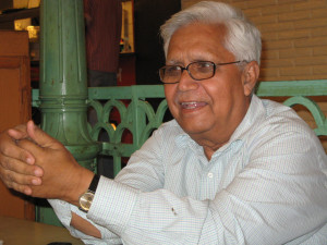
For an MTech Engineer from IIT and a Ph D Structural Engineer, Dr Dinesh Kumar Mishra, Mishra ji, is a colourful personality.
Mishraji, a light moment Photo: kdasgupta2007.wordpress.com
His erudition on rivers and floods in Bihar is tempered by folklore, songs, myths and shayari. A polyglot, Mishraji speaks and writes with eloquence in not only in Hindi and English, but in Bengali, Odiya and Urdu with equal ease. He holds a doctorate from the University of South Gujarat and has been an Ashoka Fellow. Mishraji is an institution in himself when it comes to rivers and floods of North Bihar and has single-handedly contributed to a gradually changing perception of flooding rivers as a catastrophe or “something to be tamed”.
And hence, it gives us great pleasure to share that Mishraji was honored with the Bhagirath Parayas Samman at the India Rivers Week held in New Delhi on the 29th November 2016. India Rivers Week is being organized since November 2014 by a consortium of NGOs including WWF India, INTACH, SANDRP, Toxics Link and PEACE Institute Charitable Trust. More than 100 River experts, planners, researchers, artists, enthusiasts and activists from different parts of the country have been coming together to celebrate India Rivers Week in Delhi in last week of November to discuss, deliberate and exchange their experiences and ideas aimed at the conserving, rejuvenation, restoration of rivers in the country.
Citation of Bhagirtah Prayas Samman states “Dinesh Mishra, an engineer from IIT Kharagpur, has laid the foundation for an extensive knowledge base on floods in rivers.Through his writings, lectures, advocacy and public interactions he has inspired many individuals and organisations to record local knowledge about floods and generate information that creates awareness among communities. All this has become part of a larger social movement… It is an honour to recognize and celebrate Dr Dinesh Mishra’s extraordinary Bhagirath efforts in institutionalizing traditional ways of living with floods.”
Born just prior to independence in a village in Utter Pradesh, Mishraji has dedicated his life in telling us about destruction wrought by infrastructure centric-flood control measures on rivers… especially rivers of the Ganga basin in North Bihar. Since 1984, Mirshraji is engaged in the study of floods, water-logging and irrigation and has slowly nurtured a diverse army which is able to see a lot more in floods than only destruction. He has helped us see the impact of flood control infrastructure like embankments.
Mishraji believes that India’s flood control policy revolves mainly around embankments resulting in severe environmental problems. The maintenance of such structures is in the hands of “indifferent technocracy” which does not take cognizance of the fact that investment in the flood control sector is doing more harm than good. Rising flood prone area of the country is a pointer to that. There are a wide range of aspects that need to be looked into afresh like agriculture, non-farm employment, migration, health, education, and access to civic amenities etc. He finds it intriguing that reciprocal inaccessibility of the flooded areas during the peak season and prolonged water-logging during the peace-time has not attracted the imagination of most of the responsible people. He is trying to learn from the people, their perception of the problem and take it up with those in power while keeping in touch with the people about the probable official intervention. These bridges are rare and much-needed in India. He has raised the issue of floods and water-logging and the links with infrastructure in state, national and international levels.
He has highlighted the futility of embankments as a flood control measures in rivers like Kosi and its tributaries. Through his persistent efforts of over more than three decades, Mishraji has helped change the way river floods are understood and managed. Using an approach which respects the natural cycle of floods, founded on local knowledge, he has robustly challenged the main stream flood control approach. For him, the long-term sustenance of rivers as well as their natural processes is the key, supported by meticulous research into the historical and cultural aspects of rivers.
Mishraji’s narration of how people used to come out in boats to enjoy flooded areas at full moon nights in Bihar is not only poignant, it also reminds us of the paradigm shift that came into our water management when we discarded age-old wisdom and adopted measures which were out of sync for our rivers.
Mishraji’s work is a confluence of solid grass root level contacts, extensive knowledge of local traditions, topography, geography and hydrology, robust field research and unique analysis. His writings including articles, books and films have made a deep impact on current understanding and thinking about floods in rivers and how best to deal with them. Through all this, he has made notable contributions towards developing a new policy dialogue on India’s flood control system, and the impact they have had on livelihood practices.
Mishraji is also the convener of an informal group of flood activists called Barh Mukti Abhiyan, an effective informal group with wide acceptance and vast contacts. He is currently engaged in writing about river Gandak and Ghaghara and thus shall complete the entire landscape of rivers of north Bihar.
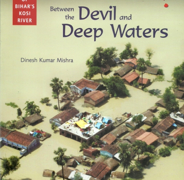
He has over hundreds of Notable among his large number of publications, are “Trapped! Between the Devil and Deep Waters: The Story of Bihar’s Kosi River” and “River Bagmati: Bounties Become a Curse”. His book “Boya Per Babool Ka’ was chosen as one of the best books written over the subject of environment by the Ministry of Forest and Environment, Government of India in 2002. This was later translated into English and published titled, ‘Living with Politics of Floods’ in 2002.
He was a member of the Dams and Development Forum of UNEP and represented Project Affected People there during 2003-07. He was also a member of the Working Group on Flood Control and Water Logging of the Planning Commission of India to review the progress made in eleventh Five Year Plan and make recommendations for the Twelfth.
He has encouraged many organizations to take up the issue of floods and water-logging in their respective river basins, in Bihar and other states as well, and they are carrying on their works. He has encouraged many groups to take up drainage works of small chaurs (land depressions) and resume agriculture on the land that emerges out of water. He provides them with basic technical details and help them executing the work. This has shown very encouraging results as compared to heavily budgeted drainage schemes taken up by the Irrigation Departments.
He has published a book on the River Mahananda (titled Bandini Mahananda in Hindi), a boundary river between Bihar and Bengal, in 1994 followed by a bi-lingual (Hindi and English) book on the Bhutahi Balan (2004) (Bhutahi Nadi aur Takniki Jhar Phoonk / Story of a Ghost River and Engineering Witchcraft) and on the Kamla River (2005) titled Baghawat Par Majboor Mithila Ki Kamala Nadi/ The Kamla-River and People on Collision Course.
His book on the River Kosi titled ‘Dui Paatan Ke Beech Mein – Kosi Nadi Ki Kahaani’ was published in Hindi in 2006. Its updated English version titled “Trapped! Between the Devil and Deep Waters – Story of Bihar’s Kosi River”, co-published by SANDRP, came out in 2008 just before the famous breach of the Kosi embankment at Kusaha in Nepal. Book on Bagmati was published in 2010, titled Bagmati Ki Sadgati. Its English version is also co-published by SANDRP titled “River Bagmati: Bounties Become a Curse” in August 2012. He has now started working on the major river of North Bihar, the Gandak and that will complete detailing the major rivers of north Bihar. This book will touch the Ghaghara and the Burhi Gandak too that flow almost parallel to the Gandak.
Mishraji’s crusade to highlight the wisdom behind age-old methods to “live with the floods”, his fight to expose the utterly destructive impacts of embankments and their role in amplifying flood misery, coupled with his sensitive and scholarly love of folklore and literature make his work accessible and engaging. We need more people like Mishraji who can tell us the stories of our rivers.
We congratulate him for the Bhagirath Prayas Samman and thank him, on behalf of our rivers, for his Bhagirath efforts.
Read the article by Thakkar and Dandekar[1] on sediments with great interest. The basic duty assigned by nature to any river is to build land (nearest word is delta formation), transport the water falling on its catchment to the master drain or the sea and keep the ground water level intact besides saving its fertility. Scriptures define river in many other ways. The basic reason for that was, probably, to discourage tempering with the river. The rivers flow for the good of all the living beings (paropakaray bahanti nadyah), they are cited as an example for continuity. Our ancestors used to bless the younger ones that their name and fame will last till the rule of forests, mountains and rivers are there. There are strict restrictions about polluting rivers and the punishment is also prescribed for doing so. That provides enough food for thought about rivers to us. When we recall our rivers to grace any religious or social ceremony, the emphasis is never forgotten as to what should be our attitude towards rivers. Most of our festivals are held on the bank of the rivers (barring Karmanasa) in Bihar which is called tirthas i.e, the sacred places.
We care too hoots about our rivers now.
An engineer or a trader looks at the rivers about the profits that can be made by the existence of the rivers and they rightly use the word ‘exploitation’ which we all know what it means. As engineers, we all are trained to look into the Benefit Cost ratio and are never taught about the social costs. That is not our job. We tell the politicians where the profit and votes lie. They, in turn, tell all others that they have a team of world class engineers who have advised this or that. The implementers (the contractors) intervene in the mean while. Then there may be financers, promoters, consultants and what not, each with some vested interest or the other. Some of them are for money, some for power, some for name and fame and some for merely impressing others of their proximity with the sources of power.
Each one of them has an insurance that by the time the ill effects of their wrong doing come to the fore, they will not be there in this world. That sets the tone for discussions now.
Let us look at the physical characteristics of river water. The river water contains sediments of all kinds and their shape and size depends on the locations that they are transported to by the river water. The ultimate destination, however, is the sea. I have read considerable literature about sediments and floods and I know that at least since middle of the 19th Century, the British engineers in India have been telling that water is not the problem and it is the sediment that is responsible for flooding. This should be treated first if the floods are to be avoided.
Unfortunately, we are not taught how to deal with sediments and we read about it as a passing reference. Water flows downstream but the sediments remain where the water no more is in a position to push it further down.
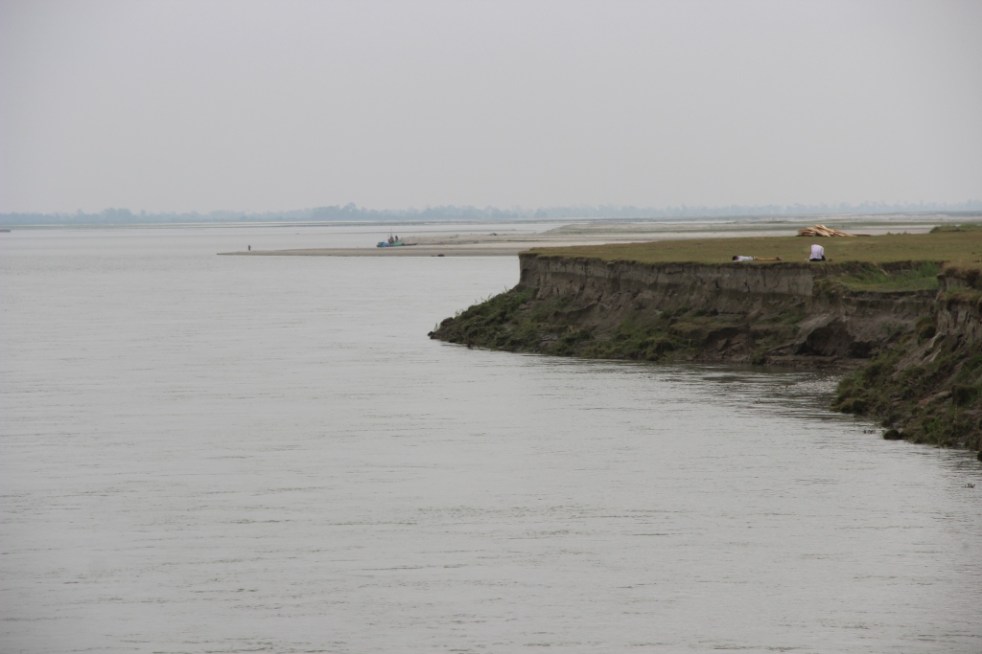
Structurally, if you intercept water by a dam, the sediment will collect in the reservoir area. I had read a report of Central Water Commission a few years ago (I should be having a copy of it somewhere in my collection) wherein they had studied the sedimentation of 64 reservoirs in India but only in two of them their prediction of sedimentation was near to reality. Rest all the dams were in pathetic situation. Trap the river within embankments, the sediment will settle within the embankments and raise the bed level of the river. Kosi is a good example of mishandling of sediments. This river was flowing in 15 different channels some 60 years ago. The engineers embanked just one of these channels and forced all the water and sediments into that channel. The result is that the bed of this channel is higher than the adjoining ground. In lower reaches, the river is aggrading at a rate 12.03 centimeters every year. The engineers and the State is busy raising the embankments without realizing that they are ‘storing disasters for the future generation.’ Construct a ring bundh round a settlement to protect it from the floods of river, the sediment will settle outside the ring to the detriment of the community in future.
Many settlements in Bihar were encircled by such rings in the past. These are all a false security for the people. There is sand casting within the protected area and boats ply there during the rainy season. Some of these rings do not exist anymore because the river has wiped them out. Every step of mishandling sediments leads to a disaster situation which we do not know how to cope with and do away with the sediment.
Look at any silt laden river. It used to spread the sediments free of cost all over the area which is what we call the land building by a river. You disturb a river and this quality is lost.
Then starts the famous debate on forests. The engineers are again confused over the issue and they are not sure whether restoration of the forests can be of any use. Once the ground is saturated due to rains, the role of forests is over, they say. Fortunately such conclusions are not available freely in vernacular. I shudder to think how the masses will react to such wisdom.
I had a chance meeting with the Minister of Water Resources of Bihar before this election and he wanted me to suggest something to combat floods. The discussion boiled down to sediments and the quantity of sediments that passes through Bihar every year.
Irrigation Commission Report of Bihar (1994) talks vaguely about sediments and no inference can be drawn out of it. This may be willful that a reader may not decode the information contained in the report.
Now, if it is understood that sediments are the problem, do we know the amount of it? The answer in ‘No’.
Or, even if it is available, it is not in public domain. We keep on telling that rivers have become shallow but its extent is not known in most cases. I suggested to him that if the government was really serious about the issue, let us take cross section of the river at strategic points that the WRD must have been taking before independence or after the establishment of the Planning Commission and check what is the extent of aggradation of the river bed and what have been the change in the cross section. This will tell us the sediment retained in the river bed and give a hint about its transportation to the sea. It will also tell us that if we pursue the policy of flood control as we are doing at the moment, what will be the fate of the river after say 50 years. He very kindly phoned his principal secretary who, probably, told him that this was possible.
Two questions arise from this discussion, (i) does it require an outsider like me with little access to information that these august bodies dealing with rivers have to tell the minister what should be done to assess the sediments? And (ii) what on earth the responsible engineers of the WRD have been doing all these years? Do they know their job and responsibility well?
Former chief minister of Bihar had announced in May 2009 after the breach at Kusaha on the Kosi (in Aug 2008) was plugged that the embankment is not going to breach for thirty years, at least. Everybody interested in the Kosi issue knows that the breach had occurred because the river was pushed towards eastern embankment of the river by sediment deposition on the west and this was not given the attention it deserved.
I wonder since when the rivers have started taking command from the chief ministers. Even if they do, what will happen in thirty first year?
I am of the opinion that a peon in government is more powerful than a Noble Laureate outside for the peon can get something done through his contacts but the latter can only make a request. It is up to the establishment whether it heeds to his/ her advice or not.
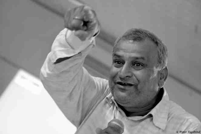
The state of Assam in the northeastern India annually bears the brunt of floods and where embankment construction and repairing seems like permanent affair. Displacement of people living on the banks of rivers due to river bank erosion is another major issue here. The braiding and meandering river Brahmaputra and its tributaries continue to erode the banks rapidly. The Brahmaputra is well known for the rate in which it erodes. Among the places in the path of the river where the brunt of erosion has been felt severely include the following:
– Rohmoria and Dibrugarh town in Dibrugarh district,
– Matmora in Dhakukhana subdivsion of Lakhimpur district,
– Majuli and Nimati Ghat in Jorhat district,
– Lahorighat in Morigaon district and
– Palashbari and Gumi in Kamrup district.
Map of areas taken up for erosion protection in Assam. Source– Assam 2011, A Development Perspective, published by Planning and Development Dept., Govt. of Assam
SANDRP recently traveled to Matmora and Nimati ghat, two of these areas.
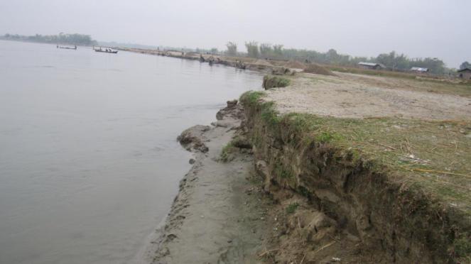
Bearing the Brunt of Erosion Silently Once a large village now only the name Matmora remains. Locals show us towards the middle of the river, to indicate where the village used to be. The rate of erosion is such that the Brahmaputra dyke from Sissikalghar to Tekeliphuta (popularly known as Sissi-Tekeliphuta dyke/embankment) takes the shape of a bow for nearly five kilometers at this place. From 2010, Matmora became very significant in the embankment history of India since country’s first embankment using geo-textile technology was constructed here. This was constructed at the bow shaped eroded line using geotextiles tubes. These tubes were filled up using water and sand from the banks of the river. This five kilometer embankment became a part of the Brahmaputra dyke from Sissikalghar to Tekeliphuta which is 13.9 km long. For the state government and Water Resources Department (WRD) of Assam, Matmora geotube embankment is a story of success of preventing floods and erosion. But what we saw in Matmora presents a different picture.
At Nimati Ghat, the river Brahmaputra is eroding its banks ferociously and people are intimidated by the river. A local person whose village used to be nearly two kilometers from the present bank line, told me, “Nothing can stop Baba Brahmaputra from claiming what he wants”. At Nimati Ghat, the Water Resources Department (WRD) is doing anti erosion work using geo-bags.
Funding for Embankments in Assam The total length of embankments in Assam is 4448 km as stated in a debate in the Legislative Assembly of Assam in 1998. Even though the present length of embankments is not known, it is very clear that the state of Assam continues to construct of newer embankments. In a recent analysis by SANDRP, it was found that the funds continue to increase for construction of embankments in the state. In five years from January 2009 to December 2013, the Advisory Committee in the Union Ministry of Water Resources for consideration of techno-economic viability of Irrigation, Flood Control and Multi-Purpose Project Proposals (TAC in short) had given clearance to projects worth Rs 1762.72 crores. A detailed list of these sanctioned projects can be found in Annexure 1 below.
Matmora Geo-tube embankment after its construction in 2010. Source– Assam 2011, A Development Perspective, published by Planning and Development Dept., Govt. of Assam.
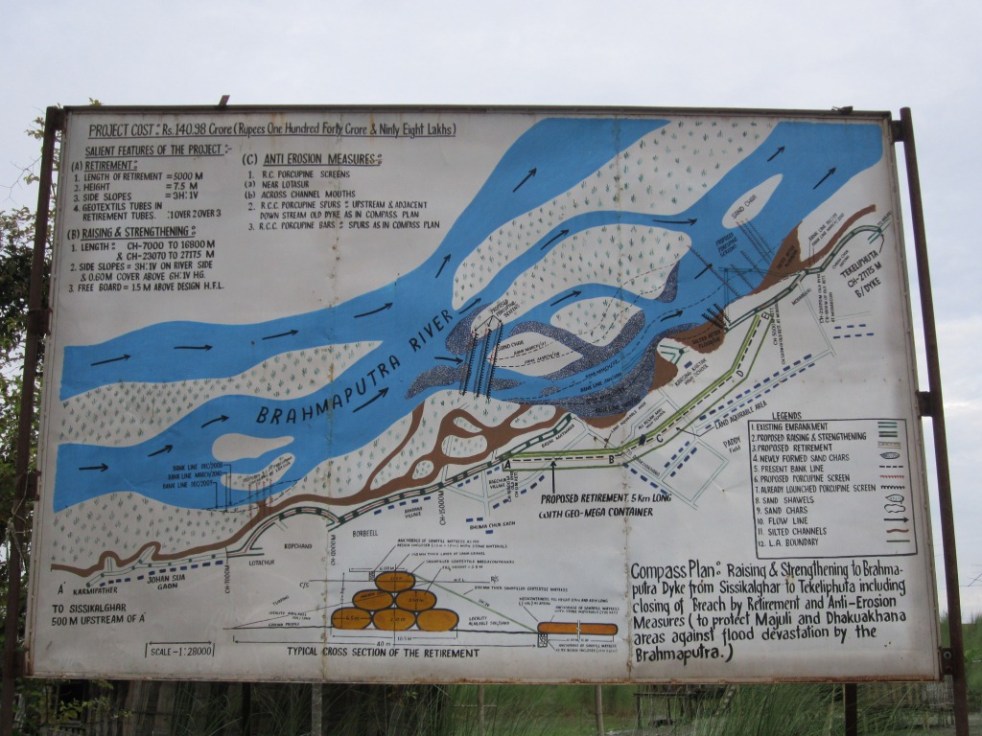
Has Geo-tube been helpful for the people Between January 2009 to December 2013, the Brahmaputra dyke from Sissikalghar to Tekeliphuta, was considered twice by the TAC. The committee in its 95th meeting on 20th January 2009 accepted the project titled “Raising and Strengthening to Brahmaputra dyke from Sissikalghar to Tekeliphuta including closing of breach by retirement and anti-erosion measures (to protect Majuli and Dhakukhana areas against flood devastation by the Brahmaputra, Lakhimpur district, Assam). The estimated cost of this project was Rs 142.42 crore and its project proposal envisaged – (i) Raising and strengthening of embankment for a length of 13.9 km, (ii) Construction of retirement bund with geo-textile tubes of length 5000 m. (iii) Construction of 2700 m long pilot channel.
Geo-tube embankment in Matmora, three years after construction. Photo: SANDRP.
Protection work of the same dyke was considered in the 117th meeting held on 21st March 2013 under the proposal for “Protection of Brahmaputra dyke from Sissikalghar to Tekeliphuta at different reaches from Lotasur to Tekeliphuta from the erosion of river Brahmaputra Assam.” The estimated cost of this project was Rs 155.87 crore. According to the minutes of 117th TAC meeting, the scheme envisaged “restoration of existing embankment in a length of 15300m at upstream and downstream of existing geo-tube dyke, Sand filled mattress in a length of 15604 m at river side slope, geo-tube apron length of 7204 m and Reinforced concrete porcupines as pro-siltation device at different reaches to prevent floods and erosion in Dhakukhana Civil sub-division of Lakhimpur district and Majuli sub-division of Jorhat district.” In the same minutes,while referring to the previous project proposal of 95th meeting the minutes stated that, it “was taken up primarily for closure of breach in the existing embankment including raising of embankment around the breach area only. The proposed works in the present scheme were in the same river reach and these would be required to protect the bank from further erosion and provide flood protection.”
This clearly shows that the geo-tube embankment in Matmora cannot be called a success. Government documents which showed that major part of the Brahmaputra dyke from Sissikalghar to Tekeliphuta remained vulnerable even after the construction of the geo-tube embankment. In fact submitting a proposal for the whole Sissi-Tekeliphuta embankment at first and later saying that the money was spent in constructing a smaller part of the embankment also raise questions. The time gap between the two proposals also raises questions. If the whole money from first proposal was to be spent in constructing only a part of the embankment, why was it not stated clearly in the first proposal? In fact, this was not stated in the first proposal and second proposal reflects that the first project failed to achieve the objectives. If the first proposal was indeed only for part of the embankment, why the proposal to strengthen the larger part of the embankment took 5 years to appear before the committee? The latter proposal also did not mention about the breach which swept away a large part of the Sissi-Tekeliphuta embankment from Jonmichuk to Amgiri Tapit under Sissikalghar and Jorkata village panchayat. According to the local people this breach occurred in the morning hours of 25th June 2012. The photo below shows the breach happened at the Jonmichuk end.
The breached area of 2012. This photo is taken from the new embankment and the lake formed at this spot can also be seen. Photo – SANDRP
Jonminchuk area is nearly 15 km upstream of the geotube embankment in Matmora and part of the Sissi-Tekeliphuta embankment. A new embankment of nearly four kilometer long is being constructed at this place but the remnants of the old embankment still exist. The embankment was breached for nearly 3 kms and the water which entered the fields during that time could no longer go out and a large lake has been formed at this place, see the photo. It was surprising to see people living in the patches of the old embankment.
In the downstream, right from the point where the geo-tube embankment ends, the condition of the Sissi-Tekeliphuta embankment is pathetic. There were cracks in the embankment and water seepage has almost shattered the embankment. The embankment was in need of urgent repairs.
Condition of the Sissi-Tekelphuta embankment at the end point of the geo-tube embankment towards the village side. Photo – SANDRPSissi-Tekelphuta embankment at the same spot mentioned above towards the river side. Photo – SANDRP
Besides, one does not have to travel far to find erosion in the downstream of the geo-tube embankment. After travelling, less than three kilometers from the end point of the geo-tube embankment, rapid erosion was observed at the place where the Matmora and Tekeliphuta ghats join, due to low water level. This joint ghat is more than a kilometer from the toe line of Sissi-Tekeliphuta embankment but seeing the rapidity of the erosion the locals opine that the river would reach the toe of the embankment within this monsoon. It was difficult to believe that the river can erode so fast, until a young man pointed towards a black line in the middle of the river and said that that area which now seemed to be char/sand bar used to be his village three years back. He with his family now live beside the embankment. In this ghat we also witnessed that spurs constructed from the embankment inside the river, mainly to divert the flow of water, have been eroded as well.
The Spur has also been eroded. Photo – SANDRPErosion at Matmora-Tekeliphuta Ghat. Photo – SANDRP
It is also important to note that protection of Majuli from floods was one of the main aims of the geo-tube embankment project, but there were reports of devastating floods affecting Majuli in 2012 & 2013.
After geo-tube comes geo bags With the construction of geo-tube embankments being hailed as a success by the state government, construction of embankments using geo-bags followed. Geo-bags are smaller than geo-tubes and come at a cheaper cost. Embankments on many rivers were constructed using geo-bags which were also used for erosion protection. But effectiveness of the geo-bags as protective measure to flood and erosion, still remains disputed. A news report titled “ADB, river engineers differ on geo-bags” published in Assam Tribune on 9th September 2010 reported about the difference of opinion among the water resource engineers of Assam and powerful lobby of the Asian Development Bank (ADB) for the use of geo-bags to resist Brahmaputra erosion in Palasbari-Gumi and Dibrugarh. Referring to the engineers the news report stated “They have alleged that the ADB provided 23,000 geo-bags for an experiment. They were dumped in the month of September 2009 at a 150-metre-long selected erosion-prone reach at Gumi for testing their efficacy. But, a diving observation made in the month of December 2009, suggested that the bags were not launched uniformly in a single layer as it was claimed. They were found lying in a haphazard manner in staggered heaps with gaps in between and the total distance they covered was only about 8 metres, against the claimed and required 35 metres…..The ADB then carried out another diving observation at Gumi in May last (2010) and found no bag at the site. The State WRD did not get any feedback from the ADB on this issue.”
Work of piling up the geo-bags is going on in Nimati Ghat. Photo – SANDRPStatus of the geo-bags put last year. Photo – SANDRPThe spot where not a single Geo-bag was seen. Photo – SANDRP
Nimati Ghat was the other place which SANDRP visited to find out the effectiveness of geo-bags. The work of piling up the geo-bags for erosion protection was going on when SANDRP visited the area in the second week of April 2014. The bags which were used previously for the same purpose were seen to be mostly lying in water in shattered condition. Locals told us that majority of the bags are now under water. In the eroded bank line, these geo-bags were lying without any order and in a way suggesting how the river has dealt or to say played with these jumbo bags. In this bank line, there was a stretch of nearly five meters where the river has eroded more than the other parts. At this stretch none of the geo-bags were to be seen.
There were also contradictions regarding when the present erosion protection work at Nimati ghat had started. Some of the shopkeepers of the ghat said that the work of putting up geo-bags started in February 2014. But according to the contractor in charge of the work, the work started in November 2013. Construction or repairing of embankment just few months before the advent of monsoons is one of the constant criticisms, leveled against the Water Resources department of the state and in Nimati too we heard the same complaint.
Is Geo-tube really a ‘permanent solution’ to floods? In the present discourse of floods in Assam this has become a very significant question. The local people have been fed with various information about geo-tube and most of which are wrong. The life of embankment constructed using geo-tube is of 100 years, we were told by the locals when we travelled to the upstream areas of Matmora geo-tube. This is absolutely not true. In fact, for Prof Chandan Mahanta of IIT Guwahati the scouring[1] done by the river Brahmaputra will be the major cause of concern for geo-tube embankments in the long run.
The geo-tube embankment has already faced threat of scouring right after its construction in the monsoons of 2011. It was on the morning of 14th July, 2011 when two of the apron tubes at the tail of the embankment, were launched due to increase force of water. The apron tubes were laid at the toe of the geo-tube embankment and with the increased force of water scoured at the bottom by the embankment toe line. WRD engineers flung into action and immediate repairing work was taken up at the site. According to WRD engineers this had happened because the trees which were left outside the embankment had obstructed and increased the force of water and they were immediately cut down. Concrete porcupines were also thrown into the water. Asomiya Pratidin, a regional newspaper reported this on that day but thereafter no report on this could be found. The incident was almost forgotten. When we visited the geo-tube embankment, it was observed that along the toe-line of the embankment a scour line runs for substantial length of the embankment. This clearly shows that scouring by the river has increased in this area. The news report published in Assam Tribune [2]also points out a significant problem associated with geo-bags – “The lobby is mounting pressure for use of geo-bags in the form of bank revetment. Bank revetment is generally not adopted in Brahmaputra because of many reasons. Most important of them is – it produces a permanent deep channel along the existing riverbank.”
On the issue of lobbying behind geo-tube, an interesting perspective was provided by activist-researcher Keshoba Krishna Chatradhara who coordinates ‘Peoples’ Movement for Subansiri and Brahmaputra Valley (PMSBV)’. He opines that the construction of geo-tube embankment in Matmora was an experiment, done to see whether such embankments can withstand the flood and erosion of Brahmaputra. The reason for choosing Matmora first and not other severe erosion affected places like Dibrugarh or Rohmoria, was because even if the embankment fails it won’t be as significant loss for the state compared to those places. Dibrugarh is one of the most important towns of upper Assam with a glorious history whereas Rohmoria became important for the state when Oil India Limited found oil deposits in Khagorijan[3]. Infact several local people and activists also opined that the Sissi-Tekeliphuta embankment which is on the north bank of the river was cut several times, to save the areas in the upstream south bank, mainly the Dibrugarh town. They said that in the past, before the geo-tube embankment came, whenever there was any news of water rising in Dibrugarh, there would soon be a breach in Sissi-tekeliphuta embankment. In fact considering these breaches in the larger Sissi-tekeliphuta embankment, Mr. Chatradhara opined that even if the geo-tube embankment survives the flood, erosion and breaches in future, it might become a small island in midst of a submerged land as there will surely be breaches in the rest of the Sissi-Tekeliphuta embankment.
ADB loan for Geo-textile Embankments in Assam After the construction of the geo-tube embankment at Matmora, the state government is leaving no stone unturned to make it sound like a glorious success. But it is surprising to know that, even before the Matmora embankment was commissioned in December 2010, the state government have filed proposal for two more embankment project where geo-textile would be used for construction and got it cleared. The two subprojects of Assam Integrated Flood River Bank Erosion Risk Management Project (AIFRERM) in Dibrugarh and Palashbari were cleared in the 106th meeting of TAC held on 16th September 2010. It is important to note that for the total AIFRERM project ADB is giving a loan of $56.9 million. The cost of Dibrugarh and Palashbari subprojects are Rs 61.33 crore and Rs 129.49 crore respectively. But these investments have been cleared without even doing a post-construction impact assessment of Matmora geo-textile embankment. The Palashbari subproject also included erosion protection for Gumi area through the use of geo-bags but the Assam Tribune report quoted above already mentioned about how geo-bags scheme has failed in that area.
It is important to note here that, the first geo-tube embankment has been constructed only three years back and it would be premature to give any verdict of success, on the contrary there are many signs of failure. But the state government of Assam and the Assam Water Resources department are claiming it as success without really any credible basis and than have used that self certification to go on building more embankments using geo-textile and in several occasions these plans have failed. They first should have done a detailed impact assessment of the embankment at Matmora before going on building more embankments of the same nature.
It seems the Assam government, ADB and CWC are pushing these projects to deflect attention from the failure of embankments in flood management. Such attempts won’t succeed, but it is possibly a ploy to prolong the use of embankments as a flood management technique.
Parag Jyoti Saikia (meandering1800@gmail.com)
Annexure 1
Flood and Erosion Projects approved for Assam – 2009 to 2013
TAC meeting no & date
Project
Appr. year
River/ Basin
L of Emba. (m)
Original (revised) Cost-CrRs
Benefitting area (Ha)
Decision
95th -20.01.2009
Protection of Sialmari Area from the erosion of Brahmputra
2002
Brahmaputra
NA
14.29 (25.73)
NA
Accepted
Protection of Bhojaikhati, Doligaon and Ulubari area from the erosion
2002
Brahmaputra
NA
14.52 (27.92)
NA
Accepted
Raising & strengthening Brahmputra Dyke from from Sissikalghar to Tekeliphuta including closing of breach by retirement and anti erosion measures
New
Brahmaputra
NA
142.42
NA
Accepted
96th -16.02.2009
Flood protection of Majuli Island from Flood and Erosion Ph-II & III
New
Brahmaputra
NA
115.03
NA
Accepted
Restoration of Dibang & Lohit rivers to their original courses at Dholla Hattiguli
New
Brahmaputra
NA
23.32 (53.11)
NA
Accepted partly & suggested that proposal of coffer dam, pilot channel, etc. to be put up for expert opinion
101st -30.11.2009
Raising and strengthening to Puthimari embankment
New
Brahmaputra
NA
30.23
15000
Accepted
Anti Erosion measures to protect Brahmputra Dyke on left bank
New
Brahmaputra
NA
27.97
5000
Accepted
Protection of Gakhirkhitee & adjoining areas from erosion
New
Brahmaputra
NA
19.06
20,000
Accepted
102 -28.1.’10
Emergent measures for protection of Rohmoria in Dibrugarh District
New
Brahmaputra
NA
59.91
18,000
Accepted
106th -16.09.2010
Raising and strengthening of tributary dyke along both banks of Kopili River
New
Kopilli/ Brahmputra
NA
110.72
NA
Accepted
Assam Integrated Flood River Bank Erosion Risk Management Project
New
Brahmaputra
NA
61.33
NA
Accepted
Assam Integrated Flood River Bank Erosion Risk Management Project
New
Brahmaputra
NA
129.49
NA
Accepted
110th – 20.07.2011
Protection of Majuli from Flood and Erosion Ph II & III
2011
Brahmaputra
115.03
Accepted
Restoration fo rivers Dibang & Lohit to their original courses at Dholla Hatighuli
2011
Brahmaputra
54.43
Accepted
111th – 17.08.2011
Protection of Biswanath Panpur including areas of upstream Silamari and Far downstream Bhumuraguri to Borgaon against erosion
New
Brahmaputra
167.09
Accepted
117 – 21.3.’13
Protecion of Sissi-Tekeliphuta dyke from erosion – Lotasur to Tekeliphuta
New
Brahmaputra
153000 m
155.87
153000 m
Accepted
118th – 30.07.2013
Flood management of Dikrong along with river training works on both banks embankment
New
Dikrong/Brahmaputra
105.96
Accepted
Flood management of Ranganadi along with river training works on both bank embankments
New
Ranganadi/Brahmaputra
361.42
Accepted
[1] Scour can be termed as a specific form of the more general term erosion. In case of geo-tube embankments Scour is the removal of sediment from the bottom of the geo-tubes. Scour, caused by swiftly moving water, can scoop out scour holes, compromising the integrity of a structure.
[3] See ‘Rohmoria’s Challenge: Natural Disasters, Popular Protests and State Apathy’ published in Economic and Political Weekly, Vol XLVI NO 2, Janurary 8, 2011.
This is analysis of the decisions of the Advisory Committee in the Union Ministry of Water Resources for consideration of techno-economic viability of Irrigation, Flood Control and Multi Purpose Project Proposals (TAC in short) for North East India[1] from 95th meeting of January 2009 to 122nd meeting held in December 2013. In our last analysis of TAC minutes we have covered the decision taken for NE states from July 2011 to December 2013 which is available at – https://sandrp.wordpress.com/2014/03/19/lack-of-transparency-and-accountability-remains-the-norm-of-functioning-for-mowrs-advisory-committee/. In this analysis, we have covered the same for an extended period. In these five years TAC has accepted project proposals worth of 5515.46 crores. In calculating the total cost of the projects considered we have considered only the projects whose proposals were given clearance by TAC. In these five years, some of the projects also made two appearances with revised costs. In such cases the higher revised cost has been taken into consideration, e.g. Khuga Multipurpose Project and Dolaithabi Barrage Project, both located in Manipur were accepted by the committee in its 100th meeting (held on 9th October 2009) with revised cost of Rs 381.28 crore and 251.52 crore respectively. In the 115th meeting (held on 24th July 2012) of the TAC, these two projects were considered again where the cost for Khuga Project was Rs. 433.91 cr and for Dolaithabi Project it was Rs. 360.05 Cr. The same is the case for the Thoubal Multipurpose Project which appeared in 101st and 115th meeting of the TAC.
Within these five years, TAC has given financial clearance to 26 flood and erosion control projects and majority of these projects are from Assam. The committee gave the clearance to 6 irrigation projects, 3 barrage projects and 3 multipurpose projects.[2] The committee also gave clearance to a strom water drainage improvement project below Greenfield Airport at Pakyong in Sikkim within this period.
In this period, largest no of considered (25) and approved (20) projects were from Assam. Assam also has the maximum cost of projects among all states (Rs. 2631.99 Cr). Highest number of projects were considered (16) and approved (14) in the year 2009, with total cost of Rs 2321 Crores, which too was highest among all the years.
As found in our previous analysis, in the last five year from 2009 to 2013 TAC has not rejected a single project. Five projects had been deferred but were approved in the subsequent meetings within the same period. In the 108th meeting (held on 4th January 2011), the TAC did not discuss two projects on the Brahmaputra river stating “It was observed that the flood control and anti erosion scheme of Brahmaputra Board are implemented through Central Fund, which do not require investment clearance from the Planning Commission. Therefore, these schemes need not be put up to the Advisory Committee. However, the technical aspect of such project may be looked into by Central Water Commission as per past practice.” But both these projects were reconsidered in the 110th meeting of TAC (held on 20th July 2011) and were cleared by the committee.
So this seems like a rubber stamping committee, clearing everything that comes to it. Reading of the minutes of the meetings also reveals that there are hardly any critical questions asked on merits of the questions for the massive delay and cost escalations that most of the projects suffer. Nor is there an discussion about the performance of the projects.
As we noted earlier, this committee functions in most non transparent, non participatory and unaccountable way. Neither the minutes nor the agenda notes of the meetings are in public domain. Following our letters along with TAC analysis in April 2011, addressed to Planning Commission, Union Ministry of Water Resources, Central Water Commission and members of the National Advisory Council, for the first time, TAC minutes were put up on CWC website (see: http://www.cwc.gov.in/main/webpages/TAC%20minutes.html). However, the last uploaded minutes were for the 115th meeting held in July 2012, after which minutes have stopped being uploaded. Secondly, some of the links are not working and all the files are unnecessarily large PDF files since only scanned pages of the minutes are put up, in place of the PDFs of normal word files, which would be of much smaller size. The TAC also has no independent, non government members, all the members are government officials. As we wrote to MoWR and Planning Commission in April 2011 and again in March 2014, there is urgent need for TAC to have such members so that they provide objective perspective about the projects that come up before TAC.
The importance of functioning of this committee cannot be over emphasised. As we wrote in our letter to MoWR and Planning Commission, TAC “considers dozens of such projects with huge economic, social, environmental and other implications for the country in every one of its meetings. All of these projects are supposed to be public purpose projects, and are taken up using public resources. The Planning Commission accords investment clearance to the projects only after the TAC clearance. This Committee’s decisions are perhaps the ones which impact on India as a whole the most – as they relate to land and water – which are the basic life sustaining and livelihood providing resources for the people.”
It is high time that first effective steps are taken to ensure that the functioning of this committee becomes more transparent, participatory and accountable.
State-wise list of projects cleared by TAC
State
No of Projects Considered
No of projects approved
Total cost of the projects
Arunachal Pradesh
4
4
106.6
Assam
25
20
2631.99
Manipur
10
10
2268.99
Meghalaya
1
1
5.63
Sikkim
1
1
48.55
Tripura
6
6
453.7
Note: No projects from Mizoram and Nagaland have come to TAC in this 5 years period.
Year-wise List of Projects Cleared by TAC
Year
No of Projects Considered
No of projects approved
Total cost of the projects
2009
16
14
2321
2010
5
5
663.67
2011
12
9
497.33
2012
5
5
2208.81
2013
9
9
1439.45
Meeting-wise List Projects Cleared by TAC January 2009 to December 2013
Sl. No
Meeting no
Date of meeting
No of projects considered
No projects approved
No of projects deferred
No of projects rejected
Total cost of the accepted projects, Rs Crore
95th
20.01.2009
4
3
1
0
196.07
96th
16.02.2009
2
2
0
0
168.14
100th
09.10.2009
6
5
1
0
264.73
101st
30.11.2009
4
4
0
0
77.26
102nd
28.01.2010
1
1
0
0
59.91
103rd
11.03.2010
1
1
0
0
302.22
106th
16.09.2010
3
3
0
0
301.54
108th
04.01.2011
2
0
2
0
0
109th
04.03.2011
3
3
0
0
70.13
110th
20.07.2011
5
4
1
0
211.56
111th
17.08.2011
1
1
0
0
167.09
112th
14.09.2011
1
1
0
0
48.55
115th
24.07.2012
5
5
0
0
2208.81
117th
21.03.2013
1
1
0
0
155.87
118th
30.07.2013
2
2
0
0
467.38
119th
29.08.2013
2
2
0
0
601.67
120th
13.09.2013
1
1
0
0
42.96
121st
08.10.2013
2
2
0
0
146.01
122nd
20.12.2013
1
1
0
0
25.56
Total
47
42
5
0
5515.46
95th meeting (20.01.2009): Accepted TOTAL – Rs 196.07 crores (revised costs have been taken into consideration)
SN
Project
Dist/ State
Appr. year
River/ Basin
Original (revised) Cost-CrRs
Decision
1
Protection of Sialmari Area
Morigaon/ AS
2002
B’putra
14.29 (25.73)
Accepted
2
Protection of Bhojaikhati, Doligaon and Ulubari
AS
2002
B’putra
14.52 (27.92)
Accepted
3
Protection of Majuli Island Ph II-III
AS
New
B’putra
116.02
Deferred the proposal with suggestion to prepare the cost at current prices.
4
Raising & strengthening Dyke from from Sissikalghar to Tekeliphuta including closing of breach by retirement and anti erosion measures
AS
New
B’putra
142.42
Accepted
96th meeting (16.02.2009): Accepted Total – Rs 168.14 crores
SN
Project
Dist/ State
Appr. year
River/ Basin
Original (revised) Cost-CrRs
Decision
1
Flood protection of Majuli Island Ph-II & III
AS
New
B’putra
115.03
Accepted
2
Restoration of Dibang & Lohit rivers to their original courses at Dholla Hattiguli
AS
New
B’putra
23.32(53.11)
Accepted partially & suggested that proposal of coffer dam, pilot channel, etc. may be put up to the Standing Committee for expert opinion
100th meeting (09.10.2009): Accepted: TOTAL – Rs 897.53 crores
SN
Project
Dist/ State
Appr. year
River/ Basin
L of Dam
Original (revised) Cost-CrRs
Benefit Irri CCA
Annual Irrigation
Decision
1
Borolia Irrigation Project
AS
1980
Brahmaputra
92 m
6.775 (135.93)
9717
15,000 Ha
Deferred due to non-submission of State Finance Concurrence
2
Khuga Multipurpose (Major- Revised)
Manipur
1980
Khuga/ Imphal
230 m
15 (381.28)
9575
14,755 Ha
Accepted
3
Dolaithabi Barrage Project (Med Revised)
Manipur
1992
Iril/ Manipur
79 m
18.86 (251.52)
5,500
7,545 Ha
4
Gumti Irrigation Project (Revised)
Tripura
1979
Gumti
96 m
5.88 (83.01)
4,486
9,800 ha
Accepted
5
Khowai Irrigation Project (Revised)
Tripura
1980
Khowai
96 m
7.10 (83.01)
4,515
9,320 Ha
Accepted
6
Manu Irrigation Project
Tripura
1981
Manu
82 m
8.18 (98.71)
4,198
7,600 Ha
Accepted
101st meeting (30.11.2009): Accepted TOTAL – Rs 1059.26 crores
SN
Project
State
Appr. year
River/ Basin
L of Dam
Original (revised) Cost-CrRs
Benefit Irri CCA/ flood prot.
Annual Irrigation
Decision
1
Raising & strengthening to Puthimari embankment
Assam
New
B’putra
NA
30.23
15000 Ha
NA
Accepted
2
Anti Erosion measures to protect left B’putra Dyke
Assam
New
B’putra
NA
27.97
5000 Ha
NA
Accepted
3
Protection of Gakhirkhitee and its adjoining areas
Assam
New
B’putra
NA
19.06
20,000 Ha
NA
Accepted
4
Thoubal Multipurpose Project (revised)
Manipur
1980
Thoubal/ Imphal
1074 m
47.25 (982)
21,862 ha
33,449 Ha
Accepted
102nd meeting (28.01.2010): Accepted TOTAL – Rs 59.91 crores
SN
Project
Dist/ State
Appr. year
River/ Basin
Original Cost-CrRs
Benefit-flood protsn
Decision
1
Emergent measures for protection of Rohmoria in Dibrugarh Dist
Assam
New
Brahmaputra
59.91
18,000 Ha
Accepted
103rd meeting (11.03.2010): Accepted: TOTAL Cost of approved projects: Rs 302.22 crores
Project
Dist/ State
Appr. year
River/ Basin
L of Dam
Original (revised) Cost-CrRs
CCA (Ha)
Annual Irrigation (Ha)
Decision
Champamati Irrigation Project
Chirag/AS
1980
Champamati/B’putra
258.5 m
15.32 (309.22)
17,414
24,994
Accepted
106th meeting (16.09.2010): Accepted TOTAL – Rs 301.54 crores
SN
Project
Dist/ State
Appr. year
River/ Basin
Original (revised) Cost-CrRs
Decision
1
Raising & strengthening of tributary dyke on both banks of Kopili River
Assam
New
Kopilli/ B’putra
110.72
Accepted
2
Assam Integrated Flood River Bank Erosion Risk Management Project
Dibrugarh/ Assam
New
Brahmaputra
61.33
Accepted
3
Assam Integrated Flood River Bank Erosion Risk Management Project
Palasbari/ Assam
New
Brahmaputra
129.49
Accepted
108th meeting (04.01.2011): Accepted TOTAL- Rs 0
SN
Project
Dist/ State
Appr. year
River/ Basin
Original (revised) Cost-CrRs
Decision
1
Restoration of Dibang & Lohit rivers to their original courses at Dholla Hattiguli
AS
New
Brahmaputra
23.32(53.11)
The technical aspect pf this type of project may be looked in to by CWC as per past Practices.
2
Protection of Majuli Island from flood & erosion, Ph II-III
AS
New
Brahmaputra
116.02
The technical aspect pf this type of project may be looked in to by CWC as per past Practices.
109th meeting (04.03.2011): Accepted TOTAL – Rs 70.13crores
SN
Project
Dist/ State
Appr. year
River/ Basin
Original (revised) Cost-CrRs
Decision
1
Anti Erosion & Flood Protection work in Dikrong Basin
Arunachal Pradesh
New
Dikrong
23.68
Accepted
2
Anti Erosion & Flood Protection work in Bhareli sub Basin
Arunachal Pradesh
New
Bhareli
16.81
Accepted
3
Anti Erosion & Flood Protection work in Siyom Basin
Anti erosion work along river Gumti from Dlak Samatal Para to Durgapur under Amarpur, Udaipur & Sonamura subdivision
S & West Tripura
Gumti
54.99
2209
Accepted
Anti erosion work along river Khowaii from Netajinagar to Banglahour under Telimura subdivision and from south L. N. Pur to Paharmura bridge under Khowai subvision
[1]While this article only contains the details of the North East India Projects considered in TAC for the five years, we hope to soon provide details of the projects considered by TAC from all over India.
[2] Sicne Khuga Multipurpose, Thoubal Multipurpose and Dolaithabi barrage project, all from Manipur appears twice in this period, they have calculated only for once here.
The Advisory Committee in the Union Ministry of Water Resources (MoWR) for consideration of techno-economic viability of Irrigation, Flood Control and Multi Purpose Project Proposals (TAC in short) is a very important committee. It accords the financial clearance for any irrigation, flood control and multipurpose project. TAC is supposed to discuss the techno-economic viability of projects as per the resolution published in the Union of India Gazette Notification No. 12/5/86-P-II dated Nov 27, 1987. This committee came into being replacing a similar committee that existed earlier in the planning commission. Even now, the guidelines for functioning of the committee are issued by the Planning Commission.
The Gazette notification cited above also said, “The committee may also invite representatives of any other Government organizations, scientific body of experts in the relevant fields to participate in its deliberations.” This seems like a window to appoint credible, independent, non-government persons in the committee, but this window does not seem to have been used. Among the functions of the committee listed in this notification include, “The functions of the Committee will be to examine projects proposed by State Governments, Central Government or other organizations and satisfy itself that the schemes have been prepared after adequate investigations” and “the need of environment conservation and proper rehabilitation of project-affected persons have been taken into account.” However, our perusal of the functioning of the TAC shows that TAC has failed to fulfill both these mandates.
As noted in the Guidelines for Submission, Appraisal and Clearance of Irrigation and Multipurpose Projects, 2010 available on the CWC website (see: http://www.cwc.nic.in/main/webpages/publications.html), “The project proposal, thereafter, is put up to the Advisory Committee for clearance, which is, by and large, like single window clearance.” The importance of such a single window clearance becomes all the more important. The guidelines further note, “On the basis of examination conducted by the Advisory Committee, decision on techno-economic viability of the projects is taken in the meeting of this Committee. The projects found acceptable by the Advisory Committee shall be recommended for investment clearance by the Planning Commission and inclusion in the Five Year Plan/Annual Plan.” This shows how important is the role of the TAC in judging techno-economic viability of projects and also from the point of view of prudent planning.
No Transparency, independent participation or accountability of TAC Considering the above, there is strong case for clearly defined norms for transparency, participation and accountability in (1) functioning of TAC; (2) The screening process of the projects at initial stages that also happen under these guidelines in the Central Water Commission, based on which approval for DPR preparation is given.
In view of the significance of TAC, this is SANDRP’s third analysis of the decisions taken in TAC meetings. The present analysis covers decisions taken for North East India from 110th to 122ndTAC meeting. In the two previous analysis done by SANDRP, TAC meeting decisions taken from 95th meeting to 109th meeting has been covered. Here it is important to note that lack of transparency has been observed right from the agenda and minutes of the TAC meetings. The agenda and minutes of the TAC meetings should be uploaded on CWC website but CWC website has minutes only till the 115th meeting held on 24th July 2012 and the website has been last updated on 31/08/2012.
In this analysis we have covered 13 TAC meetings held from July 2011 to December 2013. In these 13 meeting, 21 projects from 6 northeastern states have been considered. But out of the 13 meetings held, projects from northeast were considered only in 10 meetings. TAC has accepted the proposals for projects with a total cost of rupees 4075.46 crore. Majority of the projects were given clearance at the first time of consideration. Thus, on an average TAC had cleared projects worth of 407.55 crores from the North East in each of these 10 meetings. Number of the projects considered by TAC in each meeting along with their total cost is given below. A state-wise and a project-wise list is also provided.
Total Cost of Projects Cleared by TAC July 2012 to December 2013
Sl No
Meeting no
Date of meeting
No of projects considered from NE
No projects approved
No of projects deferred
No of projects rejected
Total cost of the accepted projects, Rs Crore
1
110th
20-07-11
5
4
1
0
211.56
2
111th
17-08-11
1
1
0
0
167.09
3
112th
14-09-11
1
1
0
0
48.55
4
115th
24-07-12
5
5
0
0
2208.81
5
117th
21-03-13
1
1
0
0
155.87
6
118th
30-07-13
2
2
0
0
467.38
7
119th
29-08-13
2
2
0
0
601.67
8
120th
13-09-13
1
1
0
0
42.96
9
121st
08-10-13
2
2
0
0
146.01
10
122nd
20-12-13
1
1
0
0
25.56
Total
20
4075.46
State-wise list of projects cleared by TAC
Sl. No
State
No of projects approved
Total cost of the approved projects, Rs Crore
1
Arunachal
1
36.47
2
Assam
7
1526.85
3
Manipur
7
2268.99
4
Meghalaya
1
5.63
5
Sikkim
1
48.55
6
Tripura
3
188.97
Note: No projects from Mizoram and Nagaland have come to TAC in this 30 month period.
Some observations regarding TAC meetings
1. Zero Rejections The TAC did not reject a single project. There was only one project which was deferred in the 110th meeting but it was approved in the next meeting. Rest of the new projects were were approved in the very first meeting of their consideration.
2. Lack of information The TAC minutes provide little information about projects. Specially in case of newer projects, detailed discussions should have happened. The minutes of TAC meetings do not give much of an idea about size, location, benefits of a particular project. In the project- wise list provided towards the end of this analysis, we have provided limited information available in the minutes. Some of the noteworthy missing information is listed below:
– In the 115th meeting, 5 projects from Manipur were considered. Out of these five projects, 2 were multipurpose projects and 3 were barrage projects. Surprisingly, there was no information about where these projects are located, on which river, what the size of these projects. None of the minutes mentioned about whom these projects will actually benefit. Only two projects mentioned about increase in annually irrigated land but no more detail was provided.
– In the 118th meeting, construction of embankments on both banks of river Ranganadi for flood management and river training was considered. But the cost of the project was on the higher side compared to the embankment construction work to be done on the river Dikrong, considered in the same meeting. This cost escalation may be due to the difference in the length of the projects. But this cannot be confirmed since minutes do not mention the length of the proposed embankments.
India’s First Geo-tube embankment in Matmora in Dhakuakhana sub-division of Lakhimpur district in Assam. Photo: Parag Jyoti Saikia
But the increased costs may also be due to the use of Geo bag technology for construction of Ranganadi embankments. Use of Geo-bag technology is a costly affair but nothing has been mentioned about the use of this technology in the minutes of 118th meeting. This is stated in the annexure (Annex VI as mentioned in the document) of the meeting. Interestingly this annexure too has been mentioned only as a corrigendum.
3. No Detailed Discussion on Projects Considered This was very evident in the two previous analysis done by SANDRP and situation remains the same this time as well. In case of all the projects, including the ones considered for the first time, there was no detailed information or any detailed discussion. There is no discussion on technical viability of the project. Reading through the minutes gives an impression that approval for any project considered by TAC is fait accompli.There is no discussion about whether the project is a desirable project, if there are other options available, if this is the best option and so on. Under the mandate given to it, TAC is supposed to discuss all these issues. TAC accepted projects proposals with huge cost and time overruns but little enquiry has been made why such escalation happened.
Dhansiri irrigation project This is a glaring example of cost escalation. The project was discussed in the 119th meeting on 29.08.2013 for consideration of cost of Rs 567.05 crores. But, it was surprising to find that original cost of the project in 1975 was Rs 15.83 crores as according to the information available in Assam State Irrigation Department website.[1] The same website states that project started in 1975 and supposed to be completed 35 years later in 2010. In the TAC meeting a new time schedule of March 2015 was stated. The cost of the project has increased by 35.82 times over a period of 40 years but the advisory committee accepts proposal without much scrutiny or enquiry.There was no detailed assessment of the reasons for time and cost over runs (there is no question of delay due to clearances or agitations here) or whether this project which will take 40 years just to complete will be viable or not. On the contrary, the planning commission representatives said, “the benefit cost ratio of the project was 1.2 and any further escalation in cost would result in the project becoming techno-economic unviable.”
The TAC should have done a detailed assessment why the project took so long time to complete. But it seemed to be contended with the rational that the project authorities provided which was that due land acquisition and law and order problem the project has not been completed. But in the meantime minutes of the meeting also showed that that major components of the project are in advanced stages of construction with 93% of barrage work, 99% of the canal works and about 83% of works in the distribution system were reported to have been completed. There has been no detailed assessment in to any of these aspects.
Imphal Barrage project In this project, the cost of the project mentioned in the minutes of the 115th meeting contradicted with the cost provided in the annexure. The cost of Extension, Renovation and Modernization (ERM) of the Imphal barrage project as mentioned in the minutes is Rs 16.80 crores. But a letter from the Under Secretary, Govt. of Manipur to the Chief Engineer of Irrigation and Flood Control Department, Manipur dated 21.07.2012 stated the cost of the project as 23.41 crores. This reflects the lack of serious discussion over projects in TAC. It is also surprising that TAC, being the committee which gives the techno economic clearance to projects, does not have clarity about even the cost of the project.
4. No Discussion over Social, Environmental and Other impacts of the Projects The projects cleared by TAC have serious social, environmental and other impacts but the committee never discussed these impacts. TAC does not at all take into account the impacts a project would have on the environment.
In the 118th meeting (30.07.2013), while considering the proposal for flood management of Dikrong along with river training works on both banks, the minutes stated “Effectiveness of existing embankments of river Dikrong has been deteriorating due to lack of repair, siltation of river bed and consequential change in river behaviour, change in flow pattern due to release of Ranga Nadi hydel project etc.” But this is one of the rare instances when TAC mentioned about the environmental impacts on embankments. But rather than asking for more details on these impacts or to see whether embankment would really be a viable option or not, the TAC accepted the proposal. On the other hand nowhere the committee discussed what impacts an embankment has on river bed, siltation or downstream stretches of a river.
Dikrong Power Station at Hoz where water from Ranganadi HEP is released in Dikrong/Pare. Photo: Parag Jyoti SaikiaRiver Dikrong at Dikronghat in Lakhimpur district of Assam where it erodes rapidly. The impacts of change is water flow is clearly visible. Due to release of water in upstream water at night covers the lower portion of the bank. This photo was taken around 8am in the morning when the water receded. The lower bank portion was wet in the morning. According to the local the water further recedes by the evening and again increases at night. Photo: Parag Jyoti Saikia
It is also important to note here TAC also does not take into consideration impacts of the hydropower projects on the embankments in the downstream of the river. In the above mentioned case, the increased costs of Dikrong embankment should have been charged on the Ranga Nadi HEP, but there is no discussion on this. The Pare hydropower project (110 MW) in Papumpare district of Arunachal Pradesh is currently under construction on Dikong / PareRiver. Moreover there are at least 10 hydropower projects at various stages in the combined Ranganadi-Dikrong basin in Arunachal Pradesh, including one operating, three TOR approvals given and five additional MoA signed (in addition to a proposed project). There is no provision to assess the impacts of these projects on the embankments downstream of DikrongRiver in Assam. In fact there is no provision for any impact assessment study for embankments even though studies show the disastrous impacts of embankments on environment, floods and on the lives of the people living close to the river.
5. Clearing Same Embankment Projects over Years In terms of embankments, it is observed that the TAC had cleared same projects over the years. Not emphasizing on the environmental impacts of embankment projects is one of the major reasons for this. In the 117th TAC meeting held on 21.03.2013 the proposal for “Protection of Brahmaputra dyke from Sissikalghar to Tekeliphuta at different reaches from Lotasur to Tekeliphuta from the erosion of river Brahmaputra Assam” was considered. The estimated cost of the project was Rs 155.87 crore. But on the same embankment, a project titled “Raising and Strengthening to Brahmaputra dyke from Sissikalghar to Tekeliphuta including closing of breach by retirement and anti-erosion measures (to protect Majuli and Dhakukhana areas against flood devastation by the Brahmaputra, Lakhimpur district, Assam) was accepted in the 95th TAC meeting held on 20.01.2009. The estimated cost of the earlier project was 142.42 crore.
A Hoarding on the way to Geo-tube embankment in Matmora, describing the project. Photo: Parag Jyoti Saikia
The minutes of the 117th meeting, about the previous scheme said that it “was taken up primarily for closure of breach in the then existing embankment including raising of embankment around the breach area only.” But the minutes of the 95th TAC meeting had said something totally different about the project. The minutes stated that project proposal envisaged – (i) Raising and strengthening of embankment for a length of 13.9 km, (ii) Construction of retirement bund with geo-textile tubes of length 5000 m. This shows how the discussion on the Brahmaputra dyke Sissikalghar to Tekeliphuta is 117th meeting is completely misleading. TAC does on even take into account its previous meeting discussions before clearing a project. This possibly gives a hint of a scam.
The Brahmaputra dyke from Sissikalghar to Tekeliphuta has a long history of facing severe erosions. The first geo-tube embankment was constructed on this dyke in Dec 2010. Crores have been spent for the protection of this embankment. But even after that the Dhakukhana sub-division always remained in the headlines during the flood season in Assam. There is need for area specific detailed study assessing the impact on and of the embankment, but little has been done in this regard. Besides, the Bogibeel Bridge, the fourth one on the BrahmaputraRiver, is coming up in the upstream of this embankment. Construction of this bridge would make this dyke even more prone to erosion since the length of this bridge will be 4.94 km, shrinking the wide river to great extent. In a personal visit to the area, one of the government officials informed that as a result of this “funneling action”, the force of water will increase and it will directly hit the embankment leading to more erosion. But TAC has never dealt with these issues in its meetings but cleared all the proposals that it considered. Short History Brahmaputra Dyke from Sissikalghae to Tekeliphuta[2]
6. There is no independent, critical voice in the meetings. The agenda, proceedings, or decisions of the meetings are not even in public domain.
7. There is no mechanism to hold the TAC accountable for any wrong decisions taken.
8. The TAC is clearly not fulfilling the mandate given to it in the guidelines for TAC meetings. The guidelines themselves need revision from several points.
9. There is no attempt to assess the justifiability of the kinds of projects that are being accepted and if they are indeed delivering the promised benefits.
Anti erosion work along river Gumti from Dlak Samatal Para to Durgapur under Amarpur, Udaipur & Sonamura subdivision
S & West Tripura
Gumti
54.99
2209
Accepted
2
Anti erosion work along river Khowaii from Netajinagar to Banglahour under Telimura subdivision and from south L. N. Pur to Paharmura bridge under Khowai subvision
Today (on Dec 17, 2013) is the 8th day of indefinite fast by flood activist Shashi Shekhar in Sitamarhi (Bihar) with a demand to stop work on the unwanted and unjustified embankment along the Jheem river (part of Adhwara group of rivers in North Bihar) and for bringing Lakhandehi river back to its path where it was flowing less than a decade back. Several others have joined the fast since it started on Dec 10, 2013.
Activist Shashi Shekhar Speaking at a workshop in Patna
The demand is to prevent the shifting of river Lakshmana Ganga (Lakhandehi) toward east and to divert the river towards the west, so that the 147 km stretch of the original course resumes to get the river water, thereby helping hundreds and thousands of farmers, who are presently facing water scarcity. This can be done by desilting of the Lakhandehi river. The demand is also to stop work on the embankment along the Jheem River.
We are copying below the statement below compiled by Megh Pyne Abhiyaan, Bihar, from the statements and reports provided by Mr Shashi Shekhar. It explains the background of the situation.
Bihar government that has taken the decision of building the embankment without any consultation with the local people and even without any impact assessment and seems to be driven by contractor interests and have not yet bothered to respond. The state water resources ministry says that only the Chief Minister Nitish Kumar can take a decision on this and we see not effort from that quarter. With every passing day the health of Mr. Shekhar is deteriorating and the state government will be held responsible for any eventuality in this regard.
All this also highlights a serious anomaly in the Government of India’s EIA notification of Sept 2006 that excludes embankments and other such flood related structures from the need for environment clearances, environment impact assessments and also any public consultation process. This is clearly wrong since embankments have huge social and environmental impacts. This needs to urgently change, but the MoEF has not done that in spite of numerous letters to the ministry since 2006.
Local media is reporting on this on daily basis; the national media is yet to carry this except an isolated report or two[1]. We hope national media carries this important news.
SANDRP
PS: On Dec 19, 2013, Eklavya Prasad conveyed: Flood-activist Shashi Shekhar’s indefinite fast (against the construction of embankments along Adhwara Samuh and demanding de-silting of River Lakshmana Ganga (also known as Lakhandehi) was called off last evening. The negotiations between the district administration/state and Shashiji went off well and ALL his demands were have been accepted. According to Shashiji his indefinite fast has helped to take issues to a logical conclusion!
3. Chicu from IWP wrote this piece in March 2014, which says the demand of bringing the Lakhandei river back to its course is not feasible and due to the priorities of the state government, the construction of embankments is likely to continue.
4. July 28, 2014: A petition by Shashi Shekhar against “the present project for raising the embankment along river Jhim and Jamura (Adhwara Group) from Sonbarsa Bazar to Sonbarsa Village” was rejected by Patna High Court, see full order: https://indiankanoon.org/doc/154770140/. It said in the end: “Counsel for the petitioners then submitted that in the name of the project the executants of the project are coming to the raiyati land in the adjoining area and are forcibly cutting the soil from the raiyati land. If that is so, the raiyat concerned, from whose land soil is forcibly taken out by the executants of the project, is at liberty to lodge First Information Report against such illegal soil cutting from the raiyati land.”
5. March 28, 2017: A petition by Brahmaputra Infrastructures, one of the contractor for the project, in Patna High Court. The order is available here: https://indiankanoon.org/doc/50437728/.
Statement
Sangharsh Yatra – A incessant protest for service, development and justice
Highlight On December 10, Shashi Shekhar, a well-known flood activist from Sitamarhi district of north Bihar started an indefinite fast on the banks of River Lakshmana Ganga (also known as Lakhandehi), as part of Sangharsh Yatra, protesting against the construction of embankments along Adhwara Samuh rivers.
Background River Lakshmana Ganga (Lakhandehi) previously flowed into India near pillar number 32 at Dularpur village in the Sonbarsa block of Sitamarhi district after crossing Simraha in Nepal. The distance between these two villages across the border is approximately 1.5 kilometers (km). However, presently the river has shifted almost 1-1.5 km east from its original location (i.e pillar number 32). The reason for this shift is being attributed to the siltation that has occurred, 8 km north of the Indo-Nepal border around Laxmipur village, which is located in Nepal. Because of this shift, the river on the Indian side has now started flowing near pillar number 35 at Choti-Bharsar village.
The shift in the river’s course towards east has resulted in its draining into river Jamuda, which is a part of the Adhwara-Samuh. Additional water of river Lakshmana Ganga (Lakhandehi) in river Jamuda has started causing floods thereby affecting Sitamarhi, Darbhanga, and a small part of Madhubani districts. People fear that the consistent shifting and flooding of Lakhandehi towards the east will lead to the flooding of the river Jheem, which is also a part of the Adhwara-samuh. They believe that flooding of Jheem will create havoc in the region as Sonbarsa block will get inundated. The shifting of the Lakshmana Ganga (Lakhandehi) from the west to east has dried up the original 147 km stretch of the river (in India), causing problems for the local farmers. Sustenance of productive agriculture along the old course of Lakshmana Ganga (Lakhandehi) is posing as a huge challenge.
The protest According to Shekhar, since 2002 he has been fighting against the mindless construction of embankments by writing letters to various government authorities and holding discussions with the concerned officials. However, there has been no positive response from the Bihar government, forcing him to take the extreme step of indefinite fast to protect the rivers from further destruction.
According to Shekhar this indefinite fast is to attract state government’s attention to prevent the shifting of river Lakshmana Ganga (Lakhandehi) toward east and to divert the river towards the west, so that the 147 km stretch of the original course resumes to get the river water, thereby helping hundreds and thousands of farmers, who are presently facing the wrath of river water scarcity. On the other hand, Shekhar is also trying to address the problems of farmers around and along the river Jamuda of excessive floods, being caused by the the draining of the river Lakshmana Ganga’s (Lakhandehi) water into river Jamuda. The other reason for Shekhar to resort to an indefinite fast is to highlight the skewed flood management strategy adopted by the state government. According to him, the shifting of Lakhandehi is causing excessive floods in Adhwara-Samuh. However, the state instead of constructing ‘thokars’ (boulder structures) to divert Lakhandehi from east to west, is investing in construction of embankments along the rivers of Adhwara Samuh.
The sheer diversion of the river Lakhandehi will substantially reduce the incidences of floods in Adhwara Samuh. This simple logic/solution is being ignored by the state government under the pretext of Lakhnadehi being a trans-boundary river, as if no structural intervention has ever taken place in any trans-boundary rivers in north Bihar. According to him the state government is using the scenario to basically push for the mindless construction of embankments along the Adhwara Samuh rivers. The embankments that are being constructed are approximately 20-25 feet tall and the distance between two embankments is 80-500 feet. Shekhar is unable to fathom the technical reasons for the constructions of these embankments along the rivers that stay dry for almost four months a year and are only 20-40 feet wide.
Shekhar is raising strong objections to the manner in which embankments are being constructed and repaired on Adhwara Samuh rivers by contractors – M/S Brahamputra Construction and M/S Avantika Dhara Reddy and Brothers. With support of police officials and some bureaucrats, these contractors have forcibly taken lands from the farmers by threatening them to sign on false papers. Shekhar claims that no compensation has been given by the government for the land that is inside and outside (immediate vicinity) of the embankment. The land acquired for the construction of the embankment is what has been compensated, though farmers have been offered a pittance as compensation against their land.
According to Shekhar, all statutory compliances have been flouted. BIS states that excavation of earth should take place at the distance of 80 feet from the embankment. He mentions that the BIS also states that apart from leaving a distance of 80 feet the excavation should happen parallel to the embankment in small stretches of 20 feet length and 1-3 feet depth. The reason for the excavation to happen in small stretches is to prevent formation of drainage along the embankment. In reality, the excavation is taking place haphazardly. The contractors/petty contractors are extracting earth within 2-5 feet from both sides of the embankment; with an approximate depth of 10 feet and in the process the standing crops have been destroyed for which no compensation has been given to farmers. Shekhar states that the present practice is turning out to be a big scam which he calls as ‘Mitti Ghotatla’ – Soil/Clay scam. Felling of trees along Lakhandehi, Adhwara Samuh and Bhagmati rivers have been carried out for construction purposes. All this is having an adverse environmental/ecological impact on the rivers and human population. Shekhar is unable to fathom why the state government is not keen on diverting river Lakshmana Ganga’s (Lakhandehi) water which will cost far less than constructing embankment on Adhwara Samuh.
Through his indefinite fast, Shekhar is demanding rightful compensation for the affected farmers; a high level enquiry into the illegal manner in which embankments have been constructed along Adhwara Samuh rivers by deceiving local villagers; withdrawal of false police case against satyagrahis fighting to protect the river; an investigation of links between both the contractors — M/S Brahamputra Construction and M/S Avantika Dhara Reddy and Brothers — and Naxalite groups; and an enquiry into the soil/clay scam worth Rs 200 crore in Bagmati and Adhwara Samuh rivers.
Shashi Shekharji has been able to generate support from opposition leaders within the state, farmers and spiritual people from the region but is looking forward to additional support from all quarters to create pressure on the state government to explore alternatives….
(Compiled by – Nidhi Jamwal, Bhavya Durgesh Nandini and Eklavya Prasad)
Statement in Hindi
Sources
Þ Personal communication Shashi Shekhar, Dec 2013;
Pic: 1Erosion in Rohmoria in the Upstream of Dibrugarh. Source: The Assam Tribune
The National Disaster Management Authority (NDMA) has recently published a report named “Study of Brahmaputra River Erosion and Its Control”. NDMA had commissioned this study to the Department of Water Resources Development and Management of IIT Roorkee. NDMA is an apex body constituted under the Disaster Management Act, 2005 to prepare the country to face natural and human-made disasters. NDMA is headed by the Prime Minster of India. Under the natural disasters category it includes earthquake, flood, tsunami, land slide and avalanches while nuclear, chemical or biological disasters have been categorized as human-made disasters. This report provides a lot of information and data on the Brahmaputra and its tributaries. The information about erosion is also very much detailed and descriptive. The report can be found at http://ndma.gov.in/ndma/latestdisasterupdates/NDMA%20Final%20Report%20Brahmaputra%20River.pdf
Pic: 2 Recent News Reports of Erosion in Subansiri River, One of the Largest Tributaries of Brahmaputra on the North Bank. Source: Dainik Janambhumi
Pic: 3 Houses on the side of the Old Embankment in Matmora. Source: Parag Jyoti Saikia
This reports deals with a very serious issue of erosion in the Brahmaputra river basin in Assam. Erosion should not be confused with floods even though both are annual phenomena in the Brahmaputra river basin. Erosion can be seen to have a more severe impact than floods because erosion leads to permanent loss of land and property. During floods land and houses are submerged for a period of time. But erosion displaces people from their land and property for good. Erosion inflicts severe damage to agriculture, economy and cultural relations of people. Erosion compels people to migrate to different places. Villages get eroded one after another and people living in those villages have to move to another location with their belongings. But this may not be possible and affordable for all those who lost their land in erosion. So for many of them, living on the side of embankments in very poor living conditions remains as the only option. Erosion also leads to migration of rural youths to urban areas in search of jobs. In the last few decades erosion has posed as a greater threat to the people of Assam than floods. The severity of erosion can be seen from the Table 7 of the report in which Satellite Based Estimation and Comparison of Area Eroded In Brahmaputra during the Period 1990 to 2007-08 and 1997 to 2007-08 have been presented.
Map of the Study Area from the Report
The study divides the river length into twelve segments from Dhubri to Dibrugarh and that is why there are 12 reaches mentioned in the table. It is clear from this table that the while the erosion prone length of the river is 10% higher along the South Bank of Brahmaputra compared to the same along North Bank. Areas facing erosion is 123% higher in South bank during the last decade (1998-2008) of the study period. The highest erosion area/per km of erosion prone bank is upstream of Dibrugarh, where the river enters the plains from the hills.
Areawise division into 12 reaches in the river
North Bank
South Bank
Total Erosion Length
(in km)
1990 to 2007 – 08 (in sq. km)
1997 to 2007-08 (in sq. km)
Total Erosion Length
(in km)
1990 to 2007 – 08 (in sq. km)
1997 to 2007-08 (in sq. km)
1. Dhubri
40.19
124.461
94.129
7.05
194.983
10.791
2. Goalpara
39.5
79.046
40.902
4.85
17.816
5.052
3. Palasbari
54.87
48.668
42.914
14.02
23.006
15.859
4. Guwahati
21.02
7.92
1.654
24.38
5.385
12.079
5. Morigaon – Mangaldai
6
35.606
2.138
47.91
96.979
103.7
6. Morigaon – Dihing
24.86
29.057
7.275
47.8
10.795
56.72
7. Tezpur
8.58
38.758
4.733
52.95
16.628
44.774
8. Tezpur-Gohpur
8.85
31.187
5.794
44.16
26.098
71.227
9. Majuli-Bessamora
24.69
25.562
12.327
47.17
32.788
28.998
10. Majuli Sibsagar
16.93
60.657
16.878
54.95
44.018
42.118
11. Dibrugarh
37.86
37.506
43.529
43.89
46.595
6.066
12. U/s Dibrugarh
70.5
20.376
55.454
57.54
399.529
333.416
Total
353.85
538.805
327.726
389.13
914.62
730.8
The Study Report:There have been a lot of studies done on the river, to find a solution to the issue. But what comes as a surprise is the attempt to shy away with some of the crucial issues of the riverine eco-system in the northeast. But before going into crucial issues, a brief note about the report is provided.
The March 2012 study is divided into two phases. The first phase is named as ‘Sattelite Data Based Assessment of Stream Bank Erosion of Main Stem Brahmaputra and Its Major Tributaries’. In the second phase processing and analysis of the hydrological data of the Brahmaputra and its tributaries has been done.
In the first phase of the study information and data of 18 years (1990 to 2008) has been put together. The study pertains to a reach of 620 km on the main stem of Brahmaputra River, i.e., its entire course in Assam from upstream of Dibrugarh up to the town Dhubri near Bangladesh border. 23 major tributaries (13 northern and 10 southern) within India have also been considered. The data for this whole area was collected using an integrated mechanism of Remote Sensing and Geographical Information System.
In the second phase of the study a new method of analysis called Artificial Neural Networks (ANNs) has been used. The data processed through this analysis has been used for modeling the rainfall-runoff process and runoff-sediment process for the study area.
The report identifies inherent ‘sediment overloading’ of the river fluvial system as the main cause for river bank erosion vis-à-vis channel instability in Brahmaputra. The report recommends by proposing river training works for two pilot areas on Brahmaputra River. The first site is in Bhuragaon of Morigaon district and second one is near the Guwahati airport.
Critical issues:
The team of investigators for this study was led by Prof Nayan Sharma of the Department of Water Resources Development and Management at IIT Roorkee. This is a very descriptive report from the point of information and data about the river Brahmaputra and its tributaries. But even then there are several things that the report does not mention at all.
The report mentioned that inherent ‘sediment overloading’ as the prime cause for erosion in the river Brahmaputra. But another study named “River Bank Erosion and Restoration in the Brahmaputra River in India” has identified several other factors responsible for bank erosion.[1] That study states “The salient hydraulic and bank material factors responsible for bank erosion of the Brahmaputra system are i) rate of rise and fall of river water level, ii) number and position of major channel active during flood stage, iii) angle at which the thalweg approaches the bank line, iv) amount of scour and deposition that occurs during flood, v) variability of cohesive soil in bank material composition, vi) formation and movement of large bed forms, vii) intensity of bank slumping, and viii) progression of abandoned river courses to present-day channel.”
Identifying only ‘sediment overloading’ as the main reason for a dynamic river system like Brahmaputra seems an over simplification that overlooks the critical issues.
Pic: 4 A view of the Balijan Tea Estate Eroded by the Brahmaputra in Rohmoria in Dibrugarh district of Assam. Source: The Hindu
Even though the report identifies sediment overload as the prime cause of erosion, it has provided insufficient analysis as to why the sediment load is actually increasing in Brahmaputra. The report rightly states “Accelerated erosion has occurred in this region due to intensive deforestation, large – scale road construction, mining and cultivation on steep slopes.”
Pro Hydro Bias:Here the report completely ignores case of hydropower development in Arunachal Pradesh and its impact on Brahmaputra and its tributaries. The report nowhere mentions about the proposals for 168 hydroelectric dams in Arunachal Pradesh and its impact in the rivers in Assam. In the recent times, the state has witnessed mass protest against hydropower development in Arunachal Pradesh. In fact the report shows a pro-hydro bias when it laments that “less than 5% of the existing hydropower potential” have been put to use so far. At a time when people are demanding for cumulative impact assessment of dams on the rivers of Assam, reports like this attempt to create confusion among people. It is to be noted that when Assam was witnessing the mass protest against big dams, it was Dr. Nayan Sharma who appeared in the electronic media advocating for big dams.
Pic: 5 Erosion protection work at Nimatighat on the Brahmaputra in Jorhat District on May 5th 2013. Source: http://www.prokerala.com[2]
Bias for Structural Intervention: This report advocates for structural intervention for flood protection and reiterates the need for more embankments. Lots of analysis has been done on the ill effects and poor performance of embankments. Embankments essentially transfer the problems to the downstream. There are ample examples of how structural interventions made for erosion protection have failed. We can take the example of Rohmoria, located in the upstream of Dibrugarh town in this regard. There were a series of structural interventions made to control erosion but it failed.[3]
The embankments proposed in this report for the two pilot-study areas are proposed to be constructed using geo synthetic bags. The geo-synthetic bags will be put inside polymer rope gabions[4] and installed in the critical toe of the bank line. The efficacy of controlling erosion through geo-tube embankments still not established, but even then geo-tubes have become the buzz-word for flood protection in Assam. The Asian Development Bank has offered a loan of $12 million for erosion protection through construction of geo-tube embankments. But Assam government engineers working on Brahmaputra and its tributaries are critical of ADB’s programme of erosion control through geo-tube. In a report published in regional news paper on March 2010, it was stated that revetments like geo-bags cannot be successful in Brahmaputra because it creates a permanent deep channel along the existing river bank.[5] The report also stated that geo-synthetic bags which were installed for bank protection in Palashbari-Gumi area were washed away by Brahmaputra. This area is in the downstream of Saraighat Bridge and close to Guwahati airport area where one of the pilot projects has been proposed.
Impact of Structural Interventions Ignored:The report provides structural solution for erosion control but ignores erosions which were a result of structural interventions in the river. Studies on Brahmaputra basin have shown that during and after the construction of bridges in the river Brahmputra erosion and floods have increased in the downstream areas.[6] In the case of Saraighat Bridge, unprecedented flood and erosion was witnessed in Palasbari and Gumi area. Morigaona and Nagaon districts suffered the same after the construction of Koliabhomora Bridge. Construction of Naranarayan Setu, led to flood and erosion in Dakshin Salmara, Pancharatna and Mancachar.
Similar fears have been expressed for the fourth bridge on Brahmaputra which is under construction between Bogibeel of Dibrugarh district and Kareng Chapori of Dhemaji district. The river is nearly 9 km wide at this point. But for the construction of this bridge, the river had been shrunk to almost 5 km through the boulder spurs. This is posing a great threat of flood and erosion for the downstream areas which include famous river island Majuli and Matmora, where India’s first geo-tube embankment was constructed. Engineers who are involved in the construction of the dykes of the fourth bridge had been reported saying that Matmora area would come under severe threat due to the increased river pressure in the area. The report completely ignores all these facts and shows ‘sediment overloading’ as the cause of erosion.
Besides, the study gives a feeling that erosion in the river Brahmaputra operates in ceteris paribus[7]. The report made no mention about climate change and how it is going to impact a river like Brahmaputra which is flowing right from the Himalayan mountain range. At a time when impacts of climate change are taken into account for every possible environment related matters, ignoring this is another major lacuna of this report.
These critical lacunas put a question mark over the usefulness of the otherwise informative study. Credibility of IIT Roorkee reports have been questioned in the past too.[8] NDMA may keep this in mind and focus on more basic issues. For starters as monsoon sets in and rounds of floods start along Brahmaputra, NDMA’s flood forecasting links have stopped functioning for five days as we publish this in the 1st week of June 2013.
Parag Jyoti Saikia
South Asia Network on Dams, Rivers & People (www.sandrp.in)
[4] Gabions are sausages made of Polymer ropes that are appropriately woven by a special process to fabricate the Gabions in various sizes. Gabions are generally available in a prefabricated collapsible form. Images of polymer rope gabions can be found here – http://www.garwareropes.com/polymer_rope_pro_g.htm
[6] Mahanta, C; Mahanta, A., ‘Bridge over The Brahmaputra’ Economic and Political Weekly, pp 579-581, 2006
[7] Ceteris paribus is a Latin phrase which can be literally translated as “holding other things constant” and usually rendered in English as “all other things being equal”