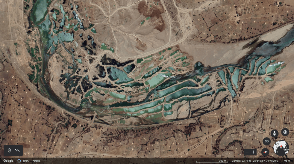
(Feature Image: Screen shot of undated google earth image showing multiple vertical, horizontal bunds created by deep, mechanized riverbed mining across Betwa near Bheri Dariya in Sarila tehsil of Hamirpur district.)
The comparison of Sentinel satellite images dated February 20, 2023 with images of September-October 2022 reveal large scale riverbed mining operations along Betwa river at multiple sites in Jhansi, Jaluan and Hamirpur districts. The details of some of the sites is given in table below followed by the satellite imageries and time lapse animation of few sites.
| SN | Site, Tehsil/ District | Latitude/ Longitude | Affected riverbed area | Remarks |
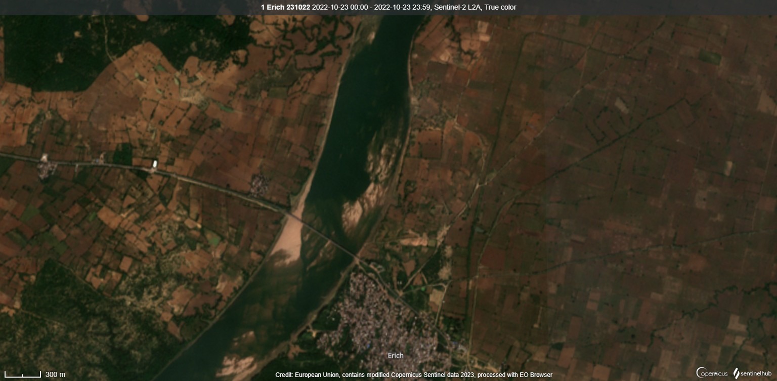
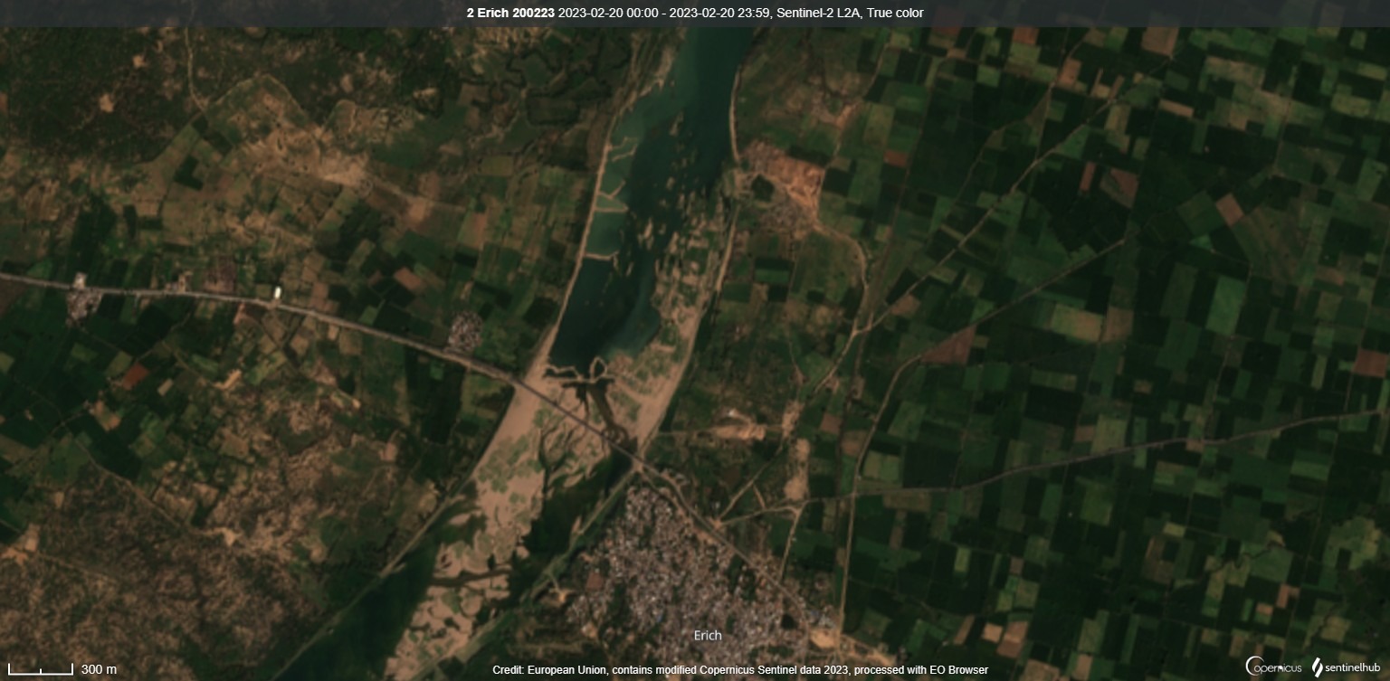
| 1 | Erich & Bhaura Rath/ Jhansi | 25.798853 79.083304 | ~0.85 sqkm ~0.64 sqkm | Flow blocked, Pondages created in middle portion, About 4 inward bunds on right bank, Increase in siltation in river |
| 2 | Jhingharia, Garautha/ Jhansi | 25.800663 79.248786 | ~0.13sqkm | Longitudinal bunds created in riverbed, Scars of deep, excessive mining visible, Pondage impact & siltation load |
| 3 | Hilgna, Orai/ Jalaun | 25.77328 79.33349 | ~0.32 sqkm | In-stream mining on right bank, ~1km long liner bund in riverbed built in two parts Pondage & obstruction of river flows, Increased siltation load visible |
| 4 | Makrechha, Dakore/ Jalaun | 25.80454 79.42238 | ~1.52 sqkm | Excessive, in-stream, mechanized mining on both river banks, Horizontal, verticals bunds created in active riverbed, Width of river flowing course reduced, Over dozens deep ponds visible, Siltation load affecting river water quality, |
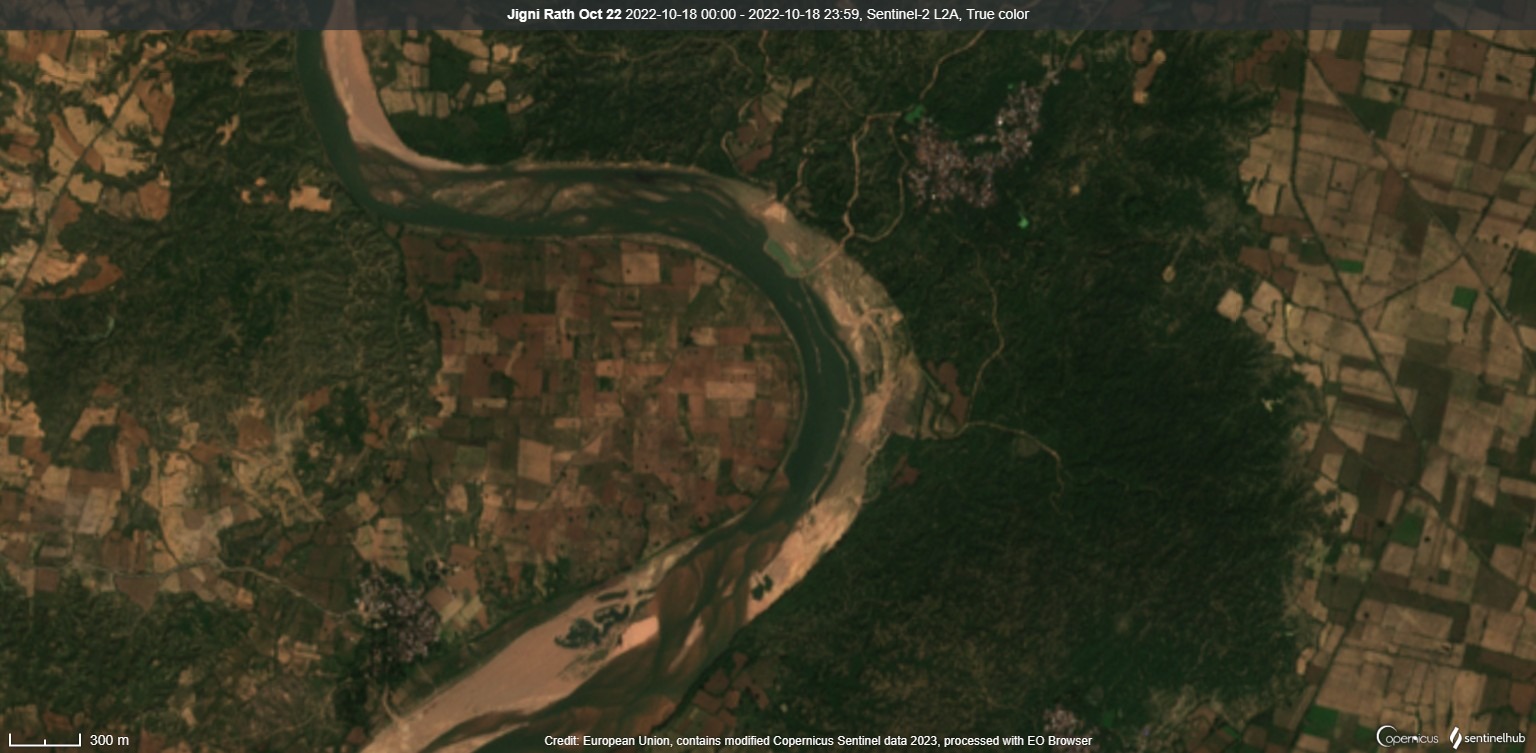
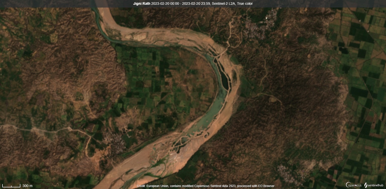
| 5 | Gadhar & Jigini, Rath/ Jhansi | 25.70992 79.37225 25.72707 39.39009 | ~0.26 sqkm ~0.85 sqkm | Excessive mining in Dhasan river at 2 sites, River width & flows hugely reduced, blocked ~2 km long longitudinal bund built in riverbed, Deep ponds created in riverbed, Water quality affected by suspended silts |
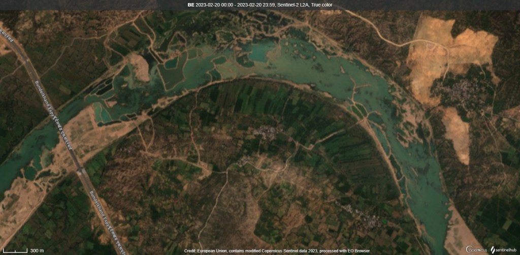
| 6 | Haidalpur, Bandhauli/ Dakore/ Jalaun Chikasi, Suzguwan, Hardua, Bareda Khalsa Sarila/ Hamirpur | 25.843387 79.479756 | ~7.06 sqkm | Massive scale, mechanized riverbed mining on both banks up & down stream Bundelkhand express way visible, Over 40 big, small deep pits & ponds created in riverbed, Several cross sectional, linear bunds built in flowing river channel, River struggling to flow, Water quality degraded by siltation |
| 7 | Kurauna, Orai/ Jalaun | 25.902856 79.610751 | ~0.17 sqkm | Excessive mining happening on right bank. About 18 big small deep ponds created in riverbed. |
| 8 | Kahata, Orai/ Jalaun | 25.90620 79.65976 | ~0.11 sqkm | Excessive mining in middle of riverbed on right bank |
| 9 | Parsan, Orai/ Jalaun | 25.92177 79.68712 | ~0.73 sqkm | Excessive mining happening on both banks, Bunds extending into middle of river channel visible |
| 10 | Rirwa Bujurg, Sarila, Hamirpur | 25.903844 79.747573 | ~0.38 sqkm | Excessive mining on left bank created several deep pits in riverbed. A bund extended into middle of river obstructing flows |
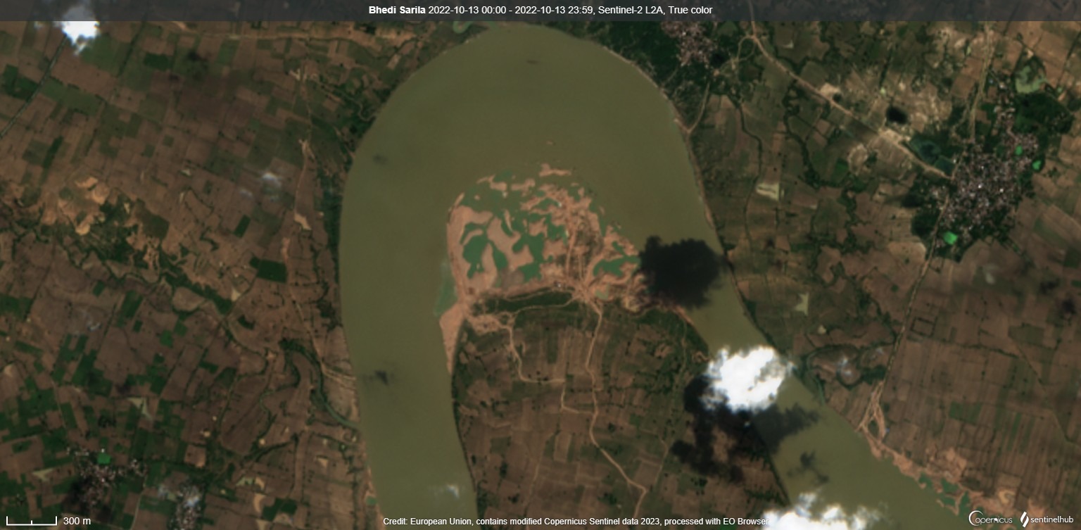
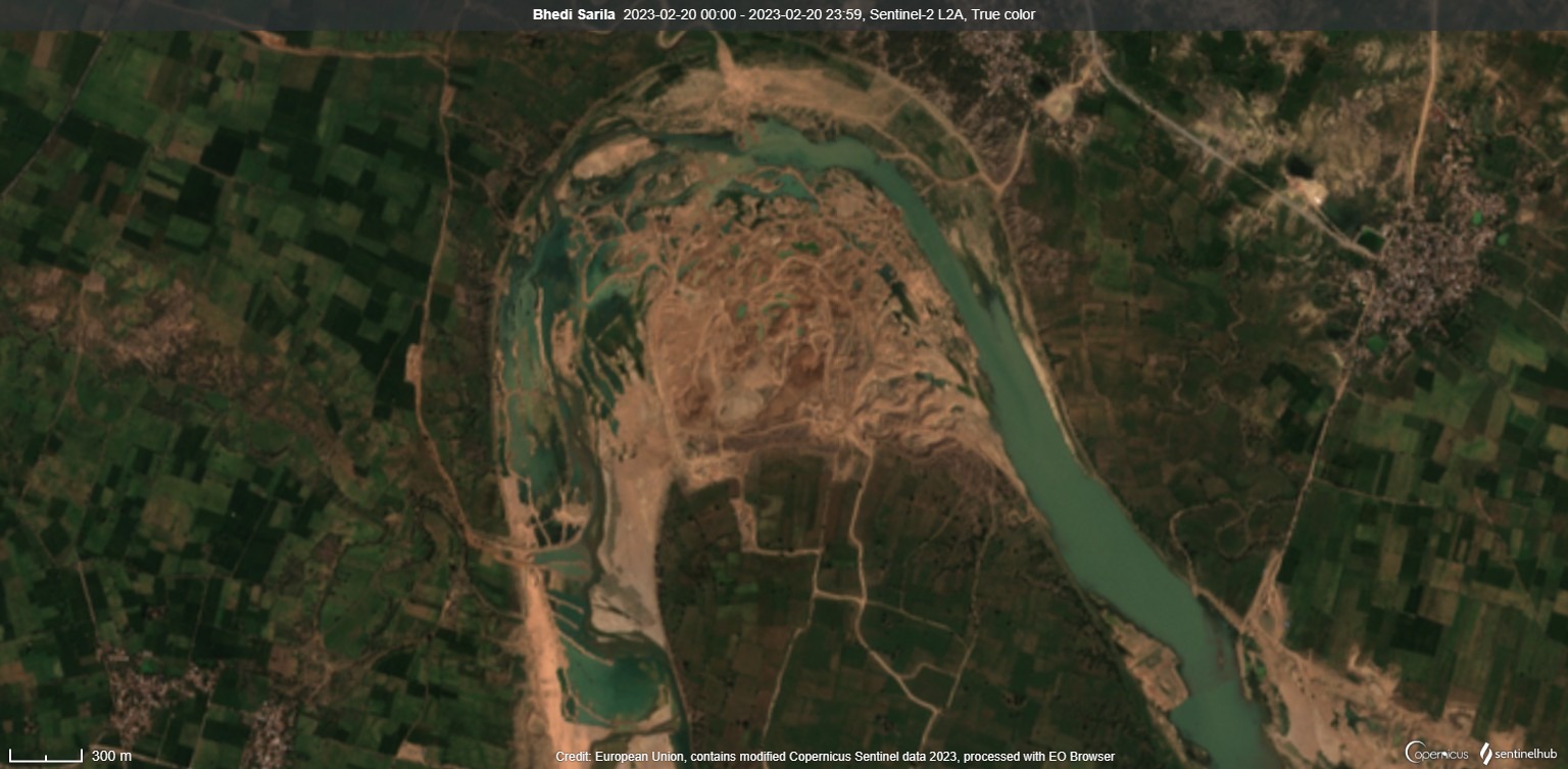
| 11 | Himanpura, Pathreta/ Orai/ Jalaun Bhedi Kharka, Sarila/ Hamirpur | 25.90112 79.80959 | ~4.90 sqkm | Massive scale mining happening on both banks Several vertical, horizontal bunds built in the river creating numbers of pits, ponds in riverbed River flows obstructed, Water quality impacted by siltation, |
| 12 | Beri, Orai/ Hamirpur Bhujpur, Sarila/ Hamirpur | 25.89009 79.89673 25.87886 79.90655 | ~1.82 sqkm | Excessive mining on both banks of river, Bunds, water pits, siltation load visible, |
| 13 | Bahdeena Acchpura, Maudaha/ Hamirpur Kandaur, Kurara/ Hamirpur | 25.90741 79.96877 25.88017 79.99079 | ~0.71 sqkm ~0.76 sqkm | Excessive mining, several water pits, bunds, siltation load visible in the river, |
Betwa is among key tributaries of Yamuna river in lower stretch. Like Chambal, Sindh, Ken rivers rising from Vindhya hill ranges, Betwa is also famous for light orange colour sand which is officially and locally known as ‘Morrum’ or Morang in Bundelkhand. Morrum is formed by weathering of granitic rocks. It has coarser and thicker grains than grey colour sand. These properties make Morrum of greater adhesive quality and of high value in construction activities.
However, the finite mineral is being mined in unsustainable and unlawful manner. Previously, SANDRP has highlighted brazen riverbed mining activities in Ken and Chambal river. This December 2022 report highlights the destructive riverbed mining happening in Sone river in Sonbhadra district of Uttar Pradesh.
For long distance, the Betwa river forms boundary between Jalaun and Hamirpur districts and satellite images reveal intensive mining in both districts along the river. At the same time, there is complete absence of effective monitoring and credible regulatory mechanism on behalf of the state government.
The mining intensity is seen increasing as the river descends rocky terrain. About 100 km long stretch between Dhasan-Betwa and Yamuna-Betwa confluences is being heavily mined at multiple locations. In-stream and mining at meanders is common practice. Just few km upstream to its confluence even the Dhasan river is facing destructive mining operations. Near Bundelkhand Expressway Bridge and Bhedi Kharka about 7 and 5 km long stretches of Betwa river is totally ravaged by intensive mining.
As per Directorate of Geology and Mining (M&G) Department, Uttar Pradesh website, there are 238 Murram mining sites in 9 districts of the state of which 80 sites are in Hamirpur (52), Jalaun (28) districts where Murram mining is taking place on 4036 acres of river land since 2018-19 for a period of 5 years. The website mentions that of the 80 sites 56 are active and 24 closed. Similarly, there are 20 mining sites in Jhansi district of which 14 are mentioned as closed.
Although the five year long mining lease period is coming to an end, information for these sites were last updated in 2018 (4 sites) 2019 (47 sites) 2021 (11 sites) and 2022 (only one site) while 16 sites are without any update. The other information including dispatched and approved quantity of minerals and selling price is mostly incomplete. (Please see the details in PDF file of information on Murram mining sites in Hamirpur, Jalaun districts as obtained from Directorate M&G Dept., UP website on Feb. 16, 2023.)
Moreover, the District Survey Reports (DSR) as recommended by Ministry of Environment, Forest & Climate Change (MoEF&CC) and ordered by National Green Tribunal (NGT) for obtaining Environment Clearance (EC) before approving riverbed mining are not uploaded on the website.
Surprisingly, the website does not even mention the rivers name leased out for the mining in Jhansi, Jalaun, Hamirpur districts. It has no information, link on DSRs, replenishment studies, EIA, EC documents, monitoring system which should ideally be there.
When on February 16, 2023, we made an inquiry regarding the riverbed mining DSRs for Jalaun and Hamirpur districts; Subash Singh, Mines Officer, Hamirpur replied that DSRs are available with Directorate General (DG) and not in public domain. Regarding mineral replenishment study in Betwa river; he claimed that it has been done by Central Mine Planning & Design Institute Limited (CMPDI) but they do not have the report. There is no such report uploaded on CMPDI website.
When further asked about any action against multiple violations as visible on updated satellite images, the Mines Officer refused to share any information saying it would be provided after a person gets written permission from DG for the same.
Though mining norms clearly prohibit construction of bunds, in-stream mining, ponding effect in riverbed, use of heavy machines, digging dipper than water table, diversion of river flows etc., however the Sentinel satellite images testify that there is no implementation of these norms by regulators.
Clearly, the miners are using heavy machines to impound, divert river flows at will. The discontinuity of river course, impoundment of flows and increase in siltation load are bound to affect the river morphology, hydrology, aquatic biodiversity adversely. Generally these problems go unaddressed in mining plans and slip through inadequate monitoring mechanism.
The illegal sand mining in Betwa river has been big political issue during previous government regime in 2015-16. A Central Bureau of Investigation (CBI) probe is still ongoing in the matter incriminating the then Mining Minister and District Magistrate, Hamirpur. Similarly, the NGT has also heard pleas on unsustainable riverbed mining in Betwa in recent past.
Nevertheless, the ground situation appears only worsening and requires execution of mining plans only after credible DSRs, replenishment study; effective implementation of rules on urgent basis for mitigation of immediate and long term adverse impacts of unsustainable and unlawful Murram mining operations on Betwa river eco-system.
Bhim Singh Rawat (bhim.sandrp@gmail.com)
