Belagavi district (earlier known as Belgaum) in Northern Karnataka is the worst affected among the Krishna Basin Flood affected districts in August 2019. As the state Chief Minister and Union Home Minister visit the area to take stock of the situation, it would help to understand the reasons for these unprecedented floods.
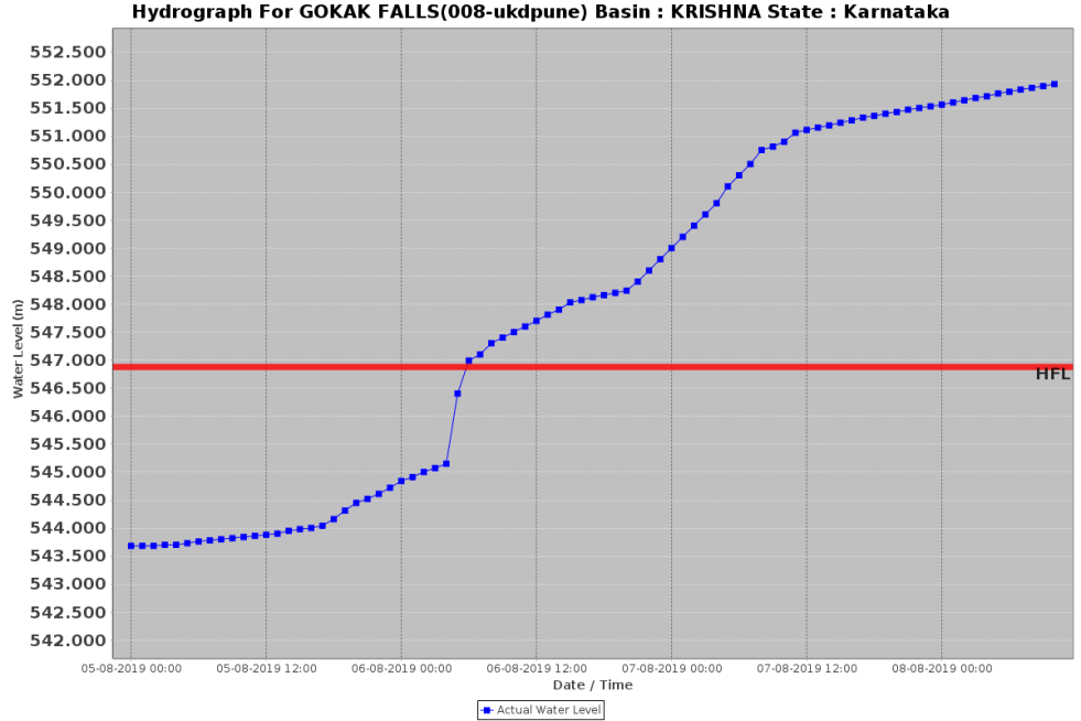
Unprecedented Floods One of the signs of the unprecedented floods[i] is the following flood hydrograph (from CWC: Central Water Commission) of the site Gokak Falls along the Ghataprabha river in Belagavi district. It shows that the water level of the river at this site crossed the HFL (HIGHEST Flood Level recorded at this site) of 546.88 m (reached on Aug 23, 2005) at around 6 am on Aug 5 2019. The water level at this site than reached a new peak of 553.08 m around 11 pm on Aug 9, 2019 and the water level remained above the HFL as I write this further 48 hours later, even as CWC’s flood forecasting site is down for the whole day on Aug 11, 2019 and even on Aug 12, 2019. It means that the new flood peak for this site is about 6.2 m above the previous HFL and the water level has remained above the HFL for six days and 17 hours already! Both these are unprecedented and shows how unprecedented the current rounds of floods are.


Similarly, the flood hydrograph at Mudhol in the Bagalkot district shows that the earlier HFL of 538.25 m for this site was crossed at 1300 hrs on Aug 6, 2019 and reached a new peak of 544.7 m at 0000 hrs on Aug 10, the new peak again being massive 6.45 m above the previous HFL.


High Rainfall There is no doubt that high rainfall is one of the reasons for these floods. IMD has reported that Belagavi district has received 135% above normal rains till 8.30 am on Aug 11, 2019. As on Aug 1, the district rainfall was bout 32% above normal. This means that between Aug 1 and 11, the district received 868% above normal rainfall. This is quite high, no doubt. It translates to 469.7 mm rainfall spread over 10 days, which means around 47 mm rainfall per day. Is that unmanageable? Can it alone lead to unprecedented floods? Clearly, the answer is no.
Role of dams This than brings our attention to another possibility: Were there dams in the district that released lot of water during the flooding that started on Aug 5 and 6 as we can see from the CWC flood hydrograph mentioned above. There are many dams in the district, but three are relevant here: Ghataprabha, Malaprabha and Almatti. Almatti is in downstream Bagalkot district, but the filling and the water releases from Almatti is likely to have impact on Ghataprabha and Malaprabha rivers as Ghataprabha meets Krishna just upstream of Almatti and Malaprabha confluences with Krishna downstream from Almatti reservoir.
Fortunately, the website of the Karnataka State Natural Disaster Monitoring Centre[ii] provides some very useful information about selected large reservoirs of the state where daily reservoir level, storage, inflow and outflow figures are given. Such information is not available for any dams from any other source.
Ghataprabha Reservoir The FRL (Full Reservoir Level) of the 62.48 m high Hidkal Dam on Ghataprabha River is 2175 ft or 662.95 m and live storage capacity at this level is 48.98 TMC (Thousand Million Cubic Meters) or 1.391 Billion Cubic Meters. On July 2, hardly 5% of live storage capacity was filled up, but by Aug 6, 96% of the live storage was full with water level at 2171.58 ft. This 96% filled up dam on Aug 6 was in complete violation of dam filling rules and in complete violation of what is called rule curve. Rule Curve provides date wise filling range for the dam operators and dams are not supposed to be filled up at the first instance when water is available. Why was Ghataprabha dam filled up to 96% by Aug 6, when monsoon was hardly halfway through? This was sure invitation to trouble, since from that date, the dam operators have no choice but to release all the inflows, irrespective of the state of the river downstream, and carrying capacity of the river downstream. What if there were to be heavy rains both in upstream and downstream of the dam after the dam is filled up. In that case, the dam will end up adding to the downstream flood disaster.
That is exactly what happened in Belagavi district. The water releases from the Hidkal dam till Aug 5 were around paltry 2400 cusecs. As soon as the dam was full, the water releases went up to 29429 cusecs on Aug 6, and which then kept climbing upto 100945 cusecs on Aug 9. The excess release that thus started on Aug 6 coincided with the flood peak that CWC flood hydrograph shows, showing such huge influence that Hidkal dam releases had on the floods along Ghataprabha river in Belagavi district from Aug 6, 2019. The water releases from the Hidkal dam remained over 90000 cusecs till Aug 10. It was only on Aug 11 that releases came down a bit to 52320 cusecs, as inflows to the dam decreased, and this drop in outflows had immediate impact on the drop in flood peak in CWC hydrograph.
If only the Hidkal dam operators had started releasing water from the dam say on July 23, when the dam was about 55% full, the dam could have absorbed large proportion of the excess inflows from July 30. In that case the outflows from the dam may not have exceeded 20-25000 cusecs on any date, thus reducing the flood peaks due to over 50 000 cusecs that the dam released.
This shows that even though the Hidkal dam intercepts only 1412 sq km catchment (though the dam catchment, being part of the western ghats, is likely to have higher rainfall than the downstream catchment) of the 8829 sq km area of Ghataprabha basin, it can have just big influence on the downstream river floods.
Why advance releases were justified Did the dam operators have sufficient reason to start releases from the dam say on July 23 or even July 30? Indeed, the high rainfall event in Belagavi started on July 29, which had immediate impact on the inflows into the Hidkal dam from July 30. Considering that IMD provides fairly reliable and accurate predictions of rainfall about five days in advance, there was sufficient reason for the Hidkal dam operators to start releasing more water from the dam from July 23 or even July 29/30. The fact that the dam was already 55% full on July 23 and over 60% full on July 29 provided another reason for such releases. But as is usual, Hidkal dam operators waited for the dam to be almost full before starting to release water from the dam, adding to the flood disaster in the downstream area significantly. So the dam that was supposed to help moderate the flood ended up adding to the flood disaster.
How the Malprabha Dam Operation added to the flood disaster Similarly, the Malprabha reservoir (also known as Renukasagara dam), also in the same Belagavi district, has FRL of 633.83 m or 2079.5 ft, with live storage capacity of 34.35 TMC or 0.972 BCM. The 43.13 m high dam catchment area is 2564 sq km out of total catchment area of the Malaprabha basin of 11549 sq km. Similar to Ghataprabha dam, the operators here too filled up the dam to 100% before starting to increase the outflow to 81048 cusecs on Aug 8, from just around 200 cusecs the previous week. This massive increase in water release from the dam coincided with the unprecedented floods in Belagavi in particular and North Karnataka/ Krishna basin in general.
The question again arises, why was the dam filled up to 100% on Aug 8, when monsoon was just halfway through? Why was the rule curve violated? Why was the water not released starting from say July 30 when water storage was just below 50%, which would have hugely reduced the contribution of the dam to the Belagavi / Krishna floods? Will the dam operators be held accountable for this mismanagement that led to Malaprabha dam harming rather than helping in the flood disaster?
Mismanagement at Almatti Dam A perusal of the information about Almatti dam, the biggest Krishna basin reservoir of Karnataka, makes even more shocking reading. This dam with FRL of 1704.81 ft/ 519.6 m, has live storage capacity of 119.26 TMC/ 3.105 BCM. The massive reservoir was already filled upto 1703.99 ft by July 28, which means dam was already over 99.5% full even before the end of July, with almost two full months of monsoon to go. Even till July 27, the outflow from the dam was just 3045 cusecs. This was again in complete violation of the rule curve and prudent reservoir management. The dam operators were left with no option but to start releasing more water, starting from 27095 cusecs on July 28 to 504802 cusecs on Aug 11, even depleting the reservoir to 1697.92 ft by Aug 11, but that did not help too much, it was a losing battle against mounting inflows, that peaked to 600049 cusecs on Aug 11. Almatti dam also hugely contributed to the backwater impact in the upstream Maharashtra districts of Kolhapur and Sangli. Will the Almatti dam operators be held accountable for this mismanagement and clear violation of rule curve?
Responsible Agencies Besides the operators of all the individual large dams in the Krishna basin, responsible officials of the water resources departments of Maharashtra and Karnataka should be held accountable for the serious lapses in operation of each of the dams that contributed to the flood disaster. In addition, the CWC, which is the sole agency tasked with flood forecasting in India, which also approves the Rule Curves for operation of all the large dams, monitors reservoir operation, and formulates flood management policies, also needs to be held accountable. Unfortunately, working more like a lobby for large dams, CWC promptly comes up in defense of the dam operators, the way they did after the Aug 2018 Kerala floods. This also underlines how inappropriate it is to have CWC as the main body responsible for Dam Safety under the Dam Safety Act, now before the parliament. This whole episode again underlines how important is to include operational safety under the Dam Safety Act, which is hardly adequately taken care of currently. The need for non govt, independent persons and complete transparency in the Dam Safety Mechanisms at every level also gets emphasis in the process.
How Dam floods are different than natural river floods When this author raised the issue of mismanagement of dam operation in discussion with Shri U P Singh, Secretary, Union Ministry of Water Resources on Aug 10 on an All India Radio program, he was quick to respond that the dams do not create floods! This response completely misses the reality that the floods that happen in a dammed river are very different that the floods in an undammed river[iii]. The carrying capacity of the river, the encroachments of and dumping of wastes in the floodplains and riverbed, the sudden-ness, the intensity, the hungry silt free river and state of biodiversity, everything makes the flood released by dams more damaging than the flood in the natural river. The Secretary and the CWC engineers know that well. The question is, when will this knowledge translate into action?
Himanshu Thakkar (ht.sandrp@gmail.com)
END NOTES:
[i] See for earlier article on these floods: https://sandrp.in/2019/08/08/aug-2019-krishna-basin-floods-in-maharashtra-karnataka-how-dams-harming-rather-than-helping/
[ii] http://www.ksndmc.org/Reservoir_Details.aspx
[iii] For details, see: https://www.epw.in/journal/2018/38/commentary/role-dams-keralas-flood-disaster.html

Respected Madam Sending video highlighting ecological degradation of Western ghats. Atul Karnik Video from Atul Karnik
LikeLike