According to IMD, India is having normal monsoon this year, so far, as per rainfall till date (Sept 1, 2018). Against normal rainfall of 721.1 mm, India has received 676.6 mm rainfall, which is 6.2% below normal, considered within normal rainfall definition as per IMD. So India is having normal monsoon rainfall, says IMD. Let us check this against some ground realities.
However, East and North East India, one of the four regions for which IMD provides rainfall data, has so far had 27% below normal rainfall, while South India had 9% surplus rainfall. Thus, while at all India level, what seems all normal, is average of different, though serious departures from normal rainfall. Let us say this is first level of mirage of normal rainfall.
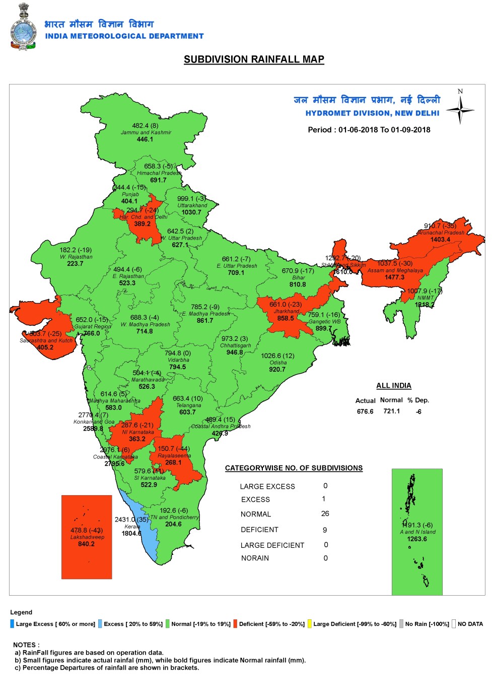
If we go from regions to IMD’s 36 sub-divisions, we see that deficits are even more serious: Rayalseema (-44%); Lakshadweep (-43%); Haryana, Chandigarh and Delhi (-25%); North Interior Karnataka; Saurashtra and Kutch; Western Rajasthan; Tamil Nadu & Pondicherry all show substantial deficits. Please note that all of them are traditionally low rainfall sub-divisions, and they are the ones facing some of the biggest deficits or below normal rainfalls. In all 11 sub-divisions have deficient rainfall, while Kerala, incidentally, one of the heavier rainfall area, is the only sub-division that has excess rainfall. So while South India as a region was shown to have surplus rainfall, sub-divisions like Rayalseema and North Interior Karnataka were showing one of the highest rainfall deficits. Let us say this is second level of mirage of normal rainfall.
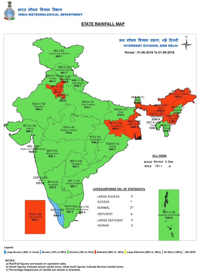
If we look at state level rainfall figures (boundaries of most states do not coincide with the 36 meteorological sub-divisions of IMD), we see for example that while IMD sub-division NMMT (Nagaland, Manipur, Mizoram, Tripura) has received 21% below normal rainfall, Manipur as a state has experienced the biggest rainfall deficit among all states of India, at 68%, with rainfall of 364.3 mm till Aug 29. This shows how sub-divisional rainfall can be misleading. Call it third level of mirage of normal rainfall.
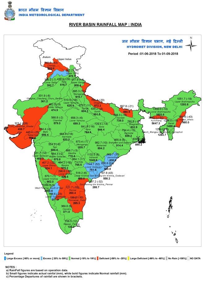
IMD also provides river-basin wise rainfall. Here some of the highest deficits can be seen in: Imphal and other rivers: 67%; Pennar: 53%; Pannaiyar-Palar: 35%; Cheab: 40%; all these getting below 350 mm rainfall. Pennar and Pannaiyar-Palar are river basins in South Indian Region, where IMD has reported 12% surplus rains. May be we can call it fourth kind of mirage of normal rain.
Fifth level of mirage of normal monsoon Within states also we see huge discrepancies.
- So for example, while Assam has seen 26% below normal rainfall (and yet experienced multiple rounds of floods), Dhemaji district has received just 12% of normal rainfall, experiencing one of the highest rainfall shortfall of 88%.
- Odisha has received 11% above normal rain, but Puri district in that state has received 66% above normal rainfall, one of the highest surplus rainfall districts of India.
- Jharkhand has 25% below normal rainfall so far, but some of the districts are much worse, including Khunti (-63%), Garhwa (-50%), Kodarma (-49%), Pakur (-48%). Purbi Singhbhum in Jharkhand, incidentally, received 18% above average rainfall.
- Bihar is another state that has received high deficit rainfall this year at 20% below normal rains. Some districts that have experienced much higher rainfall departures in the state include: Saharsha (-52%), Vaishali (-49%), Saran (-48%). Bihar also has a district like Buxar, where rainfall is 41% ABOVE average! Incidentally, while Bihar is having such huge rainfall shortfall, Ganga water level remains above warning level at several locations, including Patna Gandhighat, Hathidah and Kahalgaon, and also Sahibganj and Farakka in downstream locations. Interestingly, all of them crossed the warning level only around Aug 1 and interestingly, all of them have remained above warning level almost throughout August! Farakka effect?
- While Uttar Pradesh had 7% below normal rainfall, we have districts like Kannuaj with 60% above normal rainfall and Kushinagar with 81% below normal rainfall.
- In Uttarakhand, with 3% below normal rainfall, Bageshwar had 85% above normal rainfall.
- Jammu and Kashmir had 9% above normal rainfall, where Bandipore had unprecedented 226% above normal and Kulgam had 89% above normal rainfall.
- Gujarat had 18% below normal rainfall, where Gir Somnath had 83% above normal rainfall.

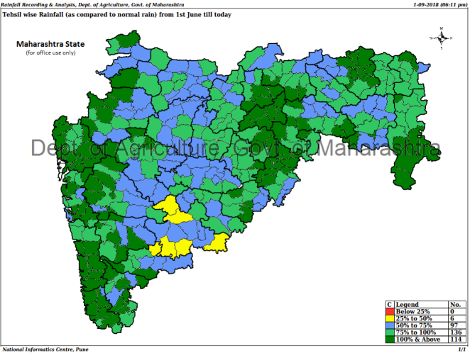
Sixth levels of mirage of normal monsoon Maharashtra so far has 6% above normal rainfall, but district like Solapur has rainfall deficit of 47.6%, one of the highest in the state. The state government has a website[i] that provides district wise, taluka wise and circle wise rainfall. Some examples that show the sixth level of mirage of normal rainfall.
- Satara district so far has 13.2% surplus rainfall, Mahabaleshwar taluka here has had 174.3% above normal rains.
- Pune district had 14.8% above normal rainfall, where Maval Wadgaon taluka had 123.1% above normal rainfall and Shirur Ghodnandi taluka had 40.9% below normal rainfall.
- Akola district had 11.1% above normal rainfall, where Telhara taluka had 25.2% below normal, while Barshitakhi taluka had 68.1% above normal rainfall.
- Karmala taluka in Solapur district has so far seen rainfall of just 101.3 mm, a shocking deficit of 65.1%. Compared that with state average of 6% surplus rainfall.

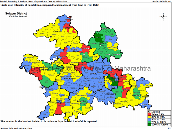
Seventh level of mirage of normal monsoon Some of the highest rainfall departures in Maharashtra at circle level is listed below, providing the contrast with state or district or even taluka level rainfall. The Seventh level of mirage of normal rainfall.
- Solapur district: Mardi: 89.8% deficit (rainfall of just 35.6 mm); Temburni: 88.9% (30.6 mm); Shetfal: 88.1% (38 mm); Ranzani: 85.8% (39 mm).
- Pune district: Bholawade: 369.2 % surplus rainfall (3522 mm); Lonawala: 367% (4585 mm); Rajur: 384.4% (2394 mm)
- Satara district: Lamaj: 297.1% surplus rains (7258.1 mm); Tapola: 228.6% (6002.9 mm); Mahabaleshwar: 216.4% (5779.5 mm). The same district had circles like Kudal with deficit of 80.2% and Talmanle with deficit of 71.1%.
- Nasik district: Nandur circle had 89.1% deficit with rainfall of just 37.5 mm; Wavi has 83.7% deficit withrainfallof56 mm and Shaha has deficit of 78.6% with rainfall of 73.3 mm; Sayane has 81.3% deficit with rainfall of 59 mm; Nimgaon deficit is 85.1% with rainfall of 47 mm.

The Eighth level of mirage would be reflected if we had village level rainfall!
Here a shocking fact needs to be noted that in this day and age, IMD has NO DATA for rainfall for at least 17 districts in North East India! In fact, in whole of India, IMD has 20 districts where it does not even have district level rainfall data, three of them are in Jammu & Kashmir and rest 17 in North East India.
Some people will say oh, but the local abnormality within national normal rains is to be expected. May be to some extent. However, the problem is if overwhelming number of villages, circles, taluks, districts or even states see such huge departure from the picture of normal rainfall that we are given at national level, how are these figures of any help either to the farmers, the governments, or even the policy makers? Why will the overwhelming sections of people accept or identify with the national picture of normal rainfall?
The picture we have given here reflects the spatial variations, we can go into similar analysis to look at temporal variations within the monsoon to show how the normal monsoon is also a mirage from temporal distribution of rain, which is equally important for the farmers.
This also applies, even more significantly, to the IMD’s rainfall forecasts, we need forecasts to be much more localized in space and time to be useful.
Climate scientists are telling us that this kind of anomalies are going to only increase in future.
Look at the Cauvery basin to see another kind of anomaly playing out. The basin has just 4% above normal rainfall till Aug 30. And yet all the big dams in the basin were full by end of July and there are floods in parts of the basin, in Kerala, Karnataka and even Tamil Nadu. This is not climate change. One possible reason is degradation of the catchment. What does degradation of the catchment mean? It means that the capacity of the catchments to hold and recharge the rainwater is reducing. This is catastrophic from several different perspectives.
So what can be done. That will need another article. But briefly, we need to reverse the degradation of catchment in Cauvery basin and everywhere else. Increase the catchment’s capacity to hold and recharge water. Through forests, wetlands, local water systems, by increasing soil’s capacity everywhere to hold more moisture, say by increasing organic/ carbon content. That will also help better sustain our groundwater lifeline. Along with all this, we need to also work towards community regulation of groundwater use.
Himanshu Thakkar (ht.sandrp@gmail.com, https://sandrp.in/)
END NOTES:
