
“Bolo Jai Jai Baba Bhole”, the Prime Minister Narendrabhai Modi, while speaking at Kedarnath in Uttarakhand in Oct 2017[i], asked the people in audience to chant with him. Indian deity Mahadev, the presiding deity at Kedarnath on the banks of Mandakini river is possibly the closest to rivers and nature among all the deities, as is also clear from his attire. Baba Bhole is one of the many names of this deity. Incidentally, the massive, controversial Pancheshwar Dam a pet project of Mr Modi will also submerge the Pancheshwar Mahadev Temple, where too, the presiding deity is same Bhole Baba. But we will come back to Bhole Baba.
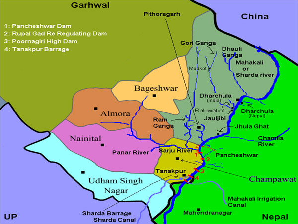
Unprecedented scale of the project The Pancheshwar Dam is proposed on Mahakali river, at about 2.5 km downstream of confluence of Saryu with Mahakali along the India-Nepal Border. The 315 m high dam (dam height is measured from the deepest foundation level) will the world’s tallest dam[ii], full 10 m higher than Jinping-I dam of China, current tallest completed dam of the world at 305 m[iii] and full 54.5 m taller than Tehri Dam, India’s current tallest dam at 260.5 m. Pancheshwar is proposed to be a Rock fill dam with clay core. The tallest existing dam of this type in the world is of 169 m height (Ataturk Dam in Turkey), close to half the height of the proposed Pancheshwar Project. This shows how unprecedented this venture is. But there are more unprecedented features here.
The PMP will have a massive reservoir with storage capacity of 11.35 Billion Cubic Meters (BCM) with reservoir area of 11600 ha. If built, it will be the third largest reservoir of India after Indirasagar on Narmada (Storage capacity 12.2 BCM, reservoir area – 91348 ha) and Nagarjunsagar on Krishna (11.56 BCM, reservoir area – 29490 ha) river. It will be THE largest reservoir in Indian Himalayas. With much lower reservoir area than Indirasagar or Nagarjunsagar, the weight exerted by the Pancheshwar exerted per unit area will be much higher than either of these two projects with comparable reservoir capacity, and highest among all the Himalayan reservoirs.
PMP is proposed to have installed hydropower capacity of 5040 MW, which is several times higher than installed capacity of any existing hydropower project in India. The largest capacity existing hydro project in India is the Nathpa Jakhri Project with installed capacity of 1500 MW and largest capacity under construction hydro power project in India is the 2000 MW Lower Subansiri Project, which has remained stalled since Dec 2011 due to agitation in Assam. Among many reasons why Lower Subansiri project remains stalled is the shoddy Environment Impact Assessment, including non existing downstream impact assessment or disaster impact assessment and violations in public consultation process and shockingly poor environment appraisal. All these also feature very prominently in case of PMP, as we see below.
One would have thought that when such an unprecedented project is being proposed, there will be credible environment and social impact assessment. One would have expected that there would be genuine, transparent and participatory public consultation process in which law of the land, democratic spirit would be respected. One would have liked to see a full scale disaster impact assessment and management plan. One looked forward to see confidence inspiring cost benefit analysis, application of precautionary principles, genuine application of lessons learnt from the past including Uttarakhand flood disaster of June 2013 which also affected this area and also from the past earthquakes in the Himalayas. The EIA & SIA were expected to be done by a credible agency with exemplary track record and no conflict of interest. It was necessary that there would be credible appraisal of the project by an independent Expert Appraisal Committee, without any conflict of interest issues. One expected the Ministry of Environment and Forests to stick to its core mandate of protecting the environment and people, taking into account climate change, options assessment and all the social impacts. International law required that there be a joint Indo-Nepal impact assessment of the project as basis for the consultation and appraisal process.
Unfortunately, in all this we only face utter disappointment.
Incidentally, the Pancheshwar Multipurpose Project (PMP) has another big dam, among other features. The 95 m high Re-regulating dam at Rupaligad, 27 km downstream from the Pancheshwar dam, is proposed to be a concrete gravity dam.
Project Authorities cannot even get the map right? The map hosted by the official site of the Pancheshwar Multipurpose Project[iv] shows that Saryu flows SW from Bageshwar and running through Almora District, before running east along the border of Almora and Nainital Districts, which is totally incorrect. In reality, the Saryu River flows SE from Bageshwar and marks the border between Almora District and Pithoragarh District. As the headline in local newspaper highlighted, if the project authorities cannot get even their maps right, what hope is that the project decision or construction will be right?
Earthquake prone area The Pancheshwar Dam is to come up in one of the most seismically active areas of India. In fact, there has been no major earthquake in this area for so long now that the seismologists are afraid that next one to hit this area could be really big one with magnitude above 8.5 on Richter scale. Here it may be remembered that the April-May 2015 Gorkha earthquake of Nepal did not help release the accumulated seismic energy of the area, since almost all the aftershocks of the Gorkha earthquake occurred to the east of the epicenter, with almost none to the west, where the Mahakali basin is located.
The EIA mentions only one earthquake in the area: the 1980 earthquake of magnitude 6.5. But does not mention that on May 30, 1833, an earthquake of magnitude 7.5 struck Lohaghat or Lohughar as it is recorded, hardly 15 km from the Pancheshwar dam site. This is among several other significant earthquakes in the area.
Besides the inherent seismicity of the area, the massive reservoir could also have what scientists call Reservoir Induce Seismicity (RIS). Koyna is one of the well known example of dams that caused RIS. Here it would be useful to note that the reservoir area of Koyna dam (reservoir area of 11500 ha) is comparable to that of Pancheshwar dam (11600 ha), but the storage capacity of Pancheshwar (11.35 BCM) being over four times that of Koyna (2.8 BCM), the impact of Pancheshwar Dam on the geology of the area could be much higher than what Koyna could induce. Add to it the fact that Pancheshwar is proposed in an area known to be seismically VERY active, unlike the Koyna dam area, where seismic activity was almost unknown till the Koyna dam came up.

Disaster Vulnerable Himalayas In fact, seismicity and RIS are not the only hazards that the Pancheshwar Dam faces. The Himalayas are known to face a number of other high vulnerabilities including floods (including flash floods), Landslides, Erosion, Landslide dams, Glacial Lake Outburst Floods, among others.
The Environment Impact Assessment (EIA) of the project says (Section 6.4.2), “The Geological Survey of India, at the instance of WAPCOS Ltd. has taken up a project of landslide hazard zonation mapping of the reservoir domain and the studies are in progress. On availability of the result of ongoing studies, the reservoir competency issues vis-à-vis landslide potential shall have to be further evaluated.” The EIA thus confirms that the landslide hazard zonation is yet to be mapped and the reservoir competency study is still to be evaluated. How can the EIA be complete without these?
A report in Hindi Daily Amar Ujala on January 3, 2018[v] suggests that the rocks at current dam location for the proposed Pancheshwar dam are not suitable for dam construction and WAPCOS have been given work to drill/ blast two more test tunnels to finalise the location of dam. This inappropriate rocks at the foundation is not even mentioned in EIA. If the location of the dam is to be changed, as suggested in this report, then clearly the dam impacts will change and will need fresh EIA and public hearings and appraisal.
Key point here is to first assess the disaster potential of the area, which the EIA has failed to assess. The next step would be how the project construction and operation would change the disaster potential of the area and third step would be to assess how the project will perform in these circumstances. None of these assessments have been completed by the EIA, the last two have not even been attempted.

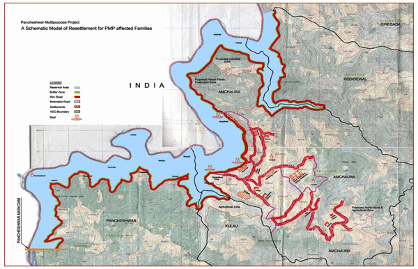
Project impacts The project will have submergence area of 11600 ha, 7600 ha of which is in India and 4000 ha in Nepal. The EIA states that 123 villages will be affected in India. In Nepal, 25 VDCs and one municipality is expected to face submergence. But these figures are based on totally shoddy Social Impact Assessment. It also does not include backwater impacts. The impacts due to Rupaligad Dam, the downstream impacts and also roads, townships, mining, muck dumping and other components of the project will be additional and remains totally unassessed. The disaster impact assessment will throw light on additional implied impacts. The Impact assessment done in Nepal part of the project is not even available on the Nepal govt website, nor is it part of the EIA done in India or the project that is under appraisal with MoEF and EAC. The Minutes of the Dec 5, 207 meeting of EAC[vi] notes that the Nepal part of EIA is now available with EAC, but it has not yet been put up in public domain.
Mahakali Treaty The project was initiated through the Feb 1996 Mahakali Treaty between India and Nepal, but the treaty has become outdated as many provisions of the treaty stand violated. Within Nepal, there has been debate about constitutional validity of the treaty. More recently, there has been questions about certain “unfair” provisions in the treaty that protects the “existing” water use from the river by both the countries, Nepal officials see this as an unfair precedent. Considering the prevailing atmosphere of mistrust between India and Nepal, which has become worse in recent years following blockade during Madhesi agitation in Nepal, and also considering the history of stalled Indo Nepal Projects, not many are convinced that this is the best option for progress for Indo Nepal relations.
WAPCOS: poor track record, conflict of interest The EIA for the project has been done by WAPCOS[vii] (Water and Power Consultancy Organisation), an agency under Union Ministry of Water Resources. Union Ministry of Water Resources is the developing, lobbying organisation for this project. The EIA is supposed to be done by an independent organisation, which WAPCOS is not. One of the possible conclusions of the EIA could be that the project is environmentally unviable or its impacts are unacceptable. One cannot expect WAPCOS to reach such a conclusion, since it is working under the project development agency. In fact, as the EIA makes is clear, WAPCOS has been involved in proving feasibility of the project since 1960s, and is still involved in doing all kinds of reports and testing for the project, as we saw from test tunnels report referred above. One does not expect such an agency now to turn around and conclude that the project is not the least cost option or that the project is not environmentally viable.
Callous, inadequate and shoddy EIA Lastly, WAPCOS has a very poor track record in doing EIAs, as many have repeatedly pointed out through analysis of various EIAs. Even in case of PMP, here are a couple of quick examples[viii] about how poor the EIA WAPCOS has done.
- In section 1.6 (p 9) the EIA says about the catchment area of the Mahakali river basin upto Pancheshwar dam site, “The Mahakali (Sarada) basin up to the Pancheshwar dam site has a total catchment area of 12,276 km2… Out of the total catchment, an area of 9,720 km2 of the river catchment lies in India, and 4,456 km2 in Nepal.” Now if we add the catchment area upto Pancheshwar Dam in India and Nepal, i.e. 9720+4456, we get 14,176 km2 and not 12, 276!
- In the next para, about catchment of the Mahakali river basin upto Purnagiri, located several kilometers downstream from Pancheshwar site, it says: “The total drainage area up to Purnagiri temple has been worked out to be around 14,922 sq km, out of which 10,884 sq km area lies in India and 4,038 sq km area in Nepal.” And now note that the Nepal catchment area in Mahakali basin has DECREASED as we go downstream! The Nepal catchment area upto Pancheshwar dam site is 4456 sq km as given in previous para, now, at Purnagiri temple, several kilometers downstream, it DECREASES to 4038 sq km.
- The EIA does not assess the downstream impacts, does not include the impact of irrigation component, does not include the project impacts in Nepal, does not include the impact of climate change on the project and how the project will hasten and worsen the climate change impacts, to list only a few aspects. Its impact on biodiversity is so shoddy that even a normally non critical EAC has asked them to redo it.
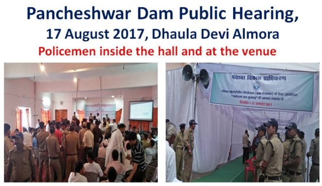
Public consultations? The public hearings for the project were held in Almora, Champawat and Pithoragarh districts in Aug 2017, that is, in the monsoon season when farmers are busy in agriculture. These seemed to have been designed to keep people ill informed and out of the public consultation process. There were more armed police in the public hearing location than the affected people at times. Those present were not even allowed to speak, even as the politicians took away most of the time. The public hearings had so many violations that it wont stand any legal scrutiny, but in India, unfortunately, you only need to tick mark the box (answer the question: Has public hearing been conducted?), not bother about what exactly happened at the public hearing. This was again proved in case of PMP. This shows that there is no respect for the law of the land either for the district magistrates and Pollution Control Board that conducted the public hearings, or for the MoEF and the EAC. Several detailed submissions informed the EAC about violations in the public consultation process before the Oct 24, 2017 EAC meeting where the project was considered for the first time. But the minutes of the EAC does not even acknowledge this reality!
Recently, there have been numerous protests in local area[ix] against tree marking for Pancheshwar Project. It only shows that protests against the project continue.
Wither Economic viability? The EIA of PMP clearly states that hydropower generation is the basic objective of the Project. India is currently power surplus and India has become net power exporting country, India’s Power Minister has repeatedly said on the floor of the Parliament and outside. He has also said how large hydropower projects with cumulative capacity in access of 11000 MW stands stranded, mostly for lack of economic viability. Studies show that India is likely to remain power surplus for decades to come. The recent most projection by international energy experts have shown that share of hydropower in India’s total electricity generation would drop to 3% by 2050, as most of the generation is projected to come from solar and wind. The cabinet note prepared just two months back for pushing the stranded hydropower projects showed that every MW of installed capacity from large hydro even from these ongoing projects is going to cost in excess of Rs 10 crore. This puts the conservative cost of PMP at over Rs 50 000 crores. The EIA report says that PMP is expected to generate 9116 Million Units of Power at 90% dependability. Even if this promise were to be fulfilled (unlikely considering track record of 90% of hydropower projects in India), this means every unit of power from PMP will be over Rs 6-8, at most conservative estimates. However, these days there are no takers at India’s power exchanges for any power costing over Rs 3 per unit. Nepal actually hopes to sell most of the power generated at PMP to India, since its own demands would be taken care of by the other ongoing and planned projects. But who will buy this expensive power in a surplus market? Its clear that even if we were to set aside the social and environmental costs and risks for a moment, even in terms of pure economics, the Pancheshwar project is totally unviable.
NDTV India (Hindi) recently did a fantastic program[x] (in Hindi) on Pancheshwar Dam related issues, a must watch for all interested.
In conclusion Coming to the question in the title of this article, who exactly will benefit from this unviable, unprecedentedly disastrous dam when it is clear that it is not required for electricity generation, its basic objective? For a project that would cost at least Rs 50 000 crores at current prices, there are of course many big and small contractors, consultants, engineers, bureaucrats, equipment supplies, cement companies, politicians and of course financers who will be seeing opportunities for big business. So are we going to allow the decision for such a disastrous, risky and unviable project for all these “stake holders”?
Coming back to where we started from, Mahadev is also called Bhole (the word Bhole means innocent or straight forward), and the Prime Minister was using this name when he was addressing the people at Kedarnath a day after 2017 Diwali. But can Baba Bhole, in spite of the name we have given him and the people of India and Nepal be fooled so easily in the name of development?
Himanshu Thakkar (ht.sandrp@gmail.com)
NOTE: An edited version of this was published as COVER STORY in January 2018 issue of CIVIL SOCIETY magazine, see: http://www.civilsocietyonline.com/cover-story/will-the-pancheshwar-dam-do-more-harm-than-good/.
- This site provides comprehensive information about Pancheshwar Project. https://savemahakali.wordpress.com/2018/01/04/the-pancheshwar-multipurpose-project-pmp-a-fact-sheet/.
END NOTES:
[i] https://www.youtube.com/watch?v=dh0Nv2inDm0
[ii] I should add here that this is among the existing dams. 335 m high Rogun Dam, is an embankment dam under construction on the Vakhsh River in southern Tajikistan. It is one of the planned hydroelectric power plants of Vakhsh Cascade. The dam is under construction for over three decades now, see: https://en.wikipedia.org/wiki/Rogun_Dam
[iii] https://en.wikipedia.org/wiki/List_of_tallest_dams
[iv] http://www.pmp.gov.np/maps.php
[v] https://www.amarujala.com/uttarakhand/champawat/construction-of-the-dam-will-start-after-the-results-of-rock-testing
[vi] http://environmentclearance.nic.in/writereaddata/Form-1A/Minutes/18122017AIB7BIJZEAC_MinutesFinal.pdf
[vii] http://www.wapcos.gov.in/
[viii] For details, see: https://sandrp.wordpress.com/2017/12/04/new-grounds-why-pancheshwar-dam-is-unviable-project/, https://sandrp.wordpress.com/2017/10/24/letter-to-moefs-expert-committee-why-pancheshwar-project-should-not-be-considered-for-environment-clearance/
[ix] http://epaper.livehindustan.com/story.aspx?id=2470950&boxid=95227624&ed_date=2018-01-08&ed_code=303&ed_page=5 (Hindustan Hindi, 08 January 2018), https://timesofindia.indiatimes.com/city/dehradun/pancheshwar-dam-locals-protest-counting-of-trees/articleshow/62356578.cms
[x] https://khabar.ndtv.com/video/show/prime-time/should-big-dams-be-built-in-the-himalayas-474091
