
This annual overview tracks the minutes of meetings held by Expert Appraisal Committee (EAC) for River Valley and Hydropower Projects between 20 December 2023 and 31 December 2024 for consideration of Dams, Hydroelectric Power (HEP), Pumped Storage Hydro Projects (PSP) and Irrigation related proposals seeking Terms of Reference (TOR) and Environment Clearance (EC) approvals. The analysis also covers various water projects related proposals considered by the Forest Appraisal Committee (FAC) between 15 December 2023 and 26 December 2024 for Forest Clearances (FC).
Continue reading “EAC & FAC Decisions on Dams, Hydro, Irrigation Projects in 2024”Tag: Irrigation Project
2022: Environment & Forest Clearances to Dams, Hydro, Irrigation Projects
On the basis of minutes of meetings held by Union Ministry of Environment, Forests and Climate Change’s (MoEF) Expert Appraisal Committee (EAC) for River Valley and Hydropower Projects from January 12, 2022 to November 30, 2022; we present region wise details of various Dams, Hydroelectric Power (HEP), Pumped Storage Hydro Projects (PSHP) and Irrigation Projects proposals considered and approved for Terms of Reference (TOR) and Environment Clearance (EC) by the EAC. It also lists out various water projects related proposals seeking Forest Clearances (FC) from and decisions by the Forest Appraisal Committee (FAC) of MoEF in this period.
SANDRP’s 2020 and 2021 overviews on the subject can be seen by clicking the links. You may also like to visit our 2022 overviews on (1) Dam induced floods & damages, (2) Fly ash dam breach incidents, (3) Impact of floods on Polavaram project, (4) People’s resistance against dams and hydro projects, (5) Disasters and accidents at HEPs sites, (6) Dam Safety Issues, (7) Hydro projects opposition and accidents in South Asia.
Continue reading “2022: Environment & Forest Clearances to Dams, Hydro, Irrigation Projects”
DRP 151121: District Level Vulnerability Assessment in India
This is the kind of study that was long overdue. In fact such a study should have been done before formulating India’s National Action Plan on Climate Change (NAPCC) as SANDRP has been saying since 2009 (see SANDRP critique of NAPCC published under the title “THERE IS NO HOPE HERE) when NAPCC was made public by a dozen wise individuals sitting in a room without any participatory or transparent exercise. One hopes that India will restart the exercise of fresh formulation of NAPCC after doing such a study on an urgent basis, on the lines of the study described below. In any case one hopes the union and state governments will wake up and take up District level vulnerability assessment in India in an independent way on urgent basis.
“This study undertakes a first-of-its-kind district-level vulnerability assessment of India, which maps exposure, sensitivity, and adaptive capacity using spatio-temporal analysis. To do this, we developed a climate vulnerability index (CVI) of Indian states and Union Territories (UTs). Instead of looking at climate extremes in isolation, we map the combined risk of hydro-met disasters and their compounded impacts on vulnerability. By doing so, we aim to inform policy goals in the resource-constrained context of India.
Continue reading “DRP 151121: District Level Vulnerability Assessment in India”
DRP: 1 Oct 2018: Hungry Water Effect due to Dams & Unsustainable Sand Mining Worsened Kerala Floods
Dams and reservoirs make rivers sediment-starved and menacing manifold downstream. While heavy rainfall is also a key factor behind the floods, hungry water had a more pronounced effect, says D. Padmalal, Scientist and Head, Hydrological process group, National Centre for Earth Science Studies.
– “When the sediment transport is interrupted, the potential energy of the hungry water released from dams will scour the river banks downstream, uprooting trees or riparian vegetation and damaging bridges and other engineering structures,” explains Dr. Padmalal. Overloaded with silt and clay from the eroding river banks, the highly turbid and viscous water clogs drainage channels. Subsequent discharge of water from the dam will lead to inundation and waterlogging of large areas.
– Hungry water can also develop in high gradient river channels devoid of adequate quantity of sand and gravel, especially during periods of high rainfall. “Years of uncontrolled sand mining have left most of the rivers in Kerala depleted or exhausted of sand and gravel. This creates a situation similar to the release of hungry water from dams,” notes Dr. Padmalal. When the river channel has adequate supply of sand and gravel, the potential energy of the water is used to transport the mixture. The water does not scour the banks or turn muddy.
Continue reading “DRP: 1 Oct 2018: Hungry Water Effect due to Dams & Unsustainable Sand Mining Worsened Kerala Floods”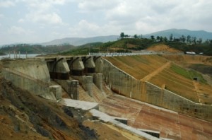
Analysis MoWR’s Advisory Committee’s Decisions for Northeast – January 2009 to Dec 2013
This is analysis of the decisions of the Advisory Committee in the Union Ministry of Water Resources for consideration of techno-economic viability of Irrigation, Flood Control and Multi Purpose Project Proposals (TAC in short) for North East India[1] from 95th meeting of January 2009 to 122nd meeting held in December 2013. In our last analysis of TAC minutes we have covered the decision taken for NE states from July 2011 to December 2013 which is available at – https://sandrp.wordpress.com/2014/03/19/lack-of-transparency-and-accountability-remains-the-norm-of-functioning-for-mowrs-advisory-committee/. In this analysis, we have covered the same for an extended period. In these five years TAC has accepted project proposals worth of 5515.46 crores. In calculating the total cost of the projects considered we have considered only the projects whose proposals were given clearance by TAC. In these five years, some of the projects also made two appearances with revised costs. In such cases the higher revised cost has been taken into consideration, e.g. Khuga Multipurpose Project and Dolaithabi Barrage Project, both located in Manipur were accepted by the committee in its 100th meeting (held on 9th October 2009) with revised cost of Rs 381.28 crore and 251.52 crore respectively. In the 115th meeting (held on 24th July 2012) of the TAC, these two projects were considered again where the cost for Khuga Project was Rs. 433.91 cr and for Dolaithabi Project it was Rs. 360.05 Cr. The same is the case for the Thoubal Multipurpose Project which appeared in 101st and 115th meeting of the TAC.
Within these five years, TAC has given financial clearance to 26 flood and erosion control projects and majority of these projects are from Assam. The committee gave the clearance to 6 irrigation projects, 3 barrage projects and 3 multipurpose projects.[2] The committee also gave clearance to a strom water drainage improvement project below Greenfield Airport at Pakyong in Sikkim within this period.
In this period, largest no of considered (25) and approved (20) projects were from Assam. Assam also has the maximum cost of projects among all states (Rs. 2631.99 Cr). Highest number of projects were considered (16) and approved (14) in the year 2009, with total cost of Rs 2321 Crores, which too was highest among all the years.
As found in our previous analysis, in the last five year from 2009 to 2013 TAC has not rejected a single project. Five projects had been deferred but were approved in the subsequent meetings within the same period. In the 108th meeting (held on 4th January 2011), the TAC did not discuss two projects on the Brahmaputra river stating “It was observed that the flood control and anti erosion scheme of Brahmaputra Board are implemented through Central Fund, which do not require investment clearance from the Planning Commission. Therefore, these schemes need not be put up to the Advisory Committee. However, the technical aspect of such project may be looked into by Central Water Commission as per past practice.” But both these projects were reconsidered in the 110th meeting of TAC (held on 20th July 2011) and were cleared by the committee.
So this seems like a rubber stamping committee, clearing everything that comes to it. Reading of the minutes of the meetings also reveals that there are hardly any critical questions asked on merits of the questions for the massive delay and cost escalations that most of the projects suffer. Nor is there an discussion about the performance of the projects.
As we noted earlier, this committee functions in most non transparent, non participatory and unaccountable way. Neither the minutes nor the agenda notes of the meetings are in public domain. Following our letters along with TAC analysis in April 2011, addressed to Planning Commission, Union Ministry of Water Resources, Central Water Commission and members of the National Advisory Council, for the first time, TAC minutes were put up on CWC website (see: http://www.cwc.gov.in/main/webpages/TAC%20minutes.html). However, the last uploaded minutes were for the 115th meeting held in July 2012, after which minutes have stopped being uploaded. Secondly, some of the links are not working and all the files are unnecessarily large PDF files since only scanned pages of the minutes are put up, in place of the PDFs of normal word files, which would be of much smaller size. The TAC also has no independent, non government members, all the members are government officials. As we wrote to MoWR and Planning Commission in April 2011 and again in March 2014, there is urgent need for TAC to have such members so that they provide objective perspective about the projects that come up before TAC.
The importance of functioning of this committee cannot be over emphasised. As we wrote in our letter to MoWR and Planning Commission, TAC “considers dozens of such projects with huge economic, social, environmental and other implications for the country in every one of its meetings. All of these projects are supposed to be public purpose projects, and are taken up using public resources. The Planning Commission accords investment clearance to the projects only after the TAC clearance. This Committee’s decisions are perhaps the ones which impact on India as a whole the most – as they relate to land and water – which are the basic life sustaining and livelihood providing resources for the people.”
It is high time that first effective steps are taken to ensure that the functioning of this committee becomes more transparent, participatory and accountable.
State-wise list of projects cleared by TAC
| State | No of Projects Considered | No of projects approved | Total cost of the projects |
| Arunachal Pradesh | 4 | 4 | 106.6 |
| Assam | 25 | 20 | 2631.99 |
| Manipur | 10 | 10 | 2268.99 |
| Meghalaya | 1 | 1 | 5.63 |
| Sikkim | 1 | 1 | 48.55 |
| Tripura | 6 | 6 | 453.7 |
Note: No projects from Mizoram and Nagaland have come to TAC in this 5 years period.
Year-wise List of Projects Cleared by TAC
| Year | No of Projects Considered | No of projects approved | Total cost of the projects |
| 2009 | 16 | 14 | 2321 |
| 2010 | 5 | 5 | 663.67 |
| 2011 | 12 | 9 | 497.33 |
| 2012 | 5 | 5 | 2208.81 |
| 2013 | 9 | 9 | 1439.45 |
Meeting-wise List Projects Cleared by TAC January 2009 to December 2013
| Sl. No | Meeting no | Date of meeting | No of projects considered | No projects approved | No of projects deferred | No of projects rejected | Total cost of the accepted projects, Rs Crore |
| 95th | 20.01.2009 | 4 | 3 | 1 | 0 | 196.07 | |
| 96th | 16.02.2009 | 2 | 2 | 0 | 0 | 168.14 | |
| 100th | 09.10.2009 | 6 | 5 | 1 | 0 | 264.73 | |
| 101st | 30.11.2009 | 4 | 4 | 0 | 0 | 77.26 | |
| 102nd | 28.01.2010 | 1 | 1 | 0 | 0 | 59.91 | |
| 103rd | 11.03.2010 | 1 | 1 | 0 | 0 | 302.22 | |
| 106th | 16.09.2010 | 3 | 3 | 0 | 0 | 301.54 | |
| 108th | 04.01.2011 | 2 | 0 | 2 | 0 | 0 | |
| 109th | 04.03.2011 | 3 | 3 | 0 | 0 | 70.13 | |
| 110th | 20.07.2011 | 5 | 4 | 1 | 0 | 211.56 | |
| 111th | 17.08.2011 | 1 | 1 | 0 | 0 | 167.09 | |
| 112th | 14.09.2011 | 1 | 1 | 0 | 0 | 48.55 | |
| 115th | 24.07.2012 | 5 | 5 | 0 | 0 | 2208.81 | |
| 117th | 21.03.2013 | 1 | 1 | 0 | 0 | 155.87 | |
| 118th | 30.07.2013 | 2 | 2 | 0 | 0 | 467.38 | |
| 119th | 29.08.2013 | 2 | 2 | 0 | 0 | 601.67 | |
| 120th | 13.09.2013 | 1 | 1 | 0 | 0 | 42.96 | |
| 121st | 08.10.2013 | 2 | 2 | 0 | 0 | 146.01 | |
| 122nd | 20.12.2013 | 1 | 1 | 0 | 0 | 25.56 | |
| Total | 47 | 42 | 5 | 0 | 5515.46 |
95th meeting (20.01.2009): Accepted TOTAL – Rs 196.07 crores (revised costs have been taken into consideration)
| SN | Project | Dist/ State | Appr. year | River/ Basin | Original (revised) Cost-CrRs | Decision |
| 1 | Protection of Sialmari Area | Morigaon/ AS | 2002 | B’putra | 14.29 (25.73) | Accepted |
| 2 | Protection of Bhojaikhati, Doligaon and Ulubari | AS | 2002 | B’putra | 14.52 (27.92) | Accepted |
| 3 | Protection of Majuli Island Ph II-III | AS | New | B’putra | 116.02 | Deferred the proposal with suggestion to prepare the cost at current prices. |
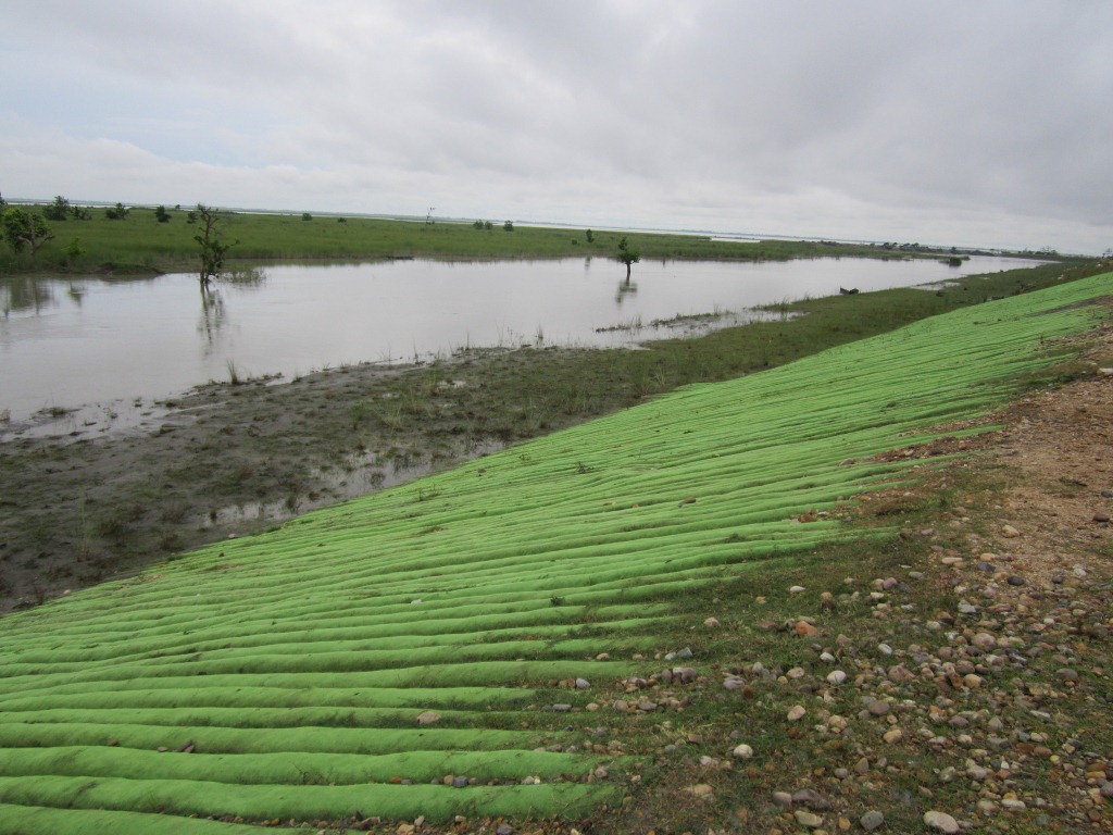
| 4 | Raising & strengthening Dyke from from Sissikalghar to Tekeliphuta including closing of breach by retirement and anti erosion measures | AS | New | B’putra | 142.42 | Accepted |
96th meeting (16.02.2009): Accepted Total – Rs 168.14 crores
| SN | Project | Dist/ State | Appr. year | River/ Basin | Original (revised) Cost-CrRs | Decision |
| 1 | Flood protection of Majuli Island Ph-II & III | AS | New | B’putra | 115.03 | Accepted |
| 2 | Restoration of Dibang & Lohit rivers to their original courses at Dholla Hattiguli | AS | New | B’putra | 23.32(53.11) | Accepted partially & suggested that proposal of coffer dam, pilot channel, etc. may be put up to the Standing Committee for expert opinion |
100th meeting (09.10.2009): Accepted: TOTAL – Rs 897.53 crores
| SN | Project | Dist/ State | Appr. year | River/ Basin | L of Dam | Original (revised) Cost-CrRs | Benefit Irri CCA | Annual Irrigation | Decision |
| 1 | Borolia Irrigation Project | AS | 1980 | Brahmaputra | 92 m | 6.775 (135.93) | 9717 | 15,000 Ha | Deferred due to non-submission of State Finance Concurrence |
| 2 | Khuga Multipurpose (Major- Revised) | Manipur | 1980 | Khuga/ Imphal | 230 m | 15 (381.28) | 9575 | 14,755 Ha | Accepted |
| 3 | Dolaithabi Barrage Project (Med Revised) | Manipur | 1992 | Iril/ Manipur | 79 m | 18.86 (251.52) | 5,500 | 7,545 Ha | |
| 4 | Gumti Irrigation Project (Revised) | Tripura | 1979 | Gumti | 96 m | 5.88 (83.01) | 4,486 | 9,800 ha | Accepted |
| 5 | Khowai Irrigation Project (Revised) | Tripura | 1980 | Khowai | 96 m | 7.10 (83.01) | 4,515 | 9,320 Ha | Accepted |
| 6 | Manu Irrigation Project | Tripura | 1981 | Manu | 82 m | 8.18 (98.71) | 4,198 | 7,600 Ha | Accepted |
101st meeting (30.11.2009): Accepted TOTAL – Rs 1059.26 crores
| SN | Project | State | Appr. year | River/ Basin | L of Dam | Original (revised) Cost-CrRs | Benefit Irri CCA/ flood prot. | Annual Irrigation | Decision |
| 1 | Raising & strengthening to Puthimari embankment | Assam | New | B’putra | NA | 30.23 | 15000 Ha | NA | Accepted |
| 2 | Anti Erosion measures to protect left B’putra Dyke | Assam | New | B’putra | NA | 27.97 | 5000 Ha | NA | Accepted |
| 3 | Protection of Gakhirkhitee and its adjoining areas | Assam | New | B’putra | NA | 19.06 | 20,000 Ha | NA | Accepted |
| 4 | Thoubal Multipurpose Project (revised) | Manipur | 1980 | Thoubal/ Imphal | 1074 m | 47.25 (982) | 21,862 ha | 33,449 Ha | Accepted |
102nd meeting (28.01.2010): Accepted TOTAL – Rs 59.91 crores
| SN | Project | Dist/ State | Appr. year | River/ Basin | Original Cost-CrRs | Benefit-flood protsn | Decision |
| 1 | Emergent measures for protection of Rohmoria in Dibrugarh Dist | Assam | New | Brahmaputra | 59.91 | 18,000 Ha | Accepted |
103rd meeting (11.03.2010): Accepted: TOTAL Cost of approved projects: Rs 302.22 crores
| Project | Dist/ State | Appr. year | River/ Basin | L of Dam | Original (revised) Cost-CrRs | CCA (Ha) | Annual Irrigation (Ha) | Decision |
| Champamati Irrigation Project | Chirag/AS | 1980 | Champamati/B’putra | 258.5 m | 15.32 (309.22) | 17,414 | 24,994 | Accepted |
106th meeting (16.09.2010): Accepted TOTAL – Rs 301.54 crores
| SN | Project | Dist/ State | Appr. year | River/ Basin | Original (revised) Cost-CrRs | Decision |
| 1 | Raising & strengthening of tributary dyke on both banks of Kopili River | Assam | New | Kopilli/ B’putra | 110.72 | Accepted |
| 2 | Assam Integrated Flood River Bank Erosion Risk Management Project | Dibrugarh/ Assam | New | Brahmaputra | 61.33 | Accepted |
| 3 | Assam Integrated Flood River Bank Erosion Risk Management Project | Palasbari/ Assam | New | Brahmaputra | 129.49 | Accepted |
108th meeting (04.01.2011): Accepted TOTAL- Rs 0
| SN | Project | Dist/ State | Appr. year | River/ Basin | Original (revised) Cost-CrRs | Decision |
| 1 | Restoration of Dibang & Lohit rivers to their original courses at Dholla Hattiguli | AS | New | Brahmaputra | 23.32(53.11) | The technical aspect pf this type of project may be looked in to by CWC as per past Practices. |
| 2 | Protection of Majuli Island from flood & erosion, Ph II-III | AS | New | Brahmaputra | 116.02 | The technical aspect pf this type of project may be looked in to by CWC as per past Practices. |
109th meeting (04.03.2011): Accepted TOTAL – Rs 70.13crores
| SN | Project | Dist/ State | Appr. year | River/ Basin | Original (revised) Cost-CrRs | Decision |
| 1 | Anti Erosion & Flood Protection work in Dikrong Basin | Arunachal Pradesh | New | Dikrong | 23.68 | Accepted |
| 2 | Anti Erosion & Flood Protection work in Bhareli sub Basin | Arunachal Pradesh | New | Bhareli | 16.81 | Accepted |
| 3 | Anti Erosion & Flood Protection work in Siyom Basin | Arunachal Pradesh | New | Siyom | 29.64 | Accepted |
110th meeting (20.07.2011): Accepted: TOTAL: Rs 211.56 crores
| Sl No | Project | Dist/State | Appr. year | basin | original cost (Rs. Cr) | decision |
| 1 | Anti Erosion & Flood protection in Tawangchu basin | ArP | New | Tawangchu | 36.47 | Accepted |
| 2 | Protection of Majuli from Flood & Erosion Ph II & III | Assam | 2011 | Brahmaputra | 115.03 | Accepted |
| 3 | Restoration of rivers Dibang and Lohit to their original courses at Dholla Hatighuli | Assam | 2011 | Brahmaputra | 54.43 | Accepted |
| 4 | Protection of Balat village from flood and erosion of river Umngi in W Khasi hill district | West Khasi hill/Meghalaya | New | Brahmaputra | 5.63 | Accepted |
111th meeting (17.08.2011): Accepted: TOTAL: Rs 167.09 crores
| Project | Dist/State | Appr. year | basin | original cost | decision |
| Protection of Biswanath Panpur including areas of upstream Silamari and Far downstream Bhumuraguri to Borgaon | Sonitpur/Assam | New | Brahmaputra | Rs 167.09 Cr | Accepted |
112th meeting (14.09.2011): Accepted: TOTAL: Rs 48.55 crores
| Sl No | Project | Dist/ State | Appr. year | original cost (Rs. Cr) | decision |
| 1 | Improvement of Strom Water Drainage below Greenfield Airport at Pakyong | Sikkim | New | 48.55 | Accepted |
115th meeting (24.07.2012): Accepted: TOTAL: Rs 2208.81 crores
| Sl No | Project | Dist/State | Appr. year | basin | original cost (Rs. Cr) | decision |
| 1 | Thoubal Multipurpose project | Manipur | 1980 | Brahmaputra | 1387.85 | Accepted |
| 2 | Khuga Multipurpose project | Manipur | 1980 | Brahmaputra | 433.91 | Accepted |
| 3 | Dolathabi Barrage Project | Manipur | 1992 | Brahmaputra | 360.05 | Accepted |
| 4 | ERM of Imphal Barrage Project | Manipur | New | Brahmaputra | 16.8 | Accepted |
| 5 | ERM of Sekmai Barrage Project | Manipur | New | Brahmaputra | 10.2 | Accepted |
117th meeting (21.03.2013): Accepted: TOTAL: Rs 155.87 crores
| Sl No | Project | Dist/ State | Appr. year | basin | Ht / L of Dam/Embnk. | original cost (Rs. Cr) | Benefit flood prot. (Ha) | decision |
| Protection of Sissi-Tekeliphuta dyke from erosion – Lotasur to Tekeliphuta | Assam | New | Brahmaputra | 153 km | 155.87 | 10117 | Accepted |
1188h meeting (30.07.2013): Accepted: TOTAL: Rs 467.38 crores
| Sl No | Project | Dist/ State | Appr. year | River/ basin | original cost (Rs. Cr) | Benefit flood prot. (Ha) | decision |
| Flood management of Dikrong and river training works on both banks embankment | Lakhimpur/ Assam | New | Dikrong/ Brahmaputra | 105.96 | 9998 | Accepted | |
| Flood management of Ranganadi and river training works on both bank embankments | Lakhimpur/ Assam | New | Ranganadi/ Brahmaputra | 361.42 | 21056 | Accepted |
119th meeting (29.08.2013): Accepted: TOTAL: Rs 601.67 crores
| Sl No | Project | Dist/ State | Appr. year | River/ basin | original cost (Rs. Cr) | annual irrigation | decision |
| Dhansiri Irrigation project | Assam | 1975 | Dhansiri/ B’putra | 567.05 | Accepted | ||
| ERM of Singda multipurpose project | Manipur | New | Brahmaputra | 34.62 | 3000 | Accepted |
120th meeting (29.08.2013): Accepted: TOTAL: Rs 42.96 crores
| Project | Dist/State | River | original cost (Rs. Cr) | decision |
| Anti erosion work along river Haora from Champakpur to Baldakhal | W Tripura | Haora | 42.96 | Accepted |
121st meeting (08.10.2013): Accepted: TOTAL: Rs 146.01 crores
| Sl No | Project | Dist/ State | River | original cost (Rs. Cr) | Benefit flood prot. (Ha) | decision |
| Anti erosion work along river Gumti from Dlak Samatal Para to Durgapur under Amarpur, Udaipur & Sonamura subdivision | S & West Tripura | Gumti | 54.99 | 2209 | Accepted | |
| Anti erosion work along river Khowaii from Netajinagar to Banglahour under Telimura subdivision and from south L. N. Pur to Paharmura bridge under Khowai subvision | West Tripura | Khowaii | 91.02 | 4256 | Accepted |
122nd meeting (20.12.2013): Accepted: TOTAL: Rs 25.56 crores
| Sl No | Project | Dist/State | River | original cost (Rs. Cr) | decision |
| Loktak Lift Irrigation Project | Manipur | 25.56 | Accepted |
Parag Jyoti Saikia and Himanshu Thakkar
————————————–
[1]While this article only contains the details of the North East India Projects considered in TAC for the five years, we hope to soon provide details of the projects considered by TAC from all over India.
[2] Sicne Khuga Multipurpose, Thoubal Multipurpose and Dolaithabi barrage project, all from Manipur appears twice in this period, they have calculated only for once here.
[3] Feature image – Khuga Mutipurpose project. Image courtesy – http://manipuronline.com/

Lack of Transparency and Accountability Remains the Norm of Functioning for MoWR’s Advisory Committee
The Advisory Committee in the Union Ministry of Water Resources (MoWR) for consideration of techno-economic viability of Irrigation, Flood Control and Multi Purpose Project Proposals (TAC in short) is a very important committee. It accords the financial clearance for any irrigation, flood control and multipurpose project. TAC is supposed to discuss the techno-economic viability of projects as per the resolution published in the Union of India Gazette Notification No. 12/5/86-P-II dated Nov 27, 1987. This committee came into being replacing a similar committee that existed earlier in the planning commission. Even now, the guidelines for functioning of the committee are issued by the Planning Commission.
The Gazette notification cited above also said, “The committee may also invite representatives of any other Government organizations, scientific body of experts in the relevant fields to participate in its deliberations.” This seems like a window to appoint credible, independent, non-government persons in the committee, but this window does not seem to have been used. Among the functions of the committee listed in this notification include, “The functions of the Committee will be to examine projects proposed by State Governments, Central Government or other organizations and satisfy itself that the schemes have been prepared after adequate investigations” and “the need of environment conservation and proper rehabilitation of project-affected persons have been taken into account.” However, our perusal of the functioning of the TAC shows that TAC has failed to fulfill both these mandates.
As noted in the Guidelines for Submission, Appraisal and Clearance of Irrigation and Multipurpose Projects, 2010 available on the CWC website (see: http://www.cwc.nic.in/main/webpages/publications.html), “The project proposal, thereafter, is put up to the Advisory Committee for clearance, which is, by and large, like single window clearance.” The importance of such a single window clearance becomes all the more important. The guidelines further note, “On the basis of examination conducted by the Advisory Committee, decision on techno-economic viability of the projects is taken in the meeting of this Committee. The projects found acceptable by the Advisory Committee shall be recommended for investment clearance by the Planning Commission and inclusion in the Five Year Plan/Annual Plan.” This shows how important is the role of the TAC in judging techno-economic viability of projects and also from the point of view of prudent planning.
No Transparency, independent participation or accountability of TAC Considering the above, there is strong case for clearly defined norms for transparency, participation and accountability in (1) functioning of TAC; (2) The screening process of the projects at initial stages that also happen under these guidelines in the Central Water Commission, based on which approval for DPR preparation is given.
In view of the significance of TAC, this is SANDRP’s third analysis of the decisions taken in TAC meetings. The present analysis covers decisions taken for North East India from 110th to 122nd TAC meeting. In the two previous analysis done by SANDRP, TAC meeting decisions taken from 95th meeting to 109th meeting has been covered. Here it is important to note that lack of transparency has been observed right from the agenda and minutes of the TAC meetings. The agenda and minutes of the TAC meetings should be uploaded on CWC website but CWC website has minutes only till the 115th meeting held on 24th July 2012 and the website has been last updated on 31/08/2012.
In this analysis we have covered 13 TAC meetings held from July 2011 to December 2013. In these 13 meeting, 21 projects from 6 northeastern states have been considered. But out of the 13 meetings held, projects from northeast were considered only in 10 meetings. TAC has accepted the proposals for projects with a total cost of rupees 4075.46 crore. Majority of the projects were given clearance at the first time of consideration. Thus, on an average TAC had cleared projects worth of 407.55 crores from the North East in each of these 10 meetings. Number of the projects considered by TAC in each meeting along with their total cost is given below. A state-wise and a project-wise list is also provided.
Total Cost of Projects Cleared by TAC July 2012 to December 2013
| Sl No | Meeting no | Date of meeting | No of projects considered from NE | No projects approved | No of projects deferred | No of projects rejected | Total cost of the accepted projects, Rs Crore |
| 1 | 110th | 20-07-11 | 5 | 4 | 1 | 0 | 211.56 |
| 2 | 111th | 17-08-11 | 1 | 1 | 0 | 0 | 167.09 |
| 3 | 112th | 14-09-11 | 1 | 1 | 0 | 0 | 48.55 |
| 4 | 115th | 24-07-12 | 5 | 5 | 0 | 0 | 2208.81 |
| 5 | 117th | 21-03-13 | 1 | 1 | 0 | 0 | 155.87 |
| 6 | 118th | 30-07-13 | 2 | 2 | 0 | 0 | 467.38 |
| 7 | 119th | 29-08-13 | 2 | 2 | 0 | 0 | 601.67 |
| 8 | 120th | 13-09-13 | 1 | 1 | 0 | 0 | 42.96 |
| 9 | 121st | 08-10-13 | 2 | 2 | 0 | 0 | 146.01 |
| 10 | 122nd | 20-12-13 | 1 | 1 | 0 | 0 | 25.56 |
| Total | 20 | 4075.46 |
State-wise list of projects cleared by TAC
| Sl. No | State | No of projects approved | Total cost of the approved projects, Rs Crore |
| 1 | Arunachal | 1 | 36.47 |
| 2 | Assam | 7 | 1526.85 |
| 3 | Manipur | 7 | 2268.99 |
| 4 | Meghalaya | 1 | 5.63 |
| 5 | Sikkim | 1 | 48.55 |
| 6 | Tripura | 3 | 188.97 |
Note: No projects from Mizoram and Nagaland have come to TAC in this 30 month period.
Some observations regarding TAC meetings
1. Zero Rejections The TAC did not reject a single project. There was only one project which was deferred in the 110th meeting but it was approved in the next meeting. Rest of the new projects were were approved in the very first meeting of their consideration.
2. Lack of information The TAC minutes provide little information about projects. Specially in case of newer projects, detailed discussions should have happened. The minutes of TAC meetings do not give much of an idea about size, location, benefits of a particular project. In the project- wise list provided towards the end of this analysis, we have provided limited information available in the minutes. Some of the noteworthy missing information is listed below:
– In the 115th meeting, 5 projects from Manipur were considered. Out of these five projects, 2 were multipurpose projects and 3 were barrage projects. Surprisingly, there was no information about where these projects are located, on which river, what the size of these projects. None of the minutes mentioned about whom these projects will actually benefit. Only two projects mentioned about increase in annually irrigated land but no more detail was provided.
– In the 118th meeting, construction of embankments on both banks of river Ranganadi for flood management and river training was considered. But the cost of the project was on the higher side compared to the embankment construction work to be done on the river Dikrong, considered in the same meeting. This cost escalation may be due to the difference in the length of the projects. But this cannot be confirmed since minutes do not mention the length of the proposed embankments.
But the increased costs may also be due to the use of Geo bag technology for construction of Ranganadi embankments. Use of Geo-bag technology is a costly affair but nothing has been mentioned about the use of this technology in the minutes of 118th meeting. This is stated in the annexure (Annex VI as mentioned in the document) of the meeting. Interestingly this annexure too has been mentioned only as a corrigendum.
3. No Detailed Discussion on Projects Considered This was very evident in the two previous analysis done by SANDRP and situation remains the same this time as well. In case of all the projects, including the ones considered for the first time, there was no detailed information or any detailed discussion. There is no discussion on technical viability of the project. Reading through the minutes gives an impression that approval for any project considered by TAC is fait accompli. There is no discussion about whether the project is a desirable project, if there are other options available, if this is the best option and so on. Under the mandate given to it, TAC is supposed to discuss all these issues. TAC accepted projects proposals with huge cost and time overruns but little enquiry has been made why such escalation happened.
Dhansiri irrigation project This is a glaring example of cost escalation. The project was discussed in the 119th meeting on 29.08.2013 for consideration of cost of Rs 567.05 crores. But, it was surprising to find that original cost of the project in 1975 was Rs 15.83 crores as according to the information available in Assam State Irrigation Department website.[1] The same website states that project started in 1975 and supposed to be completed 35 years later in 2010. In the TAC meeting a new time schedule of March 2015 was stated. The cost of the project has increased by 35.82 times over a period of 40 years but the advisory committee accepts proposal without much scrutiny or enquiry. There was no detailed assessment of the reasons for time and cost over runs (there is no question of delay due to clearances or agitations here) or whether this project which will take 40 years just to complete will be viable or not. On the contrary, the planning commission representatives said, “the benefit cost ratio of the project was 1.2 and any further escalation in cost would result in the project becoming techno-economic unviable.”
The TAC should have done a detailed assessment why the project took so long time to complete. But it seemed to be contended with the rational that the project authorities provided which was that due land acquisition and law and order problem the project has not been completed. But in the meantime minutes of the meeting also showed that that major components of the project are in advanced stages of construction with 93% of barrage work, 99% of the canal works and about 83% of works in the distribution system were reported to have been completed. There has been no detailed assessment in to any of these aspects.
Imphal Barrage project In this project, the cost of the project mentioned in the minutes of the 115th meeting contradicted with the cost provided in the annexure. The cost of Extension, Renovation and Modernization (ERM) of the Imphal barrage project as mentioned in the minutes is Rs 16.80 crores. But a letter from the Under Secretary, Govt. of Manipur to the Chief Engineer of Irrigation and Flood Control Department, Manipur dated 21.07.2012 stated the cost of the project as 23.41 crores. This reflects the lack of serious discussion over projects in TAC. It is also surprising that TAC, being the committee which gives the techno economic clearance to projects, does not have clarity about even the cost of the project.
4. No Discussion over Social, Environmental and Other impacts of the Projects The projects cleared by TAC have serious social, environmental and other impacts but the committee never discussed these impacts. TAC does not at all take into account the impacts a project would have on the environment.
In the 118th meeting (30.07.2013), while considering the proposal for flood management of Dikrong along with river training works on both banks, the minutes stated “Effectiveness of existing embankments of river Dikrong has been deteriorating due to lack of repair, siltation of river bed and consequential change in river behaviour, change in flow pattern due to release of Ranga Nadi hydel project etc.” But this is one of the rare instances when TAC mentioned about the environmental impacts on embankments. But rather than asking for more details on these impacts or to see whether embankment would really be a viable option or not, the TAC accepted the proposal. On the other hand nowhere the committee discussed what impacts an embankment has on river bed, siltation or downstream stretches of a river.
It is also important to note here TAC also does not take into consideration impacts of the hydropower projects on the embankments in the downstream of the river. In the above mentioned case, the increased costs of Dikrong embankment should have been charged on the Ranga Nadi HEP, but there is no discussion on this. The Pare hydropower project (110 MW) in Papumpare district of Arunachal Pradesh is currently under construction on Dikong / PareRiver. Moreover there are at least 10 hydropower projects at various stages in the combined Ranganadi-Dikrong basin in Arunachal Pradesh, including one operating, three TOR approvals given and five additional MoA signed (in addition to a proposed project). There is no provision to assess the impacts of these projects on the embankments downstream of DikrongRiver in Assam. In fact there is no provision for any impact assessment study for embankments even though studies show the disastrous impacts of embankments on environment, floods and on the lives of the people living close to the river.
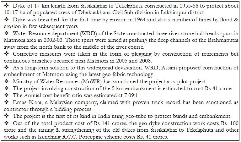
5. Clearing Same Embankment Projects over Years In terms of embankments, it is observed that the TAC had cleared same projects over the years. Not emphasizing on the environmental impacts of embankment projects is one of the major reasons for this. In the 117th TAC meeting held on 21.03.2013 the proposal for “Protection of Brahmaputra dyke from Sissikalghar to Tekeliphuta at different reaches from Lotasur to Tekeliphuta from the erosion of river Brahmaputra Assam” was considered. The estimated cost of the project was Rs 155.87 crore. But on the same embankment, a project titled “Raising and Strengthening to Brahmaputra dyke from Sissikalghar to Tekeliphuta including closing of breach by retirement and anti-erosion measures (to protect Majuli and Dhakukhana areas against flood devastation by the Brahmaputra, Lakhimpur district, Assam) was accepted in the 95th TAC meeting held on 20.01.2009. The estimated cost of the earlier project was 142.42 crore.
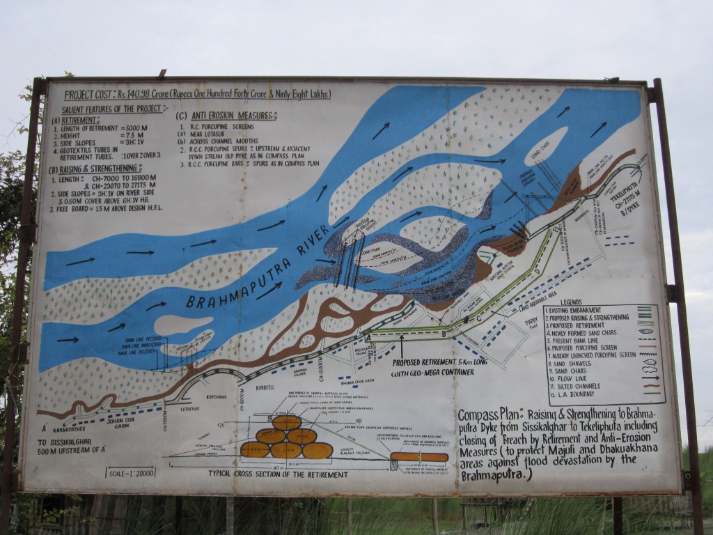
Photo: Parag Jyoti Saikia
The minutes of the 117th meeting, about the previous scheme said that it “was taken up primarily for closure of breach in the then existing embankment including raising of embankment around the breach area only.” But the minutes of the 95th TAC meeting had said something totally different about the project. The minutes stated that project proposal envisaged – (i) Raising and strengthening of embankment for a length of 13.9 km, (ii) Construction of retirement bund with geo-textile tubes of length 5000 m. This shows how the discussion on the Brahmaputra dyke Sissikalghar to Tekeliphuta is 117th meeting is completely misleading. TAC does on even take into account its previous meeting discussions before clearing a project. This possibly gives a hint of a scam.
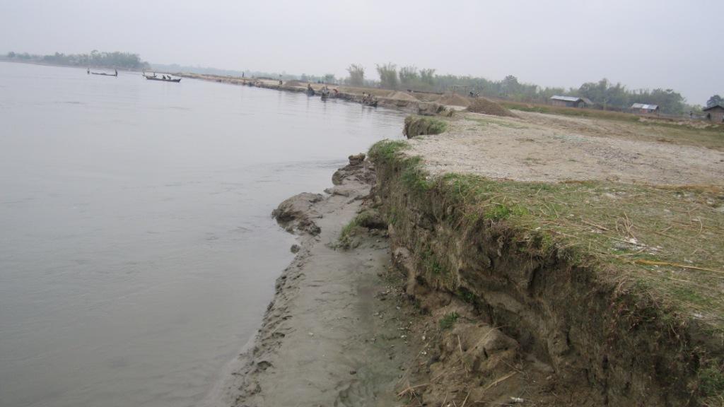
The Brahmaputra dyke from Sissikalghar to Tekeliphuta has a long history of facing severe erosions. The first geo-tube embankment was constructed on this dyke in Dec 2010. Crores have been spent for the protection of this embankment. But even after that the Dhakukhana sub-division always remained in the headlines during the flood season in Assam. There is need for area specific detailed study assessing the impact on and of the embankment, but little has been done in this regard. Besides, the Bogibeel Bridge, the fourth one on the BrahmaputraRiver, is coming up in the upstream of this embankment. Construction of this bridge would make this dyke even more prone to erosion since the length of this bridge will be 4.94 km, shrinking the wide river to great extent. In a personal visit to the area, one of the government officials informed that as a result of this “funneling action”, the force of water will increase and it will directly hit the embankment leading to more erosion. But TAC has never dealt with these issues in its meetings but cleared all the proposals that it considered.
Short History Brahmaputra Dyke from Sissikalghae to Tekeliphuta[2]
6. There is no independent, critical voice in the meetings. The agenda, proceedings, or decisions of the meetings are not even in public domain.
7. There is no mechanism to hold the TAC accountable for any wrong decisions taken.
8. The TAC is clearly not fulfilling the mandate given to it in the guidelines for TAC meetings. The guidelines themselves need revision from several points.
9. There is no attempt to assess the justifiability of the kinds of projects that are being accepted and if they are indeed delivering the promised benefits.
Parag Jyoti Saikia (meandering1800@gmail.com)
Project-wise Detailed List of TAC decisions
110th meeting (20.07.2011): Accepted: TOTAL: Rs 211.56 crores
| Sl No | Project | Dist/State | Appr. year | basin | original cost (Rs. Cr) | decision |
| 1 | Anti Erosion & Flood protection work | Arunachal Pradesh | New | Tawangchu | 36.47 | Accepted |
| 2 | Protection of Majuli from Flood and Erosion Phase II & III | Assam | 2011 | Brahmaputra | 115.03 | Accepted |
| 3 | Restoration fo rivers Dibang and Lohit to their original courses at Dholla Hatighuli | Assam | 2011 | Brahmaputra | 54.43 | Accepted |
| 4 | Protection of Balat village from flood and erosion of river Umngi in West Khasi hill district | West Khasi hill/Meghalaya | New | Brahmaputra | 5.63 | Accepted |
111th meeting (17.08.2011): Accepted: TOTAL: Rs 167.09 crores
| Sl No | Project | Dist/State | Appr. year | basin | original cost (Rs. Cr) | decision |
| 1 | Protection of Biswanath Panpur including areas of upstream Silamari and Far downstream Bhumuraguri to Borgaon against erosion of the river Brahmaputra | Sonitpur/Assam | New | Brahmaputra | 167.09 | Accepted |
112th meeting (14.09.2011): Accepted: TOTAL: Rs 48.55 crores
| Sl No | Project | Dist/ State | Appr. year | original cost (Rs. Cr) | decision |
| 1 | Improvement of Strom Water Drainage below GreenfieldAirport at Pakyong | Sikkim | New | 48.55 | Accepted |
115th meeting (24.07.2012): Accepted: TOTAL: Rs 2208.81 crores
| Sl No | Project | Dist/State | Appr. year | basin | original cost (Rs. Cr) | decision |
| 1 | Thoubal Multipurpose project | Manipur | 1980 | Brahmaputra | 1387.85 | Accepted |
| 2 | Khuga Multipurpose project | Manipur | 1980 | Brahmaputra | 433.91 | Accepted |
| 3 | Dolathabi Barrage Project | Manipur | 1992 | Brahmaputra | 360.05 | Accepted |
| 4 | ERM of Imphal Barrage Project | Manipur | New | Brahmaputra | 16.8 | Accepted |
| 5 | ERM of Sekmai Barrage Project | Manipur | New | Brahmaputra | 10.2 | Accepted |
117th meeting (21.03.2013): Accepted: TOTAL: Rs 623.25 crores
| Sl No | Project | Dist/ State | Appr. year | basin | Ht / L of Dam/Embnk. | original cost (Rs. Cr) | Benefit flood prot. (Ha) | decision |
| 1 | Protecion of Sissi-Tekeliphuta dyke from erosion – Lotasur to Tekeliphuta | Assam | New | Brahmaputra | 153 km | 155.87 | 10117 | Accepted |
1188h meeting (30.07.2013): Accepted: TOTAL: Rs 623.25 crores
| Sl No | Project | Dist/ State | Appr. year | River/ basin | original cost (Rs. Cr) | Benefit flood prot. (Ha) | decision |
| 1 | Flood management of Dikrong and river training works on both banks embankment | Lakhimpur/ Assam | New | Dikrong/ Brahmaputra | 105.96 | 9998 | Accepted |
| 2 | Flood management of Ranganadi and river training works on both bank embankments | Lakhimpur/ Assam | New | Ranganadi/ Brahmaputra | 361.42 | 21056 | Accepted |
119th meeting (29.08.2013): Accepted: TOTAL: Rs 601.67 crores
| Sl No | Project | Dist/ State | Appr. year | River/ basin | original cost (Rs. Cr) | annual irrigation | decision |
| 1 | Dhansiri Irrigation project | Assam | 1975 | Dhansiri/ B’putra | 567.05 | Accepted | |
| 2 | ERM of Singda multipurpose project | Manipur | New | Brahmaputra | 34.62 | 3000 | Accepted |
120th meeting (29.08.2013): Accepted: TOTAL: Rs 42.96 crores
| Sl No | Project | Dist/State | River | original cost (Rs. Cr) | decision |
| 1 | Anti erosion work along river Haora from Champakpur to Baldakhal | West Tripura | Haora | 42.96 | Accepted |
121st meeting (08.10.2013): Accepted: TOTAL: Rs 146.01 crores
| Sl No | Project | Dist/ State | River | original cost (Rs. Cr) | Benefit flood prot. (Ha) | decision |
| 1 | Anti erosion work along river Gumti from Dlak Samatal Para to Durgapur under Amarpur, Udaipur & Sonamura subdivision | S & West Tripura | Gumti | 54.99 | 2209 | Accepted |
| 2 | Anti erosion work along river Khowaii from Netajinagar to Banglahour under Telimura subdivision and from south L. N. Pur to Paharmura bridge under Khowai subvision | West Tripura | Khowaii | 91.02 | 4256 | Accepted |
122nd meeting (20.12.2013): Accepted: TOTAL: Rs 25.56 crores
| Sl No | Project | Dist/State | River | original cost (Rs. Cr) | decision |
| 1 | Loktak Lift Irrigation Project | Manipur | 25.56 | Accepted |
[2] From the brochure published by WRD, Assam at the time of commissioning the geo-tube embankment in Matmora

Dam’ned: A Film on Polavaram Dam Give Voice to the Unheard
At a time when the creation of separate Telengana state from Andhra Pradesh is making headlines in the national media, the issue Polavaram dam seems to have been sidelined in media. But Polavaram dam holds huge significance in this situation since construction of this dam is one of the condition laid down by the center in order to create state of Telengana bifurcating the state of Andhra Pradesh. The dam though has no legally tenable clearance, Odisha and Chhattisgarh continue to oppose it and there are cases pending against the project in the Supreme Court.

Now a 2013 film by social activist and filmmaker Saraswati Kavula “Dam’ned” documents plight of the people being affected by the Polavaram dam. The film also brings out the critical issues associated with the construction of this mega dam which were rarely covered by any media. The film is available in four parts on youtube, see: http://www.youtube.com/channel/UCb4JjIYab5w_dFkHwkmkrHQ?feature=g-user-u.
The 71 minutes film is a brilliant documentation of peoples sentiments associated with the river, land and a project which will submerge all of these. Within these 71 minutes the film brings to light the multitude and complexity of issues associated with this mega project. But before getting into that, a brief about this gigantic project has been provided, as given in the film.
The Polavaram Project Polavaram is one of the most controversial dam projects in India. It is also the largest dam in India in terms of the number of people it would displace. The dam will be located near Polavaram village in West Godavari district of Andhra Pradesh, an area bordering Chhattisgarh and Odisha. The dam aims to irrigate 7,21,000 acres of land in four districts of Andhra Pradesh i.e. West Godavari, East Godavari, Vishakhapatnam and Krishna districts. The project proponent claims that this project will also provide drinking water to 540 villages of Vishakhapatnam district along with the city of Vizag and to provide water to industries located in Vishakhapatnam district. The project also aims to transfer 80 TMC (Thousand Million Cubic Feet) water from Godavari to Krishna river basin.
The cost of mega plan will be majorly born by the ethnic tribal people of Andhra as well Chhattisgarh and Odisha. The dam will submerge 300 villages displacing 2,00,000 people. The submergence area will be so huge that the back waters of the dam go all upto Sabari river in Chattisgarh and Sileru river in Odisha. This submergence area will cover 10,000 acres of biodiversity rich forest and also partially submerge the Papikundulum wildlife sanctuary. The people living in these areas are predominantly ‘adivasis’ belonging to Koya and Konda Reddy tribes. There is a substantial number of no-tribal people, majority of the belonging to Dalits and backward classes. In numbers nearly 200 out of the 300 submerged villages are adivasi villages.
Why this Film is Important The film is threaded around people’s strong links with the land, forest, biodiversity and river. Throughout the film how people have associated themselves with the natural resources and how breaking this association is inviting havoc for the economic conditions and social relations have been depicted brilliantly.
“This is a land where our ancestors have been living for ages and we won’t leave it at any cost” such sentiments have been echoed throughout the history in most cases of displacement caused due to dams or any other project displacing people. This film on Polavaram documents with videos why and how this is such a crucial case against such projects. The film shows how displacing people from one place and giving them compensation either in terms of money or in rare cases some land has done little to improve the conditions of the people and has in fact impoverished and disempowered the people. This, as the film very clearly shows, has thrown them in to a life of poverty and uncertainty.
The film is packed with interviews of the people affected by the dam either due to submergence or due to other project components like canal construction. The filmmaker also interviewed experts from the field to show how the construction of Polavaram dam violates legal norms, is technically not feasible and takes no lesson from the experiences of construction of similar project in other parts of the country and how better options exist.
The personal interviews done brings to light how the people have little information about the project in Andhra Pradesh and have literally no information in Chhattisgarh and Odisha. In Andhra Pradesh, the government is also building infrastructure such as roads and buildings in areas which have been identified as submergence areas. This rather than helping people is creating confusions. There has been no environment or social impact assessment or public consultations in Chhattisgarh or Odisha, nor any plans for rehabilitation or environmental management. The Polavaram project got environment clearance in Oct 2005 but till 2013, in Andhra Pradesh out of the 276 submergence villages only 30 to 40 villages have been receiving compensation and that too only partly for their land only.
Complexities with Compensation: Monetary The film also brings out what is actually happening with the money given as compensation. The compensation that was given to one affected family, loosing 1.5 acres of land, was Rs. 1,68,000. When asked what did they do with the money, the head of the family said that they distributed the money among the family members where each person got around Rs. 10,000. People from Khammam district narrated the story of how they have been looted in the process of getting the compensation cheques from the government officials and lawyers. People were also cheated by insurance companies which came to these areas in large numbers posing as banks after people received their cheques. People also believed that after the project compensation was given the social relations in villages have deteriorated. One of the ladies from an affected family said “Many people died since the money came… drinking heavily and died… People are fighting among themselves since the money came.” 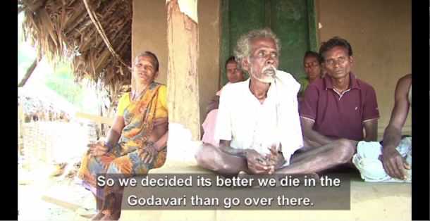
The Bone of Contention: Land The film shows that even in case of the compensation received in the form of land, why the result is equally distressful. In a rehabilitation colony in East Godavari district few males are to be found since they have migrated to the cities to find work. People said that there is no farmland for them to work nor there is any work under MGNREGA. In Kuruturu in West Godavari district, the conflict over land between tribal and non-tribal people have intensified since displaced people were given disputed land as part of their rehabilitation plan. Many people who were given such land returned to their original villages due to these conflicts. They now conclude: “we have decided that its better we die in the Godavari, rather then go over there.” Some of the affected people (e.g. in Kunta block in Dantewada district of Chhattisgarh) face double displacement. The people of this area were forced to shift to Salwa Judum camps due to the conflict between Maoist and Salwa Judum since 2005. But at a time when they were returning to their villages to resume their lives, they were told that they will again had to leave their villages as they will be submerged by the Polavaram dam.
Canals Completed without any work on the Dam The film also throws light on drawback of the construction plan of the Polavaram dam. The films shows that the construction work of the irrigation canals of the project is almost complete at a time when no progress has been made in the construction of the main dam. This project, as Himanshu Thakkar of SANDRP points out in the film, resembles the Rs 75,000 crore Maharastra irrigation scam where canals were constructed to fulfill the interests of the construction lobby without doing any work on the main dam. The massive Andhra Irrigation Scam is only beginning to surface, as pointed out in a recent CAG report[i].
Embankments as Huge as ‘China Walls’ The film shows that the proposal to construct embankments as huge as the ‘China wall’ on Sabari and Sileru rivers of Chhattisgarh and Odisha to prevent submergence of the areas in these states can only be possible on paper. The plan to construct embankment came as response to Orissa High Court order which said that Polavram project cannot submerge the areas of Odisha and Chhattisgarh. However, embankments were not a part of the original construction plan which received clearance from Environment Ministry. Nor has there been any environment or social impact assessment or feasibility study based on ground realities of the embankment proposal. There has also been no public consultations in these affected areas.
Experts say construction of such embankments would be a huge blunder of the Polavaram project. In the film Prof. T. Shivaji Rao of Center of Environment Studies in GITAM Univeristy, Vizag opined that with embankments there will be greater damage for Odisha and Chhattisgarh. Andhra Pradesh has also made a plan to put 16 lifts at different points on the embankments on Sabari and Sileru rivers to lift the water from the tributaries to the main river during flooding season. During rains these lifts are to lift and pump the water over the embankment walls and pour it in the river. This is doomed right from the beginning. The film shows this by bringing a detailed account of the experience of similar sluice gate scheme on the Godavari embankment in Bhadrachalam where it failed miserably. The sluices got closed up leading to waterlogging and inundation of houses.
There is no doubt that this film is a very detailed documentation of the issues related with Polavaram dam. The filmmaker could have added some voices from the government or project authorities to give a complete picture. In the film serious concerns were raised against how the government has handled the whole issue of Polavaram. I would recommend all concerned must watch this film. For a copy, either see the youtube link given above or write to the film maker: skavula09@gmail.com, the price of a copy of the film is Rs 350/- including postage charges of Rs 50/-. Do watch and spread the word!
Parag Jyoti Saikia
Shoddy EIA by WAPCOS Tries to Push Unjustifiable Bansujara Irrigation Project in Madhya Pradesh
The EIA of the Bansujara Multipurpose Project (BMP) dated May 2013 by WAPCOS has been submitted for Environment Clearance of the project before the Expert Appraisal Committee on River Valley Projects, in Nov 2013. WAPCOS is known to do very shoddy job of Environment Impact Assessments, this one is no different. In what follows I have given a few instances of wrong facts, contradictory facts, wrong calculations or assumptions, incomplete assessments, instances that shows it is cut and paste job and lack of options assessment by the 564 page EIA document. The conclusion is inescapable that the EAC and MoEF must reject this EIA and recommend black listing and other measures against WAPCOS. The project should be asked to get a fresh EIA done by a credible agency.

WRONG FACTS The EIA provides several completely wrong facts, here are a few instances:
1. River description On p 1-1 the EIA says: “The Bansujara Dam Project lies in Dhasan sub-basin of Betwa basin, River Betwa is a tributary of Yamuna river, rises in district Bhopal district at an elevation of 472 m. After traversing a length of 365 km, it joins Yamuna river in Uttar Pradesh. The river runs for nearly 240 km in Madhya Pradesh, 54 km along common border of Madhya Pradesh and Uttar Pradesh and 71 Km in Uttar Pradesh state before its confluence with Yamuna river near Hamirpur town in Hamirpur district of Uttar Pradesh.” This is actually the description of River Dhasan and not Betwa! It is exactly same as the description of river Dhasan given on the next page and several other places subsequently.
2. Land required for Canals In Table 2.3 it is stated that canals will require 44 ha land, this is clearly gross under-estimate considering even 49.9 km of main canal.
3. Private land under required for project The SIA says on page 1-2, “About 935.11 ha of culturable area, 57.49 ha of forest land and 4209.118 ha of other land including road, nallah, river, etc. will be affected.” This is blatantly wrong figure. On page 1-3/4 of SIA it is stated: “About 2935.11 ha of revenue/government land and 2894.37 ha of private land is to be acquired.” This again is wrong.
As the MoEF factsheet for the Forest clearance for the project says, “Apart from the 57.495 hectares of forest land proposed to be diverted, the project involves submergence of 287.951 hectares of government land and 4,856.276 hectares of private land.” Thus the suggestion by the SIA that only 935.11 ha of culturable land is going under submergence is clearly wrong since most of the private land is under cultivation in these villages.
4. How many families will be affected The MoEF Factsheet for the project says: “The project involves submergence of 21 villages. 2628 houses, 773 wells, 5082 trees, and 2628 families with population of 13,142 are getting affected due to submergence.” These figures are at variance with the figures mentioned in the EIA. For example, the SIA (p 1-4, repeated on page 4-1) says: “Over all 748 families of 9 Abadi Villages will be affected”. This when the project will be taking away 2628 houses as per the Fact sheet, is clearly gross wrong reporting of figures. Because of use of wrong figures, their R&R plan and R&R costs are also all wrong and gross under estimates. Moreover, now the R&R plan and costs should be as per the new Land Acquisition Act Passed by the Parliament, which has not been done in the EIA-SIA. As per the new Act, land has to be provided to each losing farmer, and this must be followed.
5. Completely impossible figures of crop yields A look at table 4.3 of SIA (repeated in table 7.1 of CADP) shows that the consultants have given crop yields before project (e.g. paddy 7 t/ha, wheat 18 t/ha, groundnut 10 t/ha and gram 10 t/ha) which are much higher than the average of even Punjab crop yields and they are expecting to double that post project! These are clearly impossible figures. This shows that the consultants are plain bluffing and seem to have no clue about possible crop yields and in any case do not seem to have done any surveys, but are only cooking up data. Amazingly, they are claiming that with 211% increase in crop yield, the profits from crops will go up by 318%! All this simply shows the manipulations they are indulging in to show the project is economically viable.
CONTRADICTORY FACTS
1. Main canal length Page 2-2 says main canal length is 90 km, the salient features on next page says Main canal length is 49.9 km.
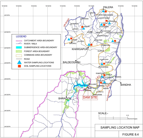
2. Command area Tehsils and villages Section 10.2 of EIA (and again section 2.7 of the CADP) says: “The Command area of the proposed Bansujara Major Irrigation project lies within the district Tikamgarh in jatur and Baldeogarh tehsil” and than goes on to give details of these tehsils, but the rest of the document (e.g. section 6.1) says: “A total of 124 villages are likely to be benefitted by the project. 80 villages are located in Tehsil Khargapur of district Tikamgarh. About 13 villages are located in tehsil Jatara of district Tikamgarh. The remaining (31) villages are located in tehsil Palera of Chattarpur district.” Chapter 6 in fact provides full list of 124 villages in the command area. The subsequent details of the command area given in chapter 10 thus does not match with what is given say in chapter 6.
Contradicting this, page 1-4 of SIA says: “The Bansujara Multipurpose Project will benefit almost 132 villages in districts Tikamgarh and Chattarpur.” Amazingly, the SIA says Palera tehsil is in Tikamgarh district and not in Chattarpur district and that additional ten villages of Badamalhera tehsil of Chattarpur district will also be in command area!
Number of beneficiary villages in Palera tehsil are given as 31 in page 44 (chapter 6) and 30 on page 141 (chapter 11), with even names differing, e.g. Banne Khurd and Bastaguwan mentioned in chapter 6 are missing in chapter 11, village Bargram mentioned in chapter 11 is missing from the list in chapter 6.
All this is most callous and shocking. This fact alone should be sufficient to REJECT this callous EIA and recommend blacklisting and other punitive measures for WAPCOS as consultant.
3. Command area population Section 10.2.1 of EIA says: “As per 2001 Census the total population of the command area is about 38,000. The male and female population is 20,181 and 17,828”. However a look at the 10.2 that follows this sentence shows that these figures are for Jatara tehsil and not command area. Another sign of callousness.
4. Submergence villages Table 11.3 of EIA gives list of Project affected families, which is at variance with the list given in tables 10.8-10.14. Firstly, chapter 10 tables say that 14 villages of Tikamgarh Tehsil are affected, but table 11.3 lists only 13 villages. More shockingly, tables in chapter 10 say 6 villages of Bada Malhera tehsil of Chhatarpur district are affected, whereas the name of this tehsil given in chapter 11 is Bijawar. All this shows shocking callousness of WAPCOS.
5. Storage Capacity Page 11-10 says: “The storage capacity of Bansujara Reservoir is 539.42 Mm3.” This is clearly wrong, the figures for gross and live storage capacity given in salient features and elsewhere are: 313.1 MCM and 272.789 MCM respectively.
6. Water Availability As per Table 5.8, water availability at the project site from MP catchment (2788 sq km) alone is 843 MCM. Strangely, this reduces to 588.68 MCM in table 11.6 for whole of catchment (3331.776 sq km) at dam site. No explanation is given for these figures.
7. Submergence area While most of the document gives submergence area as 5201.71 ha. However, in section 2.7 of EMP, it says, “The submergence area of Bansujara Irrigation Project is 7476 ha.” This is amazing kind of contradiction.
WRONG CALCULATIONS/ ASSUMPTIONS
1. Field channel length grossly underestimated The p 6-6 of EIA says: “The Bansujara Dam Project envisages irrigation over a CCA of 54000 ha. In the areas where irrigation is proposed no field drainage, land shaping of field channels exist and used to be constructed. From general experience and existing practice, it is assessed that a length of 1600 m of field channels will be required to serve a chak of 40 ha of CCA. On this basis, an approximate network of total length of 180 km of field channels will be required for 50% of CCA proposed for irrigation.” Simple calculation suggests that the field channel length for 50% of CCA would be 1080 km (54000 ha / 40 ha per 1.6 km divided by 2 for 50% CCA).
2. Drainage requirement under estimated Section 6.9 (p 6-7) of EIA says, “The command area is being traversed by a large number of nallahs and drains, therefore field drainage should not pose any problem.” This is clearly wrong assumption since additional irrigation will certainly require additional drainage and cost calculations based on such flawed assumptions are bound to be wrong.
3. Baseless assumption about waterlogging Similarly about the assumption in section 6.13 (p 6-8): “Even after construction of Bansujara Dam Project the area will not face any waterlogging problem.”
4. Wrong claims about no floods The conclusion about flood and back water impacts is completely unfounded in section 6.14 (p 6-8): “As per information gathered from the Collectorate Tikamgarh there is no village affected due to back-water of Dhasan and Ur rivers. The existing drainage system in the command is adequate. The statistics gathered from collectorate Tikamgarh show that there is no flood affected area. The command has fairly good flood disposal capacity and not special measures are called for.” This when the Maximum water level of the dam is full 1.4 m above the FRL, the back water level is found to be high. This is also particularly relevant in flood prone basin like Betwa-Dhasan.
5. Drainage characteristics of clayey soils ignored The assumption in section 7.1 (p 7-1) shows complete lack of understanding on the part of EIA consultants: “The area is sloping gently and near its outfall into Betwa river, the slope is of the order of 0% to 3%. It is traversed by small drainage channels at short distances and they help in draining excess water efficiently. Hence, no provision for drainage has been made. The soil is generally clayey.” It is well known that clayey soils are inefficiently draining soils and to make such assumption for clayey soils is clearly wrong.
6. Unrealistic assumption of irrigation efficiency System irrigation efficiency of 54% assumed in Table 11.10 is clearly wrong, no project in India has achieved such high efficiency. The water loss will surely be much higher than the assumption of 105 MCM on page 11-14. The conclusion on that page that: “The quantum of water not being utilized is quite small and is not expected to cause any significant problem of waterlogging” is clearly wrong and baseless, since water logging also depends on many other factors including drainage, soil structure, underground geology, among other factors.
7. No industries, but 19.4 MCM for industries! The CADP (page 5-7) clearly states: “At present there is no industrial requirement in the area.” And yet the project allocates 19.4 MCM water for industries. This again shows that the project is being pushed even though there is no need for it.
INCOMPLETE ASSESSMENT
1. Dependence on fisheries incomplete It is not clear what is the area from which fisheries assessment done as reported in section 9.11.6. How many people depend on fish, what is the production market and economy of the same is also not reported.
2. Hydrology figures without basis Chapter 11 (Table 11.6) assumes that “For use on u/s of Bansujara dam for environmental and ecological balance and Misc. uses by surface water” is 10 MCM and “Quantity of water reserve for d/s release for environmental and ecological balance” is 15.18 MCM and that groundwater available upstream of dam site will be 58.86 MCM (10% of surface water). No basis is given for any of these and all these (and many other) figures given in the water balance are clearly ad hoc, unfounded assumptions. The groundwater availability is typically 40% of total water availability, so around 67% of surface water availability. Why should it be 10% in case of the Dhasan basin is not explained and in any case does not seem plausible.
However, in Table 2.2 of EMP, the environment flow suggested in monsoon months is 12.8 cumecs. This would mean that the project would need to release 132 MCM of water in four monsoon months as environment flows, when they have assumed in hydrology that only 15.18 MCM water is required for this!
3. Incomplete SIA SIA says (SIA page 1-7) that it has selected certain of the 21 villages facing submergence due to the project. Actually the SIA should have done full survey of all the villages not a sample of villages.
4. Impact of loss of river not assessed It is expected that the SIA will assess the impact of loss of river for the people in submergence and downstream zone, but no such assessment has been done. Even in section 4.4 of SIA on “Impacts of Socio-Cultural Environment”, there is no mention of impact of river (or forest or other natural resources) on the people.
5. Full Canal details not given The EIA or CADP report does not provide the full lengths of main canals, distributaries, minors, field channels and field drains, including their width, land requirements, protection measures like canal like plantations etc. Without these basic details, the EIA or the CADP cannot be considered complete.
6. Command area coinciding with command area of Ken Betwa Link canal and other such projects? A perusal of the Command area of the Ken Betwa River Link Project (TOR approved by EAC in its 45th meeting in Dec 2010) shows that all the three Tehsils (namely Baldeogarh or Khargapur in Tikamgarh district, Jatara Tehsil in Tikamgarh district and Palera Tehsil in Chhattapur district) are also benefiting from Ken Betwa Link Canal. A look at the map of the command area of Ken Betwa link canal and that of the Bansujara shows that some area are certainly common. The EIA of Bansujara should have pointed this out and also if the proposed command area is to benefit from any other such projects, but it has not done that.
CUT AND PASTE JOB? Several parts of EIA raises the suspicion that they are cut and paste from other documents. This suspicion is proved correct when we see this sentence in Table 12.2 in Disaster Management Plan (Chapter 12 of EMP): “All staff from dam site, power house & TRC outlets alerted to move to safer places”, since the Bansujara project has no power house or TRC (Tail Race Channel). The consultants forgot to remove these irrelevant aspects while doing the cut and past job[1], it seems. This is just by way of illustration.
Similarly, the title of the section 2.6 of the Command Area Development Plan says it all: “2.6 FOREST TYPES IN THE MOHANPURA PROJECT AREA”. Here again it is clear that while doing cut and paste from another EIA, the consultants forgot to change the details! There is also the sentence “Tehsil Shajapur has maximum population density of 238 persons per sq.km. (2001 Census data)” on page 2-6 of CADP, but there is no mention of any such Tehsil in the area!
NO OPTIONS ASSESSMENT The EIA does not contain any options assessment. In fact section 10.2.4 shows that 19174 ha of the 48157 ha of cropped area in the command is already irrigated. This means a substantial 40% of the command area is already irrigated.
On page 3-5 of SIA it is mentioned that out of 318 land holding respondents in the SIA survey (in submergence villages), only 4 had unirrigated land. This shows that land of over 99% of respondents is already irrigated.
Very shockingly, the report does not mention what are the levels and trends of groundwater in the catchment and command of the project. When Groundwater is India’s mainstay for all water requirements, not give this full picture of groundwater makes the report fundamentally incomplete.
The area has average rainfall of around 1100 mm and thus more area can get irrigated with better use of this rainfall and such a huge dam with such huge submergence (5202 ha) and land requirement (5887 ha, gross underestimate considering that land for canals are not properly assessed), over 25000 people displacement (at least and that too only from submergence area) and other impacts is not the best option.
CONCLUSION What is listed above is not an exhaustive list. Nor are these some typographical errors, but these show serious incompetence, callousness and worse. The conclusion is inescapable that the EAC and MoEF must reject this EIA and recommend black listing and other measures against WAPCOS. The project should be asked to get a fresh EIA done by a credible agency. The EAC in the past have failed to apply its mind about such shoddy EIAs even when this was shown to EAC through such submissions. Most recent such case is that of the Mohanpura Irrigation Project in MP, in which case too the EIA was done by WAPCOS. It is hoped that EAC will apply its mind to this issue and make appropriate recommendations.
Himanshu Thakkar (ht.sandrp@gmail.com)
[1] Seems like this has been cut and paste from the EMP for the Kangtangshri HEP in Arunchal Pradesh also done by WAPCOS, see: http://apspcb.org.in/pdf/23072013/EMP%20Report-Kangtangshiri.pdf
