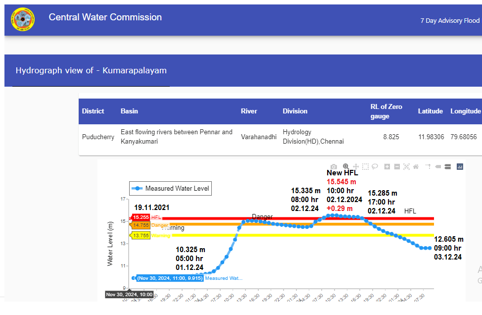
In addition to rivers flowing in extreme flood situations at 64 flooding monitoring stations during Southwest Monsoon 2024, we have found that rivers have crossed highest flood level (HFL) at four stations during just concluded Northeast Monsoon season. Of these four stations, three are in Tamil Nadu state and one is in Union Territory of Puducherry.
Continue reading “Rivers Flowing in Extreme Flood Situation during Northeast Monsoon 2024”Tag: Flood monitoring
SW Monsoon 2024: Rivers Crossing Highest Flood Levels
During southwest monsoon season 2024, SANDRP has tracked at least 64 flood forecast and flood monitoring sites where the respective rivers have crossed the highest flood levels (HFL). Here we present detailed analysis of these sites along with some key observations and other relevant information. SANDRP’s previous reports on the subject can be seen here: HFL breach incidents in 2018, 2019, 2020, May-Sept 2021, Oct.-Nov 2021, May-June 2022, July-October 2022, June-October 2023.
Continue reading “SW Monsoon 2024: Rivers Crossing Highest Flood Levels”
Delhi July 2023 Floods: Parliamentary Committee Report Raises More Questions
(Feature Image: Waterlogged Red Fort after heavy rainfall and rising Yamuna river water level in New Delhi on Friday (July 14, 2023). Image Credit: ANI/Gulf News)
In absence of any official report so far, the causes behind unusual flood spell in Delhi in July 2023 remains to be fully explained, understood and addressed. Amid this, the Parliamentary Standing Committee on Water Resources in its 27th report which was presented in Lok Sabha on February 06, 2024 has in a welcome step, deliberated on the issue under Chapter X titled “Role of Barrages on River Yamuna and Flood Management in Delhi” (60 to 66 pages) and has recommended some measures (page 86-88) to avoid its reoccurrence.
A careful reading of the chapter has only compounded the flood mystery and thrown some questions on the operation and management of Wazirabad and ITO barrages. The report has also revealed some contradictory and confusing statements by Central Water Commission (CWC), Upper Yamuna River Board (UYRB) and Haryana Government.
Continue reading “Delhi July 2023 Floods: Parliamentary Committee Report Raises More Questions”
Aug 2023 Floods in Alaknanda-Ganga Rivers
(Feature Image: Ganga river flowing in severe flood condition in Rishikesh on August 14, 2023. Image Credit: PTI/ Source: DH)
On August 14, 2023, there was flash flood in Alaknanda rivers in Uttarakhand causing sharp rise in water level at Center Water Commission (CWC) stations along Alaknanda upto Devprayag and then along Ganga in Rishikesh and Haridwar. The volume of water was so huge that it narrowly missed breaching the June 2013 peak flood level at Rishikesh and Haridwar site. This report tries to analyze hydrographs of 15 CWC flood monitoring sites on Alaknanda and Ganga rivers to assess the actual flood levels in these rivers during this flood spell in comparison with the previous peak flood levels attained on these sites.
Continue reading “Aug 2023 Floods in Alaknanda-Ganga Rivers”
Rivers Breaching Highest Flood Levels in July 2023
( Feature Image: CWC’s water level gauge set up along Yamuna river at Old Railway Bridge, Delhi. 28 June 2023/ SANDRP)
The analysis of hydrographs being published on Center Water Commission’s (CWC) Flood Forecasting website shows that the previous Highest Flood Levels (HFL) have been breached at least at 34 flood monitoring sites across the country in July 2023. The river basin wise details of all these sites are given in tables below.
Continue reading “Rivers Breaching Highest Flood Levels in July 2023”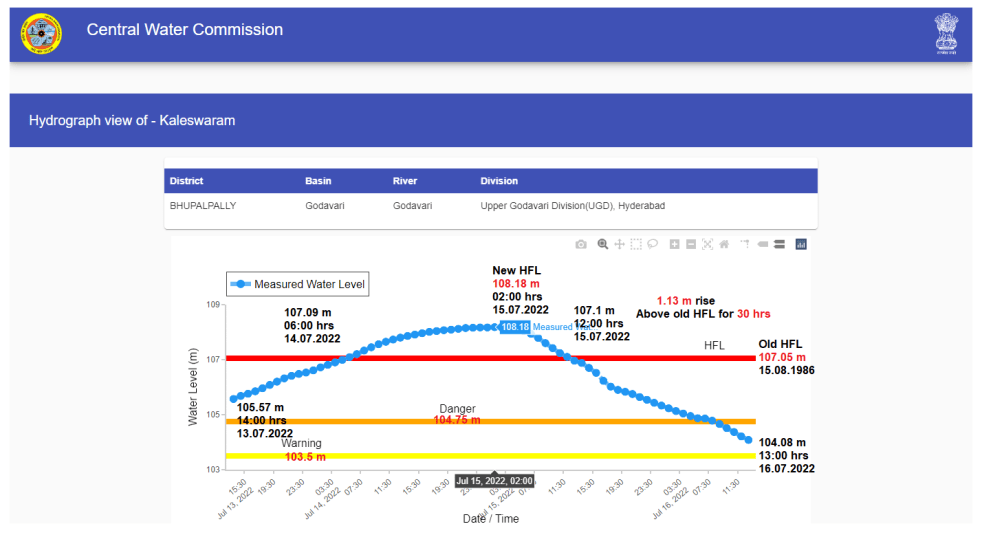
India’s Rivers Breaching High Flood Levels in SW Monsoon 2022
(Feature Image: Hydrograph of River Godavari in extreme flood situation at Kaleswaram level forecast station in Bhupalpally district, Telangana on July 15, 2022. Source: CWC)
Highest Flood Level (HFL) breach incidents are important indicator of flood cycle and could also help in understanding the changing rainfall pattern. Though, with 925 mm rainfall[i], the south west monsoon season 2022 falls in normal category, its distribution both temporally and spatially has seen huge variations. This is also reflected by at least 57 HFL breach incidents in 8 river basin across the country during the SW Monsoon months of July-Sept 2022.
For past four years, SANDRP has been tracking the HFL breach incidents during pre-monsoon and monsoon months. The analysis of such HFL breaches in 2018[ii], 2019[iii] and 2020[iv], May-Sept 2021[v], Oct.-Nov 2021[vi] can be seen on our website. The pre-monsoon months of May and June 2022[vii] have also seen 5 HFL breach incidents. This report tracks the other HFL breach incidents taking place between July and September months.
Continue reading “India’s Rivers Breaching High Flood Levels in SW Monsoon 2022“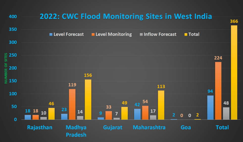
2022: Overview of CWC Flood Monitoring Sites in West India
(Feature Image: Bar chart showing CWC flood monitoring sites excluding UTs of Dadar & Nagar Haveli and Daman & Diu in West India in 2022)
Since 2018, SANDRP has been presenting detailed overviews on flood monitoring sites[i] of Central Water Commission (CWC) which is the only agency doing flood forecast work in India. This year, we have published and highlighted the inaccuracies in CWC’s flood monitoring sites in North[ii], North East[iii] and East[iv] zones. This fourth overview covers the West zone for Rajasthan, Madhya Pradesh, Gujarat, Maharashtra and Goa states. The previous overviews for the region can be seen here (2018[v]) and here (2019[vi]).
Continue reading “2022: Overview of CWC Flood Monitoring Sites in West India“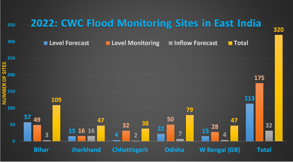
2022: CWC Flood Monitoring Sites in East India
Flood forecast and monitoring is essential part of Central Water Commission’s (CWC) work. Presently, the agency claims[I] issuing flood forecasts at 332 sites including 133 Inflow Forecast (IF) sites and 199 Level Forecast (LF) sites. Since 2018, SANDRP has been presenting critical analysis of CWC’s flood forecast website[II] in region wise manner.
In 2022 SW monsoon season, we have already published the overviews for North[III] and North East[IV] regions of the country. This third part in the series covers the states in East India including Bihar, Jharkhand, Chhattisgarh, Odisha and West Bengal (Ganga Basin). Our previous overviews for the region can be seen here (2018[V]) and here (2019[VI]).
Continue reading “2022: CWC Flood Monitoring Sites in East India“
2022: Overview of CWC’s Flood Monitoring Sites in North East India
During monsoon CWC (Central Water Commission) monitors water level at several hundred sites in the county and publishes this information on its Flood Forecast website[I]. The website has three ways to get this information: Data Flow Map, List Based Exploration, and Hydrograph view. The Hydrograph view provides information for past 72 hours, supposed to be updated every hour. This is in addition to the list of current forecasts listed on the website.
Since 2018, SANDRP has been analyzing CWC’s flood forecast website in zone wise manner. After examining status of flood forecast and monitoring sites in North Indian[II] states, this overview is for North East India region covering Arunachal Pradesh, Assam, Meghalaya, Manipur, Nagaland, Tripura, Mizoram and Sikkim states. This also includes part of North West Bengal that is in Brahmaputra basin. Our 2018 and 2019 analysis on the North East region can be seen here[III] and here[IV]. .
Continue reading “2022: Overview of CWC’s Flood Monitoring Sites in North East India“
2022: CWC Flood Monitoring Sites in North India
(Feature image: Bar Chart showing number of Level Forecast/Monitoring, Inflow Forecast sites in North Indian States & UTs)
Continuing analysis of Central Water Commission’s flood forecast website, SANDRP presents the details of flood monitoring sites in North Indian states comprising Union Territories of Jammu & Kashmir, Ladakh, Chandigarh, Delhi and states of Himachal Pradesh, Uttarakhand, Punjab, Haryana and Uttar Pradesh. Before this, we have prepared similar critical reports and highlighted problematic issues in flood monitoring sites in North India in 2018, 2019 and 2020.
Continue reading “2022: CWC Flood Monitoring Sites in North India“