Flood forecast and monitoring is essential part of Central Water Commission’s (CWC) work. Presently, the agency claims[I] issuing flood forecasts at 332 sites including 133 Inflow Forecast (IF) sites and 199 Level Forecast (LF) sites. Since 2018, SANDRP has been presenting critical analysis of CWC’s flood forecast website[II] in region wise manner.
In 2022 SW monsoon season, we have already published the overviews for North[III] and North East[IV] regions of the country. This third part in the series covers the states in East India including Bihar, Jharkhand, Chhattisgarh, Odisha and West Bengal (Ganga Basin). Our previous overviews for the region can be seen here (2018[V]) and here (2019[VI]).
Abbreviation List
| SN | Abbreviation | Short Form |
| 1 | Level Forecast | LF |
| 2 | Level Monitoring | LM |
| 3 | Inflow Forecast | IF |
| 4 | Meters | M |
| 5 | Warning Level | WL |
| 6 | Danger Level | DL |
| 7 | Highest Flood Level | HFL |
| 8 | Hydrograph Active | HA |
| 9 | Not Updated | NU |
| 10 | Full Reservoir Level | FRL |
| 11 | Maximum Water Level | MWL |
| 12 | Not Available | NA |
| 13 | Seasonal | (S) |
| 14 | East Flowing Rivers Between | EFR B |
BIHAR
In 2018, CWC’s FF website had a total of 58 sites from Bihar comprising of 35 LF and 23 LM sites. CWC added 60 LM (of which 2 were added after the overview) and 3 IF sites (Gandak, Indrapuri, Kosi) in the state in 2019. It also upgraded 6 LM sites – Dheng Bridge, Runisaidpur, Taibpur, Araria, Sonbarsa, Jainagar into LF sites. In total, CWC had 121 sites comprised of 41 LF, 77 LM and 3 IF sites in 2019.
Between 2019 and August 2022, CWC has upgraded 15 LM sites in LF sites and wrongly added Chapra as new LF site in Saran district. The Chapra site was earlier in Nadia district of West Bengal. Its hydrograph is active but not updated. CWC has also added 3 new LM sites (India Nepal Border Bhutahi, Sultanganj and Bagaha) and removed 15 LM sites from the state.
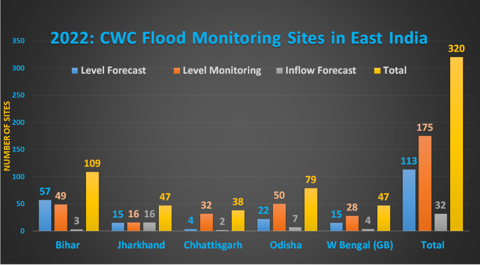
As of September 2022, there are 109 flood monitoring stations in Bihar including 57 LF, 49 LM and 3 IF sites. In LF sites, the HFL dates for Triveni on Gandak river and Galgalia on Mechi river are not mentioned while the hydrograph for Kanti site on Burhi Gandak is inactive. The HFL for Indrapuri site on Sone River which was changed to 109m from 108.85m in 2019 is reversed again. CWC keeps doing such changes without giving any convincing explanations.
Out of 49 LM sites, 24 sites have no HFL, HFL attaining dates while hydrograph for 29 sites are inactive and not updated for 11 other sites. The HFL date for Birpur site on Kosi River is missing.
Out of 3 IF sites, Indrapuri Barrage on Sone River is inactive while hydrograph for Kosi Barrage on Kosi River is running slow. Hence, presently only one IF site Gandak Barrage on Gandak river is properly functioning.
CWC has made several changes in the sites, rivers and district names. It has also updated the HFL, dates for several sites. The changes are mentioned in the tables below with main sites including the updated HFL, dates while the previous details and old HFL, dates are given in next rows.
The details of all added, removed and upgraded sites is given in separate tables. The Sultanganj new LM site was earlier in Devghar district of Jharkhand.
Note:- All the rivers in the state are part of Ganga basin and the basin category along with river in the tables is excluded to adjust column width. We have used Ps Champaran for Pashchim Champaran and Pb Champaran for Purba Champaran for the same purpose in the tables.
Bihar: List of Level Forecast Sites in 2022
| SN | Sites | River | District/Town | WL, M | DL, M | HFL, M | HFL Date | HA? |
| 1 | Buxar | Ganga | Buxar | 59.32 | 60.32 | 62.09 | 01.08.1948 | Yes |
| 2 | Dighaghat | Ganga | Patna | 49.45 | 50.45 | 52.52 | 23.08.1975 | Yes |
| 3 | Hathidah | Ganga | Patna | 40.76 | 41.76 | 43.52 | 16.08.2021 | Yes |
| 43.17 | 21.08.2016 | |||||||
| 4 | Gandhighat | Ganga | Patna | 47.6 | 48.6 | 50.52 | 21.08.2016 | Yes |
| 5 | Munger | Ganga | Munger | 38.33 | 39.33 | 40.99 | 19.09.1976 | Yes |
| 6 | Bhagalpur | Ganga | Bhagalpur | 32.68 | 33.68 | 34.86 | 18.08.2021 | Yes |
| 34.72 | 26.08.2016 | |||||||
| 7 | Kahalgaon | Ganga | Bhagalpur | 30.09 | 31.09 | 32.87 | 17.09.2003 | Yes |
| 8 | Triveni | Gandak | Ps. Champaran | 108.67 | 109.67 | 112.79 | NA | NU |
| Banka | ||||||||
| 9 | Chatia | Gandak | Ps. Champaran | 68.15 | 69.15 | 70.04 | 26.07.2002 | Yes |
| Motihari | ||||||||
| 10 | Dumariaghat | Gandak | Gopalganj | 61.22 | 62.22 | 64.36 | 24.07.2020 | Yes |
| 64.1 | 17.08.2017 | |||||||
| 11 | Rewaghat | Gandak | Muzaffarpur | 53.41 | 54.41 | 55.46 | 24.07.2020 | Yes |
| 55.41 | 17.09.1986 | |||||||
| 12 | Lalganj | Gandak | Vaishali | 49.5 | 50.5 | 51.83 | 02.09.2021 | Yes |
| 51.624 | 04.08.2001 | Yes | ||||||
| 13 | Hajipur | Gandak | Vaishali | 49.32 | 50.32 | 50.93 | 18-08-1948 | Yes |
| 14 | Indrapuri | Sone | Rohtas | 107.2 | 108.2 | 108.85 | 23.08.1975 | Yes |
| 109.6 | ||||||||
| 15 | Koelwar | Sone | Patna | 54.52 | 55.52 | 58.88 | 20.07.1971 | Yes |
| 16 | Maner | Sone | Patna | 51 | 52 | 53.79 | 10.09.1976 | Yes |
| 17 | Chanpatia | Burhi Gandak | Ps. Champaran | 72.68 | 73.68 | 76.68 | 15.09.1986 | Yes |
| 18 | Lalbegiaghat | Burhi Gandak | Pb. Champaran | 62.2 | 63.2 | 67.09 | 30.07.1975 | Yes |
| 19 | Ahirwalia | Burhi Gandak | Pb. Champaran | 58.62 | 59.62 | 61.17 | 06.08.1975 | Yes |
| 20 | Kanti | Burhi Gandak | Muzaffarpur | 53.09 | 54.09 | 56.45 | 20.07.2019 | No |
| 55.88 | 22.08.2017 | |||||||
| 21 | Sikandarpur | Burhi Gandak | Muzaffarpur | 51.53 | 52.53 | 54.29 | 15.08.1987 | Yes |
| 22 | Sakra | Burhi Gandak | Muzaffarpur | 49.58 | 50.58 | 51.47 | 12.07.2021 | NU |
| 50.87 | 15.08.2017 | |||||||
| 23 | Samastipur | Burhi Gandak | Samastipur | 45.02 | 46.02 | 49.38 | 15.08.1987 | Yes |
| 24 | Rosera | Burhi Gandak | Samastipur | 41.63 | 42.63 | 46.56 | 03.08.2020 | Yes |
| 46.35 | 16.08.1987 | |||||||
| 25 | Khagaria | Burhi Gandak | Khangaria | 35.58 | 36.58 | 39.22 | 16.08.1976 | Yes |
| 26 | Darauli | Ghagra | Siwan | 59.82 | 60.82 | 61.74 | 29.08.1998 | Yes |
| 27 | Gangpur | Ghagra | Siwan | 56.04 | 57.04 | 58.01 | 18.09.1983 | NU |
| 28 | Chhapra | Ghagra | Saran | 52.68 | 53.68 | 54.59 | 03.09.1982 | Yes |
| 29 | Sonbarsa | Adhwara | Sitamarhi | 80.85 | 81.85 | 83.2 | 03.07.1999 | Yes |
| 83 | NA | |||||||
| 30 | Saharghat | Adhwara | Madhubani | 54.5 | 55.5 | 58.25 | 14.07.2019 | NU |
| 58.07 | 14.08.2017 | |||||||
| 31 | Saulighat | Adhwara | Madhubani | 51.37 | 52.37 | 55.1 | 12.07.2004 | Yes |
| 32 | Kamtaul | Adhwara | Darbhanga | 49.0 | 50.0 | 52.99 | 12.08.1987 | NU |
| 33 | Ekmighat | Adhwara | Darbhanga | 45.94 | 46.94 | 49.52 | 12.07.2004 | Yes |
| 34 | Dheng Bridge | Bagmati | Sitamarhi | 70 | 71 | 73 | 13.08.2017 | Yes |
| 69.1 | 70.1 | |||||||
| 35 | Runisaidpur | Bagmati | Muzaffarpur | 54 | 55 | 58.15 | 14.08.2017 | Yes |
| Sitamarhi | 52.73 | 53.73 | ||||||
| 36 | Benibad | Bagmati | 47.68 | 48.68 | 50.01 | 12.07.2004 | Yes | |
| 37 | Bishunpur | Bagmati | Darbhanga | 46.4 | 47.4 | 48.97 | 05.08.2020 | NU |
| Adhwara | 48.04 | 24.08.2017 | ||||||
| 38 | Hayaghat | Bagmati | Darbhanga | 44.72 | 45.72 | 48.96 | 14.08.1987 | Yes |
| 39 | Taibpur | Mahananda | Kishangani | 65 | 66 | 67.22 | 10.08.1968 | Yes |
| 40 | Chargharia | Mahananda | Kishangani | 45.94 | 46.94 | 48.85 | 13.08.2017 | Yes |
| 41 | Dhengraghat | Mahananda | Purnia | 34.65 | 35.65 | 38.2 | 14.08.2017 | Yes |
| 42 | Jhawa | Mahananda | Katihar | 30.4 | 31.4 | 34.07 | 14.08.2017 | Yes |
| 43 | LABHA | Mahananda | Katihar | 29.5 | 30.5 | 30.79 | 15.08.2017 | NU |
| 44 | Basua | Kosi | Supaul | 46.75 | 47.75 | 49.24 | 13.08.2017 | Yes |
| 45 | Baltara | Kosi | Khagaria | 32.85 | 33.85 | 36.4 | 15-08-1987 | Yes |
| 46 | Kursela | Kosi | Katihar | 29 | 30 | 32.1 | 07.09.1982 | Yes |
| 32.04 | 06.09.1998 | |||||||
| 47 | Kadirganj | Harohar | Nawada | 85 | 86 | 86.52 | 23.09.2006 | Yes |
| 48 | Mankatha | Harohar | Lakhisarai | 39.786 | 40.78 | 42.82 | 21.09.1976 | Yes |
| Aurangabad | ||||||||
| 49 | Kinjer | Punpun | Arwal | 64 | 65 | 67.95 | 14.09.1987 | Yes |
| Jahanabad | ||||||||
| 50 | Sripalpur | Punpun | Patna | 49.6 | 50.6 | 53.91 | 18.09.1976 | Yes |
| 51 | Jainagar | Kamla | Madhubani | 66.75 | 67.75 | 71.35 | 01.08.1965 | Yes |
| 52 | Jhanjharpur | Kamalabalan | Madhubani | 49 | 50 | 53.11 | 14.07.2019 | Yes |
| 53.01 | 10.07.2004 | |||||||
| 53 | Galgalia | Mechi | Kishanganj | 81.3 | 82.3 | 83.66 | NA | Yes |
| 54 | Kolhachak | Dhardha | Patna | 54.48 | 55.48 | 55.99 | 30.09.2019 | No |
| 55 | Araria | Parman | Araria | 46 | 47 | 49.4 | 14.08.2017 | Yes |
| Mahananda | 47.3 | |||||||
| 56 | Lakhisarai | Kiul | Munger | 41.347 | 42.347 | 45.85 | 17.09.1976 | Yes |
| 57 | CHAPRA | Jalangi | Saran | 10.435 | 10.961 | 12.03 | 24.09.2000 | NU |
| Nadia | NA | NA |
Bihar: List of Level Monitoring Sites in 2022
| SN | Sites | River | District/Town | HFL, M | Date | HA? |
| 1 | Indo Nepal Border (Bhutahi) | Ganga | Sitamarhi | 70.2 | 13.07.2019 | NU |
| 2 | Ahiro | Ganga | Banka | NA | NA | No |
| 3 | Udwantnagar | Ganga | Bhojpur | NA | NA | No |
| 4 | Manpur | Ganga | Lakhisarai | NA | NA | No |
| Gaya | ||||||
| 5 | Suryagadha | Ganga | Lakhisarai | NA | NA | No |
| 6 | Hisua | Ganga | Nawada | NA | NA | No |
| 7 | Nadirganj | Ganga | Nawada | NA | NA | No |
| 8 | Nawada | Ganga | Nawada | NA | NA | No |
| 9 | Danapur | Ganga | Patna | NA | NA | No |
| 10 | Sitalpur | Ganga | Saran | NA | NA | No |
| 11 | Mahnar | Ganga | Vaishali | NA | NA | NU |
| 12 | Sultanganj | Ganga | Bhagalpur | NA | NA | Yes |
| Devghar | ||||||
| 13 | Bagaha | Gandak | Ps. Champaran | 90.08 | 27.08.2021 | No |
| 14 | Thakraha | Gandak | Ps. Champaran | 78.68 | 23.07.2020 | No |
| Gopalganj | ||||||
| 15 | Kukraha | Gandak | Gopalganj | 71.9 | 31.08.2021 | NU |
| 16 | Mahua | Gandak | Vaishali | NA | NA | Yes |
| 17 | Bairgania | Burhi Gandak | Sitamarhi | 72.22 | 13.07.2020 | Yes |
| Bergenia | NA | NA | Yes | |||
| 18 | Sugauli | Burhi Gandak | Pb. Champaran | 69 | 24.07.2020 | NU |
| 19 | Lakhoura | Burhi Gandak | Pb. Champaran | 64.25 | 29.07.2020 | NU |
| 20 | Chintawanpur | Burhi Gandak | Pb. Champaran | 62.95 | 07.07.2021 | NU |
| 21 | Madhuban | Burhi Gandak | Pb. Champaran | 61.69 | 15.07.2019 | No |
| 22 | Birpur | Kosi | Supaul | 76.01 | NA | Yes |
| 23 | Nirmali | Kosi | Sapaul | 55.28 | 28.09.2020 | NU |
| 24 | Dalsingh Sarai | Kosi | Samstipur | 44.34 | 14.08.2020 | NU |
| 25 | Dhamaraghat | Kosi | Khangaria | 37.74 | 03.08.2020 | No |
| 26 | DURGAWATI | Karmnasa | Kaimur | 70.98 | 01.10.2019 | Yes |
| 27 | CHOUSA | Karmansa | Baxur | 62.89 | 25.09.2019 | Yes |
| 28 | Bathnaha | Parman | Araria | 63.61 | 21.10.2021 | Yes |
| 29 | Amour | Parman | Purnia | 39.88 | 16.07.2019 | Yes |
| 30 | Sikti | Mahananda | Araria | 62.9 | 20.10.2021 | NU |
| 31 | Moujabadi | Mahananda | Kishanganj | 53.55 | 28.06.2020 | No |
| 32 | Belsand | Bagmati | Sitamarhi | 60.05 | 28.08.2021 | NU |
| 33 | Badlaghat | Bagmati | Khangaria | 37.79 | 01.08.2020 | No |
| 34 | Kakarghatti | Kamalabalan | Darbhanga | 49 | 25.07.2020 | NU |
| 35 | Kapasiya | Kamalabalan | Madhubani | 45.28 | 23.07.2020 | No |
| 36 | Jhagarua | Kamalabalan | Darbhanga | 14.72 | 14.07.2020 | No |
| 37 | Mohauddin Nagar | Baya | Samstipur | 44.97 | 17.08.2021 | No |
| 38 | Bachhwara | Baya | Begusarai | NA | NA | No |
| 39 | Rauta | West Kankai | Purnia | 43.21 | 15.07.2019 | No |
| 40 | Paliganj | Sone | Patna | NA | NA | No |
| 41 | Banjari | Sone | Rohtas | NA | NA | No |
| 42 | Yadunathpur | Sone | Rohtas | NA | NA | No |
| 43 | Jehanabad | Dhardha | Jehanabad | NA | NA | No |
| 44 | Masaurhi | Dhardha | Patna | NA | NA | No |
| 45 | Dobhi | Phalgu | Gaya | NA | NA | No |
| 46 | Saksohra | Phalgu | Patna | NA | NA | No |
| Ganga | ||||||
| 47 | Fatehpur | Punpun | Patna | NA | NA | NU |
| 48 | Banka | Chandan | Banka | NA | NA | No |
| 49 | Jamui | Kiul | Jamui | NA | NA | No |
| Ganga |
Bihar List of Inflow Forecast Sites in 2022
| SN | Site | River | District/Town | FRL | MWL | HA? |
| 1 | Gandak Barrage | Gandak | Ps. Champaran | 110.3 | 113.05 | Yes |
| 2 | Indrapuri Barrage | Sone | Rohtas | NA | NA | No |
| 3 | Kosi Barrage | Kosi/ | Sapaul | 74.69 | 79.26 | NU |
Bihar: List of Level Monitoring Sites UPGRADED into Level Forecast Sites in 2022
| SN | Sites | River | District/Town | WL, M | DL, M | HFL, M | HFL Date |
| 1 | Triveni | Gandak | Ps. Champaran | 108.67 | 109.67 | 112.79 | NA |
| 2 | Lalganj | Gandak | Vaishali | 49.5 | 50.5 | 51.83 | 02.09.2021 |
| 3 | Kadirganj | Harohar | Nawada | 85 | 86 | 86.52 | 23.09.2006 |
| 4 | Mankatha | Harohar | Lakhisarai | 39.786 | 40.78 | 42.82 | 21.09.1976 |
| 5 | Galgalia | Mechi | Kishanganj | 81.3 | 82.3 | 83.66 | NA |
| 7 | Saharghat | Adhwara | Madhubani | 54.5 | 55.5 | 58.25 | 14.07.2019 |
| 6 | Saulighat | Adhwara | Madhubani | 51.37 | 52.37 | 55.1 | 12.07.2004 |
| 8 | Chanpatia | Burhi Gandak | Ps. Champaran | 72.68 | 73.68 | 76.68 | 15.09.1986 |
| 9 | Sakra | Burhi Gandak | Muzaffarpur | 49.58 | 50.58 | 51.47 | 12.07.2021 |
| 10 | Kanti | Burhi Gandak | Muzaffarpur | 53.09 | 54.09 | 56.45 | 20.07.2019 |
| 11 | Kinjer | Punpun | Arwal | 64 | 65 | 67.95 | 14.09.1987 |
| 12 | Kolhachak | Dhardha | Patna | 54.48 | 55.48 | 55.99 | 30.09.2019 |
| 13 | Bishunpur | Bagmati | Darbhanga | 46.4 | 47.4 | 48.97 | 05.08.2020 |
| 14 | Chargharia | Mahananda | Kishangani | 45.94 | 46.94 | 48.85 | 13.08.2017 |
| 15 | LABHA | Mahananda | Katihar | 29.5 | 30.5 | 30.79 | 15.08.2017 |
Bihar: List of Level Forecast Sites ADDED in 2022
| SN | Sites | River | District | WL, M | DL, M | HFL, M | HFL Date |
| 1 | CHAPRA | Jalangi | Saran | 10.435 | 10.961 | 12.03 | 24.09.2000 |
Bihar: List of Level Monitoring Sites ADDED in 2022
| SN | Sites | River | District | HFL, M | Date |
| 1 | Bhutahi (I-N Border) | Ganga | Sitamarhi | 70.2 | 13.07.2019 |
| 2 | Sultanganj | Ganga | Bhagalpur | NA | NA |
| 3 | Bagaha | Gandak/Gannga | Ps. Champaran | 90.08 | 27.08.2021 |
Bihar: List of Level Monitoring Sites REMOVED in 2022
| SN | Sites | River | District | HFL, M | Date |
| 1 | Azamabad | Ganga | Bhagalpur | 32.41 | 23.08.1971 |
| 2 | Ekchari | Ganga | Bhagalpur | NA | NA |
| 3 | Moujampur | Ganga | Gaya | NA | NA |
| 4 | Bariyarpur | Ganga | Munger | NA | NA |
| 5 | GIRIAK | Ganga | Nalanda | NA | NA |
| 6 | Bankaghat | Ganga | Patna | NA | NA |
| 7 | Barh/Pandarak | Ganga | Patna | NA | NA |
| 8 | Kalyanpur | Ganga | Samstipur | NA | NA |
| 9 | Doriganj | Ganga | Saran | NA | NA |
| 10 | Dighwara | Ganga | Vaishali | NA | NA |
| 11 | Palmerganj | Punpun | Aurangabad | 99.13 | 18-09-1976 |
| 12 | Gaya | Phalgu | Gaya | 111.3 | 07-09-2009 |
| 13 | Kathautiya | North Koel | Gaya | NA | NA |
| 14 | Bairiya | North Koel | Ps. Champaran | NA | NA |
| 15 | Manjhi | Sarju | Saran | NA | NA |
JHARKHAND
The number of flood monitoring sties in Jharkhand state went up from 27 (including 2 LF, 14 LM and 11 IF sites) in 2018 to 46 (comprised of 2 LF, 29 LM and 15 IF sites) in 2019. As of September 2022, CWC has added one more site in the state taking total tally to 47 sites comprised of 15 LF, 16 LM and 16 IF sites.
In past 2 years, CWC has upgraded 10 LM sites into LF sites and added 3 new LF sites. Out of total new LF sites, 6 sites have no WL while hydrograph for 10 sites is not updated. The Tantloi and Palmerganj sties were previously listed under Birbhum district of West Bengal and Aurangabad district of Bihar.
CWC has also removed 11 old LM sites and has added 8 new LM sites. The Sikatia Barrage LM site was previously listed in Bardhaman district of West Bengal while Bairiya and Kathautiya LM sites were listed in Pashchim Champaran and Gaya districts of Bihar.
Out of total 16 LM sites, HFL, HFL attaining date information is missing for 11 sites while hydrographs for 8 LM sites is inactive. Similarly, hydrographs for 4 LM sites is running late by several hours.
CWC has added one more IF site, namely Narayanpuram Anicut on Nagavali river which is part of East Flowing Rivers between Mahanadi and Pennar. Out of total 16 IF sites, FRL is missing for 4 sites while MWL is unavailable for 6 sites. CWC has not mentioned HFL, HFL attaining Date information for 10 IF sites.
Surprisingly, hydrographs for 7 IF sites are INACTIVE while not being updated for 9 other IF sites. Hence none of the IF site is functioning properly even during active monsoon season in Jharkhand.
If the sites with inactive hydrographs are excluded, the actual number of active sites will come down to 32 in the state.
Apart from this, CWC has made changes in site name, rivers, districts, HFL, HFL attaining Dates, FRL and MWL for several sites. The previous information pertaining to these sites is mentioned in next rows for easy reference in our tables blow.
Jharkhand List of Level Forecast Sites in 2022
| SN | Site | River/Basin | District | WL, M | DL, M | HFL, M | Date | HA? |
| 1 | Sahibganj | Ganga/Ganga | Sahibganj | 26.25 | 27.25 | 30.91 | 20.08.1998 | Yes |
| 2 | Rajmahal | Ganga/Ganga | Sahibganj | NA | 25.99 | 26.94 | 19.09.2003 | NU |
| 3 | Hendegir | Damodar/ Ganga | Ranchi | NA | 365.3 | 368.858 | 26.09.1978 | NU |
| 4 | Ramgarh | Damodar/ Ganga | Ramgarh | NA | 307.51 | 316.68 | 26.09.1978 | NU |
| Hazaribag | ||||||||
| 5 | Pupunki | Damodar/ Ganga | Dhanbad | NA | 153.5 | 160.05 | 21.08.1976 | NU |
| 6 | Barkisuriya | Barakar/ Ganga | Giridih | 288.4 | 289.4 | 292.32 | 17.09.2004 | NU |
| 291.54 | 25.09.2007 | NU | ||||||
| 7 | Nandadih1 | Barakar/Ganga | Giridih | 193.21 | 194.21 | 200.395 | 27.09.1995 | NU |
| Dhanbad | 200.644 | NA | ||||||
| 8 | Daltonganj | North Koel/ Ganga | Palamu | 208 | 209 | 210.91 | 17.09.1976 | Yes |
| Daltenganj | Ganga | |||||||
| 9 | Mohammad Ganj | North Koel/ Ganga | Palamu | 144.52 | 145.52 | 146.66 | 19.08.2016 | Yes |
| 10 | Maharo | Mayurakshi/ Ganga | Dumka | NA | 128.165 | 139.03 | 21.09.2000 | NU |
| 11 | Japla | Sone/ Ganga | Palamu | 124.09 | 125.09 | 128.04 | 15.08.1975 | Yes |
| 12 | TANTLOI | Sidheswari/ Ganga | Dumka | 94.406 | 95.406 | 100.425 | 27-09-1978 | NU |
| Birbhum | ||||||||
| 13 | Palmerganj | Punpun/Ganga | Lohardaga | 96.5 | 97.5 | 99.13 | 18.09.1976 | Yes |
| Aurangabad | ||||||||
| 14 | BERHAIT | Gumani/ Ganga | Sahibganj | NA | 47.53 | 48.8 | 16.07.1977 | NU |
| 15 | Jamshedpur | Subarnarekha | Purbi Singbhum | 122.5 | 123.5 | 129.82 | 12.10.1973 | Yes |
Jharkhand List of Level Monitoring Sites in 2022
| SN | Site | River/Basin | District | HFL, M | Date | HA? |
| 1 | Sikatia Barrage | Ajoy/ Ganga | Deoghar | 169.24 | 27.09.1995 | NU |
| Bardhaman | ||||||
| 2 | Jamtara1 | Ajoy/ Ganga | Jamtara | 146.5 | 20.09.2000 | NU |
| 3 | Haripur | Tepra/ Ganga | Dumka | 137.1 | 28.09.2008 | Yes |
| 4 | Garhwa | North Koel/ Ganga | Palamu | NA | NA | NU |
| 5 | Bairiya | North Koel/ Ganga | Palamu | NA | NA | No |
| Ps. Champaran | ||||||
| 6 | Kathautiya | North Koel/ Ganga | Palamu | NA | NA | NU |
| Gaya | ||||||
| 7 | PUTKI | Damodar/ Ganga | Dhanbad | NA | NA | No |
| 8 | Mahagama | Sundar/Ganga | Godda | NA | NA | No |
| 9 | Muri | Subarnarekha | Ranchi | 238.12 | 09.07.2008 | Yes |
| 10 | Rd.Bridge D/S Chandil Dam | Dulang/ Subarnarekha | Purbi Singhbhum | NA | NA | Yes |
| 11 | Adityapur | Karkari/ Subarnarekha | Paschim Singbhum | 137.8 | 18.06.2008 | Yes |
| 12 | Kanke Rd Bridge | Jumar/ Subarnarekha | Ranchi | NA | NA | No |
| 13 | Saraikela Rd Bridge | Kharkhai/ Subarnarekha | Pashchim Singhbhum | NA | NA | No |
| 14 | Bada Ghagara | Vaitarna/ Subarnarekha | Ranchi | NA | NA | No |
| 15 | Dhurwa Dam | Gara/ Subarnarekha | Ranchi | NA | NA | No |
| 16 | Paradih | Kanchi/ Subarnarekha | Ranchi | NA | NA | No |
Jharkhand List of Inflow Forecast Sites in 2022
| SN | Site | River/Basin | District | FRL | MWL | HFL, M | Date | HA? |
| 1 | BHAIRWA DAM | Damodar/ Ganga | Hazaribag | NA | NA | NA | NA | No |
| 356.707 | 359.756 | |||||||
| 2 | Tenughat Reservoir | Damodar/ Ganga | Bokaro | 268.834 | 268.83 | 265.56 | 17.09.1985 | NU |
| 3 | Panchat Reservoir | Damodar/ Ganga | Dhanbad | 132.59 | 132.59 | 132.893 | 02.10.1959 | NU |
| 4 | Amanat Barrage | North Koel/ Ganga | Palamu | 274.39 | 269.9 | NA | NA | No |
| Son | ||||||||
| 5 | Anraj Dam | North Koel/ Ganga | Gharwa | 252.44 | NA | NA | NA | No |
| Son | ||||||||
| 6 | Batane | Batane/ Ganga | Palamu | 232.85 | 226.618 | NA | NA | No |
| 7 | Maithon Dam | Barakar/ Ganga | Dhanbad | 150.88 | 151.79 | 151.79 | 01.10.1959 | NU |
| 8 | Tilaiya Reservoir | Barakar/ Ganga | Hazaribag | NA | NA | 372.28 | 06.07.1986 | NU |
| 9 | Massanjore Dam | Mayurakshi/ Ganga | Dumka | 121.31 | 122.87 | 131.6 | 20.10.1959 | NU |
| Santhal Parganas | ||||||||
| 10 | Sundar Reservoir | Sundar/Ganga | Godda | 110.795 | 112.85 | NA | NA | No |
| 110.868 | 112.85 | |||||||
| 11 | Konar Dam | Konark/ Ganga | Hazaribag | NA | NA | 427.91 | 01.10.1961 | NU |
| 12 | PUNASI DAM | Ajoy/ Ganga | Deoghar | NA | NA | NA | NA | No |
| 13 | Getasut Reservoir | Subarnarekha | Ranchi | 590.06 | 590.06 | NA | NA | No |
| Getaslut | ||||||||
| 14 | Chandil Dam | Subarnarekha | Sahebganj | 189 | 192 | NA | NA | NU |
| Purba Singbhum | 192 | NA | ||||||
| 15 | Galudih Barrage | Subarnarekha | Pashchimi Singhbhum | 94.5 | 101.25 | NA | NA | NU |
| Dulang | Saraikela | |||||||
| 16 | Narayanpuram Anicut | Nagavali/ EFRs between Mahanadi-Pennar | Gumla | 32.77 | 32.77 | NA | NA | NU |
Jharkhand List of Level Monitoring Sites UPGRADED into Level Forecast in 2022
| SN | Site | River/Basin | District | WL, M | DL, M | HFL, M | Date |
| 1 | Rajmahal | Ganga/Ganga | Sahibganj | NA | 25.99 | 26.94 | 19.09.2003 |
| 2 | Ramgarh | Damodar/ Ganga | Ramgarh | NA | 307.51 | 316.68 | 26.09.1978 |
| 3 | Pupunki | Damodar/ Ganga | Dhanbad | NA | 153.5 | 160.05 | 21.08.1976 |
| 4 | Barkisuriya | Barakar/ Ganga | Giridih | 288.4 | 289.4 | 292.32 | 17.09.2004 |
| 5 | Nandadih1 | Barakar/Ganga | Giridih | 193.21 | 194.21 | 200.395 | 27.09.1995 |
| 6 | Daltonganj | North Koel/ Ganga | Palamu | 208 | 209 | 210.91 | 17.09.1976 |
| 7 | Mohammad Ganj | North Koel/ Ganga | Palamu | 144.52 | 145.52 | 146.66 | 19.08.2016 |
| 8 | Maharo | Mayurakshi/ Ganga | Dumka | 128.165 | 139.03 | 21.09.2000 | |
| 9 | Japla | Sone/ Ganga | Palamu | 124.09 | 125.09 | 128.04 | 15.08.1975 |
| 10 | BERHAIT | Gumani/ Ganga | Sahibganj | NA | 47.53 | 48.8 | 16.07.1977 |
Jharkhand List of Level Forecast Sites ADDED in 2022
| SN | Site | River/Basin | District | WL, M | DL, M | HFL, M | Date |
| 1 | Hendegir | Damodar/ Ganga | Ranchi | NA | 365.3 | 368.858 | 26.09.1978 |
| 2 | TANTLOI | Sidheswari/ Ganga | Dumka | 94.406 | 95.406 | 100.425 | 27-09-1978 |
| 3 | Palmerganj | Punpun/Ganga | Lohardaga | 96.5 | 97.5 | 99.13 | 18.09.1976 |
Jharkhand List of Level Monitoring Sites ADDED in 2022
| SN | Site | River/Basin | District | HFL, M | Date |
| 1 | Sikatia Barrage | Ajoy/ Ganga | Deoghar | 169.24 | 27.09.1995 |
| 2 | Bairiya | North Koel/ Ganga | Palamu | NA | NA |
| 3 | Kathautiya | North Koel/ Ganga | Palamu | NA | NA |
| 4 | Kanke Rd Bridge | Jumar/ Subarnarekha | Ranchi | NA | NA |
| 5 | Saraikela Rd Bridge | Kharkhai/ Subarnarekha | Pashchim Singhbhum | NA | NA |
| 6 | Bada Ghagara | Vaitarna/ Subarnarekha | Ranchi | NA | NA |
| 7 | Dhurwa Dam | Gara/ Subarnarekha | Ranchi | NA | NA |
| 8 | Paradih | Kanchi/ Subarnarekha | Ranchi | NA | NA |
Jharkhand List of Level Monitoring Sites REMOVED in 2022
| SN | Site | River/ Basin | District | HFL, M | Date |
| 1 | BERIA | Barakar/ Ganga | Giridih | NA | NA |
| 2 | PALGANJ | Barakar/ Ganga | Giridih | NA | NA |
| 3 | CHANDRAPURA | Damodar/ Ganga | Bokaro | NA | NA |
| 4 | GHANSADIH | Damodar/ Ganga | Bokaro | NA | NA |
| 5 | Rajhara | Sone/ Ganga | Palamu | NA | NA |
| 6 | PHUSRO | Damodar/ Ganga | Bokaro | NA | NA |
| 7 | SUNDAR DAM | Sundar/ Ganga | Godda | NA | NA |
| 8 | Sultanganj | Ghagara/Ganga | Devghar | NA | NA |
| 9 | Ghatsila | Subarnarekha | Purba Singbhum | 86.835 | 13-10-1973 |
| 10 | Karkari Road Bridge | Karkari/ Subarnarekha | Saraikela | NA | NA |
| 11 | Tilga | Brahmni/ Brahmani- Baitarni | Gumla | 379.5 | 23-09-2011 |
Jharkhand List of Inflow Forecast site ADDED in 2022
| SN | Site | River | District | FRL | MWL | HFL, M | Date |
| 1 | Narayanpuram Anicut | Nagavali | Gumla | 32.77 | 32.77 | NA | NA |
CHHATTISGARH
There were 32 flood monitoring sites in Chhattisgarh in 2018 comprised of 1 LF, 31 LM sites. In 2019, CWC added 6 LM sites and 2 IF sites in the state taking total tally to 40 including 1 LF site, 37 LM sites and 2 IF sites.
As of September 2022, CWC has upgraded 3 LM sites into LF sites and added 2 new LM sites while removing 4 LM sites from the state. So, currently the state has 38 sites comprised of 4 LF, 32 LM and 2 IF sites.
The 3 LM sites including 2 newly added, namely Dudhawa and Murumsilli on Mahanadi lack and Raipur site on Kharun river lack HFL, HFL attaining Date and their hydrograph is inactive. Hence the actual number of active sites in the state is 35.
CWC has changed district name, HFL, HFL attaining date for several sites which are mentioned in separate rows after the respective sites in the tables below. The old HFL 260.15 m dated 10.08.1994 for Ghatora LM site on Arpa River is higher than updated HFL 254.65 m dated 21.07.1994. No explanation is given by CWC for these changes.
The current HFL, HFL attaining date for Andhiyar Khore LM on Hamp river are same as the old HFL of the Ghatora LM site. The hydrographs for most of the LM sites are running late by 2 to 3 hours.
Chhattisgarh List of Level Forecast Sites in 2022
| SN | Site | River/ Basin | District | WL, M | DL, M | HFL, M | Date | HA? |
| 1 | Jagdalpur | Indravathi/ Godavari | Bastar | 539.5 | 540.8 | 544.68 | 09.07.1973 | Yes |
| 2 | Pathagudem | Indravathi/ Godavari | Bijapur | 99.75 | 101.75 | 103.61 | 23.08.1990 | Yes |
| Dantewada | ||||||||
| 3 | Sukma | Sabari/Godavari | Dantewada | 198.065 | 199.565 | 203.4 | 05.09.1994 | Yes |
| 4 | Konta | Sabari/ Godavari | Sukma | 44.3 | 48.3 | 50.13 | 16.08.1986 | Yes |
| Dantewada |
Chhattisgarh List of Level Monitoring Sites in 2022
| SN | Site | River/Basin | District | HFL, M | Date | HA? |
| 1 | Sarangpal | Mahanadi | Kanker | 384.53 | 02.08.2016 | Yes |
| 2 | RAJIM | Mahanadi | Gariaband | 283.55 | 18.09.1980 | Yes |
| Raipur | 283.71 | |||||
| 3 | Seorinarayan | Mahanadi | Janjgir-champa | 224.635 | 30.08.2003 | Yes |
| 4 | Basantpur | Mahanadi | Jangir-champa | 219.82 | 20.09.1980 | Yes |
| 5 | Surajgarh | Mahanadi | Raigarh | 201.06 | 30.08.2020 | Yes |
| 199.9 | 30.08.2003 | |||||
| 6 | KALMA | Mahanadi | Janjgir-champa | 202.43 | 29.08.2020 | Yes |
| 201.4 | 08.08.2018 | |||||
| 7 | Dudhawa | Mahanadi | Dhamtari | NA | NA | No |
| 8 | Murumsilli | Mahanadi | Dhamtari | NA | NA | No |
| 9 | Manendragarh | Hasdeo/ Mahanadi | Korba | 420.86 | 12.07.1990 | Yes |
| 10 | Kataghora | Hasdeo/ Mahanadi | Korba | 312.98 | 17.09.2015 | Yes |
| 11 | Bango Dam | Hasdeo/ Mahanadi | Korba | 302.1 | 23.08.1984 | Yes |
| 12 | Korba | Hasdeo/ Mahanadi | Korba | 279.02 | 15.09.1987 | Yes |
| 13 | Bamnidhi | Hasdeo/ Mahanadi | Janjgir-champa | 229.225 | 20.08.1975 | Yes |
| 14 | Thethetanger | Ib/ Mahanadi | Jashpur | 365.615 | 28.08.1987 | Yes |
| Thettanagar | ||||||
| 15 | MALGAON | Pairi/ Mahanadi | Gariaband | 326.71 | 14.07.2022 | Yes |
| Raipur | ||||||
| 16 | Baronda | Pairi/ Mahanadi | Gariaband | 290.82 | 18.09.2008 | Yes |
| Raipur | 289.6 | 09.07.2001 | ||||
| 17 | Gunderdehi | Tandula/ Mahanadi | Balod | 296.7 | 05.08.2014 | Yes |
| Durg | ||||||
| 18 | Kotni | Seonath/ Mahanadi | Durg | 280.08 | 30.08.1978 | Yes |
| 19 | Simga | Seonath/ Mahanadi | Balod Bazar | 257.68 | 13.07.1994 | Yes |
| Raipur | ||||||
| 20 | Jondhra | Seonath/ Mahanadi | Bilaspur | 230.595 | 14.07.1994 | Yes |
| 21 | Pathardihi | Kharun/ Mahanadi | Raipur | 280.02 | 29.08.2020 | Yes |
| 279.21 | 12.07.1994 | Yes | ||||
| 22 | Raipur | Kharun/ Mahanadi | Raipur | NA | NA | No |
| 23 | Dharam Jaigarh | Mand/ Mahanadi | Raigarh | 279.575 | 27.07.1991 | Yes |
| 24 | Kurubhata | Mand/ Mahanadi | Raigarh | 220.4 | 28.08.2020 | Yes |
| 220.35 | 10.08.2004 | |||||
| 25 | Sankara | Jonk/ Mahanadi | Mahasamund | 271.18 | 29.08.2003 | Yes |
| 26 | Rampur | Jonk/ Mahanadi | Balod Bazar | 229.665 | 29.08.2003 | Yes |
| Raipur | 28.08.2003 | |||||
| 27 | Andhiyar Khore | Hamp/ Mahanadi | Bemetara | 260.15 | 09.10.1994 | Yes |
| Hasdeo | Durg | 10.08.1994 | ||||
| 28 | Ghatora | Arpa/ Mahanadi | Bilaspur | 254.65 | 21.07.1994 | Yes |
| 260.15 | 10.08.1994 | |||||
| 29 | Maniyari | Maniari/ Mahanadi | Mungeli | 235.88 | 30.08.2020 | Yes |
| Koriya | ||||||
| 30 | Kelo at Raigarh | Kelo/ Mahanadi | Raigarh | 229.69 | 15.08.2008 | Yes |
| 13.08.2008 | ||||||
| 31 | Chindnar | Indravathi/ Godavari | Dantewada | 340.2 | 05.07.2006 | Yes |
| 32 | Tumnar | Dantewada/ Godavari | Dantewada | 326.83 | 04.09.1994 | Yes |
| 326.84 |
Chhattisgarh List of Inflow Forecast Sites in 2022
| SN | Site | River/Basin | District/ Town | FRL | MWL | HA? |
| 1 | Ravishankar Sagar Dam | Mahanadi | Dhamtari | 348.7 | 350.7 | Yes |
| 2 | Bango Reservoir | Hasdeo/ Mahanadi | Korba | 359.66 | 363.08 | Yes |
Chhattisgarh List of Level Monitoring Sites UPGRADED into Level Forecast in 2022
| SN | Site | River/ Basin | District/ Town | WL, M | DL, M | HFL, M | Date |
| 1 | Pathagudem | Indravathi/ Godavari | Bijapur | 99.75 | 101.75 | 103.61 | 23.08.1990 |
| 2 | Sukma | Sabari/Godavari | Dantewada | 198.065 | 199.565 | 203.4 | 05.09.1994 |
| 3 | Konta | Sabari/ Godavari | Sukma | 44.3 | 48.3 | 50.13 | 16.08.1986 |
Chhattisgarh List of Level Monitoring Sites ADDED in 2022
| SN | Site | River | District/ Town | HFL, M | Date |
| 1 | Dudhawa | Mahanadi | Dhamtari | NA | NA |
| 2 | Murumsilli | Mahanadi | Dhamtari | NA | NA |
Chhattisgarh List of Level Monitoring Sites REMOVED in 2022
| SN | Site | River/ Basin | District | HFL, M | Date |
| 1 | Baikunthapur | Hasdeo/ Mahanadi | Koriya | NA | NA |
| 2 | Bango Dam | Hasdeo/ Mahanadi | Korba | NA | NA |
| 3 | Pendraroad | Arpa/ Mahanadi | Bilaspur | NA | NA |
| 4 | KHARRA | Rihand | Surguja | 411.11 | 22.08.1975 |
ODISHA
In 2018, Odisha had 58 flood monitoring sites consisting of 12 LF, 43 LM and 3 IF sites. The number of total sites were increased to 86 after CWC added 1 LF sites, 22 LM sites, 5 IF sites in 2019. The list included 2 repeated sites namely Govindapur LF site and Hirakud IF site.
As of September 2022, the CWC has removed 7 sites from Odisha and now there are 79 flood monitoring sites in state comprising of 22 LF, 50 LM and 7 IF sites.
In LF sites, CWC has removed NH 5 Rd Bridge site which was repeated previously and upgraded 10 LM sites into LF sites. Out of 22 LF sites, the hydrographs for 18 sites are not updated (NU) and running late by 2 to 3 hours. CWC has not provided WL for 3 sites namely Madhabarida, Talcher and Swanpatna while WL and DL for 2 sites Mathani Rd Bridge and Nowrangpur are same.
The WL for Mathani Rd Bridge LF site has been changed from 4.5 m in 2018 to 5.0 m in 2019 and now to 5.5 m in 2022. The HFL 865.25 m for Sirimoda LF site on Kalab river is lower than WL 869.95 m and DL 871.55 m.
In LM sites, CWC has removed 9 sites while added 3 new sites. Out of 50 LM sites the HFL, dates are missing for 16 LM sites. Strangely, CWC has added the HFL, HFL attaining dates for several sites which were unavailable during previous overviews though the HFLs were attained before 2018, 2019. No explanation forthcoming from CWC.
Also, CWC has removed the HFL dates for 6 LM sites which were mentioned previously. The hydrographs for 38 sites are not updated (NU) while hydrographs for 4 LM sites are INACTIVE.
In IF site list, CWC mentioned HFL for only one site Hirakud as 192.3 m without any date. The repeated Hirakud reservoir site has been removed. Out of 7 IF sites, MWL is missing for 5 sites while hydrograph for 5 others are not updated.
CWC has also made changes in site name, river basin, districts name, HFL and HFL attaining dates in a number of cases. The changes are included in main rows for these sites and previous details are mentioned in following rows.
Details of all upgraded, added and removed sites are given in separate tables. Rivers which were earlier parts of East Flowing Rivers Between (EFR B) Mahanadi and Godavari basin has been changed to EFR B Mahanadi and Pennar basin.
Odisha List of Level Forecast Sites in 2022
| SN | Site | River/ Basin | District/ Town | WL, M | DL, M | HFL, M | Date | HA? |
| 1 | Naraj | Mahanadi | Cuttack | 25.41 | 26.41 | 27.61 | 31.08.1982 | NU |
| 2 | Alipingal | Mahanadi | Jagatsinghpur | 10.85 | 11.76 | 13.11 | 11.09.2011 | Yes |
| 3 | Nimapara | Kusavadra/ Mahanadi | Puri | 9.85 | 10.76 | 11.6 | 31.08.1982 | NU |
| 4 | Gunupur | Vamsadhara EFR B Mahanadi-Pennar | Rayagada | 83 | 84 | 88.75 | 17.09.1980 | NU |
| 5 | Kashinagar | Vamsadhara/ EFR B Mahanadi-Pennar | Gajapati | 54.1 | 54.6 | 58.935 | 18.09.1980 | NU |
| 53.6 | 54.6 | |||||||
| 6 | Sorada | Rushikulya/ EFR B Mahanadi-Pennar | Ganjam | 80.99 | 81.99 | 83.21 | 04.11.1990 | NU |
| 7 | Madhabarida | Bada Nadi/ EFR B Mahanadi-Pennar | Gajapati | NA | 60.65 | 61.44 | 18.10.1999 | NU |
| Ganjam | ||||||||
| 8 | Purusottampur | Rushikulya/ EFR B Mahanadi-Pennar | Ganjam | 15.835 | 16.835 | 19.655 | 04.11.1990 | NU |
| Purushottampur | ||||||||
| 9 | Swampatna | Baitarani/ Brahmani-Baitarni | Kendujhar | NA | 311.1 | 315.66 | 14.08.1975 | NU |
| Keonjhar | ||||||||
| 10 | Talcher | Brahmni/ Brahmani-Baitarni | Anngul | NA | 62.91 | 65.53 | 19.08.1975 | NU |
| 11 | Anandpur | Baitarani/ Brahmani-Baitarni | Kendujhar | 37.44 | 38.36 | 41.35 | 23.09.2011 | NU |
| Keonjhar | ||||||||
| 12 | Jenapur | Brahmni/ Brahmani-Baitarni | Jajpur | 22 | 23 | 24.78 | 20.08.1975 | NU |
| 13 | Akhuapada | Baitarani/ Brahmani-Baitarni | Bhadrak | 17.83 | 17.83 | 21.95 | 16.08.1960 | NU |
| 17.33 | ||||||||
| 14 | Jamsholaghat | Subarnarekha | Mayurbhanj | 48.32 | 49.16 | 56.755 | 03.09.1978 | NU |
| 15 | Rajghat | Subarnarekha | Baleshwar | 9.45 | 10.36 | 12.69 | 19.06.2008 | NU |
| Balasore | ||||||||
| 16 | Mathani Rd Bridge | Subarnarekha | Baleshwar | 5.5 | 5.5 | 7.31 | 22.09.2021 | NU |
| Balasore | 5.0 | |||||||
| 4.5 | ||||||||
| 17 | Baripada | Burhabalang/ Subarnarekha | Mayurbhanj | 29.7 | 30.92 | 34.82 | 13.10.2013 | Yes |
| 18 | Jeypore | Burhabalang/ Subrnarekha | Mayurbhanj | 25.17 | 28.17 | 27.4 | 31.10.1999 | NU |
| Jaypur | ||||||||
| 19 | Govindpur (NH5 R Bridge) | Burhabalang/ Subarnarekha | Baleshwar | 7.21 | 8.13 | 9.5 | 08.10.1973 | NU |
| Govindapur | Balasore | |||||||
| 20 | Sirimoda | Kalab/ Godavari | Koraput | 869.55 | 871.55 | 865.25 | 27.09.2021 | NU |
| 21 | Nowrangpur | Indravathi/ Godavari | Nabarangapur | 555.75 | 557.75 | 559.33 | 07.07.1973 | Yes |
| Nowrangpur | ||||||||
| 22 | Kosagumda | Bhaskal/ Godavari | Nabarangapur | 555 | 556 | 557.98 | 05.08.2010 | Yes |
| Nowrangpur |
Odisha List of Level Monitoring Sites in 2022
| SN | Site | River/ Basin | District/ Town | HFL, M | Date | HA? |
| 1 | Jamadarpali | Mahanadi | Sambalpur | 192.22 | 26.09.2014 | NU |
| 2 | Deogaon | Mahanadi | Sambalpur | 130.5 | 07.08.2014 | Yes |
| 130.16 | 20.09.2008 | |||||
| 3 | Khairmal | Mahanadi | Ganjam | 108.31 | NA | NU |
| Boudh | 19.08.2008 | |||||
| 4 | Boudh | Mahanadi | Anugul | 88.6 | 14.08.2019 | NU |
| Boudh | ||||||
| 5 | Tikarpara | Mahanadi | Anngul | 74.98 | 30.08.1982 | NU |
| 6 | Padmavati | Mahanadi | Nayagarh | 45.78 | 19.09.2008 | NU |
| 7 | Kishan Nagar | Mahanadi | Anugul | 15.98 | 08.08.2014 | NU |
| Cuttack | ||||||
| 8 | Pubansa (S) | Mahanadi | Kendrapada | 13.1 | NA | NU |
| 20.09.2008 | ||||||
| 9 | Tarpur | Mahanadi | Jagatsinghpur | 11.62 | 08.08.2014 | NU |
| Tarapur (S) | ||||||
| 10 | Marshanghai | Mahanadi | Kendrapada | 6.15 | NA | NU |
| 20.09.2008 | ||||||
| 11 | Burla | Mahanadi | Sambalpur | NA | NA | No |
| 12 | Mahulpali | Bheden/ Mahanadi | Sambalpur | 253.18 | 27.08.2020 | NU |
| Mohulpali | 251.15 | 06.07.2007 | ||||
| 13 | Parmanpur | Bheden/ Mahanadi | Jharsuguda | 217.06 | 17.07.2001 | NU |
| Paramanpur | 14.07.2001 | |||||
| 14 | Sundergarh | Ib/ Mahanadi | Sundergarh | 222.9 | 11.09.1998 | Yes |
| 11.08.1998 | ||||||
| 15 | Padampur | Ong/ Mahanadi | Rayagada | 179.24 | 28.08.2020 | NU |
| Baragarh | 175.53 | 16.08.2018 | ||||
| 16 | Salebhata | Ong/ Mahanadi | Balangir | 139.93 | NA | NU |
| 30.08.1982 | ||||||
| 17 | Kesinga | Tel/ Mahanadi | Kalahandi | 178.835 | NA | NU |
| 13.09.1977 | ||||||
| 18 | Kantamal | Tel/ Mahanadi | Boudh | 132.86 | NA | NU |
| 18.09.2008 | ||||||
| 19 | Arampur | NA/ Mahanadi | Angul | 131.66 | NA | Yes |
| 20 | Khandapara | Kusumi/ Mahanadi | Nayagarh | 54.14 | 13.10.2013 | NU |
| 21 | Kathajori Rd. Bridge | Kathajori/ Mahanadi | Cuttack | 22.16 | 07.08.2014 | Yes |
| 22 | Balakati | Bhargavi/ Mahanadi | Khurda | 16.51 | 07.08.2014 | NU |
| 23 | Balanga | Bhargavi/ Mahanadi | Puri | 11.9 | 31.08.2020 | Yes |
| 24 | Daya Rd. Bridge | Daya/ Mahanadi | Khordha | 16.37 | 07.08.2014 | NU |
| 25 | Kanas (S) | Daya/ Mahanadi | Puri | 5.57 | 02.09.2020 | NU |
| 5.47 | 07.08.2014 | |||||
| 26 | Bhingarpur | Kusavadra/ Mahanadi | Khurda | 15.71 | 07.08.2014 | Yes |
| 27 | Gopalpur | Basundhara/ Mahanadi | Sundergarh | NA | NA | No |
| 28 | Champua | Brahmni/ Brahmani-Baitarni | Keonjhar | 379.06 | 23.09.2011 | NU |
| 378.1 | 07.08.1985 | |||||
| 29 | Panposh | Brahmni/ Brahmani-Baitarni | Sundergarh | 181.44 | 24.09.2011 | NU |
| 30 | Gomlai | Brahmni/ Brahmani-Baitarni | Sundergarh | 147.66 | 24.09.2011 | NU |
| 31 | Kamakshya Nagar Rd Bridge | Brahmni/ Brahmani-Baitarni | Dhenkanal | NA | NA | NU |
| 32 | Gohira | Brahmni/ Brahmani-Baitarni | Debagarh | NA | NA | NU |
| Deogarh | ||||||
| 33 | Purunagarh | Brahmni/ Brahmani-Baitarni | Debagarh | NA | NA | NU |
| Deogarh | ||||||
| 34 | Bhuban Baji Rout Rd. Bridge | Brahmni/ Brahmani-Baitarni | Dhenkanal | NA | NA | NU |
| 35 | Bolani | Brahmni/ Brahmani-Baitarni | Dhenkanal | NA | NA | NU |
| 36 | Bonaigarh | Brahmni/ Brahmani-Baitarni | Sundargarh | NA | NA | NU |
| 37 | Bhejdih | Brahmni/ Brahmani-Baitarni | Mayurbhanj | NA | NA | Yes |
| 38 | Keshdihi | Brahmni/ Brahmani-Baitarni | Mayurbhanj | NA | NA | NU |
| 39 | Keonjhar | Ararai/ Brahmani-Baitarni | Keonjhar | 462 | 21.07.2009 | NU |
| 461.12 | 07.09.2008 | |||||
| 40 | Altuma | Ramyala/ Brahmani-Baitarni | Dhenkanal | 51.08 | 05.08.1997 | NU |
| 41 | Kolipal | NA/ Brahmani-Baitarni | Kendujhar | NA | NA | No |
| 42 | Mahendragarh | Badajhor/ EFR B Mahanadi-Pennar | Gajapati | 568.31 | 07.10.2003 | NU |
| 43 | Mohana | Harbhangi/ EFR B Mahanadi-Pennar | Gajapati | 463.6 | 04.11.1990 | NU |
| 44 | Kutragada | Vamsadhara/ EFR B Mahanadi-Pennar | Rayagada | NA | NA | NU |
| 269.84 | 29.07.1991 | |||||
| 45 | Gudari | Vamsadhara/ EFR B Mahanadi-Pennar | Rayagada | 121.82 | 17.09.1980 | NU |
| 46 | Brahmnihalua | Suvrnamukhi/ EFR B Mahanadi-Pennar | Rayagada | NA | NA | No |
| 47 | Jaggaguda | Nagavali/ EFR B Mahanadi-Pennar | Gajapati | NA | NA | NU |
| 48 | Kurula | Godahada EFR B Mahanadi-Pennar | Ganjam | NA | NA | NU |
| 49 | Saradaput | Sabari/ Godavari | Malkangiri | 239.767 | 04.09.1994 | NU |
| 239.65 | 04.08.2006 | |||||
| 50 | Balimundali | Burhabalang/ Subarnarekha | Mayurbhanj | NA | NA | Yes |
| 43.1 | 13.10.2013 |
Odisha List of Inflow Forecast Sites in 2022
| SN | Site | River/ Basin | District/ Town | FRL | MWL | HA? |
| 1 | Hirakud Reservoir | Mahanadi | Sambalpur | 192.02 | NA | NU |
| 2 | Rengali Reservoir | Brahmni/ Brahmani-Baitarni | Anugul | 123.5 | 125.4 | NU |
| 3 | Salandi Reservoir | Brahmni/ Brahmani-Baitarni | Kendujhar | 82.3 | 83.21 | NU |
| Keonjhar | ||||||
| 4 | Upper Kolab Dam | Kalab/ Godavari | Koraput | 858 | NA | NU |
| 5 | Jalaput Dam | Machkund/ Godavari | Koraput | 838.2 | NA | NU |
| 6 | Upper Indravati Dam | Indravathi/ Godavari | Nabarangapur | 642 | NA | Yes |
| Nowrangpur | ||||||
| 7 | Balimela Dam | Sileru/ Godavari | Malkangiri | 462.07 | NA | Yes |
Odisha List of Level Forecast Sites REMOVED in 2022
| SN | Site | River/ Basin | District | WL, M | DL, M | HFL, M | Date |
| 1 | NH 5 Rd Bridge | NA | Balasore | 7.21 | 8.13 | 9.5 | 12-10-1973 |
Odisha List of Level Monitoring Sites UPGRADED into Level Forecast Sites in 2022
| SN | Site | River/ Basin | District/ Town | WL, M | DL, M | HFL, M | Date |
| 1 | Sorada | Rushikulya/ EFR B Mahanadi-Pennar | Ganjam | 80.99 | 81.99 | 83.21 | 04.11.1990 |
| 2 | Madhabarida | Bada Nadi/ EFR B Mahanadi-Pennar | Gajapati | NA | 60.65 | 61.44 | 18.10.1999 |
| 3 | Swampatna | Baitarani/ Brahmani-Baitarni | Kendujhar | NA | 311.1 | 315.66 | 14.08.1975 |
| 4 | Talcher | Brahmni/ Brahmani-Baitarni | Anngul | NA | 62.91 | 65.53 | 19.08.1975 |
| 5 | Jamsholaghat | Subarnarekha | Mayurbhanj | 48.32 | 49.16 | 56.755 | 03.09.1978 |
| 6 | Baripada | Burhabalang/ Subarnarekha | Mayurbhanj | 29.7 | 30.92 | 34.82 | 13.10.2013 |
| 7 | Jeypore | Burhabalang/ Subrnarekha | Mayurbhanj | 25.17 | 28.17 | 27.4 | 31.10.1999 |
| 8 | Sirimoda | Kalab/ Godavari | Koraput | 869.55 | 871.55 | 865.25 | 27.09.2021 |
| 9 | Nowrangpur | Indravathi/ Godavari | Nabarangapur | 555.75 | 557.75 | 559.33 | 07.07.1973 |
| 10 | Kosagumda | Bhaskal/ Godavari | Nabarangapur | 555 | 556 | 557.98 | 05.08.2010 |
Odisha List of Level Monitoring Sites ADDED in 2022
| SN | Site | River/ Basin | District | HFL, M | Date |
| 1 | Burla | Mahanadi | Sambalpur | NA | NA |
| 2 | Kolipal | NA/ Brahmani-Baitarni | Kendujhar | NA | NA |
| 3 | Brahmnihalua | Suvrnamukhi/ EFR B Mahanadi-Pennar | Rayagada | NA | NA |
Odisha List of Level Monitoring Sites REMOVED in 2022
| SN | Site | River/ Basin | District | HFL, M | Date |
| 1 | Phuabani | Tel/ Mahanadi | Kandhamal | NA | NA |
| 2 | Rengali D/S | Brahmni/ Brahmani-Baitarni | Angul | 92.25 | 18-08-1975 |
| 3 | Indupur | Brahmni/ Brahmani-Baitarni | Kendrapada | 9.69 | 27-09-2011 |
| 4 | Thakurmunda | Baitarani/ Brahmani-Baitarni | Keonjhar | NA | NA |
| 5 | Bhadrak | Baitarani/ Brahmani-Baitarni | Bhadrak | NA | NA |
| 6 | Telkoi | Baitarani/ Brahmani-Baitarni | Keonjhar | NA | NA |
| 7 | Jarikela | Koel/ Brahmani-Baitarni | Sundergarh | 194.07 | 06-08-1997 |
| 8 | Sirijori Nala | Badajhor/ EFR B Mahanadi-Pennar | Rayagada | NA | NA |
| 9 | Chandanpur | Burhabalang/ Subarnarekha | Mayurbhanj | 88.4 | 13-10-2013 |
Odisha List of Inflow Forecast Sites REMOVED in 2022
| SN | Site | River/ Basin | District/ Town | FRL | MWL |
| 1 | Hirakud Dam | Mahanadi | Sambalpur | 192.02 | NA |
WEST BENGAL (Ganga Basin)
The Ganga Basin (GB) in West Bengal state had25 flood monitoring sites comprising of 5 LF, 15 LM and 5 IF sties in 2018. CWC added 33 new LM sites in the state in 2019 taking total tally to 57 sites including 5 LF, 47 LM and 5 IF sites.
By September 2022, CWC has removed 9 LM and 1 IF sites from GB in West Bengal. It has also upgraded 10 LM sites into LF sites and added 3 new LM sites. Now the GB in West Bengal state has 47 flood monitoring sites comprising of 15 LF sites, 28 LM sites and 4 IF sites. The list of all upgraded, removed and newly added sites is given in separate tables below.
In LF sites, CWC has not provided WL for Sirmulia and Purihansha sites. The DL (7.03 m) is lower than WL (7.63 m) for KALNA (EBB) site on Bhagirathi-II river. The HFL and HFL attaining dates of KALNA (EBB) and Kalna (Flow) sites are similar. The hydrograph for 13 sites out of 15 are Not Updated (NU) and running late by 2 to 10 hours. The Harinkhola LF site on Mundaswari river had attained new HFL 14.6 m on 28.09.2017 but till 2019 CWC mentioned 14.58 m dated 29.09.1978 as HFL for the site which suggests CWC has not been maintaining and updating HFL breach record properly.
In LM sites, CWC has provided HFL, HFL attaining dates for 17 sites. But it is still missing for Fekoghat site on Subarnarekha River. The Kharidwar LM site is listed on Kumari River in Puruliya district of Ganga Basin but when the site is clicked, it shows the hydrograph for Bhomoroguri LM site on Brahmaputra River in Sonitpur district of Assam. Hence, we could not check the HFL, HFL attaining date information for the site. DP Ghat LM site which was removed in 2019 has been re-added. Hydrographs for 26 sites are Not Updated (NU) and running late by 2 to 10 hours.
CWC has shifted Tantloi LM site on Sidheswari river from Birhum district of West Bengal to Dumka district of Jharkhand. Similarly, the Sikatia Barrage IF site on Ajoy river in Bardhaman district of West Bengal has been shifted to to Deoghar district of Jharkhand as LM site. CWC has also shifted Chapra LM site on Jalangi river from Nadia district of West Bengal to Saran district of Bihar.
Out of 4 IF sites the FRL is missing for Durgapur Barrage site while MWL is unavailable for 3 IF sites namely Kangsabati Reservoir, Tilpara Mihirlal Barrage and Hinglow Dam sites. CWC has added HFL, dates for only 2 IF sites. The hydrograph for Hinglow Dam shows no inflow and outflow level. The hydrographs for other 3 IF sites are Not Updated (NU).
CWC has also changed spellings and names of districts from Maladh to Maldah, from Mednipur to Medinipur from Bardhaman to Barddhaman, from Uttar Dinjapur to North Dinjapur and from North 24 Pargana to North Twenty F.
W Bengal (GB) List of Level Forecast Sites in 2022
| SN | Site | River/ Basin | District/Town | WL, M | DL, M | HFL,M | Date | HA? |
| 1 | Farakka | Ganga | Murshidabad | 21.25 | 22.25 | 25.15 | 07.09.1998 | Yes |
| Maldah | 25.14 | |||||||
| 2 | Farakka (FF) | Ganga | Murshidabad | 21.25 | 22.25 | 25.14 | 07.09.1998 | Yes |
| 3 | Simulia | Kangsabati/ Ganga | Puruliya | NA | 207.12 | 207.8 | 05.10.1990 | NU |
| 4 | Mohanpur | Kangsabati/ Ganga | Medinipur | 24.73 | 25.73 | 29.87 | 02.09.1978 | NU |
| 5 | Purihansha | Kumari/Ganga | Puruliya | NA | 195.706 | 200.25 | 27.09.1992 | NU |
| 6 | Gheropara | Ajoy/ Ganga | Birbhum | 38.42 | 39.42 | 43.94 | 27.09.1978 | NU |
| 7 | Narayanpur | Mayurakshi/ Ganga | Birbhum | 26.86 | 27.86 | 29.69 | 27.09.1995 | NU |
| 26.99 | 27.99 | |||||||
| 8 | ENGLISHBAZAR | Mahananda/ Ganga | Maldah | 22.75 | 23.5 | 24.77 | 10.09.1998 | NU |
| 9 | BISWANATHPUR | Padma/ Ganga | Murshidabad | 19.24 | 20.94 | 22.79 | 23.09.2000 | NU |
| 10 | BERHAMPORE | Bhagirathi-II (WB)/ Ganga | Murshidabad | 16.92 | 17.22 | 19.125 | 21.09.2000 | NU |
| 11 | KATWA | Bhagirathi-II (WB)/ Ganga | Barddhaman | 13.1 | 14.32 | 15.5 | 22.09.2020 | NU |
| 12 | KALNA (EBB) | Bhagirathi-II (WB)/ Ganga | Barddhaman | 7.63 | 7.03 | 10.3 | 25.09.2000 | NU |
| 13 | KALNA (flow) | Bhagirathi-II (WB)/ Ganga | Bardhaman | 7.03 | 7.63 | 10.3 | 25.09.2000 | NU |
| 14 | Harinkhola | Mundeswari/ Ganga | Hugli | 11.8 | 12.8 | 14.6 | 28.09.2017 | NU |
| 14.58 | 29.09.1978 | |||||||
| 15 | HANSKHALI | Churni/ Ganga | Nadia | 7.96 | 8.59 | 10.03 | 25.09.2000 | NU |
W Bengal (GB) List of Level Monitoring Sites in 2022
| SN | Site | River/ Basin | District/Town | HFL,M | Date | HA? |
| 1 | Farakka (HR) | Feeder Canal/ Ganga | Murshidabad | 24.29 | 21.09.2000 | NU |
| 2 | Tusuma | Kangsabati/ Ganga | Puruliya | 145.3 | 27.09.1992 | NU |
| 3 | Lalgarh | Kangsabati/ Ganga | West Medinipur | 50.52 | 25.09.1999 | NU |
| 4 | KHARIDWAR | Kumari/ Ganga | Puruliya | 137.2 | 24.09.1999 | |
| 5 | Phulberia | Totka & Jamuna/ GAnga | Medinipur | 136.9 | 05.07.2007 | NU |
| 6 | Matigara | Balason/ Ganga | Darjiling | 124.31 | 10.09.1991 | Yes |
| 124.30 | ||||||
| 7 | Champasari | Mahananda/ Ganga | Darjiling | 120.24 | 10.09.1991 | Yes |
| 8 | Sonapur | Mahananda/ Ganga | North Dinajpur | 75.24 | 05.07.1983 | NU |
| 9 | BAHIRGACHI | Mahananda/ Ganga | Maladh | 24.64 | 05.10.2020 | NU |
| Badug | ||||||
| 10 | DP Ghat | Bairabanki & Taraphini/ Ganga | Medinipur | 56.42 | 01.09.1978 | NU |
| 11 | SARALPUR | Fulhar/ Ganga | Birbhum | 44.19 | 31.07.2021 | NU |
| 12 | BHALUKA | Fulhar/ Ganga | Maldah | 27.94 | 21.08.2021 | NU |
| 13 | BARIOL | Padma/ Ganga | North Dinajpur | 29.25 | 01.01.2020 | NU |
| 14 | BEDEPARA | Padma/ Ganga | Murshidabad | 17.885 | 03.10.2019 | NU |
| 15 | Natunhat | Ajoy/ Ganga | Barddhaman | 24.42 | 28.09.1978 | NU |
| 16 | Jamalpur | Damodar/ Ganga | Barddhaman | 23.38 | 28.08.1987 | NU |
| 17 | JIAGANG | Bhairab/ Ganga | Murshidabad | 20.81 | 02.10.2019 | NU |
| 18 | BAZARSAW (S) | Babla/ Ganga | Murshidabad | 18.75 | 22.09.2000 | NU |
| 19 | ISLAMPUR (S) | Jalangi/ Ganga | Murshidabad | 18.615 | 24.09.2000 | NU |
| 20 | PALASIPARA | Jalangi/ Ganga | Nadia | 14.855 | 22.09.2000 | NU |
| 21 | KUTHIBARI | Churni/ Ganga | North Twenty F | 11.79 | 09.08.2020 | NU |
| 22 | BAJITPUR | Chiramati/ Ganga | North Twenty F | 11.766 | 02.09.2020 | NU |
| 23 | BANPUR | Chiramati/ Ganga | Nadia | 11.265 | 30.08.2021 | NU |
| 24 | BANGAON | Chiramati/ Ganga | North Twenty F | 7.725 | 02.09.2020 | NU |
| 25 | TARINIPUR | Chiramati/ Ganga | North Twenty F | 5.79 | 01.08.2019 | NU |
| 26 | CHICHURA | Ganga-Padma/ Ganga | Hugli | 11 | 24.09.2000 | NU |
| 27 | Gopiballavpur | Subarnarekha | Medinipur | NA | NA | NU |
| 28 | Fekoghat | Dulang/ Subarnarekha | Medinipur | 48.78 | 27.06.1988 | NU |
W Bengal (GB) List of Inflow Forecast Sites in 2022
| SN | Site | River/ Basin | District | FRL | MWL | HFL, M | Date | HA? |
| 1 | Kangsabati Reservoir | Kangsabati/ Ganga | Medinipur | 134.11 | NA | 134.76 | 02.09.1978 | NU |
| 134.71 | ||||||||
| 2 | Durgapur Barrage | Damodar/Ganga | Barddhaman | NA | NA | NA | NA | NU |
| 64.465 | ||||||||
| 3 | Tilpara Mihirlal Barrage | Mayurakshi/ Ganga | Birbhum | 62.79 | NA | 67.053 | 27.09.1978 | NU |
| 4 | Hinglow Dam | Hinglow/ Ganga | Birbhum | 97.84 | 98.75 | NA | NA | NU |
W Bengal (GB) List of Level Monitoring Sites UPGRADED into Level Forecast in 2022
| SN | Site | River/ Basin | District/Town | WL, M | DL, M | HFL,M | Date |
| 1 | Farakka | Ganga | Murshidabad | 21.25 | 22.25 | 25.15 | 07.09.1998 |
| 2 | Simulia | Kangsabati/ Ganga | Puruliya | NA | 207.12 | 207.8 | 05.10.1990 |
| 3 | Purihansha | Kumari/Ganga | Puruliya | NA | 195.706 | 200.25 | 27.09.1992 |
| 4 | ENGLISHBAZAR | Mahananda/ Ganga | Maldah | 22.75 | 23.5 | 24.77 | 10.09.1998 |
| 5 | BISWANATHPUR | Padma/ Ganga | Murshidabad | 19.24 | 20.94 | 22.79 | 23.09.2000 |
| 6 | BERHAMPORE | Bhagirathi-II (WB)/ Ganga | Murshidabad | 16.92 | 17.22 | 19.125 | 21.09.2000 |
| 7 | KATWA | Bhagirathi-II (WB)/ Ganga | Barddhaman | 13.1 | 14.32 | 15.5 | 22.09.2020 |
| 8 | KALNA (EBB) | Bhagirathi-II (WB)/ Ganga | Barddhaman | 7.63 | 7.03 | 10.3 | 25.09.2000 |
| 9 | KALNA (flow) | Bhagirathi-II (WB)/ Ganga | Bardhaman | 7.03 | 7.63 | 10.3 | 25.09.2000 |
| 10 | HANSKHALI | Churni/ Ganga | Nadia | 7.96 | 8.59 | 10.03 | 25.09.2000 |
W Bengal (GB) List of Level Monitoring Sites ADDED in 2022
| SN | Site | River/ Basin | District/Town | HFL,M | Date |
| 1 | Farakka (HR) | Feeder Canal/ Ganga | Murshidabad | 24.29 | 21.09.2000 |
| 2 | BANPUR | Chiramati/ Ganga | Nadia | 11.265 | 30.08.2021 |
| 3 | DP Ghat | Bairabanki & Taraphini/ Ganga | Medinipur | 56.42 | 01.09.1978 |
W Bengal (GB) List of Level Monitoring Sites REMOVED in 2022
| SN | Site | River/ Basin | District/Town | HFL,M | Date |
| 1 | Chapra | Jalangi/ Ganga | Nadia | NA | NA |
| 2 | Damodar Rly. Bridge | Damodar/ Ganga | Bardhaman | NA | NA |
| 3 | DISHERGARH | Damodar/ Ganga | Bardhaman | NA | NA |
| 4 | CHITRANJAN | Ajoy/ Ganga | Bardhaman | NA | NA |
| 5 | Ghatal | Shilabati/ Ganga | Mednipur | NA | NA |
| 6 | LAKHIYAPAL | Shilabati/ Ganga | Mednipur | NA | NA |
| 7 | NARAJOLE | Shilabati/ Ganga | Mednipur | NA | NA |
| 8 | BISHUNUPUR | Dwarakeswar/ Ganga | Bankura | NA | NA |
| 9 | NATUNGRAM | Dwarakeswar/ Ganga | Bankura | NA | NA |
| 10 | KUSHKARNI | Kushkarni/ Ganga | Birbhum | NA | NA |
| 11 | SUNDARPUR | Mayurakshi/ Ganga | Murshidabad | NA | NA |
| 12 | TANTLOI | Sidheswari/ Ganga | Birbhum | 100.425 | 27.09.1978 |
W Bengal (GB) List of Inflow Forecast Site REMOVED in 2022
| SN | Site | River/ Basin | District | FRL | MWL |
| 1 | Sikatia Barrage | Ajoy/ Ganga | Bardhaman | NA | NA |
Summary
According to CWC FF website there are 320 flood monitoring sites consisting of 113 LF sites, 175 LM sites and 32 IF sites in 5 states of East India namely Bihar (109), Jharkhand (47), Chhattisgarh (38), Odisha (79), and West Bengal (Ganga Basin) (47) excluding the 24 sites in West Bengal under Sub-Himalayan zone of Brahmaputra Basin which have been compiled under similar analysis for North East states.
Summary Table of Level and Inflow Forecast, Monitoring Sites in East India in 2022
| Level | Forecast Sites | Level | Monitoring Sites | Inflow | Forecast Sites | ||
| States | Active | Inactive | Active | Inactive | Active | Inactive | Total |
| Bihar | 55 | 02 | 20 | 29 | 02 | 01 | 109 |
| Jharkhand | 15 | 00 | 08 | 08 | 09 | 07 | 47 |
| Chhattisgarh | 04 | 00 | 29 | 03 | 02 | 00 | 38 |
| Odisha | 22 | 00 | 46 | 04 | 07 | 00 | 79 |
| W Bengal (GB) | 15 | 00 | 28 | 00 | 04 | 00 | 47 |
| Total | 111 | 02 | 131 | 44 | 24 | 08 | 320 |
| EAST India | 113 | 175 | 32 | 320 |
Comparing the overall numbers with 2019 year as covered in SANDRP’s previous overview, the region has seen reduction of 28 sites. In 2019, there were 348 sites comprising of 61 LF, 255 LM and 32 IF sites in the region including Bihar (121), Jharkhand (46), Chhattisgarh (40), Odisha (84), and West Bengal (GB) (57) sites.
This is contradictory to CWC’s claim of gradual increase in flood monitoring sites in the country. Instead of increasing the numbers of sites, CWC has been upgrading LM sites into LF sites as is evident from the fact that between 2019 and 2022, while LF sites have gone up to 113 (2022) from 61 (2019) in the same period the number of LM sites has come down to 175 (2022) from 255 (2019).

There are 54 sites including 2 LF, 44 LM and 8 IF listed in the region which are practically inactive and the number of total sites would further come down to 266 if these inactive sites are excluded from final tally. In addition to this, there are 2 LF sites without HFL attaining dates and 54 LM sites without HFL and 62 LM sites without HFL attaining dates. Also out of total 32 IF sites FRL is missing for 7 sites while MWL is unavailable for 14 others. CWC is supposed to provide and maintain the HFL, HFL attaining dates, FRL, MWL information as basic requirement.
In yet another concerning trend, hydrographs for about 138 sites including 39 LF, 81 LM and 18 IF sites are not being updated in timely way even during active monsoon season. Most surprisingly, the CWC seems to be even lacking confirmed records for site names, locations and has been repeatedly changing the spellings, names, districts, rivers for several sites apart from inconsistency in updating and maintaining HFL, dates records.
A SANDRP analysis (ht.sandrp@gmail.com)
END NOTES:
[I] https://pib.gov.in/PressReleaseIframePage.aspx?PRID=1849954
[II] https://ffs.india-water.gov.in/main/site
[III] https://sandrp.in/2022/08/05/2022-cwc-flood-monitoring-sites-in-north-india/
[IV] https://sandrp.in/2022/08/06/2022-overview-of-cwcs-flood-monitoring-sites-in-north-east-india/
[V] https://sandrp.in/2018/08/30/overview-of-cwc-flood-forecasting-sites-east-india/
[VI] https://sandrp.in/2019/10/06/east-india-2019-overview-of-cwc-flood-forecasting-sites/

Well done, Sir.
But I would suggest SANDRP should visit sample sites. It should go with a camera. And see firsthand the type of people present at the site, how the unskilled people measure the river data, and the quality of the data which is going to be the basis for water management and climate change adaptation.
Not to forget billions of Rs are poured on dams and flood management based on these data.
SANDRP should prepare a documentary and give it to NDTV, YouTube, and other media. People will be informed of the lies being propagated by CWC. Only SANDRP can do it…..
LikeLike