Floods · Ganga · Himalayas · Hydropower · Uttarakhand

Uttarakhand Hydropower: No lessons learnt from June 2013 disaster

Uttarakhand is another hotbed for the setting up of dams in order to utilize its claimed potential of about 27,000 MW. The government is overlooking the damage these will cause to the already fragile environment. This article tries to provide an overview of developments in Uttarakhand Hydropower sector over the last one year. (To see the list of all the existing and proposed projects in Uttarakhand, see https://sandrp.wordpress.com/2013/07/10/uttarakhand-existing-under-construction-and-proposed-hydropower-projects-how-do-they-add-to-the-disaster-potential-in-uttarakhand/.)

A study done by the National University of Singapore (NUS) predicted that dam related activity in the Himalayas will submerge and destroy 17,000 ha of land. The Himalayas have a dam density which is 62 times greater than the current global average[i]. The trouble is that Professor Maharaj K Pandit, who led the NUS study, has deep entrenched interests in hydropower business, having led seriously problematic Environmental Impact Assessment and Cumulative Impact Assessment studies that have never said NO to any project, never raised the issues he is raising in NUS study in any of the EIA or CIA study he has led. Several of his EIAs have been found to be seriously inadequate, incomplete and supporting hydropower lobby.

In 2010, a Comptroller and Auditor General (CAG) had stated that more than 40 hydro projects in the region was a serious threat to nature and bio-diversity of the region[ii]. The impact these dams have on the environment and people has been clearly seen in the light of the 2013 floods which wrecked havoc in the state. There are constant delays and faulty constructions due to lack of strict supervision which then endanger the lives and livelihoods of the local population. Despite this, the government pushes on for more and more projects.

American Met Society confirms role of Climate Change in Uttarakhand floods In an annual extreme-weather report of September 2014, the Bulletin of the American Meteorological Society has[iii] listed the Uttarakhand disaster of June 2013 as among the 16 extreme weather events of 2013 where role of climate change is undeniable. Unfortunately, Indian government is neither clearly acknowledging this reality, nor identifying the victims and demanding justice for them. While Uttarakhand disaster was a clear warning in this regard, the Sept 2014 floods of Jammu and Kashmir is another one showing how vulnerable the Himalayas are to the climate change.

American Meteorology Society confirms role of Climate Change in Uttarakhand Disaster of June 2013 (climatecentral.org)

Post-flood scenario: In the 2013 floods, about 19 projects were completely washed away resulting in affecting 35 % of the state generation capacity[iv].

Estimated losses from damage to hydropower projects on the Ganga
Project Location Capacity Estimated Loss
Dhauli Ganga Pithoragarh  280 MW Rs 30 crore (project completely submerged)
Kaliganga I Rudraprayag 4 MW Rs 18-19 crore (power house and 4 houses washed away)
Kaliganga II Rudraprayag 6 MW Rs 16 crore (power house and 4 houses washed away)
Sobla Pithoragarh 8 MW Rs 14 crore (completely washed away)
Kanchauti Pithoragarh 2 MW Rs 12 crore (totally washed away)
Chirkila Pithoragarh 1.5 MW Rs 20 crore (part of the project washed away)
Maneri Bhali I & II Uttarkashi 304+90 MW Rs 2 crore + Rs 5 crore (walls collapsed, silt in barrages)

Source: http://www.downtoearth.org.in/content/hydropower-projects-suffer-severe-damage

Following the orders of the Supreme Court on Aug 13, 2013[v] in the after math of the June 2013 flood disaster, an Expert Body (EB) was formed under Dr. Ravi Chopra to assess the role of dams in the flood disaster. In its report it was recommended that 23 projects be dropped altogether in the Bhagirathi-Alaknanda basin and studies be initiated in all other basins. The court had stayed work on 24 out of 39 projects last year after the floods[vi] and had also stayed clearance to any more projects in the state. (To know more about the recommendations of the EB read SANDRP’s blog: https://sandrp.wordpress.com/2014/04/29/report-of-expert-committee-on-uttarakhand-flood-disaster-role-of-heps-welcome-recommendations/.)

The major reasons for amplification of floods according to the report were the mountains of silt, sand, and boulders that “construction crews excavated to make room for at least 30 big and small hydropower projects, and left unmanaged along the riverbanks. The rushing high water scoured the banks, dissolved the mountains of construction spoils, and pushed the mud and boulders downstream, burying low lying communities”[vii]. SANDRP has been continuously demanding an assessment of the hydropower projects and the potential danger they cause, even before the Supreme Court order (see: https://sandrp.wordpress.com/2013/07/20/uttarakhand-disaster-moef-should-suspect-clearances-to-hydropower-projects-and-institute-enquiry-in-the-role-of-heps/).

Despite the report of the Expert Body, the Central Electricity Authority and the Central Water Commission, working like a lobby for big dams and hydropower projects, do not agree that dams had a role to play in the 2013 disaster[viii]. This led the CWC to even cause violations of the order which it thought it could hide under the register (to know more about this visit SANDRP’s blog https://sandrp.wordpress.com/2014/05/15/cwcs-national-dam-register-violates-laws-and-sc-orders-on-uttarakhand-dams/’)

Also, despite the stay on clearances, the 300 MW Lakhwar Project in the Upper Yamuna River Basin in Dehradun District has been given a green signal by the MoEF[ix].

Creation of eco-sensitive zones:

5 km stretch between Gomukh and Uttarkashi was declared as an eco-sensitive zone which has led to the shutting down of various projects in that stretch. The bigger projects which have been affected are the 600 MW Loharinag-Pala under the NTPC, which is still appealing to receive its reimbursement to the tune of Rs. 536.30 crore. Apart from this, the 480 MW Maneri project under UJVNL and the 380 MW Bhaironghati project have been scrapped[x].

The collapsed basin walls of desilting basin of Srinagar HEP  (Matu Jan Sangathan)
The collapsed basin walls of desilting basin of Srinagar HEP (Matu Jan Sangathan)

Damages:

The Srinagar Hydro Electric Project on the Alaknanda River has increased installed capacity from 200 to 330 MW which was already a cause for concern for the people of the area and other experts who say that the land is too unstable to hold such a big project. Previously, the project faced problems due to damage to its coffer dam. The GVK company owned project was also the centre of controversy due to the Dhari Devi temple which was ultimately relocated in undue hurry just before the Uttarakhand floods.

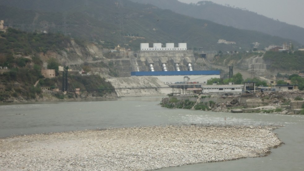
Damaged Vishnuprayag Dam filled with boulders after the June 2013 floods. Source: MATU Jansangathan

In July 2014, it faced another disruption due to the collapse of the 19 metre high and 100 metre long wall of its de-silting basin during a test run of the project[xi]. The heavy rainfall and raging waters in the Alaknanda led to the breaking of the walls which caused flooding and inundation of land and houses. The earlier complaints of the residents of nearby villages regarding the leakage from the power channel canal of the project were not taken seriously by the authorities[xii].

The 171 MW Lata Tapovan project was overrun by floodwaters that damaged concrete work and forced at least a year-long delay in its commissioning. The delay could grow longer because of the badly damaged highway which makes transportation unsafe.

Another affected project is the 520 MW Tapovan Vishnugad  HEP in the Chamoli district. The project was already under scrutiny because of the unfavourable geographical characteristics of the area it is in. The added damage was done during the floods which led to damages in the power channel and the approach road to chormi adit. This could lead to a 12 month delay. Its diversion dyke was also washed away and in June 2014, BHEL refused to start work. Even the head race tunnel (HRT) contractors L&T and Alpine Mayreder Bau Gmbh (AM) have terminated their contract leaving NTPC searching for new contractors[xiii].

The 400 MW Vishnuprayag HEP in the Chamoli district was also affected in the floods as muck and debris filled its reservoir, causing electricity generation to stop. It was also under controversy for being responsible for causing floods downstream as it did not open one of its gates to let the water out, resulting in water finally being left under great pressure causing flooding and destruction of downstream area, people and properties.

Apart from this, the project authorities are also engaging in the disposal of muck and debris on the Alaknanda river bed and not in a safe site. The Jaypee group has been asked to to file a comprehensive affidavit on disposal of river bed material lying in the Vishnupryag HEP on Alakhnanda River, Joshimath by a bench of five judges of the National Green Tribunal. After the floods in 2013, a huge amount of muck and debris were deposited in the reservoir. To clean this and restart electricity generation, the company removed it from the reservoir but dumped it in the Alaknanda river bed, hoping that in the next monsoon it would open its gates enough to let the debris flow downstream. But this is highly dangerous for the downstream areas and population as pointed out by Vimal bhai, founder of the Matu Jansangathan, an NGO[xiv]. The NGT, however, has not taken necessary punitive measures against the company.

Delays:

Contract for construction of the Koteshwar dam was awarded to PCL Intertech Lenhydro Consortium JV in 2002 for a contract value of Rs 334.52 crore. The scheduled completion was specified for May 2006, but project was delayed due to non handling of project and quarry land by the owner to the contractor. Only Rs 99 crore worth work was done upto March 2007[xv].

Another case for delay is the Tehri Pumped Storage Plant (PSP) under the Tehri Hydro Development Corporation (THDC). The contract was given to Alstom-HCC Consortium which had only completed 10% work even after 25 months had elapsed since its commencement and until October 2013[xvi]. Even till April 2014, only 16% of the work was done while only 37 months are left to complete the rest[xvii]. Various problems pointed out by the THDC were that the consortium did not employ sufficient people or deploy enough machinery on site.

The 444 MW Vishnugad-Pipalkoti project under the THDC also faced delays in obtaining the clearances from the forest department to divert 80.507 ha of forest land for the project. The delay was caused in obtaining the stage II forest clearance which was in the hands of the State Wildlife Board, which finally gave its clearance in March 2013. But the surprise is that the World Bank approved the project even before it got its clearances but claimed that work would begin only after all clearances are obtained. But like a lot of other projects, work had already begun for the power house near Harsari village, affecting the villagers. Unfortunately, the inspection panel of the World Bank that was looking into the complaints against the project have completely failed to understand or show the courage to point out the failures of the project and the Bank right from impact assessment to consultations to violations in clearance procedures. The joint statement of the Inspection panel and the World Bank Management on Oct 2, 2014 exposes both the parties. The World Bank, while funding destruction of Alaknanda River, one of the two major head sources of the Ganga, is claiming to fund river rejuvenation efforts in the downstream!

Even one year after the floods, there is no comprehensive report about the disaster that would give a blow by blow account and fix accountability. The villagers are still awaiting resettlement[xviii].

Residents of 29 villages in Tehri district who already faced danger from landslides are now in a worse situation as the landslide occurrence has increased since the 2013 floods. But the villagers say that the state has made no efforts into their relocation and they live in fear of their life. The government had claimed that these villages would be relocated for their safety but due to the laxity of the authorities, work has not started on that yet.[xix]

To know more about the situation of hydropower dams in Uttarakhand in the context of June 2013 disaster, read SANDRP’s blogs:

  1. https://sandrp.wordpress.com/2013/06/21/uttarakhand-deluge-how-human-actions-and-neglect-converted-a-natural-phenomenon-into-a-massive-disaster/
  2. https://sandrp.wordpress.com/2013/06/23/uttarakhand-floods-disaster-lessons-for-himalayan-states/.
  3. https://sandrp.wordpress.com/2013/09/27/uttarakhand-floods-of-june-2013-curtain-raiser-on-the-events-at-nhpcs-280-mw-dhauliganga-hep/
  4. https://sandrp.wordpress.com/2013/04/22/lakhwar-dam-project-why-the-project-should-not-go-ahead/
  5. https://sandrp.wordpress.com/2014/06/16/uttarakhand-flood-disaster-of-june-2013-lest-we-forget-the-experience-and-its-lessons/

Padmakshi Badoni, SANDRP, padmakshi.b@gmail.com


END NOTES:

[i] http://www.eco-business.com/features/india-urged-to-re-think-huge-dam-projects/

[ii]   http://www.business-standard.com/article/current-affairs/uttarakhand-gears-up-for-eco-sensitive-zones-113062400735_1.html

[iii] http://www.climatecentral.org/news/climate-changes-india-floods-18116

[iv] http://www.downtoearth.org.in/content/hydropower-projects-suffer-severe-damage

[v] For details, see: https://sandrp.wordpress.com/2013/08/14/uttarakhand-flood-disaster-supreme-courts-directions-on-uttarakhand-hydropower-projects/

[vi] http://www.deccanherald.com/content/425148/sc-balance-development-environment.html.

[vii] http://www.circleofblue.org/waternews/2014/world/uttarakhand-flood-disaster-made-worse-existing-hydropower-projects-expert-commission-says/

[viii] www.energylineindia.com 30th april 2014.

[ix] http://www.thehindu.com/news/national/other-states/lakhwar-project-in-uttarakhand-gets-environmental-clearance/article5649388.ece

[x] www.energyline.com 8th jan 2013

[xi] http://www.dailypioneer.com/nation/alaknanda-power-projects-basin-wall-collapses.html

[xii] http://www.downtoearth.org.in/content/srinagar-hydroelectric-project-walls-desilting-basin-collapse

[xiii]  www.energylineindia.com june 16, 2014.

[xiv]  matuganga.blogspot.in press note 23-06-14.

[xv] www.energylineindia.com june 4th 2013

[xvi] www.energylineindia.com oct 7th , 2013

[xvii] www.energylineindia.com april 23rd  2014

[xviii] Note: to know more about the damage caused by floods in Uttarakhand, view SANDRP’s film https://sandrp.wordpress.com/2013/12/16/uttarakhand-flood-ravage-and-the-dams-short-film-english/ and https://sandrp.wordpress.com/2013/12/16/uttarakhand-flood-ravage-and-the-dams-short-film-hindi/

[xix] http://www.dailypioneer.com/state-editions/dehradun/fear-of-landslides-haunts-tehri-villagers-awaiting-resettlement.html .

Ganga

World Rivers Day and Ganga: A look at Farakka Barrage and other such calamities

Last Sunday of every September is celebrated as ‘World Rivers Day’. It is a recent phenomenon, but in many senses more significant than World Water Day. While ‘Water’ is seen more as a resource than the life-blood of the global ecosystem, ‘River’ provides water with its ecological, social, cultural and spiritual context. One this day, SANDRP looks at India’s ‘National River’ Ganga. The river seems to be a symbol of all that is right and wrong with water governance in India. It depicts crystallisation of challenges faced by rivers across the country, albeit at a much larger scale. The rich canvass and the deep spiritual value of Ganga for many cultures make it more riveting. The new government at the centre has declared that rejuvenation of the Ganga River is one of its priorities. However, in addition to several infrastructure projects planned and ongoing on the river and its tributaries (Ganga is not just 2525 kms long river, its is more than 25,000 kms long, with all its tributaries), the new Government is planing to build a series of barrages on the River to make it navigable, from Haldia, at the mouth of Hooghly, a major distributary of the Ganga to Allahabad which is some 1620 kms upstream from Haldia. Before we go further into the advantages or the disadvantages of more barrages on Ganga, let us take a look at what one only existing Barrage on this 1620 km stretch of the river, The Farakka Barrage, has done to the river in the past 39 years since the Barrage was commissioned. Let us see how we have managed the issues which have arisen, how human lives have been impacted, what has been our response, how the main objective of building the barrage has been frustrated, how we have dealt with this realization, how the Barrage has furthered more conflicts and how a thriving fishing activity has been nearly killed by Farakka in the upstream as well as in the downstream. SANDRP visited the region of Farakka Barrage, Malda, Murshidabad, talked with the affected people, fisherfolk, authorities at the Barrage as well as the Director and other officials at the Central Inland Fisheries Research Institute (CIFRI) to understand the complex issues. Prior to detailed analysis, here’s looking at Ganga, Hooghly and Farakka in photos.

The Hooghly-Ganga in Kolkata carries 40,000 cusecs water which has been divereted into Hooghly from Ganga at the Farakka Barrage Photo: Parineeta Dandekar, SANDRP
The Hooghly-Ganga in Kolkata carries 40,000 cusecs water which has been diverted into Hooghly from Ganga at the Farakka Barrage Photo: Parineeta Dandekar, SANDRP

Farakka Barrage was commissioned in 1975 to transfer 40,000 cusecs ( Cubic Feet per second) of water from Ganga into its distributary Hooghly to save the Kolkata Port on the Hooghly from silting up. The barrage is just 16 kms upstream from Bangladesh border.

Cargo at Kolkata Port is dropping streadily. The Port is silted up, dredging is ncresing down the years. Farakka Barrage has NOT controlled the silting problem of the Port Photo: The Hindu
Cargo at Kolkata Port is dropping streadily. The Port is silted up, dredging is increasing down the years. Farakka Barrage has NOT controlled the silting problem of the Port Photo: The Hindu
HooghluKol2
Hooghly at Kolkata Photo: Author

As a part of Farakka Barrage Project,  an afflux bund was constructed over several rivers upstream of Farakka, like Choto Bhagirathi, Pagla, etc., to divert water into the Barrage. The complete diversion of water killed these rivers in the downstream, severely affecting people. Here we see Choto Bhagirathi flowing after many years, thanks to a pipeline and sluice sanctioned this year to supply meager water to the river. This does not help the fish though, there are hardly any left.

Meager fishing at Choto Bhagirathi Photo: Author
Choto Bhagirathi, completely diverted for the Farakka Barrage, only flowing this year. Photo: Author
Fishing nets at Choto Bhagirathi. Fisherfolk told   us this was more out of habit, there re hardly any fish left in the river. Photo: Author
Fishing nets at Choto Bhagirathi. Fisherfolk told us this was more out of habit, there are hardly any fish left in the river. Photo: Author
Kedarnath Mondal, a noted activist working on issues related to Farakka Barrge, discussing with fisherfolk
Kedarnath Mondal, a noted activist working on issues related to Farakka Barrge, discussing with fisherfolk. Photo: Author

Not withstanding the anti-erosion works completed upstream the Farakka Barrage in Malda, the Ganga has deposited huge sediment load in the upstream of the barrage and this has accelerated the swing in its channel. The channel is swinging rapidly to the left bank, eroding and eating away thousands of hectares of villages, farms, mango plantations and chars (islands) in the way, endangering the Barrage itself. Although sediment-laden Ganga has a history of changing courses, this has been aggravated to a great extent by the sedimentation and obsrtuction caused by Farakka.

Anti erosion works upstream of Farakka Barrage Photo: Author
Anti Erosion work destroyed
Anti Erosion work destroyed by the river on its left bank, upstream of Barrage Photo: Author
Erosion at Malda upstream Farakka Photo: Soumya Desarkar
Erosion and its impacts Photo: Jaideep Mazoomdar, Outlook

Even before you arrive at the heavily guarded Barrage, you can see the heavily silted river, with cattle grazing peacefully on islands (chars) just 500 meters-1 km upstream of the barrage. According to River Expert Kalyan Rudra, Farakka hordes nearly 350 million tonnes of sediment flow of Ganga every year in the upstream!!

Cattle grazing just upstream of the Barrage, indicating the enormous sediment deposition
Cattle grazing inside the riverbed just upstream of the Barrage, indicating the enormous sediment deposition Photo: Author
Sedimentation upstream the barrage can be clearly seen Photo: Author
Sedimentation inside the riverbed just upstream of  the barrage can be clearly seen Photo: Author
Board proclaiming that Farakka is the Pride of the Nation! Photo: Author
Farakka Barrage
Farakka Barrage Photo: Author
Jpeg
Diversion of water to Farakka Feeder Canal from right bank Photo: Author

The Barrage also severely affected navigation through the river. A separate ship lock was made on the Feeder Canal and it is managed by Inland Waterways Authority of India (IWAI). Hardly any ships pass through due to high sedimentation.

Condition of the Farakka Ship Lock. Secirity Personnel there told us hardly any ships pass this route, less than one ship in three months Photo: Author
Condition of the Farakka Ship Lock. Security personnel posted here told us that hardly any ships pass this route, less than one ship in three months Photo: Author
Hilsa FIshing upstream Farakka is nearly finished as the fish cannot overcome the huge obstacle. Fisherfolk have taken to fishing in the feeder canals where too the catch is meager Photo: Author
Hilsa Fishing upstream Farakka is nearly finished as the fish cannot overcome the huge obstacle. Fisherfolk have taken to fishing in the feeder canals where too the catch is meager Photo: Author
DSC00191
Any meager Hilsa catch is immediately seized by the middleman. In this case middleman gave forty rupees to the fisherman. The Middleman will get more than 300 Rs. for this same catch of Hilsa. Photo Author
Fishermen upstream Farakka are a worried lot

Downstream the barrage, due to trapping of silt in the upstream, silt free water erodes banks with vengeance, especially the left bank. We saw several anti-erosion measures failing miserably in front of the river’s fury.

Anti erosion works get routinely swept away

bankerosion4 Farakka has profoundly changed the character, sediment regime and flow of Ganga. It is affecting lives of lakhs of people in India and Bangladesh through cycles of erosion, sedimentation, floods and affected fishing. Our response to the issue has been dismal. We have not conducted a single review of costs, benefits and impacts of Farakka Project so far. In addition to Farakka , Lower Ganga (Narora), Middle Ganga, Upper Ganga Barrages (Bhimgoda), Kanpur Barrage, Hydropower projects in Uttarakhand and other upstream states have affected the river in most profound ways. If we want to rejuvenate the Ganga, we need to institute a credible independent review the existing Barrages, not plan new ones. May be we can begin with a demand for such a review for Farakka on urgent basis. One World Rivers Day, let us wish for a long and healthy flow for the Ganga River, a symbol of all flowing rivers in India!

-Parineeta Dandekar (parineeta.dandekar@gmail.com)

POST SCRIPT on April 28, 2015:

An edited version of this article and photoessay on The Nowhere People — Environmental Refugees around Farakka, was published in the Mint on March 28th, 2015. Here it is in full: http://www.ficusmedia.com/traildiaries/2015/03/28/the-nowhere-people/
This article was made possible with a grant from The Third Pole and Asia Foundation.
Arati Kumar Rao

Dry Ganga downstream Upper Ganga, Bhimgouda Barrage in Haridwar Photo: Author
Ganga

Ganga and Varanasi’s Waste-water Management: Why has it remained such an Intractable Problem?

Guest blog by: Dr Kelly D. Alley (ALLEYKD@auburn.edu), Auburn University, USA

Varanasi is newsworthy these days, situated symbolically and politically in the new Prime Minister’s agenda. In his victory speech, the PM-elect Narendra Modi vowed to clean the sacred river Ganga. After assuming the office of Prime Minister, he reiterated the vow and pledged renewed efforts for Ganga cleanup.

Three months later, a skeptical Supreme Court reviewed the new government’s Ganga Plan and remarked that with this approach the river will not be cleaned in 200 years. The Supreme Court asked for the full details of the cleanup plan, and inserted its role as a monitor over central government plans. The government has reportedly submitted a new plan to the court, but no details are available yet in the public domain. However, from media reports, it seems the plan is not very different from what has been done in the name of the Ganga Action Plan so far.

As residents and sympathetic outsiders know, the wastewater problem in this sacred, ancient city is seemingly intractable. In order to implement lasting solutions to the recurring river pollution scenario, we need to investigate the current situation. I just completed a field trip to this special city that many call Banaras. I visited all the existing and planned components of the wastewater collection, treatment, and disposal system. In this article I will try to create a visual map of the wastewater infrastructure and management problems and define the current lines of command and control within the vast and overlapping water, environment, and public health bureaucracies. This should help to identify systemic problems in each that need to be addressed when charting a new direction.

The seemingly intractable problems of Ganga clean up (rejuvenation will need so much more than just a clean up) in Banaras can be divided into three categories. First, there are governance problems that are related to how decisions on technologies, scale, operators and siting are made. These include problems with the solicitation, selection, and implementation of projects, especially the design and construction and operation and maintenance of sewers, sewage pumping stations and sewage treatment plants. Second, there are serious infrastructure problems that are part of the complexity of this ancient city.

Third, there is a real electrical power supply problem. Securing continuous electrical power for sewage pumping stations and wastewater treatment facilities is a low priority, and emergency standby generators are not used when the grid-provided power is unavailable.  As a result, the intermittent operation of sewage pumping stations and sewage treatment plants is ineffective in protecting water quality in Ganga and in provisioning safe drinking water and sanitation in Varanasi.

When the sewerage infrastructure is operated intermittently, the treatment technology cannot treat the wastewater adequately, and the concentration of contaminants and water quality indicators such as total suspended sewage solids (TSS) and biological oxygen demand (BOD), heavy metals, toxic organic compounds, and the Most Probable Number (MPN/100ml) of fecal coliform bacteria–indicating the presence of enteric waterborne disease pathogens in the treated effluent–remain high. So in a way providing partial power to a sewage treatment plant does not do the work and is therefore a largely inoperable, non-functional, sunk cost.

Governance

The Government of India established the Ganga Action Plan in 1986 to lead the way in river pollution control programs. In 2009, the Government declared the Ganga a national river and established the National Ganga River Basin Authority. The National Mission Clean Ganga (NMCG)–the implementing agency under this Authority–is now housed in the Ministry of Water Resources, River Development and Ganga Rejuvenation under the Government of India. The Mission Director is the chief executive of the NMCG.

At the state level in Uttar Pradesh, there is a state Project Management Group (PMG) chaired by the Chief Minister. It includes members from the State Ministries of Environment and Irrigation, the Uttar Pradesh Pollution Control Board and the state water commissions. The State PMG decides whom to select for work, and in most cases uses the Uttar Pradesh Jal Nigam (the state level sewage engineers) to execute wastewater project work.

The State PMG can outsource consultancy work and allocate projects to NGOs as well; although in all cases, it has allocated the wastewater engineering work to the Uttar Pradesh Jal Nigam. These layers of committee membership create a vast water bureaucracy at the state level in addition to the committee memberships and officers at the Central level. They are not independent regulators, monitors and compliance officers (which are needed) but contributors and benefactors of political and profitable decisions in the ongoing issuing of contracts, clearances and other approvals.

This is a big problem because any contract for sewerage work must pass through all these departments and boards, with money wasted on bids and approvals for specific projects. In addition there is no other implementing agency in Varanasi so if the UP Jal Nigam’s work is shoddy or even fraudulent, then the Ganga River and the whole city suffers without an alternative. This situation is well known to Banaras residents who will complain daily that funds meant to improve the sewerage system are simply eaten up by various agencies while wastewater is diverted into the sacred river without treatment.

In addition, the foreign donor agency, the Japan International Cooperation Agency or JICA, has been present in Varanasi for many years to advise and assist with capacity building and technological cooperation for the Ganga Action Plan. Apart from controlling the flow of funds, however, it appears that JICA has worked within the current lines of command and control, thereby helping to perpetuate rather than reform the system.

Infrastructure

So what is the current situation with the main wastewater drains? The main drains for the city are the Nagwa drain, located in the south and upstream of the main city, and Khirki nallah, located in the north downstream of the main bathing ghats. The Ganga flows northward at Banaras (see map). The Varuna River enters from the west and circles the outer part of the older sacred city complex before draining into the Ganga at the downstream or northern end. In the last year the Varuna River has turned into a wastewater pond upstream of the barrage recently built under the Puranapul Bridge that crosses the Varuna River. The Varuna river banks downstream of that barrage have also become the dumping grounds for all forms of solid waste and the entire landscape is hellish. One wonders how the communities in the vicinity can survive.

The existing wastewater management facilities include three sewage treatment plants, five sewage pumping stations along the ghats, and one main sewage pumping station at Konia. The Konia pumps are supposed to pump up to 80 million liters of sewage per day to the Dinapur treatment plant located in the trans-Varuna neighborhood of Dinapur village, if they work at full capacity. However they rarely do.

For instance, only one screw pump was working on the day of my visit, so that means it was running at 1/3 its capacity. This would also mean that the Dinapur treatment plant was receiving only 1/3 of the wastewater it is capable of treating, according to its nominal treatment capacity, and therefore it was running at 1/3 capacity. However to be exact one would have to know how many hours the one pump operates each day of the week and then the capacity factor can be calculated. For instance, if the pumping station runs at 1/3 capacity for only 6 of the 24 hours each day then the capacity factor would be 1/12 or about 8%.

If capacity factors of the pumping stations and treatment plants are taken into account in a Life Cycle Cost assessment then the cost per unit volume (ML) of treated sewage would sky rocket.  The UP Jal Nigam does not keep a daily operational log with data like energy usage data, and thus there are no metrics, no measures, and no good management practices. This adds up to a lack of proper governance. Many monitoring committees have made visits to site facilities but have failed to correct the daily malfunctioning of the entire system. On my trip to videotape the Khirki wastewater drain in late June, I said to the boatman taking me, “So they release this water into Ganga ji at night and in early morning, right? Like chup ke?” He replied, “No Madam not chup ke. It is right there running wastewater all the time. Everyone can see it, and they are not even bothering to hide it!”

Below are current pictures of parts of the system that have been damaged, destroyed or poorly maintained. The map can be used to place these pictures in the city space.

Map of main infrastructure facilities in Varanasi


Rajendra Prasad ghat sewage pumping station (one of five ghat pumping stations that send sewage running underground toward the river back to the main trunk line and on to Konia pumping station)
A drain in the western side of Banaras in the unsewered area near the Varuna river. This drain runs to Chauka ghat where the Chauka ghat pumping station is proposed.


The Puranapul bridge with the barrage hidden behind the pillars.
Solid waste dumpsites just downstream of the Puranapul bridge.
A drain in the trans Varuna region.


Khirki Nallah, just upstream from the confluence of the Varuna & Ganga rivers and downstream from the sacred city.


Bhagwanpur sewage treatment plant
Konia sewage pumping station. Only one screw pump is working
Another shot of Konia sewage pumping station with only one screw pump working
Aeration basins at the Dinapur sewage treatment plant
Low efficiency splasher aerators in the aeration basin
Secondary clarifier at the 80 MLD Dinapur sewage treatment plant


Canal taking treated effluent back to the river
Treated wastewater--it looks "clean" but the fecal coliform content is usually in the range of 100,000 MPN/100ml to 1,000,000 MPN/100ml. This is well above safe levels for bathing and human consumption
Treated wastewater–it looks “clean” but the fecal coliform content is usually in the range of 100,000 MPN/100ml to 1,000,000 MPN/100ml. This is well above safe levels for bathing and human consumption
Nagwa wastewater drain, near the confluence of the Assi and Ganga and upstream of Assi ghat and the raw (drinking) water intake point for the city. The non-functioning Nagwa pumping station is in the background
Sewage pipeline damaged by the flood of June 2013 but not repaired. When it was built, it was the pipeline to nowhere. There was no treatment plant constructed at its terminus in Ramana Village along the river bank and upstream of the Nagwa drain

Power

We have to think about wastewater problems in the context of public health, environmental health, electrical power supply and national and state priorities for power distribution. In the current scenario using existing technologies and scales (there are better options for technology and scale), a significant amount of energy is required to pump and treat wastewater using sewage pumping stations and the activated sludge treatment process. In India energy supplies are allocated to industrial and urban needs long before they are distributed to sewage treatment plants. Looking at the current energy scenario in India it is not hard to see that wastewater pumping and treatment require continuous power and are not sustainable in the context of the current power deficit. Biological secondary treatment using the Activated Sludge Process (ASP) uses a significant amount of electricity to operate aeration equipment and mixers. Another technology used in Kanpur, the Upflow Anaerobic Sludge Blanket (UASB), is also a capital and energy intensive process. With other demands high on the agenda, it is unlikely that precious power will be available to run all the existing and proposed sewage pumping stations and sewage treatment plants on a daily basis now and into the future if the existing technologies and scales continue to be used.

Take Away Points

If wastewater infrastructure is built, it is done with large government investments of public funds, sometimes with capital from international banks; there is little private equity to drive the process. Instead the costs of building (and also poorly building) these facilities are absorbed across a range of human services including public health, education, housing and infrastructure. The costs of operating and maintaining sewage pumping stations and treatment plants are also high and operation and maintenance of the facilities become a low priority after construction.

For instance, the sewage treatment plant laboratories are ill-equipped and this means that the UP Jal Nigam operators are unable to monitor, measure, and report operational and water quality data. Due to the absence of laboratory equipment, instruments and analytical capacity, they are not able to optimize the treatment process. Generally the functional components of the sewerage infrastructure – the sewage pumping stations and treatment plants – are overwhelmed by the dysfunctional components and by the enormous pollution load. In this way the functioning units in the system become important, not for effectively treating the waste but for projecting a façade of functional infrastructure, especially when site visits by monitoring agencies are underway. Yet the norm is that facilities are operated only periodically and usually below capacity, and the result is that untreated wastewater is passed through open drains to agricultural fields or rivers. During rains and the monsoon, wastewater combined with storm water flows directly into the Assi, Varuna, and Ganga Rivers.

This sacred city requires a competent participatory authority to master plan, design, select the right scales and technology, construct, operate and effectively maintain a comprehensive wastewater collection, treatment and reuse system. Its governance requires clearly defined norms of transparency, accountability and participation.

A competent authority should connect central, state and municipal levels and be accountable to the residents of the city not just through the municipal corporation and its elected officials, but also directly through norms of participatory governance. These governance reforms should include clearly defined norms of transparency, accountability and participation that pertain to the entire system and to each component part–the pumping stations, sewage and water treatment plants, sewers and associated facilities. A piecemeal approach with the Jal Nigam exclusively at the helm has not worked thus far and it has sunk crores of rupees into poorly operated and maintained infrastructure, even in the face of national and global attention and numerous judicial interventions to the cause of Ganga cleanup. A careful constitution of accountable engineering agencies, a welcoming approach in planning and implementation to citizen contributions, and a vigilant monitoring of operations and maintenance practices by concerned citizen groups can go a long way to reforming the system. There is no doubt that this cause runs deep in the hearts of every Banaras resident.

[For PDF file containing this blog, see: https://sandrp.in/otherissues/Varanasi_Ganga_Wastewater_Management.pdf.]

Additional Information:

1) Video of the run off coming through the Rajendra Prasad ghat pumping station after a heavy rain in June 2014: https://www.youtube.com/watch?v=ujBB2FLYkZM

2) Video of Khirki Nallah in June 2014: https://www.youtube.com/watch?v=S0KUXEw7DRg

3) Video of Nagwa Nallah in June 2014:

https://www.youtube.com/watch?v=7xraLNjdPg4&feature=youtu.be

4) POST SCRIPT For further reading: http://www.thethirdpole.net/2015/11/06/tibet-dams-hold-back-silt-not-water

Ganga · Mithi · Mumbai · Narmada · Sabarmati

Riverfront Development in India: Cosmetic make up on deep wounds


There is a rush of riverfront development schemes in India. We have heard of Sabarmati Riverfront development being drummed many times, followed by the proposed rejuvenation of Ganga, supposedly on the lines of Sabarmati.

What does Riverfront Development entail? Is it River Restoration? Are the millions of rupees spent on Riverfront Development schemes justified? Will it help in saving our damaged rivers?

A cursory glance at the existing river restoration/ improvement/beautification schemes indicates that the discourse revolves mainly around recreational and commercial activities. It is more about real estate than river. Activities that are promoted on the riverfronts typically include promenades, boat trips, shopping, petty shops, restaurants, theme parks, walk ways and even parking lots in the encroached river bed.

Riverfont 1

Pioneering project in Riverfront Development was claimed to be the Sabarmati Riverfront Development project of Ahmedabad city which was supposed to be designed based on riverfronts of Thames in London and Seine in Paris. The project which began as an urban development project is lately being pushed as a role model for many urban rivers in India. This kind of riverfront development essentially changes the ecological and social scape of the river transforming it into an urban commercial space rather than a natural, social, cultural, ecological landscape. Is it wise to go for this kind of development on riverfronts? What does it do to the river ecosystem, its hydrological cycle? What does it do to the downstream of river? These questions need to be explored before accepting the current model of riverfront development as replicable or laudable.

Reclaim and beautify!

Most of the currently ongoing projects lay a heavy emphasis on beautification of rivers. Riverfronts are treated as extension of urban spaces and are often conceived as ‘vibrant’, ‘throbbing’ or ‘breathing’ spaces by the designers. Concrete Wall Embankments, reclamation of the riverine floodplains and commercialization of the reclaimed land are the innate components of these projects. Quick glimpse at various Riverfront Development Projects confirms this.

Sabarmati Riverfront Development Project

Sabarmati Riverfront Development Project of Ahmedabad city which is presented as a pioneer in urban transformation[1] has been proposed by Environmental Planning Collaborative (EPC), an Ahmedabad-based urban planning consultancy firm, in 1997 and envisaged to develop a stretch of 10.4 km of the banks on both sides of the river by creating concrete embankment walls on both banks with walkways. A Special Purpose Vehicle called the Sabarmati Riverfront Development Corporation Ltd. (SRFDCL) was formed in the same year for implementation of the project. The financial cost of the initiative was estimated to be in the range of around INR 11520 million[2]. Around two thirds of this amount has already been spent.

Construction of the project started in 2005. The project sought to develop the riverfront on either side of the Sabarmati for 10.4 kms by constructing embankments and roads, laying water supply lines and trunk sewers, building pumping stations, and developing gardens and promenades[3]. Mainstay of the project was the sale of riverfront property. Land along the 10.4 km stretch on both the banks was reclaimed by constructing retaining walls of height ranging from 4 to 6m[4]. 21% of the 185 ha of reclaimed land which was developed by concretizing the river bank[5] was sold to private developers for commercial purpose.[6] Activities hosted on this reclaimed land were recreational and commercial activities like restaurants, shops, waterfront settlements, gardens, walkways, amusement parks, golf course, water sports and some for public purpose like roads etc. The sale of reclaimed land created by the project is expected to cover the full cost of the project. Ahmedabad Municipal Corporation (AMC) claims that the after the project “river has added vibrancy to the urban landscape of Ahmadabad with its open spaces, walkways, well-designed gardens along with activities which contribute to economic growth.”[7]

Even though the project has been modeled as “best practice” by several financing institutions[8], it has also drawn severe criticism for poor rehabilitation of the displaced (rehabilitation happened only after High Court orders following a public interest petition) disrupting the nexus of shelter, livelihood and services of urban poor, lack of transparency in the execution and for tampering with the carrying capacity of the river. No Environment Impact Assessment of the project has been conducted nor any credible public consultation process held.

Sabarmati channel has been uniformly narrowed to 275 metres during the riverfront development project, when naturally average width of the channel was 382 metres and the narrowest cross-section was 330 metres[9]. In this attempt of “pinching the river”[10], the original character of the river is changed completely from seasonally flowing river to an impounded tank illegally taking water from Narmada Canal[11]. River banks have been treated as land that is wasted on which value could be created by reclaiming and not as seasonal ecological systems with floodplains as an integral part of its flows (Baviskar 2011). Seasonality of the river is destroyed and fauna and avi fauna on edges have been damaged. No thought has been given for protection, sustenance or enhancement of the riverine ecosystem. The water that is now impounded in this stretch is not even Sabarmati river water, but Narmada River Water, on which the city of Ahmedabad or Sabarmati has no right, it’s the water meant for drought prone areas of Kutch, Saurashtra and North Gujarat.

The River Sabarmati itself was a perennial river till the Dharoi Dam in the upstream stopped all water at least in non Monsoon months, making the river dry. The stretch flowing through Ahmedabad was carrying the mostly untreated sewage of Ahmedabad city and toxic effluents from the City and district industries.

In the name of Sabarmati River front development, no cleaning of the river has happened, the project has only transferred the water from both banks to the river downstream from Vasna barrage, which is situated downstream from the city. The Vasna barrage stops and stores the water released from Narmada Main Canal that crosses the river about 10.4 km upstream from the barrage. Thus this 10.4 km stretch of the river now holds the Narmada water and huge losses from the stretch are losses for the drought prone areas.

Riverfont 3

The reclaimed land and the narrowing of the channel have been tampering with the carrying capacity of the river. The project was stalled during August 2006 to March 2007 due to heavy floods[12]. Prior to the floods, the river’s maximum carrying capacity was calculated at 4.75 lakh cusecs on basis of the rainfall over last 100 years[13]. The floods however proved the calculation wrong. National Institute of Hydrology (NIH) and Indian Institute of Technology Roorkee (IITR) were asked to re-evaluate the project design, in the light of the river’s carrying capacity, and see whether the execution of the project would damage the river’s ecology[14]. Report by the NIH, Roorkee in 2007 said “the calculations did not take into account any simultaneous rainfall over the entire catchment area”[15]. This means that the carrying capacity was based only on the water flow from the Dharoi Dam (which is upstream of Ahmedabad City) and not from other places in the river’s catchment until Ahmedabad that also contribute to the volume of water in the Sabarmati. This report states that the riverfront development is “not a flood control scheme”, and that the municipal corporation will have to work out other measures to meet the impending challenge of floods.

The project is also heavily criticized for the poor rehabilitation of the evicted slum population. Large scale eviction was being carried out in an utmost non-transparent manner. A public interest litigation (PIL) was filed in the Gujarat High Court by Sabarmati Nagarik Adhikar Manch (SNAM) or Sabarmati Citizens Rights Forum, supported by several other non-governmental organisations (NGOs) to ensure that the rehabilitation plan was shared with them and to bring transparency to the process. According to the high court orders, at least 11,000 affected families were to be rehabilitated and resettled by AMC. Demolition drive went on without ensuring rehabilitation. Over 3,000 people have moved to a marshland in the outskirts of city with negligible compensation, little & infrequent access to drinking water and minimal sanitation facilities[16].

“The ecology of the river is being transformed to satisfy the commercial greed of a select few,” said Darshni Mahadevia of CEPT, expressing concerns about riverfront ‘beautification’[17].

The project that has converted the Sabarmati River into an urban space by reclaiming nearly 200 ha of land and has sustained by borrowing water from Narmada Canal today is claimed to be a role model for many riverfront development projects in the country. Should this model really be replicated? Many of the rivers like Yamuna, Ganga, Mithi, Brahmaputra etc. that are being ‘developed’, have had a flood history which is being ignored in the process. With having no regards to the hazards of floods, several riverfront projects are being pushed across the country by different government agencies.

The fact that even after a Riverfront Development Project, Water Quality of Sabarmati downstream the Vasna Barrage is extremely poor and the cosmetic treatment of flowing water stretch at Ahmedabad is actually water from Narmada, which was promised for the drought hit regions of Kutch and Saurashtra, highlights the contradictory and superficial nature of such Riverfront development schemes.

Yamuna Riverfront Development inspired from Sabarmati Model

Recently the newly elected BJP led Central Government sent a team of bureaucrats to Gujarat to study the feasibility of replicating the successful model of the Sabarmati Riverfront Development Project for cleaning the Yamuna[18]. Despite the concerns about flooding of Yamuna, the team is exploring ways of replicating Sabarmati Model. In 2009, the Sheila Dikshit administration was also planning channelizing the Yamuna and putting up a waterfront like Paris and London with recreational facilities, parking lots and promenades etc[19].

Reclamation of the floodplains to create a concrete riverfront, like in Ahmedabad, could be ecologically unsound and even dangerous for Delhi that is already extremely vulnerable to floods[20]. The sediment load in Yamuna is very high. The non-channelized river rises by over four metres during peak monsoon flooding[21]. Risk of flooding will increase multifold for a channelized river. The Inter-governmental Panel on Climate Change last year put Delhi among three world cities at high risk of floods. Tokyo and Shanghai are the two other cities.

An expert committee appointed by the Ministry of Environment & Forests (MoEF) to examine the Yamuna River Front Development Scheme of the Delhi Development Authority (DDA) recommended that DDA should scrap its ambitious plan for developing recreational facilities, parking lots and promenades. [22] The committee was formed following order from National Green Tribunal which was drawn in response to a petition filed by activists and Yamuna Jiye Abhiyaan convener Manoj Misra.[23] The committee pointed out that recreational spots located in active floodplain areas would kill the river and cause floods in the city. About the Sabarmati Model Being followed, CR Babu, Chair of the committee said: “There is no Sabarmati river. It’s stagnant water with concrete walls on two sides. The floodplains have been concretized to make pathways and real estate projects. It cannot be replicated for our Yamuna”.

The committee report says the Yamuna Riverfront Development scheme will reduce the river’s flood-carrying capacity and increase flooding and pollution and it recommended a ban on developmental activity in the river’s Zone ‘O’ and its active floodplains on the Uttar Pradesh side. It also said that a 52-km stretch of the Yamuna in Delhi and Uttar Pradesh be declared a ‘conservation zone’ as restoring the river’s ecological functions is heavily dependent on the environmental flow through this stretch, particularly in the lean season.

Manoj Misra of Yamuna Jiye Abhiyan, dismisses the Sabarmati solution saying “We cannot call it a Sabarmati model… It’s like a mirage created for a brief stretch. Let’s be clear about it. If the Delhi bureaucrats have gone there to learn from the Gujarat model, it’s up to them to figure out if it can be implemented. I cannot call the Sabarmati project a river rejuvenation project – it’s more of a real estate project… That is not advisable for Delhi.” [24]

Another important aspect which does not feature at all during the talks of Yamuna Riverfront Development is the massive displacement that will take place. Over a dozen unauthorised colonies are located on the riverbed. These colonies which have been in existence for over 40 years will have to be uprooted which again may lead to Sabarmati like situation where urban poor are brushed aside to serve interests of real estate developers and urban middle class.[25]

Riverfont 4

City of Noida on the other hand has decided to go ahead with the Rs 200 crore Yamuna Riverfront Development Project that Greater Noida Authority (GNA) has been planning[26]. The project involves developing recreational facilities like parks, Yoga centres, picnic spots and sports centres, polo grounds, golf course etc. on Hindon and Yamuna floodplains. Officials from GNA claim that these facilities will be for recreational purpose and will be developed without disrupting the natural flow of Yamuna. Here again the project has nothing to do with sustaining, cleaning, rejuvenation of the river.

Ganga cannot be ‘developed’ as Sabarmati

Prime Minister Narendra Modi made a promise during his election campaign in Varanasi to clean up Ganga.[27] The National Ganga River Basin Authority (NGRBA) was shifted from the environment ministry to the water resources ministry.[28] New name for the Ministry of Water Resources is Ministry of Water Resources, River Development and Ganga Rejuvenation. Uma Bharati was assigned with this specially created ministry for cleaning Ganga by the PM. “If Sabarmati can be cleaned, all other rivers can also be made better.” print media has quoted Uma Bharati.[29] Ms Uma Bharati seems to have no idea that Sabarmati has NOT been cleaned, the Sabarmati project just transferred the polluted water downstream of the 10.4 km stretch. Can Sabarmati Model be replicated at Ganga? Even if it is replicated, will it help the cause or river or river rejuvenation? The answer is clearly a BIG NO. A number of apprehensions have been raised in this regard. “The so-called Sabarmati model won’t work for the Ganga. The Sabarmati has neither been cleaned nor rejuvenated,” Openindia News quotes Himanshu Thakkar, environmentalist and coordinator of SANDRP[30]. He further points out that
Sabarmati Model survives on water from Narmada canal in the stretch of 10.4 km which flows through the Ahmedabad city. This is not possible in case of Ganga.

Priority for the river rejuvenation is restoring its water quality, freshwater flow and not riverbank beautification. More than Rs. 5,000 crore (some estimates this figure to be over Rs 20 000 crores) has been spent on cleaning the Ganga in the past 28 years. The Ganga Action Plan was launched in 1986 and was in 1994 extended to the Yamuna, Gomti and other tributaries of the Ganga. The second phase of the Ganga Action Plan was launched in 2000 and NGRBA was created in 2009.[31] The plan however has not achieved what it set out to achieve. Water quality for Ganga River has been declining and is unfit even for irrigation or bathing. Potable use is out of question. The count of harmful organisms, including hazardous faecal bacteria, at many locations is more than 100 times the limit set by the government. The water’s biochemical oxygen content, which is vital for the survival of aquatic wildlife, has dipped drastically.[32] Any “cosmetic treatments”[33] will not work for Ganga, like they have not worked for Sabarmati.

Several Riverfront Development Projects springing up across nation

While there are experts opposing replication of Sabarmati Riverfront Project on Ganga and Yamuna River, there are several other riverfront projects which are inspired by the Sabarmati Project and which are being pushed without any kind of studies or impact assessment. Their possible impacts on the riverine ecology, flood patterns, downstream areas etc. are going unchecked.

Brahmaputra Riverfront Development Project: Another “multi-dimensional environment improvement and urban rejuvenation project” that is set to come up with plans for reclaimed river banks is on Brahmaputra River in Guwahati[34]. While on one hand the city is struggling to cope up with the flood prone nature of the Brahmaputra River, State Government of Assam plans to take up an ambitious project to develop the city riverfront named ‘Brahmaputra Riverfront Development Project’ under the Assam Infrastructure Financing Authority. The riverfront project will be implemented by the Guwahati Metropolitan Development Authority (GMDA) in phases[35]. Foundation of the beautification project was laid by the Chief Minister Tarun Gogoi in February 2013. The project plans to achieve maximum possible reclamation[36].While the plan talks of revitalization of the river ecology and Strengthening of riverbanks through soil bio engineering it has several urban features on its agenda like promenade, Ghats, Plazas and Parks; buildings, conference facilities, Parking lots, ferry terminals, Bus and para transport stops, Urban utilities and drainage, Improved infrastructure for floating restaurants, Public amenities; Dhobi Ghats, etc.[37]

Will such a huge real estate development leave any room for river or its revitalization?

Tendency to flood is an important feature of River Brahmaputra. The river also has one of the highest sediment loads in the world. Every year during the successive floods, most of the areas in the valley of Assam remain submerged for a considerable numbers of days causing wide spread damages. In a phenomenon as recent as June 27, 2014 Guwahati experienced heavy downpour for 15 hours, setting off flash floods[38]. Half of the city was submerged under flood water. The authorities blamed illegal encroachments on watersheds across the state capital for the flash floods, which had choked the natural outlets for the gushing water. National Institute of Hydrology (NIH), Roorkee; upon being requested by the GMDA; is carrying out a study which includes river shifting analysis for studying stability of the river banks, flow variations to determine the perennial water depth, estimate of floods of various return periods for design of river embankments, estimate of water surface profiles employing hydro-dynamic river flow model and design parameters for river embankments[39]. The Bramhaputra Riverfront Development Project however has been inaugurated even before the requisite studies have been completed.

Riverfont 5

Gomti Riverfront Development Project in Lucknow: The project by the Lucknow Development Authority is based on the Sabarmati Riverfront Model. It plans to “beautify” Gomti River between Gomti Barrage and Bridge on Bye-pass road connecting Lucknow-Hardoi road and Lucknow-Sitapur road, a length of about 15 Km. According to the Technical Bid Document released by the Lucknow Development Authority, the Riverfront Project has no component of water treatment or river restoration, but is a landscape-based development project, which will also look at “reclaiming” the river banks for activities like shops, entertainment area, promenades, etc. The inspiration for the project swings from Thames Rivefront in London, to Sabarmati in Gujarat, depending on the political party in power.[40]

In all this discussion, there is no mention of maintaining adequate flow in Gomti, treating sewage, conserving its floodplains, or any other ecological angles.

River Improvement and Restoration are also about real estate!

For many government agencies, ironically, not just river beautification, but the idea of river improvement and restoration is also about channelizing rivers and providing recreational facilities.

Pune Rivefront Project: Pune Municipal Corporation, the Pune city also known for chronically polluting Mula and Mutha rivers that flow through the heart of the city, has sanctioned a River Improvement Project, under the aegis of JNNURM (Jawaharlal Nehru National Urban Renewal Mission). The Project envisages channelizing the river, introducing barrages to maintain water levels, development of riparian zone as entertainment and shopping groups, even Parking lots, introducing navigation in the river etc. There are several issues with this “improvement” project. Firstly, it is not planned according to the once in a hundred years flood in Pune, it plans to constrict the river further, thus encroaching the riverbed. Creation of stagnant pools through barrages will result in backwater effect on the many nallahs that join the river. These Nallahs routinely flood in rainy season and additional backwater in these nallahs will worsen the situation further. The project does not say a word about treating water quality, but envisages to build drainage lines inside the riverbed and carry the sewage out of Pune city limits. This hardly qualifies as river rejuvenation or restoration. A case has been filed against this project in National Green Tribunal.

Goda Park (Godavari Riverfront Project) in Nashik, Maharashtra: Godavari emerging from the Brahmagiri Hills in Nashik is famed not only for being one of the longest rivers in India, but also because Kumbh Mela is held on its banks every 12 years in Nashik. Nashik and Trimbakeshwar have had no dearth of funding for cleaning Godavari. They have received funds from the National River Conservation Directorate as well as JNNURM. Despite this, Godavari is extremely filthy in Nashik. Ignoring the pressing issues of water quality, Nashik Municipal Corporation and a specific political party have been hankering after beatification of Godavari’s banks. In fact, the project has been handed over to Reliance Foundation by the Nashik Municipal Corporation[41] without any public consultations or discussions. As per reports, the components of this 13.5 kms long project will be laser shows, musical fountains, rope-way, multi-purpose meeting hall, garden, water sports, canteen, etc.[42]

In the meantime, there are several court orders against Nashik Municipal Corporation pending about severe water pollution in the River including Ram Kund where holy dip on Kumbh Mela is supposed to be taken.

Mithi Riverfront Development: Stretch of 18 km of Mithi River flows through city of Mumbai. Course of Mithi has been modified throughout the city to host range of activities.[43] On 26 July 2005, the river flooded some of the most densely populated areas claiming nearly 1000 lives[44].

After these catastrophic floods, the Municipal Corporation of Greater Mumbai (MCGM) and Mumbai Metropolitan Region Development Authority (MMRDA) made a plan to “restore” the river. BMC and MMRDA’s definition of restoration involves desilting, beautification and building of a retaining wall. Stretch of 4.5 km of the total six km stretch of the river that falls within MMRDA’s jurisdiction is covered with mangroves. MMRDA has planned to beautify the stretch of remaining 1.5 km (10 Ha) which lies right amidst mangroves by developing a promenade. MMRDA plans developing this project on a PPP (Public Private Partnership) basis. Interestingly, the Mukesh Ambani-led Reliance Foundation and Standard Chartered bank have been selected for this project.[45]

As per the Coastal Zone Management Plan (CZMP) of the area, the proposed Mithi Riverfront Development Project falls in Coastal Regulation Zone (CRZ) II and III. The proposal was presented to CRZ authority in its 82nd meeting on 10th June, 2013[46]. CRZ authority has not allowed any reclamation or construction activities in this stretch. For Widening, lengthening & reconstruction of the existing bridge CRZ has referred the proposal to MoEF and asked MMRDA to take prior permission of High Court if the proposal involves destruction of mangroves[47].

Observer Research Foundation, a private, not for profit organization (funded by Reliance India[48]) from Mumbai has come up with a study that recommends a 21-point programme for reclaiming the Mithi, envisaging a single and unbroken river-park corridor spanning across the entire 18-km length of the Mithi with dedicated bicycle tracks, gardens, amphitheatres, sports and recreation.[49]

Riverfont 6

Riverfront Development is NOT River Restoration

As is evident, the riverfront projects discussed above are essentially river bank beautification & Real Estate Development projects and not helping restoration of the river. The projects aim at comodifying rivers to develop urban scapes. Such riverfront development changes the essential character of the river. Stream channelization and alteration of shoreline disconnects the river stretch from adjacent ecosystems and leads to risks of habitat degradation, changes in the flow regime and siltation[50].

While the water of the rivers flows in the natural landscapes, there are many processes that are happening. Sediments are carried, fertile land is created along the banks, river channel is widened, flooding, deposition of sediments during flooding, cleansing of river etc.[51] However the urban rivers are alienated from this natural landscape to such an extent that the rivers are reduced to merely nallas carrying city’s sewage and filth.

Flow, connectivity and flood are fundamental characteristics of rivers and rivers need space for that. If these are violated the river water spreads uncontrolled through the habitation causing catastrophic events like Mithi Flooding.

Creating more room for rivers

While Indian cities are busy replicating Riverfronts of Thames and Seine, there are some remarkable projects going on in some other countries which actually talk of giving more room to the rivers during floods. They are trying to restore the river and not beautify, concretize, channelise or encroach on it.

In the Netherlands, such an integrated approach has been adopted for ‘Room for the River Program’[52]. The program is currently being implemented in the Dutch Rhine River Basin of the country.

The programme started in 2006 is scheduled to be completed by 2015. The objectives of the programme are improving safety against flooding of riverine areas of Rivers Rhine and Meuse by increasing the discharge capacity and improving of spatial quality of the riverine area.

At 39 locations, measures will be taken to give the river space to flood safely through flood bypasses, excavation of flood plains, dike relocation and lowering of groynes etc. Moreover, the measures will be designed in such a way that they improve the quality of the immediate surroundings.

While Room for the River programme focuses on flood management in sustainable way, Yolo Bypass is another unique initiative aimed at keeping intact the benefits to the ecosystem without causing a negative impact on water supply[53]. The Yolo Bypass is a flood bypass in the Sacramento Valley located in Yolo and Solano Counties of California State in USA. The primary function of the bypass is flood damage reduction. It is a designated floodway that encompasses 60,000 acres in eastern Yolo County between the cities of Davis and Sacramento. All the properties within the bypass are subject to a flood easement that allows the state to flood the land for public safety and ecological benefit.

Conclusion

Riverfront of Thames in London and Seine in Paris are often cited as successful models of riverfront development in India. However, the ecological as well as social setting of Indian rivers and the challenges that we face are significantly different from these foreign models. A Blind replication will only be wastage of public funds and degradation of the rivers further. Riverfront development projects across the country seem to be alienated from the river, and talk only about its urban banks, trying to achieve cosmetic changes on deeper wounds by encroachment and real estate development on the belly of the rivers. The need of the hour is river rejuvenation and not river FRONT development. Let us hope that we see central place for rivers in all these projects. Moreover, there is neither any social or environmental impact assessment, nor any regulation or democratic participatory decision making process. Such projects will only be at the cost of the poor, the environment, future generation and to short term benefits of real estate developers and a section of urban middle class.

Amruta Pradhan, SANDRP (With Inputs from Himanshu Thakkar & Parineeta Dandekar)

amrutapradhan@gmail.com

An edited version of this article has been published at: http://indiatogether.org/gujarat-sabarmati-riverfront-development-model-for-ganga-yamuna-environment

END NOTES:

[1] http://www.egovamc.com/SRFDCL/SRFDCL.pdf

[2] http://www.egovamc.com/SRFDCL/SRFDCL.pdf

[3] http://www.frontline.in/static/html/fl2802/stories/20110128280208500.htm

[4] http://www.frontline.in/static/html/fl2802/stories/20110128280208500.htm

[5]http://www.business-standard.com/article/current-affairs/amc-bets-on-huge-returns-from-riverfront-property-sale-114032000894_1.html

[6] http://indiaenvironmentportal.org.in/files/file/Sabarmati%20Riverfront.pdf

[7] http://www.egovamc.com/SRFDCL/SRFDCL.pdf

[8] http://indiaenvironmentportal.org.in/files/file/Sabarmati%20Riverfront.pdf

[9] http://www.downtoearth.org.in/node/5786

[10] http://www.frontline.in/static/html/fl2802/stories/20110128280208500.htm

[11] http://landscapeindiapbb.wordpress.com/2013/10/30/riverfront-development-ahmedabad/

[12] http://www.downtoearth.org.in/node/5786

[13] http://archive.indianexpress.com/news/flood-control-in-sabarmati-a-challenge-for-amc/654704/

[14] http://www.downtoearth.org.in/node/5786

[15] http://archive.indianexpress.com/news/flood-control-in-sabarmati-a-challenge-for-amc/654704/

[16] http://indiaenvironmentportal.org.in/files/file/Sabarmati%20Riverfront.pdf

[17] http://www.downtoearth.org.in/node/5786

[18] http://timesofindia.indiatimes.com/city/delhi/Delhi-babu-all-praise-for-Sabarmati-plan/articleshow/36363896.cms

[19] http://timesofindia.indiatimes.com/city/delhi/Scientist-cautions-against-riverfront-plan/articleshow/38500711.cms

[20]http://timesofindia.indiatimes.com/city/delhi/River-experts-say-Sabarmati-no-model-for-Yamuna/articleshow/36222968.cms

[21] http://timesofindia.indiatimes.com/city/delhi/Scientist-cautions-against-riverfront-plan/articleshow/38500711.cms

[22]http://timesofindia.indiatimes.com/city/delhi/Scientist-opposes-Sabarmati-model-says-reclaiming-floodplain-not-a-good-idea-for-Yamuna/articleshow/36679502.cms

[23] http://www.newindianexpress.com/nation/Yamuna-Action-Plan-Soon-Promises-MoEF/2013/12/19/article1953318.ece,

http://www.indiaenvironmentportal.org.in/files/Yamuna%20River%20Front%20NGT%2018Dec2013.pdf

[24]http://timesofindia.indiatimes.com/city/delhi/River-experts-say-Sabarmati-no-model-for-Yamuna/articleshow/36222968.cms

[25] http://www.asianage.com/delhi/illegal-colonies-near-river-may-be-shifted-946

[26] http://timesofindia.indiatimes.com/city/noida/Twin-cities-to-go-ahead-with-riverfront-project/articleshow/34845006.cms

[27] http://indianexpress.com/article/india/politics/modi-assigns-task-of-cleaning-ganga-to-uma-bharti/,

http://www.firstpost.com/politics/cleaning-up-the-ganga-yamuna-why-modi-must-forget-sabarmati-model-1560939.html

[28]http://www.hindustantimes.com/india-news/clean-up-act-superbody-headed-by-pm-modi-to-drive-mission-ganga/article1-1253158.aspx

[29] http://www.firstpost.com/politics/cleaning-up-the-ganga-yamuna-why-modi-must-forget-sabarmati-model-1560939.html

[30] http://news.oneindia.in/india/sabarmati-model-not-enough-for-ganga-1478033.html

[31] http://news.oneindia.in/india/sabarmati-model-not-enough-for-ganga-1478033.html

[32] http://www.business-standard.com/article/opinion/rejuvenating-a-river-114052801804_1.html

[33] http://www.business-standard.com/article/opinion/rejuvenating-a-river-114052801804_1.html

[34] http://www.assamtribune.com/scripts/detailsnew.asp?id=aug3113/city05

[35] http://guwahatilife.blogspot.in/2011/02/cm-lays-foundation-of-beautification-of.html

[36] http://www.assamtribune.com/scripts/detailsnew.asp?id=aug3113/city05

[37] http://www.psda.in/guwahati.asp

[38] http://www.ndtv.com/article/india/flash-floods-in-guwahati-seven-dead-in-last-15-hours-548974

[39] http://www.assamtribune.com/scripts/detailsnew.asp?id=aug3113/city05

[40]http://timesofindia.indiatimes.com/city/lucknow/Lucknow-Development-Authority-to-get-new-blueprint-of-Gomti-riverfront-development-project/articleshow/19687344.cms

http://m.financialexpress.com/news/akhilesh-wants-london-eye-in-lucknow/975999/

[41] http://www.reliancefoundation.org/urban_renewal.html

[42]http://articles.economictimes.indiatimes.com/2013-09-20/news/42252355_1_goda-park-project-reliance-foundation-mns-chief-raj-thackeray

[43] The Mumbai airport has its domestic and international terminals, and its cargo complex along the Mithi River. There are five major railway stations along the Mithi River including Mahim and Bandra on the western line andSion, Chunnabhatti and Kurla on the central line. The upcoming V ersova-Andheri-Ghatkopar corridor of the Mumbai Metro project that also crosses over the Mithi River has two stations planned along the Mithi River at Marol and Saki Naka. There are also several bus stops located close to the river all along its banks.

(Source: http://orfonline.org/cms/sites/orfonline/modules/report/ReportDetail.html?cmaid=23400&mmacmaid=23401)

[44] http://orfonline.org/cms/sites/orfonline/modules/report/ReportDetail.html?cmaid=23400&mmacmaid=23401

[45] http://indianexpress.com/article/cities/mumbai/beautification-plans-of-mithi-river-promenade-stuck-over-crz-norms/

[46] https://mczma.maharashtra.gov.in/pdf/MCZMA_MoM82.pdf

[47] The proposal was cleared subject to compliance of following conditions

(i) The proposed construction should be carried out strictly as per the provisions of CRZ Notification, 2011 (as amended from time to time) and guidelines/ clarifications given by MoEF time to time.

(ii) Disposal of debris during construction phase should be as per MSW (M&H) rules. 2000.

(iii) Tidal flow of river should not be obstructed.

(iv) The project proponent should obtain prior High Court permission, if the proposal involves destruction of mangroves or construction falls with 50 nil buffer zone.

(v) All other required permissions from different statutory authorities should be obtained prior to commencement of work

[48] http://www.rediff.com/news/report/najeeb-jung-the-man-who-may-run-delhi/20131213.htm

[49]http://www.indiawaterportal.org/sites/indiawaterportal.org/files/why_mumbai_must_reclaim_its_mithi_gautam_kirtane_orf_2011.pdf

[50] http://water.epa.gov/type/wetlands/restore/principles.cfm

[51] Nature Conservation by Ketki Ghate, Manasi Karandikar

[52] http://www.downtoearth.org.in/node/5786

[53] http://www.americanrivers.org/initiative/floods/projects/yolo-bypass-and-the-fremont-weir/

Chenab · Floods · Jammu and Kashmir

Why does Central Water Commission have no flood forecasting for Jammu & Kashmir? Why this neglect by Central Government?

During Sept 4-6, 2014 Jammu and Kashmir in North India is facing one of the worst floods. NDTV[1] has reported that these are the worst floods in 60 years (The Times of India reported that this was worst flood of the state since independence based on number of casualties.). More than 160 people have died and some 2500 villages are affected (1615 in the valley, rest in Jammu), out of which 450 are completely submerged (390 in valley)[2]. Over 10 000 people are stranded across the state. The flood has affected almost all 10 districts in the Jammu region. J&K Chief Minister admitted that the rescuers have yet to reach the worst affected South Kashmir region. Jammu Srinagar Highway has remained blocked for over three days. Several rivers have been flowing above the danger mark and most parts of south Kashmir, including Pulwama, Anantnag and Kulgam districts have been submerged. Jhelum was flowing at 30.7 ft in South Kashmir, 7 ft above the danger mark. Chenab river was also flowing above the danger mark at several places.


Authorities have declared the bridge over the Chenab in Akhnoor unsafe for traffic. Source: Vinay Saraf's facebook post
Authorities have declared the bridge over the Chenab in Akhnoor unsafe for traffic. Source: Vinay Saraf’s facebook post

Unprecedented floods Landslides triggered by heavy rainfall have damaged roads, dozens of bridges, buildings and crops. As many as 40 people went missing after a landslide in Thanamandi area of Rajouri district in Jammu region. Heavy rain in the catchment areas of Jhelum river has so far submerged more than 100 villages in the south Kashmir districts of Anantnag, Kulgam, Shopian, Pulwama, where the river was still rising, as well as the north Kashmir districts of Ganderbal, Srinagar and Badgam[3]. The flood has surpassed the 1992 memories and revived the 1959 flood memories[4].

Flood Forecast map of CWC has no sites to forecast floods in J & K

Vehicular traffic has been stopped on the Jammu-Pathankot highway due to incessant rain. Jammu is on red alert and Tawi bridge is also in danger.

Flood image from Vinay Saraf's Facebook post
Flood image from Vinay Saraf’s Facebook post

State Finance Minister Abdul Rahim Rather said Chenab was flowing at 38 ft at Akhnoor which is four ft above the danger mark cumulatively discharging 2.75 lakh cusecs, a quantum of discharge which equals all other rivers of the state.

The situation is very grim indeed: “According to the Army, the situation in the state is as grim as it was in Uttarakhand last year.” Union Home Minister has visited the state and the prime minister has expressed grief.

VERY HEAVY Rainfall during Sept 3-6 The state received massive 250 mm of rainfall in just three days between Sept 3-4, out of its seasonal monsoon rainfall of 568 mm till Sept 6, 2014. Rainfall just on Sept 6 was 106 mm, which is unbelievable 3116% of the normal rainfall for that date for J&K.

Rainfall Map from IMD showing that J&K received 558 mm rainfall till Sept 6, progressing to excess rainfall category in three days from deficit category on Sept 3, see the next map below

It can be seen from the season rainfall map see above of India Meteorology Department as on Sept 6, 2014 that J&K had received 558 mm rainfall till that date, progressing to Excess Rainfall category (blue colour code) from Deficit season rainfall of 308 mm as on Sept 3, 2014 (see IMD map below), in just three days.

IMD Map of Sept 3, 2014, showing J&K in deficit rainfall category (brown colour) with seasonal rainfall of 308 mm

CWC has no flood forecasts for J&K However, shockingly, India’s premier water resources body, Central Water Commission, responsible for flood forecasting and providing advisory to the states for tackling floods, has no flood forecast for any place in the state. The CWC’s flood forecast list[5] on Sept 6, 2014 has 18 level forecasts and 8 inflow forecasts, but NONE from J&K. CWC’s Flood forecast site has another option[6] that provides hydrographs for various rivers and location. Again for J&K it provides NO hydrographs. The options on CWC’s Flood Forecast site for list based selection[7] and map based selection[8] again has no information about Jammu & Kashmir.

J&K Flood Control Chief Engineer called the situation Alarming. Photo Source - NNIS
J&K Flood Control Chief Engineer called the situation Alarming. Photo Source – NNIS

This seems like shocking omission on the part of CWC, which functions under Union Ministry of Water Resources and reminds one that CWC completely failed to provide any flood forecast when Uttarakhand faced its worst floods in June 2013[9]. We hope CWC will urgently include the flood vulnerable sites of J&K in its flood forecasting and also explain to the people of J&K and rest of the country why these sites were not included so far.

Akhnoor flood image from Vinay Saraf's Facebook post
Akhnoor flood image from Vinay Saraf’s Facebook post

Mismanaged hydro projects increase the damage In this context, media has reported[10] that Dulhasti Hydropower project on Chenab river decided to open its flood gates DURING the worst flood period, which lead to further increase in flood levels in the downstream areas: “Release of water by NHPC dam is expected to increase the levels of the Chenab massively between Kishtwar and Ramban. Surged level can lead to submergence of the highway.” Such additional floods could have been avoided if the gates were kept opened in anticipation of floods. Such opening of gates during the floods can lead to catastrophic consequences for the downstream areas as happened in case of Srinagar Hydropower project in Uttarakhand in June 2013.

Kids crossing flooded bridge in flood hit J&K Photo Sources - NNIS
Kids crossing flooded bridge in flood hit J&K Photo Sources – NNIS

MoEF’s wrong decisions The Union Ministry of Environment and Forests have been clearing hydropower projects in the Chenab basin even without proper social and environment impact assessment as was evident in case of Sach Khas project most recently. As SANDRP pointed out in a submission to the Expert Appraisal Committee[11], the EIA and public hearing process of the Sach Khas HEP has been fundamentally inadequate and flawed and yet without even acknowledging the issues raised in this submission the EAC has recommended approval of the project. This is bound to be legally untenable decision. Such decisions by the EAC and MoEF are likely to add to the disaster potential in Chanab and other basins in J&K. There is also no cumulative impact assessment of such massive number of big hydropower projects any basins of J&K.

It is well known, as witnessed in case of Uttarakhand in 2013, that hydropower projects hugely add to the disaster potential of the vulnerable areas. We hope the J&K and central governments make this assessment on urgent basis and we hope the apex court does not have to intervene for such assessment as the Supreme Court had to do through its order of Aug 13, 2013 in case of Uttarakhand.

SANDRP

POST SCRIPT: This is one possible fall out of this, also flashed by several newspaper and following CWC questioned by media: http://www.cwc.nic.in/main/webpages/Flood%20Forecasting%20in%20uncovered%20Himalayan%20and%20interstate%20inflow%20forecasting%2011092014.pdf

Stumbled upon this on January 14, 2015. Hope the government will be now implementing this.

END NOTES:

[1] http://www.ndtv.com/article/cheat-sheet/over-100-dead-as-jammu-and-kashmir-witnesses-worst-floods-in-50-years-587572?pfrom=home-lateststories

[2] http://www.thekashmirwalla.com/2014/09/death-toll-160-jammu-kashmir-facing-worst-flood-60-years/

[3] http://www.kashmirdispatch.com/headlines/050926328-thousands-flee-homes-in-flood-ravaged-jammu-and-kashmir.htm

[4] For pictures of what people are going through, see: http://www.thekashmirwalla.com/2014/09/pictures-deadly-floods-hit-kashmir/

[5] http://180.92.171.80/ffs/current-flood-forecast/

[6] http://180.92.171.80/ffs/hydrograph/

[7] http://180.92.171.80/ffs/data-flow-list-based/

[8] http://www.india-water.gov.in/eSWIS-MapViewer/

[9] https://sandrp.wordpress.com/2013/06/25/central-water-commissions-flood-forecasting-pathetic-performance-in-uttarkhand-disaster/

[10] http://www.kashmirlife.net/kashmir-flooded-chenab-may-witness-upsurge-as-dulhasti-gates-being-opened-65126/

[11] https://sandrp.wordpress.com/2014/08/19/sach-khas-hydro-project-in-chenab-basin-another-example-of-wapcoss-shoddy-eia/

[12] http://www.hindustantimes.com/india-news/flood-situation-in-jammu-worsens-toll-mounts-to-100/article1-1260718.aspx

Bihar · Dams · Ganga · Himalayas · Interlinking of RIvers

Dams, Fish and Fishing Communities of the Ganga: Glimpses of the Gangetic Fisheries Primer

Some highlights from SANDRP’s latest Publication on Riverine Fisheries of the Ganga

The government is discussing Ganga not only as ‘Ganga Mata’, but also as a ‘navigational corridor’ with plans to build barrages after every 100 kilometers with funding from World Bank. At her origin, hundreds of hydropower dams are changing the ecological character of the Ganga. However, as a rich ecosystem, the Ganga also supports  about 10-13 million riverine fisherfolk and about 300 freshwater fish species! Riverine fisheries have been a blind spot in Independent India, despite the fact that they provide nutritional and livelihood security to millions of people.In the post independence water management discourse, river has been equated to water and water to irrigation, water supply, and hydro power. The profound impacts of irrigation, water supply and hydropower dams on sectors like riverine fisheries have been entirely ignored.

Nachiket Kelkar looks at the status of riverine fisheries and fisher communities in the Gangetic Basin of India and highlights the devastating impacts of dams, barrages and water abstractions on this. Nachiket’s study on Gangetic Fisheries is based on long term engagement with fisher communities in the basin as well as robust scientific studies.

SANDRP has published this work in the form of a Primer which will soon be available online. What follows are some glimpses from the Primer. Please write to us if you are interested in receiving a full soft copy of the Primer.

~~~~~~~~~~~~~~~~~~~~~~~~~~~~~~~~~~~~~~~~~~~~~~~~~~~~~~~~~~~~

GangeticFisheries1

Riverine fisheries of the Gangetic basin support one of the largest fishing populations of the world. However, its fish resources are rapidly declining due to large dams, barrages and hydropower projects, severely altered river flows, fragmentation of hydrological connectivity between rivers and wetlands, alarming levels of pollution, riverfront encroachment, rampant sand mining and unregulated overexploitation of fish resources.

Across its range, the fisheries show indications of economic unviability and ecological collapse, with violent social conflicts as an outcome of the contest over scarce and declining resources as well as politics and access. A major factor behind the serious fisheries-related problems is severe alteration of river flow volume and seasonal dynamics by large dams, barrages and hydropower projects. The state of river fisheries directly indicates the declining biophysical, ecological and social integrity of the river basin. The existing in-river fisheries contribute merely about 10% of the overall inland fish production. Even this production is highly unsustainable today and has all the indicators of serious levels of overfishing. For instance, river fisheries in Bihar now even glean small-sized fish fry for markets in northern West Bengal (Siliguri) and Assam, where eating small fish is a delicacy (F.pers.comm).

To understand the situation in Gangetic Basin clearly, a detailed, large-scale interview survey was conducted by the author in 2012 across 372 fishers in 59 fisher groups spread over 17 rivers in 5 north Indian states. The survey objective was to document perceptions of traditional fishing communities about issues and problems in fishing in the Gangetic basin. Of the respondents, c. 90% singled out “large dams and poor river flows” as the main causes for a near-total decline in fisheries and fish resources over the past 4 decades. About 90% people mentioned low water availability and stoppage of fish migratory routes by large dams as the main cause for fish declines. Almost 45% (from eastern and northern UP, and Bihar) singled out the Farakka barrage as the main problem.

The Sone River in the dry season. Poor river flows released by dams and barrages have serious implications on fisher livelihoods. Photo: © Subhasis Dey.

The Canvas of Gangetic River Fisheries
The Ganga  River, from her headwaters to the delta, along with hundreds of her tributaries drains an area of approx. 0.9_1 million km2 across northern and eastern India, flowing through 10 states in India and also in Nepal and Bangladesh. These rivers form one of the largest alluvial mega-fan regions of the world, and deliver huge quantities of sediment from the Himalayas to the northern Indian plains and to the Bay of Bengal in the Indian Ocean. The Gangetic floodplains shape not only landforms but also complex human cultures that attempt to stabilize themselves and adapt to the constantly changing riverine forces. Biodiversity, hydrology, geomorphology and social dynamics influence each other through constant interaction and multiple feedback mechanisms.

The major rivers of the Gangetic Basin (Based on ‘hydro1k-rivers-Asia.dbf’).

The dynamic balance of these factors triggers opportunities for spawning, reproduction, population dynamics and viability, migration and movement of freshwater species, including fishes, river dolphins, otters, crocodilians, turtles, invertebrates as well as terrestrial biodiversity.

In floodplain rivers, as floodwaters recede post-monsoon, fishers record the highest catches in October and November, as large post-breeding and migrating adult fishes (e.g. major carps, clupeids, mullet) become catchable. Winters, from December to early February, generally record low catches because many fish show slowed behavior and limited movement. But in spring fisheries of minor carps and catfishes record high production. With water levels reducing, fishes become more concentrated in specific river habitats like deep pools, where they are easy to fish. Summer fish catch biomass is also reasonably good due to the overall low water availability.

In the Gangetic basin, fisheries are practiced in a range of diverse freshwater habitats including natural and man-made, lentic (stagnant water) and lotic (flowing water) ecosystems. Natural freshwater areas include large floodplain rivers, non-perennial rivers, perennial and seasonal streams, cold-water rivers and streams, glacial lakes, estuaries, tidal rivers, floodplain wetlands, oxbow lakes, grassland swamps and marshes. Manmade habitats include dug or built-up wetlands, ponds, man-made reservoirs, dam reservoirs and canals. To the fisher, flow velocity, depth profile, substrate type, vegetation structure, current patterns and habitat stability are key indicators for fishing effort allocation and logistical decisions.

Fish Diversity in the Gangetic Basin
The overall species pool of the Gangetic fish assemblage is estimated at around 300 species (53+ families, 150+ genera; 250 species). The floodplain fisheries are dominated by major and minor carps (Cyprinidae), catfishes (Siluriformes: 6-7 families), Clupeidae, Notopteridae and a mix of many other families. Major carps and the Clupeid fish, Hilsa (Tenualosa ilisha) and some large catfishes form the most valued catches across most parts of the Gangetic floodplains.
Major carps, the most preferred freshwater food fishes, include species like Catla, Rohu, Mrigal, Mahseer etc. exhibit potamodromous (along freshwater upstream-downstream gradients) migration. Though these fishes have suffered serious declines due to overfishing, pollution and dams, they have been mass-produced through artificial rearing in pond aquaculture. Farmed large carps form the major proportion of fish eaten anywhere in India today. In wild fisheries, catfishes come lower in the preference order, but with the decline of carps, medium and small catfishes have become the main fishing targets. Further, as most catfishes are sedentary and do not show long-distance movements, the fisheries have completely switched from carp- to catfish-targeting fisheries. Other deep-bodied, highly sought after fishes include the Chitala and Notopterus, or the featherfishes, and mullet.

Various fish species in Ganga Basin. Refer to the Primer for more information.

The estuarine fishery in the Hooghly and Sunderbans tidal rivers in West Bengal is dominated by shellfish (prawns, mud crabs and shrimp), Clupeidae and Engraulidae, Sciaenidae, catfishes of the Ariidae and a far more diverse set of families compared to truly inland fisheries. Other important components of the commercial fisheries include 5-6 species of shellfishes (mainly prawn and shrimp).

Coldwater fisheries specialize on large-bodied, rapids-loving potamodromous migrant fishes such as Mahseer and Snow Trout. These fishes are of high commercial importance and are in high demand by professional sport fishers and anglers, apart from being highly prized as food locally. Mahseer in particular, have recently led to the opening of new markets of luxury wildlife tourism that is based on angling and recreation in the Western Himalaya.

Dam reservoir fisheries are almost entirely based on managed stocking and breeding of commercial fishes in hatcheries, of major carps Catla, Rohu and Mrigal, catfishes like Pangasiodon, and minor catfishes. The state of river fisheries in the Gangetic basin has been affected over the last few decades by several threats described in the next section.

Dams and Riverine Fisheries in India Fisheries across India have been severely affected by dams, flow regulation and associated human impacts, which have substantially altered ecological requirements of fisheries and biodiversity together. If one clinically investigated the fisheries’ decline, they would find it to coincide with the period of maximum dam building (1970s-80s) in India. Most commercially valuable fish species, especially major carps and Hilsa, have shown population-level collapse and even commercial extinction over large inland waters. Reduction in harvested fish size-class distributions, a classical indicator of overexploitation by fisheries, points to poor fish recruitment and adult survival, which may be further brought down by flow regulation by dams. Dams have acted as the major factor of disruption by blocking migratory routes of upriver or estuarine spawning fishes such as Hilsa and Anguilla eels. Dams have also caused loss of genetic connectivity between fish populations, most notably seen in major carp stocks. Erratic water releases, nutrient and sediment trapping behind dams and barrages, failure of breeding in carp and catfish species due to siltation, erosion, poor water availability, modified thermal regimes required for breeding (increase in temperatures due to low river depth/flow), and exceptional levels of hazardous pollution (again, magnified due to the poor flows reducing dilution capacity of river water), are other fallouts that adversely affect fisheries. The fact that there is just not enough water in the river must form the bottom line of any causal investigation of riverine fisheries. Lack of appropriate policy measures and pollution receive dominant mention as threats to fisheries by government research agencies, but they are mere outcomes of much larger shifted baselines because of dams. Dams, barrages and hydropower projects through flow regulation have increased uncertainty about fishing and driven fishing to desperate levels: fishers often resort to destructive practices, or even worse, exit the fishery altogether. Such exit does not solve the problem of existing fisher folk: water is critical to sustaining not just fisheries but the river and the people dependent on it. Detailed understanding of the lives of fishing communities of the Ganges is therefore critical.

Ganga made completely dry at Haridwar by the Bhimgouda barrage Photo: SANDRP.

Fisher communities in Ganga: Around 10-13 million people in the Gangetic floodplains are estimated to be dependent on fish resources for their livelihoods, directly or indirectly. However, accurate estimates of active traditional and non-traditional fisher populations are still wanting. It is important for any discussion on fishing communities to clearly separate traditional fishing communities from ‘non-traditional fishers’, who may be practically from any other local community and with the possession of other livelihood options, but also opportunistic fishing, due to unrestricted access to imported nets and gear available in markets to anyone. Traditional fishing communities were always the craftsmen of their own nets and gear, and also possess remarkable ecological knowledge about rivers, fish and biodiversity, their breeding biology, ecology, seasonality, and distribution. Of course, with the degradation of fisheries throughout the Gangetic plains, the traditional knowledge and practices of fishing are eroding fast. Hence such knowledge needs to be documented well, especially from old fishers with whom it still persists, to identify historical baselines of river fisheries with a different, past ecological reference (pers.obs.; F.pers.comm).
Traditional fishing communities today form a highly marginalized, politically unorganized and socio-economically impoverished people. Caste discriminations and political history form the chief reasons for their poverty and subjugation over centuries of fishworking. But the present condition of rivers does not seem to offer hope to any improvement in their economic position unless and until there is collective voicing of their concerns, especially against large-scale water engineering projects that threaten their livelihoods.

Author in discussions with fishers

Their livelihoods, one may argue, confined them to the river’s water, albeit the fact that they never owned the waters legally. However, they always have stated cultural claims of temporally confined territory, following their foraging preferences and site usage. But depending on the nature of the river’s hydrological dynamics, there may be variable maintenance of fixed ‘territories’ by fishers adopting a roving mode of fishing, and neither legal nor cultural claims can be reconciled to a level that the conflicting parties can reach mutually. With regards to their economic viability and status, a large proportion of the traditional fishworkers fall Below the Poverty Line (BPL), and are recorded as Economically Backward Castes, and also have been assigned the status of Scheduled Castes. Annual incomes from fishing alone, according to the few estimates available, range from INR 25,000/- to INR 50,000/- (pers.obs., F.pers.comm.).

Large dams, flow regulation and Gangetic basin fisheries : The singular key problem of fisheries today is that it lacks water in the dry-season, because of flow regulation by dams, barrages and hydropower projects. More water flow releases are needed for the protection of riverine fisheries in the Gangetic basin. Widespread river habitat degradation, industrial, agricultural and domestic pollution, altered flows and modification of sediment and nutrient fluxes by dam projects, and resource overexploitation (by fisheries, agriculture or industry) have had major consequences for the unique biodiversity and fisheries of floodplain rivers across Asia. Obstruction and fragmentation of river flow, habitat destruction, accelerated erosion and siltation, long-distance water diversions (involving huge amount of transmission losses and waste) and poor flow releases are the major direct threats of dam-canal systems in the Gangetic plains.

Flow volume problems: Lower-than-minimum flows have been consistently recorded across the Ganga, Yamuna, Chambal, Kosi, Sone, Ken, Betwa, Ghaghra and Gandak rivers. Along with these large rivers, almost all others (Rapti, Baghmati, Mahananda, Teesta, Kamla, Burhi Gandak, Punpun, Gomti and others) have been highly regulated64,69. The reduction of freshwater discharge reaching the Sunderbans because of the Farakka barrage has led to high degree saline ingress throughout the estuary, causing die-offs of considerably large tracts of mangroves and aquatic vegetation, as well as severe losses to the upstream fishery. Downstream, fishing practices suited to brackish and fresh waters now have to adapt to saline intrusion into the estuary’s waters. Globally, fragmentation and flow regulation have caused the most severe impacts through drastic alterations to riverine biota and ecology. Low flows and fragmented connectivity of river channels lead inevitably to fish population declines and breeding failure. Over time, dams have probably led to genetic isolation of fish populations as well as river dolphin / crocodile populations, destruction of fish breeding habitats and spawning triggers and loss of valuable wild fish germplasm. These losses are so large in their ecological value and opportunity costs that they cannot be recovered with artificial fish culture techniques or hatcheries.

Aggravation of pollution effects: The Ganges basin is one of the most polluted large river basins in Asia, especially with regards to domestic sewage and agricultural runoff. Poor flows reduce the dilution and self-purification capacity of river water to reduce concentration of pollutants and local impacts on fishes. . Agricultural fertilizers (organophosphates, organochlorines, nitrates etc.), heavy metal pollution from industrial effluents, thermal power plants, oil refineries, distilleries and tanneries, and nitrogen-rich sewage, waste-water and non-biodegradable substances such as plastics, mercury, radioactive compounds and hospital wastes can cause fish kills or even worse, lead to high levels of toxicity in tissues. Pollution problems are especially acute in highly regulated river reaches, especially around Delhi (Yamuna River), and the Gomti at Lucknow, Yamuna until Panchnada in UP and Ganga River at Kanpur, Allahabad, Varanasi, Patna, Barauni, Bhagalpur and Farakka.

Polluted Ganga at Allahabad Photo: National Geographic

Siltation in dam reservoirs and barrage gates: Excessive siltation in the Ghaghra barrage has led to, as per local fishers, breeding failure in Labeo angra (Ghewri), a preferred spring-fisheries target in the region. The fishers claimed that over the past 5 years they have not captured a single fish with eggs inside it, and also added that catches have plummeted heavily (F.pers.comm). Siltation of gravel/sediment in reservoir or storage zones is a problem of huge magnitude for fisheries, especially through breeding failure. Accumulated silt in reservoirs is estimated to be so high (in tens of meters height) that it cannot even be easily flushed out, and leads to nearly 60-90% reductions in sediment fluxes of rivers in monsoon and non-monsooon seasons. Siltation adds to obstruction of flow release through barrage gates. In the Farakka barrage, sediment load accumulation is leading to breakage of gates every year, adding to maintenance costs.

Habitat destruction and alteration of erosion-deposition dynamics: Soil erosion by erratic and sudden releases before floods can potentially lead to alteration and destruction of fish breeding habitats and stock depression. Changes in depth and flow velocity lead to fish not being able to receive natural physiological cues for movement and spawning that are otherwise provided by variability in discharge. Flow alteration also alters hydrological connectivity and sediment transport with wetlands and confluence channels during flooding. As a result these productive breeding habitats often become unavailable for catfishes and carps. These factors together become a problem for pre-settlement fish juveniles and recruits, which move into the main channels.

Threats to cold-water and foothills fisheries from Hydropower Dams: Overall, despite their projected low impact situation, hydropower projects can have serious large-scale effects on mountain streams as well as rivers downstream. Globally, despite mitigation measures in hydropower constructions, fish migration and development have largely been deemed as failures. In India, hydropower projects, especially run-of-river projects in higher altitudes, often have disastrous effects on natural thermal regimes, cause sediment blockages and perturb natural flow variability at diurnal timescales through releases varying across several orders of magnitude. These changes severely affect not just breeding and migration in higher-altitude cold-water fisheries of snow trout and Mahseer in Himachal, Sikkim and Uttarakhand, but also downstream fisheries of catfish and carps in the foothills and plains due to altered flows. Their cumulative downstream impact can also potentially risk fisheries-based uses of river water without being exposed to the risk of sudden flow releases every day.

Globally, through extreme perturbation of natural flow dynamics, dams have homogenized and altered many crucial river-floodplain processes, and have had disastrous impacts on biodiversity and fisheries. There is an urgent need to ensure ecologically necessary, adequate and natural flow regimes in all rivers of the Gangetic basin. The current water scarcity is so severe that projects such as river interlinking, apart from their ridiculous proposed costs, are simply impossible to conceive of, water itself being the limitation. There is no doubt that further water developments will prove disastrous for a whole section of people and their livelihoods, and must be scrapped. Rivers that need urgent attention in this respect are the Chambal, Yamuna, Ken, Betwa, Alaknanda, Bhagirathi, Mandakini, Sone, Damodar, the Ganges at Farakka and Allahabad, Sharada, Ghaghra and all other rivers especially in Uttar Pradesh, Uttarakhand, Madhya Pradesh and Bihar0. Run-of-river hydropower projects, flow diversions and links, pumped irrigation, embankments, agricultural intensification, groundwater depletion and sand mining are highly destructive threats that will affect not just fisheries but the whole social fabric of river users in the near future.

Despite the demonstrated folly of not allowing rivers to flow from headwaters to estuaries and deltas, engineers, technocrats and politicians talk of “rivers flowing wastefully into the sea”. This statement would imply that the thousands of species and millions of fisher livelihoods that need flowing water in rivers are of no value to the state policy on water resource development. Such statements are ignoring important societal needs and hence are evidently irresponsible.

No post dam-construction compensation schemes exist for fishers, who may lose their entire livelihood because of flow-regulation and loss of hydrological connectivity due to dams. Downstream fisher populations must be ideally compensated for the lost fishing catch and livelihood opportunity, but in general there has been scant attention towards the communities’ livelihoods (F.pers.comm). Downstream water allocations through on-ground consultations with fisher communities are urgently needed (F.pers.comm). In India, water resources development is so strongly irrigation-focused (and now strongly focused on industry and hydropower), that, in comparison, riverine fisheries are not even acknowledged as legitimate and in need of conservation and livelihood protection. These biases mean that only pond aquaculture receives any attention. If river conservation and development groups can actively work with fishing communities in order to develop an informed and aware constituency or interest group, fishers will gain political voice in making negotiations about water availability in river basins.

Fisherfolk of Ganga Photo: Gangapedia

Fisheries incur ‘colossal losses’ every season due to irregularities in dam operations, and always fall severely short of demand. But now, through the boom of artificially managed pond aquaculture and wetland fishing especially in Andhra Pradesh and West Bengal, the nature of supply itself has radically changedThis boom has contributed to India becoming one of the largest producers of inland freshwater fish in the world. But such ranking hides a lot of miserable facts about river degradation. Although net production shows increases, the collapse of river fisheries that still support millions of poor people who don’t get access to aquaculture, get totally ignored under such swamping. This is why farmed fish in fish hatcheries can barely replace riverine fisheries despite the fact that they have cornered the attention of fisheries development.

The failure of river fisheries has led to large-scale outmigration for labour from the Indo-Gangetic plains (F.pers.comm.). This might be a significant contributor to the magnitude of labour-related migrations from the Gangetic plains, which has been a rising exodus. Today, fisher folk from Uttar Pradesh, Bihar and Bengal provide a large proportion (20-40%) of construction and manual labor force across India (F.pers.comm). Others who stay behind have to take to menial jobs such as rickshaw-pullers or servants (F.pers.comm; pers.obs). Some are forced to take to crime to be able to feed themselves and their families. These factors can weaken the social resilience of production systems and create poverty, disparity and community breakdown. It has been argued that ethnic conflicts between local Indian populations and illegally immigrated Bangladeshi refugees are linked to poor water releases from the Farakka barrage in West Bengal, to downstream floodplain reaches in Bangladesh.

Mitigation measures like Fish ladders and hatcheries
There is little existing research on the construction design, functioning and efficiency of fish ladders in tropical and subtropical large floodplain rivers. Across the tropics, monitoring studies on fish ladders do not show positive results. A handful of barrages in India have constructed fish ladders, but owing to numerous problems they have been largely a failure. These problems are all related to the extremely low discharge rates from the dams – as there is simply not enough water volume allocated for migrating fishes, which therefore cannot access the ladders and fish lifts. Other problems are linked to siltation in reservoirs and turbulence of flows near the fish passages. For instance, the Farakka fish lifts do not seem to have been of any help due to the extremely low outflow of the Ganga River from it, and the commercial extinction of the Hilsa fisheries both upstream and downstream is clear with an estimated 99.9% decline. Fish passes constructed at barrages on the Yamuna River (Hathnikund barrage) and the Ganga barrage at Haridwar have been monitored by CIFRI and the results suggest that they have had very low success for migration of cold-water species like the Golden Mahseer Tor putitora. Similar structures on the Beas River and Mahanadi River (Salandi dam, Orissa) have found to be ineffective in buffering the adverse impacts on fisheries production in these rivers. India has dominantly followed reservoir hatcheries development, and therefore consideration for effective fish ladders has always been low priority. However, as we have seen, hatcheries themselves bring about several problems for native fish populations – and are not an ecologically viable solution, despite being economically profitable to certain interests. Given the poor success of existing fish passages, it is important to consider modern designs in existing and proposed dams that are suited to the ecology of our own fishes. A whole body of interdisciplinary research – spanning engineering and ecology, is needed to address the significant gaps in our understanding of making fish passages work. We need to monitor existing examples well to assess reasons for their failure. Again, just the act of allowing higher dry-season flows and timely adequate releases in the river could be a far more effective strategy for fisheries improvement than other intensive technology-driven practices to enhance fisheries production (F.pers.comm)

River restoration and alternative livelihoods: Given the current state of riverine fisheries, there is an urgent need to consider possibilities for large-scale ecological restoration of rivers by modifying dam operations and improving ecological flows. Alongside restoration, it is crucial to consider alternative livelihoods to fishers, which regard their traditional knowledge and provide them with clearly defined user rights and responsibilities over management of wild-caught or cultured fish resources. Ecological restoration of all major and minor rivers in India needs to be undertaken urgently, to ensure ecologically adequate, naturally timed flow releases, consistent dry-season flow regimes, hydro-geomorphological habitat maintenance, flood maintenance and reduction in pollution. Dam re-operations to ensure adequate flows and variability in river discharge remain a neglected aspect of river management in most regions today. Flow restoration can lead to improved health, numbers and availability of native commercial carps and preponderance of larger fish sizes through improved juvenile recruitment, along with other advantages to surface hydrology and local groundwater availability. Large-scale scientific research and monitoring programs must be instituted to study the response of inland wild-capture fisheries and take further steps to mitigate local threats. Restoration also needs to involve stringent restrictions on release of untreated domestic and industrial effluent, especially in urban belts such as Kanpur, the National Capital Region of Delhi, Allahabad-Varanasi, Mathura-Agra, Lucknow in Uttar Pradesh; Patna, Barauni in Bihar and the Durgapur and Kolkata regions in West Bengal. Strict restrictions are needed on sand-mining, riverfront encroachment and embankment construction, especially in the Chambal, Ghaghra, Gandak, Baghmati, Rapti and Kosi Rivers. In this regard, more judicial interventions, such as seen recently in the case of sand-mining closures from river beds based on a review by the National Green Tribunal, are critical in reducing wanton and unregulated destruction of riverfronts, when implemented effectively. In terms of reducing the most direct impacts, there is a need to regulate fishing pressure and completely curb destructive fishing practices like dynamiting, use of mosquito-nets, beach seines, and gillnets below allowable mesh-sizes, poisoning, use of long-lines etc. Traditional fishers must be involved directly in monitoring and banning the use of destructive practices by the government monitoring agencies.

Finally, the quest for sustaining fisheries in the Ganga River basin in the long-term will require rethinking of current dominant paradigms to move towards ecological restoration of rivers, their biodiversity, as well as socially just, rights-based and equitable socio-political restoration of traditional fisher communities and fisheries management systems.

-Nachiket Kelkar

Ashoka Trust for Research in Ecology and the Environment, Srirampura Royal Enclave, Jakkur, Bangalore 560064, India. (The views expressed are of the author and do not belong to the institution where the author currently works)

Member, IUCN Cetacean Specialist Group, IUCN, Gland, Switzerland.

Email: rainmaker.nsk@gmail.com, nachiket.kelkar@atree.org


Twelve-point recommendation from traditional fisher communities for sustaining riverine fisheries and livelihoods in the Gangetic basin.

Rank Need Recommendations
1 Water Provide enough water, adequate natural flows in all rivers. Allow fish movements upriver, currently blocked by large dams and barrages. STOP new dams and mindless, high-cost, destructive and unsustainable engineering projects such as river interlinking.
2 Ban on destructive fishing practices Curb destructive practices of fishing, especially mosquito-netting, poisoning, dynamite-fishing, trawling and beach-seine netting everywhere.
3 Poverty alleviation and social security Fishers are in need of government dole or loans, technical know-how, permits and I-cards, housing, education and displacement packages. It is alleged that these benefits are hardly reaching them, although the allocations of funds reach farmers easily. Fishers need government security from criminals / mafia / anti-social elements / pirates that harass them and grab fish catch.
5 Define fisher rights and responsibilities Clearly define fishing use and access rights across all riverscapes, provide clear guidelines on multi-objective management of fisheries amidst other economic activities
6 Reduce pollution and mass fish-kills Urgent need to reduce the presently excessive river pollution, especially industrial but also domestic wastes.
7 Alternative livelihoods River fisheries are currently in a state of ecosystem-level decline or collapse. Trash fishes have become the most common catch, replacing many commercially viable carps and catfishes. People require alternative livelihoods in situ, to check problems related to migration and exodus to work as construction laborers or rickshaw-pullers. Community-based, cooperative pond carp-culture fisheries seem highly promising. Other alternative livelihoods include working with river management authorities, conservation agencies, ecotourism, agriculture etc.
8 Fishery co-operatives Focus on community-based management of river fisheries and help it develop in an ecologically friendly and sustainable manner. Replace the systems of private contracts and free-for-all fishing by power-equitable, social dignified resource-sharing arrangements
9 Ensure compliance of fishers towards biodiversity conservation and monitoring Needs to be ensured through continued monitoring of fishing activity and behavior, including by-catch or hunting of species. This will help safeguard endangered wild species such as gharial, turtles, river dolphins, birds etc. This can also help the spread of exotic food fishes that are rapidly invading our rivers (the worst examples are Tilapia species, Chinese and Common Carps, and more recently, Red-bellied Piranha.
10 Use of Food Security Act, Rural Labor Programs Can facilitate daily incomes by which fisheries losses could be offset; while also providing a solid community-level incentive to regulate and monitor fishing.
11 Restoration of native riverine fish communities Very important given the huge decline in native carp species of high commercial value. Fisheries need to protected not only by revival of stocks, facilitating better fish recruitment, but also by protecting fish breeding habitats from
12 Adaptive management of water tenure in fishing areas Owing to natural uncertainty linked to flow regimes and channel course changes, new flexible systems of tenure in fisheries are required. Such systems would fit in well with providing a clear definition to fishing rights in any riverine stretch.
Chenab · Cumulative Impact Assessment · Environment Impact Assessment · Expert Appraisal Committee · Himachal Pradesh · Hydropeaking · Hydropower · Ministry of Environment and Forests

Sach Khas Hydro project in Chenab Basin: Another example of WAPCOS’s shoddy EIA

Even after multiple appeals by various experts, organizations and local people, Expert Appraisal Committee (EAC) set up by Ministry of Environment & Forest (MoEF) has once again chosen to ignore alarms of changing climate such as disaster of Uttarakhand in 2013 and has continued to consider Hydro Power Projects on Chenab Basin for Environmental Clearance (EC) before the Cumulative Impact Assessment of Chenab Basin has been accepted by MoEF. While on one hand the State Government of Himachal Pradesh has promptly appointed a committee headed by Chief Secretary to supervise and monitor all the progress and to “sort out” problems of getting various clearances “without delay in single window system”[i], on the other hand overall transparency of the Environmental Clearance Process has been steadily decreasing.

Sach Khas HEP (260 + 7 MW) (located in Chamba District of Himachal Pradesh) was considered by EAC in its 76th meeting held on August 11, 2014. Even though the project was considered for EC, no documents were uploaded on the website. Website does not even list the project under “Awaiting EC” category. This is in clear violation with MoEF norms, basic norms of transparency and Central Information Commission (CIC) orders. There are no fixed guidelines for documents to the uploaded, the time by when they should be uploaded and rules that project cannot be considered if the documents are not uploaded.

SANDRP recently sent a detailed submission to EAC pointing out several irregularities of the project. The comments were based on reading of the Environmental Impact Assessment (EIA) report available on the HP Pollution Control Board Website (which cannot be substitute for putting up the documents on EAC website). Environmental Management Plan (EMP) of the project is not accessible at all! Non availability of EMP on the HP Pollution Control Board website too is a violation of EIA notification 2006.

The EIA report which is prepared by WAPCOS is another example of a poorly conducted EIA with generic impact prediction and no detailed assessment or quantification of the impacts. Moreover since EMP is not available in the public domain, there is no way to assess how effectively the impacts have been translated into mitigation measures. Violations of Terms of Reference (TOR) issued by EAC at the time of scoping clearance is a serious concern.

Project Profile

Sach Khas HEP is a Dam-toe powerhouse scheme. The project has a Concrete Dam & Spillway with Gross storage of 25.24 MCM, Live Storage of 8.69 MCM and Reservoir Stretch at FRL of 8.2 km (approx.) Three intakes each leading to 5.8m diameter penstocks are planned to be located on three of the right bank non-overflow blocks. Three penstocks offtaking from the intakes are proposed to direct the flows to an underground powerhouse on the right bank of the Chenab river housing 3 units of 86.67 MW turbines with a total installed capacity of 260 MW. The project also proposes to construct 2 units of 7 MW each to be installed to utilize the mandatory environmental releases. The EIA mentions (p 2.19) that the HP government has allocated 3.5 MW Hydropower project on Chhou Nala in the project area to the project authority, so this is integral part of the project.

Sach Khas Dam Site

Sach Khas Hydro Electric Project was considered before completion of Cumulative Impact Assessment of Chenab Basin

Chenab basin may have one of the highest concentrations of hydropower projects among all basins in India[i]. The basin has over 60 HEPs under various stages of planning, construction and commissioning in states of Himachal Pradesh (HP) and Jammu and Kashmir (J&K). 49 of these projects are planned or under construction in Chenab in HP and of which 28 projects of combined generation capacity of 5,800 MW are at an advanced stage of obtaining (Environment Ministry) clearances[ii]. MoEF sanctioned TORs for Cumulative Impact Assessment (CIA) of the HEPs on Chenab in HP in February 2012 however the project specific ECs were delinked from the CIAs[iii].

MoEFs Office Memorandum dated May 28 2013 states, “While, first project in a basin could come up without insisting on cumulative impact study, for all subsequent hydro-power projects in the basin, it should be incumbent on the developer of second/ other project(s) to incorporate all possible and potential impacts of the other project (s) in the basin to get a cumulative impact assessment done.”

We had pointed out in our submission against Kiru & Kwar projects in Jammu & Kashmir that CIA of all the proposed, under construction and operational projects and carrying capacity assessment (CCA) of the Chenab River basin to see if it can support the massive number of HEPs in safe and sustainable way is one of the first steps before considering clearances to HEPs in this region. Looking at the fragility of the Himalayan ecosystem, considering any hydropower project in the basin without these studies will be an invitation to disaster[iv]. This fact has been repeatedly highlighted by multiple organizations and experts including SANDRP.

Sach Khas EIA Study: Gross violation of TOR

The EIA violates several stipulations of TOR issued on Feb 22, 2013, which also included the stipulations of EAC in Sept 2012 and Nov 2012 meetings where the project TOR was considered and also Annexure attached with the TOR. This has severely affected the overall quality of the EIA report.

About assessing the impacts of the project on wild life the TOR said: “Reaching conclusion about the absence of such (Rare, Endangered & Threatened) species in the study area, based on such (conventional sampling) methodology is misleading” as such “species are usually secretive in behavior”, “species specific methodologies should be adopted to ascertain their presence in the study area”, “If the need be, modern methods like camera trapping can be resorted to”. None of this is shown to be done in any credible way in EIA.

TOR also recommends intense study of available fish species in the river particularly during summer (lean) months with help of experimental fishing with the help of different types of cast and grill nets. There is no evidence in EIA of any such intensive efforts detailed here. In fact the field survey in summer moths was done in May June 2010, years before the EAC stipulation.

TOR (EAC minutes of Sept 2012) state “Chenab river in this stretch has good fish species diversity & their sustenance has to be studied by a reputed institute.” This is entirely missing. TOR (EAC minutes of Sept 2012) states “During the day, the adequacy of this discharge (12 cumecs) from aquatic biodiversity consideration needs to be substantiated”. This again is missing. TOR said 10 MW secondary station may be a more desirable option. This is not even assessed. TOR said Impacts of abrupt peaking need to be assessed. This is also not done. Site specific E-Flow studies and peaking studies stipulated by TOR are missing. TOR states that Public Hearing / consultations should be addressed & incorporated in the EIA-EMP. However there is no evidence of this in the report.

TOR also required following to be included in EIA, but many of them found to be missing: L section of ALL upstream, downstream projects; Project layout showing all components with A-3 scale of clarity and 1: 50000 scale; drainage pattern map of river upto project; critically degraded areas delineated; Demarcation of snowfed/ rainfed areas; different riverine habitats like rapids, pools, side pools, variations, etc;

Contradictions in basic project parameters

The EIA report provides contradictions in even in basic parameters of the project components: So section 2.1 on page 2.1 says, “The envisaged tail water level upstream of the Saichu Nala confluence is 2150 m.” This i s when the TWL is supposed to 2149 m as per diagram on next page from the EIA. Section 2.3 says: “River bed elevation at the proposed dam axis is 2145m.” At the same time, the tail water level is 2149 m. How can Tail water level of hydropower project be higher than the river bed level at the dam site? This means that the project is occupying the river elevation beyond what HPPCL has allocated to it. Page 23 of EIA says: “…the centerline of the machines in the powerhouse is proposed at 2138.00m…” So the Centre line o the power house is full 11 m BELOW the tail water level of 2149 m? How will the water from power house CLIMB 11 m to reach TWL level?

EIA report unacceptable on many fronts

Dam ht of 70 m was stated in TOR, however the report states it to be 74 from river bed. The submergence area, consequently has gone up from 70 ha at TOR stage to 82.16 ha, as mentioned in Table 2.2 of EIA. Total land requirement which was 102.48 ha as per TOR ha has now increased to 125.62 ha, with forest land requirement going up to 118.22 ha. This is a significant departure from TOR that should be requiring fresh scoping clearance. Part of the field study has been done for the project more than four years ago and rest too more than three years ago. There are not details as to exactly what was done in field study. EAC had noted in their meeting in Sept 2012, while considering fresh scoping clearance for the project, “EIA and EMP should be carried out afresh keeping in view the drastic changes in the features due to increase in installed capacity of the power house.” (Emphasis added.) The EIA report is thus unacceptable on multiple fronts.

No cognizance of Cumulative Impacts

CIA of the entire Chenab basin including HP and J&K is not being considered, which itself is violating MoEFs Office Memorandum dated May 28 2013. The OM states that all states were to initiate carrying capacity studies within three months from the date of the OM No. J-11013/I/2013-IA-I. Since this has not happened in case of Chanab basin in J&K, considering any more projects in the basin for Environmental clearance will be in violation of the MoEF OM.

On Cumulative Impact Assessment, the OM said, “While, first project in a basin could come up without insisting on cumulative impact study, for all subsequent hydro-power projects in the basin, it should be incumbent on the developer of second/ other project(s) to incorporate all possible and potential impacts of the other project (s) in the basin to get a cumulative impact assessment done.” The EIA of both the projects does not include the cumulative impacts.

The project is located between Purthi HEP upstream and Duggar HEP downstream. Elevation difference between TWL of Purthi (2220m) and FRL of Sach Khas (2219m) is barely 1 m. The horizontal distance between them is as less as 117m. This is clearly unacceptable and in violation of the minimalist EAC-MoEF norms.

Elevation difference between TWL of Sach Khas (2149m) and the FRL of Duggar (2105 m) is 44 m and the horizontal distance is 6 km. This is thus a cascade of three among many other projects in the basin.

Cascade of three projects

Purthi HEP Site

Dugar HEP Site

Even so the report does not even mention the other two projects. EIA study is project specific and no cumulative impacts are assessed along with the other two projects. The EIA does not provide a list of all the HEP projects taken up in the Chenab basin in HP state[i]. The MoEF sanctioned TORs for conducting Cumulative Impact Assessment (CIA) of Chenab In February 2012. EAC considering any further project in Chenab basin before completion of the CIA study of the basin by a credible agency (not WAPCOS) and finalised in a participatory way will be in violation of the MoEF order of May 2013.

EIA report completely misses out on the detailed analysis of cumulative impacts in terms of disaster potential of the area and how the project will increase that; impacts on flora, fauna, carrying capacity, livelihoods; cumulative downstream impact, cumulative impact of hydro peaking. impacts on springs and drainage pattern; impacts of forest diversion on environment, hydrology and society and implementation of the Forest Rights Act; changing silt flow pattern in different phases, impacts of mining, tunneling, blasting etc. Impact of reduction in adaptive capacity of the people and area to disasters in normal circumstance AND with climate change has not been assessed. Project makes no assessment of impact of climate change on the project even when over 60% of the catchment area of the project is snow-fed and glacier fed. Options assessment in terms of non dam options as required under EIA manual and National Water Policy are missing.

Generic impact prediction

Impact prediction is too generic with no detailed assessment, which is what EIA is supposed to do. Impacts have not been quantified at all. The EIA report merely states the likely impacts in 2 or 3 sentences. Several important impacts have gone missing. None of the serious impacts have been quantified. For an informed decision making and effective mitigation and EMP quantification of impacts is essentially a pre requisite. Following are some such incidences:

Impacts of blasting & tunneling: TOR for the impacts on “Socio-economic aspects” says, “Impacts of Blasting activity during project construction which generally destabilize the land mass and leads to landslides, damage to properties and drying up of natural springs and cause noise pollution will be studied.”(p.196 of EIA Report). The total area required for Underground Works is 2.44 Ha. The project proposes underground power house with an installed capacity of (260+7). There are three TRTs proposed of length 99.75m, 113.13m, and 132.35m. Even so the impacts of blasting for such huge construction are simply disregarded in the EIA report by stating that “The overall impact due to blasting operations will be restricted well below the surface and no major impacts are envisaged at the ground level.” (p.165). While assessing the impacts of blasting on wild life the report states that direct sighting of the animals has not been found in the study area and the possible reason could be habitation of few villages. No attempt has been made to assess impacts of blasting like damage to properties, drying up of springs etc. This is a clear violation of TOR.

Impacts of Peaking & diurnal flow fluctuation: In the lean season during peaking power generation the reservoir will be filled up to FRL. As stated in report, this will result in drying of river stretch downstream of dam site of Sach Khas hydroelectric project for a stretch of 6.0 km, i.e. upto tail end of reservoir of Dugar hydroelectric project. The drying of river stretch to fill the reservoir upto FRL for peaking power will last even upto 23.5 hours, after which there will continuous flow equivalent to rated discharge of 428.1 cumec for 0.5 to 2 hours. Such significant diurnal fluctuation with no free flowing river stretch will have serious impacts on river eco system. There is no assessment of these impacts. Instead the report projects this as a positive impact stating “In such a scenario, significant re-aeration from natural atmosphere takes place, which maintains Dissolved Oxygen in the water body.” This is absurd, not substantiated and unscientific.

International experts have clearly concluded that: “If it is peaking it is not ROR”[ii]. In this case the EIA says the project will be peaking and yet ROR project, which is clear contradiction in terms.

Impacts on wild life: EIA report lists 18 faunal species found in the study area. Out of them 8 species are Schedule I species and 8 Schedule II species. Even so while assessing the impacts of increased accessibility, Chapter 9.6.2 b(I) of the report mentions “Since significant wildlife population is not found in the region, adverse impacts of such interferences are likely to be marginal.” If the project has so many schedule I and II species, the impact of the project on them must be assessed in the EIA. Moreover, massive construction activities, the impacts of long reservoir with fluctuating levels on daily basis, high diurnal fluctuation and dry river stretch of 6km on wild life could be serious. But the report fails to attempt any assessment of the same.

Impacts on geophysical environment are missing: The project involves Underground Works of 2.44 Ha. This involves construction of underground powerhouse, three headrace tunnels and several other structures. This will have serious impacts on the geophysical environment of the region and may activate old and new landslides in the vicinity of the project. The report makes no detailed assessment of this. Generic comments like “Removal of trees on slopes and re-working of the slopes in the immediate vicinity of roads can encourage landslides, erosion gullies, etc.” (p.176) have been made throughout the report. Such generic statements can be found in every WAPCOS report. Such statements render the whole EIA exercise as a farce. Project specific, site specific impact assessment has to be done by the EIA. Considering that the project is situated between Purthi HEP upstream and Duggar HEP downstream, a detailed assessment of the geophysical environment and impact of all the project activities is necessary. Further since the EMP is not at all available in public domain, it is difficult to assess what measures are suggested and how effective measures to arrest possible landslides have been suggested.

Downstream view of Sach Khas

Right Bank Drift at Sach Khas

No assessment for Environmental Flow Releases

TOR states that the minimum environmental flow shall be 20% of the flow of four consecutive lean months of 90% dependable year, 30% of the average monsoon flow. The flow for remaining months shall be in between 20-30%, depending on the site specific requirements (p.192). Further the TOR specifically states that a site specific study shall be carried out by an expert organization (p.193).

The TOR also mandated, “A site specific study shall be carried out by an expert organisation.” However completely violating the TOR, the EIA report makes no attempt for the site specific study to establish environmental flows. Instead it proposes to construct 2 units of 7 MW each to be installed to utilize the mandatory environmental releases. This completely defeats the basic purpose of the environmental flow releases. Such flows will help neither the riverine biodiversity, nor fish migration nor provide upstream downstream connectivity.

Socio-economic profile of the study area and Rehabilitation & Resettlement Plan are missing

TOR specifies a detailed assessment of socio-economic profile within 10 km of the study area including demographic profile, economic structure, developmental profile, agricultural practices, ethnographic structure etc. It also specifies documentation sensitive habitats (in terms of historical, cultural, religious and economic importance) of dependence of the local people on minor forest produce and their cattle grazing rights in the forest land. As per the TOR the EIA report is required to list details of all the project affected families.

Report however excludes assessment of socio economic impact of the study area. The total land required for the project is 125.62 ha, of which about 118.22 ha is forest land and the balance land 7.4 ha is private land. There are cursory mentions of habitations in the study area. Chapter 8.7 ‘Economically Important plant species’ states that in study area the local people are dependent on the forest produce such as fruits, timber, fuel wood, dyes and fodder for their livelihood. However the EIA report does not even estimate the population displaced due to land acquisition and impact of the various components of the project on livelihood of the people. Further detailed study is then out of question. This is again gross violation of TOR.

Indus Water Treaty

Chenab basin is international basin as per the Indus Water Treaty. A recent order of the international court has debarred India from operating any projects below MDDL and has disallowed provision for facility to achieve drawdown below MDDL in any future project[i] (for details, see: https://sandrp.wordpress.com/2013/12/23/international-court-asks-india-to-release-more-water-and-rejects-plea-to-re-interpret-february-verdict-on-kishanganga/). The EIA described gate opening in this project for silt removal, which stands debarred by international court. The EIA thus is in violation of the verdict of international Court.

The EIA says (p. 21 bottom), “Five low level sluices with crest at 2167m of size 7.5m width and 12.3m height are proposed for flood passage. Drawdown flushing of the reservoir shall be carried out through these sluices for flushing out of the sediment entrapped in the reservoir. Detailed studies on sedimentation and reservoir flushing can be taken up at detailed planning stage.” The MDDL of the project is 2209.3 m as mentioned in the same para. This means the project envisages sediment flushing by drawdown to 2167 m (sluice crest level, the sluice bottom level wll be 12.3 m below that), about 42.3 m below the MDDL. This is clearly not allowed under PCA order cited above on Indus Treaty.

Impact of 3.5 MW Chhou Nala HEP to be constructed for the project not assessed

The EIA mentions (p 2.19) that the HP government has allocated 3.5 MW Hydropower project on Chhou Nala in the project area to the project authority, so this is integral part of the project. But the EIA does not contain any impacts of the SHP. The stream on which this is planned is extremely important for the people as drinking water schemes, irrigation Kuhls and gharats of Rai, Chhou and Thandal villages are located on this stream in the proposed project area. Thus the project will have huge impacts, but there is no assessment of these impacts. This is another glaring omission of EIA. It was shocking to read that the resident commissioner said at the public hearing that this question is not part of Environmental Public hearing, when it is very much part of it.

Public hearing report

At several places either no information is given or misleading information has been presented. For example the project representatives mis-informed the people at PH that 15-20% water will be released, when minimum water they need to release is above 20%. DFO said that soil will be spread over the muck disposal site for tree planting over it, but there is no provision of this in EIA-EMP. Many questions were provided with vague answers or no answers at all. No clear answer was given when asked if the muck dumping sites have been decided in consultation with the local people, implied answer is clearly that local people have NOT be consulted. When asked about agreements to ensure that the company implements EMP and Social Management Plan as required, there was no promise that such an agreement will be signed with the village gram sabhas. The affected people raised the issue of erosion impact of diversion tunnel, but no specific response was provided in response to this issue. When a resident of Chhou village raised the issue of vulnerability of the village to the landslides, no clear answer was given by the project developer. When the same person asked that our cremation ground is going under submergence, what is the company planning about it, the project developer replied that IF the cremation ground goes under submergence, we will think about this. This only shows that the project developer and EIA consultant have not even done an assessment of such basic aspects. The PH report accepts that close to 100 workers are already working without even basic sanitation facilities, this is clear violation of EIA notification further the EIA Agency fails to mention this.

EIA is full of cut and paste, generic statements, no actual assessments

Out of nine chapters of EIA, only the last chapter is about impacts assessments! So out of 170 pages of nine chapters, only 31 pages of chapter 9 is supposedly about impact assessment and there too mostly there is no real impact assessment, mostly only generic statements that can be included in any EIA. There are several unnecessary sections in the EIA like chapter 3 on “Construction Methodology” which is unnecessary in EIA. In most other sections too, the information is just cut and paste from DPR. By way of impact prediction, the EIA report is only listing them doing absolutely NO ASSESSMENT and no quantification of impacts is attempted. Further since the EMP is not available in the public domain, it is impossible to assess if the measures provided in the EMP are effective. Such EIA is definitely not acceptable.

No proper referencing The EIA does not provide references to the specific information, without this it is difficult to cross check which information is from which secondary sources and how credible it is and which information is from primary survey.

Conclusion

This is another most shoddy piece of EIA by WAPCOS.

Moreover, as we can see the EIA has not done several impact assessments, has violated large no of TORs on several counts, the EIA-EMP are not available on EAC website, the project parameters have undergone changes necessitating fresh scoping clearance as mentioned in TOR but that has not happened, baseline study is 3-4 years old, EAC stipulation of fresh EIA-EMP has been violated, Project is using larger riverine stretch than given by HP govt, there is no proper referencing, hydrology is weak, EMP is not available on HPPCB website in violation of EIA notification, among several other issues listed above. Every conceivable serious problem can be found in this EIA of WAPCOS.

It is full of generic statements that can be pasted in any EIA without any attempt at project specific impact assessment. SANDRP has been pointing to EAC and MoEF about such unacceptable EIA by WAPCOS for several years, but neither EAC, nor MoEF has taken any action in this regard. SANDRP has once again urged to EAC and MoEF to reject this EIA and recommend blacklisting of WAPCOS and to issue fresh scoping clearance for the project as mentioned in the TOR since the project parameters (dam height, submergence area, land requirement, etc) have gone through significant changes.

We sincerely hope the EAC will not only take serious cognition of these and not recommend clearance to the project, but also direct the project proponent and EIA consultant to implement other recommendations made above.

 Amruta Pradhan (amrutapradhan@gmail.com), Himanshu Thakkar (ht.sandrp@gmail.com)

[i] https://sandrp.wordpress.com/2013/12/23/international-court-asks-india-to-release-more-water-and-rejects-plea-to-re-interpret-february-verdict-on-kishanganga/

[ii] See for example https://sandrp.in/basin_maps/Hydro_%20Electric_Projects_in_Chenab_River_Basin.pdf

[iii] https://sandrp.wordpress.com/2014/07/01/if-its-peaking-its-not-an-ror-interview-with-dr-thomas-hardy-iahr-and-texas-state-university/

[iv] https://sandrp.wordpress.com/2013/07/01/pm-kick-starts-850-mw-ratle-project-in-jk-without-full-impact-assessment-invitation-to-another-disaster-in-chenab-basin/

[v] https://sandrp.in/hydropower/Dams_on_Chenab_How_many_are_too_many_Dec2012.pdf

[vii] https://sandrp.wordpress.com/2013/07/01/pm-kick-starts-850-mw-ratle-project-in-jk-without-full-impact-assessment-invitation-to-another-disaster-in-chenab-basin/

[viii] Refer to SANDRP studies on Chenab

– https://sandrp.wordpress.com/2013/07/01/pm-kick-starts-850-mw-ratle-project-in-jk-without-full-impact-assessment-invitation-to-another-disaster-in-chenab-basin/

– https://sandrp.in/hydropower/Dams_on_Chenab_How_many_are_too_many_Dec2012.pdf

– https://sandrp.wordpress.com/2014/05/06/massive-hydropower-capacity-being-developed-by-india-himalayas-cannot-take-this-onslought/

[ix] http://northgazette.com/news/2013/04/25/special-committee-to-monitor-hydro-projects-in-hp-cm/

Delhi · Ganga · Interlinking of RIvers

Rivers and Water in Union Budget 2014-15

In the first annual budget (for the year 2014-15) presented by the new NDA government at the centre on July 10, 2014, it is generally bad news for Ganga and other rivers. Below we have given various provisions on water and river from the budget speech of the Finance Minister Shri Arun Jaitley. Mr Jaitley said in his speech: “In the first Budget of this NDA government that I am presenting before the august House, my aim is to lay down a broad policy indicator of the direction in which we wish to take this country.” The broad policy indicators on rivers do not seem to be any good news for the rivers of the country.

RIVERS FM said, “Rivers form the lifeline of our country. They provide water not only for producing food for the multitudes but also drinking water.” This shows the limited understanding of rivers that the government has. Rivers provides so much more than water. The FM do not seem to have any good news for this lifeline as the budget has several proposals that will harm and destroy the rivers.

River Linking The PIB wrongly claims, “The Budget also contains the first ever effort to link the rivers across the country.” A sum of Rs. 100 crore in the current Budget to expedite the preparation of Detailed Project Reports has been set aside. This is waste of public money. In addition to this, there is a huge allocation for the annual budget for NWDA, whose only mandate is studies for river linking. It is existing for 22 years, but has not produced a single document that will pass independent public scrutiny, and NWDA is afraid to put any document in public domain. Why is the government spending money on such fruitless exercise?

GANGA: Integrated Ganga Conservation Mission The Finance Minister, Shri Arun Jaitley said, “I propose to set up Integrated Ganga Conservation Mission called “Namami Gange” and set aside a sum of Rs 2,037 crores for this purpose.” Shri Jaitley said that the Mission is being launched because a substantial amount of money has been spent in the conservation and improvement of the river Ganga but the efforts have not yielded desired results because of the lack of concerted effort by all the stakeholders. This is admission of even NDA’s failure, since they were in power for at least six years and have not been able to make a dent in the state of the river. They should learn from that experience before jumping into such missions.

This raises a lot of unanswered questions: There is already an existing National Mission for Clean Ganga and if this new mission will be in addition to the old one or if the old one will be abolished? What is new in the new mission? Strangely, the FM did not use the work Ganga Rejuvenation, the charge that Ms Uma Bharti has been given. Does this indicate something is amiss here?

Riverfront Development “The Finance Minister has also set aside a sum of Rs. 100 crore for Ghat development and beautification of river front at Kedarnath, Haridwar, Kanpur, Varanasi, Allahabad, Patna and Delhi in the current financial year since Riverfronts and Ghats are not only places of rich historical heritage but many of these are also sacred.”

The trouble is, this could spell disaster for the river and the cities where such development is planned, if this is going to happen on the lines of Sabarmati river front development. This is because in case of Sabarmati, the Riverfront development meant encroachment of over 200 ha of riverbed. If this is followed the river’s carrying capacity will be reduced. In changing climate, rivers need more and not less carrying capacity as the events of July 2005 in Mumbai, of August 2006 in Surat & recent years in Delhi have indicated. During Uttarakhand disaster of June 2013 the buildings that we saw collapsing were all standing on the riverbeds. That should be a warning for any riverfront development that would encroach on the riverbed.

NRI Fund for Ganga To harness the enthusiasm of the NRI Community to contribute towards the conservation of the river Ganga, an NRI Fund for Ganga will be set up which will finance special projects, the Finance Minister added.

“A project on the river Ganga called ‘Jal Marg Vikas’ (National Waterways-I) will be developed between Allahabad and Haldia to cover a distance of 1620 kms, which will enable commercial navigation of at least 1500 tonne vessels. The project will be completed over a period of six years at an estimated cost of Rs 4,200 crore.”

Watershed Development To give an added impetus to watershed development in the country, a new programme called “Neeranchal” will be launched with an initial outlay of Rs 2,142 crore in the current financial year. This could be a positive move, but we have to await the details. It is also not clear if this is in addition to the ongoing watershed development or in place of it.

Rural Drinking Water For providing safe drinking water, Rs 3600 crore has been earmarked under National Rural Drinking Water Programme in approximately 20,000 habitations affected with arsenic, fluoride, heavy/toxic elements, pesticides/fertilizers through community water purification plants in next 3 years, the Finance Minister added.

Delhi Water Reforms Rs. 500 crore for water reforms to make Delhi a truly World Class City. The budget does not say a word what these reforms would mean, but going by the track record of this government in past, when they say reforms, they mean privatisation, which will be strongly opposed in Delhi.

Allocation for Renuka has no justification The FM said, “In addition, to solve the long term water supply issues to the capital region, construction of long pending Renuka Dam would be taken up on priority. I have provided an initial sum of Rs 50 crore for this.” Firstly Renuka dam does not even have statutory forest clearance and NGT has stopped work on the project. FM, but allocating money for the project in such a situation has indicated that they do not care for statutory clearance process or judicial orders.

Moreover Delhi does not need any more water from outside. It is already privileged with per capita water availability of over 250 lpcd, which is more than most European cities. Delhi does not harvest rain water, does not use flood water to recharge, does not protect its water bodies, does not treat its sewage, does not recycle and reuse the treated sewage, does not reduce its losses, does not do demand side measures and like a spoilt kid, asks more and more water from long distance sources.

Thirdly, Delhi may want exclusive share in water from Renuka, but Upper Yamuna states of Haryana, UP, Uttarakhand, Rajasthan, Himachal Pradesh and Chandigarh are all asking for their share from the project and are ready to share the costs. Going ahead with the project without resolution of the interstate issues may land us in a soup similar to the Munak Canal.

Allocation for Statue of Unity The budget provides Rs 200 crore for ‘Statue of Unity’ in Gujarat. This project is come up in eco sensitive zone, and will affect large no of people and water body, but it has not seen any social or environmental impact assessment or participatory consultative process. It is supposed to come up in the middle of the water reservoir to be created by the proposed Garudeshwar Dam on Narmada river, but that dam has no impact assessment or clearances and stands challenged in NGT. Allocating money for the project under the circumstances is inappropriate.

Welcome Move: National Centre for Himalayan Studies in Uttarakhand “There is a great need to increase the capacity in the country for Himalayan Studies. I propose to set up a National Centre for Himalayan Studies in Uttarakhand with an initial outlay of Rs 100 crore.”

Irrigation The Budget provides Rs. 1,000 crore for Pradhan Mantri Krishi Seenchaayi Yojana. If this is for decentralized local systems, it would be a welcome move, but no details are available.

Welcome move: Organic farming in North East India Rs 100 crore has been provided in the budget to promote organic farming in Northeast India. This is a welcome move.

Welcome move: National Climate Change Adaptation fund for small farmers The FM said, “Climate change is a reality which all of us have to face together. Agriculture as an activity is most prone to the vagaries of climate change. To meet this challenge, I propose to establish a “National Adaptation Fund” for climate change. As an initial sum an amount of Rs 100 crore will be transferred to the Fund.” This is welcome, but we need to see who corners this money. It should go to the rainfed farmers.

Some other  welcome provisions: Finance to 5 lakh landless farmers through Nabard since landless are not able to get bank loans in absence of land as a guarantee; Rs 50 core set aside for blue revolution for inland fisheries. This is provided there is a move to conserve the riverine fisheries.

On the whole, in spite of some welcome moves, on the whole, the budget brings more bad news for the rivers & those depend on rivers and rains, than good.

SANDRP

Sources:

1. Budget speech of the FM: http://indiabudget.nic.in/ub2014-15/bs/bs.pdf

2. PIB Press Releases from Finance Ministry on July 10, 2014: http://pib.nic.in/newsite/erelease.aspx

Additional issues from Media:

1. The Hindustan Times reported that the budget has reduced the allocation for MEF by 15% compared to previous year: http://www.hindustantimes.com/specials/coverage/unionbudget2014/budget2014/environment-gets-raw-deal-renewable-energy-a-fillip/sp-article10-1238988.aspx

2. The Indian Express has reported that the budget provides additional provisions for shutting downNGOs and Trusts: http://indianexpress.com/article/business/business-others/budget-makes-it-easier-for-govt-to-shut-down-ngos-and-trusts/

3. CSE: “Budget 2014 allocates Rs 200 crore for statue and Rs 50 crore for 50 million people who depend on the handloom sector. What does this say of priorities?”

4. BJP’s maiden budget disappointing for farmers: http://www.downtoearth.org.in/content/bjp-s-maiden-budget-disappointing-farmers

5. ‘Budget silent on crucial farmer suicide issue’: http://timesofindia.indiatimes.com/City/Chandigarh/Budget-silent-on-crucial-farmer-suicide-issue/articleshow/38163502.cms

6. Good, bad and ugly – YJA ‘green’ take on the Union Budget 2014-15: https://sandrp.wordpress.com/2014/07/11/good-bad-and-ugly-our-green-take-on-the-union-budget-2014-15/

Free flowing rivers · Ganga · Ministry of Environment and Forests · Ministry of Water Resources · Uttarakhand

Will this Ganga manthan help the River?

Uma Bharti at GM

The one day Ganga Manthan[1] organized by the National Mission for Clean Ganga on July 7, 2014 was described by Union Minister[2] Sushri Uma Bharti & Union Minister[3] Shri Nitin Gadkari as “Historical”. The Union Environment Minister, who has one of the most crucial role in achieving a rejuvenated Ganga, was supposed to be there, but could not come at any stage.

I attended the full day meeting with a lingering question: Will this help the river? Even some of the ardent skeptics said that Uma ji has emotional, spiritual and religious attachment with the cause of Ganga.

At the conclave attended by close to a thousand people, the story of how Ms. Bharti came back to the BJP party about a year back to work for the cause of Ganga, and how she was promised a year back that if their party came to power, Ganga will get a separate ministry and she its charge was narrated repeatedly by both Ms Bharti and Mr Gadkari at least twice. It was also stated that the government has the commitment, the will & all the money to make the Ganga clean (Nirmal) and perennial (aviral). There were  also repeated statements by both ministers about the officials being so committed to the cause of Ganga. These, in essence, were the basic positive assets of this government to achieve Ganga Rejuvenation.

While it was good to see large gathering involving various sections of the society, including many independent non government voices, missing were some key stakeholders: Ganga basin state governments, farmers groups, Ministry of Urban Development, fisher-folk groups, boats-people representatives. Another key constituency missing was Ministry of Agriculture, since agriculture is major user of water & irrigation and responsible for water diversion and at the same time major non point source polluter through use of chemicals and fertilizers.

Rejuvenation does not mean just nirmal and aviral But if the task is Rejuvenation of River Ganga, are these assets sufficient? What exactly does Rejuvenation of River Ganga mean? There were no answers to this question at the meeting. The government did not even seem bothered about these questions. Are Nirmal and Aviral Ganga sufficient objectives to achieve Rejuvenation of Ganga? The answer is clearly no, for, even a pipleline or canal carrying perennial flow of water can claim that distinction. A rejuvenated river will need much more than that, but the government has nothing else to offer for a rejuvenated river.

Even for Aviral Ganga, the government had absolutely nothing to offer. In the information package shared with the participants, the only thing relevant to Aviral Ganga was the extended summary of draft “Ganga River Basin Management Plan” being prepared by consortium of seven IITs in collaboration with some 11 other organisations. This is led by Dr Vinod Tare of IIT Kanpur. While standing with Dr Tare and Rajendra Singh of Tarun Bharat Sangh at the lunch, I said, the problem with Ganga is not of technology[4], but of governance. Despite being a proud IITian myself, I have no hesitation in saying that IITs do not have expertise in governance issues, so how can the IIT Consortium help in fix a governance problem? Having read the full Draft Plan of the IIT consortium, it only further strengthens the view that it was wrong decision of Jairam Ramesh to give this task to IIT Consortium.

Agenda for further destruction As a matter of fact, while this government has yet to take a step that will truly help rejuvenation of Ganga, they have declared their agenda that will possibly further destroy the river. This was clear on June 6, 2014, within ten days of new government taking over when a PIB press release[5] announced, “Shri Gadkari said it is proposed to conduct dredging to provide a width of 45 meters and for a three (3) meters draft (depth) to enable transport of passengers and goods between Varanasi and Hoogly on river Ganga in the first stage of its development and eleven terminals are proposed to be constructed along the banks. He said barrages are proposed to be constructed at every 100 Kms.” This was a shocking and arrogant announcement. There is nothing in public domain about this Rs 6000 crores plan, no details as to what exactly is planned, where the barrages are planned, why are they needed, what are their environmental impacts, what are the social impacts, what are the riverine impacts, what is the cost and benefits, who will pay the costs and who will reap the benefits, where is public consultation….there is absolutely nothing in public domain and here is a nine day old government declaring such massive plan! By July 7, 2014, the PIB Press Release declared that the depth will now by 5 meters and not three announced earlier. The PIB PR now said, “He (Mr Gadkari) said barrages are proposed to be constructed at every 100 Kms on the river. Shri Gadkari said his Ministry has sent a proposal in this regard to World Bank for the development of Allahabad- Haldia corridor.”

The minister possibly does not know that there is just one barrage on the Allahabad-Haldia 1500 km long stretch, namely the Farakka barrage and Bangladesh had threatened India to take the matter about building this barrage to the UN! Moreover, that barrage, everyone accepts, has not even achieved the basic objective it was supposed to achieve, namely navigability of Kolkata port, but has had many other severe impacts.

Nitin Gadkari at GM

At Ganga Manthan, Mr Gadkari dropped a bombshell[6] when he said this plan is already in advanced stage of appraisal with the World Bank! He said the government hopes to get Rs 4000 crores from the World Bank!! The World Bank has zero track record in achieving any clean river anywhere in the world, after spending billions of dollars every year. In India itself it stands guilty of destroying many rivers. A more inauspicious start to the Ganga Manthan possibly could not have been possible. At the Ganga Manthan itself, there was opposition to this plan, as The Hindu[7] has reported.But Ms Uma Bharti finds nothing amiss about this as was clear by her answers at the press conference. But what about at least some semblance of participatory democracy?

Business as usual at NMCG and NGBRA will not help In reality, this is not all. While this Manthan for Ganga Rejuvenation is happening, the NMCG and NGBRA[8] (National Ganga River Basin Authority) go on with their work in business as usual fashion. So in Varanasi, the Uttar Pradesh Jal Nigam is going about its task of floating and examining the bids for five-part sewer laying and Sewage Treatment Plants with the help of JICA money. In Kanpur, the effort to divert several streams to Pandu is going on. In Allahabad, “the draft final ESAMP sewerage works for sewerage districts” A & C could be found on the NGBRA website. In Patna, the World Bank is funding the sewerage projects of Pahari in Patna & river front development and the draft social and environmental impact assessments could be found on NGBRA website. All of this (except the Varanasi packages, which are funded by Japanese aid agency) is going on under USD 1 Billion World Bank Funded NBGRA project.

So the business as usual that is going on for 40 years is now going to help rejuvenate Ganga!

The NMCG announced that the Manthan, a “National Dialogue on Ganga”, was supposed “to facilitate interaction with various stakeholders”, “to discuss the issues & solutions to the task of Ganga Rejuvenation”, “to prepare road map for preparation of a comprehensive plan”. The website said the Ganga is “holiest of Rivers”, “purifier of mortal beings” & “living godess”, but now “seriously polluted” and in “extreme environmental stress”.

Where is the dialogue? However, the way the meeting was organized, there was essentially no dialogue. After the inaugural plenary session, the participants were divided among four groups: 1. spiritual leaders, 2. environmentalists, NGOs, water conservationists, 3. scientists, academicians and technocrats, and administrators; 4. public representatives.

I went to the second group and there, when someone pointedly asked, if there is any representative of the government present, there was no response! In fact it was positively shocking that the first panel member that spoke in this group was Dr Arun Kumar of AHEC (Alternate Hydro Energy Centre) whose work on Ganga basin cumulative impact assessment is so discredited that even the official agencies like the Expert Appraisal Committee of MoEF, the Inter-ministerial Group on Ganga, the Expert Body appointed by the Supreme Court after the June 2013 flood disaster and the Supreme Court itself has criticized it or found it unreliable. NMCG has discredited itself by appointing such a person to give an overview of achievement of Ganga Action Plans.

GM stage

Ms Bharti apologized in the beginning for hurriedly-called meeting. But the least she could have ensured was a credible process that will ensure that the officials have to show application of mind to the various suggestions received and conduct of the meeting in credible and confidence inspiring way. But the meeting did not inspire confidence that there will be any credible process that will ensure that there is application of mind to the various inputs given. Many of the participants did not have any opportunity to speak.

Recommendations for the government on Ganga

1. Make an honest effort to learn from the past. Why have the efforts of last 40 years since the passage of Water Pollution Act 1974 not helped Ganga? Similarly why did the GAP I, NRCP, GAP II, NGBRA not helped make the Ganga clean (nirmal) or perennial (aviral)?

2. Understand & recognise that Ganga is a river and what are the essential characteristics of a Ganga that it needs to rejuvenate it as a river. At Ganga Manthan, in post lunch session in the room where the fourth group for public representatives was sitting, I was sitting next to an official of Ministry of Water Resources and I casually asked him does the ministry of water resources understand what is a river? He first said yes, but when I said you are only dealing with water and nowhere in your work have we seen any value for rivers, he said ok, but we can do it in collaboration with MoEF. The trouble is, even MoEF does not understand rivers. [It was also strange to see in this session Mr Madhav Chitale (former Water Resources Secretary) describing Tennessee Valley Authority of 1933 as an effort to clean the river! Such misrepresentation going unchallenged was shocking.] It should be remembered that it is this ministry of water resources through which Sushri Uma Bharti has to achieve a rejuvenated Ganga!

3. Ganga is not 2525 km long river: We kept hearing this sentence that Ganga is 2525 km length of river and Mr Bhurelal in fact said we need to limit ourselves to discussing how to make this stretch clean. The trouble is, if the tributaries are not healthy rivers, how can the main stem of Ganga be rejuvenated? As Manoj Misra of Yamuna Jiye Abhiyaan said, Ganga is not 2525 km, but much more than 25000 km including all the tributaries, as Yamuna is not 1400 km long but 13470 km long including all the tributaries.

4. Ganga in Mountains: Learn the lessons from Uttarakhand disaster, that affected the headwaters of the Ganga river. The Expert body constituted by the MoEF under Dr Ravi Chopra has a lot to say there. Revisit all the existing, under construction and planned projects in the whole basin.

5. Farakka barrage: It is well known that the barrage did not serve the basic purpose it was created for, namely making the Kolkata port navigable. But it has created such havoc in upstream and downstream for millions of people that some of the Bihar MPs of previous Lok Sabhas talked about decommissioning of the barrage in the debate on Ganga. But this government wants to make many more barrages! First do a post facto assessment of the Farakka barrage and its current costs, benefits and risks.

6. Formulate an Urban Water Policy: The footprint of the urban areas on the rivers is increasing in multiple ways, but we have no urban water policy. Some key elements that such a policy will include: Reducing transmission & Distribution losses, water audit from RWA upwards, Rainwater harvesting, decentralised and eco-friendly ways of sewage treatment and recycle, groundwater recharge and bottom up management, demand side management, protection of local water bodies, protection of riverbeds, floodplains and forest areas & democratisation of the Urban water utilities.  As the working report for the 12th Five Year Plan on Urban water said, no Urban areas should be allowed to have external water till they exhaust their local potential, including recycling of the treated  sewage and other demand side and supply side options. The footprint of the urban areas will increase exponentially if we do not urgently on this front.

7. Agriculture is the biggest user of water and our government encourages use of chemicals and pesticides in agriculture. Most of these chemicals end up in water bodies including rivers. If we do not want our rivers to be dumping grounds for these chemicals, the government should encourage organic farming. Similarly, in stead of encouraging water intensive cropping patterns and methods, government needs to encourage low water use crops and methods like System of Rice Intensification (SRI). SRI is applicable for many crops and can reduce water need by upto 50% and yet increase yields and incomes of farmers. But the government has shown no interest in encouraging SRI. Such methods can free up a lot of water for the river. Similarly, under the influence of powerful sugar lobby, we are producing more sugarcane and sugar than we need and than we are exporting the same at subsidized rates! So essentially we are exporting water at huge subsidized rates, that too from Ganga, but we have no water for the river!

8. Irrigation is the biggest user of water. At Bhimgoda, Bijnor and Narora barrages, we are diverting almost all the water in the river for irrigation. But we have no water for the river. If we change our water resources development and agriculture policies, it is possible to restrict these diversions to 50% and release the rest for the river. We need to review all this.

9. The IIT consortium report is seriously flawed and is not likely to help the river.

10. We need to define the path of the riverbed or right of way for the river, based on its need to carry 100 year flood and silt. In absence of such a defined space for the river, there are a lot of encroachments. There is also no river regulation law to regulate this riverways land. This is urgently required.

11. Our Pollution Control Boards and related mechanism is not known to have achieved a single clean river or nala in 40 years of their existence, anywhere in the country. This is because of the completely non transparent, unaccountable, non participatory and exclusive bodies, where people whose lives are affected by the pollution have no role. A complete revamp of this is required to make its management inclusive from block level upwards, and answerable to the local people through clearly defined management system.

12. One of the major reason for the failure of the GAP, NRCP and NGBRA is that their functioning is top down, with absolutely no clearly defined norms for transparency, accountability, participation and inclusive management. Unless we completely change this, no amount of money, no amount of technology, no amount of infrastructure or institutions is going to help the Ganga. We need management system for every STP, every freshwater plant, every city and town, every 3-5 km of the river, every tributary and so on. At least 50% members of the management committees for each of them should be from outside the government, including community members. The people whose lives and livelihoods depend on river including fisherfolk, boatspeople, river bed cultivators, local sand miners, communities depending on river for different water needs have to be represented in such management system. That will also create an ownership in river rejuvenation effort. This is also applicable to urban areas and all the tributaries.

13. This is also true for our environmental governance of dams, hydropower projects, flood control projects, water supply projects, and so on. Today there is no credible environmental management at planning, appraisal, construction, operation or decommissioning stage.

14. River of course needs water. Urgently. Chart out a road map to achieve 50% of freshwater releases from all dams and barrages in two years. Also no sewage water or effluents entering the river in two years.

In the concluding plenary, after listening to the reports from four groups (there were a lot of positive and useful suggestions there), Ms Uma Bharti and Mr Gadkari said that they won’t make any announcement today but they will ensure that the good suggestions that have come will be given to the decision-makers who will create a road map. This is very vague and unconvincing process with no credible transparency. The least the ministers could have assured is a confidence-inspiring process that would transparently ensure that the decision makers have applied their minds to the suggestions. But even that was not promised.

Despite this seemingly gloomy outcome, considering that the NMCG has invited[9] suggestions even after the meeting, I am going to send this blog link to them and wait for their response! Ganga definitely needs a lot of sewa from all of us if the river is to have any better future.

Himanshu Thakkar (ht.sandrp@gmail.com)

END NOTES:

[1] For details, see: http://www.gangamanthan.in/

[2] Union Minister of Water Resources, River Development and Ganga Rejuvenation

[3] Union Minister of Road Transport & Highways, Shipping, Rural Development, Panchayati Raj, Drinking Water & Sanitation

[4] It’s worth noting here that Mr Gadkari seems to have abiding faith in technology, he said that this is an age of technology and there are technological solutions for all problems! This possibly shows where we are heading!

[5] Title: “Development of River Ganga for Tourism, Transport and to make it Environment Friendly”

[6] PIB PR on July 7, 2014; http://www.business-standard.com/article/current-affairs/ganga-clean-up-may-cost-rs-80-000-crore-114070700889_1.html

[7] http://www.thehindu.com/news/national/plan-for-navigation-in-ganga-basin-questioned/article6187510.ece

[8] http://moef.nic.in/sites/default/files/ngrba/index.html

[9] NMCG would welcome any further suggestions, ideas, write-up etc from all interested person through email: info@gangamanthan.in

[10] Also the views of NGBRA expert member B D Tripathi that also questions Dr Vinod Tare and IIT consortium report on Ganga: http://www.thenewsminute.com/technologies/72

http://www.thenewsminute.com/technologies/71: Ganga clean up more about governance than technology: Himanshu Thakkar

http://www.thenewsminute.com/technologies/70: Experts flay Uma Bharti’s Ganga Manthan clean up plan

brahmaputra · Chenab · Ganga · Himachal Pradesh · Himalayas

How do dams affect a river?

That sounds like a rather innocent question and I was asked to write an article, addressing it. But before we go into that, let us try and understand a few things. Firstly, what is a River? Let us first try and understand that.

There is no single definition of this complex entity. For every definition, there is something more a river does.

Take the example of the one of the most complex rivers of all, the Ganga that we think we know. Before being a religious entity cultural icon, etc Ganga is, first & foremost, a River. A perennially flowing river like Ganga flows all the time. But that flow is not constant. It changes from day to night, from one day to another, from one season to another, one year to another, from one place to another.

And then, the Ganga that we know is not only a single river but a collection of rivers. So Yamuna, Bhagirathi, Alaknanda, Mandakini, Dhauliganga, Pinder, Ramganga, Kali, Tons, Gomti, Ghaghra, Sone, Gandak, Budhi Gandak, Kosi & Mahananda are some of the major tributaries that directly meet Ganga. Each of them is a river in its own right.

The Ganga Brahmaputra Basin Photo from: Wikimedia Commons

Take Yamuna for example. Some of its major direct tributaries include: Tons, Giri, Som, Sahibi, Hindon, Chambal, Sind, Betwa & Ken, each of them are again significantly big rivers.

Take Chambal, some of the major direct tributaries of Chambal include: Parbati, Kali Sindh (Lakhundar, Ahu, Parwan are some of the tributaries of Kali Sindh, Newaj is one of the tributaries of Parwan, Dudhi is one of the tributaries of Newaj), Banas, Ider, Retam, Sau, Kshipra, Chhoti Kali Sindh, Cham, Siwana, Kural: each of which is a river by its own right.

Take Parbati: some of the major tributaries of Parbati include: Papnaus Ajnal, Sewan Paru, Utawali, Paraparwa, Mawal, Tem, Bhader, Gochi, Gaumukh, Sunk, Negri, Chopan, Uproni, Duhral, Andheri, Beram, Kosam, Ahelil and Sukni. These are all rivers too!

We can go on like this much longer. But such is a vast network of rivers that we call Ganga.

river

Secondly what flows in a river is not just water, though most governments, official agencies & engineers see the rivers as channels of water. Flowing water is surely a major visible defining component of a river. But even a canal or a pipeline can claim that. But unlike a canal or pipeline, a river carries dissolved matter, suspended matter, bed load, microorganisms, many levels of aquatic flora and fauna.

Thirdly, a river is a connected entity. It is connected with upstream and downstream river, biodiversity & landmass, the terrestrial land & life, underground geology and groundwater aquifers and is also connected with the floodplain. Perennial rivers like Ganga meet the sea forming a delta and this connection is vital for the river and as well as the sea. The connections are so strong that a river provides a report card about what is happening upstream and downstream, if read carefully.

From: The River continuum Concept. Species in India will be different, but this represents how biological entitites in a river are linked to each other through a number of processes including nutrient spiralling Oxbowriver.com

This is admittedly a partial description of a river, limited by the constraints of an article or blog. This is also a bit simplistic description of how humans deal with rivers, since there are exceptions. But this provides a broad direction of our journey with the rivers.

from : lakeconesteenaturepark.com

Apart from its many functions like ecological, hydrological, geomorphological ones, a river is also connected with the human society along the banks. The connection with human societies has been as long as the humans have existed. This connection is not really necessary for the river to survive, but we cannot say the same about human survival. Humans cannot survive without the rivers, though is doubtful if the human society understands or even acknowledges that reality.

More importantly, till about a century ago, our interaction with the rivers did not endanger the existence of the rivers themselves. But what we have been doing in last century has created existential threat for rivers. This threat comes in the form of big dams, diversions, chemical pollution from agriculture and industries, large dose of sewage pollution at major urban centers, encroachment on floodplains, deforestation, unsustainable groundwater use, riverfront developments, embankments, and climate change.

What humans have done to the rivers in last century can possibly be described as Terraforming (one of the grandest concepts in science fiction in which “advanced” societies reshape entire planets to suit their needs). Or what some geologists describe as Anthropocene, meaning a new geological age of humans to suggest that humans are now a planet transforming force.

It seems humans have stopped valuing the rivers as they exist in nature and decided that they can stop, bend, tunnel, channelise, divert, encroach, pollute the rivers. So when we build a dam, we do not put any value to the destruction of river & destruction of the services provided by a river that entails in the process of building the dam.

But let us get back to Rivers & what dams do to them. A river, by definition, must flow freely. A dam stops the free flow of river, and impacts the river in the most fundamental ways. In India when we construct a dam (e.g. Tehri), a hydropower project (e.g. 400 MW Vishnuprayag project on Alaknanda in Chamoli district in Uttarakhand) or diversion (Lower Ganga – Bhim Goda at Haridwar, Middle Ganga – Bijnor and Upper Ganga-Narora barrages), we do not have to leave any water for the downstream stretch of river. So complete drying up of the rivers for most of the dry months by these structures is the first direct impact of these structures on the river. To put it mildly, that action practically kills the river. Upstream of the dam too, the river gets killed, for immediate upstream there is stagnant water and further upstream, the river has lost its connections with the downstream river!

Dry Baspa River downstream Baspa II Dam, Himachal Pradesh
Dry Baspa River downstream Baspa II Dam, Himachal Pradesh Photo: SANDRP Partners

This is because these structures not only stop the flow of water to the downstream areas, they also stop flow of everything else that was flowing in the river: the silt, the nutrients, the sand, the organisms, the flora, fauna, and severe every one of the connections of rivers we described earlier

And imagine when a river has to face such death every few kilometers in its journey!

Density of dams in the Upper Ganga Basin Map by SANDRP


That is not all. As the river continues its journey, if the tributaries are flowing reasonably freely, there is some chance for the river to recover some of its defining characteristics. But we have dammed most major tributaries too.

To top it, we also have other elements that help kill the river, like pollution, encroachment, abstraction, etc, as described earlier.

And remember just about a century back Ganga and other rivers were not in such a bad shape. This is an achievement of less than 100 years.

Chandra Basin in Himachal Pradesh depicted by Nicholas Roerich in 1932. The same Chenab Basin now witnesses one of the highest dam densities in Himalayas. From: WikiArt

Some people will read in this a plea to go back by those 100 years. That is not possible, and we all know that. But there are other ways to deal with the rivers. Human society can take what is needed for the society, without destroying the river.

This is true of Ganga, as any other River!

Himanshu Thakkar (ht.sandrp@gmal.com, https://sandrp.wordpress.com/)

~~~~~~~~~~~~~~~~~~~~~~

This is 200th post from SANDRP! We always look forward to your suggestions and comments for improvement.

Our 100th Blog on River Conversations: https://sandrp.wordpress.com/2013/10/08/river-conversations/