Guest blog by Sazzad Hussain
Late Kartik Pegu, grandfather of Bipin Pegu of Jiadhal Chariali village under Dhemaji Revenue Circle of Dhemaji district in northeast Assam prepared his own burial site during early 1970s on the bank of Jiadhal River. The site, a paddy field, has been owned by the Patir family of the village near the railway bridge over the river. Kartik Pegu was buried there when he died in 1976 and a tombstone was built in his memory. After that in 1985 Bilapson Pegu, Bipin’s father, too was buried on the same site and another tombstone was placed in his memory close to that of Kartik Pegu. Now Bipin Pegu (47), a college graduate and a local peasant with three children wishes him to be buried on the same plot of land when he dies. But on the evening of 16 September, 2019, his wishes for final rest close to his near and dear ones were shattered when Jiadhal River suddenly surged with overflowing water submerging the tombstones of Bipin’s immediate ancestors. He has never seen them being under water so far.

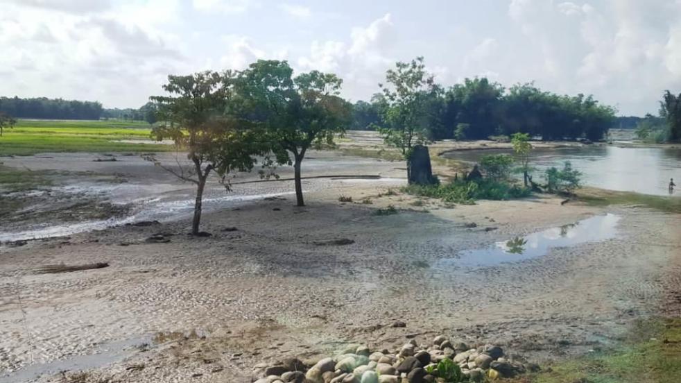
The flood of Jiadhal on 16 September breached the Jiadhal Station Road connecting Dhemaji Engineering College in Tinighariya village. Apart from this the swollen river this time destroyed vast acres of agriculture land with newly growing paddy in half a dozen villages—all habited by indigenous Mising community, Schedule Tribe group in Assam. Green paddy fields in villages Azarbari, Kekuri Miri, Narabeel, Panitola, Hesuli Pathar, Tegjuri Koch Pathar Part-I from the slopes of the sub-Himalayan hills of Arunachal Pradesh to the National Highway-15 turned white overnight with sand and silt deposited by the overflowing river. Besides leaving the peasants with the loss of this year’s harvest, the Jiadhal floods has also deprived the family of Bipin Pegu of their burial site.

A river synonymous with flood and bank erosion
Dhemaji district of Assam till very recently was known as the sorrow of the state as it was devastated by the flood of its rivers every year to a large extent. All the major rivers in the district, originating in the hills of Arunachal Pradesh to its north swell dangerously during monsoon every year as heavy rain lash the region. The flood very badly disrupted road transport in Dhemaji besides causing tremendous losses to the agriculture—the only economic activity of the district. Among all such rivers Jiadhal was the symbol of a unique phenomenon of flood related destruction. Jiadhal, a northern tributary of the Brahmaputra originates in the sub-Himalayan mountains of Arunachal Pradesh at an altitude of 1247m above the M.S.L. (Mean Sea Level) After passing through a narrow gorge in Arunachal Pradesh, the river enters the plains of Assam in Dhemaji district where it flows in braided channels. The river is known as ‘Kumotiya’ from the railway line to Gogamukh-Ghilamara P.W.D. road in Lakhimpur district, wherefrom it is called ‘Sampara’. The river finally debouches into the Brahmaputra near Selamukh in Lakhimpur district. But after construction of the embankment over the Kherkutiya Suti of the Brahmaputra, the river confluences with the Subansiri River.

The sub-basin of Jiadhal experiences heavy rainfall. The average annual rainfall as recorded at Dhemaji is 3,500 mm. It carries heavy silt load from its 1346 sq. km catchment area during the rainy season and deposits them on its bed in the plains resulting in the considerable rise of its riverbed. Jiadhal is known for frequent changing of its course and this caused devastating flood in 1984, 1988, 1989, 1992, 1994, 1997, 1998, 2002, 2007, 2009, and 2011 bringing disasters to this area creating a widening of its courses to a cobweb like phenomenon in Samarajan. It has been estimated that till 2011 Jiadhal floods severely affected about 85 villages and 300 hectares of crop land, including a large area with standing crops.

Till early 2019, a stretch of about 3 kilometres on NH (National Highway)-15 between Bordoloni and Dhemaji was a driver’s nightmare due to the curious course of Jiadhal. The entire area along with the railway track and bridge with vast paddy fields had been the centre of a unique concentration of unpredictable course of Jiadhal (called Kumotyia in that area) river making it un-motorable. For almost two decades people were compelled to cross this stretch during monsoon sometimes on boats, over makeshift bamboo bridges or through waist deep water. It is only in early 2019 that this stretch on NH-15 in Samarajan was turned hospitable with construction of as many as eight big and small RCC bridges. The Northeast Frontier Railway too constructed two steel bridges in close proximity in Samarajan in its upgraded Rangia-Murkongchelek tracks.

The Jiadhal River is a classic example of a flashy river and produces floods with a sudden, high discharge over a short time interval (a few hours to a day) and with a high sediment load and debris. The flashiness of the river can be mainly attributed to high rainfall in the upstream hilly catchment and the basin as a whole, and the steep zone between the foothills and the flat alluvial plains through which the river flows. Flash floods in this river are generally triggered by continuous heavy rainfall or extreme rainfall events such as cloudbursts. When Bipin Pegu was talking about the inundation of their family burial site near the railway bridge of Jyadhal under a bright sun, we heard sounds of thunder in the blue hills of Arunachal Pradesh just 10 kms away. Bipin and some other fellow villagers pointed towards the gorge in the hills that looked foggy—the emerging point of Jiadhal in West Siang district of Arunachal Pradesh. The foggy foreground among the blue hills in that bright sunny day meant rains which would bring more water to Jiadhal passing through the villages up to NH-15 in Dhemaji. Though these villagers has been experiencing the flood with sediment load and debris in Jiadhal in last four decades, a delay has been witnessed in the surge of water in last couple of years. This time too, Jiadhal swelled in mid-September—almost two months later the usual.

Increasing incidents of cloudbursts in the Himalayas have also been attributed to climate change. While global temperature is recorded to have increased by about 0.8°C in recent decades, the increase has been greater in regions at higher altitudes like the Himalayas where the decadal temperature rise is higher than the global rate of rising temperatures. According to a study published in the journal Elsevier in January 2018, the reported rate of warming over the eastern Himalaya was over 0.6 °C/100 year during 1901–2002. “The Tibetan plateau and Brahmaputra basin showed the largest increase during spring season with 0.2 °C/decade during 1971–2005 over northeast India and warming of 1.6°C across the north-western Himalayan region during 1901–2002,” the study says. According to Sandipan Mukherjee, scientist at GB Pant National Institute of Himalayan Environment and Sustainable Development, the warming has wreaked havoc on the monsoonal patterns in the Himalayas resulting in increased moisture levels.

The thunder heard from Tinighariaya village off the Jiadhal river is likely to be sound of cloudbursts—an extreme amount of precipitation, sometimes accompanied by hail that normally lasts no longer than a few minutes, but discharges a large amount of water in a small area. For the villagers Azarbari, Kekuri Miri, Narabeel, Panitola, Hesuli Pathar, Tegjuri Koch Pathar Part-I on the either side of Jiadhal in Dhemaji district of Assam, the 16 September 2019 event created another havoc lasting for few hours but robbing their dreams of a golden harvest this year. The deposition of coarse sand and silt particles on the inundated plains by the flash flood makes the land unfit for agriculture. About 5.72 square km of land in more than a hundred villages has been seriously affected by sandcasting by Jiadhal floods (Deka, 2008)[i]. Study indicates that in the last four decades (1973–2010), the area affected by sand has increased by 18% resulting in the 34% decrease of both summer and winter crops. Like in the last four decades, this time too this has emerged as the most serious impact of floods in the Jiadhal River catchment. The Jiadhal floods have taken the lives of 48 people between 1989 and 2002[ii]. So far, the Jiadhal floods have been treated as a mere bank protection issue as its surging water breached its embankments at different places in the last four decades. The climate perspective should also be looked into.
Sazzad Hussain (sazzad.hussain2@gmail.com) is a freelance writer & independent researcher based in North Lakhimpur, Assam
Note: An edited version of this has been published here: https://nenow.in/opinion/climate-change-impacts-on-indigenous-communities-the-curious-case-of-assams-jiadhal-river.html.
END NOTES:
[i] Deka, CR “Land Degradation by Jiadhal River of Dhemaji District: A Study Using Remote Sensing and GIS Technique”, Assam: ENVIS, October-December-2008
[ii] Hazarika, LP http://www.neptjournal.com/upload-images/NL-1-37-(37)B-1350.pdf
