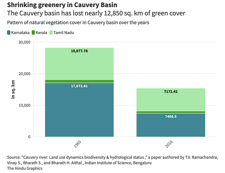
CWC - Central Water Commission

2022: Overview of CWC’s Flood Monitoring Sites in North East India

During monsoon CWC (Central Water Commission) monitors water level at several hundred sites in the county and publishes this information on its Flood Forecast website[I]. The website has three ways to get this information: Data Flow Map, List Based Exploration, and Hydrograph view. The Hydrograph view provides information for past 72 hours, supposed to be updated every hour. This is in addition to the list of current forecasts listed on the website.

Since 2018, SANDRP has been analyzing CWC’s flood forecast website in zone wise manner. After examining status of flood forecast and monitoring sites in North Indian[II] states, this overview is for North East India region covering Arunachal Pradesh, Assam, Meghalaya, Manipur, Nagaland, Tripura, Mizoram and Sikkim states. This also includes part of North West Bengal that is in Brahmaputra basin. Our 2018 and 2019 analysis on the North East region can be seen here[III] and here[IV].  .

Continue reading 2022: Overview of CWC’s Flood Monitoring Sites in North East India
Dam floods · Dams

Dams Floods 2018: Filling up Dams well before Monsoon end, Invitation to Disaster

The tendency of filling up reservoirs in the beginning and middle of monsoon season have been leading to avoidable flood disasters in the country. Apart from Kerala flood 2018, which was aggravated by mismanagement of reservoirs, various reports show that reservoirs in river basin of Cauvery, Krishna, Godavari and Ganga were also filled up well before the end of South West monsoon season. Resultantly there were many man made flood spells in downstream areas affecting lives and livelihoods of people.

After highlighting role of dams in floods in Kerala and how improper dam operation affected people in Assam and Himachal Pradesh, this third and concluding part throws light on other dam induced flood (and canal breach) incidents in 2018. Continue reading “Dams Floods 2018: Filling up Dams well before Monsoon end, Invitation to Disaster”

Dams · Floods

Overview of CWC Flood Forecasting Sites 2018: East India 

Central Water Commission is the only agency doing flood forecasting in India. As per CWC’s Flood Forecasting website[I] the Data Flow Map has information about 226 Flood Forecast Sites in the country comprising of 166 Level Forecast Sites and 60 Inflow Forecast Sites. It also monitors 700 Flood sites, information made available through List Based Exploration and Hydrograph View, but no flood forecasting is done for these sites.

In order to better understand the CWC’s flood monitoring and forecasting work, in this article we have given an overview of CWC’s flood forecasting and monitoring sites in East India. It includes state wise list of CWC’s Level Forecast, Inflow Forecast and level monitoring sites in East India. Similar report has been published for North India[II] and North East India[III] and we hope to publish reports covering other regions of India too. 

Continue reading “Overview of CWC Flood Forecasting Sites 2018: East India “