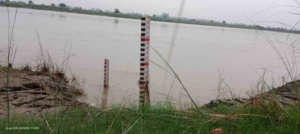
(Feature Image: Yamuna river near ISBT, Delhi on Aug. 23, 2026. BS Rawat/SANDRP)
In the third month of the 2026 southwest monsoon season, we have been able to document rivers breaching their respective Highest Flood Levels (HFLs) at least at 10 Central Water Commission (CWC) flood monitoring sites. These sites are spread across five river basins and four states mainly in central and east India.
Half these sites are in the Ganga basin followed by two in the Brahmani & Baitarani basin and one each in the Mahanadi, Godavari and East Flowing Rivers between Mahanadi & Pennar basins. State-wise, Madhya Pradesh and Odisha account for eight of the 10 sites, with four each, followed by one site each in Uttar Pradesh and Chhattisgarh.
The sixth column of each table provides information on the increase in meter (m) over the previous HFL, the duration in hours (hrs) for which the river remained in extreme floods and the number of years (yrs) since the previous HFL was recorded. The details of 15 CWC flood monitoring sites where rivers attained new HFLs in July 2026, can be seen here.
1 Ganga Basin
| SN | Site/ River | District/ State | Old HFL/ Date | New HFL/ Time/ Date | Rise/ Duration/ Year/ |
| 1 | Rewa/ Tons | Rewa/ Madhya Pradesh | 265.45 m/ 0208.2021 | 266.16 m/ 18:00 hr/ 20.08.2026 | +0.71 m/ ~24 hrs/ 05 yrs |
| 265.45 m/ 0208.2021 | 266.08 m/ 20 hr/ 30.08.2026 | +0.63 m/ ~29 hrs/ 05 hrs | |||
| 2 | Sohar/ Mohan | Singrauli/ Madhya Pradesh | 256.39 m/ 30.09.2019 | 256.93 m/ 15 hr/ 31.08.2026 | +0.54 m/ ~37 hrs/ 07 yrs |
| 3 | Chitrakoot/ Paisuni | Satna/ Madhya Pradesh | 142.65 m/ (2003) | 145.6 m/ 13:00 hr/ 29.08.2026 | +2.95 m/ ~06 hrs/ 23 yrs |
| 4 | LALGANJ/ Belan | Mirzapur/ Uttar Pradesh | 137.55 m/ 17.07.2025 | 139.15 m/ 20:00 hr/ 18.08.2026 | +1.6 m/ ~16 hrs/ 01 yr |
| 137.00 m/ 01.08.2021 | |||||
| 5 | Kairi/ Belan | Rewa/ Madhya Pradesh | 95.85 m/ 01.08.2021 | 96.37 m/ 07:00 hr/ 19.08.2026 | +0.52 m/ ~24 hrs/ 05 yrs |
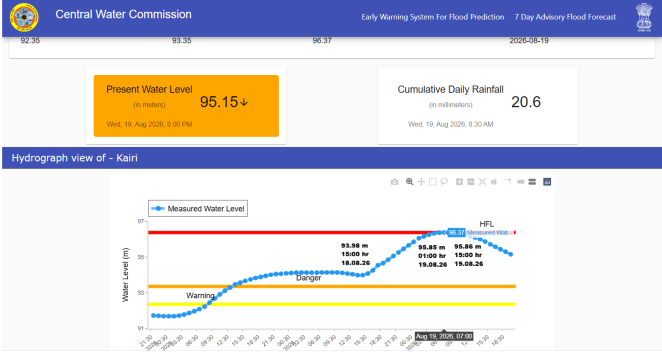
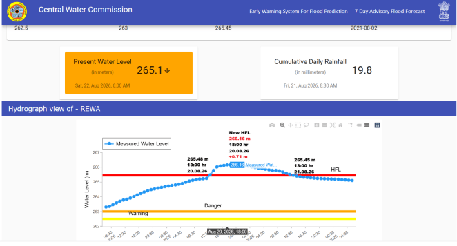
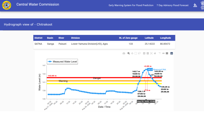
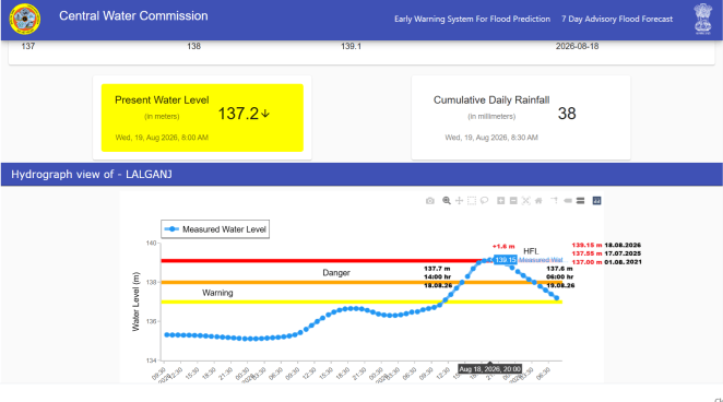
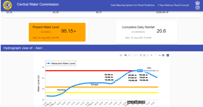
The five HFL breaches have occurred on four small rivers feeding the Ganga and Yamuna systems. Among them, the Paisuni (Mandakini) river at Chitrakoot has crossed the old HFL with highest margin of 2.95 meters & reportedly after 23 years.
2 Mahanadi Basin
| SN | Site/ River | District/ State | Old HFL/ Date | New HFL/ Date | Rise/ Duration/ Year/ |
| 1 | Bangodam/ Hasdeo | Korba/ Chhattisgarh | 302.1 m/ 23.09.1984 | 303.5 m/ 01:00 hr/ 17.08.2026 | 1.4 m/ ~12hrs/ 42 yrs |
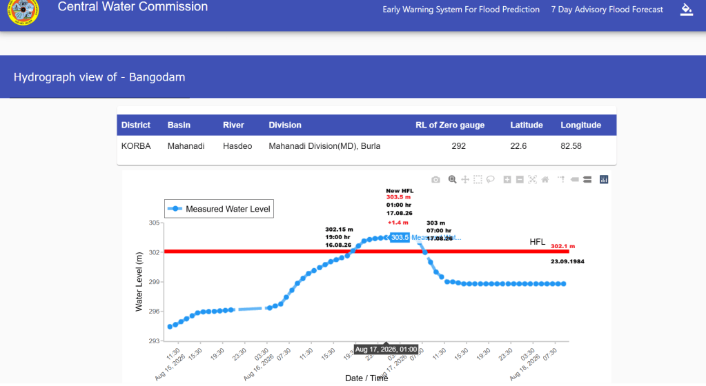
Notably, the Hasdeo River at Bangodam site has crossed the old HFL after 42 years.
3 Brahmani and Baitarani Basin
| SN | Site/ River | District/ State | Old HFL/ Date | New HFL/ Date | Rise/ Duration/ Year/ |
| 1 | Keshdihi/ Baitarani | Mayurbhanj/ Odisha | 317.79 m/ 26.08.2020 | 318.08 m/ 10:00 hr/ 13.08.2026 | +0.19 m/ ~02 hrs/ 06 yrs |
| 2 | Bhejdih/ Baitarani | Mayurbhanj/ Odisha | 293.41 m/ 14.09.2021 | 293.45 m/ 07:00 hr/ 13.08.2026 | +0.04 m/ ~1 hr/ 05 yrs |
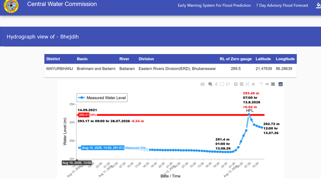
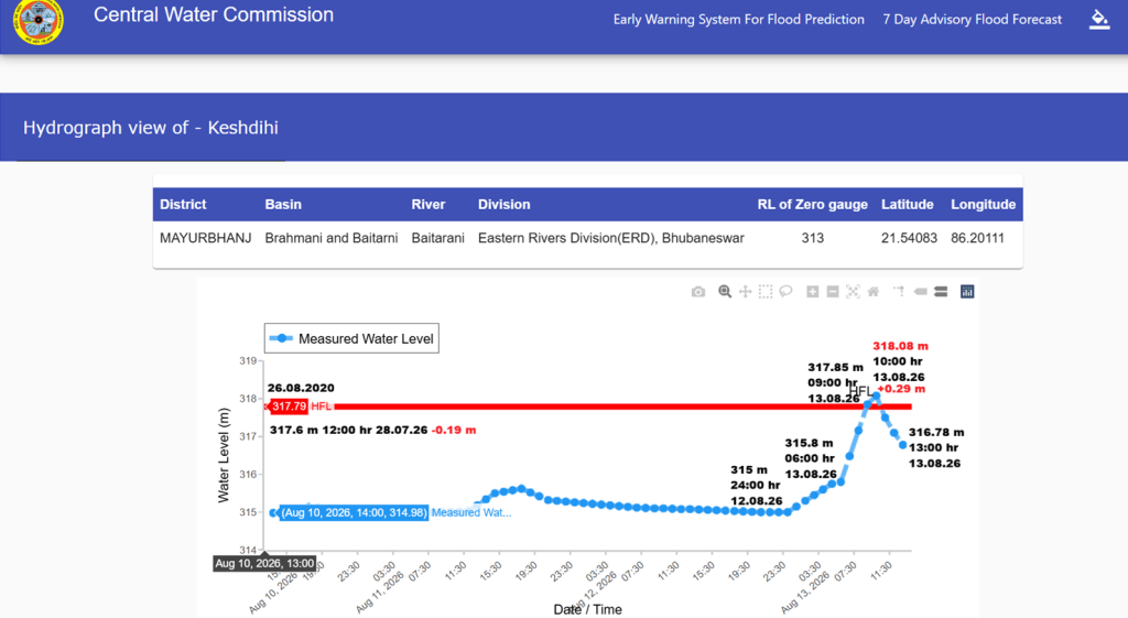
Interestingly, the Baitarani had missed crossing the HFLs by narrow margin at both (Keshdihi by 0.19 m & Bhejdih by 0.24 m) of the sites in July 2026.
4 East Flowing Rivers between Mahanadi and Pennar
| SN | Site/ River | District/ State | Old HFL/ Date | New HFL/ Date | Rise/ Duration/ Year/ |
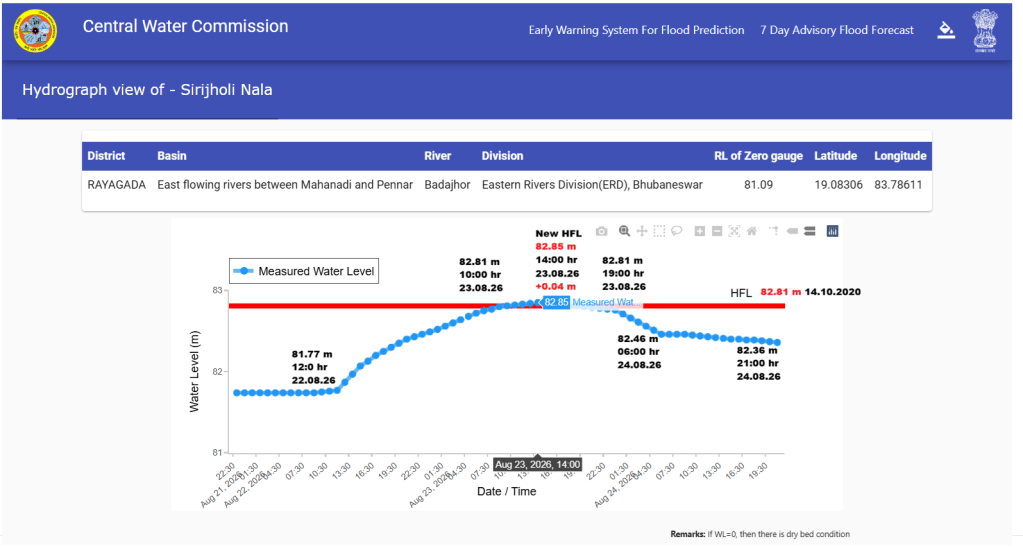
| 1 | Sirijholi Nala/ Badajor | Rayagada/ Odisha | 82.81 m/ 14.10.2020 | 82.85 m/ 14:00 hr/ 23.08.2026 | +0.04 m/ ~09 hrs/ 06 yrs |
5 Godavari Basin
| SN | Site/ River | District/ State | Old HFL/ Date | New HFL/ Date | Rise/ Duration/ Year/ |
| 1 | Ghatakusumi/ Journala | Nabranga- pur/ Odisha | 544.9 m/ 19.08.2025 | 547.37 m/ 16:00 hr/ 24.08.2026 | +2.47 m/ ~53 hrs/ 01 yrs |
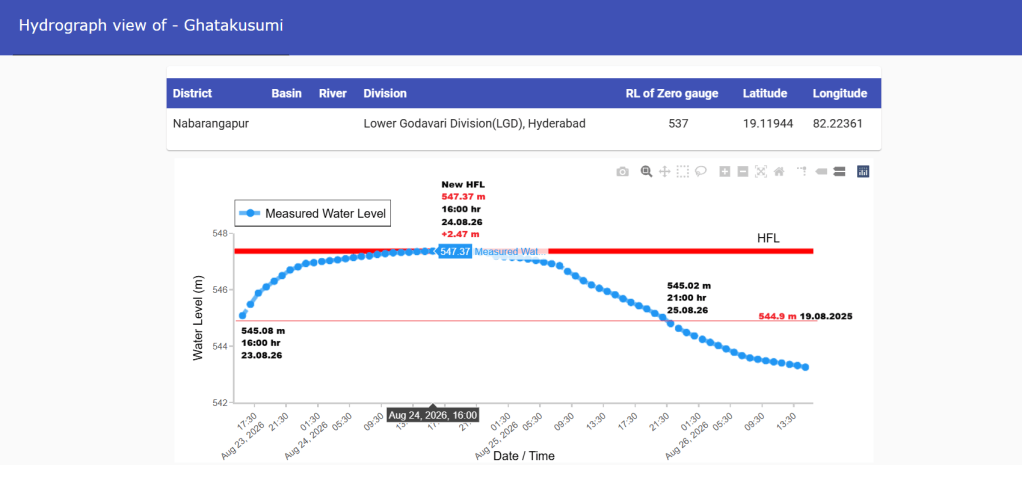
The hydrograph of the site lacks river and basin names but mentions it to be in lower Godavari division. The river remained in extreme flood condition for about 53 years at the site.
Rivers Flowing Close to HFLs: In addition to the HFL breaches, we could track 4 sites where flood levels reached close to the HFLs in the respective rivers in Aug. 2026.
| SN | Site/ River | District/ State | HFL/ Date | Peak Level/ Date | Gap |
| 1 | Madwas/ Gopad | Sidhi/ Madhya Pradesh | 325.45 m/ 17.09.2024 | 325.15 m/ 15:00 hr/ 14.08.2026 | -0.30 m |
| 2 | Rajhara/ North Koel | Palamau/ Jharkhand | 183.21 m/ 20.08.2019 | 183.2 m/ 15:00 hr/ 19.08.2026 | -0.01 m |
| 3 | Chakghat/ Tons | Prayagraj/ Uttar Pradesh | 96 m/ 18.07.2025 | 96.78 m/ 11:00 hr/ 02.08.2021 | -0.22 m |
| 94.7 m/ 02.08.2021 | |||||
| 4 | Mathani RB/ Jalka | Baleshwar/ Odisha | 7.31 m/ 22.09.2021 | 7.22 m/ 11:00 hr/ 13.08.2026 | -0.09 m |
The flood level in the North Koel River at Rajhara fell just 0.01 m short of its 2019 HFL on 19.08.2026. The river had also missed breaching the HFL at the same site by 0.26 m in Aug 2025.
Observations: In Aug. 2026, we have found two examples which again highlights CWC’s failure in updating HFL data and consistency in maintaining historical HFL records. In first case, the CWC did not update the 77.71 m HFL dated 24.08.2025 for Jirgo river at Ahraura site set up after crossing old HFL 76.8 m on 21.08.2020 at the site. As a result, the peak of 76.98 m attained on 26.08.2026 was wrongly shown as new HFL for the site.
In second similar case, the Paisuni (Mandakini) river at Sardhua site had reached 93 m HFL on 03.08.2025. However, the CWC continued to maintain the old HFL 91.42 m dated 28.08.2022 for the site. Therefore, when the river reached the peak of 91.50 m on 30.08.2026, it was shown as a breach of the 2022 HFL. Notably, the river had also attained 90.07 m peak at the site on 21.09.2019. After SANDRP brought the discrepancy to the CWC’s notice, the HFL records were corrected for both the Ahraura and Sardhua sites.
Likewise, Karwi, one of the CWC’s three flood monitoring sites on the Paisuni river, was found inactive when the river experienced a record flood in Aug. 2026. It is learnt the site was established in 2019 and was shifted to Chitrakoot in 2024.
While, the CWC hydrograph mentions 139.93 m as the HFL dated 03.10.2019 at Karwi site, the date for 142.65 m HFL at Chitrakoot site is unavailable. The old HFL year 2003 for the site is based on CWC’s interactions with local residents rather than on historical gauge record. This raises concerns about the reliability of historical flood level records maintained by CWC.
SANDRP


