This is the summary report of Highest Flood Levels (HFL) breach incidents which we could document from CWC’s flood monitoring website during South West Monsoon Season 2025. The monthly reports for HFL breach incident for July 2025, August 2025 and September 2025 can be seen by clicking the hyperlinks and the detailed final report can be seen here. SANDRP’s previous reports on the subject can be seen here: HFL breach incidents in 2018, 2019, 2020, 2021 (I), 2021 (II), 2022 (I), 2022 (II), 2023, and 2024.
Continue reading “Rivers in Extreme Floods During SW Monsoon 2025”Tag: flood management
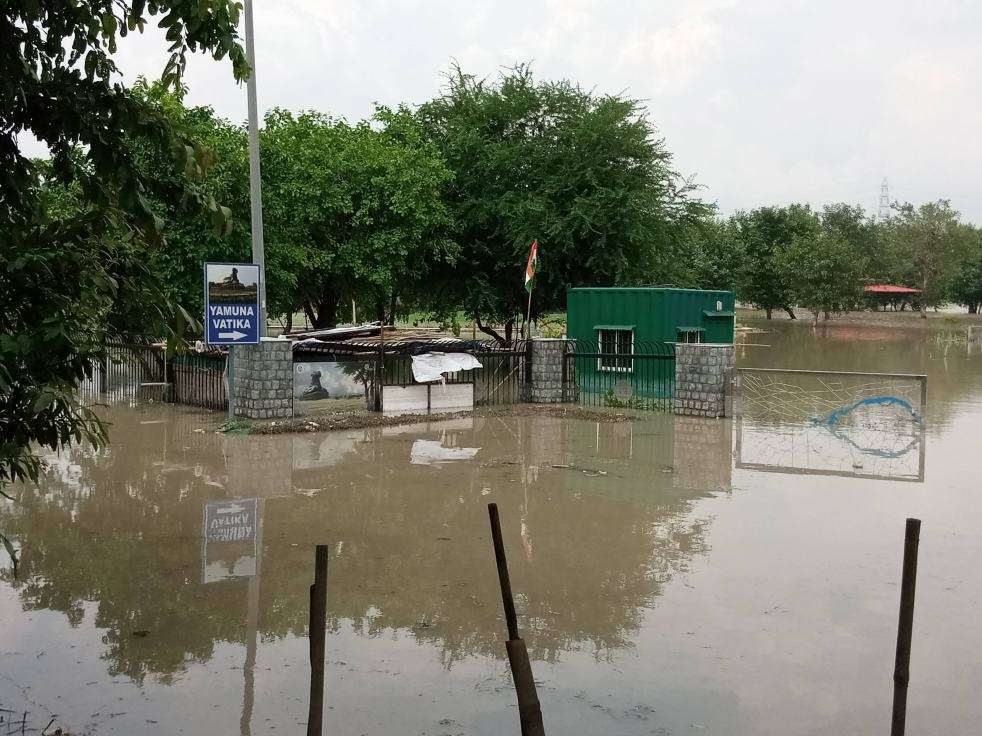
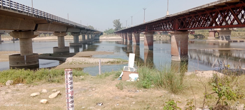
Yamuna Photo Blog Sept 2025: ‘Riverfront’ Projects submerged Again
(Feature Image: Entrace of Asita West projects flooded with Yamuna water on Sept. 05. 2025. Credit: Surendar Solanki)
Through pictures and satellite imagery, this blog documents the impact of Sept. 2025 Yamuna flood on Delhi Development Authority’s (DDA) riverfront projects. These 10 projects are being developed over the past 8 years in river floodplain and had also suffered damages during July 2023 floods. Earlier they were called part of floodplain rejuvenation but now being termed as Yamuna riverfront projects. DDA website has only shown name, size and location of riverfront projects, however has maintained secrecy on important factors of cost, progress, delays, damage and losses concerning these projects.
Continue reading “Yamuna Photo Blog Sept 2025: ‘Riverfront’ Projects submerged Again”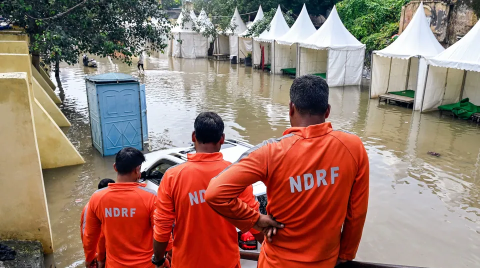
Sept 2025: Why did Yamuna Repeat July 2023 Like Flood Spell in Delhi?
(Feature Image: NDRF team gazing at flooded relief camps at Yamuna bazar, Delhi)
In first week of September 2025, Yamuna river in Delhi has again witnessed another unusual flood spell. This is happening two years after the river recorded unprecedent flood event in July 2023. This report compares the July 2023 flood with the one in Sept 2025 underlining the probable factors making these deluges uncommon and man-made flood disaster.
Continue reading “Sept 2025: Why did Yamuna Repeat July 2023 Like Flood Spell in Delhi?”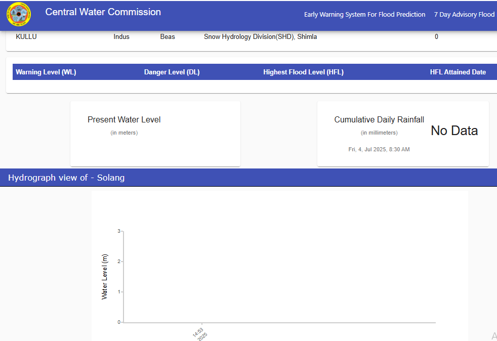
Himachal Pradesh: Why CWC’s Forecasting is Unavailable Amidst Flood Disaster?
(Feature Image: Screenshot of inactive hydrograph for Solang station on Beas river in Mandi district. Source: CWC Flood Forecast website)
Despite disastrous flood events causing significant destruction to human lives and infrastructures for past three years, the state of Himachal Pradesh has not seen much required improvements in flood monitoring and forecast servicesby the Central Water Commission’s (CWC) to help minimize the destruction toll.
Continue reading “Himachal Pradesh: Why CWC’s Forecasting is Unavailable Amidst Flood Disaster?”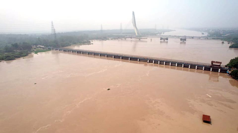
MoJS Comm. Report on July 2023 Delhi Floods: Fails to explain unprecedented flood levels
(Feature Image: A view of overflowing Yamuna river at Wazirabad in New Delhi on 13 July 2023. Credit: HT_PRINT/Source: Live Mint)
Post July 2023 unusual flood spell in Yamuna river reaching unprecedented levels in Delhi, the Ministry of Jal Shakti (MoJS) on August 06, 2023, constituted a committee for conducting a “Joint flood management study of river Yamuna for its reach between Hathnikund and Okhla Barrage”. The Committee headed by Chairman, Central Water Commission (CWC) & Ex-Officio Secretary to Govt of India with members from Haryana, Uttar Pradesh, NCT of Delhi and expert Organizations was mandated to examine the meteorological aspects, return period of floods, discharging capacity of barrages, functional requirement of ITO barrage, etc.
Continue reading “MoJS Comm. Report on July 2023 Delhi Floods: Fails to explain unprecedented flood levels”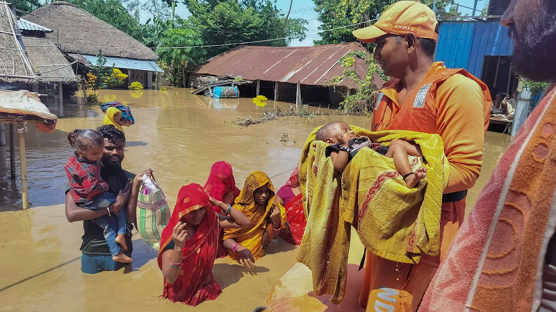
2024: Do Embankments save from floods or worsen the disasters?
(Feature Image: NDRF personnel conduct a rescue operation at a flood-affected area in Bihar’s Supaul district. Image Credit: PTI/Source Live Mint, Sept. 30)
India has seen several floods brought by breach of embankments during the 2024 monsoon. In Bihar, though the state has received deficit rainfalls, the overspilling of barrages and breaching of several embankments created widescale flood damages. Number of reports have again highlighted the ineffective and adverse role being played by flood protection structures in worsening the deluge impacts. The first part of the overview has covered dam induced flood incidents in the country during 2024 and third part has highlighted incidents of dam induced urban floods.
Continue reading “2024: Do Embankments save from floods or worsen the disasters?”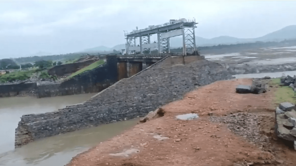
2024: Dam Induced Floods in India
(Feature Image: Breach in the earth dam of Peddavagu project flooded several villages in Telangana & Andhra Pradesh on July 17, 2024. Source: DC)
India has seen several manmade flood disasters during the 2024 monsoon. The mismanagement of dams in Narmada valley including Bargi, and SSP inundated several dam affected villages despite adequate actionable advance warnings. The uninformed excess releases from DVC dams have led to flooding in large areas in West Bengal as repeatedly raised by the state government. The extensive floods in Tripura have revealed glaring loopholes in flood prevention and disaster management.
The floods in the year have also washed away or damaged several earthen dams, tanks in Madhya Pradesh and Rajasthan affecting human population, agricultural lands in their vicinity. Even during Northeast monsoon, the sudden releases from Sathanur and Veedur dams in Tamil Nadu created avoidable flood damage in downstream areas. Similarly, the states of Gujarat, Telangana, Haryana and Delhi have seen deluge due to mismanagement or breaches in the canals. The case of Narmada canal waters flooding large areas of Little Runn of Kutch is quite concerning.
Continue reading “2024: Dam Induced Floods in India”
Dams, Rivers & People 2020 through the DRP LEAD STORIES
In SANDRP’s weekly News Bulletins, we select lead story each week. Here we try to look back and take stock of major happenings of 2020 through a compilation of DRP lead stories to recapitulate major happenings related Dams, Rivers, Water and Environment. While doing this we are aware that this may not completely capture all the key happenings in this sector, since not all the major developments are captured by the media and their headlines. However, it does provide some idea about what were the major developments in this sector in the just outgoing year 2020. We have divided the lead stories under several key classifications like River Management, Environment Governance, Dams, Hydropower projects, Flood management, groundwater management etc.
Continue reading “Dams, Rivers & People 2020 through the DRP LEAD STORIES”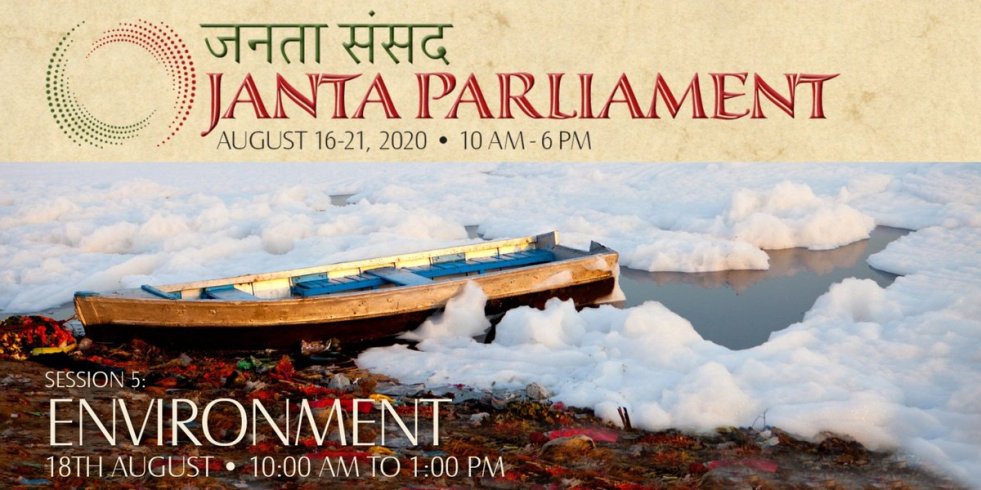
Janta Parliament discussion on the state of water in India
While Indian Parliament has not met since March 2020 (it is now slated to meet from Sept 14, 2020, though without a number of key features including absence of question hour), Civil Society Groups came together and held a Janta (people’s) Parliament from Aug 16 to 21 Aug 2020, where citizens from across the country from all walks of life enthusiastically participated. On Aug 18 there was a three-hour session on Environment issues[i] (such a session is a rarity in Indian Parliament), as part of which, there was a presentation on Water related issues where SANDRP coordinator was invited to speak. Two water related resolutions were passed among others, by the Janta Parliament, one on Flood Management and another on Urban Water Management. See below for details.
Continue reading “Janta Parliament discussion on the state of water in India”
CWC Flood Forecasting: Anomalies between Website and SOP Document
Central Water Commission (CWC) is the only agency in India doing flood forecasting, it becomes very important to understand what CWC does in this regard. The CWC flood forecasting website[i] is the main media through which CWC provides the flood forecasting. CWC has also published on its website, the document giving Standard Operating Procedure (SOP) for flood forecasting in 2018[ii]. The Home page of the CWC’s flood forecasting site says that CWC provides Level forecasting for 166 sites and Inflow forecasting for 60 sites. SOP document, however, gives these figures in Table 1, but in Table 2 (as also the full list given in Annexure 1.1 of SOP document), it gives state wise break up for 182 Level forecasting and 93 Inflow forecasting sites. So we can see anomalies in these two sources even about the number of forecasting sites.
Continue reading “CWC Flood Forecasting: Anomalies between Website and SOP Document”
