Sand Mining

Odisha River Sand Overview 2020: Another mining ravaged state

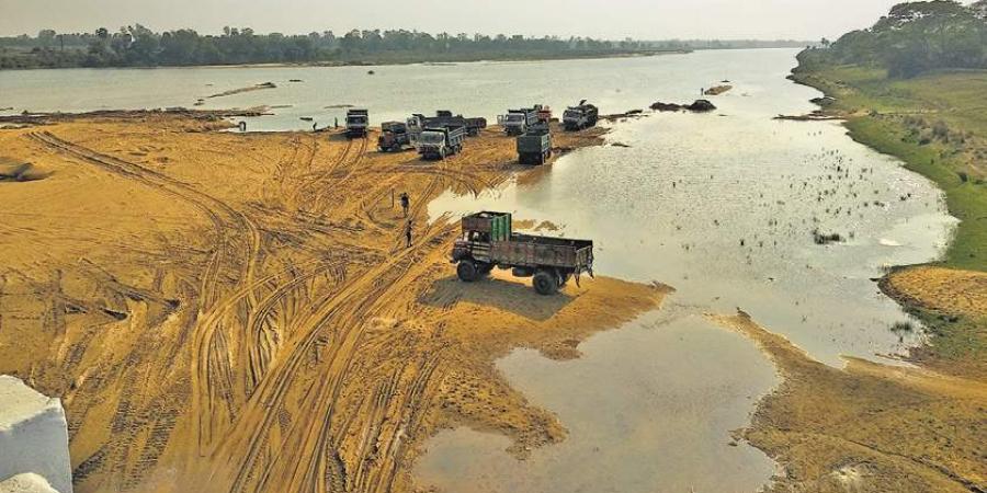
The overview presents picture of river sand mining in Odisha based on available information in public domain from past 18 months.

Illegal Sand Mining Incidents

May 2019 Brick kilns spur illegal mining Scores of illegal brick kilns operating in Samana and Habaleswar panchayats under Hatadihi block in Keonjhar district had spurred illegal mining from riverbeds. As a result, the state government was losing crores of rupees revenue. The miners had encroached upon government and pastureland and set up brick kilns without sanction of the Odisha State Pollution Control Board.

Continue reading “Odisha River Sand Overview 2020: Another mining ravaged state”
central water commission

East India: 2019 Overview of CWC Flood Forecasting Sites 

Central Water Commission (CWC) is the only agency doing flood forecasting in India. CWC’s Flood Forecasting (FF) is available on its website[I]. In this article we have given an overview of CWC’s flood forecasting and monitoring sites in East India. It includes state wise list of CWC’s Level Forecast, Inflow Forecast and level monitoring sites in East India. Similar report has been published for North East India[II] and North India[III] and we hope to publish reports covering other regions of India soon. East India includes five states: Bihar, Jharkhand, Chhatisgarh, Odisha and W Bengal.

Continue reading “East India: 2019 Overview of CWC Flood Forecasting Sites “

Dams · Floods

Overview of CWC Flood Forecasting Sites 2018: East India 

Central Water Commission is the only agency doing flood forecasting in India. As per CWC’s Flood Forecasting website[I] the Data Flow Map has information about 226 Flood Forecast Sites in the country comprising of 166 Level Forecast Sites and 60 Inflow Forecast Sites. It also monitors 700 Flood sites, information made available through List Based Exploration and Hydrograph View, but no flood forecasting is done for these sites.

In order to better understand the CWC’s flood monitoring and forecasting work, in this article we have given an overview of CWC’s flood forecasting and monitoring sites in East India. It includes state wise list of CWC’s Level Forecast, Inflow Forecast and level monitoring sites in East India. Similar report has been published for North India[II] and North East India[III] and we hope to publish reports covering other regions of India too. 

Continue reading “Overview of CWC Flood Forecasting Sites 2018: East India “

Dams

Odisha Rivers Profile

About Odisha

Odisha is located on the eastern coast of India, between 17o31‟ and 22o 31‟ N latitude and 81o 31‟ and 87 o 31‟ E longitude. It covers 155,707 km2 , which represents about 4.74% of the area of India. The climate of state is tropical with 1450mm average rainfall.

The 2011 Census established the State‟s population at 41.9 million, 16% of which lived in urban centres. The average population density is 270 persons per km2, compared to 382 for India.  Odisha is a land of possibilities. The State is endowed with bountiful of resources, people, land, water, forest, minerals and other minor resources. The State is divided into 30 districts, of which Mayurbhanj is the largest (1042km2) and Jagatsinghpur the smallest (197km2). The districts are subdivided into 314 CD Blocks. There are 58 sub-divisions and 171 tahasils. According to 2001 census there are 51,349 villages and 6234 Gram Panchayats.(ORISSA STATE WATER PLAN, 2004). 

Continue reading “Odisha Rivers Profile”