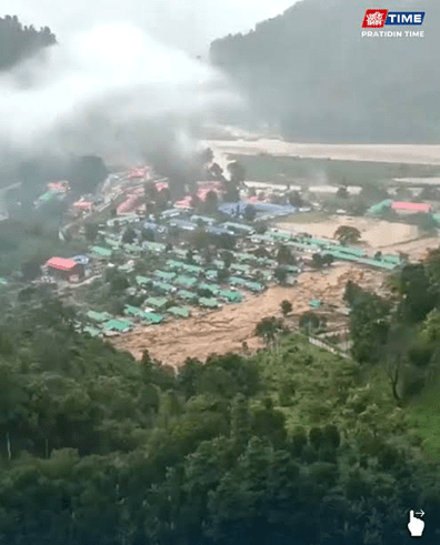
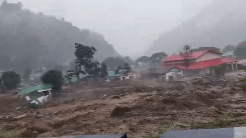
(Feature Image: Scren grab of flash flood passing through NEEPCO 43 Colony at PLHEP site in mornng hour of June 24, 2026. Source: Pratidin Time news)
A severe flash flood spell in the Poosa–Yazali area of Keyi Panyor district, Arunachal Pradesh on June 24, 2026, has significantly affected NEEPCO’s 43 colony located near the Panyor Lower Hydroelectric Project (PLHEP) site, close to the reservoir of the HEP. The disaster occurred around 6 in the morning, heavy spell creating a cloud burst like situation.
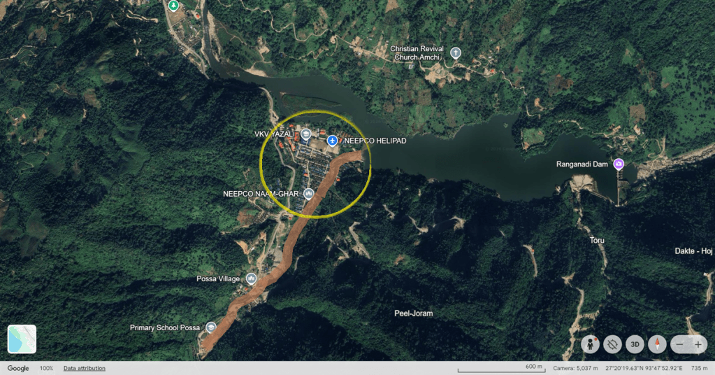
The flood appears to have originated in a small unnamed stream joining the Panyor river from the southern side, about 2 km upstream of the PLHEP dam. The NEEPCO 43 Colony is situated near the confluence of this stream and the Panyor within the reservoir backwater zone.
The PLHEP earlier known as the Ranganadi HEP, is a 405 MW project developed by NEEPCO. Commissioned in 2002, the project is located on the Panyor (Ranganadi) river, a tributary of the Subansiri river in Brahmaputra basin. The project has faced criticism in the past over downstream flood impacts in Assam by sudden water releases.
Observations indicated that Yazali received about 72.8 mm rainfall in 24 hours, with the heaviest spell occurring between 6 am and 9 am on 24 June, triggering flash floods, debris flows and landslides. Rescue, restoration and damage assessment operations were continuing as access to many affected locations remained blocked.
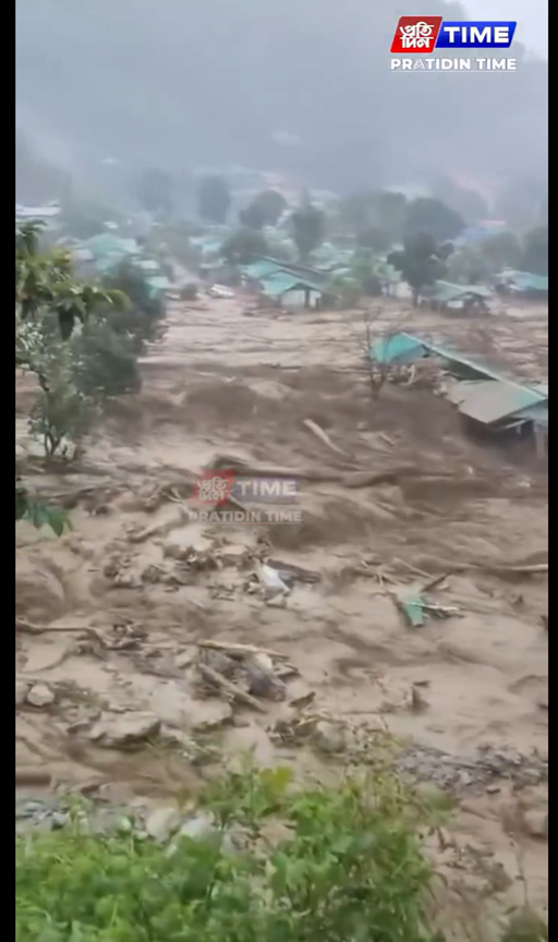
Based on the Arunachal Pradesh State Emergency Operation Centre (SEOC) Daily Situation Report dated 24 June 2026 shared on Disaster Management department face book page in late evening, the flash flood caused extensive damage in and around the NEEPCO Colony near the PLHEP. The flood was triggered after an under-construction retaining wall collapsed, allowing large volumes of water to inundate low-lying residential areas of the NEEPCO colony.
Preliminary reports recorded five missing persons, 17 injured people, including three critically injured persons shifted to Gyati Taka District Hospital, Ziro and one confirmed female fatality. Authorities also evacuated five persons from the affected area. Search and rescue operations were carried out by SDRF, district police and other emergency personnel, while NDRF teams were kept on standby.
As per latest report, one person, Nirmala Gupta (35) was confirmed dead, while four others namely Elesh Marak (13), Balari Marak (30), Tao Anjina (46) and Sourav Kumar – remained missing. District police and SDRF personnel rescued a boy, Bishu Sinha along with his pet dog from the Yazali reservoir area. A scientist of the Geological Survey of India (GSI), stranded due to landslides along National Highway-13, was also rescued.
The report confirmed damage to 18 residential quarters in the NEEPCO colony. Several affected areas remained cut off because of landslides from both the Yazali side and the Hoj–Potin side. The NEEPCO helipad was damaged hampering helicopter-based rescue operations. As per local reports nearly 40 per cent of the NEEPCO colony has been affected.
The deluge has also significantly damaged public amenities in the area. Authorities reported that three stretches of NH 13 were blocked, several travellers were stranded and the Poosa–Ziro road was blocked at Pitapool and other locations. A small bridge on the highway was reported to be on the verge of collapse.
The SEOC report also noted wider infrastructure losses in the district, including damage to roads, power lines, electric poles, bridges, culverts, water supply systems, retaining walls and flood-protection structures. Preliminary state-wide damage statistics included impacts to 56 roads, 21 power lines, 60 electric poles, 11 bridges, 18 culverts, 140 water-supply installations, five retaining walls and four hydropower-related structures, though not all of these were necessarily confined to the NEEPCO colony.
Following the flood damage, the NEEPCO has temporarily shut down generation at the PLHEP. As the inflows increased sharply, the project authorities opened one spillway gate of the PLHEP dam by 1.5 metres, releasing around 230.83 cumecs of water. As per NEEPCO the shutdown was a precautionary measure after damage caused by the cloudburst and flash floods. The flood has also prompted downstream alerts in Assam, with districts including Dhemaji, Lakhimpur, Biswanath, Sonitpur and Dhubri asked to remain vigilant due to the possibility of rising river levels over the next 24–48 hours.
According to Dani Sulu, Secretary State Disaster Management Authority (SDMA) restoration work will begin once weather conditions improve.
Questions Raised by the incident:
The episode raises serious questions about disaster preparedness and risk management in one of India’s most climatically and geologically fragile regions. The available evidence suggests significant gaps in forecasting, monitoring, preparedness, communication and mitigation.
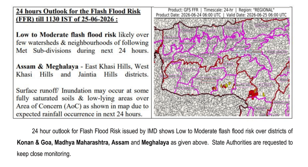
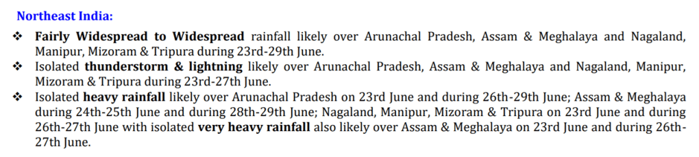
Firstly, neither the India Meteorological Department (IMD) nor the Central Water Commission (CWC) appears to have anticipated the severity of the event. IMD’s 24-hour Flash Flood Risks (FFR) Outlook issued at 06:00 IST on June 24 did not specifically indicate a high flash-flood risk for Keyi Panyor district.
A basic rainfall monitoring issue has also emerged. Keyi Panyor became Arunachal Pradesh’s 26th district in March 2024. However, IMD’s district-level rainfall reporting system still does not separately report rainfall data for the district. The IMD still reports data for only 16 districts of Arunachal Pradesh, when state has 28 districts now. This is shocking shortcoming of IMD’s basic rainfall monitoring. Does it mean there are no automatic rain-gauge stations in entire Keyi Panyor district?
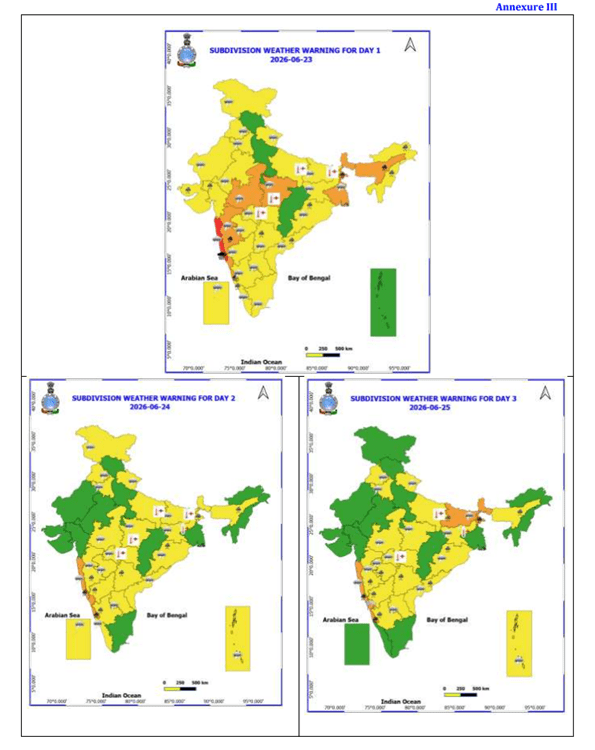
Similarly, the CWC’s Daily Flood Situation Reports of June 23 and June 24 did not provide any specific warning of an impending flash-flood event in the district, despite placing the broader region under flood and heavy rainfall alert categories.
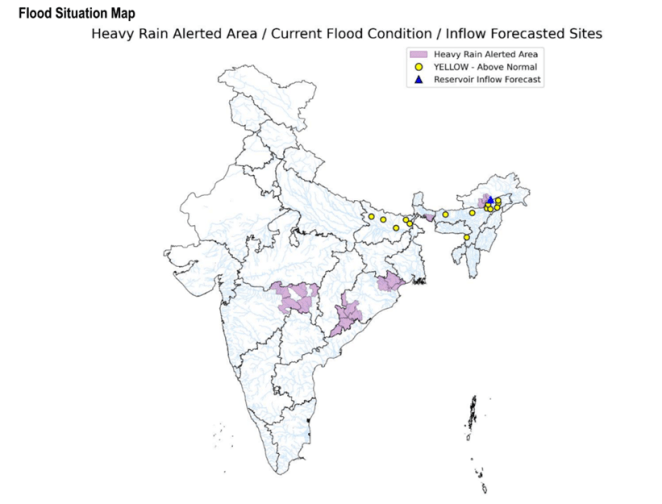
Despite the history of flood-related controversies associated with the Panyor basin, hydrological monitoring remains limited. The CWC maintains only one flood monitoring station Yazali on the approximately 150-km-long Panyor River.
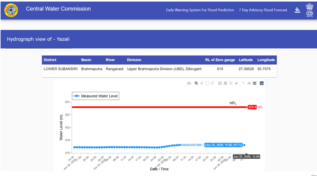
The Yazali gauge station is located about 40 km upstream of the PLHEP dam and did not record any unusual rise in flood level on account of the disaster. This suggests that existing monitoring networks may be inadequate for detecting highly localised extreme rainfall and flash-flood events in sensitive Himalayan catchments.
Thirdly, there is little publicly available information on the disaster preparedness measures adopted by NEEPCO for the PLHEP. The way the so called protection wall collapsed, the way the NEEPCO colony got washed away, the way houses and vehicles were washed away in minutes, raises serious questions about NEEPCO’s capacity to understand and deal with such issues, leave aside having any confidence on its capacity to manage a major risky infrastructure like hydropower project in such vulnerable terrain.
The company has not issued any public statement on the extent of damage to project infrastructure, investigation into the incident or future mitigation measures. It also remains unclear whether a basin-wide Early Warning System (EWS), real-time rainfall monitoring network, debris-flow monitoring system or community-based emergency warning mechanism exists in the Panyor catchment.
The episode has warranted scrutiny of state-level disaster communication systems. The official Face Book page of Keyi Panyor district had not been updated since May 29 and carried no information about the disaster during the critical initial period. The SDMA website similarly lacked timely updates.
Information emerged primarily through the Facebook page of the Department of Disaster Management, which first posted a general monsoon advisory for flood and landslide in evening hours of 24.06.2026 advising riverbank residents of Papumpare, Keyi Panyor and Lower Subansiri districts to remain alert and follow official weather forecasts. And later shared preliminary details on the impact of the disaster. In an era of increasingly frequent extreme weather events, timely dissemination of location-specific warnings and impact information is essential.
Preliminary examination of Google Earth imagery suggests that residential settlements and project-related infrastructure have been established within a naturally flood-prone area, possibly encroaching on or impact zone of the rivers. Construction activities, including retaining walls and other structures, may have reduced the stream’s natural floodplain and flow corridor, potentially increasing flood vulnerability during extreme rainfall events. NEEPCO was clearly caught unable to protect its own colony.
This incident leaves us with many questions and very few answers, as Assam Times asked: If a project equipped with advanced scientific instruments, monitoring systems and technical expertise is unable to protect its own colony from such an event, then an uncomfortable question emerges: how will downstream communities continue to place complete faith in the data, predictions and assurances provided by the same system?
What exactly happened in the catchment? Was it purely a cloudburst? Was there any role of local geological or hydrological conditions? How effective are our present early-warning systems for non-dam-induced flash floods? Are monitoring systems in place and functioning as intended? And perhaps most importantly, are we learning quickly enough from each disaster before the next one arrives?
The tragedy should become an opportunity to ask questions, improve transparency, strengthen scientific monitoring and build a more resilient warning system for both upstream and downstream communities. Because the river will always test our assumptions. The real question is whether we are prepared to learn from it.
Need for Independent Review
The incident highlights the growing exposure of hydropower projects and associated infrastructure in Himalayan region to extreme rainfall, flash floods and debris flows and other disasters under a changing climate. It also shows that the safety of the dams cannot be assessed solely in terms of its structural strength and operations. The associated infrastructure such as colonies, roads, retaining walls, bridges and emergency access routes can also become critical points of failure making the dam and downstream areas vulnerable to additional disasters.
There is urgent need of an independent investigation to examine the precise causes of this disaster and to review the effectiveness of NEEPCO’s, IMD’s, CWC’s monitoring and vulnerable district’s forecasting and warning systems. The preparedness of project authorities and the government agencies including SDMA also invite scrutiny. The findings of the report should be placed in the public domain.
The disaster further underlines the urgent need for basin-level early warning, flood forecasting, increase in hydrometeorological monitoring networks, transparent reservoir operation protocols & information about reservoir operations, functioning of EWS and regular disaster preparedness audits for hydropower projects in the Himalayan region.
SANDRP
