The Brahmaputra is believed to have two mythological fathers – Lord Brahma and sage Shantanu. In the 16th-century text Yogini Tantra, dedicated to the worship of goddesses like Kali and Kamakhya, the river is linked to an ancient ablution ritual with the following invocation:
O Son of Brahma! O Son of Shantanu! O Lohit! O Son of Lohit!
I bow before you, wash away my sins of the last three births.
Tag: Siang
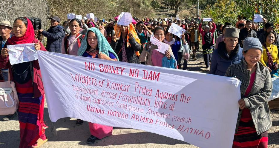
2024: People’s Resistance against Dam, Hydro Projects in Himalayan States
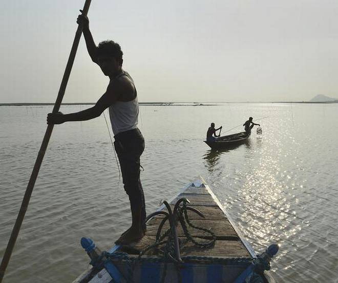
(Feature Image: Tribals in Siang river belt in Arunachal Pradesh demonstrating against a proposed mega hydropower dam. Photo Credit: Special Arrangement/The Hindu)
All through 2024, the vulnerable communities across Himalayan states have continued their resistance and struggles against proposed, under construction & damaged hydro and dam projects as can be seen in this yearend roundup.
The tribals in Siang valley have been urging Central and State govts to stop pushing the giant SUMP. In Teesta valley the GLOF, flood and landslide though have served as wake-up call, the planners seem to ignore the warnings. Facing adverse impacts, the native people in Manipur have resolved to stop further extension to Loktak lake HEP. In Nagaland, fearing damages, the villagers have made the future of Dikhu HEP uncertain.
Continue reading “2024: People’s Resistance against Dam, Hydro Projects in Himalayan States”
2023: People’s Protests Against Hydro & Dam Projects in India
(Feature Image: Joshimath locals take part in a protest rally against the NTPC project in landslide-hit Joshimath town of Chamoli district, Uttarakhand. PTI Photo/Source: Financial Express)
This yearend overview compiles the ten remarkable reports on community led protests against dam and hydro power projects in India in 2023. The report also covers some important judicial and government decisions regarding dams related issues during the year. It further compiles some relevant reports which significantly highlight bleak future of hydro and dam projects due to persistent decline in power generation, rise in construction cost and corruption issues. The first part of the overview detailing on dams and hydro projects related disasters in 2023 can be seen here.
Continue reading “2023: People’s Protests Against Hydro & Dam Projects in India”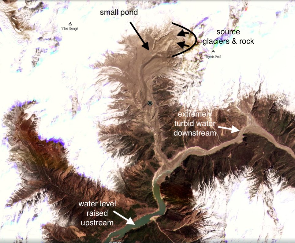
Massive Landslide on Yarlung Tsangpo on March 22, 2021
Dave Petley has on March 29, 2021[i] reported that a massive landslide has occurred along Yarlung Tsangpo river in Tibet, just upstream of Great Bend. (coordinates: 29.815, 94.932, the centre of the landslide source.)
Continue reading “Massive Landslide on Yarlung Tsangpo on March 22, 2021”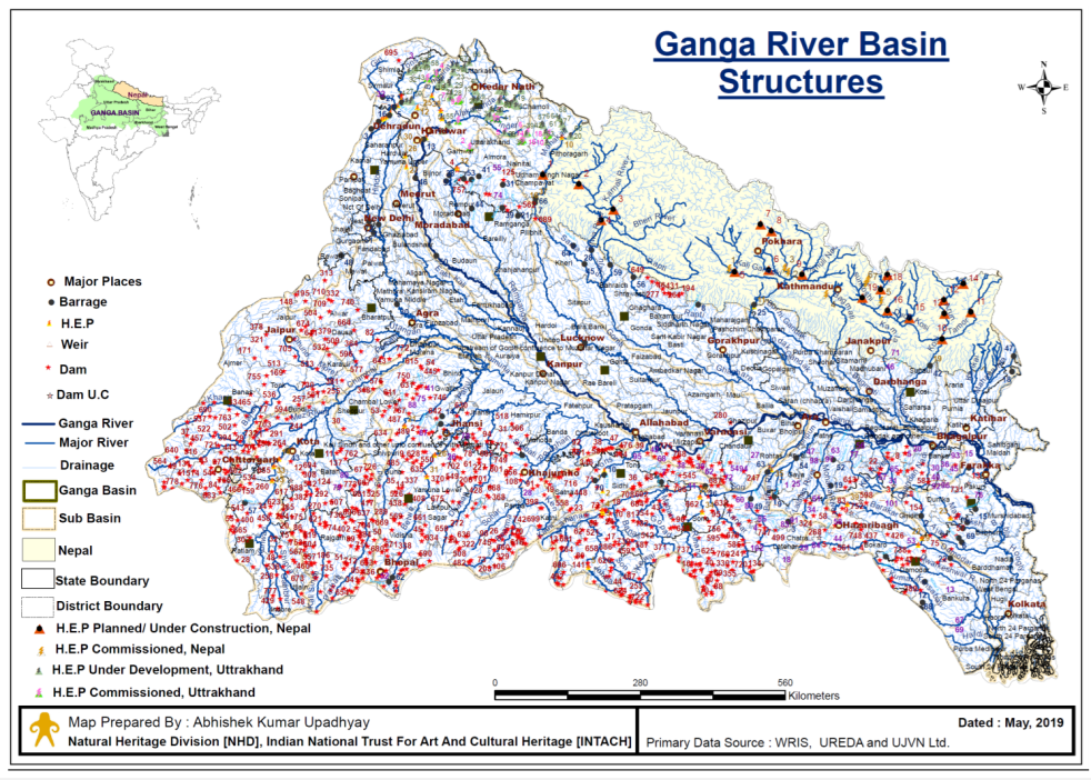
Why are we still building Large Dams?
Analysis of official information shows that Big dams are not longer necessary or viable or optimal in India. Most (over 95% of India’s 5701 large dams (5264 completed and 437 under construction as per CWC’s National Register of Large Dams[i]) are built for irrigation, but most of our irrigation now comes from groundwater. In fact, about 90% of additional irrigation in last four decades has come from groundwater.
Continue reading “Why are we still building Large Dams?”
DRP: 18 May 2020: Signs of Impending Dam Floods in SW Monsoon 2020?
These are rather ominous signs. As per the latest reservoir storage bulletin of Central Water Commission dated May 14, 2020, the 123 reservoirs monitored by CWC has massive, 64.6 BCM (Billion Cubic Meters) in live storage capacity, which is about 165% of the capacity on same date last year and average of last ten years, even as monsoon is just weeks away. Most dams known to create DAM INDUCED FLOODS in the past, including Bhakra dams (we wrote about it earlier this month: https://sandrp.in/2020/05/07/are-we-ready-to-use-more-water-from-snow-melt-in-indus-basin-this-year/), Narmada dams, Odisha and W Bengal dams (Cyclone AMPHAN is going to bring a lot of water here in next few days, even before the monsoon), Krishna basin dams, Cauvery basin dams, Bansagar and Gandhi Sagar Dams, and Kerala dams among others. All these dams have above average storage situation.
Continue reading “DRP: 18 May 2020: Signs of Impending Dam Floods in SW Monsoon 2020?”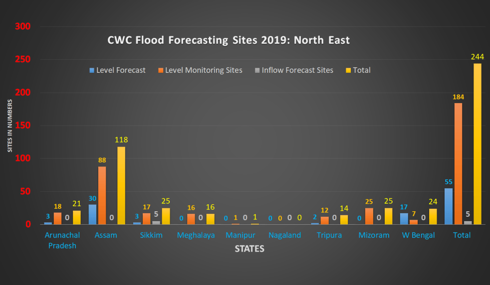
Overview of CWC’s Flood Forecasting Sites 2019: North East India
Central Water Commission (CWC) monitors water level at several hundred sites in the country during monsoon every year. It publishes this information on its Flood Forecast (FF) website[I]. The website has three ways to get this information: Data Flow Map, List Based Exploration, and Hydrograph view. The Hydrograph view provides information for past 72 hours, supposed to be updated every hour. This is in addition to the list of current forecasts.
The CWC’s FF website had in 2018 monsoon, information about 226 Flood Forecast Sites in the country comprising of 166 Level Forecast Sites and 60 Inflow Forecast Sites. It also monitors 700 Flood sites, information made available through List Based Exploration and Hydrograph View. As reported below, the number of sites have gone up during 2019 monsoon, which is welcome. However, most of the new sites, along with some old ones do not have key information.
Continue reading “Overview of CWC’s Flood Forecasting Sites 2019: North East India”

DRP: 5 Nov 2018: More Reports on Failure of Namami Gange Program
(Feature image showing preparation of Kumbh 2019 at Prayagraj by Siddharth Agarwal of Veditum)
EDIT article in SCIENCE magazine by TUSHAR SHAH and others on Ganga: “The quickest, cheapest, and most effective way for Mr. Modi to show a less polluted Ganga by 2019 would be operating dams and barrages in the Ganga basin with the sole objective of augmenting river flows. This would be a start to controlling discharge of untreated sewage and industrial waste, which will take a long time.” http://science.sciencemag.org/content/362/6414/503 (2 Nov. 2018)
DOWN TO EARTH says about Ganga: “the river will continue to run as – and even more – polluted as ever… Till August 31, 2018, only a little more than a quarter of the total number of projects sanctioned under it (Namami Gange) had been completed… according to CPCB’s Water Quality Map, only five out of the 70-odd monitoring stations on the river had water that was fit for drinking; only seven had water that was fit for bathing…”
-“Down To Earth quotes a study report and CPCB data to say that the actual measured discharge of wastewater into the Ganga is 123 per cent higher than what has been estimated…”
-“Numerous hydroelectric projects on the Bhagirathi and Alaknanda have turned the upper stretches of the Ganga into ecological deserts, says the Down To Earth assessment. The baseflow amount of the river has decreased by a huge 56 per cent in 2016, as compared to the 1970s.”
– “about 180 MLD of sludge will be generated in the five Ganga Basin states (Uttarakhand, Uttar Pradesh, Bihar, Jharkhand, West Bengal) when they become ODF. If proper sludge management is not done, this would invariably pollute the Ganga. What should cause further concern is that faecal sludge is a bigger pollutant than sewage – while BOD of sewage is 150-300 mg/litre, that of faecal sludge would be 15,000-30,000 mg/litre.” https://www.cseindia.org/ganga-may-not-flow-clean-in-the-near-future-says-new-analysis-9085 (30 Oct. 2018)
Meanwhile, a new CAG report reveals that almost 26 million litres of untreated sewage still flows into the Ganga every day in Uttarakhand. https://www.downtoearth.org.in/news/water/uttarakhand-has-failed-to-rejuvenate-the-ganga-through-namami-gange-62027 (2 Nov. 2018)
Continue reading “DRP: 5 Nov 2018: More Reports on Failure of Namami Gange Program “
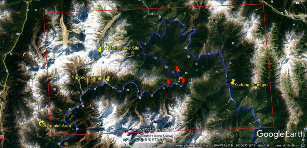
Another Landslide Dam on Yarlung Tsangpo raises more questions
On Oct 29, 2018, another landslide dam blocked the path of Yarlung Tsangpo Dam, reportedly at the same location as the Oct 17,2018 landslide dam[i]. It breached on Oct 31, without any reported major calamity, but these repeated occurrences, twice in two weeks and third time in ten months (if we include Dec 2017[ii] landslides) raises a lot of questions. The silence of government of India institutions about the possible causes or other analysis, including by Central Water Commission, Union Ministry of Water Resources, National Disaster Management Authority or even National Remote Sensing Agency has, as expected, raised questions and speculations in Arunachal Pradesh. Continue reading “Another Landslide Dam on Yarlung Tsangpo raises more questions”
Muddy Siang is sign of danger ahead, wake up call for Indian authorities
The current ongoing episode of Muddy Siang River water in Arunachal Pradesh is due to landslides in the upstream Tibet, triggered by the earthquakes starting on Nov 17, 2017 or possibly earlier. This is revealed by the satellite pictures and work of two researchers, first published in Arunachal Times on Dec 21, 2017[i]. These landslides are partly blocking the Siang flow and could lead to massive floods in the downstream Arunachal Pradesh and Assam any day.
A similar event in year 2000 led to sudden, massive floods in Siang River in Arunachal Pradesh on June 1, 2000. That episode, like the current one, started about 53 days before the floods, on April 9, 2000 due to landslides along a tributary of Yarlung Tsangpo, as Siang is known in Tibet. Continue reading “Muddy Siang is sign of danger ahead, wake up call for Indian authorities”
