FANTASTIC piece of work that shows how Ministtry of Finance, NITI Ayog, MoWR and MoEF raised objections to the National Waterways bill, but it was bull dozed by Gadkari, without even sharing the comments with cabinet.
पोत परिवहन मंत्रालय को यह चेताया गया था कि व्यापक विचार-विमर्श के बिना किसी जलमार्ग को राष्ट्रीय जलमार्ग घोषित करना सही नहीं होगा. इतनी बड़ी संख्या में राष्ट्रीय जलमार्ग विकसित करने पर न सिर्फ केंद्र सरकार पर आर्थिक बोझ पड़ेगा बल्कि पर्यावरण को भी गहरा नुकसान होगा, जिसे कभी ठीक नहीं किया जा सकता है. द वायर द्वारा सूचना के अधिकार (आरटीआई) के तहत प्राप्त किए गए आधिकारिक दस्तावेजों से ये खुलासा हुआ है कि वित्त मंत्रालय ने एक ही बार में इतने सारे जलमार्गों को राष्ट्रीय जलमार्ग घोषित करने के फैसले को लेकर कड़ा ऐतराज जाहिए किया था.फाइल नोटिंग और आधिकारिक पत्राचारों की करीबी जांच से यह भी पता चलता है कि वित्त मंत्रालय की टिप्पणियों को केंद्रीय कैबिनेट के सामने विचार के लिए रखा ही नहीं गया और कैबिनेट ने बिना इसके ही राष्ट्रीय जलमार्ग विधेयक, 2015 के प्रस्ताव को 25 मार्च 2015 को मंजूरी दे दी थी.
– देश के 106 जलमार्गों को राष्ट्रीय जलमार्ग घोषित करने के फैसले को लेकर केंद्र के दो प्रमुख विभाग नीति आयोग और वित्त मंत्रालय ने कड़ा विरोध जताया था.
– पांच फरवरी 2015 को भेजे अपने जवाब में नीति आयोग ने कहा कि जिन जलमार्गों को राष्ट्रीय जलमार्ग घोषित करने का प्रस्वाव रखा गया है, उसे लेकर ये चर्चा नहीं हुई कि आखिर किस आधार पर इन्हें राष्ट्रीय जलमार्ग घोषित किया जा रहा है.आयोग के यातायात विभाग ने अपने पत्र में लिखा, ‘सबसे पहले किसी भी नदी को राष्ट्रीय जलमार्ग घोषित करने के लिए कुछ व्यापक मापदंड जैसे कि उद्योगों से संपर्क, पर्यावरण प्रभाव आकलन, पूरे साल में पानी की मौजूदगी, नौपरिवहन इत्यादि तय किए जाने चाहिए.’
– जल संसाधन, नदी विकास एवं गंगा मंत्रालय ने 30 जनवरी 2015 को भेजे अपने पत्र में पानी की न्यूनतम गहराई बनाए रखने के लिए पानी की मात्रा का अनुमान लगाने की जरूरत बताई थी. मंत्रालय ने लिखा, ‘नौवहन के लिए प्रस्तावित नदी के हिस्सों/नहरों में पानी की न्यूनतम गहराई बनाए रखने के लिए पूरे वर्ष में एक सप्ताह/10 दिन के आधार पर पानी की मात्रा का अनुमान लगाने की आवश्यकता है ताकि पीने, सिंचाई और पानी की अन्य मांगों पर प्रभाव न पड़े.’जल मंत्रालय ने यह भी कहा था कि इस एक्ट का इस मंत्रालय की नदी जोड़ो परियोजना के साथ तालमेल होना चाहिए और किसी भी नदी में काम शुरू करने से पहले मंत्रालय के साथ मिलकर तकनीकी सम्भाव्यता रिपोर्ट तैयार की जानी चाहिए.
– इसके अलावा जल मंत्रालय और पर्यावरण मंत्रालय ने भी कुछ आपत्तियां जाहिर की थी. वित्त मंत्रालय के व्यय विभाग ने लिखा, ‘सभी अंतर्देशीय जलमार्गों को राष्ट्रीय जलमार्ग के रूप में घोषित किए जाने के लिए ऐसा एक ब्लैंकेट अनुमोदन भारत के संविधान की सातवीं अनुसूची के आधारभूत सिद्धांतों के विरुद्ध है.’वित्त मंत्रालय ने कहा कि सातवीं अनुसूची के अंतर्गत सभी तीनों सूचियों में अंतर्देशीय जलमार्ग निहित है जिनका आशय है कि केवल चयनित जलमार्गों को ही राष्ट्रीय जलमार्ग का नाम दिया जा सकता है जबकि अन्य राज्य जलमार्गों के रूप में प्रचलित किए जाने चाहिए.मंत्रालय ने आगे कहा, ‘जलमार्गों पर सड़क बनाने का नियम स्थापित करने के लिए इतनी बड़ी संख्या में जलमार्गों को राष्ट्रीय जलमार्गों के रूप में घोषित किए जाने की आवश्यकता नहीं है. कुछ चयनित जलमार्ग जिन पर सापेक्षिक रूप से अधिक यातायात होता है और भविष्य में इसमें पर्याप्त मात्रा में यातायात बढ़ने की संभावना होती है, को ही केवल राष्ट्रीय जलमार्गों के रूप में घोषित किया जा सकता है.’ https://m.thewirehindi.com/article/finance-ministry-niti-aayog-did-not-support-national-waterways-bill/94246 (13 Sept. 2019)
Jharkhand 485 families ‘displaced’, lose land, livelihood in Sahibgunj Not being able to address even the minimal social and environmental impacts. https://www.counterview.net/2019/09/jharkhand-riverine-terminal-485.html (11 Sept. 2019)
HYDRO POWER PROJECTS
Arunachal Pradesh After failed push, Govt begins scrapping dam projects CM inaugurating the State’s first community-managed mini hydroelectric project at Dikshi in West Kameng district on September 13, said his govt terminated 22 projects worth 3,800 MW while another 46 projects worth 8,000 MW had been served notices.
“These projects have not progressed and people have lost confidence in them. The government is reviewing the hydro-power projects periodically and action will be taken against the power developers found non-performing,” Mr. Khandu said.
About Kulsi Dam:- Meghalaya’s push for the Kulsi multi-purpose dam, declared a National Project, along the Assam-Meghalaya border, has unnerved the residents of 33 villages in Assam. The project has been in limbo for almost a decade, but a consensus between the Assam and Meghalaya governments has paved the ground for a detailed project report. The dam is proposed on the Kulsi, a river where the endangered Gangetic river dolphins from the Brahmaputra breed, near Ukiam, a village about 75 km west of Guwahati.
The proposed capacity of the Kulsi project has not been specified, but it entails a 62m high concrete dam on the inter-State border. The project is estimated to cost ₹1,460 crore and would affect 15.55 sq km of land in Assam and 5.75 sq km in Meghalaya due to reservoir submergence. “We cannot let our homes and farmlands be destroyed. The dam will be built over our dead bodies,” said J.R. Marak, the president of a committee involving all the villages. https://www.thehindu.com/news/national/other-states/after-years-of-hydro-push-arunachal-begins-scrapping-dam-projects/article29422880.ece (15 Sept. 2019)
– But at the same time Cabinet Committee’s clearance for Dibang Multipurpose Project and the NGT’s go-ahead for the Lower Subansiri project has revived anti-mega dam protests in downstream Assam. https://frontline.thehindu.com/social-issues/article29268855.ece (13 Sept. 2019)
Uttrakhand MATU PR: 10-9-2019 अलकनंदा हाइड्रो पावर लिमिटेड श्रीनगर बांध की लीकेज तुरंत समय सीमा में रोके राष्ट्रीय हरित प्राधिकरण ने हमारी (उत्तम सिंह भंडारी व विमल भाई) याचिका पर अलकनंदा हाइड्रो पावर लिमिटेड को आदेश दिया है कि वह श्रीनगर बांध की पावर चैनल में हो रही लीकेज को तुरंत समय सीमा के अंदर रोके। अपने आदेश में प्राधिकरण के मुख्य न्यायाधीश आदर्श कुमार गोयल जी, न्यायाधीश एसपी वागडी जी तथा विशेषज्ञ सदस्य नवीन नंदा जी ने अपने आदेश दिया कि “अलकनंदा हाइड्रो पावर कारपोरेशन लिमिटेड जल्दी ही समयबद्ध रूप में अग्रिम कार्यवाही सुनिश्चित करें जिसकी ऊर्जा विभाग टिहरी जिलाधीश तथा राज्य प्रदूषण नियंत्रण बोर्ड निगरानी करें।” (हिंदी अनुवाद को सुनिश्चित करने के लिए देखें अंग्रेजी आदेश संलग्न है।) https://www.facebook.com/sandrp.in/posts/2833226743371647?__tn__=K-R
Let us hope some action will follow. https://timesofindia.indiatimes.com/city/dehradun/control-water-leakage-from-hydro-project-in-time-bound-manner-ngt-directs-alaknanda-hydro-power-ltd/articleshow/71070761.cms (11 Sept. 2019)
Decisions of the Minutes of the MoEF’s Expert App Committee on River Valley Projects held on Aug 20, 2019:
- Bokang Bailing Hydroelectric Project (200 MW) at Pithoragarh, Uttarakhand by THDC Limited for ToR: TOR GRANTED
- Kaleswaram Lift Irrigation Scheme near Kannepally village, Mahadevpur Mandal, Jayashankar Bhoopalpally district, Telangana for Env Clearance: EC GRANTED
- Damanganga (Ekdare)-Godavari intrastate link project at Nasik district, Maharashtra for ToR: More Info Sought
- Damanganga–Vaitarna-Godavari Intrastate Link project by Nandpur, Madhyameshwar Project Division, at Thane district, Maharashtra for ToR: More Info Sought
- Renuka Dam Project (40 MW) in the district Sirmaur, by Himachal Pradesh Power Corp for Extn of EC: Granted for three years. If project not completed by Oct 2022, it will be considered de novo.
- Munjri Irrigation Project in Sheopur district of Madhya Pradesh for ToR: ToR GRANTED
- Banda Major Irrigation Project (CCA: 80,000 ha) in Sagar district of Madhya Pradesh for Env Cl: GRANTED EC
8 Parbati (Rinsi) major Irrigation Project in Rajgarh district of Madhya Pradesh for Env Cl: GRANTED EC http://environmentclearance.nic.in/writereaddata/Form-1A/Minutes/12092019TL9KQCMN26thEACMoM.pdf
Govt mulls merger of small power firms with NTPC, NHPC The ET NOW report said that NTPC or NHPC may takeover smaller power companies such as Tehri Hydro Development Corporation (THDC), SJVN and North Eastern Electric Power Corporation (NEEPCO). https://energy.economictimes.indiatimes.com/news/power/govt-mulls-merger-of-small-power-firms-with-ntpc-nhpc/71105291 (13 Sept. 2019)
DAMS
Sardar Sarovar Dam 16,000 oustee families to benefit if Centre ‘agrees’ on Narmada backwater level demand SHOCKING Act of CWC and BJP ruled MP govt that unilaterally decided that 15946 families do not have to be counted as affected! The Madhya Pradesh government has asked the Central Water Commission to reconsider the backward level of the Sardar Sarovar dam, which were revised in 2015.
The revision had “kept out” 15,946 oustee families out of the project affected areas, claiming, these would not suffer drowning. This was revealed during a meeting Narmada Bachao Andolan (NBA), with Madhya Pradesh government officials led by Narmada minister Surendra Singh Baghel in Indore. Based on the review of the backwater levels, the previous state government had talked of “zero balance” for oustees’ rehabilitation and resettlement (R&R). https://www.counterview.in/2019/09/16000-oustee-families-may-benefit-as.html (11 Sept. 2019)
Historic Chikhalda, temples, mosques submerged, activists ‘rescue’ Gandhi idol The first farmer of Asia was born in Chikhalda, if one is to believe archaeological researchers.
A historic village, 50 percent of its population is of Hindus and 50 percent of Muslims, yet it has always remained peaceful. Chikhalda has struggled to save water, land and people along Narmada river. https://www.counterview.net/2019/09/historic-chikhalda-its-temples-mosques.html?spref=fb&m=1 (16 Sept. 2019)
Tamil Nadu Undesilted dams a cause for concern The plea for desilting dams donot seem to have merit, but the key to create storages across the catchment. Barely four months ago, the state was staring at a drought situation. Now, every other reservoir is brimming with water and rivers are overflowing. Has the government learnt its lessons and doing enough to conserve surplus water to meet shortage in future? https://timesofindia.indiatimes.com/city/coimbatore/undesilted-dams-a-cause-for-concern/articleshow/71088491.cms (12 Sept. 2019)
Polavaram Dam No green clearance for Polavaram project-linked lift-schemes invites NGT red card The NGT on Aug 12, 2019 directed the Andhra Pradesh government to stall the existing lift irrigation schemes of Pattiseema and Purushottapatnam on Godavari river. The two lift projects are part of Polavaram major irrigation project cleared by the previous Telugu Desam Party government. The principal bench of NGT headed by Justice Adarsh Kumar Goel also stopped another lift irrigation scheme at Chintalapudi on Godavari river while hearing a petition by former Congress minister Vatti Vasanth Kumar and 12 others. It further directed the Andhra government not to proceed with the inter-linking of Godavari-Krishna-Penna river proposed during the TDP regime at a cost of Rs 84,000 crore.
– “The bench observed that none of these schemes had obtained necessary environmental and forest clearances. The government could go ahead with the projects only after obtaining necessary clearances,” senior advocate Sravan Kumar, arguing for the petitioner said. The NGT bench’s order was based on a report filed by the Joint Inspection Committee (JIC) constituted by the tribunal on May 30 this year. The JIC comprising officials from Central Pollution Control Board, Andhra Pradesh Pollution Control Board and MoEF submitted its report on June 28. https://www.hindustantimes.com/india-news/no-green-clearance-for-polavaram-project-linked-lift-schemes-invites-ngt-red-card/story-B9HciYf4lyI6CTZltzvXtO.html (13 Sept. 2019)
The Pattiseema lift irrigation scheme, which was a temporary project aimed at catering to one or two agricultural seasons, had become an expensive one, imposing a big burden on the exchequer for over four years on account of the electricity charges paid for it. https://www.thehindu.com/news/national/andhra-pradesh/polavaram-work-suspension-a-costly-mistake-says-sujana-chowdary/article29395092.ece (11 Sept. 2019)
Maharashtra BMC appoints consultant for Gargai project Last week, a proposal to appoint a consultant was passed in the Standing Committee. The civic body is going to spend Rs 5.23 crore on the project and the consultant is expected to prepare a detailed report on damage to trees due to dam water and submit a report to MoEF and Palghar district collectorate office to get the necessary permissions. The work is going to be completed in the next two years.
A senior official from the Water Supply Project department said, “Due to the dam project, about 1,100 hectares area will be affected. Over 1,000 families will have to move out of the dam site in Palghar district. The project will give additional 850 million litres water daily to the city. Once the dam is constructed, about 700 hectares of Tansa Wildlife Sanctuary will be affected. Considering these things, we will need to prepare a report for environment clearance.”
An official added, “The dam will affect thousands of trees as they all will go under water. The consultant will prepare a report on what kind of trees and how many will be affected. The extent of environment damage will also be assessed. The consultant will be responsible for getting the permission from Palghar collector office and environment ministry.” https://indianexpress.com/article/cities/mumbai/bmc-appoints-consultant-for-gargai-project-5998101/ (16 Sept. 2019)
INTERLINKING OF RIVERS
SANDRP Blog Fatal setback for Ken Betwa Link Project from CEC The Supreme Court appointed Central Empowered Committee (CEC) in a most path breaking, remarkable report on the Ken Betwa Link Project Phase I (KBLP-I), on Aug 30, 2019 has raised fundamental questions not only on the appropriateness of the Wildlife Clearance given to the project, but also the viability, optimality and desirability of the project. This a massive, fatal setback for the KBLP-I. This article tries to present the essence of the CEC report’s brilliant findings, not so strong recommendations and also includes some fantastic photos from the report. Please do read and Share. https://sandrp.in/2019/09/11/fatal-setback-for-ken-betwa-link-project-from-cec/ (11 Sept. 2019)

Hindi news covering CEC report on impact of Ken Betwa Link on environment, forest tiger population in Panna. http://pannastories.blogspot.com/2019/09/blog-post_9.html
RIVERS
Arunachal Pradesh River Sissar has run wild. Is the Trans-Arunachal Highway to blame? The careless dumping of debris has changed the river’s course, flooding paddy fields and orchards in Dambuk. The Trans-Arunachal Highway is ₹10,000-crore two-lane highway project that aims to connect Tawang in the west to Kanubari in the east of Arunachal Pradesh, and was conceived in 2008 and launched under the UPA regime. More than a decade since, major portions of the highway remain incomplete, with construction work often stalled due to natural threats of landslides and rains, and often due to man-made causes, including a failure to reach a compromise with landowners on financial compensation.
In the Siluk-Dambuk section, however, compensation was never an issue. Most landowners willingly parted with their land. Dambuk in Lower Dibang Valley district is cut off from the rest of the country for around six months each monsoon, so residents welcomed the prospect of actually driving over dry land instead of piggy-backing on elephants to cross River Sisseri (known as Sissar in the Adi language).
What residents did not foresee was how the project would impact their lives. It was when construction began that people began to suspect something was amiss. According to Ayem Modi, spokesperson of the Sissar-Sikang Preservation Committee (SSPC), they found that BIPL-ABL was dumping debris and mud from the earth-cutting into the river below, instead of in the designated dumping points.
SSPC, which consists of representatives from a cluster of villages, filed a complaint with the Pasighat division DFO, pointing out that the “illegal dumping” had led to the Sissar changing its course and endangering approximately 10,200 hectares of paddy fields in Dambuk and Bomjur. After ordering NHIDCL to stop construction, the DFO’s office conducted an inspection of the site. Last July, it dismissed the villagers’ complaints and allowed work to resume. The river, said the DFO, had not changed course. In fact, the inspection report even alleged that the complaints were made “to blackmail the contractor”. It asked the contractor to complete the road “as early as possible”.
The SSPC then filed a petition with the NGT. In April this year, however, the NGT too dismissed the petition in the face of concerted opposition from NHIDCL and the Pasighat DFO. The latter asked the village head of Aohali, located on the right bank of the river, to testify that the Sissar was following its normal course and nothing had changed, while BIPL-ABL denied there was any illegal dumping.
Then, this monsoon, Arunachal Pradesh saw unprecedented rains in June and July, and it became amply clear that the deposition of muck in the river now posed a clear and present danger. The Sissar had indeed changed course and was beginning to flow dangerously close to paddy fields in the adjoining villages. Saring saw his paddy field turn into a mini reservoir. “Around 90% of my field was flooded,” he says. His family’s orange orchard was also damaged when the river water came in.
Incidentally, it transpires that the Arunachal Pradesh State Pollution Control Board has been kept completely out of the loop of the road project. In a response to NGT, the Board said “this office is totally unaware of such activities and this leads to difficulty in monitoring of such projects.” It added that it would have to ascertain if any illegal dumping was indeed taking place. https://www.thehindu.com/sci-tech/energy-and-environment/river-sissar-has-run-wild-is-the-trans-arunachal-highway-to-blame/article29408626.ece (13 Sept. 2019)
NARMADA Study ‘Surface water availability down 8% in Narmada basin’ Major Indian river basins fed by rivers such as Brahmaputra, Cauvery, Ganga and Godavari have experienced reduction in surface water availability in the past 65 years, mentioned a doctoral study at IIT, Gandhinagar. The study, titled ‘Hydrologic Changes in Indian Subcontinental River Basins (1901–2012)’ by Dr Harsh Shah, mentioned that Narmada basin has reported similar reduction of 8%. On positive note, basin areas of Sabarmati, Mahi and Tapi have improved surface water by 13.8%, 9.6% and 6.8% for the period 1948 to 2012.
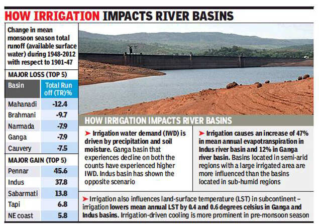
In another study, they found that anthropogenic activity such as irrigation influence water and energy budgets. They took into consideration the difference between natural (no irrigation) and irrigation scenarios and found that irrigation increases evapotranspiration by 48% and 22% over Indus and Sabarmati basins respectively. The study showed that between 1951 and 2012, irrigation water demand has increased in 12 out of 18 basins during post-monsoon season. Changes in irrigation water demand are largely driven by changes in soil moisture affected by summer monsoon precipitation, added the study. https://timesofindia.indiatimes.com/city/ahmedabad/surface-water-availability-down-8-in-narmada-basin/articleshow/71040099.cms (9 Sept. 2019)
Dammed and mined, Narmada River can no longer support her people -“The estuary of Narmada is extremely productive, particularly for Hilsa, but right now the hilsa fisheries has taken a hit, as nearly 60% of its production is down because there is no water is available there,” said river expert Parineeta Dandekar, of SANDRP, who has been researching on the Narmada valley for many years. “Hilsa needs a mix of saline and fresh water for breeding. Because we are holding all the water of river, no fresh water is coming down and fish can’t go up.” The estuary is downstream of the Sardar Sarovar Dam.
– Likewise, the famous Mahseer is also disappearing from many parts of Narmada. At Rajghat Kukra village, at the district border between Dhar and Badwani in Madhya Pradesh, 50-year-old Rajaram said that now he drives an auto-rickshaw to earn his living instead of fishing.
– “Hundreds of families were dependent on fishing here, but we hardly get any fish in the river now. It’s not more than one or two kg in a day. That isn’t sufficient to support a family,” said Rajaram. “So everyone is looking for other means of livelihood.”
– India is ranked second in inland fish production. More than 10 million people depend on sources like rivers, wetlands and ponds, and for the rural poor, a free flowing river is a lifeline. Experts say if small fishermen quit fishing, it also threatens the life of the river. “River fisherfolk are the best mascots of the health of the river because their livelihood is actually is related to how healthy is river is,” said Dandekar. https://india.mongabay.com/2019/09/dammed-and-mined-narmada-river-can-no-longer-support-her-people/ (2 Sept. 2019)
Revenue from Narmada waters double in 5 years For every 1,000 litres of Narmada water supplied, the state government charged Rs 3.14 from each residential consumer and Rs 25.95 from industries. The state’s revenues from distributing Narmada waters among farmers, residents and industries more than doubled to Rs 445.87 crore in 2017-18 compared to Rs 220.9 Cr in 2013-14. The govt charges Rs 328 from farmers per ha of land irrigated by Narmada water.
– The SSNNL official said, “The main reason is that Gujarat Water Infrastructure Limited (GWIL) – a state government arm – doesn’t regularly inform SSNNL about the purpose for which the Narmada water is being used. Sometimes there is a lack of clarity and this creates issue in billing.”
– The Gujarat’s water grid supplies 3,000 million litres of water per day – sourced from various rivers – to 47 million people in the state living in 11,220 villages and 171 towns. As far as Narmada river is concerned, SSNNL sits on top of the water grid and is primarily responsible for diverting the water from river to the main canals. Being a bulk supplier, SSNNL supplies water in huge quantities to GWIL which operates 2,684 km of bulk pipelines spread largely in Central, North and Saurashtra region of the state. GWIL in turn supplies to GWSSB (Gujarat Water Supply and Sewerage Board) which operates 1.20 lakh kilometers of distribution network which includes providing water to urban local bodies and to WASMO (Water and Sanitation Management Organisation) which as a facilitator for providing water to villages. https://indianexpress.com/article/cities/ahmedabad/gujarats-revenue-from-narmada-waters-doubles-in-five-years-5987242/ (12 Sept. 2019)
KRISHNA Telangana No Uranium mining in Amrabad Tiger Reserve forest: CM Asserting that the Telangana government is against uranium mining in Amrabad Tiger Reserve (ATR), CM K Chandrasekhar Rao on Sept. 15 said that an appropriate resolution would be passed in the Assembly and Council, expressing the opinions of both houses. He said the proposed exploration may contaminate river Krishna on which Hyderabad depends for drinking water and clarified that the state government had never accorded permission for uranium mining post June 2014 (four months after the new state came into being).
“We have no intention of allowing uranium mining… We will not allow Nallmala forests (where the tiger reserve is) to be destroyed. It will contaminate Krishna river from which we get drinking water. It will impact our capital city Hyderabad. So at any cost we will not allow uranium mining. This is our firm decision. I request the people of state not to worry about it.” Mr. Rao said that even if the centre insisted on going ahead with the exploration, the state would fight it unitedly. https://www.thehindu.com/news/national/telangana/no-uranium-mining-in-amrabad-tiger-reserve-forest-telangana-cm/article29423784.ece (15 Sept. 2019)
Andhra Pradesh Govt appoints panel to decide future of Amravati The expert committee has architects and city planners including Dr Mahaveer from School of Planning and Architecture, New Delhi, Dr Anjali Mohan, Urban and Regional Planner, Prof Shivananda Swamy, CEPT, Ahmadabad, Prof KT Ravindran, Delhi School of Architecture and Dr KV Arunachalam, Retd Chief Urban Planner of Chennai. The Committee shall also include an expert in environmental issues and flood management. The committee headed by retired IAS officer GN Rao has been given six weeks to submit its report.
After the recent floods in Krishna River, the state government had announced that Amaravati was not a safe place. There were reports suggesting that the state government is mulling the plans of creating four regional capital as the status of Amaravati remains uncertain. https://www.news18.com/news/india/andhra-govt-appoints-expert-panel-to-decide-future-of-capital-likely-to-increase-12-more-districts-2308423.html (14 Sept. 2019)
Today there’s hopelessness all around. Farmers want to return to agriculture but large-scale construction in the last four years has turned fertile lands barren. Moreover, they have been leveled, and infrastructure such as bore wells, drip irrigation systems, power connections are wiped out. Worse, the map is redrawn.
– “We cannot take up cultivation even if we want to,” said Shaik Subhani, who once owned three acres at Venkatapalem on the banks of the Krishna. These days he makes a
living selling bitter gourds by the roadside, which is almost always deserted. Even if land were to be returned, legal hurdles abound. https://timesofindia.indiatimes.com/articleshow/71093393.cms (13 Sept. 2019)
CAUVERY Tamil Nadu Govt sets up 16-member panel for restoration The state govt has set up a 16-member multi-disciplinary committee to implement the ambitious Nadanthai Vaazhi Cauvery to restore Cauvery and its tributaries on the lines of the Ganga Restoration and Rejuvenation. A committee headed by PWD secretary also visited New Delhi and held preliminary talks with the NMCG last week to kick start the multi-crore rupee program. The CM met PM Modi in June and requested financial support from the Centre and external funding agencies to the programme, which will cost about 7,000 crore to 10,000 crore.
The new committee is likely to entrust the work for preparing a detailed project report shortly to Water and Power Consultancy Services (WAPCOS) of the Union Jal Shakti ministry. The agenda is to have a multi-departmental approach for bio-diversity conservation, afforestation, cleaning of river surface, setting up STP, river front development and rejuvenation of the river and its main tributaries – Bhavani, Amaravathi and Noyyal. https://timesofindia.indiatimes.com/city/chennai/fruit-vegetable-farmers-in-a-soup/articleshow/71134812.cms (15 Sept. 2019)
GANGA Uttar Pradesh Floodplain set to be demarcated for 1st time State government has demarcated the Ganga’s floodplain and submitted a final report to the Jal Shakti ministry. The NMCG under Jal Shakti ministry would be the final authority to decide the floodplain. Once the report is approved, the centre would notify Ganga’s floodplain in the state for the first time.
In the first phase, the river stretch from Haridwar till Unnao has been covered. At least 200 metres from the embankment in the city and 500 metres from the embankment in rural areas might be marked as the river’s floodplain. A floodplain is the maximum area that a river has flooded in 25 years. Though the river may not rise that high every year but the demarcating it will mark the area that a river may engulf.
After the floodplain demarcated, it would further be divided into ‘no-development’ and ‘restrictive’ zones. The activities for each of the zones would be defined by the Centre and state government. If any activity is allowed in the ‘no development’ zone, it would be agriculture but on the condition that no fertilizer would be used, said sources in the state government. https://timesofindia.indiatimes.com/city/lucknow/gangas-floodplain-set-to-be-demarcated-for-first-time/articleshow/70877778.cms (28 Aug. 2019)
Photo Essay Ganga and its people
Travelling by foot along the Ganga, Siddharth Agarwal documents how the river is an intrinsic part of the life of the people that live beside it. https://www.thethirdpole.net/en/2019/08/28/photo-essay-the-ganga-and-its-people/ (8 Aug. 2019)
As per another report, nearly 4,400 Olympic-sized swimming pools worth of waste are released into the Ganges river daily https://gulfnews.com/world/asia/india/nearly-4400-olympic-sized-swimming-pools-worth-of-waste-are-released-into-the-ganges-river-daily-1.1568023003652 (9 Sept. 2019)
Jal Shakti Meanwhile the Union water minister said that that the notion “Ganga is polluted”, is wrong. “Ganga is one of the 20 rivers in world which comes under clean category. I don’t talk of rivulets, but of longest rivers stretching to around 2,500 km,” he added.
When there is clean water, there will be aquatic life with dolphins swimming in it, Ganga has dolphins which stay in cleanest river. Right from Gangotri to before reaching Gangasagar, its dissolved oxygen gets breached at two-three places only. Even in big cities like Kanpur and Unnao, BOD level rises but then turns normal.
… Ganga missions run earlier failed to bring in results because sewage treatment plants used to get closed as state governments had no money to run it. This model (new hybrid annuity model, one city one operator) shall run for 15 years and will bring results, he added. We will also be working on Ganga tributaries to clean Ganga, all tributaries such as Kali, Hindon, Bhagirathi will be cleaned in the process and the impact can be seen in next 2-3 years in a big way, he said. https://economictimes.indiatimes.com/news/politics-and-nation/notion-that-ganga-is-polluted-is-wrong-gajendra-singh-shekhawat/articleshow/71091782.cms
MoEF 1st catchment treatment plan for Ganga to meet climate goal; developed: Official Speaking at the 14th conference of parties (COP 14) to the United Nations Convention to Combat Desertification (UNCCD) being held at Greater Noida, Siddhanta Das, DG of Forests, MoEF, said that in order to fulfil its commitment to create additional 2.5-3 billion tonnes of carbon sink by 2030, India has developed its first catchment treatment plan for the river Ganga. The commitment to increase additional 2.5-3 billion tonnes carbon sink was made by India in the Paris Agreement in 2015 to fight climate change.
“The first such catchment treatment plan has been developed for the Ganges by the Forest Research Institute (FRI), and similar plans are being developed for nine major river systems by Indian Council for Forestry Research and Education (ICFRE),” Das said at a side event hosted by The Energy and Resources Institute (TERI). Speaking about agro and farm forestry, he further said, “India’s net annual import of wood and wood-based products is Rs 42,000 crore. Encouraging farmers to grow tree outside forests can enhance incomes and accelerate the carbon sequestration process.” https://economictimes.indiatimes.com/news/politics-and-nation/india-has-developed-first-catchment-treatment-plan-for-ganga-to-meet-climate-goal-official/articleshow/71101601.cms (12 Sept. 2019)
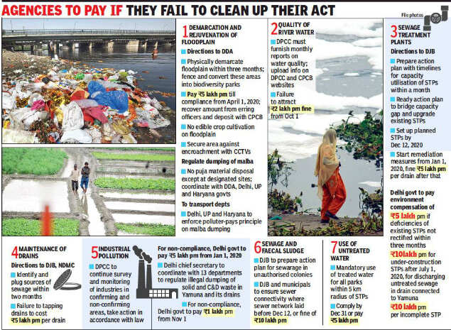
YAMUNA Delhi NGT ask DDA to begin demarcation of floodplains’ NGT has directed the DDA to undertake the process of demarcation of the Yamuna floodplains within three months and subsequently start work on the biodiversity parks. The green panel also directed the DDA to ensure that “no activity of edible crop or cultivation” on the floodplains takes place. The urban body was also directed to complete installation of CCTVs on the floodplains to prevent encroachment.
Additionally, the Delhi Pollution Control Committee (DPCC) was directed to furnish monthly reports on the water quality. “For failure to comply with this direction, the DPCC will be liable to pay environment compensation of ₹2 lakh per month to the CPCB for restoration of environment with effect from October 1, 2019. The amount can be recovered from the erring officers,” the Bench said. https://www.thehindu.com/news/cities/Delhi/begin-demarcation-of-yamuna-floodplains/article29395888.ece (12 Sept. 2019)
The tribunal set strict timelines for cleaning up the Yamuna through STPs. The DJB was told to complete the task of setting up STPs by December 31, 2020, and spell out an action plan with timelines within a month. The deficiencies of existing STPs should be rectified in three months, failing which an environmental compensation of Rs 5 lakh per month must be deposited with CPCB.
The fine will go up to Rs 10 lakh per month if work on STPs isn’t completed by July 1, 2020, the NGT said. DDA too will be liable to pay a penalty of Rs 5 lakh per month if it failed to comply with the direction by April 1, 2020, a bench headed by NGT chairperson Justice Adarsh Kumar Goel stated. The bench said the money was to be recovered from the erring officers.
The green bench asked DDA to strictly regulate dumping of malba and debris on the floodplain, asking for compensation to be collected wherever violations are found and submit action taken reports to the monitoring committee. “The transports departments of Delhi, Uttar Pradesh and Haryana need to enforce the ‘polluter pays’ principle so that no malba is dumped on the floodplain,” it said.
To ensure accountability, the green tribunal said monthly reports must be placed on the website of DPCC and CPCB. For failure to comply with this direction, DPCC will be liable to pay environment compensation of Rs 2 lakh per month to CPCB for restoration of environment with effect from October 1. The amount can be recovered from the erring officers, it said. The tribunal also asked DDA and the governments of Uttar Pradesh and Haryana to ensure that no puja or any other material is dumped in the river, except at designated sites. https://timesofindia.indiatimes.com/city/delhi/fence-yamuna-plains-make-it-bio-park-ngt/articleshow/71089590.cms (15 Sept. 2019)
NGT plans more time bound actions and directs DJB, DDA, MCD and other bodies in UP and Haryana to do the needful. Let us see how much implementation happens. https://timesofindia.indiatimes.com/city/delhi/lack-of-sewerage-has-killed-yamuna-ngt/articleshow/71087694.cms (12 Sept. 2019)
This year, the NGT-appointed monitoring committee of B S Sajwan and former Delhi chief secretary Shailaja Chandra is overseeing an anti-pollution approach of having the immersions in 116 artificial ponds. https://timesofindia.indiatimes.com/city/delhi/116-reasons-not-to-immerse-idols-in-yamuna-but-city-finds-a-way/articleshow/71088156.cms (12 Sept. 2019)
NGT order leaves Yamuna farmers clueless NGT’s directions came after two separate studies showed vegetables grown on the Yamuna floodplain were contaminated by toxic metals. NEERI analysed seven vegetables — cabbage, cauliflower, radish, brinjal, coriander, fenugreek and spinach — and established the presence of lead, nickel, cadmium and mercury. Lead was found to be above the safe limit of 2.5 mg/kg in all the samples and ranged from 2.8 mg to 13.8 mg/kg. The study by the CPCB too determined metal contamination, highlighting the presence of copper, lead and manganese in the Yamuna water and high levels of iron and manganese in the groundwater.
Manoj Mishra, convener of the Yamuna Jiye Abhiyaan, pointed out that NGT was only against the growing of crops for human consumption. “Horticulture and cultivation of non-edible crops can still be carried out,” he noted. “Though this is also only for those who have not encroached on the floodplain.” Mishra added that in 2017, the Supreme Court had given the Yamuna farmers two years to switch to non-food farming. DDA vice-chairman Tarun Kapoor claimed to have an action plan ready to remove any encroacher from the riverbank. “We will comply with all NGT directives and take action as required,” Kapoor said. https://timesofindia.indiatimes.com/city/delhi/ngt-order-leaves-yamuna-farmers-clueless-only-a-few-ready-to-shift/articleshow/71131197.cms (15 Sept. 2019)
Uttar Pradesh NGT Directs ADA To Demolish Encroachment On Yamuna Flood Plains By March 2020 The NGT, Delhi has directed the Agra Development Authority to clear the flood plain of river by ensuring removal of all encroachments by 31st March, 2020.The order came on a plea filed by petitioner Umashankar Patwa, seeking a direction to the authority concerned to conduct demolition of encroachment which has come up by way of construction in the river flood plain zone and river bed of the Yamuna and to restore it to its original state. https://www.livelaw.in/environment/ngt-directs-agra-development-authority-to-demolish-encroachment-on-yamuna-river-flood-plain-zone-147889 (8 Sept. 2019)
Chambal Cultural and Natural Heritage Temple in Chambal ravines stands out as ancient replica of Parliament House A replica of the Parliament House blossoms in an unnamed area in the ravines of the Chambal Valley in the Bhind-Morena region, which of late has earned disrepute for being home to dacoits. Far from political noise, the Chausath Yogini temple, which stands out as a replica of the Parliament House, is situated in the desolate Chambal Valley. It is a temple of Lord Shiva in reality but the Parliament House in New Delhi is apparently a replica of the structure, an argument which a section of archaeologists does not buy. https://www.business-standard.com/article/pti-stories/this-temple-in-chambal-ravines-stands-out-as-ancient-replica-of-parliament-house-119042900817_1.html (29 April 2019)
Exploring wildlife, heritage and spirituality in Chambal The pristine wilderness, unpolluted wildlife-supporting waters, vibrant bird-life, stunning landscapes, architectural gems; the temples and fair at Bateshwar; the heritage village of Holipura; the warm, friendly people; and the opportunity to experience a slice of rural India, is what Chambal is all about. https://www.thehindu.com/life-and-style/travel/exploring-wildlife-heritage-and-spirituality-in-chambal/article27001792.ece (1 May 2019)
Majestic view of Chambal Gorge from Kota’s Garadia Mahadev Temple Located near the pristine beauty of the Chambal River, the holy shrine boasts of the spectacular View Point which offers a panoramic scenery of the Chambal river, adjoining plains and gorges. The View Point and shrine are included in the Mukundra National park area.
Ardent nature lovers can sit at the view point for hours, absorbing the serenity and pristine beauty. Budding poets, writers and artists often look for inspiration by the still, blue waters and the surrounding wilderness. The temple area offers nature’s splendour and privacy. https://www.financialexpress.com/lifestyle/travel-tourism/enjoy-majestic-view-of-chambal-gorge-from-kotas-garadia-mahadev-temple-know-more/1663208/ (1 Aug. 2019)
FISH, FISHERIES, FISHERFOLKS
Maharashtra Social worker moves HC for fishing rights scheme in state A social worker has knocked the doors of the Nagpur bench of Bombay High Court for formulation of a policy for fishing rights in water bodies, village level tanks/ponds and minor irrigation tanks across Maharashtra. Petitioner Satyavrat Dutta has demanded amendment of the Maharashtra Fisheries Act, 1960, for the fisherman’s cooperative societies in light of the directives laid down in the ‘Global Code of Conduct for Responsible Fisheries, 1995’ as well as recommendations of a committee headed by an expert. https://timesofindia.indiatimes.com/city/nagpur/social-worker-moves-hc-for-fishing-rights-scheme-in-state/articleshow/71087585.cms (12 Sept. 2019)
SAND MINING
Karnataka Stakeholders in sand mining seek probe against IAS officer The Federation of Dakshina Kannada Lorry Owners’ Association, Sand Contractors, Sand Boat Owners, Workers and Construction Material Transport Lorry Owners Association on Sept. 8 sought a detailed probe into the role of former deputy commissioner Sasikanth Senthil in what they termed as serious violations in discharge of his duties as deputy commissioner. The ire of these associations is particularly focussed on his role in regulating sand trade in the district.
Rubbishing these allegations, Senthil told TOI that he does not even want to respond to the charges the office-bearers of the two bodies that have levelled allegations against him. “It is a well-known fact that I had chased away the one of the office-bearers of the association when he was involved in illegal act of sand mining and transportation, Senthil said referring to Surendra Kambli, adding the associations were free to go to town with their allegations. https://timesofindia.indiatimes.com/city/mangaluru/stakeholders-in-sand-mining-seek-probe-against-senthil/articleshow/71039396.cms (9 Sept. 2019)
‘Act tough against illegal sand extraction’ Minister for Mines and Geology C.C. Patil has issued a direction to officials to take all necessary steps to check illegal sand extraction in Gadag district. Chairing a meeting of the Gadag District Mining Task Force at the Deputy Commissioner’s office in Gadag on Sept. 11, the Minister asked the officials to be extra cautious in villages around Shirahatti, Mundargi, Laxmeshwar in the Tungabhadra river basin and in villages of Nargund taluk in the Malaprabha river basin. Mr. Patil directed tahsildars of the respective taluks to work in coordination with the officials of the departments of Public Works, Forest and Mines and Geology to ensure that there was no illegal sand extraction in the district. https://www.thehindu.com/news/national/karnataka/act-tough-againstillegal-sand-extraction/article29395399.ece (12 Sept. 2019)
Andhra Pradesh New policy overlooking green issues: EAS Sharma As per former Union Government Secretary and environmental activist EAS Sarma said, “The principle of sustainable sand mining is that the quantity of sand mined from a stretch in a year should not exceed the quantity deposited. In the absence of scientific studies, whatever policy adopted in a hurry is not going to help.”
He also said that Environmental Impact Assessment (EIA) should be conducted before allowing the quarrying or excavation, as per the Supreme Court’s past order, stating, “EIA should be done based not only on the likely impact of sand mining in a river stretch on the local environment but also on the basis of a scientific assessment of how much sand can be mined.” https://www.thenewsminute.com/article/explainer-all-you-need-know-about-andhras-new-sand-policy-108788 (12 Sept. 2019)
Telangana Mining policy unscientific: CPCB A recent inspection report by Central and Telangana State pollution control boards on desiltation conducted by the government in sand reaches along the Godavari River, highlights the lack of scientific validity and ecological sustainability in the State’s approach towards sand mining. The inspection report emphasises the need for the government to review its sand mining policy and align it on par with the Sustainable Sand Mining Guidelines of the Ministry of Environment and Forests.
The inspection was conducted along the 39-kilometre stretch of the Godavari, where the State government has been excavating sand as part of the ‘desiltation’ process, over an area of 1,400 hectares in 28 sand reaches under the submergence areas of Annaram and Medigadda barrages. As of June this year, 3.35crore cubic metres of sand have been excavated here. During inspection, it was found that although the thickness of the Godavari River was between 1.5 to 3 metres, excavation of sand was being conducted till a depth of 3 metres everywhere, with no scientific basis. This is harmful to the river’s ecology. http://www.newindianexpress.com/states/telangana/2019/sep/09/telanganas-sand-mining-policy-unscientific-says-report-2030936.html (9 Sept. 2019)
Tamil Nadu Plea against sand mining in Vaigai Madras HC has directed the authorities to consider the representation of a petitioner to prevent illegal sand mining in Vaigai river at Nilakottai taluk, Sithargalnatham village in Dindigul district. Petitioner R Muthukrishnan had moved the HC Madurai bench in this regard through a representation dated July 19.
A division bench of Justice T S Sivagnanam and Justice R Tharani observed that the materials placed before it are insufficient to issue a positive direction to prevent any mining activity. Furthermore, there is no specific averment made in the petition as to who are involved in illegal mining activities. If there is any infraction of rule or any illegal mining of river sand or savadu (alluvial soil), it goes without saying that the revenue officials have to take immediate steps to curb such activities, the bench said. https://timesofindia.indiatimes.com/city/madurai/plea-against-sand-mining-in-vaigai/articleshow/71088526.cms (12 Sept. 2019)
WATER OPTIONS
Rajasthan Local democracy is solving water issue People come together to dig community ponds in the desert. https://www.indiawaterportal.org/articles/how-local-democracy-solving-water-issues-southern-rajasthan (9 Sept. 2019)
Tami Nadu How Chennai is replenishing its water bodies Makkal Trust, a Coimbatore-based social welfare group, is taking small yet effective steps to desilt and restore waterbodies across Tamil Nadu. So far, the Trust has de-silted more than 10 waterbodies in Chennai, Coimbatore, Ariyalur, Thiruvarur and Namakkal. http://www.newindianexpress.com/cities/chennai/2019/sep/11/the-revivalists-this-is-how-chennai-is-replenishing-its-water-bodies-2031860.html (11 Sept. 2019)
GROUNDWATER
National NGT forms committee to stop illegal groundwater extraction A bench headed by NGT Chairperson Justice Adarsh Kumar Goel directed the committee to evolve a robust mechanism to ensure that groundwater is not illegally extracted and to monitor manning and functioning of the Central Ground Water Authority (CGWA). The committee comprises joint Secretaries of MoEF and MoWR, CGWB, NIH, Roorkee, National Remote Sensing Centre and CPCB. The green panel was hearing a plea filed by a city resident, Shailesh Singh, through advocates Preeti Singh and Sunklan Porwal, seeking action against depleting groundwater levels in the country and prevention of its illegal extraction.
The tribunal said despite a Supreme Court order in 1996 with regard to groundwater extraction, the water level has only gone down. In its order, the apex court had directed the central government to constitute a body to look into the issue of groundwater depletion. “Unfortunately, in spite of clear directions of the Supreme Court, the CGWA is not willing to take the ownership of the subject and repeatedly takes the plea that it does not have the infrastructure or that the responsibility of dealing with the problem is of the States and not that of the said authority,” the NGT said. “It is high time that the working of the CGWA is reviewed and remedial measures are taken, including assessment of suitability of the person to head it,” it said. https://www.moneycontrol.com/news/business/real-estate/ngt-forms-committee-to-stop-illegal-groundwater-extraction-4432031.html (12 Sept. 2019)
Centre We are extracting more, recharging less groundwater: Shekhawat Jal Shakti Minister Gajendra Singh Shekhawat, said that the government has launched water resources information system (WRIS) under which all states have been asked to give soil, moisture, ground water level, rain data etc. In fact, the major aim and objective of forming this integrated ministry is to tackle different water-related aspects from one point.
Shekhawat also expressed his worry on a lower water retaining capacity of India. He said, “We get 4,000 billion cubic water (bmc) from average rainfall and snow fall. We cannot use the entire snow as there are some evaporation losses. However, we still have 2,000 bcm water available with us which is harvestable. The water retaining capacity over the surface right from bigger dam to smallest reservoir is only 250 bcm.”
If we link all water bodies across India, then 50 bcm is our actual water retention capacity. We have total drinking water requirement of 50 bcm, but we don’t even have that much harvesting capability which is posing a major challenge in front of us.In fact, while only 470 bcm water gets replenished underground, we withdraw 700 bcm overall. Hence, our withdrawal quantity is higher and deposit is less. So we need to balance it and work on it with multiple approach. https://economictimes.indiatimes.com/news/politics-and-nation/notion-that-ganga-is-polluted-is-wrong-gajendra-singh-shekhawat/articleshow/71091782.cms (12 Sept. 2019)
Punjab After floods, highly polluted groundwater in Jalandhar Tube wells in parts of flood-hit areas of Jalandhar have started pumping out blackish water, which in some areas has an unbearable smell. The pollution of groundwater will increase problems for villagers as possibility of pollutants entering the food chain has also increased steeply.
There was apprehension that groundwater would get contaminated after polluted water of the Chitti Bein got mixed with the Satluj during the floods in Punjab and this noxious and polluted water inundated scores of fields for many days. https://timesofindia.indiatimes.com/city/ludhiana/after-floods-highly-polluted-groundwater-in-jalandhar/articleshow/71106221.cms (13 Sept. 2019)
Andhra Pradesh Uranium doses seeping into Kadapa groundwater Dangerously high levels of uranium has been found in the groundwater near a mine that the Uranium Corporation of India Limited (UCIL) is operating in Kadapa district. Although UCIL officials have denied any uranium seeping into the groundwater, the APPCB has issued a show-cause notice to the corporation which reveals shocking numbers.
The showcase notice was issued on August 7. APPCB’s zonal office at Kurnool collected water from the monitoring borewells around villages in and around UCIL’s tailing ponds in Tummalapalle of Vemula mandal in Kadapa district. The APPCB notice states that groundwater in the villages of Mobbuchintalapalli, K K Kotta and Kannampalli are “badly affected due to the presence of high alkalinity and uranium concentration. High concentrations of both these parameters may be due to UCIL mining as they use the alkaline leaching method for producing sodium di-uranate.”
According to the clearance given by the Union ministry of forests and environment, the tailing ponds have to be lined properly to prevent groundwater contamination. The overflow must be collected, treated and recycled for the ore processing plant. It clearly says that no water must escape from the pond. “UCIL failed to line the tailing pond with 250-micron polythene layer as directed in consent for operation order of the PCB,” the notice says. UCIL replied that it had followed AERB guidelines. The tailing pond is thickened with appropriate clay material with desired thickness to attain the stipulated permeability. However, APPCB said UCIL should have lined the layer with polythene as extra precaution.
NGO Human Rights Forum’s Kadapa convenor, K Jayasree, told TOI, “An 11-member committee of the APPCB with experts inspected UCIL on September 9 and visited six affected villages a day later. Locals complained of skin disease, keen pain and itching lumps appearing on their bodies.”Many local residents have already approached APPCB, showing warts and lumps on their bodies, apparently after being exposed to the water. https://timesofindia.indiatimes.com/city/hyderabad/uranium-doses-seeping-into-kadapa-groundwater/articleshow/71088240.cms (12 Sept. 2019)
Karnataka Australian tech for better groundwater management in parched villages University of Agricultural Sciences-Bengaluru (UAS-B) has collaborated with Western Sydney University, Australia to take forward the project MARVI (Managing Aquifer Recharge and Sustaining Groundwater use through Village-Level Intervention) developed by the university to improve security of irrigation water systems by putting in place an effective participatory groundwater monitoring programme at the village level.
The project focusses on assessing the effectiveness of current rainwater harvesting methods and groundwater recharge structures. Based on such inputs, it will develop strategies to manage the demand in a sustainable manner, say UAS-B scientists. The approach of the project is to help farmers ensure that their dryland farming is not affected by shortage of water, and to make them understand the importance of groundwater management. https://www.thehindu.com/news/national/karnataka/australian-tech-for-better-groundwater-management-in-parched-villages/article29369871.ece (9 Sept. 2019)
Tamil Nadu Technology to clean sewage to recharge groundwater near Villivakkam lake BARC scientist J Daniel Chellappa said the hybrid granular SBR (sequencing batch reactor) process is a simple technology in which bio-beads made of natural microbes present in wastewater are used to adsorb the contaminants. “This is our latest sewage treatment technology, which we have patented. Only 50% of the investment needed for a conventional treatment plant is required for this and the land requirement too is less. A small plant can be set up and can be easily upgraded if needed,” he said after inspecting the Villivakkam lake and Mambalam canal to identify locations to set up the plant and determine the source of sewage in the surrounding localities, in the morning.
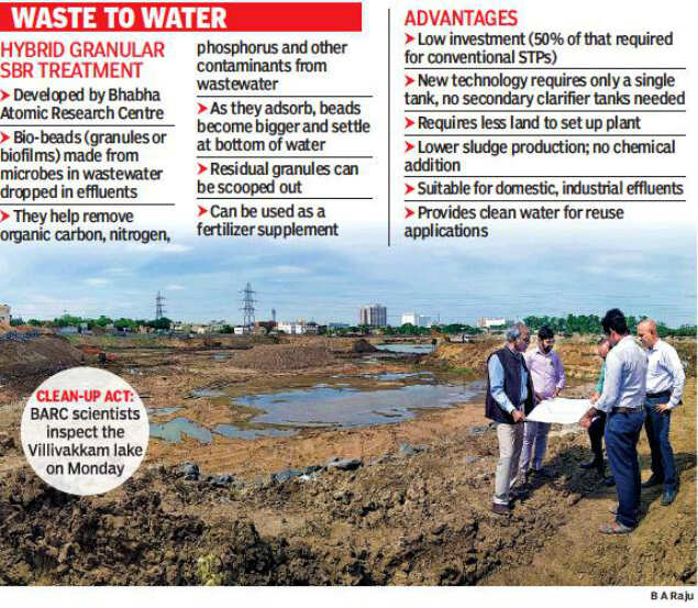
Unlike traditional sewage treatment plants that need membrane and tanks, the new technology comprises bio-beads which can be dropped into a tank of wastewater. In minutes, the beads will begin adsorbing the contaminants, including nitrogen and phosphorus, and turn into granules before settling at the bottom of the tank. The resultant granules can be easily scooped out and can be used as a fertilizer supplement, as they are a source of carbon, phosphorus and nitrogen. While the technology leaves reusable residue, the treatment process itself does not leave any odour unlike the traditional method.
Chennai Corporation officials, who were part of the inspection team, said a 5MLD capacity sewage treatment plant with BARC technology may be set up on a pilot basis and will be upgraded to 30MLD and eventually to other waterbodies under restoration. The plan is to let the treated water into the lake, so there will be water in the lake as well as groundwater throughout the year. The project would be part of the Smart City Mission under which the lake is being restored at Rs 16 crore. The 27.5acre lake has a storage capacity of 280MLD across 70,000sqm. At present, the lake is being desilted to a depth of about 4metres and recharge wells have been built on the lakebed. B R Saravanamurthy, executive engineer, storm water drain department, GCC, said, “The idea is to have water to the brim throughout the year while also letting it percolate and recharge groundwater levels up to a 5km radius.” https://timesofindia.indiatimes.com/city/chennai/tech-to-clean-sewage-to-recharge-groundwater/articleshow/71056293.cms (10 Sept. 2019)
Rajasthan Groundwater fouled by natural, human-made toxins As part of the Duke University India Initiative, researchers tested 243 groundwater wells, across the northwest Indian state of Rajasthan, the country’s largest state by area, to probe the presence of multiple contaminants in groundwater. They discovered that over three-quarters of the wells (tubewells or handpumps), that provide drinking water without any treatment, contains contaminants such as fluoride, nitrate, and uranium at levels that exceed both Indian and World Health Organisation (WHO) drinking water norms. A combination of geogenic (natural or geologic) and anthropogenic (or man-made) processes affect groundwater chemistry and quality in Rajasthan, said lead author Avner Vengosh of the Duke University. https://thewire.in/environment/groundwater-in-rajasthan-fouled-by-natural-and-human-made-toxins (12 Sept. 2019)
Uttar Pradesh In a first, Noida starts testing groundwater For the first time, the Noida Authority is testing the quality of the town’s groundwater. The move comes after repeated complaints from residents about the quality of water supplied in the city. The two agencies – Shree Ram Testing Laboratories and Centre for Environment and Food Technology Pvt Ltd, accredited by FSSAI and the Union environment ministry – will collect water samples from six ranney wells and 30 underground reservoirs.
In the first phase, a physiochemical and biological analyses of the groundwater will be done. A report is expected within two months, by the end of November. What has to be done next for improvement in water supply or quality will be decided on the basis of quality test reports. In the following phase, from December, random checks will be conducted on household water quality. If the water quality is found to be acceptable at the source but not the consumers’ end, the focus will be on strengthening the supply system – like replacing old rusting pipelines or fixing leakages. If the problem lies at the source, water treatment will be taken up on a bigger scale. https://timesofindia.indiatimes.com/city/noida/in-a-first-noida-starts-testing-groundwater/articleshow/71088121.cms (12 Sept. 2019)
Opinion A Water Uncertain Future India extracts 75 billion cubic meters of groundwater annually. This is approximately a third of the total groundwater mined globally – a stupendous amount with no parallels elsewhere in the world. It is estimated that groundwater utilisation in India has increased from 10-20 km3 to 240-260 km3 in the last 50 years.
Politicians are now touting the concept of interlinking all major rivers (inter-basin water transfers) as a geoengineering solution to the continued water depletion. By diverting river water, we are starving deltaic regions of freshwater that could have helped balance saltwater coming from the sea.
Alice Albinia, in her 2008 book Empires of the Indus narrates how a delta system at the mouth of Indus river – which was once “the richest in all Pakistan” – became impoverished when the British started their barrage construction, which Pakistan continued post-1947. Such examples are aplenty in India as well. The state of downstream parts of the Narmada river since the completion of the Sardar Sarovar Dam is a modern example in the making. https://thewire.in/environment/how-did-india-end-up-staring-at-a-water-uncertain-future (10 Sept. 2019)
Using water crisis as an opportunity Mexico, by the Nation’s Waters law of 1992, declared water as a national property and it became obligatory for all consumers to legitimise their rights through procurement of water leases. Big industrial and commercial water users were quick to apply for a lease. However, the real challenge was registering water rights of agricultural users, who withdraw 80% of the total groundwater and keep track on their extraction. If Mexico, with 0.09 million wells, found it difficult to enforce the law, we can imagine the situation in India (19 million wells) if we also declare groundwater a government property. https://www.financialexpress.com/opinion/using-water-crisis-as-an-opportunity/1697611/ (6 Sept. 2019)
1-size-fits-all method for groundwater recharge may not work in India: Experts Abhijit Mukherjee, associate professor of hydrogeology at IIT Kharagpur:- “A nationwide effort to artificially recharge the groundwater has started under MNREGA programme and parched water harvesting structures across the country is getting reviewed. The propositions are “in good spirit and intent” but have not kept in mind the scientific principles that govern groundwater recharge.
Water resource availability is extremely heterogeneous and largely dependent on the topography, geological — soft sediment or hard rock — and climatic setup (mostly as rainfall) for an area, along with human usage, mostly for food production through irrigated agriculture. Groundwater storage is influenced primarily by a very delicate balance of certain factors, which needs a detailed scientific evaluation and understanding.
Explaining these factors, Mukherjee said, “Every year, the groundwater of an area is typically recharged by rainfall, particularly during the monsoon.” However, the process of subsurface recharge is very slow.
“Depending on the depth of the wells, these waters could have recharged hundreds and thousands of years ago. Further, the excess water from the rainfall and floods does not get recharged into groundwater because of the geology and physics of the areas,” Mukherjee said. For example, groundwater in Kolkata or Patna gets recharged about a hundred kilometres away. Hence, in a human-time scale the groundwater we extract is theoretically a non-renewable resource, Mukherjee said.
Groundwater rejuvenation has been reported in parts of Gujarat, Andhra Pradesh, and Madhya Pradesh. Mukherjee attributed this to the implementation of ingenious groundwater management strategies in both public and private sectors. But he warned against cheering for these too soon. “All areas do not have the same topographic-geological-climatic setup of Gujarat or Andhra Pradesh, which is why this country-scale artificial recharge has several scientific issues,” Mukherjee said. Further, the groundwater and river water in an area are in a very delicate balance that is maintained by the physics of the water. Any plan to augment the groundwater would also have serious implications for rivers in the vicinity. https://timesofindia.indiatimes.com/india/one-size-fits-all-method-for-groundwater-recharge-may-not-work-in-india-experts/articleshow/71094501.cms (12 Sept. 2019)
URBAN WATER
Chennai Wait for Krishna river water gets longer Krishna’s water supply to Chennai remains as elusive as ever, as it will take 10-15 days for the city to start receiving its share, said officials from the Water Resource Department (WRD).Though the 2 main reservoirs across Krishna river in Andhra Pradesh, Srisailam and Somasila, have crossed the mark of transferrable water levels, the third reservoir, Kandaleru is still not full. As on Sept. 11, Kandaleru had stored 3.6 thousand million cubic feet (tmcft) of water while 6.4 tmcft is needed to transfer water to the city.
As per the Telugu Ganga project signed in the 1980s between Tamil Nadu and Andhra Pradesh, the latter is mandated to provide 12 tmcft in a year, to meet Chennai’s drinking water needs. This water is stored in Poondi and Red Hills reservoir after crossing the zero point at Uthukottai. Between July and October, the city is supposed to receive 8 tmcft of water and the remaining 4 tmcft between January and April. But due to poor storage levels in their reservoirs, Chennai’s share is yet to be fulfilled. The last spell of 4 tmcft also was not fully given as Kandaleru reservoir had gone dry in February. http://www.newindianexpress.com/cities/chennai/2019/sep/13/chennais-wait-for-krishna-river-water-gets-longer-2032765.html (13 Sept. 2019)
This report wrongly pushes for more dams on Caurvery to meet Chennai drinking water demand. The heavy outflow of 70,000 cusecs from Mettur reservoir has brought jubilation among the farmers in the delta districts. The water level crossed the full-reservoir level of 120 ft and stood at 121 ft on Sept. 9. Nine Cauvery basin districts have been sounded flood alert since Sept. 7. People have been advised not to take bath in the river and those living in low-lying areas have been shifted to rescue shelters.
The reservoir had 94.926 tmc ft water. It could take another 3 ft of water, but for safety reasons, PWD released more than the inflow (66,000) through various systems. While 1,000 cusecs was diverted for drinking water supply, another 900 cusecs was released into canals. The water that gushed out of Mettur on Sept. 9, if fully tapped, would have sufficed to quench the thirst of Chennai city for more than six months. This is the 43rd year that Mettur dam is reaching its full level. Last year too, the dam had reached its full level. https://timesofindia.indiatimes.com/city/chennai/wasted-cauvery-water-could-have-quenched-chennais-thirst-for-six-months/articleshow/71056296.cms (10 Sept. 2019)
MONSOON 2019


National India received 782 mm of rain against monsoon average of 764.5 mm till date According to the rainfall data available with Skymet from 1 June – 8 September, the country has so far received 782 mm of rainfall against the normal of 764.5 mm. After good rains, the South Peninsula now has a surplus of 11 percent, a 4 percent jump in just one week. East and North East India have been the most rain deprived region, facing a deficiency of 20 percent. https://www.firstpost.com/india/india-received-782-mm-of-rain-against-monsoon-average-of-764-5-mm-till-date-central-region-gets-19-surplus-while-east-north-east-face-20-deficiency-7308981.html (9 Sept. 2019)
Karnataka South West Monsoon will soon withdraw In the month of August the Karnataka has received an excess rainfall of 80 per cent, breaking a 118 years record. https://bangaloremirror.indiatimes.com/bangalore/others/south-west-monsoon-monsoon-will-soon-withdraw/articleshow/71039347.cms (9 Sept. 2019)
Maharashtra Mahabaleshwar has been wetter than Mawsynram, the wettest place on Earth, this monsoon. It received 7,175.4mm rain as against Mawsynram’s 6,218.4mm from June 1 to Sept 4, data with the India Meteorological Dept shows. Cherrapunji received around 6,082.7mm in the same period. Mahabaleshwar outperformed Cherrapunji last year. Patharpunj in Patan taluka in Satara has also recorded 7,000mm rainfall during this monsoon, J R Kulkarni, chairman of the India Meteorological Society, Pune Chapter (IMSP), told TOI. https://timesofindia.indiatimes.com/city/pune/mahabaleshwars-rain-count-trumps-that-in-worlds-wettest-place/articleshow/71001981.cms (6 Sept. 2019)
Bundelkhand Assessment of rainfall variability and its impct on groundnut yield Bundelkhand region, one of the vulnerable areas in central India, is prone to frequent drought and crop failure due to annual rainfall variability. In this study, long-term (113 years) fine resolution (0.25° × 0.25°) daily gridded rainfall data has been analysed to depict a spatial variation of annual rainfall over Bundelkhand.
An increase in annual rainfall has been observed from north to south of the study area. A declining trend varying from 0.49 to 2.16 mm per year is observed in annual rainfall time series in most parts of the study area. Trend analysis of monsoon rainfall shows overall declining trend over the study area. https://scroll.in/video/936488/eco-india-the-women-farmers-in-maharashtra-who-are-fighting-for-their-right-to-own-land (10 Sept. 2019)
FLOOD 2019
Protect forests to fight floods This article makes an important point: Protect forests in the mountains to reduce floods. The suggestion that dam safety bill may help reduce dam induced floods is without merit though. https://theconversation.com/india-must-stop-deforesting-its-mountains-if-it-wants-to-fight-floods-122669 (10 Sept. 2019)
SSP FLOODS NARMADA Narmada dam set to overflow at its highest level for first time Gujarat’s Narmada dam is set to overflow at its full 138.68-metre height for the first time, after it was completed with the installation of gates in 2017, amid State-wide celebrations the government has planned to mark the event. As on Sept. 14 5 PM, the level was at 138.14 metre, just 54 cm below the highest/overflow point.
Sardar Sarovar Narmada Nigam Ltd (SSNNL) Managing Director Dr. Rajiv Kumar Gupta said, “Sardar Sarovar Dam: further storage necessary to control flood situation in Bharuch city due to high tide and 175 villages in three districts. The district administration requested to control outflow. Level touched historic mark 138 metres today.
“For it to reach the full height will depend on technical and natural factors,” he said. “With large amounts of water being released from the Omkareshwar and the Indira Sagar dams in Madhya Pradesh, the dam is receiving heavy inflow.”
As per the details shared by the Narmada Flood Control room, the inflow was 8,94,730 cusecs, the outflow 6,30,444 cusecs and 23 gates were open up to 3.9 meters. After the installation and closure of 30 gates in 2017, its maximum height increased from 121.92m to 138.68 m. More than 3,500 people from 23 villages and some areas of the Bharuch district were shifted to safer locations. https://www.thehindu.com/news/national/narmada-dam-set-to-overflow-at-its-highest-level-for-first-time/article29418453.ece (14 Sept. 2019)
Tremors continue to jolt villages along Narmada as Sardar Sarovar fills up At 4.45 a.m. on Sept. 11, when a blast ripped through the air of Ekalbara, sending reverberations across, all its terrified residents poured into the village square and remained there for an hour. The 153 families of the village in Dhar district, facing submergence due to the swelling backwaters in the Narmada, had felt the tremors for the second time in the day. Earlier, on September 7 and 9, tremors had again rocked them out of sleep.
Terror has gripped more than 12 villages in the Barwani district, and in Ekalbara in Dhar district, as tremors measuring up to two on the Richter Scale have been experienced there since August. This has coincided with the filling up of the Sardar Sarovar Dam, downstream in Gujarat, to its full reservoir level of 138.68 metres for the first time, to test its integrity. Though the dam should be filled up only by October 15, the level had already reached 138.34 metres on Sept. 15.
“The blasts are so loud that they could be heard even 6-7 km away. It’s like one you’d hear from a mine, that’d send birds flying away,” said Bharat Mandloi, 38, a farmer from Ekalbara. “Even at the site of rehabilitation, tremors are being felt. We’ve never experienced them in the region before.” Stating that an expert from the Geological Survey of India had been called to study the phenomenon, Dhar Collector Srikanth Banoth said, “Anyway, the village has been evacuated as it has been submerged by the backwaters. The tremors were light and ranged between two and three on the Richter scale.” https://www.thehindu.com/news/national/other-states/tremors-continue-to-jolt-villages-along-narmada-as-sardar-sarovar-fills-up/article29425372.ece (15 Sept. 2019)
Flood alert in 3 districts as Narmada dam level touches 136m The state government on Sept. 9 issued an alert for villages near Narmada river after the water level in the Sardar Sarovar dam crossed 136 metres, the highest since its height was raised to 138 metres in 2017. Sardar Sarovar Narmada Nigam Limited (SSNNL) took the decision to release the water due to continuous rainfall in the upstream catchment area in Narmada basin and release of water from Omkareshwar Dam in Madhya Pradesh
The control room informed that the dam was getting 6.47 lakh cusec (cubic foot per second) of water of which a 6.16 lakh cusec was being released into the river by opening 23 of the 30 gates of the structure. https://timesofindia.indiatimes.com/city/ahmedabad/flood-alert-in-three-gujarat-districts-as-narmada-dam-level-touches-136m/articleshow/71059509.cms (10 Sept. 2019)
114 dams put on high alert after heavy rain As per update, out of the 204 reservoirs in the State, 114 dams were put on ‘high alert’ with over 90% filling. The Sardar Sarovar dam on Narmada river, whose full capacity is 138.6m, was also put on high alert with water level at 136m. It is expected to touch full capacity soon, as the heavy inflow continues, following fresh rains in upper catchment areas in Madhya Pradesh. The authorities released more than a million cusec water from the reservoir. As a result, more than 200 villages in Narmada, Bharuch and Vadodara districts have been put on alert.
Gujarat has so far received total rainfall of 926.59 mm, which is 13.5% more than its Long-Period Average (LPA) of 816 mm. This year, rainfall picked up in August, when it received 446 mm rainfall. So far in September, the State has received 150 mm rains. Rainfall received during the first two months of monsoon, June and July, were 109mm and 222mm respectively. IMD-Ahmedabad Director Jayanta Sarkar said that the highest rain in Gujarat in this decade in any one year was in 2013 when it was a record 148%. https://www.thehindu.com/news/national/other-states/114-dams-on-high-alert-in-gujarat/article29385669.ece (10 Sept. 2019)
DAM FLOODS CHAMBAL MASSIVE DISASTER COULD BE UNFOLDING AT GANDHISAGAR DAM AND DOWNSTREAM AREAS IN MP, RAJASTHAN ALONG CHAMBAL RIVER AND FURTHER DOWNSTREAM. https://twitter.com/CWCOfficial_FF/status/1172928351289278465

UNPRECEDENTED: RIVER CHAMBAL HAS CROSSED HFL 217.685 M SET ON 2 Sept. 2006 BY ~8 M AT KOTA BARRAGE, RAJASTHAN; STILL FLOWING ~225.800 M.:- http://14.143.182.4/ffs/hydrograph/
After a sudden rise in the water level of the Chambal river on Sept. 14, six labourers trapped in a container were washed away near Bhind-Dholpur border. The labourers were working at the railway construction site in Rajkheda area at the time of the incident. Later, they were rescued by the local people. https://timesofindia.indiatimes.com/city/jaipur/rajasthan-six-labourers-washed-away-in-chambal-river-rescued/articleshow/71135710.cms (15 Sept. 2019)
Army moved in to Madhya Pradesh as dam overflows The government has moved in the Army to assist officials in evacuating villagers from areas facing submergence due to the swelling backwaters of the Chambal river in Bhind and Sheopur districts. As on Sept. 15, Madhya Pradesh had received 33% more rain than normal, with the western district of Mandsaur receiving 160% more rain. However, Sidhi and Shahdol districts stare at drought.
In Uttar Pradesh, major rivers are in spate and some of them are flowing above the danger mark due to release of water from various dams, official sources said in Lucknow on Sept. 15. According to a CWC report, the Ganga is flowing above the danger mark in Ballia and Ghazipur. In Varanasi, Allahabad and Badaun, the water level in the river is nearing the danger mark. Similarly, the Yamuna is flowing above the danger mark in Hamipur and Chillaghat (Banda); the Betwa river is above the red mark in Hamirpur. https://www.thehindu.com/news/national/other-states/army-moved-in-to-madhya-pradesh-as-dam-overflows/article29425314.ece (15 Sept. 2019)
Gandhisagar Dam reaches max levels, disaster management agencies alerted The Gandhisagar Dam on Chambal river in Madhya Pradesh’s Neemuch district reached its maximum water level on Sept. 14 following days of intense rainfall in the region. The Central Water Commission Official Flood Forecast’s Twitter handle deemed the prevailing situation at the Gandhisagar Dam as a ‘crisis’ and warned disaster management agencies to stay alert. https://zeenews.india.com/india/mps-gandhisagar-dam-reaches-max-levels-disaster-management-agencies-alerted-2234490.html (14 Sept. 2019)
Flood-like situation in Madhya Pradesh, Rajasthan More than 16,000 people from Madhya Pradesh’s Mandsaur and Neemuch districts were shifted to safer places on Sunday after heavy rainfall caused water-logging in several areas, while parts of Pratapgarh district in Rajasthan faced a flood-like situation due to a rise in the water-level of the Jakham and Mahi rivers following incessant rains.
In Madhya Pradesh, heavy showers have been lashing the two neighbouring districts in the western part of the state for the last few days, crippling normal life. Nearly 2,300 people were evacuated from the flooded Rampura town in Neemuch after an alarming rise in the backwater level of Gandhi Sagar Dam in Mandsaur, an official at Neemuch collectorate said.
After heavy rains, 19 sluice gates of Gandhi Sagar Dam were opened and 4.93 lakh cusec water was being discharged, the dam project’s sub-divisional officer NP Dev was quoted as saying by reports. The released water reportedly gushed downstream and entered parts of Rajasthan bordering the district.
More than 350 students and 50 teachers were stuck at a school in Chittorgarh since Saturday, as roads were blocked due to heavy discharge of water from Rana Pratap Dam. Locals on Sunday were providing immediate assistance and food to those stuck, ANI reported. https://www.firstpost.com/india/flood-like-situation-in-madhya-pradesh-rajasthan-as-imd-predicts-heavy-rains-for-next-2-days-13000-evacuated-from-mandsaur-neemuch-after-downpour-hits-districts-7342141.html (15 Sept. 2019)
Floods In Rajasthan After Release Of Water From Dams, Thousands Evacuated Large areas in several districts of Rajasthan were flooded after water was released from dams, forcing evacuation of thousands of stranded people, including school children.
In Chittorgarh’s Rawatbhata town, efforts are being made to evacuate 318 children and 25 teachers of a private school, who got stranded after water was released from 17 gates of the Ranapratap Sagar dam on Sept. 14. The weather office has predicted heavy to very heavy rainfall in Baran, Chittorgarh, Jhalawar and Kota districts during the next 24 hours.
Kota is facing an unprecedented situation as it is the first time since the construction of the Gandhi Sagar dam that a record 6.93 lakh cusecs of water has been discharged from 19 gates of the Kota Barrage in a day, Kota district Collector Muktanand Agrawal told reporters. Over 5,000 people have been evacuated so far in Kota and teams are conducting operations to rescue those stranded and take relief to the affected, officials said. He said more water is likely to be discharged from the Gandhi Sagar dam which is currently overflowing at 1,314 ft and needs to be brought down to 1,308 ft.
The downstream localities in Kota city were the worst affected by the deluge, as water reached even the second floor of houses and people were taking shelter on the third floor of buildings to save themselves, officials said. https://www.ndtv.com/india-news/floods-in-rajasthan-after-release-of-water-from-dams-thousands-evacuated-2101383 (16 Sept. 2019)
In last month, around August 17, also about 100 villages in Sheopur, Morena and Bhind districts were marooned and hundreds left stranded after water released from the Kota barrage in Rajasthan flooded the Chambal river. The Chambal river in Morena was flowing at 142 meters, 4 notches above the danger mark. The mighty water body was touching the Rajghat bridge that connects Madhya Pradesh and Rajasthan. “All the rivers including Sindh, Parvati and Chambal are in spate in Sheopur inundating almost all the highways,” said Sheopur MLA Babu Jhandel. https://timesofindia.indiatimes.com/city/bhopal/trapped-for-3-days-scores-rescued-from-marooned-villages-in-chambal/articleshow/70719567.cms (18 Aug. 2019)
Madhya Pradesh Totladoh full to its capacity; 2 gates to be opened Gates of Machemara dam opened, flowing water to downstream Totladoh dam, which is now about 90% full, whose gates will be opened now and water will flow to downstream Kampty Khairy Dam. All on Pench/ Kanhar river basin. https://www.thehitavada.com/Encyc/2019/9/10/Totladoh-full-to-its-capacity-two-gates-to-be-opened.html (10 Sept. 2019)
On Sept 11, 2019, at 6 pm, all 14 gates of Totladoh dam were opened by 30 cm in addition to release of water through hydropower generation, as 95% of live storage of the dam is full. https://timesofindia.indiatimes.com/city/nagpur/totladoh-full-following-heavy-rains-in-mp-all-gates-opened/articleshow/71087527.cms (12 Sept. 2019)
Uttar Pradesh Officials sound alert as Ganga, Yamuna swell again in Allahabad The flood control department sounded an alert on Sept. 13 after the Ganga and the Yamuna registered constant rise in water levels. The district authorities have reactivated its flood relief camps though both the rivers are currently flowing over two metres below danger mark.
Executive engineer of irrigation department’s flood control unit Brajesh Kumar said, “Water level of Ganga’s tributaries, Ken and Betwa, remained stable for a few hours in Banda and Hamirpur. It may rise again if more water is released from Matatila and Bariyarpur dams.”
“If additional water is released from the two dams, it will reach Allahabad within 24 hours and increase the water level of Yamuna and Ganga at Naini and Chatnag, respectively,” he added. On Sept. 13 afternoon, the level of Ganga was recorded at 82.51 metres and 81.80 metres at Phaphamau and Chatnag. At Naini, Yamuna stood at 82.34 metres. The danger mark for both the rivers is 84.73 metres. Currently, Ganga and Yamuna are 2.22 metres and 2.39 metres away from danger mark. https://timesofindia.indiatimes.com/city/allahabad/up-officials-sound-alert-as-ganga-yamuna-swell-again-in-allahabad/articleshow/71118712.cms (14 Sept. 2019)
A house situated on the banks of river Ganga at Keharpur village in Ballia district collapsed following heavy and incessant rainfall Sept. 15. However, no casualties were reported. Major rivers in Uttar Pradesh are in spate and some of them are flowing above the danger mark due to release of water from various dams. Citing a CWC report, PTI reported that River Ganga is flowing above the danger mark in Ballia and Ghazipur. The water level in the river is also nearing the danger mark in Varanasi, Allahabad and Badaun.
Other rivers in the state are also flowing above the danger mark in some areas. Yamuna river is flowing above the danger mark in Hamirpur and Chillaghat (Banda), Betwa river is above the red mark in Hamirpur, and Sharda and Ghagra rivers are above the red mark in Palliakalan (Lakhimpur) and Elgin Bridge in Barabanki respectively. https://indianexpress.com/article/india/watch-house-in-ups-ballia-collapses-as-water-level-in-ganga-crosses-danger-mark-5997558/ (15 Sept. 2019)
Also see Daily Flood Situation Report cum Advisories. As per this “River Chambal was rising in Madhya Pradesh in the districts of Jhabua, Ratlam, Ujjain and Mandsaur. During the last 24 hours, many rainfall stations recorded extremely heavy rainfall. This resulted in heavy inflows which led to the reservoir level abruptly increasing above the FRL from 14th September 2019 midnight onwards. On 15th September 2019 morning at 0800 hrs, the reservoir Level was at 401.98 m which is almost 2 m above its FRL/Maximum Water Level. The rainfall has reduced significantly after midnight yesterday. Due to which the inflows into the dam has reduced from peak of around 45,000 cumec has reduced to 20620 cumec by 0930 hrs and further reduced to 18798 by 1030 hrs and is steady at the same discharge at 1130 hrs(as given by Dam Authorities). The expected average inflow from 15th 0800 hrs to 16th 0800 hrs is to be in the order of 10,000 cumec as per inflow forecast issued by CWC.
CWC is issuing flood forecast for Gandhisagar Dam as well as advisories for Rana Pratap Sagar, and Kota Barrage. As per CWC 3-day advisory also, the inflows are likely to be in the range of 700 MCM upto 16th August, 300 MCM upto 17th and 180 MCM on 18th August. Rana Pratap Sagar Dam is also flowing above its FRL getting an inflow around 20281Cumec and releasing around 19238 Cumec at 08:00 Hrs on 15.09.2019. Due to the releases from various dams and the extremely heavy rainfall in catchment area, River Chambal at Mandawara in Kota District of Rajasthan continues to flow in Extreme Flood Situation with rising trend. River Kalisindh at Salavad in Jhalawar District receded below Extreme Flood Situation. http://cwc.gov.in/sites/default/files/dfsrca15092019.pdf
DAMS Flood Karnataka Brimming Supa dam releases water, Dandeli town flooded 1. 55000 cusecs water released from a FULL Supa Dam, leading to flooding in Dandeli town.
- People were in a state of panic after a small road in front of Supa dam was washed away after huge outflow from the reservoir. The road was constructed as an alternative downstream of the reservoir.
- Water discharge from various dams, including Koyna in the Krishna river, was 96,423 cusecs at 2 pm on Sept. 8. Total water released from dams in Maharashtra was 1,30,838 cusecs. Total discharge will be around 1,90,000 cusecs at Kallol barrage on Sept. 9. Rajapur barrage discharge was 1,52,200 cusecs at 2 pm and Kallol barrage discharge was 1,80,200 cusecs at 2 pm on Sept. 8. http://www.newindianexpress.com/states/karnataka/2019/sep/09/brimming-supa-dam-releases-water-dandeli-town-flooded-2030963.html (9 Sept. 2019)
“Bhadra River project (reservoir) located Near Lakkavalli in Shivamogga reached its peak storage forcing us to release 25,000 cusecs of water on Sept 10, 2019,” Deputy Commissioner Shivakumar said. It was a big relief for the drought-hit districts Chitradurga and Davanagere as water paucity had been troubling the people. The released water will be used for drinking purposes in the Gadag district. https://www.devdiscourse.com/article/national/665175-ktaka-25000-cusec-water-released-from-bhadra-dam-following-heavy-rainfall (10 Sept. 2019)
DAM FLOODS ODISHA Water released from Hirakud dam; low-lying areas of 5 districts submerged After water level in the reservoir of the Hirakud dam rose considerably on Sept. 13, excess water was released from it leading to inundation of low-lying areas in five districts of Odisha, officials said. Heavy rain in the upper catchment areas of the Mahanadi river increased the water level of the reservoir. “Twelve of the 64 sluice gates were open in the evening as the water level at Hirakud dam touched 638.33 feet as against the full reservoir level of 630 feet,” he said.
While five sluice gates were open till Sept. 13 morning, seven more gates were opened in phases during the day. The inflow of water at Hirakud dam was 2,52,199 cusec and outflow 2,16,380 cusec at 6 PM on Sept., while the flow of water at Munduli in Cuttack was measured at 3,26,790 cusec, the official said.
Several low-lying areas in Khurda, Cuttack, Puri, Kendrapara and Jagatsinghpur districts were submerged by water from small distributaries of Mahanadi river following the release of excess water from Hirakud dam. Odisha is being battered by heavy rain in different spells due to five low-pressure areas formed over the Bay of Bengal since August. South and west Odisha were also hit by flash floods due to incessant rain last month. https://timesofindia.indiatimes.com/india/water-released-from-hirakud-dam-low-lying-areas-of-5-districts-submerged/articleshow/71116736.cms (13 Sept. 2019)
Andhra Pradesh MAJOR MISHAP at Srisailam dam, it seems The gates were not opened even as the dam reached the Full Reservoir Level of 885 ft. The gates were opened only after the water started flowing over the dam, which is considered most unsafe thing to happen for any dam. The dam engineers are now giving some flimsy explanation that the overflow was due to WAVE action and that dam is safe. But the question is WHY did they wait for the dam to reach FRL before opening the gates. This reminds one of the similar situation that happened at this dam in early Oct 2009. This certainly should require and investigation. https://timesofindia.indiatimes.com/city/vijayawada/srisailam-dam-overflows-due-to-delay-in-opening-of-crest-gates/articleshow/71071196.cms (11 Sept. 2019)
Meanwhile, a proposed visit this month by a team of dam safety experts to study the large plunge pool pit, formed by water falling from the Srisailam dam spillway, has been put off. “The visit will happen once we get the report with some clarifications we sought from National Institute of Oceanography on the subject,” according to Chief Engineer (Projects) Kurnool, Ch Narayana Reddy.
The team was scheduled to visit the Srisailam dam on September 18 for an inspection of the apron and plunge pool areas and possibly make some recommendations on safety measures. The report with clarifications sought is expected to be received by the dam authorities in the next fortnight or so.
It may be recalled that two teams from NIO – one from Goa and another from Visakhapatnam – had earlier this May studied the large plunge pool pit carved over the years by water from the dam spillway. While NIO Goa shot underwater videos of the pit in a bid to find out more information about erosion inside the pit, the team from Visakhapatnam conducted a bathymetric survey to establish the spread and shape of the pit and its contours.
It is learnt that at its widest, the pit is more than 200 metres wide and its length extends to about 400 metres. At its deepest portion on the right bank of the river on the Andhra Pradesh side, the pit is said to be as deep as 40 metres. The depression is said to begin some 100 metres after the dam structure on the river bed. https://telanganatoday.com/srisailam-dam-safe-and-sound-official (13 Sept. 2019)
Tamil Nadu Mettur water level at 120.83 ft The water level at the Mettur dam stood at 120.83 feet on Sunday, even as officials of the Revenue and Disaster Management Departments remained on high alert. The outflow from the Stanley reservoir was 60,000 cusecs at 8 p.m. on Sept. 8. The inflow into the dam was 70,000 cusecs and the stored capacity of water was 94,798 mcft. The inflow at Biligundlu had been reducing since the early hours of Sunday, and stood at 68,000 cusecs at 8 p.m. https://www.thehindu.com/news/national/tamil-nadu/mettur-water-level-at-12083-ft/article29372484.ece (9 Sept. 2019)
Maharashtra Heavy rains lash Pune; rivers swell as dam discharge begins After a gap of two weeks, rain returned to Pune – city and district – raising the water levels of the Mula, Mutha and Pavana rivers. The heavy inflow of water forced dam authorities to discharge water from Khadakwasla, 27,203 cusecs at 9 am on Sept. 4 morning. Bridges in some parts of the city are under water. https://www.hindustantimes.com/cities/heavy-rains-lash-pune-western-maharashtra-rivers-swell-as-dam-discharge-begins/story-ivDPt2HFQkHPSFuyaaYRNK.html (5 Sept. 2019)
The Nashik district administration in Maharashtra has asked people living on the banks of the Godavari river to remain alert in view of the release of water from some of the major dams here following continuous rains, an official said on September 9.
Two medium capacity dams – Manikpunj and Nagasakya – are still dry due to insufficient rainfall in the Girna valley of the Nasik district. https://www.moneycontrol.com/news/india/maharashtra-godavari-bank-residents-on-alert-after-dam-water-release-4416211.html (9 Sept. 2019)
AGAIN Maharashtra CM requests on Sept 8, 2019 Karnataka to release more water from Almatti dam to avoid flooding in Kolhapur and Sangli. Is he again too late? https://www.india.com/news/india/maharashtra-cm-fadnavis-requests-karnataka-to-release-water-from-almatti-dam-to-avoid-flood-like-situation-3768358/ (8 Sept. 2019)
To tackle floods, Maharashtra government has directed local authorities to prohibit habitation and economic activities in floodplain zones. https://www.asianage.com/metros/mumbai/080919/maharashtra-introduces-water-policy.html (8 Sept. 2019)
Environment groups opposing the Metro-3 car shed have drawn attention to the state’s recent water policy that bans construction on floodplains of rivers like Mithi that flow through the Aarey Milk Colony. https://www.hindustantimes.com/mumbai-news/state-s-water-policy-bans-construction-on-river-floodplains/story-s7H7vgXbWi6l5f2limvhiM.html (11 Sept. 2019)
DISASTER
Himachal Pradesh State records 5 Earthquakes In 24 Hours IMD on Sept. 9 informed that the state witnessed 5 earthquakes in the Chamba district during the past 24 hours. As per IMD Director Manmohan Singh, “The first earthquake was recorded on the borders of the district on Sept. 8 while the second was recorded on the same day around midnight.” “There were three earthquakes of magnitude ranging 5.0, 3.8 and 2.5 which were measured in less than an hour on Sept. 9 afternoon. Majority of these quakes had their epicentre in area of Chamba district which shares the border with Jammu and Kashmir as it falls under Zone 5 of the seismic zone”, he explained. https://www.ndtv.com/india-news/himachal-pradesh-records-5-earthquakes-in-past-24-hours-weather-office-2098227 (9 Sept. 2019)
ENVIRONMENT
Maharashtra Can’t measure damage to environment in rupees: HC The cost of development can be measured in rupees, but destruction of environment cannot, a Division Bench of Chief Justice Pradeep Nandrajog and Justice Bharati Dangre of Bombay High Court observed on Sept 9, 2019, and said it will hear all matters pertaining to Aarey colony on Sept 17. https://www.thehindu.com/news/cities/mumbai/cant-measure-damage-to-environment-in-rupees-hc/article29378592.ece (10 Sept. 2019)
Bombay HC stalls tribals’ eviction from forest areas WOW: “Why are you doing lip service? The requirement of law is scientific and objective criteria,” said a bench of Chief Justice Pradeep Nandrajog and Justice Bharati Dangre, slamming the state government when told that just public notices are being issued. “The poor tribal gets thrown out and rich man continues with all activities. … see wildlife or you want to go and dance?” https://timesofindia.indiatimes.com/city/mumbai/bombay-hc-stalls-tribals-eviction-from-forest-areas/articleshow/71059467.cms (10 Sept. 2019)
Pune civic body plans satellite mapping of biodiverse areas Not clear what is the agenda, but will need monitoring. https://indianexpress.com/article/cities/pune/pmc-plans-satellite-mapping-of-biodiverse-areas-5987563/ (12 Sept. 2019)
Odisha Tribal way of life hits rock bottom even as mining hits new highs A total of 64 mining projects has led to the diversion of 10451.39 hectares of forest land over 38 years in Keonjhar district – the highest loss of green cover in Odisha since 1980. Rampant mining has been depriving locals of basic rights like access to clean air, water and greenery.
According to state government data, Keonjhar district reported a collection of Rs 20.19 billion of District Mineral Foundation funds in the last two years but could spend only 22.5 percent of the amount. https://india.mongabay.com/2019/09/tribal-way-of-life-hits-rock-bottom-even-as-mining-hits-new-highs-in-odisha/ (16 Sept. 2019)
Haryana “Will Be Left With Concrete”: Gurgaon Residents Push To Save Aravallis Earlier this week, PM Modi spoke on India’s commitment to combat land desertification by protecting forest cover and combating water scarcity. Speaking at the UN Climate action meet held at Greater Noida in Uttar Pradesh, PM Modi pledged that 26 million hectares of land will be brought under forest cover by 2030.
But in Gurgaon, about 50 kms away from the venue of the UN Climate Action Meet, PM Modi’s party, the BJP, which is in power in Haryana has sanctioned 60,000 acres of forest land for development work. The move has witnessed wide-scale protests from all over Gurgaon, where students, parents, civil society and environmentalists have formed protest groups to oppose the move. https://www.ndtv.com/gurgaon-news/gurgaon-residents-push-to-save-aravallis-will-be-left-with-concrete-2101128 (15 Sept. 2019)
CLIMATE CHANGE
Myanmar Salty Taste of Climate Change
Saltwater intrusion caused largely by climate change is pushing indigenous farmers in the lower Ayeyarwady Delta and surrounding coastal area to migrate to higher land in the upper delta and abandoned their professions. https://www.mekongeye.com/2019/09/06/the-salty-taste-of-climate-change-in-myanmar/ (6 Sept. 2019)
Study Climate change could reduce soil’s capacity to absorb water Changing patterns of rainfall due to climate change could reduce the ability of soil to absorb water in many parts of the world, shows a new study. This can have serious implications on groundwater supplies, food production, storm-water runoff as well as biodiversity and ecosystems. The observations were made in a study led by US based Rutgers University which was published in journal Science Advances.
The research was conducted over a period of 25 years in Kansas and involved irrigation of prairie soil, associated with temperate grasslands with sprinklers. Scientists found that a 35% increase in rainfall led to a 21-33% reduction in water infiltration rates in soil and only a small increase in water retention. The findings are supported by previous studies which show that water infiltration to soil can change over one to two decades with increased rainfall, and climate change is expected to boost rainfall in many areas of the world. https://www.livemint.com/news/india/climate-change-could-reduce-soil-s-capacity-to-absorb-water-1568610538065.html (16 Sept. 2019)
Opinion Protect soil health to curb land degradation To ensure that the farmers shift to non-chemical practices, the first task would be to reduce fertiliser subsidy. Studies show that one per cent reduction in fertiliser subsidy reduces land degradation by three per cent. The best way is to directly transfer this subsidy into the farmer’s account and allow him to use it for organic manures, composting etc. https://www.tribuneindia.com/news/comment/protect-soil-health-to-curb-land-degradation/829807.html (9 Sept. 2019)
Desertification & Land Degradation Atlas of India ISRO’s June 2016 Land degradation and desertification Atlas of India. https://drive.google.com/file/d/1x9vWjPkRc8dkQBO7_F5mQwhTce6ftelg/view
SOUTH ASIA
A Brahmaputra policy book where we barely see the river Brilliant review of a book on Brahmaputra River by three scholars, one each from China, India and Bangladesh.
– Samaranayake’s chapter is the only one in the book in which the river itself is a presence. It is described in a little detail, and its characteristics make a brief appearance. The rest of the book is about the river but we barely see it anywhere. It is akin to a report on the Amazon forest that talks only about the wood from the trees. The entire perspective, typical of security policy, has no room for the living river, and the many other creatures that inhabit its vast basin.

– The book as a whole is an attempt to bring neatness and order to an untidy river in a less than tidy corner of the world. It is a continuation of efforts that began with the East India Company which commissioned Major James Rennell to map this and other rivers in the subcontinent in the 18th Century.
– The Brahmaputra is not a canal. It is an antecedent river, older than the Himalayas. Life in its basin and in the valley that bears its name has evolved over millennia to its presence, and its annual rise and fall. Its worth cannot be measured solely in gallons or dollars. To build a hundred dams in its basin would not consolidate Indian claims on Arunachal Pradesh. It would kill the river and create a gigantic mess involving three countries.
– We have perhaps reached a stage where environmental concerns deserve a place in books such as this. Seen in that light, the authors’ recommendation that China and India look at hydro-power as a potential area of cooperation is ill advised, and against the interests of the communities that inhabit the areas along the river. https://nenow.in/neighbour/a-brahmaputra-policy-book-where-we-barely-see-the-river.html (12 Sept. 2019)
Nepal Dudhkoshi Storage Hydroelectric Project to affect 1,150 households 1,150 households will be affected by the 600 + 35 MW (two power houses) Dudhkoshi Storage Hydroelectric Project in Okhaldhunga and Khotang districts. Storage will spread across 17 kilometres in Dudhkoshi, eight kilometres in Rawa Khola and 5.5 kilometres in Thotne Khola. A joint venture between Italy and Japan has been carrying out Detailed Project Report, including engineering designing, social and environmental impacts, to be completed by Dec 2019. A 200-metre tall dam will be built at Lamidanda’s Rabhuwabazaar. The water from the dam will then be dropped to Dhitung through 13.30 km long headrace tunnel. https://thehimalayantimes.com/nepal/dudhkoshi-storage-hydroelectric-project-to-affect-1150-households/ (8 Sept. 2019)
Nepal summons GMR for talks as ambitious Upper Karnali hydro project gets stuck The mess that is GMR’s Upper Karnali project in Nepal is: https://english.onlinekhabar.com/nepal-summons-gmr-for-talks-as-ambitious-upper-karnali-hydro-project-gets-stuck.html (12 Sept. 2019)
Study Can upper Himalayas be new home for tigers? A latest analysis by the Global Tiger Forum (GTF) has found “habitat suitability for tigers across two distinct Himalayan zones, eastern and western Himalayas,” spread across Bhutan, India and Nepal. The study ‘Status of tiger habitats in high altitude ecosystems of Bhutan, India and Nepal (situation analysis) 2019’ led by GTF appraised both eastern and western portions of the Himalayan area for tiger habitat along with corridor connectivity.
The GTF’s analysis aims to provide the rationale for stepping up high altitude conservation of the tiger while identifying possible viable habitats, corridor linkages, anthropogenic pressures, and induced landscape-level changes for evolving an in-situ conservation roadmap. The study area included the high-altitude habitat portions of Nepal, Bhutan and India (Uttarakhand, Sikkim, West Bengal (northern portion) and Arunachal Pradesh). https://india.mongabay.com/2019/09/can-the-upper-himalayas-be-the-new-home-for-tigers-in-south-asia/ (5 Sept. 2019)
ASIA
Laos Review of Laos Dam failure a year back “An initial review of this failure by the first author were presented in late 2018, and was followed six months later by a review by an independent expert panel drawn by the Lao government from the International Committee on Large Dams (ICOLD). Both reviews concur in finding that the failure was caused by a foundation failure beneath one of the project saddle dams.”
– “On further review by us it appeared that the geomorphologic evolution of the high-altitude terrain that provides nominally favorable dam sites also features geologic defects typical of tropical areas that tend to make the ground and supporting structures unstable. Thus we find evidence of a form of generic geologic ground instability that may exist for similar sites of dam construction, existing and proposed, in this region.” https://blogs.agu.org/landslideblog/2019/09/11/xe-pian-xe-namnoy/ (11 Sept. 2019)
Turkey Govt prepares to flood 12,000-year-old city to build dam Hasankeyf is thought to be one of the oldest continuously inhabited settlements on Earth, dating as far back as 12,000 years and containing thousands of caves, churches and tombs. But this jewel of human history will soon be lost; most of the settlement is about to be flooded as part of the highly controversial Ilisu dam project.
Construction work on the dam and its hydroelectric power plant started in 2006 and Hasankeyf is now just weeks away from destruction, despite a fight by residents and environmental campaigners to save it. The Turkish government has given residents until 8 October to evacuate. An attempt to challenge the project at the European court of human rights on the grounds that it would damage the country’s cultural heritage was unsuccessful. https://www.theguardian.com/cities/2019/sep/12/they-are-barbaric-turkey-prepares-to-flood-12000-year-old-city-to-build-dam (12 Sept. 2019)
THE REST OF THE WORLD
Australia Emergency relocation of fish planned as largest river system faces collapse Faced with a looming ferocious summer with little rain forecast, the New South Wales government has embarked on a Noah’s Ark type operation to move native fish from the Lower Darling – part of Australia’s most significant river system – to safe havens before high temperatures return to the already stressed river basin. Researchers have warned of other alarming ecological signs that the Lower Darling River – part of the giant Murray-Darling Basin – is in a dire state, following last summer’s mass fish kills.
Professor Fran Sheldon, from Griffith University’s Australian Rivers Institute, said only one surviving colony of river mussels had been found along the river and there were signs that river red gums were under severe stress. “If the river red gums die, and some are hundreds of years old, there will be a domino effect. Banks will collapse, there will be massive erosion and it will send sediments down the river.” “These sort of ecological collapses are much harder and expensive to reverse,” she warned. https://www.theguardian.com/australia-news/2019/sep/09/plan-to-relocate-fish-as-australias-largest-river-system-faces-ecological-collapse (9 Sept. 2019)
Global perspective on tropical mountain rivers This article on TROPICAL MOUNTAIN RIVERS includes this on Western Ghats: With an annual rainfall of 2000 to 8000 mm, the Western Ghats constitute the catchment of >30 west-flowing rivers and the headwaters of several large east-flowing rivers such as the Godavari, Krishna, and Cauvery, which provide water for an estimated 400 million people across peninsular India. The Western Ghats is a distinct freshwater ecoregion and the world’s most densely populated global biodiversity hotspot, where, on average, at least 300 people per square kilometer live alongside distinctive and endangered wildlife.
Despite limited research, 320 species of freshwater fish have been identified in the Western Ghats, and this number is expected to increase with further investigation. Twelve genera and 212 species of freshwater fish (66%) are endemic to the region, of which about half are threatened. Additionally, 60 species of freshwater mollusks, including Gondwanaland relict species, and 174 species of odonates (40% endemic) have been documented along the rivers of the Western Ghats, with greater endemism and diversity in high-elevation hill streams and waterfall spray zones. Numerous local communities also rely directly on these rivers for their livelihood and sustenance; it is estimated that ~56% and ~18% of fish and mollusk species, respectively, are harvested for human consumption.
– Proliferation of small hydropower development in the Western Ghats—including >440 projects in various stages of implementation just in Karnataka State—has altered river geometry, water chemistry, and fish assemblage composition, especially in dewatered reaches (48). Changes in the availability and quality of freshwater ecosystem services for human populations also accompany the ecological effects of hydropower development on TMR. https://science.sciencemag.org/content/365/6458/1124 (13 Sept. 2019)
USA Understanding rivers and their social relations From North Carolina: “Lumbee people respect and honor the river, and they spend time in and around its waters for work, recreation, and worship. In doing so, the people and the river have each infused the other with identity to the extent that both share the same name.” https://onlinelibrary.wiley.com/doi/full/10.1002/wat2.1381# (4 Sept. 2019)
How giving legal rights to nature could help reduce toxic algae blooms in Lake Erie On February 26, 2019, Toledo citizens passed the Lake Erie Bill of Rights, which gives the lake the right to “exist, flourish, and naturally evolve” and awards citizens the right to a “clean and healthy environment.” They join a growing movement – referred to as “Rights of Nature” – providing legal personhood to natural entities. The Lake Erie law does not include much detail regarding its requirements or specific mechanisms to guide implementation. Ultimately courts may strike the measure down based on these omissions and potential conflicts with state and federal regulations.
– Local politicians and farmers opposed the measure, but it passed with 61% of the vote, although only 8.9% of eligible voters participated. A day later, Drewes Farm Partnership of Ohio filed a lawsuit arguing that it was unconstitutional. While the city of Toledo has taken up defense of the Lake Erie Bill of Rights, the state of Ohio is siding with Drewes Farm.
– The Lake Erie law was immediately challenged in court by an Ohio farm and has yet to take effect. The processes that advocates use to enact Rights of Nature law critically influence whether these efforts will succeed.
– One of the most detailed examples is the 2017 Whanganui River Settlement Agreement, which resulted from years of negotiations between the Maori and New Zealand’s government. One early test occurred in March 2019, when construction of a new bike bridge over the river was halted so that the required consultations could take place. https://theconversation.com/how-giving-legal-rights-to-nature-could-help-reduce-toxic-algae-blooms-in-lake-erie-115351 (10 Sept. 2019)
Trump Administration Rolls Back Clean Water Protections Trump Administration finally rolls back Clean Water Act Protection for many stretches, streams and rivers. https://www.nytimes.com/2019/09/12/climate/trump-administration-rolls-back-clean-water-protections.html (12 Sept. 2019)
DAM FLOOD operations in USA: Federal regulators say Duke Energy did not violate its license when it released water from Catawba River dams in June that caused flooding downstream. But in a letter this week, the Federal Energy Regulatory Commission asked Duke to review its high-water management and notification procedures and recommend improvements. https://www.wfae.org/post/feds-say-duke-dam-releases-june-were-proper-order-review#stream/0 (12 Sept. 2019)
American Rivers Time to make room for the river There’s a famous quote by Gilbert White, the founder of the floodplain management movement: “Floods are an act of God; flood damages result from the acts of man.”

The rain will always fall, but the decisions we make about how we manage our rivers and use our floodplains determines how extensive the damages are during a flood. https://www.americanrivers.org/2019/03/making-room-for-floods-in-the-midwest/ (25 March 2019)
Report End of Wasted Water Freshwater has been so plentiful for so long that we have taken it for granted. Today, we use more water than ever before — to quench our thirst, grow our food, power our industries and dispose of our waste. Until recently, in geologic terms, we have been able to wait for nature to recycle our wastewater back into usable freshwater. No more. As a species, we’ll have to learn to use our technology and political will to put an end to wasted water. Report from Knowledge @ Wharton. http://d1c25a6gwz7q5e.cloudfront.net/reports/2019-09-04-IGEL-Report.pdf (Sept. 2019)
AUG Blog An update on landslides from the 2019 Northern Hemisphere monsoon season by Dave Petley At the 2019 Northern Hemisphere summer monsoon season starts to decline, I have run a quick analysis of the landslides that I have recorded to date (following up on my post of a month or so ago looking at the number of landslides in July).
Whilst the 2019 total will increase slightly as I work back through the dataset to validate it (a process that usually uncovers some unrecorded events), the graph below is the dataset up to 11th September. https://blogs.agu.org/landslideblog/2019/09/16/2019-northern-hemisphere-summer-monsoon/ (16 Sept. 2019)
SANDRP
Also see: DRP 9 Sept. 2019 & DRP 2 Sept. 2019
Follow us on: www.facebook.com/sandrp.in; https://twitter.com/Indian_Rivers
