On Oct 29, 2018, another landslide dam blocked the path of Yarlung Tsangpo Dam, reportedly at the same location as the Oct 17,2018 landslide dam[i]. It breached on Oct 31, without any reported major calamity, but these repeated occurrences, twice in two weeks and third time in ten months (if we include Dec 2017[ii] landslides) raises a lot of questions. The silence of government of India institutions about the possible causes or other analysis, including by Central Water Commission, Union Ministry of Water Resources, National Disaster Management Authority or even National Remote Sensing Agency has, as expected, raised questions and speculations in Arunachal Pradesh.
The prompt sharing of information by Chinese government with Central Water Commission via Ministry of External Affairs and also sharing of that information by CWC and in turn by Arunachal Pradesh Disaster Management Secretary, and then by District Magistrates of concerned districts is welcome. These messages from Arunachal Pradesh officials also warned people not to enter the Siang river or venture near it for any activity including fishing, bathing, swimming, etc.
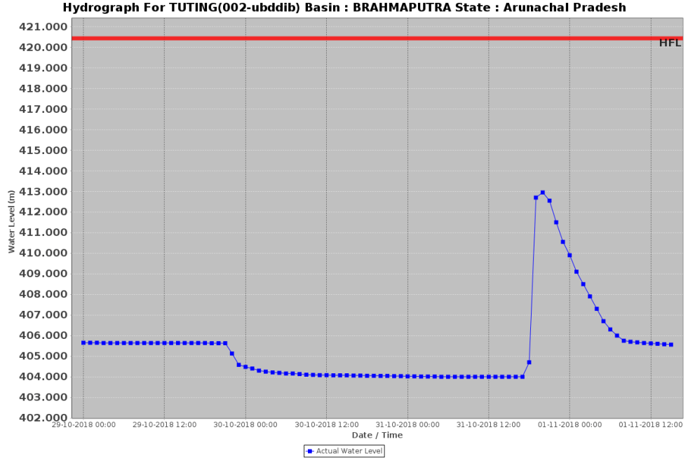
Landslide of Oct 29, 2018 The first information about this landslide was received by CWC around 9 pm on Oct 29. Based on timing of reduction in water level at Tuting, CWC estimates that the new landslide struck at 1100 hours (IST) on Oct 29, 2018, partially blocking the flow of Yarlung Tsangpo, the magnitude and height of the dam were not known, but the size was reported to be approximately half the size of Oct 17 blockage. Water level at Tuting in Arunachal Pradesh had decreased by 1.44 m from around 405.63 m at about 9 pm on Oct 29 to 404.19 m by 5 am on Oct 30 (it further reduced upto 404.06 m by 1700 hrs on Oct 30), as per the Facebook post of CWC Central Flood Control Room[iii]. The water flow and level at Pasighat started reducing at 0700 on Oct 30, 2018, with ten hour delay with respect to Tuting.

However, the notice from Upper Siang district DM on Oct 30 was a bit confusing as it mentioned: “There is also report of unprecedented decrease in volume of water since last night at Tuting.” How can be water flow volume of Siang river at Tuting be reduced unprecedentedly if the blockage was incomplete and about half the size of blockage on Oct 17?
The “Alert” message from Secretary, Disaster Management of Arunachal Pradesh to the District Magistrates of Upper and East Siang districts was also a bit speculative and confusing: “As per the report, the quantity of water discharged by river Yarlung Tsangpo this time is much less then the discharge of recent 17th-20th Oct. It may be half the water discharged during 17th-20th Oct. The discharge may not cause any damage or loss of lives and properties along river Siang but the water level needs to be constantly monitored for 3-4 days wef 30th Oct.” These messages need to be clearer and most precise when possible.
What was strange however was almost complete silence in Chinese media this time about the landslide or about what the Chinese government is doing about it. This was so unlike the Oct 17, 2018 episode when websites of Chinese media agencies like Xinhua and South China Morning Post were full of news, photos and videos of the landslide. This silence is very strange indeed.
Size of reservoir behind landslide dam CWC tweet at 7.22 am on Oct 31, 2018[iv]: As per latest information received from Chinese side, the estimated blocked water storage volume at landslide location (Melin Section of Yarlung Tsangpo in Chinese Territory) at 6.30 hrs IST (9 hrs Chinese time) on 31st Oct 2018 is 337 MCM. Assuming, as per CWC estimate that the landslide dam was formed at 11 hrs (IST) on Oct 29, the reservoir was accumulating water at the rate of 7.747 MCM/hr or 2152 cumecs. If the landslide dam was overtopped at 0900 hours on 31st Oct (see below), the volume of the reservoir at the time of overtopping and breach is likely to be around 357 MCM.
The breach of landslide dam As per CWC hydrograph, water level at Tuting started rising at 1700 hours (IST) on Oct 31, 2018, so the landslide dam is likely to have been over topped at about 0900 hours (IST) on Oct 31.
CWC predicted at 11.42 am on Oct 31, 2018[v]: As per latest dam break simulation, for 330 MCM lake volume and 10 hrs breach development time, the estimated peak discharge at Tuting would be about 15000 cumec. Its travel time from land slide location to Tuting would be about 7.5 hrs.
Another CWC Tweet[vi]: Level at 01:00AM IST 01.11.2018 is 409.10m. Total of 8.95m rise in water level at Tuting due to breach of landslide in Chinese territory. The peak water level of 412.95 m was reached by 7:30 PM and till 8:30 PM flow was steady. After 9:00 PM, the water level started falling gradually.
At Pasighat, water level sprang up from 0400 hours on Nov 1, and continued to rise for next five hours, dropping thereafter.
Chintan Sheth of Biodiversity and Ecosystems Ecology Research Lab said: “Both the 20th and 31st October 2018 outburst flood events, were due to blockages at the same conjunction of the Yarlung-Tsangpo and the Sendapu valley. Its difficult to pinpoint exactly when the landslides occurred because it can’t be narrowed down to a single event that led to the formation of both dams. For example, there was considerable movement of rock and debris on 18th & 19th September, then a larger obvious landslide on 16-17th October, all the way to the Tsangpo. Multiple slides maybe associated with the 29th October blockage.”
Chintan had written in the Arunachal Pradesh Times on Dec 21, 2017 about the October 2017 landslide on the Sendapu valley. In that context he added: “The frequency of the landslides is concerning and warrants a detailed study.” [https://arunachaltimes.in/index.php/2017/12/21/earthquakes-in-tibet-have-triggered-massive-landslides-darkening-the-siang-river/]
In Conclusion In absence of any statement from CWC or MoWR or NDMA explaining the causes and related information, speculations are rife in Arunachal Pradesh, even among Members of Parliament like Ninong Ering[vii] that these repeated landslides, about Chinese activities. There are also no satellite images from NRSC till date. It would be useful for all concerned to come out with necessary information, explanations, images and studies to clarify on this hugely important issues for Arunachal Pradesh and rest of North East India.
SANDRP (ht.sandrp@gmail.com)
POST SCRIPT: David Petley blog on this landslide: https://blogs.agu.org/landslideblog/2018/11/05/yarlung-tsangpo-2/
END NOTES:
[i] https://sandrp.in/2018/10/19/landslide-dam-on-tsangpo-creates-flood-disaster-risk-for-siang/
[ii] https://sandrp.in/2017/12/24/muddy-siang-is-sign-of-danger-ahead-wake-up-call-for-indian-authorities/
[iii] https://www.facebook.com/CWCOfficial.FF/photos
[iv] https://twitter.com/CWCOfficial_FF/status/1057450206634029056
[v] https://twitter.com/CWCOfficial_FF/status/1057515577491755008
[vi] https://twitter.com/CWCOfficial_FF/status/1057731664023965697

It’s a shame you don’t have a donate button! I’d most
certainly donate to this excellent blog! I suppose for now i’ll settle for book-marking and adding your RSS feed to my Google account.
I look forward to brand new updates and will talk about this site with my Facebook group.
Chat soon!
LikeLike
Thanks so much, Rachel. Keep sending such encouraging feedback and do share info about our blog widely.
Himanshu
LikeLike